Introduction
The assessment and clean up of contaminated land can be time consuming and expensive, particularly in polar environments such as Antarctica (Snape et al. Reference Snape, Riddle, Stark, Cole, King, Duquesne and Gore2001a, Poland et al. Reference Poland, Riddle and Zeeb2003). Therefore, preliminary site investigations should be undertaken to facilitate effective clean up over concurrent field seasons (Gibson et al. Reference Gibson, Lyle and George1996, Stark et al. Reference Stark, Snape and Riddle2006). This typically requires an assessment of the type, forms, distribution and extent of contamination at a site. These assessments may be hindered by remoteness, financial and logistical constraints, extreme weather and a shortage of governing guidelines and legislation (Snape et al. Reference Snape, Morris and Cole2001b, Poland et al. Reference Poland, Riddle and Zeeb2003, Snape et al. Reference Snape, Riddle, Filler and Williams2003). Furthermore, old waste disposal sites are often poorly documented and, where snow and ice has buried material, their location and boundaries are often obscured (Stark et al. Reference Stark, Snape and Riddle2006). Thus establishing definitive timeframes for clean up are often hampered by limited knowledge of precise locations of waste.
Annex III to the Protocol on Environmental Protection to the Antarctic Treaty (1991), known as the Madrid Protocol, prohibits the discharge of waste onto ice-free areas and soils in Antarctica (SCAR 1993, Webster et al. Reference Webster, Webster, Nelson and Waterhouse2003, Bargagli Reference Bargagli2008). Waste storage, disposal and removal, as well as recycling and source reduction, are important operational considerations under Article 1(3) of Annex III (SCAR 1993). Prior to the Madrid Protocol, less stringent controls on the use, storage and disposal of waste, coupled with a limited awareness of the risks posed to the environment by inappropriate disposal of waste, resulted in contamination near research stations by fuel residues, solid wastes and leachates (Snape et al. Reference Snape, Riddle, Stark, Cole, King, Duquesne and Gore2001a, Webster et al. Reference Webster, Webster, Nelson and Waterhouse2003, Bargagli Reference Bargagli2008). Waste from most Antarctic stations was typically dumped in landfills close to the station, disposed of onto sea ice and allowed to drift out to sea or burnt in open air (Poland et al. Reference Poland, Riddle and Zeeb2003, Stark et al. Reference Stark, Snape and Riddle2006, Bargagli Reference Bargagli2008, Fryirs et al. Reference Fryirs, Snape and Babicka2013).
The Madrid Protocol established the obligation for assessment and clean up of abandoned work and waste disposal sites (Stark et al. Reference Stark, Snape and Riddle2006, Bargagli Reference Bargagli2008). Amongst others, clean-up operations have been conducted at the Thala Valley landfill at the Old Casey Station (Deprez et al. Reference Deprez, Arens and Locher1999, Snape et al. Reference Snape, Riddle, Stark, Cole, King, Duquesne and Gore2001a, Reference Snape, Morris and Cole2001b, Stark et al. Reference Stark, Snape and Riddle2006), Atlas Cove Station on Heard Island (Stark et al. Reference Stark, Gardner, Snape and McIvor2003), Vanda Station and Cape Hallet Station in Victoria Land (Waterhouse Reference Waterhouse1997, Roura Reference Roura2011) and along the eastern shoreline of Winter Quarters Bay near the McMurdo Station (Manheim Reference Manheim1992, Massey Reference Massey1992, Claridge et al. Reference Claridge, Campbell, Powell, Amin and Balks1995, Crockett & White Reference Crockett and White2003, Bargagli Reference Bargagli2008). Clean-up operations at McMurdo Station focussed on the removal of exposed and surface waste material, leaving buried landfill material in situ (Manheim Reference Manheim1992, Stark et al. Reference Stark, Snape and Riddle2006). Australian Defence Force clean-up operations in 1991–92, 1992–93 and 1993–94 (Fryirs et al. Reference Fryirs, Snape and Babicka2013) focussed on rendering safe any explosives and gas bottles, leaving significant volumes of buried landfill material at the abandoned Wilkes Station.
Decades of snow and ice accumulation at Wilkes have resulted in the concealment of legacy waste, with the precise location of the landfill remaining largely unknown. Fryirs et al. (Reference Fryirs, Snape and Babicka2013) estimated the landfill area at c. 100 x 250 m, comprising c. 20 000 m3 of material. During a short summer melt period, metal and petroleum hydrocarbon contaminated groundwater has been reported flowing from the landfill into the neighbouring marine environment (Snape et al. Reference Snape, Cole, Gore, Riddle and Yarnall1998, Townsend & Snape Reference Townsend and Snape2008, Fryirs et al. Reference Fryirs, Snape and Babicka2013). The high variability of snow deposition and summer thaw at Wilkes makes it economically risky to plan major efforts on the expansive waste dump because shipping capacity, specialized plant and equipment, and personnel must all be engaged well in advance of field operations which may be rendered impractical or impossible by snow and ice conditions (Roura Reference Roura2011). Article 8(3) of Annex III to the Madrid Protocol requires Treaty Parties to prepare an inventory of locations of past activities before information is lost (SCAR 1993, Deprez et al. Reference Deprez, Arens and Locher1999). Ground magnetometry provides a rapid, non-invasive method for identifying landfill boundaries, recovering lost information and aiding the development of clean-up strategies.
Previous geophysical investigation at the Wilkes landfill consists of reconnaissance ground penetrating radar (GPR) surveying, coupled with geographical information system database development (Babicka Reference Babicka2000). Ground magnetometry has been widely applied in temperate regions for subsurface detection of steel drums, tanks, unexploded ordnance and pipes (Tyagi et al. Reference Tyagi, Lord and Koerner1983, Barrows & Rocchio Reference Barrows and Rocchio1990, Roberts et al. Reference Roberts, Hinze and Leap1990, Marchetti et al. Reference Marchetti, Chiappini and Meloni1998, Godio Reference Godio2000, Prezzi et al. Reference Prezzi, Orgeira, Ostera and Vasquez2005). However, use of this technology has been limited to geological and archaeological investigations in polar regions (Chaparro et al. Reference Chaparro, Nunex, Lirio, Gogorza and Sinito2007, Hodgetts et al. Reference Hodgetts, Dawson and Eastaugh2011). This study applies the magnetic method to characterize the spatial extent, distribution and depth of ferrous materials in the Wilkes landfill. Potential anomalies associated with magnetic minerals in the bedrock and glacial sediment were accounted for using rock magnetic susceptibility. A magnetometer survey for this purpose was conducted across two days during the 2012–13 field season.
Study area
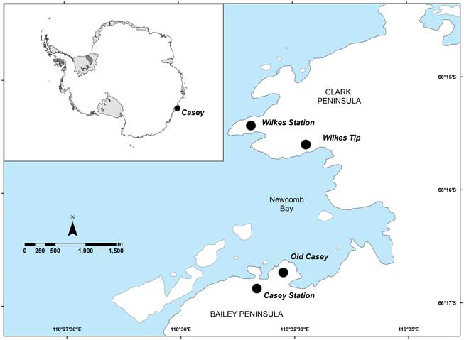
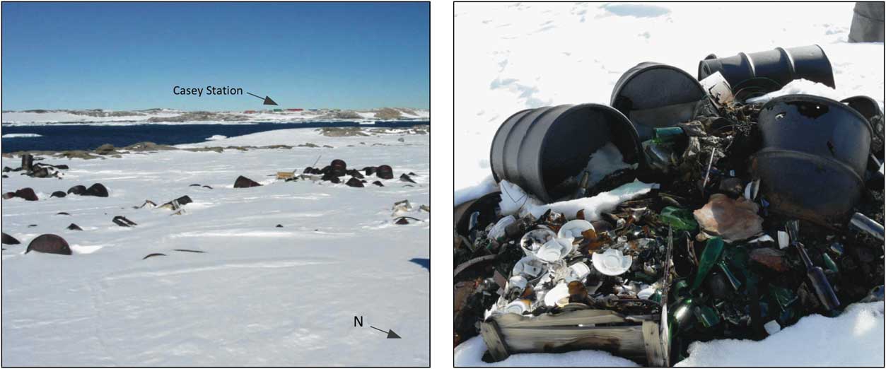
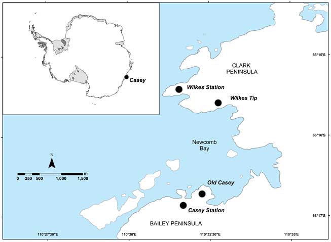
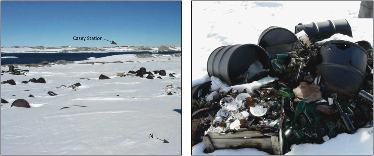
Wilkes is an abandoned research station established in the International Geophysical Year (IGY) 1957–58 and operated by the USA from 1957–59 and by Australia between 1961–69. Wilkes is situated on Clark Peninsula, c. 3 km north of Old Casey Station and was decommissioned in 1969 due to ongoing snow and ice accumulation (Fig. 1) (Snape et al. Reference Snape, Cole, Gore, Riddle and Yarnall1998). Due to logistical constraints, the removal of buildings, equipment and waste was not undertaken (Fryirs et al. Reference Fryirs, Snape and Babicka2013). Consequently, around 40 buildings, mechanical equipment, a fuel farm and a landfill remain in situ (Snape et al. Reference Snape, Cole, Gore, Riddle and Yarnall1998, Fryirs et al. Reference Fryirs, Snape and Babicka2013). The landfill is 800 m south-east of the station precinct and is comprised of mechanical and domestic items including drums, food containers, batteries, mechanical spares and gas cylinders (Fig. 2) (Fryirs et al. Reference Fryirs, Snape and Babicka2013). Some of these materials breach the ice surface during major melt years, such as in 2002–03 (Fig. 2). Mean daily temperature is 3°C and -20°C in the summer and winter months, respectively (Deprez et al. Reference Deprez, Arens and Locher1999).
Regional map of Wilkes.
Waste material exposed during a large melt at Wilkes during 2002–03. (Photos courtesy of Bill Burch).
The Wilkes basement is polymetamorphic with granulites, magmatic pelites, psammites and granite gneisses of the Windmill Metamorphic Series (Blight & Oliver Reference Blight and Oliver1977, Paul et al. Reference Paul, Stüwe, Teasdale and Worley1995). The Windmill Metamorphic Series was formed in the Mesoproterozoic era between 1600–1000 million years ago (Paul et al. Reference Paul, Stüwe, Teasdale and Worley1995).
Surficial sediments are several metres thick in low-lying depressions and are largely unconsolidated coarse sands and gravel (Snape et al. Reference Snape, Cole, Gore, Riddle and Yarnall1998). However, larger clasts and regional variability is common. The porous material undergoes many freeze-thaw cycles annually, creating melt streams on the ice surface and at the ice-sediment/rock interface which result in contaminated water flow (Snape et al. Reference Snape, Cole, Gore, Riddle and Yarnall1998). Contaminated subsurface water movement also occurs via small channels at the base of the sediment active layer (Snape et al. Reference Snape, Riddle, Stark, Cole, King, Duquesne and Gore2001a). Subsurface channelling can also be associated with dykes or sills that produce detectable magnetic anomalies against the surrounding basement geology (Blight & Oliver Reference Blight and Oliver1977). A large hydrocarbon sheen observed on the seawater across Newcomb Bay during a major melt period in 1992 is evidence of offsite contaminant transport (Potter, personal communication 1992 in Fryirs et al. Reference Fryirs, Snape and Babicka2013).
An excavation of the landfill was undertaken during November 2012. This excavation revealed an ice thickness of 1.7 m overlying landfill material and frozen sediments. The Wilkes landfill is unlined and has no leachate collection system to isolate waste from the environment (Roura Reference Roura2011).
Materials and methods
Magnetometry
The magnetic survey was performed using a GeoMetrics Inc G-856 Proton Precession Magnetometer. This instrument was selected as it is not impeded by high electrical ground conductivities commonly associated with saline groundwater or high levels of contamination (Affrin unpublished, www.fskk.ukm.my/rahim/G-Magnetics%20Methods.pdf, accessed March 2013). The sensor was mounted vertically on a lightweight non-magnetic pole 2.5 m above the ground to distance it from metal detritus at the surface. As part of quality assurance and quality control procedures, several magnetic readings were taken at the beginning and end of each day's work to ensure the magnetometer was operating consistently. All readings were obtained with the sensor orientated north-south for greater pole-to-pole anomalies (Breiner Reference Breiner1999). Total field strength was reported in nanotesla (nT) with an average positional error of c. 1 nT. Diurnal variation was corrected at 1-minute intervals using the Casey Station EDA 3-component flux-gate magnetometer (Geoscience Australia 2013, www.ga.gov.au/earth-monitoring/geomagnetism.html, accessed February 2013). Belt buckles, watches, handheld transceivers and other metal items were removed while surveying to prevent interference with sensor operation.
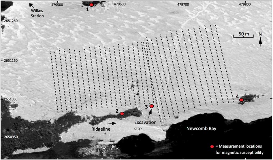
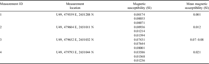
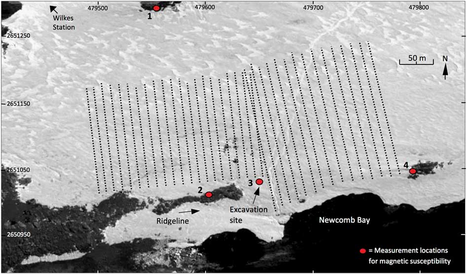
Magnetic susceptibility measurements were carried out using a portable magROCK Susceptibility Meter (750 Hz), Alpha Geoscience Pty Ltd (range 1 x 10⁻⁵ - 10 SI units). Field measurements were acquired from three surrounding ridgelines and from the excavation pit to ensure mineralogical variability was accounted for in the measurements (Fig. 3). The meter was zeroed in air after each reading. These readings provided a background susceptibility and contrast with subsurface landfill properties that ensure accurate depth to material (based on present ice thickness) could be delineated (Breiner Reference Breiner1999).
Magnetometer survey profiles at the Wilkes landfill (© Google Earth 2013/MagPick).
Magnetic data were uploaded to GeoMetrics MagMap2000, a post-acquisition processing and analytical tool. Using MagMap2000, magnetic data were spatially adjusted from dGPS site measurements and diurnal corrections were made using base station flux-gate magnetometer readings. Magnetic and spatial information data were then exported to Golden Software's Surfer 9 mapping programme for display. Where landfill material was detected, modelling of magnetic anomalies and susceptibilities was conducted using Model Vision Software V.12.00.07 (Tensor Research).
Survey set-up
A 350 x 150 m survey grid was constructed, guided by previous GPR surveying (Fig. 3) (Babicka Reference Babicka2000). The survey was conducted along north-south parallel lines with 36 profiles forming the grid. Each profile was spaced 10 m apart. Total field magnetic readings were acquired every 2 m to ensure multiple readings were obtained for any anomaly encountered. Where landfill material was subsequently observed to protrude further south, survey lines were extended beyond 150 m to capture material in these areas (Fig. 3). Spatial information was recorded using a Trimble dGPS Pathfinder ProXH™ Rover with decimetre accuracy in real-time. The limited battery life of the Trimble ProXH™ base station dGPS, situated at an accurately-known fixed location at Wilkes Station, resulted in only start and end points of each line being recorded. Interpolation and mapping of lines was conducted using ESRI ArcGIS 10.1 Software.
Results
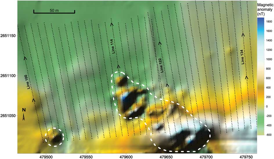
Wilkes landfill possesses sufficient magnetic properties to be distinguishable as an anomalous feature within the survey area (Fig. 4). While Fig. 4 indicates a positive anomaly (observed as a surface fuel drum) in the west of the survey area (200–400 nT), the cluster of high amplitude anomalies in the centre of the survey area suggests the main waste deposit extends 160 m south-east to the northern boundary of Newcomb Bay (Fig. 3). From the anomalies generated, it is estimated that the main waste deposit covers 6250 m2 and comprises 17 000 m3. The estimate of the size of the waste deposit is taken simply from the volume of the polygons (strike length 30 m) used to model the magnetic data (Model Vision V.12).
Wilkes landfill delineation from magnetometer measurements (MagMap2000/Surfer 9).
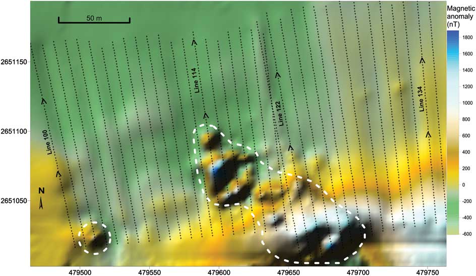
An increase in magnetic intensity from north to south indicates that the surrounding geology had a significant influence on the data generated (Fig. 4). Geomagnetic properties in the north of the survey area (-200 nT, 0.001 SI units) progressively strengthen to the south (> 1000 nT, 0.012 SI units), producing similar magnetic readings to landfill material and reducing image clarity in the south of the survey area (Table I, Fig. 4). Despite geomagnetic distortion, anomalies of > 1500 nT amongst bedrock readings of 1000 nT clearly defined the boundaries between natural structures and waste material (Fig. 4).
Magnetic susceptibilities of the surrounding geology at Wilkes landfill. (Measurement ID on Fig. 3).

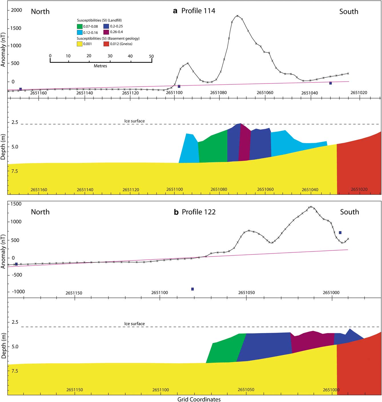
The sharpness of magnetic anomalies suggests the variable depth of material in the northern section of the landfill (Fig. 4). A high amplitude anomaly between 1700–1800 nT and modelled susceptibilities between 0.26–0.4 SI units are indicative of greater amounts of ferrous objects (Fig. 5a). Adjacent to this peak, lower amplitude anomalies (400–500 nT) and magnetic susceptibilities (0.07–0.25 SI units) indicate waste material at greater depths (Fig. 5a). While modelled susceptibilities vary along profile 114 (Fig. 5a), anomaly wavelength remains similar suggesting waste material composition is continuous. Polygon shape by strike length modelling in this section estimates material volume at 3900 m3.
Models of the magnetic data for profile 114 and profile 122 (Model Vision). Blocks represent different magnetic susceptibilities and show the waste material sitting on the geological basement.
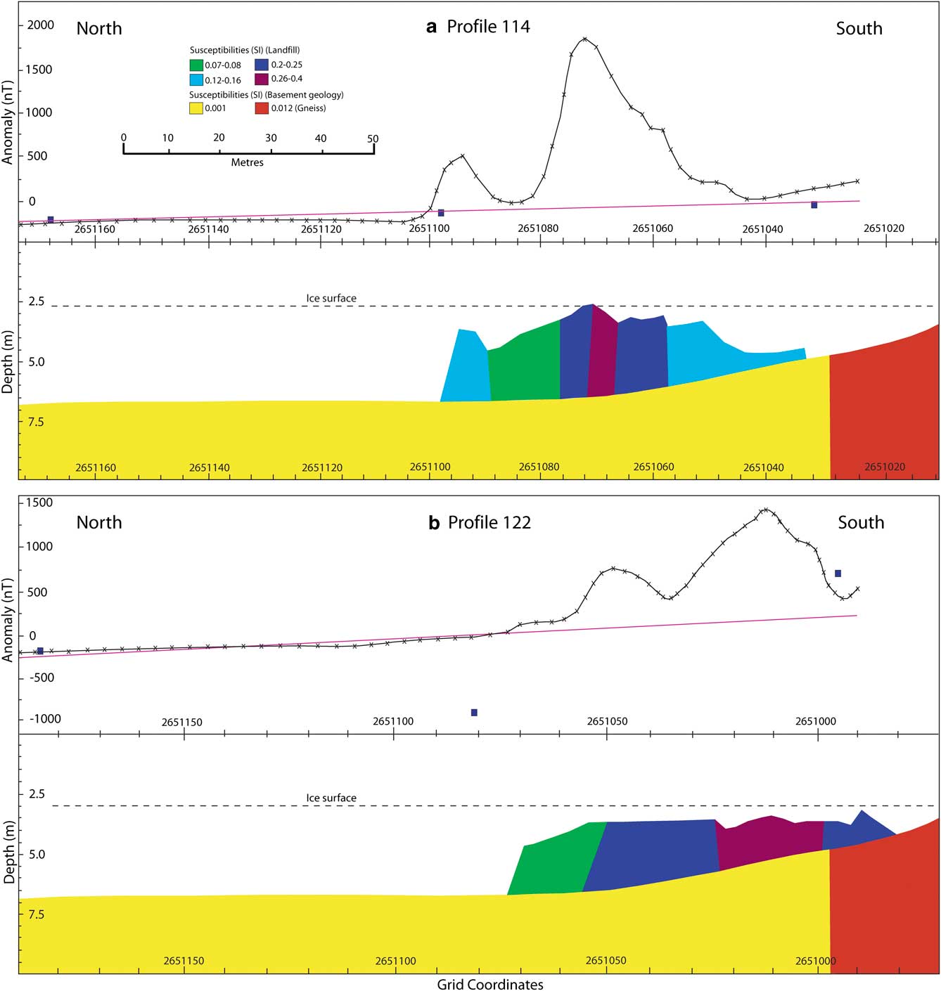
Modelling of profile 122 provided information on the characteristics in the central and southern zones of the landfill (Fig. 5b). In the centre of the outlined landfill site, lower amplitude anomalies are present averaging 500–800 nT (0.07–0.08 SI units) with peak amplitude at 1100 nT (Table I, Figs 4 & 5b). Profile 122 illustrates that the anomalies of interest are superimposed on a much broader anomaly which we attribute to the magnetic properties of the bedrock. Small, scattered anomalies suggest the presence of small ferrous fragments amongst a sediment matrix. This waste distribution is supported by an excavation during November 2012 (Fig. 3). The southern section of the landfill is characterized by larger anomalies attributable to surface melt exposing waste material (Figs 2 & 5b). Anomaly maxima in this section was 1500 nT with an average of around 800–900 nT (Figs 4 & 5b). A 3 x 4 m section of exposed landfill material is partially responsible for anomaly amplitude exceeding values in the centre of the landfill (cf. Fig. 2). The high and fluctuating magnetic susceptibilities (0.2–0.4 SI units) again confirm the presence of large amounts of ferrous material below the bedrock ridgeline. Polygon shape by strike length modelling in this section estimates material volume at 4700 m3.
These high magnetic values are also attributable to a ridgeline susceptibility of 0.021 SI units (acquired east of profile 134), indicative of c. 0.6% magnetite in the surrounding geology (Breiner Reference Breiner1999) (Table I, Fig. 4). This is responsible for the elevated readings (> 1000 nT) beyond the landfill boundary in the south-east corner of the survey area (Fig. 4). In the absence of anomalies associated with randomly distributed metallic objects and the presence of broad, smooth wavelengths (Fig. 4), we infer that this region is free of large waste material. However, the complex interaction between buried ferrous objects and geology may mask smaller waste items in this zone. Therefore, this area neighbouring the landfill site requires further investigation before being declared devoid of waste material. While surveying to the ice edge was prohibited for safety reasons, gas cylinders observed on the shoreline of Newcomb Bay suggest that the landfill may also extend beyond the survey limit in that direction.
Discussion
Approximately 7000 fuel drums remain in situ at Wilkes, 500 of which are almost permanently buried by ice (Snape et al. Reference Snape, Cole, Gore, Riddle and Yarnall1998, Fryirs et al. Reference Fryirs, Snape and Babicka2013). The location and removal of these drums is paramount to the environmental protection of Clark Peninsula (ATCM 2009, Fryirs et al. Reference Fryirs, Snape and Babicka2013). Metal drums exhibit strong magnetic anomalies and, when dumped randomly, will produce large-amplitude but highly variable anomalies (Barrows & Rocchio Reference Barrows and Rocchio1990, Gibson & George Reference Gibson and George2003). Prezzi et al. (Reference Prezzi, Orgeira, Ostera and Vasquez2005) report that drums buried at 1 m depth produce anomalies of > 1500 nT, while at 1.5 m anomalies decrease to c. 300 nT. Therefore, anomaly amplitudes generated in the north of Wilkes landfill suggest the highest concentration of buried steel drums across the landfill area. The short wavelength and depression between anomalies suggests that steel drums have been piled near the surface resulting in regular exposure during the summer months. However, this exposure and measured wavelengths are subject to annual variation, regulated by the intensity and path of summer melt flows. The unevenly configured fall-off rate and asymmetry of the main peak also reveals voids between material and suggests that drums were empty when dumped or have since discharged fuel (Barrows & Rocchio Reference Barrows and Rocchio1990, Breiner Reference Breiner1999). Recognising that many of the drums may still contain fuel is critical if ‘dig and haul’ clean-up techniques are implemented at the site.
The broader wavelength anomalies produced further south suggest a response derived from the geology of the area. Historical observations indicate that many ferrous objects were dumped prior to 1961 and progressively melted or sank into the snow and soft sediments during the warm summer months (Burch personal communication, 2013). Since Wilkes was the last IGY station to be established by the USA, leftover machinery, building materials and transport vehicles from previously constructed stations were unloaded on the shoreline of Newcomb Bay (Burch personal communication, 2013). This explains the high amplitude and erratic anomalies generated south of the bedrock ridgeline, as well as the southern tip of the landfill positioned within metres of the shoreline (Fig. 5b). Alternatively, sharp magnetic boundaries and more evenly spaced anomalies in the northern section (Fig. 5a) suggest material organization and surface stacking, perhaps immediately prior to the decommissioning of Wilkes Station. As landfill material has accumulated through varying operations above and below the ridgeline (Prezzi et al. Reference Prezzi, Orgeira, Ostera and Vasquez2005), there is a pattern of tipping histories and zonation of waste at the Wilkes landfill. While historical communication provides some insight into waste zonation, it is not known whether this is significant for contaminated leachate generation and the off-site movement of contaminants.
Anomaly variation between the two survey dates provides insight into the influence of ice thickness on the magnetic values acquired. While survey profile 120 (23 December 2012) and profile 121 (21 January 2013) overlap in the central section, an increase from c. 900 nT (profile 120) to c. 1050 nT (profile 121) occurs at the point of intersection. While dGPS measurement accuracy between the two survey dates may contribute to this offset in magnetic intensity, a higher amplitude anomaly is probably associated with buried material being closer to the surface due to melting of the ice. This is supported by comparing the results of an excavation earlier in the 2012–13 field season where ice thickness was recorded at 1.7 m with observations on 23 December 2012 where material fragments were observed at the surface. Thus, the summer melt is intertwined with the magnetic anomalies produced at the Wilkes landfill and annual variability in measurements should be expected both within and between field seasons. From engineering and management perspectives, this may positively or negatively impact clean-up timeframes. Depth perceptions are particularly important for clean-up operations when landfill sites are adjacent to marine ecosystems as surface disruption may mobilize potentially harmful contaminants.
The clean up and removal of landfill material at Wilkes is required under the Protocol on Environmental Protection to the Antarctic Treaty (1991). As clean up of the landfill will occur over multiple field seasons, ground magnetometry can be applied to prioritize locations for material removal. The bedrock ridgeline occurs at a higher elevation than the landfill (Fig. 5a & b), providing a trapping mechanism for contaminants migrating in the soil profile from the north of the landfill. Furthermore, with material 1–2 m below the ice surface in the north (Fig. 5a), disturbance could enhance and concentrate melt stream flow capacity and flush contaminants in the lower sections of the landfill. As this zone is located c. 150 m from Newcomb Bay, it may not pose an immediate threat to the marine environment.
In contrast, subsurface waste material detected south of the bedrock ridgeline probably poses a more urgent threat to the marine ecosystem. Subsurface imaging shows no topographical barriers to contaminant migration with large melt streams recorded across this region (Snape et al. Reference Snape, Cole, Gore, Riddle and Yarnall1998). Clean up of landfill material downhill of the ridgeline should be a priority in order to prevent greater adverse environmental impacts in accordance with Article 1(5) of Annex III (SCAR 1993). Subsequent clean up in the north of the landfill may require the installation of a permeable reactive barrier in the south to ensure contaminants migrating off-site are captured and treated effectively (Snape et al. Reference Snape, Morris and Cole2001b).
Although this survey provided detailed mapping of subsurface ferrous properties at Wilkes, magnetometry profiling may not be a universal technique for the complete characterization of a landfill site (Gibson et al. Reference Gibson, Lyle and George1996, Gibson & George Reference Gibson and George2003). With the lateral dispersal of water-borne contaminants occurring via both surface and subsurface melt streams at Wilkes (Snape et al. Reference Snape, Cole, Gore, Riddle and Yarnall1998), resistivity surveys during melt periods are crucial for detecting and tracking contaminant plumes. Understanding the interaction between waste material type and subsurface flow paths is essential in order to manage contaminant leaching during clean-up operations at landfills where geo-membrane liners were not installed, such as at Wilkes.
Conclusions
Ground magnetometry was well suited to the spatial characterization of the landfill at Wilkes. Buried material and the boundaries of the landfill were clearly delineated from anomalies produced. Buried drums, which can contain dangerous pollutants, were identified with high amplitude anomalies of > 1000 nT in the north of the landfill. Varying amplitudes were used to infer the presence of smaller metallic material amongst steel drums. These data provide a platform for developing and implementing future clean-up strategies at the Wilkes Station landfill.
Acknowledgements
We thank Kathryn Mumford and Tom Statham for assistance in conducting the survey, Bill Burch for information regarding past activities at Wilkes, and Greg Hince, Dan Wilkins and the Australian Antarctic Division for logistical support. We also gratefully acknowledge the three anonymous reviewers for their valuable comments on an earlier version of this manuscript. This research was supported under Australian Antarctic Science Grant 4029.