

Mobile communication technology has been the most rapidly adopted technology in all of human history. Recent statistics from the International Telecommunications Union reveal that some 5.3 billion mobile phones existed by the end of 2010, a figure that represents a 25% increase over just the previous year.Footnote 1 By the end of 2012, the number of mobile-connected devices is expected to exceed the world's population.Footnote 2 In addition, over two billion people worldwide now have access to the Internet, with half a billion of these accessing the Internet by mobile phone – a number set to double by 2015.Footnote 3 Indeed, mobile data traffic is projected to increase eighteen-fold by 2016, and the Middle East and Africa are forecasted to have the strongest mobile data traffic growth of any region in the world, followed by Asia.Footnote 4 Meanwhile, the number of Facebook users is rapidly approaching 1 billion while more than 100 million active Twitter users are sending over 1 billion tweets every week.Footnote 5 Finally, more than 500 million Skype users are now talking for free thanks to voice-over IP technology. Staggering though these figures may be, the information revolution is only just getting started.Footnote 6
Today's information revolution, however, is not only about greater access to information and communication channels. The dramatic fall in communication costs combined with the real-time, two-way nature of social media platforms is increasingly responsible for this revolution. Of course, some new technologies are acting as veritable connection technologies that facilitate both organization and collective action more rapidly and with more scalability than ever before. Indeed, the rapid spread of new information and communication technologies (ICTs) is democratizing information access, participation, and agency. What are the implications for the humanitarian space and how can organizations responding to crises make use of these technologies and the new players that come with them?
The purpose of this article is to assess the impact of new ICTs on the humanitarian sector. It focuses on the response to specific humanitarian crises – in Haiti, Russia, Libya, and Somalia – to illustrate how crisis-mapping technologies and digital volunteers are changing humanitarian organizations.Footnote 7 Each of these case studies highlights the different facets of humanitarian response that new technologies are changing. For example, ICTs are changing the ways in which information is collected and processed; they are bringing new volunteer networks to the fore of humanitarian response; and, as a result, they are spurring organizational change within established humanitarian organizations. One of the common threads in each of these case studies is the use of crisis maps to aid humanitarian response. The first section of the article introduces the new field of crisis mapping and the underlying technologies that power live crisis maps. Sections two, three, four, and five comprise crisis-focused case studies of crisis mapping in action. The sixth and final section weaves together the lessons learned from the case studies and formulates some recommendations on this basis.
Crisis mapping
The proliferation of live maps is driven by the increasing availability of real-time geo-referenced data and new mapping technologies that are often free, open-source, and easier to use than earlier, proprietary systems. This new frontier in the field of geography is commonly referred to as ‘neogeography’ and consists of:
techniques and tools that fall outside the realm of traditional GIS, Geographic Information Systems. Where historically a professional cartographer might use ArcGIS, talk of Mercator versus Mollweide projections, and resolve land area disputes, a neogeographer uses a mapping API like Google Maps, talks about GPX versus KML, and geotags his photos to make a map of his summer vacation. Essentially, neogeography is about people using and creating their own maps, on their own terms and by combining elements of an existing toolset. Neogeography is about sharing location information with friends and visitors, helping shape context, and conveying understanding through knowledge of place.Footnote 8
The birth of neogeography is often traced back to Google's acquisition of Keyhole Inc. in 2004, which led to the launch of Google Earth that same year. Google Maps went live shortly thereafter. Together, these mapping platforms went a long way to democratize interactive mapping and broaden public access to satellite imagery. In 2007, the Harvard Humanitarian Initiative (HHI) at Harvard University launched a two-year programme on Crisis Mapping and Early Warning to study the potential use of live mapping technologies in humanitarian response.Footnote 9
The focus on crisis meant that collecting and displaying information in real time was imperative. The programme thus catalysed conversations between a wide number of technology professionals, geographers, and seasoned humanitarian practitioners. Recognizing the tremendous potential that existed, HHI launched the International Network of Crisis Mappers, a global network of some 4,000 members in over 150 countries actively interested in the application of live mapping technologies to crisis situations. Established in 2009, the Crisis Mappers Network has since become an important part of the neogeography story.Footnote 10
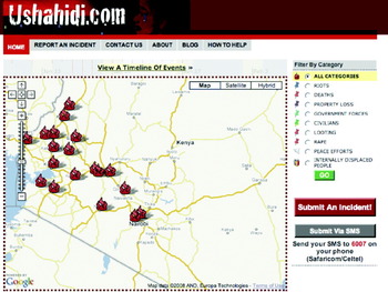
Another milestone was the launch of the first Ushahidi map in 2008.Footnote 11 This simple web-based platform allowed Kenyans to report human rights violations during the post-election unrest.Footnote 12 Witnesses submitted these reports via web-form, email, and SMS. Reports from the mainstream media were also mapped. This enabled the ‘crowd’ to bear witness collectively to the unfolding violence across the country. Since then, over 20,000 Ushahidi maps have been launched in more than 140 countries. The launch of a hosted version of the Ushahidi platform – Crowdmap – in 2010 accounts for the majority of these maps. What is perhaps novel about the Ushahidi mapping technology is that it is free, open-source, and easier to use than proprietary tools. In addition, the information mapped on the platform is often ‘crowdsourced’ live, rather than collected months later.Footnote 13 This is particularly true for crisis-mapping applications of the Ushahidi platform. Of note are the crisis maps launched in Haiti, Chile, Pakistan, Russia, Syria, Tunisia, Egypt, New Zealand, Sudan, Libya, and, most recently, Somalia.
Screenshot of the first Ushahidi platform, launched in Kenya in January 2008.

The taxonomy of crisis mapping is still evolving, but there are four core pillars or phases that are typically discussed when speaking about it: information collection, visualization, analysis, and decision support. Before information is mapped, it needs to be collected. Today's technologies provide more possible channels for information collection than before and also new methodologies. For example, information can be collected from the social media space, such as Twitter. In addition, crowdsourcing can be used as a methodology to collect information from Twitter. The key component, however, is that the data collected have a geographic component so that the information can be visualized – the second phase of crisis mapping. The consequences of these new information collection technologies and methodologies for humanitarian response are vast: when disaster strikes, access to information is just as important as access to food and water. This link between information, disaster response, and aid was officially recognized by the Secretary-General of the International Federation of the Red Cross and Red Crescent Societies (IFRC) in the 2005 World Disasters Report.Footnote 14 Since then, disaster-affected populations have become increasingly digital, thanks to the widespread adoption of mobile technologies. Indeed, as a result of these mobile technologies, affected populations are increasingly able to source, share, and generate a vast amount of information, which is completely transforming disaster response.
In terms of crisis-mapping visualization, there are more bad ways to visualize information than good ways. So cartography remains as important as ever, and more challenging since the underlying data is increasingly dynamic rather than static. In other words, visualizing data over time and space, such that patterns become visible and intuitive, is an important component of crisis mapping. But not all patterns are immediately discernible via simple visual analysis. This explains why geo-spatial analysis is also core to crisis mapping. Bringing otherwise hidden patterns to the surface by using GIS analysis and spatial econometrics enables users to make more informed decisions – the fourth and final pillar of crisis mapping. Of course, the ultimate purpose of crisis mapping is to provide better situational awareness so as to make more informed decisions. This means that crisis-mapping platforms should also serve as decision-support tools that enable users to simulate different scenarios and thereby identify the best path forward during crisis response.
The three case studies that follow illustrate how crisis mapping and new technologies intersect to impact the humanitarian sector in at times unexpected but profound ways.
Responding to the Haiti earthquake
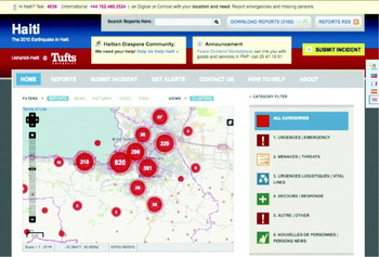
The devastating earthquake that struck Port-au-Prince in January 2010 resulted in massive casualties. Within hours, a live crisis map of Haiti was launched using the Ushahidi platform. Information on the impact of the disaster was initially collected from online sources, including social media channels such as Facebook and Twitter. Within days, an SMS short code provided by Digicel was integrated with the crisis map. This number, 4636, allowed anyone in Haiti to send in text messages with their most urgent needs and location. These text messages were then translated and geo-located by members of the Haitian diaspora. Here is one example of the kind of text message received: ‘Good morning, in Croix-des-Bouquets at Dagou Block near the market, people are very hungry they don't receive anything, please pass this message for us’.Footnote 15 The most urgent, life-and-death text messages processed by the diaspora were subsequently pushed to the live crisis map of Haiti.Footnote 16 Just ten days after the earthquake, the Head of the US Federal Emergency Management Association (FEMA) publicly noted that this crisis map was the most comprehensive and up-to-date map available to the humanitarian community.
What is striking about this crisis map is both that it was unplanned but large scale and that it was not launched by any professional humanitarian organization. In fact, the entire project was generated by students in a dorm room at Tufts University in snowy Boston, some 1,500 miles north of Haiti. Indeed, the Haiti crisis map was largely a volunteer student effort. It was unplanned because the vast majority of volunteers had never done anything like this before. In fact, no one had. The Haiti crisis map represented the first major attempt to create a live map using new technologies. Ushahidi, Twitter, Facebook, Skype, and Google Docs were just some of the technologies that made this important milestone in crisis mapping possible.
The Ushahidi–Haiti Crisis Map three months after the earthquake struck in January 2010.

What was the impact of this initiative? Some first responders, such as the US Marine Corps, noted that they used the crisis map every second of every day to save hundreds of lives.Footnote 17 An email from the Marine Corps (which was later made public with permission) noted the following:
I cannot overemphasize to you what the work of the Ushahidi/Haiti has provided. It is saving lives every day. I wish I had time to document to you every example, but there are too many and our operation is moving too fast. Here is one from the 22 Marine Expeditionary Unit: ‘We had data on an area outside of Grand Goave needing help. Today, we sent an assessment team out there to validate their needs and everything checked out. While the team was out there, they found two old women and a young girl with serious injuries from the earthquake; one of the women had critical respiratory issues. They were evacuated.’ Your site saved these people's lives. I say with confidence that there are 100s of these kind of stories. The Marine Corps is using your project every second of the day to get aid and assistance to the people that need it most.
The US Coast Guard also stated that they used the map operationally.Footnote 18 The humanitarian community, however, was unsure as to how to make use of the crowdsourced crisis information.Footnote 19 In addition, they raised concerns over the reliability of the information displayed on the Haiti crisis map. The availability of crowdsourced crisis information and a dedicated live crisis map was simply too new for humanitarian organizations to understand how best to use it – particularly in the middle of a major disaster. In any case, this did not prevent American search and rescue teams from maximizing the value of the resource provided by volunteer students to evacuate individuals trapped under the rubble.Footnote 20
In parallel to the Haiti crisis-mapping efforts, hundreds of volunteers from OpenStreetMap (OSM) sprang into action to create the most detailed street map of Port-au-Prince available.Footnote 21 This proved invaluable, since the Google Map of Haiti was particularly sparse, with half of the capital city simply missing from the map. This made the mapping of text messages and tweets particularly challenging. Within days of the earthquake, however, the OSM community was granted access to high-resolution satellite imagery, which enabled them manually to trace roads depicted in the imagery onto their OSM platform. Over 1.4 million edits were made to the OSM map of Haiti during the first month alone.Footnote 22 The Ushahidi–Haiti crisis map quickly switched over to using the OSM map of Haiti instead of Google Maps, which considerably facilitated the ability of volunteers to map actionable data.
The digital humanitarian response to the disaster in Haiti demonstrated an important potential, namely that new technologies and volunteer networks stand to have significant possible impact on the humanitarian sector. This explains why the UN's Office for the Coordination of Humanitarian Affairs (UN OCHA) took active steps several months later to understand better the opportunities and challenges of collaborating with new volunteer networks that are particularly agile with new technologies. Indeed, the main theme of the 2010 International Conference of Crisis Mappers (ICCM 2010) held in Boston was to explore new partnerships between traditional humanitarian actors and new informal networks.Footnote 23 One action-oriented result of ICCM 2010 was the launch of the Standby Volunteer Task Force (SBTF).Footnote 24
Operationally, the Task Force is organized into about a dozen individual teams, each of which focuses on a specific information management process.Footnote 25 For example, the Media Monitoring Team monitors mainstream and social media sources for relevant information; the Geo-Location Team identifies the GPS co-ordinates for events reported by the Media Monitoring Team; the Verification Team seeks to verify the accuracy and validity of information being mapped; and the Analysis Team produces information products as part of regular situation reports provided to the organization that activated the Task Force. Each of these teams has a dedicated page on the Ning social networking platform used by the SBTF. Each team page also includes very specific workflows for the individual teams, along with multi-media training materials such as YouTube videos and Powerpoint presentations.
Since ICCM 2010, the SBTF has grown to more than 800 volunteers in over 80 countries worldwide. The majority of these volunteers are professionals from the technology and humanitarian sectors; most of them have graduate degrees or are completing graduate programmes, including PhD programmes.Footnote 26 The purpose of the SBTF is to provide live crisis-mapping support to humanitarian and human rights organizations who request activation of the Task Force, and the global volunteer network has been engaged in some twenty individual deployments since it was launched in 2010.Footnote 27 These deployments have included partnerships with the UN OCHA, the UN High Commissioner for Refugees (UNHCR), the World Health Organization, Amnesty International USA and several other groups.
These partnerships were launched in response to the crises in Libya, Somalia, and Syria; and following earthquakes and floods in New Zealand, Turkey, Australia, and Colombia. For each deployment, only the necessary SBTF teams are activated – hence the strength of a modular team structure approach. Specific criteria need to be met, however, before the SBTF formally deploys to support an organization. First, the organization seeking to activate the SBTF needs to have the capacity and field presence to respond to a given crisis. Second, the organization needs to demonstrate a direct need for the crisis map and underlying data. Third, the activator of the SBTF needs to specify the duration of the deployment, which must typically be less than two weeks: the comparative advantage of the SBTF is short-term rapid deployments, not extended operations. Fourth and finally, if the Task Force is activated, the organization requesting support must provide regular feedback on how they are using the live crisis map to inform their decision-making. Note that every new volunteer who joins the SBTF is required to sign a Code of Conduct that is based on principles put forward by the International Committee of the Red Cross (ICRC).Footnote 28
On occasion, the SBTF is deployed but not formally. This usually happens when the organization requesting SBTF support does not meet the SBTF activation criteria but still provides compelling grounds. For example, Al Jazeera partnered with the SBTF following the earthquake in Van, Turkey, and again during the snowstorm emergency in the Balkans.Footnote 29 During the first two weeks after the launch, the Balkans crisis map was the most popular page on the Al Jazeera Balkans website, on both a daily and a weekly basis. Even on the first day of the launch, the crisis map very quickly became the most-read item of the week. According to Al Jazeera, the crisis map was also the first to break the news on several incidents. In addition, the map provided the most comprehensive coverage of the snowstorm in the region. Indeed, the content populating the map was also shared via the Al Jazeera television newsroom. While Al Jazeera is obviously not an established humanitarian or human rights organization, they launched a crisis map that provided people living in Turkey and the Balkans with important, timely, and actionable information. Media organizations such as Al Jazeera continue to play an important role with regard to communicating with disaster-affected populations.Footnote 30
In conclusion, digital volunteers played an instrumental – albeit reactive – role in the response to Haiti. Using social media, social networking platforms, SMS, satellite imagery, and open-source software, thousands of volunteers around the world – the majority of them from the Haitian diaspora – sprang into action to help the disaster-affected population in Port-au-Prince. In the process, they created the most detailed and up-to-date crisis map (and street map) available to the humanitarian community. And they did this all online without ever setting foot in Haiti. This case study clearly shows that both disaster-affected communities and digital volunteer networks are fast becoming digital. The former are increasingly the source of real-time information following a crisis, while the latter are rapidly becoming more agile at managing this digital content in near real time in support of humanitarian operations. While the nature of the volunteer response in Haiti was necessarily ad hoc and reactive, this catalysed the launch of a prepared and proactive standby volunteer task force, the SBTF.
Russia on fire and volunteers on the frontlines
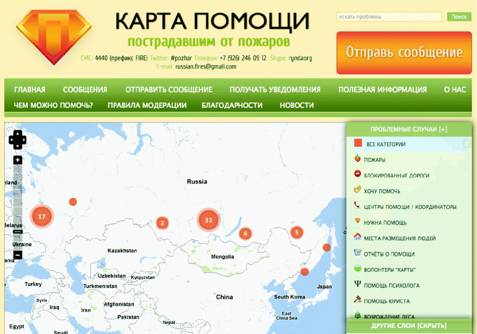
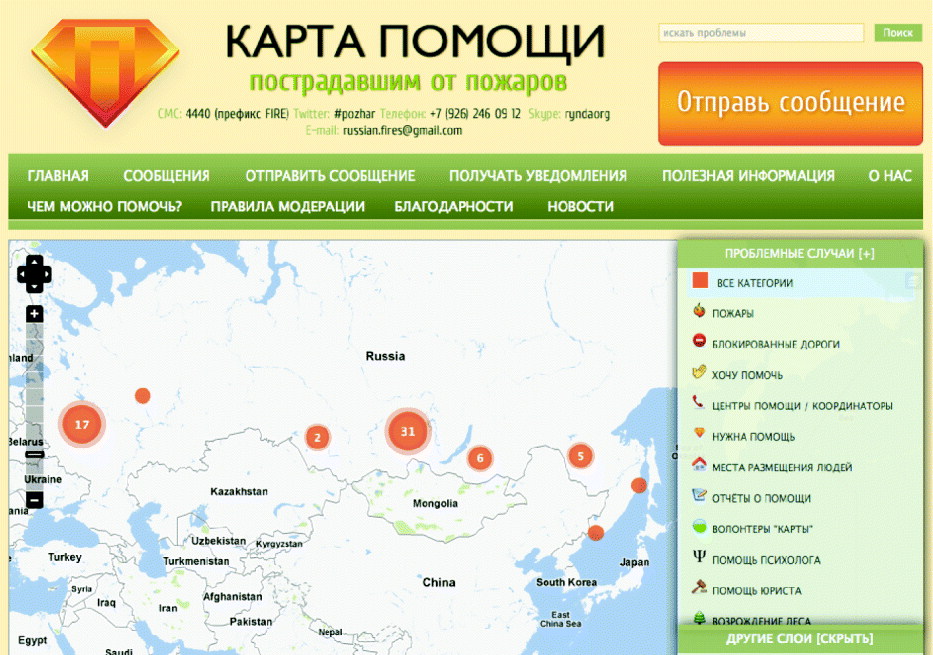
Hundreds of forest fires ravaged Russia during the summer of 2010, killing some 56,000 individuals and causing more than $15 billion in damages. In response, several Russian bloggers who had been inspired by the Haiti response earlier that year decided to launch a live crisis map for the disaster.Footnote 31 Unlike previous live crisis maps, the Russian activists decided to turn the platform into a ‘help map’ by crowdsourcing both needs and offers for help. This was an important departure from previous uses of the Ushahidi platform. Clearly, not everyone is affected in the same way during a disaster or crisis. Those who are less affected often seek ways to help others in need. Providing a platform to facilitate this distributed but self-organized response can improve volunteer co-ordination and response. The first responders are not the search and rescue teams from Iceland who fly in seventy-two hours after a disaster: disaster-affected communities are by definition the first responders. And, whereas professional humanitarian responders cannot be everywhere at the same time, the crowd is always there.
The response to the ‘help map’ was overwhelming, with more than 600 reports mapped during the first week. The team thus decided to set up a co-ordination service and call centre in order to facilitate the matching of needs with the resources being offered. The free, volunteer-run call centre enabled the elderly – and others not otherwise connected to the Internet – to call in their needs or offers of help. In effect, Russian activists were able to launch their own citizen-based disaster response agency in a matter of days by making use of both new and old ICTs. Where was the Russian government in all this? According to Gregory Asmolov,
because of its geographical size, high degree of corruption and reliance on an extraction economy, governance by government in Russia is often weak and ineffective. Russian political expert Liliya Shevtzova goes so far as to claim that the current regime is an imitation of governance. The 2010 wildfires demonstrated the limited capacity of the state to provide effective emergency response. Information technologies, and crowdsourcing platforms in particular, fulfill the gap of the limited statehood.Footnote 32
In other words, not only were citizens helping themselves because of Russia's limited statehood, but they were actually taking over functions of the state, which the map made very explicit (see Figure 3).
Russian fires ‘help map’ used to crowdsource needs and resources.
This live map revealed the great potential for self-organized mutual aid at the community level, particularly in countries where the government is unwilling to react as quickly or incapable of doing so. Indeed, the Russian online community operated both online and offline. Some bloggers created their own volunteer firefighters unit to provide direct assistance to those in need. Others purchased equipment such as fire hoses for professional firefighters. The informal help provided by volunteers was both more rapid and more visible than that of the Russian government. And, unlike the live and public help map, state and commercial mass media did not provide real-time updates to the general public. Indeed, state-controlled television revealed as little information as possible to the public about the fires and smog.Footnote 33 According to one poll conducted at the time, some 68% of people trusted information communicated about the fires via online media, while only 4% of respondents claimed to trust government sources.Footnote 34
In sum, the help map showed that technology can at times replace the functions of government or at least overcome limited state capacity. Like the examples from Haiti and Kenya above, those engaged in these efforts were ordinary volunteers making use of existing technologies. Crisis-mapping technologies can thus act as platforms for self-organization – a match.com to connect local needs with local resources.
The humanitarian crisis in Libya
On 1 March 2011, Brendan McDonald, the Head of OCHA's Information Services Section, requested activation of the Standby Task Force in response to the escalating situation in Libya. OCHA did not have any information management officers (IMOs) in Libya nor could they rely on Libyan government sources for accurate information. In short, the OCHA team had very little situation awareness when they needed it the most (considerable financial resources had to be allocated to responding to spiralling humanitarian needs). So OCHA formally requested crisis-mapping support to improve their situational awareness in Libya. They realized that, whereas little information was available via traditional sources, the social media space was brewing with eye-witness accounts that could potentially provide information on ongoing developments.
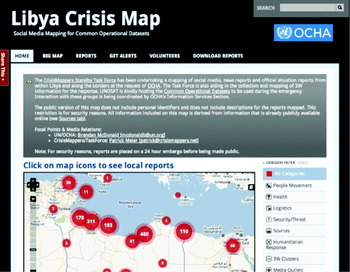
Within hours of the activation request, the SBTF had launched a live crisis map (see Figure 4) powered by the Ushahidi platform, and the Media Monitoring Team was already busy crowdsourcing crisis information in the social media space. While the focus was largely on Twitter and YouTube to begin with, the monitoring soon expanded to mainstream media sources and official humanitarian situation reports once these actors were mobilized and on the scene. In addition to the Media Monitoring Team, the Geo-Location, Reports, Verification, and Analysis Teams were also activated. The only team that was not activated was the Translation Team.
The official Libya Crisis Map of the UN OCHA.

In an unparalleled move, the SBTF deployment in Libya remained active for a total of four weeks, at the request of the OCHA team, making it the longest and most active deployment since the SBTF was launched in 2010. In April, the SBTF handed off the deployment to the OCHA Colombia Team, with the support of UN Volunteers who had been trained by the Task Force. So what was the impact of this combination of new technologies and volunteer networks on the humanitarian sector? In an official email to the SBTF leadership, Brendan McDonald highlighted the following:
Your efforts at tackling a difficult problem have definitely reduced the information overload; sorting through the signals on the crisis is no easy task. The Task Force has given us an output that is manageable and digestible, which in turn contributes to better situational awareness and decision making.Footnote 35
Andrej Verity, OCHA's focal point for the partnership with SBTF noted:
OCHA did not have the idle capacity to gather, verify and process the enormous amount of available online information. In many ways the resulting data behind the map was the ‘gold mine’. OCHA had a data specialist reviewing the data, looking for patterns or trends in the data, showing what ‘non-map’ products could be generated, and outlining how such data could be integrated into traditional coordination products.Footnote 36
The crowdsourced data collected and mapped by the SBTF was in fact integrated into official OCHA infographics and other information products. Verity continued:
The LCM data was being incorporated into the traditional Who-is-doing-What-Where products and info-graphics which were being created remotely by OCHA IMOs [Colombia, DRC, Ethiopia, Kenya, Pakistan, South Africa, and South Sudan]. These products were then being printed and shared inside the emergency arena.Footnote 37
The ultimate operational impact of the map on the ground is unclear, however. The SBTF was not able to obtain details from UN OCHA on exactly how the map was used or what decisions the map served to influence. Josette Sheeran, Executive Director of the World Food Programme (WFP), did publicly note that the Libya Crisis Map could also inform her programme's humanitarian relief operations along the borders, but, again, no further information was subsequently provided.Footnote 38
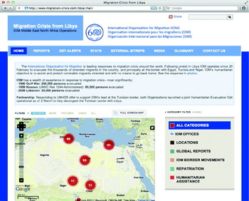
UN OCHA was not the only humanitarian organization to set up a live crisis map in Libya using the Ushahidi platform. Indeed, the International Organization for Migration (IOM) established its own crisis map on 15 March 2011 to provide information on the organization's operations in Libya (see Figure 5). IOM's Information Management Team for the Middle East and North Africa was tasked with categorizing and mapping incoming reports. According to the team lead on this project, the crisis map ‘served to help stranded migrants and provide information on IOM operations’.Footnote 39
The official Libya crisis map of the International Organization for Migration.

UN OCHA have since launched their own live crisis maps for the massive flooding in Colombia and also for refugee flows in Côte d'Ivoire. It is important to keep in mind that these maps, along with the Libya crisis maps, served as only one source of information that UN OCHA, WFP, IOM, and other agencies were drawing on to improve their situational awareness and inform their operations on the ground. Indeed, as one OCHA contact noted, ‘What was the impact of the last map you looked at?’Footnote 40 Humanitarian organizations produce hundreds of static crisis maps as part of their operations, but the direct and individual impact of these is equally challenging to assess. In essence, one would need to closely evaluate existing decision-making structures within humanitarian organizations to understand better how decisions are made in real time.
That being said, there were some interesting, unintended impacts on UN OCHA. Based on some preliminary research, Verity noted that, ‘we can already see that the SBTF has a significant impact on UN OCHA's way of working’.Footnote 41 For example, the collaboration with the Task Force allowed UN OCHA to produce standard information management products much faster than before with respect to the early phases of an emergency. Indeed, the difference in speed was ‘quite stark and significant’. The collaboration with the SBTF also had unexpected consequences in terms of organizational set-up. Indeed, UN OCHA's Information Services Section subsequently adopted a number of the SBTF's strategies vis-à-vis organization and information management. As Verity explains,
The information management team in OCHA HQ was quite impressed with how well the always-open, tiered Skype chats worked in collaborating with the self-organized task-team based volunteers. The team has taken this approach and opened our own group for OCHA Information Management Officers (which has really made our internal IM Community of Practice flourish and provide support to each other). We have leveraged the same approach to help incorporate field-based staff into the development of standard tools and software – something we were rather poor at in the past. As well, when we had one IMO responding to floods in Cambodia, we asked for OCHA IM volunteers and placed them in a dedicated Skype group. We ended up with IMOs from Sri Lanka, Pakistan, Côte d'Ivoire, Liberia and Haiti helping out with the efforts. The OCHA IM team is really learning how we can leverage remote support and are incorporating these concepts into traditional mechanisms.Footnote 42
In short, not only was some of the crowdsourced information produced and mapped by SBTF volunteers integrated within official UN OCHA information products, but the UN's collaboration with the SBTF also led to some cross-fertilization vis-à-vis standard operating procedures that make use of new technologies. Inevitably, there were also a number of challenges that UN OCHA faced when collaborating with the SBTF. For example, the SBTF was ‘always on’: because volunteers are located in different time zones around the world, there are always volunteers working on a deployment. This meant that UN OCHA was faced with the need to respond to volunteers around the clock.
The Libya crisis maps provide an important contrast to the Russian help map and the Haiti crisis map. Indeed, unlike these previous maps, the ones used in Libya were launched within the context of a hostile conflict environment, which presents specific challenges when using information provided by people on the ground. Government reprisals against ‘informants’ and the manipulation of information for political purposes are far more likely in humanitarian crises involving a repressive regime. Indeed, ‘natural disasters’ don't shoot back.
This explains why UN OCHA and the SBTF launched a password-protected Libya crisis map. Access to this map was only granted to established humanitarian organizations. When UN OCHA requested a public version of the map, the SBTF first drafted a risk mitigation strategy, which was subsequently approved by the UN. The public map was put on a twenty-four-hour time delay, so that new information that was published on the password-protected map would only appear on the public map twenty-four hours later (this time delay could also have been set at five days, or any other value). In addition, the public map was stripped of most of the information accessible via the password-protected map. For example, descriptions of individual reports, along with their sources and any personal identifiers, were not included in the public version; only the title and category were listed. In addition, SBTF volunteers were directly instructed not to communicate with individuals in Libya so as not to put them at risk. Indeed, no communication with crisis-affected communities is the ‘Prime Directive’ of the SBTF. To this end, SBTF volunteers were simply mapping information that had already been voluntarily placed in the public domain by being shared in the social media space. The SBTF Verification Team was activated as part of UN OCHA's Libya Crisis Map to verify as much information as possible. Any reports that could not be directly verified, but were plausible and important, were still mapped but clearly tagged ‘not verified’ in red letters.
The complex emergency in Somalia
In August 2011, UNHCR approached the SBTF for support on Somalia. In 2010, two full-time UNHCR staff had spent four weeks analysing satellite imagery for the ‘Afgooye Corridor’ just west of Mogadishu. The purpose of this effort was to identify (and estimate) the number of informal settlements, in order to estimate the population of internally displaced persons (IDPs) in the area. They got in touch with the SBTF after a UNHCR GIS expert had come across a blog post that made a case for crowdsourcing the analysis of high-resolution satellite imagery to support humanitarian response operations.Footnote 43
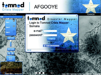
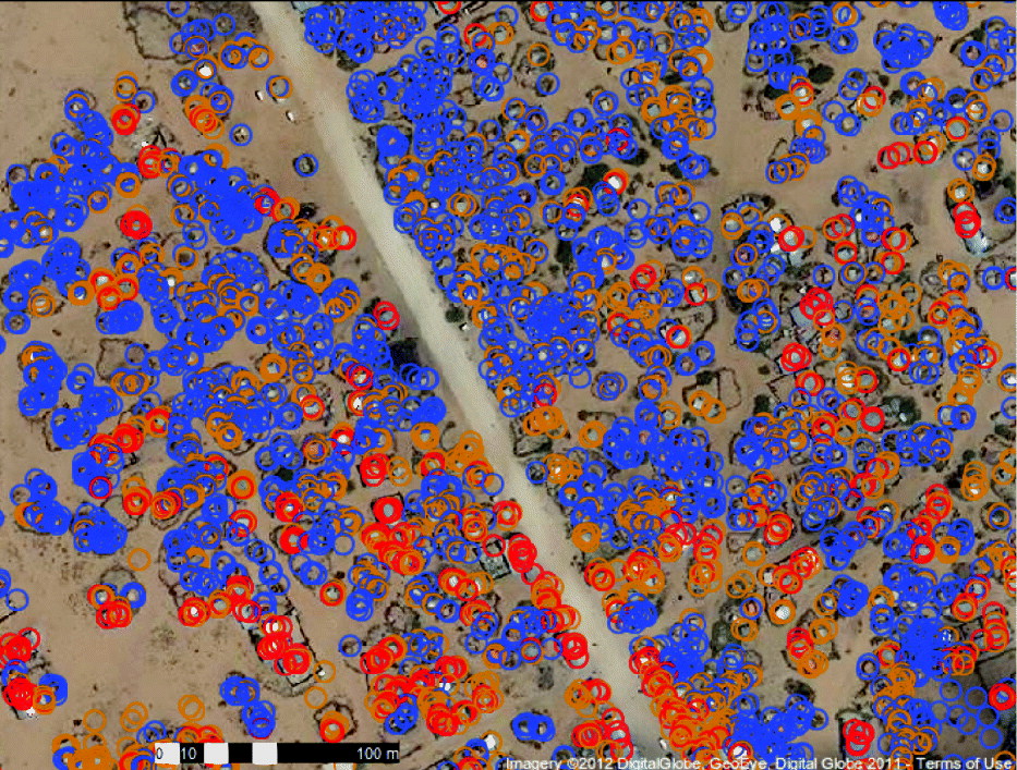
While initial conversations with the UNHCR were still taking place, the SBTF decided to launch a new team, the SBTF Satellite Imagery Analysis Team (Sat Team for short). They partnered with DigitalGlobe to acquire the relevant high-resolution satellite imagery and with Tomnod, a new start-up company that specializes in micro-tasking for satellite imagery analysis (see Figure 6). The Tomnod platform basically divides satellite imagery into a grid, that is, a series of much smaller rectangles. Each of these rectangles can then be analysed individually and tagged accordingly. The results are aggregated and collated for overall analysis. For example, a volunteer signs on to the Tomnod platform and looks for features of interest, such as an informal shelter. When such a feature is found, a volunteer simply uses the mouse and points to the feature to create a geo-tag, or marker, that represents an informal shelter (see Figure 6).
The Tomnod platform is designed to micro-task satellite imagery tagging and analysis.

The real power of micro-tasking platforms such as Tomnod, however, is that these tags can be triangulated. For example, only when three volunteers individually tag a feature as an informal shelter does that ‘data point’ get approved and shared with UNCHR. In addition, a considerable volume of user statistics can be generated to understand how individual volunteers are tagging features. This enables the Sat Team to understand where and when volunteers are making systematic errors in their tagging.
To test out this new SBTF team and the Tomnod platform, the Sat Team organized a simple trial run in September 2011. An arbitrary type of shelter was selected and a simple feature-key with rule-set was developed. Feature-keys provide visual examples of what features are being sought out, while rule-sets describe the appearance of the said features using text. Within a week, SBTF volunteers analysed close to 10,000 satellite images and tagged almost 4,000 features that resembled the feature-type described in the feature-key and rule-set. Using Tomnod's triangulation feature resulted in 1,423 final tags.Footnote 44 The trial run provided the SBTF and Tomnod with a long list of lessons learned that needed to be internalized before any official activation of the SBTF by UNHCR in Geneva.
In October 2011, UNHCR formally partnered with the SBTF to co-develop a formal feature-key and rule-set. One month later, UNHCR activated the network to run a comprehensive analysis of satellite imagery for a larger area in Somalia. In addition to turning to the network's more than 700 volunteers, the SBTF Sat Team also reached out to the American Society for Photogrammetry and Remote Sensing (ASPRS), a network of graduate students studying satellite imagery analysis. The result? Over a quarter of a million features were tagged by 168 volunteers after processing nearly 4,000 satellite images in just 120 hours.Footnote 45 In doing so, volunteers closely scrutinized a space covering more than 100 square kilometres. Compare this to the more than thirty days that the two UNHCR staff took in 2010 to carry out similar analysis. However, instead of 4 eyes analysing the imagery, 336 eyes did so, the results of which could also be triangulated for quality control purposes. UNCHR and Tomnod recently completed the analysis of the data.
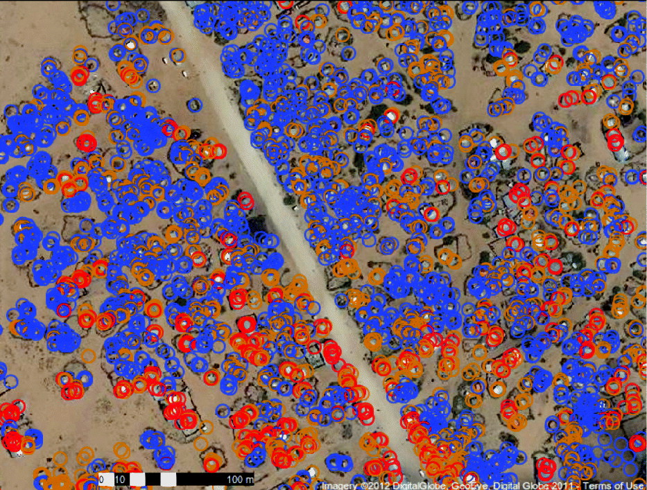
Using Tomnod's built-in quality control mechanisms, a total of approximately 47,500 shelters were triangulated and shared with UNHCR via a dedicated Ushahidi platform (see Figure 7). UNHCR staff are currently analysing these results and comparing them with other IDP population estimates for the area. In addition, the European Commission's Joint Research Centre are also running their automated shelter detection algorithms on the same satellite imagery in order to estimate the IDP population in the Afgooye Corridor, for the purposes of cross-triangulation with the crowdsourced tagging. In the future, the hope is that crowdsourcing and automated methods can be combined to yield faster and more reliable results.
Shelters tagged by SBTF volunteers along with Tomnod's resulting triangulation.
The project was subsequently presented to UNHCR's Deputy High Commissioner in Geneva at the end of 2011. He applauded the initiative and had this to say in an exclusive video addressed to SBTF volunteers:
I'm Alex Aleinikoff, the Deputy High Commissioner of UNHCR and I've just learned about the wonderful work done by the Standby Task Force which has permitted us to count shelters in the Afgooye Corridor in Somalia through the volunteer work of folks like you around the world. This is such a wonderful project for us; it provides enormously important information to UNHCR and helps to create a worldwide virtual community involved in helping refugees and internally displaced people. So I salute you for your work and for the time you have devoted to this project, it's important to us, it's important to people who have been forced from their homes and who are trying to create a new home and a new beginning, thank you.Footnote 46
Aleinikoff expressed a strong interest in seeing this type of collaboration continue. He values the collaboration not just on the information management side but equally in terms of community engagement with UNCHR's work. In other words, he was particularly interested in the impact of this initiative on the wider, public knowledge of UNCHR's programmes and the crisis itself in Somalia. As a result of the crowdsourcing, more SBTF volunteers and students from the ASPRS are now more informed both about UNHCR's work in Somalia and also about the unfolding crisis. In addition, most volunteers acquired new skills (in remote-sensing analysis) and have expressed an interest in future collaboration with the UNHCR around the world.
The UNCHR partnership with the SBTF demonstrated that volunteers could do more than simply map information drawn from social media, as on the Libya Crisis Map. While this was just a pilot project, it provided a proof of concept: namely that volunteers using new technologies such as the Tomnod platform can also support humanitarian organizations by rapidly analysing satellite imagery. In the future, UNHCR hopes actively to draw on volunteer networks such as the SBTF to support their operations in the field. At this point, this type of approach is still in research and development stage. Indeed, as with all the innovative uses of technologies described in this article, the innovation tends to come from volunteer networks in the form of do-it-yourself projects. Over time, as more of these DIY initiatives become part of formal humanitarian organizations, the technologies that make them possible are likely to become mainstream within the humanitarian sector.
Lessons learned and the big picture
The purpose of this article was to demonstrate the impact that new information and communication technologies are having on the humanitarian sector. The analysis has focused specifically on new crisis-mapping technologies and digital volunteer networks that have surfaced in just the last two years. Each of the four case studies highlighted the impact of new technologies and volunteer networks on the humanitarian sector. More importantly, they demonstrated that crisis-affected communities are increasingly becoming the source of digital information, and thus critical nodes of information following a crisis. This radical shift in information source and volume is set to make a significant shift in the way that humanitarian organizations operate.
These innovations, however, are not devoid of serious challenges. What are the ethical and security implications of mapping user-generated content in a conflict zone? What legal liabilities might volunteers face as a result of their efforts? What data protection protocols should be adopted to guide the work of crisis-mapping projects worldwide? How does one verify crowdsourced information in near real time to ensure that the resulting map is accurate? How can volunteer engagement be maintained and better co-ordinated? Do humanitarian organizations even have the capacity and resources to respond to information added to crisis maps?
A recent review of data protection standards developed by humanitarian organizations reveals absolutely no reference to social media. The SBTF is thus collaborating with the ICRC to update existing data protection standards to account for the fact that (1) global volunteer networks are becoming more engaged in crisis response (albeit virtually), and (2) crisis information is increasingly generated by disaster-affected populations. In terms of legal liabilities, the SBTF is working closely with pro bono lawyers from several firms to understand better the potential risks of volunteer engagement. Equally importantly, SBTF's legal partners are drafting disclaimers and other important legal documents to guide and protect the work of skilled volunteers. As for ethical and security implications, the SBTF is carrying out a full internal review of its operations and also reaching out to experts for guidance in this process.
It is worth emphasizing that the majority of crisis maps are actually not launched by humanitarian organizations or digital volunteer networks. Indeed, because new ICTs are freer and easier to use than ever, ordinary individuals are launching their own maps. The Ushahidi platform itself has been used in over 140 countries in just a few years, and crisis-affected communities are already launching their own crisis maps; these too will lead to questions around ethics, security, liability, and data protection. While the SBTF and other partners may be able to navigate these issues and produce appropriate guidelines to inform crisis mapping, these cannot be globally enforced or easily disseminated to every new user of a crisis map. As noted in a recent exchange on the Crisis Mappers Network,
Crisis Mapping is not simply a technological shift, it is also a process of rapid decentralization of power. With extremely low barriers to entry, many new entrants are appearing in the fields of emergency and disaster response. They are ignoring the traditional hierarchies, because the new entrants perceive that there is something that they can do which benefits others.Footnote 47
Another challenge revolves around the use of crowdsourcing as a methodology to collect crisis information, namely, how to ensure that said information is trustworthy and reliable? Many crisis-mapping projects map information found on Twitter, YouTube, Flickr, Facebook, and so on. Meanwhile, crisis-mapping platforms in Sudan, Egypt, and Russia have all been swamped with propaganda and misinformation, for example. More often than not, however, local groups are easily able to detect this propaganda. But there is no doubt that repressive regimes and other actors are becoming increasingly sophisticated at spreading misinformation. To cope with this challenge, the SBTF has set up a dedicated Verification Team, along with detailed guidelines on how to verify crowdsourced information from social media.Footnote 48 Evidently, humanitarians are not the only ones facing this challenge: journalists are increasingly confronted with the need to vet and verify crowdsourced information. This explains why many of the verification guidelines used by the SBTF come from best practices produced by the BBC and National Public Radio (NPR).
It is worth emphasizing that crowdsourcing is only one of many methodologies that can and are being used to collect information. A variant on crowdsourcing, for example, is ‘bounded crowdsourcing’, which is more formally referred to in statistics as ‘snowball sampling’.Footnote 49 With bounded crowdsourcing, one begins with a small network of trusted individuals who are the ones tasked with collecting relevant information. These individuals then invite two or three additional individuals whom they trust and can fully vouch for; and so on and so forth. In this way, the information collection network can continue to grow while remaining bounded by trust.Footnote 50 Of course, representative sampling can also be used to collect and map crisis information.Footnote 51 Finally, it is important to remember that emergency numbers such as 911 in the US or 999 in the UK are actually crowdsourcing platforms; and they clearly work.Footnote 52 So crowdsourcing is not new per se.
Another challenge has to do with the management of digital volunteer networks such as the SBTF. While the SBTF has set up co-ordinating structures and workflows, maintaining volunteer engagement is an ongoing challenge. Approximately 20% of volunteers tend to be available at any given time, and it is often the same volunteers who repeatedly offer their services. This leads to potential burn-out among digital volunteers, which explains why the SBTF recently launched its Psychological Support Team. Still, activating the other 80% of volunteers continues to be a challenge. In addition, because volunteer networks such as the SBTF are open networks – meaning that anyone is welcome to join – this has can have negative consequences, such as the presence of rogue volunteers. The SBTF has been fortunate enough only to have 4 rogue volunteers out of 800 (thus, only 0.005% of volunteers have turned out to be problematic). Nevertheless, these individuals can wreak havoc and seriously undermine morale. As a result of these difficult experiences, the SBTF has set up a Human Resource Team and clear protocols on how to deal with troubled volunteers.
The fact that both volunteer networks and crisis-affected communities are becoming increasingly digital presents another major challenge to the humanitarian community. While new live crisis maps and crowdsourcing platforms are constantly being launched, these technologies do not necessarily increase the humanitarian community's already overstretched ability to respond in emergencies. This gap can turn out to be dangerous for responders. A recent survey by the American Red Cross shows that the vast majority of those surveyed believe that national response organizations should regularly monitor social media sites in order to respond promptly.Footnote 53 In fact, more than one-third of those polled said that they would expect help to arrive in less than an hour after posting a need online during a crisis. There is thus clearly increasing pressure for professional humanitarian organizations to be more responsive.
The most important untold story in the response to Haiti has to do with the hundreds of Haitian volunteers who translated incoming text messages from the 4636 SMS short code. Several dozens of these volunteers were actively involved in responding to these text messages directly – even before the messages were added to the public Haiti crisis map. Haitians used their own networks in the diaspora and on the ground in Haiti to get help to those who texted in urgent requests for water, shelter, food, and medication. While not always possible and depending on context, partnering more closely with diasporas may alleviate some of the burden being placed on official humanitarian response organizations.
In other words, one way to cope with this increasing demand might be to take a more decentralized, bottom-up approach. Take the example of the Russia help map discussed earlier. This was a distributed, grassroots response to a major disaster. Providing platforms for citizens to organize themselves during a time of crisis may very well be the way forward. Recall that first responders are by definition the crisis-affected communities. One is more likely to get help from a neighbour than a search and rescue team in the immediate aftermath of an earthquake, for example. In other words, affected communities already help themselves out where and when they can. Put differently, many of the needs arising after a disaster can be met and responded to locally, and disaster-affected populations already self-organize following a crisis. You do not need ten years of work experience with the UN in Darfur to pull your neighbour out of the rubble. It is local communities rather than humanitarian professionals who save the most lives following a disaster.Footnote 54 In fact, estimates suggest that, ‘no more than 10% of survival in emergencies can be attributed to external sources of relief aid’.Footnote 55
The question, therefore, is how these populations can make better use of new information technologies to support their immediate self-organized response efforts, as in the Russian help map example. How can new technologies be used to help crowdsource humanitarian response?Footnote 56 The company LinkedIn is taking innovative steps to enable the matching of volunteers with various needs. They recently added a ‘Volunteer and causes’ field to their member profile page, which is now available to 150 million LinkedIn users worldwide.Footnote 57 Sparked.com is yet another group engaged in matching volunteers with needs. The company is the world's first micro-volunteering network, sending challenges to registered volunteers that are targeted to their unique skill set and the causes that they are most passionate about.Footnote 58 It is not farfetched to envisage how these technologies could be repurposed or simply applied to facilitate and streamline volunteer management following a disaster. Indeed, researchers at the University of Queensland in Australia have already developed a new smartphone application to help mobilize and co-ordinate volunteer efforts during and following major disasters.Footnote 59 The application not only provides information on preparedness but also gives real-time updates on volunteering opportunities by local area. For example, volunteers can register for a variety of tasks, including community response to extreme weather events.
Where is the humanitarian sector heading as far as new ICTs are concerned? Perhaps two very new initiatives may help answer that question and pave the way forward. The first is the Digital Humanitarian Network, a dedicated online platform designed to facilitate collaboration between professional humanitarian organizations and informal digital volunteer networks such as the SBTF. Digital Humanitarians is a ‘network of networks’ and a one-stop shop for humanitarian organizations seeking support from highly skilled volunteer groups. The second example is the American Red Cross's Digital Operations Center, launched in partnership with Dell. This is the
first social media-based operation devoted to humanitarian relief, demonstrating the growing importance of social media in emergency situations. The Red Cross also announced a Digital Volunteer program to help respond to questions from and provide information to the public during disasters.Footnote 60
The two initiatives may indeed be a sign of things to come, and if successful will further demonstrate the very real and important impact that new information and communication technologies can have on the humanitarian sector.