INTRODUCTION
As an integral part of the global climate system, the Asian monsoon system provides heat and precipitation that directly affect the livelihood of nearly half of the world's population. Thus, knowledge of their spatiotemporal variation is essential for decision making and management in the context of sustainable development (WCRP, 2009; Wang et al., Reference Wang, Wang, Cheng, Fasullo, Guo, Kiefer and Liu2014b; An et al., Reference An, Wu, Li, Sun, Liu, Zhou and Cai2015). The East Asian monsoon, a unique subtropical–extratropical monsoon system that can extend poleward to ~50°N latitude, has been established since at least the early Miocene (Sun and Wang, Reference Sun and Wang2005; Guo et al., Reference Guo, Sun, Zhang, Peng, Xiao, Ge and Hao2008). As one half of the East Asian monsoon, the East Asian winter monsoon (EAWM) was initiated by the development of the Siberian high, and it transmits high-latitude climate signals to subtropical and tropical regions, resulting in a strong cold and dry northerly circulation over East Asia, thereby affecting a quarter of the Northern Hemisphere (Liu, Reference Liu1985; Chang, Reference Chang2004; Wang et al., Reference Wang, Wang, Cheng, Fasullo, Guo, Kiefer and Liu2017).
Since the 1990s, the evolution of the EAWM since the Pliocene, on both tectonic and orbital time scales, has been reconstructed using proxy indicators from the Chinese Loess Plateau and the South China Sea (mainly drill cores obtained during ODP Leg 184) (Fig. 1a). Records of grain size distributions and dust flux of the windblown loess-paleosol and red clay sections in the Chinese Loess Plateau are usually used to reconstruct the variability of the EAWM (Liu and Ding, Reference Liu and Ding1993; Ding et al., Reference Ding, Yu, Rutter and Liu1994, Reference Ding, Liu, Rutter, Yu, Guo and Zhu1995, Reference Ding, Derbyshire, Yang, Yu, Xiong and Liu2002; Lu et al., Reference Lu, van Huissteden, Zhou, Vandenberghe, Liu and An2000). In addition, the mean grain size of quartz particles (MGSQ) in loess-paleosol and red clay sequences has been recognized as a reliable proxy for reconstructing variations in EAWM intensity, due to the stability of quartz during post-depositional modification, weathering, and pedogenesis, as well as its relatively stable provenance (Xiao et al., Reference Xiao, Porter, An, Kumai and Yoshikawa1995; Sun et al., Reference Sun, Lu and An2000, Reference Sun, Lu and An2006b; Amit et al., Reference Amit, Enzel, Mushkin, Gillespie, Batbaatar, Crouvi, Vandenberghe and An2014). Several geochemical indicators with high sensitivity to weathering and pedogenesis, such as the Zr/Rb ratio and Sr and Nd isotopes, have also been used to reconstruct EAWM variations (Liu et al., Reference Liu, Chen, Ji and Chen2004; Chen et al., Reference Chen, Chen, Liu, Ji, Balsam, Sun and Lu2006; Wang et al., Reference Wang, Yang, Chen, Zhang and Rao2007). Both the strength and duration of the EAWM increased during glacial periods, which resulted in enhanced upwelling and mixing that supplied increased quantities of nutrients to the surface of the East Asian marginal seas. Therefore, enhanced biological productivity during glaciations is revealed by various proxies from the northern South China Sea (Tian et al., Reference Tian, Wang, Chen and Cheng2005; Wan et al., Reference Wan, Li, Clift and Stuut2007; Zhao et al., Reference Zhao, Wang, Tian, Li, Wang and Li2009). In the northern South China Sea, records of clay minerals (Wan et al., Reference Wan, Li, Clift and Stuut2007) and planktonic foraminifera (Li et al., Reference Li, Wang, Huang, Li, Jian, Zhao, Su and Wang2004) from ODP Site 1146 have revealed enhancement of the EAWM between 3.1 and 2 Ma.
(a) Location of Xingkai Basin (the area enclosed by the red line), loess sections (JB, Jingbian section; ZJC, Zhaojiachuan section; LT, Lingtai section; CF, loess sections near Chifeng City, Inner Mongolia), and marine sediment cores drilled during Ocean Drilling Program Leg 184. Orange shading indicates the Chinese Loess Plateau; white arrows indicate East Asian winter monsoon trajectories and extent. The base maps is from Google Earth. Figure 1. (b) The location of drilling core XK12 and stratotypes mentioned in the text. The area enclosed by the red line is the Xingkai Basin, and the area enclosed by the purple line is the middle and upper reaches of the Suifen River. Gray dashed lines are fault belts: 1, Jiamusi-Yitong fault belt; 2, Fushun-Mishan fault belt; 3, middle Sikhote-Alin fault belt. The red star is the location of drilling core XK12, and blue dots are the locations of Neogene stratotypes. N1usf, Ust-Suifunskaya Fm.; N2sf, Shufanskaya Fm.; N1−2xlz, Xialiangzi Fm.; N1−2fj, Fujin Fm. Cyan dots indicate the locations of lower Pleistocene stratotypes. Q11 an, Annenskaya Fm.; Q21 sf, Suifunskaya Fm.; Q1al, alluvial sediment member in Xingkaihu Plain; Q1sb, Suibin Fm. Magenta dots are locations of middle Pleistocene stratotypes. Q2nj, Nongjiang Fm.; Q2xkh, Xingkaihu Fm.; Q2dv, lacustrine sediment member, which is the dividing range between the Xingkai Basin and the modern Suifen River. The orange dot labeled “Q3−4hg” is the Hugang Fm. The base map is from Google Earth. (For interpretation of the references to color in this figure legend, the reader is referred to the web version of this article.)

Variations of the East Asian monsoon since the late Pliocene are closely linked to global glacial–interglacial cycles, and therefore proxies of East Asian monsoon intensity from the Chinese Loess Plateau have been correlated to the global marine δ18O record to provide a chronostratigraphic framework (Liu, Reference Liu1985; Kukla et al., Reference Kukla, Heller, Ming, Chun, Sheng and Sheng1988; Maher and Thompson, Reference Maher and Thompson1992; Liu and Ding, Reference Liu and Ding1993). Orbital parameters, especially obliquity, which influences summer insolation in high-latitude regions, drive global ice volume fluctuations and have been recognized as the predominant forcing factor of changes in the EAWM (Liu and Ding, Reference Liu and Ding1993, Reference Liu and Ding1998; Ding et al., Reference Ding, Derbyshire, Yang, Yu, Xiong and Liu2002; Sun et al., Reference Sun, Clemens, An and Yu2006a). In addition, a low-latitude EAWM record based on surface and subsurface temperature differences in the northern South China Sea indicated that the mean state of the super El Niño–Southern Oscillation strongly modulated EAWM variability during 2.8–1.2 Ma, while the intensity of Northern Hemisphere glaciation (NHG) was not sufficient to dominate EAWM variations; this changed after 0.9 Ma (Li et al., Reference Li, Zhao and Tian2017). Various driving mechanisms of the EAWM have been inferred from records from different domains of the monsoon region. A high-resolution EAWM record spanning the late Neogene from elsewhere in East Asia is needed to clarify the interactions between EAWM variations and other components of the global climate system, especially in northeast Asia, where the climate is directly affected by the EAWM.
Well-preserved long-term terrestrial paleoenvironmental archives are scarce in northeast Asia. Loess deposits surrounding the Horqin and Otindag Deserts in Chifeng, northeast China, have been used to reconstruct the climatic evolution of the region since ~1.22 Ma (Zeng et al., Reference Zeng, Lu, Yi, Li, Lv, Zhang, Xu, Wu, Feng and Cui2016) (Fig. 1a). In addition, thick sequences of alluvial and lacustrine deposits have accumulated in the sedimentary basins of northeast Asia, and sedimentary sections of different ages can be used to reconstruct East Asian monsoon behavior. Fossil plant remains of Calabrian age preserved in the Pavlovskoe brown coal field in the Russian Far East are characterized by taxonomic diversity. Studies using multiple techniques have been conducted on various paleobotanical organ types and have revealed the effects of the East Asian monsoon on the climate of the region during the last 200 ka of the Calabrian (Bondarenko et al., Reference Bondarenko, Blokhina and Utescher2013). Cenozoic continental deposits are well exposed in open cast mines used for brown coal exploitation in basins in the southern part of the Russian Far East. Analysis of 14 different floral horizons has been conducted in order to reconstruct climate change during intervals from the middle Eocene to the early Pleistocene (Utescher et al., Reference Utescher, Bondarenko and Mosbrugger2015). Unfortunately, however, no long, continuous record has yet been obtained of the evolution of the East Asian monsoon in high-latitude northeast Asia.
Xingkai Basin is located in northeast Asia and is directly influenced by the Siberian high that promotes the equatorward development of a strong EAWM (Sun et al., Reference Sun, Shen, Yu, Long, Zhang, Liu and Chen2018) (Fig. 1). It has subsided substantially since its initial formation in the early Cenozoic (Korotkii et al., Reference Korotkii, Grebennikova, Karaulova and Belyanina2007), which has favored the preservation of a continuous, rapidly accumulated sedimentary sequence well suited for reconstructing the evolution and variability of the EAWM. In this study, we present pollen, lithostratigraphic, and paleomagnetic evidence from a 328.58-m-long core of lacustrine–alluvial sediments drilled in the Xingkai Basin. We use the results to reconstruct the evolution of the EAWM since the Pliocene, with the aim of providing new insights into its forcing mechanisms.
STUDY AREA
Xingkai Basin, in the upper and middle reaches of the Ussuri River, is the southernmost part of the Heilongjiang (Amur) River system and has an area of ~105,000 km2. Xingkaihu Plain, comprising about one fifth of the area, is a flat alluvial–lacustrine plain located in the north of the basin. Xingkaihu Plain is surrounded by mountains: the Sikhote-Alin to the east, the Wanda Mountains to the north, and the Changbai Mountains to the west. Lake Xingkai (Khanka) is a major tributary of the Ussuri River, located in the southwest part of Xingkaihu Plain. The surface area is 4200 km2, the catchment area is ~20,400 km2, the average water depth is ~4.5 m, the maximum water depth is ~10 m, and the elevation of the modern lake level is 69 m above sea level (m asl) (Long et al., Reference Long, Shen, Wang, Gao and Frechen2015; Sun et al., Reference Sun, Shen, Yu, Long, Zhang, Liu and Chen2018). The only outflow is the Songacha River in the eastern part of the lake basin (Fig. 1).
Modern climate and vegetation
The modern climate of Xingkai Basin is mainly determined by the East Asian summer and winter monsoon circulation. The annual temperature ranges from 2°C to 5°C, the mean temperature of the warmest month (July) is 22°C, and the mean temperature of the coldest month (January) is about −20°C. Rainfall occurs mainly in summer, with an annual total of ~540 mm (Sun et al., Reference Sun, Shen, Yu, Long, Zhang, Liu and Chen2018).
The modern vegetation of Xingkai Basin consists of meadows, bogs, and forests in almost equal proportions. Meadows are widespread in the poorly drained parts of Xingkaihu Plain and in the river valleys, and bogs occur in floodplain and lakeshore areas. The main forest type in the lowlands is Mongolian oak (Quercus mongolica), forming pure stands or occurring in mixed broadleaf forest with Populus, Betula, Ulmus, and Fraxinus (Xia, Reference Xia1988; Kolbek et al., Reference Kolbek, Srutek and Box2003). Temperate mixed forest occurs on the mountains surrounding Xingkai Basin (40°15′–50°20′N, 126°–135°30′E); it is codominated by Pinus koraiensis and various broadleaf trees, including Quercus, Tilia, Betula, Acer, Fraxinus, Ulmus, and Populus, together with the heliophilous conifer Abies holophylla (only south of 44°N). At 600–800 m asl, the temperate communities may include the boreal dominants Picea jezoensis, Picea koraiensis, and Abies nephrolepis (Sun and Weng, Reference Sun and Weng1992; Ren and Zhang, Reference Ren and Zhang1998; Kolbek et al., Reference Kolbek, Srutek and Box2003).
Geology, Neogene and Quaternary stratigraphy
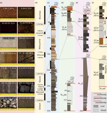
Sanjiang Plain, Xingkaihu Plain, and the upper and middle reaches of the Suifen (Razdol'naya) River, have developed in the uniform structural deformation zone of northeast Asia (Zhang et al., Reference Zhang, Guo, Zeng, Fu and Pu2015). These three depressions have undergone synchronous tectonic subsidence controlled by faults on their two sides since they came into existence in the early Cenozoic (BGMRHP, 1993; Pavlyutkin and Petrenko, Reference Pavlyutkin and Petrenko2010). As a result of river capture in the middle Pleistocene, the modern Suifen River turns to the south near Ussuriysk and flows into the Sea of Japan. Before this, the path of the paleo-Suifen River turned to the northeast to the north of Ussuriysk and crossed the modern dividing range between the middle reach of the Suifen River and Xingkai Basin, and then flowed into the Xingkai Basin, which made it an important tributary of Lake Xingkai (Belyanina et al., Reference Belyanina, Belyanin and Mityureva2009; Bondarenko et al., Reference Bondarenko, Blokhina and Utescher2013). Thus, the Ussuri River once linked the three depressions to form an integrated river system. The upper and middle reaches of the Suifen River and the mountainous areas around Xingkai Basin that are the source of modern tributaries comprised the upper reach of the Ussuri River before the middle Pleistocene. Tributaries flowed into the flat Xingkaihu Plain, and some of them merged to form a lake that constitutes the middle reach of the Ussuri River. The lower reach of the Ussuri River starts from Raohe canyon between the Xingkaihu and Sanjiang Plains and ends where the Ussuri River joins the Heilongjiang River in Sanjiang Plain. Before the middle Pleistocene, these three interconnected depressions synchronously accumulated sediments and underwent erosional deformation; thus, the regional strata of these depressions can potentially be correlated in detail. In addition, as a result of geologic surveys and mining activity over several decades in northeast China and the Russian Far East, late Cenozoic sedimentary stratotypes in the southern part of northeast Asia continent are well established (Figs. 1b and 2).
(color online) Photos of selected intervals from core XK12 (a). Standard paleomagnetic polarity column with ages (Ogg, Reference Ogg, Gradstein, Ogg, Schmitz and Ogg2012) (b). Lithostratigraphy and geomagnetic polarity column of core XK12 (c). Correlation of Neogene–Quaternary stratotypes in Xingkaihu Plain (d), Sanjiang Plain (e), and the middle reach of the paleo-Suifen River (f). The labels of stratotypes are mainly given in the caption for Fig. 1b. Other labels: βN2jd, Jidong Basalt; Q13 xyc, Xiangyangchuan Fm.; Q23 blhh, Bielahonghe Fm.; Q4, Holocene sediments. Lithologic labels: cl, clays; ss, silt sand; fs, fine sand; ms, medium sand; cs, coarse sand; pc, pebble and cobble.

The widespread Neogene system in the middle reach of the Suifen River mainly comprises the Ust-Suifunskaya and Shufanskaya Formations (Fm.), both consisting of alluvial–lacustrine sediments and basalt. The Ust-Suifunskaya Fm., which extends to the south of Xingkai Basin and the middle reach of the Suifen River, is mainly of late Miocene age and is characterized by the occurrence of the pollen of Fagus (Pavlutkin and Petrenko, Reference Pavlyutkin and Petrenko2010). The Shufanskaya Fm. developed within the middle reach of the Suifen River and has an unconformable contact with the underlying Ust-Suifunskaya Fm., which is mainly of Pliocene age. Pollen assemblages in the upper part of the formation are dominated by Pinus and Betula, with the rare occurrence of Juglans, Quercus, Fagus, Acer, and Tilia. The increasing representation of cold-tolerant forest at the expense of thermophilous trees likely reflects substantial major climatic cooling at the beginning of the Pleistocene. In addition, the upper basalt horizon of the formation has a reversed magnetic polarity and is likely derived from a volcanic eruption in the early Matuyama chron (Pavlutkin and Petrenko, Reference Pavlyutkin and Petrenko2010) (Figs. 1b and 2). This evidence indicates that Neogene alluvial–lacustrine sedimentation in the middle reach of the Suifen River continued until the end of the Pliocene.
The Xialiangzi Fm. is widely distributed in Xingkaihu Plain and consists mainly of Neogene alluvial–lacustrine sediments. The stratotype of the Xialiangzi Fm. formed in the western branch of Xingkaihu Plain (the Muling River valley), where the formation is relatively thin compared with the depocenters of the plain, and contains interbedded basalt derived from volcanic eruptions of the nearby Changbai Mountains. In the central Xingkaihu Plain, this formation is buried by Quaternary deposits, and in the western mountainous area, it is covered by the Jidong Basalt (dated to 3.36–4.09 Ma by the K-Ar method, as is the case for basalt ages referenced herein) (BGMRHP, 1993) (Figs. 1b and 2). The Fujin Fm. is the Neogene stratotype of Sanjiang Plain. This alluvial–lacustrine stratum can generally be divided into two parts: the bottom part begins with lacustrine clay and silty sand and ends with coal-bearing siltstone; and the top part is greenish-gray to gray sand, silty sand, and clay. These two Neogene formations in both the Xingkaihu and Sanjiang Plains are dated to the Miocene through Pliocene, and their pollen flora is dominated by angiosperms (BGMRHP, 1993) (Figs. 1b and 2). Comparison of the Neogene stratotypes from the three depressions linked by the paleo-Suifen River reveals the occurrence of thin sedimentary deposits in the upper reach valley, interbedded with basalt lava; and thick and continuous sedimentary deposits in the middle and lower reaches, with the absence of basalt lava. There is generally an unconformity between the Neogene alluvial–lacustrine strata and the overlying Pleistocene deposits. Deposition continued until the very end of the Pliocene, even in the upper reach of the Ussuri River.
The Quaternary system is widely developed across the whole of the three depressions and consists of mainly alluvial and lacustrine deposits. The stratigraphic contact between the Quaternary and underlying strata is a parallel unconformity. In the middle and lower reaches of the Ussuri River, namely the Xingkaihu and Sanjiang Plains, respectively, the lower Pleistocene deposits range from poorly sorted diluvial to alluvial sands and lacustrine silts and clays. The strata in Sanjiang Plain are usually thicker than those in Xingkaihu Plain. There is a fining upward of the grain size, and the thickness of the strata gradually decreases from the center to the margin of the basins. The early Pleistocene alluvial–lacustrine strata in Xingkaihu Plain are characterized by light-colored, poorly rounded vein quartz detritus. The Suibin Fm., deposited in Sanjiang Plain in the early Pleistocene, is enriched in dark-colored detritus with occasional interbeds of silt and clay. Following the termination of the deposition of the Suibin Fm., there was a transient uplift event in Sanjiang Plain, resulting in a partial paraconformity with the overlying middle Pleistocene deposits. This paraconformity horizon has been defined as the boundary between the lower and the middle Pleistocene in the Sanjiang and Xingkaihu Plains and is dated to 1.2 Ma, slightly earlier than the beginning of the Jaramillo geomagnetic event. After 1.2 Ma, the Xingkaihu Fm. and Nongjiang Fm. were deposited in the Xingkaihu and Sanjiang Plains, respectively. These two sequences of middle Pleistocene lacustrine sediments are homogeneous in lithology, which indicates the occurrence of a major stage of lake development within these two depressions during the Quaternary (BGMRHP, 1993; Qi et al., Reference Qi, Zhang, Lu, Bai and Yang2015) (Figs. 1b and 2).
In the middle reach of the Suifen River and the upper reach of the Ussuri River, the lower Pleistocene consists of two sections. The Annenskaya Fm. is characterized by brownish-red lacustrine sand and clay layers and is widespread within the southern part of Xingkai Basin; in the southern part of Xingkaihu Plain, it is overlain by early Pleistocene greenish-gray sands and clays. Its provenance is a variously colored piedmont weathering crust developed along the slopes around the southern Xingkai Basin. The Annenskaya Fm. is characterized mainly by reversed geomagnetic polarity, and therefore its age corresponds to the beginning of the Matuyama chron, that is, the Gelasian stage (Pavlutkin and Petrenko, Reference Pavlyutkin and Petrenko2010) (Figs. 1b and 2). The overlying Suifunskaya Fm. occurs in the middle reach of the Suifen River and farther north in Xingkaihu Plain. This formation has a clear erosional unconformity with the underlying Annenskaya Fm. The Suifunskaya Fm. consists of alluvial sand and pebbles derived from acidic light-colored vein quartz with notable amounts of granite and andesite debris. Based on pollen assemblages, this formation is of early Pleistocene age, possibly extending into the early stage of the middle Pleistocene (Pavlutkin and Petrenko, Reference Pavlyutkin and Petrenko2010) (Figs. 1b and 2). A recent paleomagnetic study of the Suifunskaya Fm. constrained its age to the interval between the Jaramillo and the Brunhes/Matuyama (B/M) boundary (Bondarenko et al., Reference Bondarenko, Blokhina and Utescher2013). Above the Suifunskaya Fm., dark gray clays and fine sand are present with a conformable contact. This lacustrine sedimentary sequence in the middle reach of the Suifen River and southern Xingkai Basin is considered to be of middle Pleistocene age.
In summary, before 1.2 Ma, when alluvial sediments began to be widely deposited in the Xingkaihu and Sanjiang Plains (i.e., in the middle and lower reaches of the Ussuri River, respectively), proximal sediments began to be intermittently deposited in the middle reach of the Suifen River (i.e., the upper valley of the Ussuri River). After 1.2 Ma, continuous deposition of lacustrine sediments started in the Xingkaihu and Sanjiang Plains, while the middle reach of the Suifen River started to accumulate alluvial deposits. After the B/M boundary, continuous accumulation of lacustrine sediments with identical color and lithologic characteristics began in all three depressions. This homogeneous lacustrine sedimentation represents the principal stage of lake development in the Ussuri River catchment during the Quaternary. However, shortly afterward, lacustrine sedimentation ceased abruptly and almost simultaneously. The unconformity on the top of the widespread lacustrine strata marks the termination of middle Pleistocene sedimentation throughout the entire Ussuri River catchment, and subsequently no sizable stable sedimentary environment existed in the middle and lower reaches of the Ussuri River.
In the late Pleistocene, two series of terraces formed together with Lake Xingkai and major rivers in the Sanjiang and Xingkaihu plains. Terrace II, named the Xiangyangchuan Fm., formed in the early stage of the late Pleistocene; and terrace I, named the Bielahonghe Fm., formed in the late stage of the late Pleistocene. The sediments in floodplains, marshland, and paleochannels comprise the major part of the Holocene series in the Sanjiang and Xingkaihu Plains (BGMRHP, 1993). Notably, the northern margin of paleo-Lake Xingkai is delimited by four prominent sand ridges on the broad coastal plain; they are interpreted as representing four distinct periods of lake lowstand that caused beach exposure and provided a more extended sand source for foredune formation around Lake Xingkai (Qiu et al., Reference Qiu, Wan and Wang1988; Long and Shen, Reference Long and Shen2015). The sandy ridges are mainly composed of well-sorted brown to brownish-red eolian sand with distinct cross-bedding structures, and are defined as the late Pleistocene and Holocene series, termed the Hugang Fm. (BGMRHP, 1993; Long and Shen, Reference Long and Shen2015) (Figs. 1b and 2). The Suifen River was separated from the upper reach of the Ussuri River in the middle Pleistocene (Bondarenko et al., Reference Bondarenko, Blokhina and Utescher2013), which was likely the result of neotectonic activity and river capture, and subsequently the middle Pleistocene lacustrine strata acted as a dividing range between them.
MATERIALS AND METHODS
Drill core XK12
Core XK12 (45°18′48.90″N, 132°34′57.40″E, 75 m asl) was drilled on the sandy beach ridge of the northern lakeshore (Fig. 1). The use of internal plastic tubing during drilling minimized twisting and distortion of the core (Shen et al., Reference Shen, Wang, Wang, Qiang, Xiao and Xiao2010). The total depth of the core is 328.58 m, with a recovery of up to 90.8%.
The sedimentary sequence recovered in core XK12 can be divided into three parts, including two normal sedimentary cycles. The top 0–5.10 m consists of brown, brownish-red, and rusty well-sorted and well-rounded eolian sands with distinct cross-bedding structures. The middle part, 5.10–167.23 m is a normal sedimentary cycle. The lacustrine interval ranges from 5.10 to 59.15 m and consists of dark clays and silty sand, with thin interbeds of fine sand. The interval from 59.15 to 149.61 m is mainly alluvial sediments; from 75.60 to 99.75 m, is homogeneous light-colored fine sand; and the remaining strata are mainly variously colored fine and silty sands. Notably, the interval of 129.81–136.85 m is a clay deposit, and the lower part from 149.61 to 167.23 m consists of diluvial deposits of poorly sorted light-gray coarse sand with a silty matrix and occasional pebbles. The bottom part, 167.23–328.58 m consists of another normal sedimentary cycle. The top interval, 167.23–197.09 m, consists of gray to greenish-gray lacustrine clays and silty sand; the middle interval, from 197.09 to 270.57 m, consists of diluvial and alluvial layers, with clay layers from 207.90 to 210.28 m and 257.11 to 264.25 m, and a riverbed pebble and cobble horizon at 265.30–270.57 m. The remaining interval, 270.57–328.58 m, is gray to greenish-gray medium sand with a relatively uniform color and lithology (Fig. 2).
Pollen analysis
A total of 1164 pollen samples were collected at an average interval of 20 cm in the upper 200 m, and at an average interval of 40 cm in the lower part. The samples were processed following standard procedures (Moore et al., Reference Moore, Webb and Collison1991): approximately 1–2 g of sediment was digested with 10% HCl and 40% HF to remove carbonate and SiO2, respectively, after which the sample was passed through a 7 μm mesh sieve. Tablets containing a known quantity of Lycopodium spores were added to each sample to determine pollen concentrations. Pollen identification and counting were performed using a Leitz optical microscope. The analyses were completed at Zihua Biotechnology in Shijiazhuang, China. The results are expressed as both percentages and concentrations. The pollen percentages of terrestrial plants (trees, shrubs, and herbs) were calculated based on a sum of terrestrial pollen, while the percentages of aquatics, fern spores, and algae are based on the sum of total pollen and spores. The pollen percentage diagram of selected pollen taxa and genera was plotted using Tilia Software (Grimm, Reference Grimm2011). The zonation of pollen assemblages was defined to six zones (1–6) using the constrained incremental sum-of-squares cluster analysis (CONISS) (Grimm, Reference Grimm1987) based on the stratigraphic distributions of all the encountered pollen taxa, with 1, 4 and 6 subdivided into three distinct subzones (Supplementary Fig. S1).
Paleomagnetic measurements
A total of 1321 orientated cubic samples (2 × 2 × 2 cm) were selected at intervals of 10–30 cm from core XK12 for paleomagnetic measurements. Magnetizations were measured using a 2G-755R cryogenic superconducting magnetometer housed in a magnetically shielded space (<150 nT) at the Institute of Earth Environment, Chinese Academy of Sciences. All samples were progressively demagnetized at fields up to 80 mT at 2–10 mT increments. Alternating-field demagnetization results were evaluated using orthogonal vector endpoint projection (Zijderveld, Reference Zijderveld, Collinson, Creer and Runcorn1967). The vector directions of the characteristic remanent magnetization (ChRM) component were calculated using principal components analysis (Kirschvink, Reference Kirschvink1980), in which the ChRM component passes through the origin and is defined by a minimum of four consecutive demagnetization steps. ChRM components with a maximum angular deviation (MAD) >15° or absolute inclination >70° or <20° were rejected. A total of 379 samples produced valid demagnetization results. The results are presented in Supplementary Table S1, the orthogonal vector endpoint projection and intensity evolution plots for demagnetization of representative samples are presented in Supplementary Fig. S2. The vector directions determined from the ChRM directions were used to define a geomagnetic polarity sequence. Only the results from five continuous intervals of clay-rich sediments were used to construct the magnetostratigraphy; this was because of the possibility of loose sandy sediments being disturbed during drilling, core splitting, and sampling. In addition, there were limited data available from core sections with a high sand content (Fig. 3).
Lithology, paleomagnetic polarity sequence, pollen spectra diagram, and integrated pollen index (green curve) for core XK12. (For interpretation of the references to color in this figure legend, the reader is referred to the web version of this article.)

RESULTS
Lithostratigraphic correlation
Xingkaihu Plain was directly linked with Sanjiang Plain and the Suifen River catchment as a result of the development of the Ussuri River system. Since their formation, the subsidence and deformation of these three depressions has been controlled by fault belts belonging to a uniform tectonic system. Therefore, their sedimentary strata are readily correlated, which provides the basis for establishing an initial chronostratigraphic framework for core XK12.
Core XK12 was drilled on a sandy beach ridge that constitutes the northern shore of modern Lake Xingkai. The top 5.10 m belongs to the Hugang Fm., characterized by bright-colored and well-sorted eolian sands with well-rounded grains. This section can be divided into the Dahugang and Taiyanggang horizons at the top and bottom, respectively (BGMRHP, 1993) (Fig. 2). Radiocarbon dates from human bones from an ancient tomb excavated in Dahugang (ATHP, 1979) and optically stimulated luminescence dating results from Taiyanggang (Qiu et al., Reference Qiu, Wan, Li and Wang2007) indicate that this part of core XK12 is of late Pleistocene to Holocene age. There is a distinct paraconformity between the eolian deposit and the underlying lacustrine sediments.
Dark-gray lacustrine clays and silty sand are continuously present below 5.10 m. The paraconformity horizon at the top of the lacustrine sediments can be correlated with the top of the middle Pleistocene Xingkaihu Fm. and the Nongjiang Fm. and with the surface of the dividing range between the Xingkai Basin and the Suifen River catchment. The paleomagnetic results reveal a transition from normal to reversed polarity at 25.00 m. Because the B/M boundary between dark-gray lacustrine sediments and the light-colored Suifunskaya Fm. marks the boundary between the early and middle Pleistocene, we assign the interval of 5.10–25.00 m of core XK12 to the middle Pleistocene (Fig. 2).
According to the paleomagnetic results of the upper lacustrine section, the end boundary of the Jaramillo event occurs at a depth of 51.40 m. The base of the lacustrine section at 59.15 m corresponds approximately to the bottom of the Suifunskaya Fm. in the middle reach of the Suifen River, which corresponds approximately to the beginning of the Jaramillo event. The alluvial and diluvial sands within the interval of 75.60–167.23 m are coeval with early Pleistocene alluvial deposits in Xingkaihu Plain and the Suibin Fm. in Sanjiang Plain. The lower variously colored sediments are likely equivalent to the Annenskaya Fm. in the upper reach of the Ussuri River. The interval of lacustrine sediments from 129.81 to 136.85 m, with a normal polarity, may have been deposited during the Olduvai event. Therefore, the pronounced paraconformity at 167.23 m in core XK12 can be determined to be the base of the Quaternary (Fig. 2).
Although there are no continuous long-term Neogene stratotypes established in Xingkai Basin, the Shufanskaya Fm. in the middle reach of the Suifen River provides comparable information about sedimentation at the end of the Pliocene (Pavlutkin and Petrenko, Reference Pavlyutkin and Petrenko2010). The upper basalt horizon of the Shufanskaya Fm. has a reversed geomagnetic polarity and is derived from a volcanic eruption at the beginning of the Matuyama chron. The underlying lacustrine horizon would have been deposited not much earlier than the end of the Pliocene. The three depressions were closely linked by the development of the Ussuri River system, and consequently, the lacustrine horizon deposited in the middle reach of the Suifen River (upper reach of the Ussuri River) can be correlated with the lacustrine horizons in the middle and lower reaches of the Ussuri River. Thus, we propose that this lacustrine horizon of the Shufanskaya Fm. can be correlated with the interval of lacustrine sediments from 167.23 to 197.09 m in core XK12 and also with the top part of the Fujin Fm. in Sanjiang Plain. Therefore, the lower normal sedimentary cycle in core XK12 continued until the end of the Pliocene. Furthermore, the paleomagnetic results for this lacustrine part of core XK12 reveal a transition from normal to reversed polarity at 170.90 m, which is probably the Matuyama/Gauss (M/G) boundary (Figs. 2 and 3). From 170.90 m to the bottom of the core, there is a continuous sequence of alluvial and diluvial sands, corresponding to the upper sandy horizon of the Fujin Fm. According to the mean sedimentation rate of ~10 cm/ka estimated for the upper part of core XK12 and the lower Pleistocene series of Sanjiang Plain (Qi et al., Reference Qi, Zhang, Lu, Bai and Yang2015), the bottom of core XK12 extends roughly to the boundary between the upper and lower Pliocene. The clay horizon at 207.90–210.28 m has a normal polarity and was likely deposited in the later part of the Gauss chron. The other clay horizon, at 257.11–264.25 m, is of reversed polarity and may correspond to the Kaena or Mammoth events.
Integrated pollen index of the EAWM
Xingkai Basin is a semiclosed basin surrounded by mountains with altitudes of 300–1800 m. Rivers supply sediment including pollen from different altitudes and transport directions (Fig. 1b). Wind dispersal is another agent that transports pollen into the plain and results in pollen mixture within the basin. But pollen transported into the basin by wind might be rare because of the high mountains surrounding the basin. Thus, the pollen assemblages from core XK12 are an integrated record of changes in the vegetational composition of the entire Xingkai Basin. Temperate mixed forest has been the major forest type in the Xingkai Basin since the Oligocene (Pavlyutkin, Reference Pavlyutkin2015). The East Asian monsoon system, which has directly influenced the Xingkai Basin, was established in the early Miocene (Guo et al., Reference Guo, Sun, Zhang, Peng, Xiao, Ge and Hao2008). Most of the plant taxa in the region are temperature sensitive and therefore would be strongly affected by the intensity of EAWM, which is an important determinant of whether temperate plants can survive the winter (Bondarenko et al., Reference Bondarenko, Blokhina, Bruch, Henrot and Utescher2017; Lyu et al., Reference Lyu, Lu, Zeng, Zhang, Zhang and Yi2018).
Although many plant taxa responded to changes in EAWM intensity, the thermophilous trees (Tsuga, Fagus, Carya, Juglans, Liquidambar, Tilia) were the most sensitive to changes in EAWM intensity, and their pollen records exhibit the largest variations in amplitude. In addition, the latitude of the Xingkai Basin corresponds roughly to their northern distribution limit in the Holocene (Fang et al., Reference Fang, Wang and Tang2011). Despite the large climatic fluctuations since the Pliocene, these thermophilous trees underwent limited evolutionary changes in terms of their climatic tolerance (Svenning, Reference Svenning2003; Bondarenko et al., Reference Bondarenko, Blokhina, Bruch, Henrot and Utescher2017); their response to warm and cold climatic shifts was to migrate northward and southward, respectively. Therefore, we assume that variations in the percentages of the pollen of the thermophilous trees in core XK12 can be used as a sensitive indicator of fluctuations in EAWM intensity since the Pliocene. Notably, since the early Pleistocene, increases in the percentages of terrestrial herbs occurred at the expense of the thermophilous trees. This is likely because thermophilous trees expanded into habitats also suitable for terrestrial herbs during interglacial intervals, and it was only when the thermophilous trees decreased or disappeared in glacial intervals that terrestrial herbs were able to expand in response to the decreased forest density. Thus, variations in the percentages of both of these vegetational components were closely linked to climate changes. The zone boundaries at ~100 and ~167 m identified by CONISS indicate the major transitions of the percentages of the six thermophilous tree genera and of the terrestrial herb taxa (Fig. 3).
The pollen percentages of the six thermophilous tree genera exhibit a common pattern of fluctuations throughout the core; in addition, as expected, the sum of terrestrial herb taxa shows an inverse pattern of variation with the thermophilous trees (Fig. 3). The sum of these two groups was normalized to zero mean and unit variance. The two records were then summed and smoothed with a 3-point running mean, and the result was then normalized (Fig. 3). The range of the sum of the taxa in the two groups was similar, and therefore they were not weighted. Notably, the index represents on average more than 37% of the total terrestrial pollen, and it provides an efficient summary of the major vegetational and climatic changes in the Xingkai Basin. Low values indicate strong winter frost conditions (i.e. an intensified EAWM), and vice versa (Figs. 3 and 4).
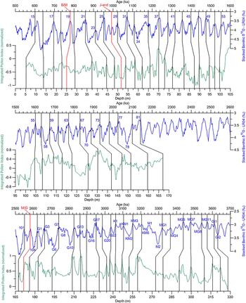
Initial age model for core XK12. Results of the visual correlation of the integrated pollen index (green) from core XK12 with the LR04 benthic δ18O stack (blue) (Lisiecki and Raymo, Reference Lisiecki and Raymo2005). The three red lines are independent geomagnetic age control points. (For interpretation of the references to color in this figure legend, the reader is referred to the web version of this article.)

Astronomically tuned time scale
The evolution of the EAWM on the glacial–interglacial time scale was mainly driven by ice sheet variations (Liu and Ding, Reference Liu and Ding1993; Ding et al., Reference Ding, Derbyshire, Yang, Yu, Xiong and Liu2002; Sun et al., Reference Sun, Clemens, An and Yu2006a), which are reflected by the LR04 stacked benthic δ18O record (Lisiecki and Raymo, Reference Lisiecki and Raymo2005). The integrated pollen index from core XK12, which is regarded as an EAWM indicator and therefore influenced by variations in global ice volume, would be expected to show a pattern of fluctuations similar to that of the marine δ18O record. The resolution of the chronostratigraphic framework established by stratigraphic correlation and magnetostratigraphy is too low to investigate the evolution of the EAWM on the glacial–interglacial time scale. Therefore, we developed an astronomically tuned time scale based on the high-resolution integrated pollen index. Matching paleoclimatic records to time series of orbital parameters (i.e., orbital tuning) has proven useful for developing age models and has been widely applied to marine sediments (Raymo et al., Reference Raymo, Ruddiman, Backman, Clement and Martinson1989; Ruddiman et al., Reference Ruddiman, Raymo, Martinson, Clement and Backman1989; Shackleton et al., Reference Shackleton, Berger and Peltier1990; Hilgen, Reference Hilgen1991a, Reference Hilgen1991b; Tian et al., Reference Tian, Wang, Cheng and Li2002; Palike et al., Reference Palike, Frazier and Zachos2006; Ao et al., Reference Ao, Dekkers, Qin and Xiao2011; Yi et al., Reference Yi, Jian, Liu, Zhu, Zhang, Wang and Deng2018), Chinese loess-paleosol and red clay sequences (Ding et al., Reference Ding, Yu, Rutter and Liu1994, Reference Ding, Derbyshire, Yang, Yu, Xiong and Liu2002; Lu et al., Reference Lu, Liu, Zhang, An and Dodson1999; Heslop et al., Reference Heslop, Langereis and Dekkers2000; Sun et al., Reference Sun, Clemens, An and Yu2006a), and continental lacustrine and fluvial strata (Prokopenko et al., Reference Prokopenko, Hinnov, Williams and Kuzmin2006; Hu et al., Reference Hu, Goddu, Appel and Verosub2007; Ao et al., Reference Ao, Dekkers, Xiao, Yang, Qin, Liu, Qiang, Chang and Zhao2012; Nowaczyk et al., Reference Nowaczyk, Haltia, Ulbricht, Wennrich, Sauerbrey, Rosén, Vogel, Francke, Meyer-Jacob and Andreev2013; Torres et al., Reference Torres, Hooghiemstra, Lourens and Tzedakis2013).
The following steps were followed to produce a tuned age model for core XK12. First, three magnetostratigraphic age control points (the B/M boundary at 25.0 m, the end of the Jaramillo event at 51.4 m, and the M/G boundary at 170.9 m) were selected to establish an initial age model (Ogg, Reference Ogg, Gradstein, Ogg, Schmitz and Ogg2012) (Figs. 2 and 4). This model was fixed during the subsequent tuning processes. As expected, the fluctuations and phase of the integrated pollen index were very similar to the variations of the LR04 δ18O stack (Lisiecki and Raymo, Reference Lisiecki and Raymo2005) (Fig. 4). Then, assuming a direct relationship between global ice volume fluctuations and EAWM intensity, we visually correlated the integrated pollen index from core XK12 to the LR04 curve. Peaks in the integrated pollen index were correlated with troughs in the LR04 stack, representing interglacial stages; and troughs in the integrated pollen index were correlated to peaks in the LR04 stack, representing glacial stages (Fig. 4). Fifty-eight age control points were thereby obtained, and they are listed in Supplementary Table S2 and Fig. 4. The resulting average sediment accumulation rate of the section between the B/M boundary and the end of the Jaramillo event is 12.75 cm/ka. Notably, the sediment accumulation in Sanjiang Plain in the early and middle Pleistocene was estimated to be 10 cm/ka (Qi et al., Reference Qi, Zhang, Lu, Bai and Yang2015).
Next, a suitable target curve was selected to establish an astronomical time scale. The La2004 astronomical solution computed with present-day input values for the dynamical ellipticity of the Earth and tidal dissipation in the evolution of the Earth–Moon system (Laskar et al., Reference Laskar, Robutel, Joutel, Gastineau, Correia and Levrard2004) has been shown to be appropriate for geologic records (Palike et al., Reference Palike, Frazier and Zachos2006; Husing et al., Reference Husing, Hilgen, Aziz and Krijgsman2007). The obliquity parameter has been suggested to have a stronger and more consistent influence on climate change since the Pliocene than either precession or eccentricity (Ruddiman et al., Reference Ruddiman, Raymo and McIntyre1986; Muller and MacDonald, Reference Muller and MacDonald1997; Huybers, Reference Huybers2006; Tian et al., Reference Tian, Zhao, Wang, Li and Cheng2008; Naish et al., Reference Naish, Powell, Levy, Wilson, Scherer, Talarico and Krissek2009). Both the LR04 stack and Chinese loess records exhibit distinct fluctuations at a frequency corresponding to that of obliquity in the late Pliocene and early Pleistocene (Ding et al., Reference Ding, Yu, Rutter and Liu1994; Lisiecki and Raymo, Reference Lisiecki and Raymo2005). Thus, the orbital obliquity curve of La2004 was selected as the target curve for astronomical tuning. The time scale of the LR04 stack is based on the assumption that the ice sheets were directly modulated by orbital variations (Imbrie and Imbrie, Reference Imbrie and Imbrie1980; Lisiecki and Raymo, Reference Lisiecki and Raymo2005), and therefore when conducting the visual correlation, the initial age model would have incorporated the lag inherent in the LR04 stack. Therefore, during the tuning process, we assumed zero lag between calculated obliquity and the obliquity signal in the integrated pollen index record of core XK12.
Because of the sedimentary hiatus in core XK12 in the early Pleistocene, the tuned time scale of core XK12 was developed separately in two parts. The dynamic optimization method (Yu and Ding, Reference Yu and Ding1998) was used to filter the obliquity (41 ka) signal from the integrated pollen index based on the initial age model, and then the filtered curve was compared with the orbital obliquity curve. This process was repeated multiple times, slightly altering the age control points of the initial age model to achieve a satisfactory correlation. The most plausible result is illustrated in Fig. 5. At the end of this iterative tuning procedure, we selected 35 and 23 age control points to establish an astronomically tuned time scale for the Pleistocene and Pliocene sections, respectively. The initial and final age control points are listed in Supplementary Table S2, and the integrated pollen index with astronomically tuned ages is listed in Supplementary Table S3.
Astronomically tuned time scale for core XK12: (a) sedimentation rate of core XK12; (b) integrated pollen index of core XK12; (c) LR04 benthic δ18O stack (Lisiecki and Raymo, Reference Lisiecki and Raymo2005); and (d) comparison of filtered obliquity curve from the integrated pollen index (red) and calculated orbital obliquity (black) (Laskar et al., Reference Laskar, Robutel, Joutel, Gastineau, Correia and Levrard2004). (For interpretation of the references to color in this figure legend, the reader is referred to the web version of this article.)

During the tuning, a constant sedimentation rate was assumed between two adjacent age control points. The age control points remained at a fixed depth from the initial age model, and the age difference before and after the tuning of each point was no more than 10 ka (see Supplementary Table S2). This tuning procedure resulted in better correlations between filtered obliquity and orbital obliquity and between the integrated pollen index and the LR04 stack. Another important constraint on tuning was that the sediment accumulation rate should not change abruptly (Sun et al., Reference Sun, Clemens, An and Yu2006a). According to the tuned time scale of core XK12, the sediment accumulation rate was relatively uniform, ranging from 5 to 25 cm/ka. After tuning, the ages of the top and the bottom of the Pliocene section of core XK12 are 2.54 and 3.63 Ma, respectively, and the ages of the top and the bottom of the Pleistocene section are 0.60 and 2.15 Ma, respectively (Fig. 5).
DISCUSSION
Influence of neotectonic activity on the regional sedimentary environment
In northeast Asia, tectonic activity and the associated fault zones have determined the distribution of sedimentary basins and the surrounding mountains (Ding, Reference Ding1988). Although major basins such as the Sanjiang and Xingkaihu Plains subsided and were subject to almost continuous sediment accumulation during the late Cenozoic, sedimentary hiatuses caused by intermittent neotectonic activity, accompanied by volcanic eruptions and changes in river systems, have occurred (Korotkii et al., Reference Korotkii, Grebennikova, Karaulova and Belyanina2007; Qiu et al., Reference Qiu, Wang, Makhinov, Yan, Lian, Zhu, Zhang and Zhang2014). There are many paraconformities and unconformities in the Neogene and Quaternary stratotypes in northeast Asia (Fig. 2). The widespread stratigraphic evidence shows that sedimentary hiatuses exist and are possibly related to neotectonic activity. Stratigraphic correlation has revealed two paraconformities in core XK12: one in between the topmost eolian Hugang Fm. and the middle Pleistocene lacustrine clays, and the other in between the early Pleistocene diluvial sands and Neogene lacustrine clays (Figs. 2 and 4). This indicates that the graben depression of Xingkaihu Plain was affected at least twice by intermittent regional tectonic activity since the late Pliocene. The high-resolution astronomically tuned time scale for core XK12 provides further information about the causes and processes of these interruptions in sedimentation.
The late Pliocene interval of core XK12 and the Fujin Fm. consists mainly of alluvial sands interbedded with diluvial material. These very thick deposits with comparable lithology and color indicate that the Sanjiang and Xingkaihu Plains experienced a long stage of fluvial development during 3.63–2.76 Ma. Alluvial sedimentation likely accompanied continuous differential tectonic activity, mountain uplift was the source of coarse clastic material, and basin subsidence provided accommodation space for sedimentation. The late Pliocene Jidong Basalt and the lower basaltic part of the Shufanskaya Fm. confirm the occurrence of synchronous tectonic activity in the adjacent Changbai Mountains (BGMRHP, 1993; Pavlutkin and Petrenko, Reference Pavlyutkin and Petrenko2010) (Fig. 2). After 2.76 Ma, lacustrine sediments began to be deposited in Xingkaihu Plain, which was synchronous with the development of the Fujin Fm., and even with the silt and clay sediments of the middle part of the Shufanskaya Fm. This indicates that the Ussuri River catchment commenced a phase of steady subsidence. The development of the river system was accompanied by the formation of large lakes in the middle and lower reaches of the Ussuri River.
At the beginning of the Pleistocene, at 2.54 Ma, lacustrine sedimentation at the site of core XK12 and in Sanjiang Plain ceased abruptly, and at the same time a volcanic eruption resulted in the deposition of basalt overlying the lacustrine sediments of the Shufanskaya Fm. in the middle reach of the Suifen River. This widespread paraconformity serves as the isochronal Neogene/Quaternary boundary in northeast Asia (BGMRHP, 1993; Pavlutkin and Petrenko, Reference Pavlyutkin and Petrenko2010) (Fig. 2) and was most likely the result of major regional tectonic activity. The uplift of the entire basin induced rapid fluvial incision, when watercourses cut into the loose sedimentary deposits. These major geomorphological changes reduced the ability of local sedimentary archives to record environmental changes. A volcanic episode occurred in northeast China at around the Pliocene–Pleistocene transition and is represented by the eruption of the Junjianshan Basalt (2.4–2.6 Ma), the lower Jingpohu Basalt (2.4–2.6 Ma), and the Baijin Basalt (2.41 Ma) in Changbai Mountains. Farther north, the uplift of Xiaoxing'an Mountains accompanied the eruption of the Daxiongshan Basalt, which began at 2.5 Ma (Liu, Reference Liu1987, Reference Liu1988; BGMRHP, 1993). This tectonic activity and associated volcanism resulted in major modification of the Heilongjiang River system and the disappearance of paleolakes such as Dalianhe-Xiangshun paleolake in the western part of Sanjiang Plain (Qiu et al., Reference Qiu, Wang, Makhinov, Yan, Lian, Zhu, Zhang and Zhang2014). As a direct result of tectonic uplift, the denudation rate in the Heilongjiang River catchment increased substantially during the late Pliocene–Pleistocene (Nicholson et al., Reference Nicholson, van der Es, Clift, Flecker and Macdonald2016). This series of major hydrologic and geomorphic changes substantially altered the sedimentary environment throughout the entire Heilongjiang River catchment and resulted in the widespread paraconformity between the Neogene and Quaternary series.
Subsequently, tectonic uplift weakened and was eventually replaced by subsidence. Sediments began to be deposited in watercourses and then on floodplains and terraces, finally infilling the valleys created by the previous uplift. This process developed retrogressively, from the lower reaches and then to the middle and upper reaches, in sequence. Sediment deposition at the site of core XK12 recommenced at 2.15 Ma. First, poorly sorted diluvial sediments were deposited, probably soon after the accumulation of the Suibin Fm. in Sanjiang Plain. The diluvial sediments in core XK12 are variously colored and differ substantially from those of the Suibin Fm., but they are similar to those of the Annenskaya Fm. in the southern part of the Xingkai Basin. The provenance of the diluvial sediments is the variously colored weathering crust developed along the slopes around the southern and western parts of the Xingkai Basin. During this period, the different reaches of the Ussuri River were characterized by diverse sedimentary environments. Alternating alluvial and lacustrine sedimentation in Sanjiang Plain indicates the development of a fluvial–lacustrine system. The diluvial sediments in core XK12 indicate geomorphic differences in Xingkaihu Plain, and the altitudinal difference between the Xingkaihu and Sanjiang Plains was also substantial. The thin, proximal lacustrine Annenskaya Fm. with a paraconformity at its surface indicates that a small, transient lake likely developed in the upper Ussuri River valley. Eventually, a sequence of light-colored alluvial sands was deposited at the site of core XK12, which clearly correspond to the lower Pleistocene alluvial sediments in Xingkaihu Plain and the middle Pleistocene Suifunskaya Fm. in the middle reach of the Suifen River (Fig. 2). This diachronous sedimentary horizon was likely caused by the combination of a uniform provenance and a developing fluvial system.
At 1.2 Ma, a paraconformity developed in places between the Suibin and Nongjiang Fms. (Fig. 2), which may have been caused by transient tectonic uplift in northeast Asia. The Longgang volcanic episode in northeast China occurred during 0.8–1.5 Ma, represented by basaltic eruptions in the Mudanjiang River valley (0.89–1.39 Ma) and in Longgang Mountain (0.86–1.23 Ma) of the Changbai Mountains (Liu, Reference Liu1987, Reference Liu1988). Subsequently, the altitudinal difference between the Xingkaihu and Sanjiang Plains decreased; lacustrine sedimentation began to occur in Xingkaihu Plain, and light-colored alluvial sediments began to be continuously deposited in the middle reach of the Suifen River. This sedimentary environmental evolution of the Heilongjiang River catchment is also recorded by the appearance of paleo-Lake Songliao in the upper reach (Zhan et al., Reference Zhan, Zeng, Xie, Yang, Ge, Ma, Chi, Kang, Jiang, Yu, Zhang, Li and Zhou2019). Following the B/M geomagnetic polarity transition, all three depressions of the Ussuri River began to accumulate dark-gray lacustrine sediments that represent the main stage of regional lake development in the Quaternary. According to the record of core XK12 and other stratotypes in the Ussuri River catchment, diluvial, alluvial, and lacustrine sedimentation occurred in sequence, indicating steady subsidence of Xingkaihu Plain during 2.15–0.60 Ma.
At 0.60 Ma, lacustrine sedimentation in the three depressions ceased abruptly and almost synchronously. This likely resulted from intense regional tectonic activity related to the Baitoushan volcanic episode in the Changbai Mountains, which started at ~0.58 Ma (Liu, Reference Liu1987, Reference Liu1988). In the southern Xingkai Basin, part of the alluvial–lacustrine planation surface began to be uplifted and became the dividing range between the modern Xingkai Basin and the Suifen River catchment (Belyanina et al., Reference Belyanina, Belyanin and Mityureva2009; Bondarenko et al., Reference Bondarenko, Blokhina and Utescher2013). Farther west, the Songliao dividing ranges were uplifted in the middle of Songliao Plain (Qiu et al., Reference Qiu, Wang, Makhinov, Yan, Lian, Zhu, Zhang and Zhang2014). This type of general regional uplift, together with large-scale falls in sea level as a result of the increased amplitude of glacial–interglacial climate fluctuation, promoted headward erosion in the river valleys of northeast Asia. These geomorphic, hydrologic, and climatic factors together resulted in the successive disappearance of a series of paleolakes that had previously developed in northeast Asia, including paleo-Lake Songliao (Qiu et al., Reference Qiu, Wang, Makhinov, Yan, Lian, Zhu, Zhang and Zhang2014; Zhan et al., Reference Zhan, Zeng, Xie, Yang, Ge, Ma, Chi, Kang, Jiang, Yu, Zhang, Li and Zhou2019).
After the abrupt end of sedimentation in 0.60 Ma, the failure of the Xingkaihu and Sanjiang Plains to accumulate sediments reflects the occurrence of only weak and partial subsidence. In the late Pleistocene, the previously deposited sediments underwent fluvial incision, and two series of terraces and wide floodplains formed within the valleys of large rivers (BGMRHP, 1993). Four conspicuous sand ridges, representing four distinct periods of lake lowstand, formed in the northern margin of Lake Xingkai (Qiu et al., Reference Qiu, Wan and Wang1988; Long et al., Reference Long, Shen, Wang, Gao and Frechen2015). However, the flat surface of the plains remained almost intact, including the lacustrine dividing range between the Xingkai Basin and the Suifen River. These low erosion rates were likely due to the low relative elevation difference between the dividing range and the valleys on the two sides and the low absolute altitudes of the entire Heilongjiang and Ussuri River catchments. Thus, the whole of northeast Asia entered a phase of tectonic quiescence following the previous rapid uplift phase.
Evaluation of the astronomical time scale
We now address the robustness of the astronomical time scale of core XK12 from three perspectives. First, all of the major tributaries of the Xingkai Basin are sourced from mountains in the east and southwest, which are occupied by coniferous and mixed broadleaf–coniferous forest at higher elevations. The rivers then flow through areas dominated by broadleaf forest in the piedmont zones, and then through meadow and peatland in the lowlands, before finally discharging into the plain (Fig. 1b). Therefore, the pollen record preserved in the lacustrine sediments of Xingkaihu Plain likely reflects the integrated vegetational history of the entire basin. In addition, Xingkaihu Plain is very flat, resulting in frequent river channel migration. Continuous lateral erosion by the large tributaries would have resulted in the mixing of new alluvial sediments with previously deposited sediments on the surface of the plain. Therefore, most of the alluvial sediment sequences in the plain would have preserved a pollen record that reflected integrated vegetational conditions across the entire basin rather than solely within the plain. In addition, it is difficult for old pollen to be incorporated into newly deposited sediments due to the progressive subsidence of the sedimentary basin. Consequently, the lacustrine and alluvial sediments preserved in Xingkaihu Plain can provide a reliable record of the history of the entire Xingkai Basin on millennial through orbital time scales.
Second, reference to the ages of geomagnetic polarity reversal boundaries is an effective means of evaluating the astronomical time scale. The ages of the three geomagnetic polarity reversals selected to establish an initial age model were fixed during the entire tuning process. The astronomically tuned age of the early Pleistocene interval of clay sediments in core XK12 from 129.81 to 136.85 m is 1.815 to 1.900 Ma; this interval is of normal polarity and corresponds to the Olduvai subchron. The astronomically tuned age of the Pliocene interval of clay sediments from 207.90 to 210.28 m is 2.827 to 2.840 Ma; this interval is of normal polarity and falls within the Gauss chron. The other Pliocene interval of clay sediments, from 257.11 to 264.25 m, has an astronomically tuned age of 3.195 to 3.255 Ma; there are two reversed geomagnetic events within this interval, each with a duration of more than 60 ka. If this section is considered to record the Mammoth event, then an error of at least 25 ka error exists in the astronomically tuned time scale; and if it is considered to be part of the Kaena event, then the error is at least 145 ka (Ogg, Reference Ogg, Gradstein, Ogg, Schmitz and Ogg2012) (Fig. 2).
In addition, a layer of well-sorted and well-rounded pebbles and cobbles is present at 265.30–270.57 m in core XK12, which reflects fluvial incision by the river and continuous subsidence of the plain. Notably, the lithology and color of the sediments above and below the pebble layer are uniform. This distinctive sedimentary sequence is quite different to that which would result from regional tectonic uplift (Fig. 2), and therefore the formation of this riverbed horizon can be attributed to a rapid fall in the base level of the lower reaches of the Heilongjiang River. Considering that both the altitude and elevation range of the Heilongjiang River system are quite small, we assume that sea-level change was the cause of the rapid fall in base level. Notably, the tuned age of the riverbed horizon is 3.263–3.308 Ma, corresponding to Marine Isotope Stage (MIS) M2 (Lisiecki and Raymo, Reference Lisiecki and Raymo2005) (Figs. 5 and 6). MIS M2 is characterized by the largest increase in benthic δ18O value in the late Pliocene, indicating a major fall of global sea level (Dwyer and Chandler, Reference Dwyer and Chandler2009; Miller et al., Reference Miller, Wright, Browning, Kulpecz, Kominz, Naish, Cramer, Rosenthal, Peltier and Sosdian2012). This fall of global sea level may have triggered worldwide headward erosion, including of the Heilongjiang River system. As a result, the Xingkai Basin would have been scoured due to the resulting headward erosion of the Ussuri River, and the site of core XK12, which was previously a depocenter, would have been subjected to fluvial incision. This fluvial incision event occurred against a background of continuous basin subsidence, which would have promoted the deposition of the thick layer of fluvial pebbles and cobbles at the site of core XK12. After MIS M2, alluvial sedimentation recommenced in Xingkaihu Plain. As mentioned earlier, river channel migration occurs frequently in a flat, subsiding plain. After a brief period of alluvial sedimentation, the main stream moved away from the site of core XK12, and an oxbow lake formed. The interval of clay-rich sediments from 257.11 to 264.25 m in core XK12 likely represents deposition within such a lake. Thus, this interval, which is of reversed polarity, can be confirmed as being deposited within the Mammoth event rather than during the later Kaena event (Fig. 2).
(color online) Comparison of the evolution of the East Asian winter monsoon based on the integrated pollen index of core XK12with the LR04 benthic δ18O stack (Lisiecki and Raymo, Reference Lisiecki and Raymo2005) and stacked mean grain size of quartz particles record from the Lingtai and Zhaojiachuan sections in the Chinese Loess Plateau (Sun et al., Reference Sun, Clemens, An and Yu2006a).

From the foregoing, we conclude that the geomagnetic evidence confirms the reliability of the astronomical age model of core XK12. Although relatively short sedimentary hiatuses may still occur within the intervals of alluvial and diluvial sediments, the age model for core XK12 can be used to explore regional climatic and environmental changes on the orbital time scale.
Evolution of the EAWM since 3.6 Ma
Based on the integrated pollen index of core XK12 and the astronomical time scale, we now attempt to reconstruct the history of the EAWM since the late Pliocene. To aid interpretation, we compared the record from the Xingkai Basin with paleoclimatic records from the Chinese Loess Plateau and elsewhere. The stacked record of MGSQ, an EAWM proxy, from the Lingtai and Zhaojiachuan sections in the north-central Chinese Loess Plateau (Sun et al., Reference Sun, Clemens, An and Yu2006a), was selected for comparison. Except for the Pleistocene hiatuses in core XK12, the integrated pollen index and the MGSQ stack co-vary synchronously, reflecting the stepwise enhancement of the EAWM since 3.6 Ma (Figs. 1a and 6). Comparison of the integrated pollen index, the MGSQ stack, and the LR04 benthic δ18O stack (Lisiecki and Raymo, Reference Lisiecki and Raymo2005) reveals that both the integrated pollen index and the MGSQ stack co-vary with long-term global cooling since 3.6 Ma, with the amplitude of glacial–interglacial fluctuations exhibiting a stepwise increase (Fig. 6).
In the late Pliocene, both records of the EAWM indicate a period of weak winter monsoon beginning at ~3.4 Ma, in the middle Pliocene warm period. The evolution of the EAWM has been used as an indicator of variations in the NHG because of the direct relationship between the two. MIS M2 is identified as representing a major global sea-level fall caused by the initiation of the NHG (De Schepper et al., Reference De Schepper, Gibbard, Salzmann and Ehlers2014; Dolan et al., Reference Dolan, Haywood, Hunter, Tindall, Dowsett, Hill and Pickering2015; Tan et al., Reference Tan, Ramstein, Dumas, Contoux, Ladant, Sepulchre, Zhang and De Schepper2017). Although a layer of riverbed gravel is present in core XK12 in the interval of MIS M2, due to a global sea-level lowstand, the integrated pollen index does not suggest that the EAWM was strong at this time. The MGSQ stack from the Chinese Loess Plateau also fails to indicate a stronger EAWM during MIS M2 (Fig. 6). However, the records from the Xingkai Basin and the Chinese Loess Plateau both reflect an intensified EAWM in the later part of MIS KM2 (Fig. 6). The initiation of the NHG in MIS M2 evidently did not have a substantial effect on the EAWM, possibly indicating that its effects were not globally expressed. Subsequently, in MIS KM2, the intensification of the EAWM may reflect intensified cooling in Siberia, the source area of the EAWM.
The integrated pollen index began to decrease at ~2.8 Ma, during the Pliocene–Pleistocene transition, reflecting the strengthening of the EAWM in the Xingkai Basin (Fig. 6). In addition, there was a continuous coarsening of the MGSQ stack at ~2.72 Ma (Sun et al., Reference Sun, Clemens, An and Yu2006a). Before this, on the Chinese Loess Plateau, a typical loess unit, L34, was identified within the uppermost red clay, marking the onset of extensive loess deposition at ~2.8 Ma (Yang and Ding, Reference Yang and Ding2010). Marine isotope records show a major phase of Northern Hemisphere ice sheet growth during 3.3–2.8 Ma (Lisiecki and Raymo, Reference Lisiecki and Raymo2005), and a dramatic increase in the supply of ice-rafted debris to the northwest Pacific and the Norwegian Sea at ~2.8 Ma (Maslin et al., Reference Maslin, Haug, Sarnthein, Tiedemann, Erlenkeuser and Stax1995). This strengthening of the EAWM over northern China since the late Pliocene indicates a rapid reorganization of the regional climate system in East Asia, which may have been causally related to the initiation of major NHG (Han et al., Reference Han, Fyfe, Longstaffe, Palmer, Yan and Mai1997; Ding et al., Reference Ding, Rutter, Sun, Yang and Liu2000; Xiong et al., Reference Xiong, Ding, Jiang, Yang and Liu2003). In MIS G10 (2.8 Ma), benthic δ18O values increased to the level of MIS M2 and then increased continuously, indicating a steady increase in NHG (Lisiecki and Raymo, Reference Lisiecki and Raymo2005). The trend of EAWM enhancement continued to the deposition of loess layer L32 (2.45 Ma) in the Chinese Loess Plateau (Sun et al., Reference Sun, Clemens, An and Yu2006a), and the trend is also evident in the integrated pollen record until the occurrence of a paraconformity in core XK12 at 2.54 Ma (Fig. 6).
In the early Pleistocene, both the integrated pollen index and the MGSQ stack reflect an enhanced EAWM, with fluctuations of larger amplitude than those in the Pliocene. In addition, step-like increases in the EAWM are evident at 1.60 Ma and 1.65 Ma in the Xingkai Basin and the Chinese Loess Plateau, respectively. The climatic event at ~1.6 Ma is recognized in marine records worldwide and has been attributed to the reorganization of oceanic circulation (Lisiecki, Reference Lisiecki2014; Wang et al., Reference Wang, Li and Tian2014a; Karnauskas et al., Reference Karnauskas, Mittelstaedt and Murtugudde2017). By about MIS 55 (1.6 Ma), the LR04 stack suggests that the maximum global ice volume of interglacial stages reached a limit; however, the volume continued to increase during glacial stages. Consequently, the rate of increase of global ice volume slowed, although the amplitude of glacial–interglacial cycles began to increase at the same time (Lisiecki and Raymo, Reference Lisiecki and Raymo2005) (Fig. 6). The difference in timing of the step-like enhancement of the EAWM recorded in the Xingkai Basin and the Chinese Loess Plateau likely reflects regional differences within the EAWM domain of the response to oceanic forcing. It appears that the EAWM intensified first in the middle-latitude Chinese Loess Plateau, and then subsequently at 1.60 Ma in the high-latitude Xingkai Basin.
In the MGSQ stack, the extremely coarse-grained intervals of L33 (~2.6 Ma) and L15 (~1.25 Ma) are commonly interpreted as representing an unusually strong EAWM (Guo et al., Reference Guo, Liu, Fedoroff, Wei, Ding, Wu, Lu, Jiang and An1998; Ding et al., Reference Ding, Rutter, Sun, Yang and Liu2000; Qiang et al., Reference Qiang, Li, Powell and Zheng2001; Sun et al., Reference Sun, Clemens, An and Yu2006a, Reference Sun, An, Clemens, Bloemendal and Vandenberghe2010; Zhang et al., Reference Zhang, Li, Guo, Ma, Li, Ye and Yu2016). However, no corresponding interval of substantially increased ice volume is evident in the LR04 stack at ~2.6 and ~1.25 Ma, and the integrated pollen index indicates a weak EAWM at these times (Fig. 6). This discrepancy may be the result of genuine regional climatic differences or specific characteristics of the two environmental proxies. It has been proposed that the grain size variations of windblown loess in the Chinese Loess Plateau are controlled by both the distance of the site of deposition to the desert margin (Ding et al., Reference Ding, Sun, Rutter, Rokosh and Liu1999) and the strength of the EAWM (An et al., Reference An, Kukla, Porter and Xiao1991; Liu and Ding, Reference Liu and Ding1998). A study of three transects across the Chinese Loess Plateau during the last glacial stage showed that extremely coarse loess was only present in the northern part of the plateau and was closely linked to the migration of the southern border of the deserts in northern China, driven by the aridification of the Asian interior. The grain size record of the Jingbian section in the Chinese Loess Plateau indicates four coarsening events at 2.6, 1.2, 0.7, and 0.2 Ma, which were interpreted as reflecting the southward migration of the Mu Us Desert since 3.5 Ma (Ding et al., Reference Ding, Derbyshire, Yang, Sun and Liu2005). In addition, loess began to be deposited at Chifeng, in northeast China, at ~1.22 Ma, which was related to increased inland aridity (Zeng et al., Reference Zeng, Lu, Yi, Li, Lv, Zhang, Xu, Wu, Feng and Cui2016, Reference Zeng, Lu, Yi, Stevens, Xu, Zhuo, Yu and Zhang2017) (Fig. 1a); furthermore, provenance changes of loess at 2.6 and 1.2 Ma were also related to inland aridification (Ma et al., Reference Ma, Sun, Tada, Yan, Chen, Lin and Nagashima2015; Yan et al., Reference Yan, Ma and Sun2017). Therefore, we suggest that these two extremely coarse intervals that are evident on the Chinese Loess Plateau might reflect intensified aridity in the Asian interior, and not necessarily the strengthening of the EAWM.
CONCLUSIONS
A 328.58-m-long core of alluvial–lacustrine sediments (XK12) was drilled in Xingkai Basin, northeast Asia, to reconstruct the long-term evolution of the EAWM. The pollen record of thermophilous trees and terrestrial herbs, which is sensitive to winter temperature conditions, was used to produce an index of EAWM variations on the glacial–interglacial time scale. An initial age model was developed based on lithostratigraphy and magnetostratigraphy and was then refined using orbital tuning. The integrated pollen index provides a continuous record of EAWM evolution in northeast Asia since 3.6 Ma, except for two sedimentary hiatuses in the early Pleistocene (2.54–2.15 Ma) and the middle Pleistocene (since 0.60 Ma), which were caused by regional tectonic activities. The integrated pollen index reveals a stepwise pattern of EAWM evolution in the Xingkai Basin, consistent with MGSQ records from the Chinese Loess Plateau. Two major increases in EAWM intensity occurred at ~2.8 and ~1.6 Ma, which are interpreted to reflect the initiation and enhancement of NHG and global cooling.
ACKNOWLEDGMENTS
We thank Professors Youbin Sun and Xiaoke Qiang and Dr. Hao Long for valuable suggestions for the development of the chronology methods. We also thank Dr. Mingming Ma and colleagues for supervising the drilling work, which was conducted by Qinghai Jingcheng Geological & Mining Co., Ltd. We thank Jan Bloemendal for scientific suggestions and for improving the English. Two anonymous reviewers and the editors (Nicholas Lancaster and Wyatt Oswald) are acknowledged for their constructive comments and suggestions, which have greatly improved the article. This work was supported by the National Natural Science Foundation of China (No. 41430530).
SUPPLEMENTARY MATERIAL
To view supplementary material for this article, please visit https://doi.org/10.1017/qua.2019.45.