Introduction
Traditionally, plant communities in Antarctica have been classified using the physiognomic-dominance criteria initially developed in the maritime Antarctic region (Longton Reference Longton1967, Gimingham & Smith Reference Gimingham, Smith and Holdgate1970) and subsequently extended and adapted to continental Antarctica by Seppelt & Ashton (Reference Seppelt and Ashton1978), Longton (Reference Longton1979), Smith (Reference Smith1988, Reference Smith1990), and Melick & Seppelt (Reference Melick and Seppelt1997). Two main vegetation formations were recognized: the Antarctic herb tundra formation (maritime Antarctic only) and the Antarctic non-vascular cryptogam tundra formation, each with a number of subformations (based on growth form and community dominants), associations and sociations (based on floristic composition) (see Gimingham & Smith Reference Gimingham, Smith and Holdgate1970).
Unlike the maritime Antarctic, where two native vascular plants exist, the vegetation of continental Antarctica is composed entirely of cryptogams (microfungi, cyanobacteria, algae, lichens, bryophytes). In the Antarctic non-vascular cryptogam tundra formation three principal subformations were described (Smith Reference Smith1988, Reference Smith1990): short moss turf and cushion subformation (dominated by mosses), foliose and fruticose lichen subformation (dominated by macrolichens), crustaceous lichen subformation (dominated by crustose and microlichens).
There are some short-comings in this classification scheme. Communities with similar physiognomy but differing ecology may be grouped together within a single subformation. Communities lacking any prevailing physiognomic dominance are difficult to place within the defined subformations and thus would require intermediate categories. A physiognomic classification of the vegetation does not permit ready comparison of different localities as it does not unequivocally relate each vegetation type to its floristic composition.
Plant communities may be classified according to a variety of different criteria (Mueller-Dombois & Ellenberg Reference Mueller-Dombois and Ellenberg1974), including physiognomic and structural criteria. In this context it is possible to emphasize the dominant species in the prevailing synusia, or to focus on significant groups of species (Braun-Blanquet Reference Braun-Blanquet1964). For continental Antarctic vegetation, there have been only a few studies applying phytosociological criteria for vegetation classification (Nakanishi Reference Nakanishi1977, Seppelt & Ashton Reference Seppelt and Ashton1978, Longton Reference Longton1979, Kappen Reference Kappen1985, Smith Reference Smith1988, Castello & Nimis Reference Castello and Nimis1995), in most instances following the subjective scheme developed for the maritime Antarctic (Gimingham & Smith Reference Gimingham, Smith and Holdgate1970, Smith Reference Smith1996). A reliable phytosociological classification of the Antarctic vegetation has been difficult to develop and implement due to the inordinate taxonomic difficulties. Any attempt to develop a classification scheme applicable to the whole continental region has been compounded by the lack of biogeographical and phytosociological information for large areas of Antarctica. Despite a recent lichen flora (Øvstedal & Smith Reference Øvstedal and Smith2001) and the preparation of a moss flora (Ochyra et al. in press), many taxonomic difficulties, particularly with lichens, continue to exacerbate the work of the phytosociologist.
Despite these difficulties, we here describe a preliminary new floristic approach to the classification of southern and northern Victoria Land vegetation, based on floristic composition. This paper also provides data on the floristic composition and distribution patterns of the plant communities across a large area of continental Antarctica.
Materials and methods
Study area
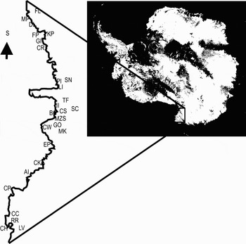
Twenty six sites were selected in Victoria Land, continental Antarctica, along a latitudinal gradient from Cape Hallett (72º26′S, 169º56′E) to Lake Fryxell in the Taylor Valley, McMurdo Dry Valleys region (77º35′S, 163º04′E) (Fig. 1). The climate of this region is cold and arid (Øvstedal & Smith Reference Øvstedal and Smith2001). In the Terra Nova Bay area of northern Victoria Land annual precipitation is mostly as snow, (with c. 270 mm y-1 water equivalent), and the mean annual air temperature is c. -15ºC (unpublished data ENEA). The mean summer air temperature (December–February) ranges between -0.1 and -2.0°C (Cannone & Guglielmin, unpublished data). In the vicinity of Mario Zucchelli Station, at Boulderclay (74º43′S, 164º05′E) the mean annual air temperature for the period 1997–2003 ranged between -16.4ºC and -15.1ºC (Guglielmin Reference Guglielmin2006). Farther south in Victoria Land the climate is drier and colder with a mean annual air temperature of -17.4ºC at McMurdo Station (77º51′S, 166º40′E) (Bockheim Reference Bockheim1995). All sites are characterized by the occurrence of continuous permafrost. At Boulderclay, during the period 1997–2003, the active layer thickness ranged between 0–93 cm (Guglielmin Reference Guglielmin2006) whilst earlier data show it to have been 0–60 cm in the McMurdo region (Bockheim Reference Bockheim1995).
Location of the study sites in Victoria Land. Legend: FL = Fryxell Lake, DI = Dunlop Island, MP = Marble Point, FP = Finger Point, KP = Kar Plateau, GI = Gregory Island, CR = Cape Ross, SN = Starr Nunatak, PI = Prior Island, LI = Lamplugh Island, TF = Tarn Flat, II = Inexpressible Island, BC = Boulderclay, MZS = Mario Zucchelli Station, CS = Cape Sastrugi, GO = Gondwana, MK = Mount Keinath, CW = Cape Washington, SC = Simpson Crags, EP = Edmonson Point, CK = Cape King, AI = Apostrophe Island, CP = Cape Phillips, CC = Crater Cirque, LV = Luca Vittuari point (unofficial name), RR = Redcastle Ridge, CH = Cape Hallett.

Almost all substrate types (granite, basalt, gabbro, metamorphic rocks, moraine and old marine deposits) were considered, always in ice free areas, sometimes close to glacier margins. In some locations, vegetation colonizing periglacial features (debris islands, gelifluction lobes) was also sampled. Several sites included ornithogenic soils.
Vegetation sampling
A standard plot size of 50 × 50 cm was used for all the vegetation surveys, this being determined by minimal area requirements of all plant community types observed in Victoria Land (Cannone, unpublished data). Within each plot, vegetational data were obtained by visual estimates of percentage cover for each species using a 5%-interval scale (modified by Heilbron & Walton Reference Heilbronn and Walton1984a, Reference Heilbronn and Walton1984b). To avoid overestimating species with very low coverage (< 5%), we also distinguished scattered species (coverage of c. 1%) and very scattered species (coverage 0.1% and/or symbol +). For each plot elevation, slope, aspect, surface texture and type of substrate were recorded. The habitat type (glacier foreland, slope, crest, beach, ephemeral channel, rock walls, periglacial features, etc) was described for all relevés. Additional descriptors such as the presence of ornithogenic soils and qualitative estimates of snow and moisture conditions were recorded. A total of 189 relevés were assessed for the analysis. Samples of terricolous and epilithic plants were collected for later taxonomic verification. Species nomenclature follows Castello & Nimis (Reference Castello and Nimis2000), Øvstedal & Smith (Reference Øvstedal and Smith2001) and Castello (Reference Castello2003) for lichens, and Ochyra (Reference Ochyra1998) and Seppelt & Green (Reference Seppelt and Green1998) for bryophytes.
Data analysis
The original field data from 24 locations along a gradient of five degrees of latitude in Victoria Land (Cannone Reference Cannone2005, Reference Cannone2006) were analysed using Statistica®. A hierarchical classification (dendrogram) was derived, applying the unweighted pair-groups average joining rule and the l-r Pearson coefficient as linkage distance, based on floristic composition. The hierarchical tree matrix comprised 189 relevés. The separation of the two main vegetation groups used a linking distance > 0.95, while the separation of the sub-groups used a linking distance between > 0.95 and > 0.6. The suitability of the separation between groups was tested analysing the similarity of the identified groups using the Jaccard index computed by EstimateS (Colwell Reference Colwell2005).
Further analysis by multivariate statistics (ordination by Principal Components Analysis - PCA) allowed us to characterize, although indirectly, which environmental gradients might be related to the vegetation communities identified. In particular, the ordination by PCA was carried out using logarithmic transformation of the original data, applying the scaling through inter-species correlation, the centred standardization by species and the normed standardization by samples using the software CANOCO for Windows (ter Braak & Šmilauer Reference ter Braak and Šmilauer1998).
Results
Nine species of moss, 54 lichens, the chlorophycean alga Prasiola and the general category Cyanobacteria were recorded in this study. The lichen species recorded represent around 95% of all taxa known to occur in the region 71–77ºS and 162–170ºE (Castello & Nimis Reference Castello and Nimis2000, Castello Reference Castello2003) and 72% of all the mosses (Seppelt & Green Reference Seppelt and Green1998, Adams et al. Reference Adams, Bardgett, Ayres, Wall, Aislabie, Bamforth, Bargagli, Cary, Cavacini, Connell, Convey, Fell, Frati, Hogg, Newsham, O'Donnell, Russell, Seppelt and Stevens2006).
Hierarchical classification
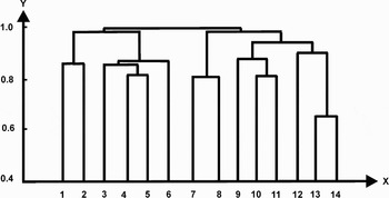
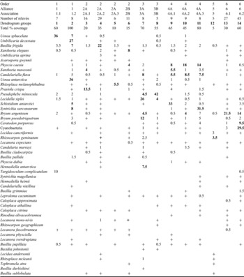
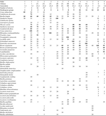
The dendrogram generated by the hierarchical classification (Fig. 2) (Tables I & II) has two main branches (which are separated at a linking distance of 0.96): the left branch (groups 1–6) is characterized by a dominance of lichens and its sub-branches are characterized mainly by: macrolichens (foliose and fruticose lichens; groups 1, 2), and macro- and microlichens (foliose and crustose lichens; groups 3–6). The right branch (groups 7–14) is characterized by a dominance of bryophytes and is divided into three sub-branches characterized by: fruticose lichens and bryophytes (groups 7–8), lichen-encrusted bryophytes (groups 9–11) and by crustose lichens (group 12) and pure bryophytes and Cyanobacteria (groups 13–14). The separation of the main groups within each main branch has been carried out at a linking distance > 0.8 for all groups except for groups 13 and 14 (separated at the linking distance of 0.66).
Dendrogram showing the hierarchical classification of Victoria Land vegetation. The separation of the groups has been carried out at a linking distance > 0.8. The left branch (groups 1–6) identifies the lichen-dominated vegetation, the right branch is composed of transition communities with co-dominance of lichens and bryophytes (groups 7, 8), lichen-encrusted bryophytes (groups 9–11), crustose lichens (group 12) and pure bryophytes (groups 13, 14).

Floristic composition and average coverage (%) of the groups obtained by the hierarchical classification and proposed for the floristic/ecological classification of Victoria Land vegetation. The % cover of the dominant species within each group is given in bold.

Floristic composition and species frequency (%) of the groups obtained by the hierarchical classification and proposed for the floristic/ecological classification of Victoria Land vegetation. Species with frequency > 60% within each group are given in bold. The frequency data have been rounded to the nearest 5%.

The macrolichen vegetation is characterized by the dominance of Usnea sphacelata (group 1) and of Umbilicaria decussata–Usnea antarctica–U. sphacelata (group 2), respectively.
The vegetation dominated by macrolichens and microlichens includes a range of communities characterized by the constant occurrence of Buellia frigida, associated with different species, including Prasiola crispa and Xanthoria mawsonii (group 3), Umbilicaria aprina (in group 4 as associated species to the dominant Buellia frigida), Rhizoplaca melanophthalma (group 5), Xanthoria elegans and Physcia caesia (group 6).
In contrast to the left branch, the right branch of the dendrogram is more heterogeneous, and is characterized by the almost constant occurrence of bryophytes. It includes a range of vegetation types dominated by different growth forms including bryophytes, macrolichens and microlichens.
Groups 7 and 8 represent a transition from the lichen-dominated to the bryophyte-dominated communities and are characterized by the dominance and high frequency of the fruticose lichen Pseudephebe minuscula, associated with the crustose lichen Lecidella siplei, occurring with scattered bryophytes Bryum argenteum and B. pseudotriquetrum.
Groups 9, 10 and 11 are composed of lichen-encrusted bryophytes with a common pool of muscicolous lichens, including Physcia caesia, Candelariella flava, Xanthoria mawsonii, and different prevailing species of bryophytes such as Schistidium antarctici (group 9), Bryum argenteum (group 10), and Syntrichia sarconeurum (formerly Sarconeurum glaciale) (group 11).
Group 12 is anomalously nested within the bryophyte communities and it is completely different from all the other groups of the dendrogram. It is characterized by crustose epilithic lichens with the dominance and high frequency of Lecidea cancriformis and of Rhizocarpon geminatum. The positioning of this group within the dendrogram is confused.
The pure bryophyte communities are represented by groups 13 and 14, the former characterized by the clear dominance of Bryum pseudotriquetrum and the latter by the dominance of Cyanobacteria with Bryum argenteum, Ceratodon purpureus, B. pseudotriquetrum and Schistidium antarctici.
Principal Component Analysis
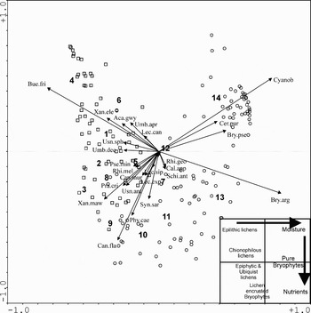
The PCA results (Fig. 3) indicate a continuum rather than a discontinuous distribution of both species and relevés, although it is possible to identify some target (and/or more important and/or dominant) species (characterized by the longer vectors) and a separation of the relevés compatible with the groups already identified by the hierarchical classification (Fig. 2, Tables I & II).
Species-site diagram of the Principal Component Analysis (X = 0.239; Y = 0.96). In the lower right-hand corner there are gradients subjectively derived from the PCA. The numbers represent the fourteen groups of relevés identified by the hierarchical classification (dendrogram of Fig. 2). Legend. Relevés symbols: open circles = relevés of the left branch of the dendrogram (groups 1–6), open squares = relevés of the right branch of the dendrogram (groups 7–14). Species abbreviations: Aca.gwy = Acarospora gwynnii, Bry.arg = Bryum argenteum, Bry.pse = Bryum pseudotriquetrum, Bue.fri = Buellia frigida; Cal.app = Caloplaca approximata, Cal.cit = Caloplaca citrina, Can.fla = Candelariella flava, Can.mur = Candelaria murrayi, Cer.pur = Ceratodon purpureus, Cyanob = Cyanobacteria, Lec.an = Lecidea cancriformis, Lec.sip = Lecidella siplei, Phy.cae = Physcia caesia, Pra.cri = Prasiola crispa, Pse.min = Pseudephebe minuscula, Rhi.geo = Rhizocarpon geographicum, Rhi.mel = Rhizoplaca melanophthalma, Syn.sar = Syntrichia sarconeurum (previously named Sarconeurum glaciale), Shi.ant = Schistidium antarctici, Umb.apr = Umbilicaria aprina, Umb.dec = Umbilicaria decussata, Usn.ant = Usnea antarctica, Usn.sph = Usnea sphacelata, Xan.ele = Xanthoria elegans, Xan.maw = Xanthoria mawsonii.

The distribution of the target species allows recognition of three main groups: a) a group of mainly epilithic lichens dominated by Buellia frigida with Xanthoria elegans, Acarospora gwynnii, Umbilicaria aprina, Usnea sphacelata and Umbilicaria decussata, b) a group of both epiphytic (muscicolous) and ubiquitous lichens and bryophytes characterized by Xanthoria mawsonii, Candelariella flava and Physcia caesia with Prasiola crispa, Usnea antarctica, Syntrichia sarconeurum, Rhizoplaca melanophthalma and Pseudephebe minuscula, c) a group dominated by bryophytes and Cyanobacteria with Bryum argenteum, B. pseudotriquetrum and Ceratodon purpureus as target species for the bryophytes.
The 14 groups of relevés already identified by the hierarchical classification are located in different parts of the diagram: groups 1–6 (lichen dominated vegetation) are located in the left part of the graph (x < 0) and mainly in the upper part (y > 0). The lichen-bryophyte vegetation (groups 7 and 8) and the lichen-encrusted bryophytes (groups 9–11) occur in the lower left part (x < 0; y < 0) of the diagram, while the pure bryophyte communities lie in the right part of the graph (x > 0). The anomalous group 12 is close to the origin, indicating the lack of specific links to the other groups and confirming its anomalous nesting within the dendrogram.
The distribution patterns of the 14 groups and of the target species within the PCA diagram allows us to suggest, although indirectly, the existence of some main environmental determinants, particularly moisture (increasing from left to right) and nutrient gradient (increasing from top to bottom). The patterns outlined by the PCA confirm the separation of communities dominated by epilithic lichens from those dominated by epiphytic and ubiquitous lichens and by bryophytes, respectively. Also, the relevés of the groups 7 and 8 of the dendrogram (Fig. 2, Tables I & II) are located in the PCA (Fig. 3) at a position representing a transition from the lichen-dominated to mixed lichen-bryophytes communities.
Similarity indices
Results obtained from the hierarchical classification were compared to and integrated with those of the PCA to elaborate a synthetic table containing species (rows) and clusters of relevés (columns) as a database from which to compute a similarity matrix.
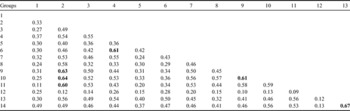
The similarity between the identified groups was tested using the Jaccard similarity index (Table III). Separation of the identified groups (obtained by the dendrogram and confirmed by the PCA) is consistent with results of the Jaccard similarity index which indicates the highest similarity a) between groups 13 and 14, b) among groups 2, 9, 10, 11, c) between 9 and 10; and a high similarity d) between groups 4 and 6. In particular, the high similarity among groups 2, 9, 10, 11 could be linked to the occurrence in all groups of Schistidium antarctici, Syntrichia sarconeurum, Usnea antarctica, Candelariella flava, Xanthoria mawsonii, Physcia caesia and Buellia frigida. The high similarity between groups 13 and 14 suggests they are two different associations belonging to the same alliance and order.
Similarity of the dendrogram groups calculated by the Jaccard similarity index (computed by the software EstimateS, Colwell Reference Colwell2005). Values ≥ 0.6 are given in bold.

Group 12 is isolated from all the other groups, again confirming that it was anomalously nested within the dendrogram.
Floristic classification of Victoria Land vegetation
The International Code of Phytosociological Nomenclature (ICPN) (Weber et al. Reference Weber, Moravec and Theurillat2000) recognizes four principal ranks in the hierarchical system of syntaxa: association, alliance, order and class. An “association (type of stands) is a plant community of definite floristic composition which presents a uniform physiognomy and which is grown in uniform habitat conditions”. Ranks such as “sociation” and “consociation” are not considered under the ICPN, while a subassociation (a rank subordinate to an association but which must be established with reference to the association to which it belongs) is recognized. At least 10 vegetation relevés are required for the original diagnosis of an association or subassociation and that for each proposed association, a relevé must be indicative and serve as the name-bearing type. In Antarctica, local environmental constraints often make it difficult to acquire 10 such relevés and it is proposed here that a minimum of 5 should be required for the diagnosis of associations and subassociations in continental Antarctic regions.
The rules of the ICPN are complex. Considering that the aim here is to provide a useful and easily applicable tool for standardized field measurement and subsequent data analysis and comparison, a simplified nomenclature (easily usable in the field) is proposed.
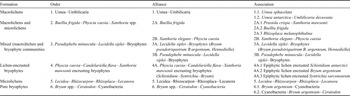
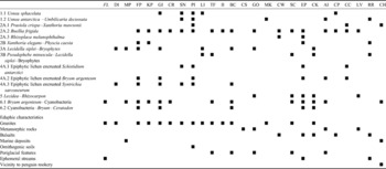
The hierarchical classification of the original data (Fig. 2, Tables I & II), integrated with the results of PCA (Fig. 3) and similarity indices (Table III), permits an elaboration of a floristic classification of the vegetation derived from the average percentage cover of each species (Table I), species frequency (Table II), and the general syntaxonomical scheme (Table IV), organized according to the ICPN rules (Weber et al. Reference Weber, Moravec and Theurillat2000). The distribution patterns of each identified association in the sites sampled in Victoria Land together with some environmental data, such as lithology, occurrence of ornithogenic soils, periglacial features, ephemeral streams and proximity to penguin rookeries/colonies are reported in Table V. These data are referred only to the relevés presented in this paper and do not attempt to cover all the environmental variability of the conditions where these associations may occur.
Scheme of the proposed new floristic classification of Victoria Land vegetation.

Distribution patterns of the vegetation associations in the investigated sites at Victoria Land.

Site acronyms: FL = Fryxell Lake, DI = Dunlop Island, MP = Marble Point, FP = Finger Point, KP = Kar Plateau, GI = Gregory Island, CR = Cape Ross, SN = Starr Nunatak, PI = Prior Island, LI = Lamplugh Island, TF = Tarn Flat, II Inexpressible Island, BC = Boulderclay, CS = Cape Sastrugi, GO = Gondwana, MK = Mount Keinath, CW = Cape Washington, SC = Simpson Crags, EP = Edmonson Point, CK = Cape King, AI = Apostrophe Island, CP = Cape Phillips, CC = Crater Cirque, LV = Luca Vittuari point (unofficial name), RR = Redcastle Ridge, CH = Cape Hallett.
Discussion
The data obtained from field studies in Victoria Land were compared to those available from existing Antarctic literature (Kappen Reference Kappen1985, Wynn-Williams Reference Wynn-Williams1985, Schwarz et al. Reference Schwartz, Green and Seppelt1992, Castello & Nimis Reference Castello and Nimis1995, Smith Reference Smith1999) to develop a proposed standardized system for floristic classification of the vegetation.
The floristic classification proposed here distinguishes six different orders which could be grouped in two main classes of vegetation: a) dominated by lichens (orders 1, 2, 5 of Table IV corresponding to the dendrogram groups 1–6 and 12) (further divided into units dominated by macrolichens - groups 1, 2, and by crustose lichens - groups 3, 4, 5, 6, 12), and b) mainly dominated by bryophytes (orders 3, 4, 6 of Table IV and dendrogram groups 7–14 with the exception of group 12). It is comparable with the main formations described for the vegetation of other continental Antarctic regions (e.g. Smith Reference Smith1988, Melick & Seppelt Reference Melick and Seppelt1997). The proposed new classification groups associations on the basis of floristic composition. The sequence of associations within each alliance emphasis ecological requirements, often indicative of a range of moisture and/or nutrient regimes, as indirectly indicated by PCA (Fig. 3).
The distribution of bryophytes is compatible with a gradient in ground moisture. Recent data on soil properties in different vegetation and permafrost conditions in continental Antarctica (Cannone et al. in press) show that Bryum species, Ceratodon purpureus and Syntrichia magellanica (formerly named Syntrichia princeps) are generally found where ground moisture is relatively high (> 25%), while Schistidium antarctici and Syntrichia sarconeurum generally occur where soil moisture is <13%. However, in many localities in Victoria Land species show adaptation to variable ground moisture conditions (e.g. C. purpureus and B. pseudotriquetrum are able to tolerate also relatively dry conditions according to Selkirk & Seppelt Reference Selkirk and Seppelt1987). At Cape Hallett and some nearby localities, Bryum argenteum occurs in the wettest sites and Syntrichia magellanica in dry sites with ephemeral moisture. Schistidium antarctici occurs in habitats spanning a wide range of substrate moisture levels. Syntrichia sarconeurum appears to be the only consistent indicator of dryer habitats.
The gradient in lichens distribution is complex and is determined in part by substrate characteristics, the availability of nitrogen (as NH4+), the physiological response of individual habitat moisture regime, and in part by latitude.
The Usnea–Umbilicaria order (and alliance) includes the following communities previously described for northern Victoria Land: the Usneetum purum and the Usneetum mixtum (Kappen Reference Kappen1985), and the groups G1 and G2 of the fruticose and foliose lichen subformations (Castello & Nimis Reference Castello and Nimis1995). Similar communities occur in other northerly locations of continental Antarctica (e.g. for the Windmill Islands region of Wilkes Land: Smith Reference Smith1988, Melick et al. Reference Melick, Hovenden and Seppelt1994, Melick & Seppelt Reference Melick and Seppelt1997).
The Buellia frigida–Physcia–Xanthoria alliance and its orders and associations are compatible and may include the communities formerly described within groups G5, G6, G7 of the subformations of crustaceous lichens in Victoria Land (Castello & Nimis Reference Castello and Nimis1995).
An additional order and alliance is characterized by Pseudephebe minuscula, Lecidella siplei and bryophytes, and is separated from the traditional Usnea–Umbilicaria–Pseudephebe alliance. From the dendrogram, this alliance is located close to the bryophyte-dominated communities and may indicate that Pseudephebe has similar moisture requirements to bryophytes and may, therefore, be a potentially useful target species for long-term monitoring of climate change impacts on vegetation, in particular to snow, because it is reliant on snow melt for its water supply.
The Physcia caesia–Candelariella flava–Xanthoria mawsonii encrusting bryophytes order and alliance is compatible with, and may include, the lichen-encrusted bryophytes communities formerly described as G8 (Castello & Nimis Reference Castello and Nimis1995).
The identification of a Lecidea cancriformis–Rhizocarpon–Rhizoplaca–Lecanora order and alliance raises problems concerning both its position within the dendrogram and its representativeness within the classification system. To address this problem it seems appropriate to place it in isolation but representative of the epilithic crustose lichen communities, although investigation is needed to represent adequately its floristic composition and ecological requirements.
The pure bryophytes communities are represented by the Bryum spp.–Ceratodon–Cyanobacteria order and alliance.
Proposals for future research include: a) analysis of the ecological requirements of the proposed syntaxa, particularly for substrata moisture and nutrients, b) assessment of the successional stages to reconstruct patterns of vegetation development and succession, c) inclusion of new study sites and of a wider range of environmental, latitudinal and geographical conditions to increase the representativeness of these data, and d) development of the present objective floristic classification to encompass the vegetation of all continental Antarctica.
Acknowledgements
We wish to thank for their comments and suggestions Prof Ryszard Ochyra and two anonymous reviewers which allowed us to significantly improve this paper. We wish to thank Prof Mauro Guglielmin, the coordinator of the Permafrost and Global Change in Antarctica Project (funded by PNRA), for his scientific cooperation and help in the field. We are grateful to PNRA (Progetto Nazionale Ricerche in Antartide) for their scientific collaboration and logistic support to Nicoletta Cannone.