INTRODUCTION
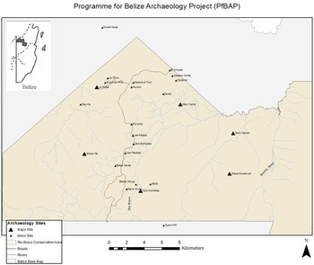
The northwest region of Belize, known as the Rio Bravo Conservation and Management Area (RBCMA), is a 251,000-acre research set-aside located in northwest Belize, owned and operated by the Programme for Belize. The RBCMA is a region of interest for researching all archaeological sites (Figure 1), but especially rural/hinterland communities of the prehistoric Maya. The Programme for Belize Archaeological Project (PfBAP) was established in 1992 to conduct Maya archaeological research in the RBCMA. The PfBAP is positioned to investigate all sizes (or levels of complexity), across the 251,000-acre reserve. The vast expanse of land and years of investigation have allowed the PfBAP to develop an informed platform of field experiences, which serve as the basis for this study. To be clear, northwest Belize is a much larger region than the RBCMA. The broader region, including Blue Creek, generally has received much archaeological research into Maya society including large and small sites alike (Guderjan Reference Guderjan2007, Reference Guderjan2013), but the focus here centers on sites within the RBCMA.
Select Programme for Belize Archaeological Project (PfBAP) sites mentioned in the text. Map by Cortes-Rincon, courtesy of the PfBAP.

Most field research activities have concentrated on the upper 110,000 acres of the property. The smaller settlements often referred to as hinterland or rural communities within the RBCMA have been, and remain, of the greatest investigative interest for the PfBAP. There are numerous hinterland settlements of varying complexity (Valdez Reference Valdez2018), and this study presents several sites/communities that functioned between and in some cases near the larger centers of the region. The communities, defined and discussed below, detail characteristics of small site settlements that reflect past Maya behavior and can be viewed as both practical and ritual.
To date, five significant large ancient Maya centers have been identified within our research area. Additionally, at least six middle-size sites have been documented for the region along with more than 60 small settlements that may be identified as hamlets, households, or rural settlements. Among the many small rural settlements are the sites of Tzak Nab, El Arroyo, Medicinal Trail, Hun Tun, La Obra, Mulch'en Witz, Chawak But'o’ob, Pak'il Nah, Dancer Group, Grupo Agua Lluvia, N950, and Funky Town. These serve as examples of hinterland sites studied in the PfBAP area of northwestern Belize (Adams et al. Reference Adams, Scarborough, Levi, Walling, Dunning, Lewis, Shaw, King, Sullivan, Reese Taylor and Valdez2004a; Cortes-Rincon and Boudreaux Reference Cortes-Rincon and Boudreaux2015; DeFrancisco Reference DeFrancisco, Trein and Valdez2019; Gonzalez and Lorenz Reference Gonzalez, Lorenz, Dodge and Valdez2021; Hyde Reference Hyde2011, Reference Hyde2018; Kotsoglou Reference Kotsoglou, Trein and Valdez2019; Lewis Reference Lewis1995; Scarborough and Valdez Reference Scarborough and Valdez2009; Scarborough et al. Reference Scarborough, Valdez and Dunning2004; Trachman Reference Trachman2007; Valdez Reference Valdez2005, Reference Valdez2014; Walling Reference Walling, Valdez and Houk2011, Reference Walling2018). The designation of sites as large, middle size, or as rural settlements is based on a site size hierarchy within the RBMCA (Adams et al. Reference Adams, Turner, Turner and Ashmore1981). Several of these sites have been described in a number of reports and papers over the last decade or more, and this article will provide the descriptive essentials for each selected site. We will utilize data from several sites to highlight various important characteristics and activities represented in rural communities that may often go unappreciated. The environmental background and setting, to help contextualize the region, have been addressed by several scholars (Beach et al. Reference Beach, Luzzadder-Beach, Krause, Walling, Dunning, Flood, Guderjan and Valdez2015, Reference Beach, Sheryl, Samantha, Tom, Fred, Juan, Sara and Colin2019; Dunning et al. Reference Dunning, Beach, Luzzadder-Beach, Scarborough, Valdez and Dunning2003; Krause et al. Reference Krause, Beach, Luzzadder-Beach, Guderjan, Valdez, Eshleman, Doyle and Bozarth2019), where these concerns are detailed in more scientific terms, and beyond the scope of the present work.
MAYA CIVILIZATION AND RURAL COMMUNITIES
Archaeological investigations of ancient Maya polities continue with much appeal. We must, however, examine the hinterlands for evidence of political activities as part of this research if we are to characterize the amount of political centralization present. To this point, the argument has been made that in centralized polities, elites in lower-order centers do not have the ability to draw the tribute and labor required for large civic projects while the reverse is true in decentralized polities (Cortes-Rincon and Boudreaux Reference Cortes-Rincon and Boudreaux2015). Are the Maya unique in their form of centralized organization? The broad investigations of all levels of Maya society in northwest Belize may provide valuable insights concerning these relationships.
The smaller rural settlements of the ancient Maya had often been viewed by past archaeologists as repeated versions of each other, leading, in some cases, to a reduced perception of complexity, making the visible invisible. Over the last few decades, we have been able to see and document that each site has a specific layout, likely reflecting particular function(s). Many of these communities are now shown to interact through a set of socioeconomic interdependencies, knit together in a complicated areal/regional exchange system in which individual communities harvest or exploit specific resources either raw or refined, the latter entailing degrees of craftsmanship (Lewis Reference Lewis1995; Scarborough and Valdez Reference Scarborough, Valdez, Scarborough, Valdez and Dunning2003, Reference Scarborough and Valdez2009).
Similar to observations noted above, Lamb (Reference Lamb, Hutson and Ardren2020:322) has reported that “Rural settlements have traditionally been viewed in three ways: (1) as homogenous, agrarian-based, and self-sufficient, lacking the social complexity of their urban counterparts; (2) as small populations dependent on nearby urban centers to fulfil their economic and ritual needs; and (3) as passive territories exploited by regional elites” (see also Robin 2012). We agree with Lamb and contend that these notions seem to persist in Maya archaeological research publication. These general notions, however, have been clearly modified or dispelled in the archaeological research of northwest Belize. Yes, there are systems and materials that may be compared and contrasted between urban and nonurban settings without the need of judging the value of one over another. Issues of equality or inequality also have a significant place in the study of rural communities.
There are four essential components herein contained for the PfBAP investigations of rural settlements of Maya civilization in northwest Belize. These components are addressed in the following sections: (1) Hinterland Study Strategies, (2) Rural Settlements, (3) Rural Diversity, and (4) Nonurban Life and Rural Elites. Hinterland Study Strategies includes the purposes and perhaps benefits of studying the rural populations. Definitions of concepts such as rural and hinterland are also discussed and contextualized for this article. In Rural Settlements, we present the various selected sites/locations reported as rural communities and a description of each site. Rural Diversity details as best as possible the type of site or community represented and the function(s) that may be associated with that location. Finally, Nonurban Life and Rural Elites provides a discussion of architecture, material culture, and possible activities (such as ritual) often considered elite and urban, but certainly present in places unexpected by most traditional Maya investigation standards.
We wish to make clear that this research is focused on small sites (or rural localities) as identified and defined for the northwest Belize region. There are, as mentioned above, middle-sized sites away from the more significant centers that can be seen as rural and perhaps representing rural elite occupation/interests. These middle-sized locations are not discussed or generally addressed in this study concerning rurality. We also contend, however, that materials and activities often considered to be elite exist and are defined among the small communities in northwest Belize.
HINTERLAND STUDY STRATEGIES: METHODS, DEFINITIONS, AND VALUE
The PfBAP has utilized survey and mapping strategies, material culture analyses, and theoretical lenses for interpreting aspects of ancient Maya life of the region's rural communities. The field research efforts/strategies range from simple raking, sweeping, and instrument mapping of surfaces to the more complex technological applications of Light Detection and Ranging (LiDAR) and muon tomography. The PfBAP has defined new ways of looking at the ancient Maya, as well as how they interacted across the region (Hyde Reference Hyde2011, Reference Hyde2018; Scarborough and Valdez Reference Scarborough, Valdez, Scarborough, Valdez and Dunning2003; Trachman Reference Trachman2006, Reference Trachman2007). The various techniques and methods utilized in archaeological investigations have proven to be quite effective at elucidating insights concerning ancient life in northwest Belize—from the uncovering of minute features that might otherwise be walked over and/or ignored, to the identification of novel features previously not considered, but discovered through pedestrian survey or mechanized surveys.
The PfBAP has documented five large centers/communities and more than 60 small-to-middle sized settlements in varying distances from each other and often located in differing physical environments. Our investigations into these smaller communities have provided us with an understanding that these communities are different in layout, likely different in productive activities, and not simply carbon copies of each other. A related result of the PfBAP regional investigations has led to the consideration of rural sites as resource specialized communities (Scarborough and Valdez Reference Scarborough, Valdez, Scarborough, Valdez and Dunning2003).
We suggest a few definitions as pertains to the PfBAP research. Provided are working definitions of rural, hinterland, community, site, and settlement. These descriptive terms overlap with Lamb's (Reference Lamb, Hutson and Ardren2020) definitions, but we utilize them with broader application. For our purposes, we do not distinguish between rural and hinterland. The primary reason for not separating these concepts within the RBMCA is that a distinguishing feature (of these terms?) is often the distance from an urban center or the presumed relationship between the smaller sites and their urban counterparts. In our research zone, there is often no significant drop in settlement as one moves from one large center to another. Thus, rural and hinterland are used interchangeably to refer to settlements at a distance from an urban core. We must also emphasize, that whether concerned with hinterland or rural, these small settlements are likely as diverse as urban settings, simply at a smaller scale, but not at less complexity. Other discussions about settlement and what constitutes settlements have been presented with varying opinion in earlier works (e.g., Hutson et al. Reference Hutson, Céline, David, Sarah and Arthur2018; Levi et al. Reference Levi, Boudreaux, Sheumaker, Trein and Valdez2019; Yaeger and Canuto Reference Yaeger, Canuto, Canuto and Yaeger2000).
The use of the terms site, settlement, and community also required definition and description for this study. Sites are locations exhibiting past human behavior and usually represented by material culture. Within the PfBAP, we tend to name sites as the specific locations with particular remains including households, plazuelas, or groups of structures. The broader term of settlement can be used to refer to a site or a larger area that may include several sites and features such as terracing, channelized fields, and other nondomestic structures.
We use the term community to refer to an area that may be comprised of a site, several sites, or other features, that share a social integration. Some communities are implied by their physical layout or the proximity of combined entities e.g., a plazuela or groups adjacent to or near a terraced hillside, or attached basins for presumed processing (as seen at the Medicinal Trail site, among others). While we may alternate the use of community and site, community implies a social construction that helps to define an area for the presumed common good of its constituents. For aspects of rurality, we concur with Lamb (Reference Lamb, Hutson and Ardren2020, Reference Lamb2022) and her definitions of various characteristics or criteria that help demarcate what is rural versus other. Lamb's defined components include spatiality, demography, ecology and landscape use, specialization, as well as health and integration, to name most. These aspects are incorporated into various discussions below concerning rural settlements and rural diversity.
The extensive archaeological investigations of the PfBAP at many rural locales provide us a value of knowing similarities as well as differences between many settlements. This is meant to convey that we have had an opportunity to experience, compare, and contrast the findings of areas known as rural sites from more than two decades of investigations into these sociopolitical entities. From our experiences, we can confidently state similarities and differences in construction, site layout, and observe features that imply certain functional activities. As we progress into discussions of sites/settlements and their descriptions as well as the diversity of rurality, we do so from an informed platform of field experiences. Our combined efforts from the PfBAP provide us with hard data from which to reconstruct ancient Maya behavior. Thus, we will be explicit when interpreting a pattern of recorded data or be clear if we are speculating a potential model of certain behavioral activities.
The study of prehistoric Maya rural populations serves several valuable points of information about the past and perhaps for today. Understanding, or at least gaining insights, about past Maya rural occupations allows us to gain an understanding of what people produced from the land and how they utilized various resources (Marcus Reference Marcus, Lohse and Valdez2004). These studies may also provide insights into sustainability and resilience, as well as political interactions among these smaller communities and between them and the larger centers. There is a great benefit and value in understanding rural populations as they, in our opinion, represent what made Maya civilization possible.
RURAL SETTLEMENTS OF THE RBMCA AND PfBAP
As previously mentioned, there are at least 60 known small sites that are part of the PfBAP. By small sites, we distinguish five large centers versus all other settlements. Of those 60 sites, at least seven qualify as middle-sized, with the majority categorized as small. We must emphasize that middle-sized and small each have overlapping dimensions (such as small middle-sized or larger small sites). An added emphasis is that a middle-sized site may also be rural given its location in relation to the more complex urban centers. Rural or hinterland, for us, has greater significance in terms of distance from urban activities. Other categories of settlements include terms such as barrio (or neighborhood), ward, district, cluster, and even community (Hutson Reference Hutson2016; Levi et al. Reference Levi, Boudreaux, Sheumaker, Trein and Valdez2019). These terms, except for community, represent a wide range of settlement size from the smallest to just below city. Although some of these characteristic types may be found within and/or next to the city.
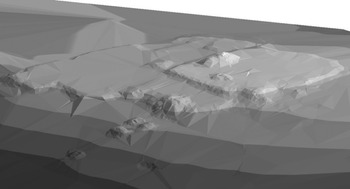
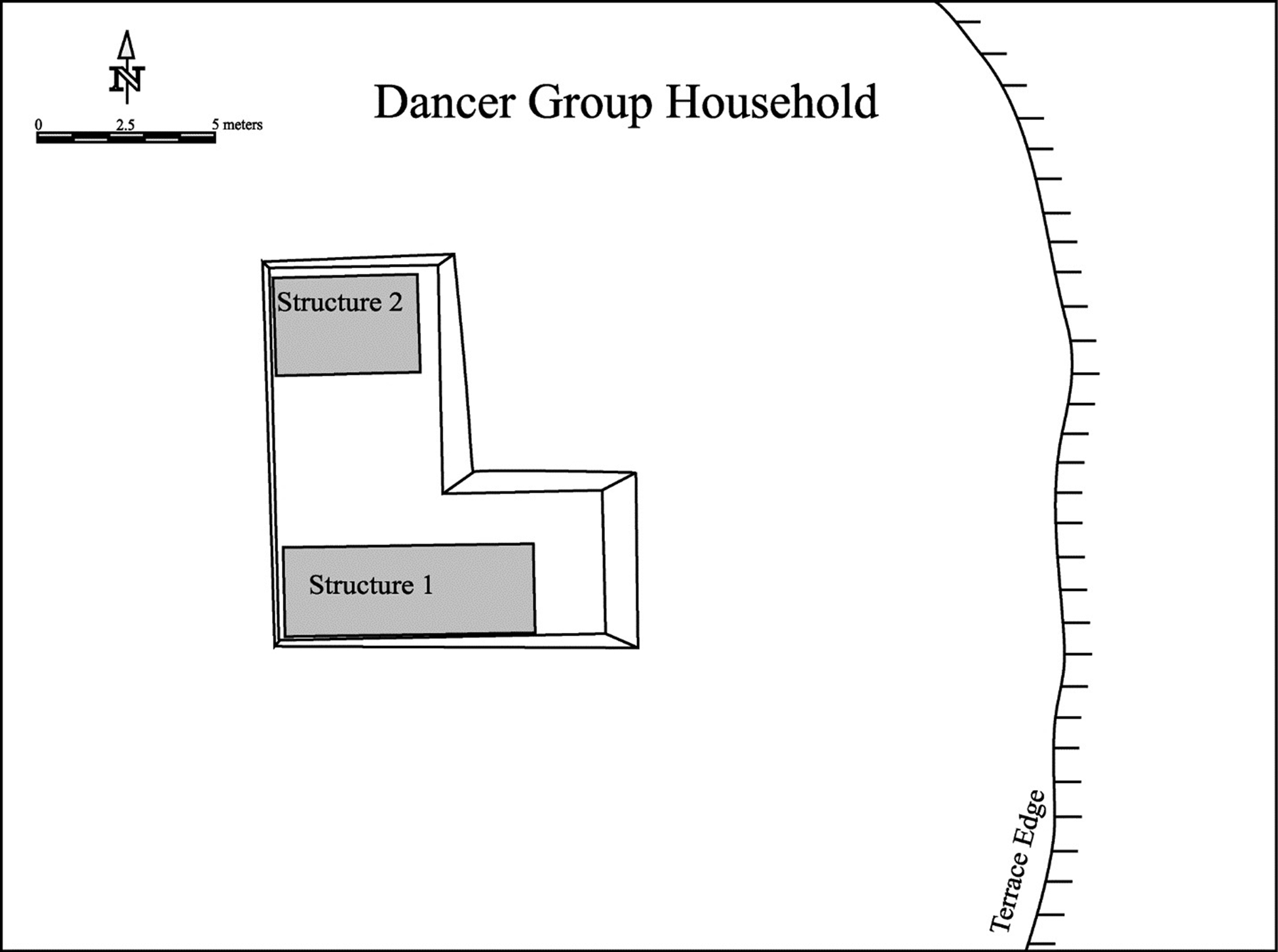
The following described sites, as we identify them for this article, are small communities that have been investigated by, and are part of, PfBAP research. From north-to-south the described sites are: Tzak Naab (Figure 2), El Arroyo, Medicinal Trail, Hun Tun, La Obra, Mulch'en Witz, Chawak But'o’ob, Pak'il Nah, Dancer Group (Figure 3), Grupo Agua Lluvia, North 950, and Funky Town. Each site is only briefly defined or described here as a basic context to more elaborate discussions that follow. Some sites are important here because of layout and features, while other are emphasized for their environmental setting, although all of these aspects are important to each community.
Tzak Naab 3-D map. Map by Anastasia Kotsoglou, courtesy of the Programme for Belize Archaeological Project.

Map of the Dancer Group. Map by Trachman, courtesy of the Programme for Belize Archaeological Project.

To be clear, there are many other rural sites that we do not address in this article including, for example, El Intruso, Cabeza Verde, Gateway, Bolsa Verde, My-Lady, Barba Group, La Milpa North Chico, and other observed localities. In addition to the numerous small rural localities, there are many unnamed sites along various transect surveys of the PfBAP. There are also many middle-sized sites, as mentioned before, that may be identified as rural (or hinterland), and include La Milpa East, Wari Camp, Guijarral, La Milpa North, Dos Barbaras, Say Kah, and Quam Hill among others.
Tzak Naab
The rural site of Tzak Naab is located north of the Rio Bravo Conservation Management Area. The site is approximately six kilometers northwest of La Milpa and found on a karstic hilltop, which is cleared and currently used for cattle grazing. Tzak Naab overlooks the seasonally inundated Dumbbell Bajo, found to the east of the site.
Tzak Naab was constructed on three artificially modified tiers. The uppermost tier has been designated as Tier A. The middle tier is Tier B, and the lowest tier is named Tier C. The site is generally oriented east-west, as based on the architecture. A possible sacbe is suggested as an access-way to the south (Kotsoglou Reference Kotsoglou, Trein and Valdez2019).
El Arroyo
El Arroyo was discovered as a result of surveying a dry stream bed for chert resources, and is comprised of domestic house mounds, lithic work areas, and an absence of monumental architecture (Tovar Reference Tovar, Adams and Valdez1995). There is also an ancient well associated with the site. El Arroyo consists of a group of 15 cobble platforms that once supported perishable structures. The ecology of the immediate area includes secondary or transitional forest growth dominated by tree species such as Santa Maria, Sapodilla, Black Poison Wood, and Mahogany (Nicholas Brokaw, personal communication 2019).
Medicinal Trail
The Medicinal Trail Site is located approximately five kilometers east of La Milpa (Hyde Reference Hyde2011, Reference Hyde2018). The site is named after a tourist trail of the same name near the La Milpa Station of the RBCMA. The Medicinal Trail community consists of extensive settlement and landscape modifications such as terraces, water catchments, and linear features thought to be related to water management/control and intensive agriculture (Hyde Reference Hyde2018). A total of 14 mapped architectural groups have been identified at the Medicinal Trail Community with much of the settlement located across a northeast-southwest trending ridge top.
The settlement of the community varies greatly in terms of size and formal plan. The variation extends from poorly organized informal clusters of low mounds, to quite formal residential groups (Hyde Reference Hyde2011; Hyde and Valdez Reference Hyde, Valdez and Valdez2007). The Medicinal Trail Site is a hinterland/rural community comprised of a few formal courtyard groups (residential and nonresidential), numerous informal clusters of mounds, and multiple landscape modifications and features (Hyde Reference Hyde2011, Reference Hyde2018; Hyde and Valdez Reference Hyde, Valdez and Valdez2007).
Hun Tun
Hun Tun is located about five kilometers from La Milpa and is a modest, commoner community (Dodge Reference Dodge2016; Trein et al. Reference Trein, Dodge and Valdez2015). The site has a varying topography with water management features and agricultural terraces along its southeastern boundary (Dodge Reference Dodge2016). Hun Tun consists of several formal courtyard groups of different size, scale, and likely of different function. Group A is interpreted as the site center and may have served as a ceremonial plaza for the hinterland elite residents of Hun Tun. A notable feature associated with Group A and Structure A-1 is a buried, clay-filled chultun, and a sweathouse (Dodge Reference Dodge2016). The cultural topography of Hun Tun seems to be stratified between the plazuelas. Most of the site includes plazuela groups with relatively humble house mounds.
La Obra
The archaeological site of La Obra is located about 1.2 km northwest of the La Milpa center. The site consists of approximately 28 mounds including several features, two chultuns, and three depressions, all surrounding a larger, two-tiered building and central courtyard on a hilltop. The west and far northeast corner of La Obra may have been possible locations for quarrying, possibly due to the hard, dense limestone found throughout the site (DeFrancisco Reference DeFrancisco, Trein and Valdez2019).
While Structure NE-2 at La Obra was the only building considered with some confidence to be a platform, no clear floors or internal walls were observed in any of the structures. Interestingly, one of the most striking features of the site is its layout. “The appearance of most of the building as platforms rather than abodes combined with the lack of any courtyards or groupings of inward-facing buildings gives the site the appearance of a place that might have served several functions, but at least on the surface does not give the feel of a residential area” (DeFrancisco Reference DeFrancisco, Trein and Valdez2019:72).
Mulch'en Witz
Mulch'en Witz is found roughly one-kilometer northeast of the ancient Maya site of La Milpa. Mulch'en Witz exhibits a high concentration of these subterranean features referred to as chultuneob. Chultuneob are small human-made cavities dug into the limestone bedrock. These human constructed features have been encountered around ceremonial centers as well as near commoner residences. “The spatial distribution of chultuneob at Mulch'en Witz, and their association to platforms, appear to formalize the space and highlight the importance of the chultun's inclusion within the landscape” (Gonzalez and Lorenz Reference Gonzalez, Lorenz, Dodge and Valdez2021:121).
Chawak But'o’ob
Chawak But'o’ob is located towards the southern end of the property, just off the north-south gravel road that cuts through the RBMCA. The site's settlement sprawls across the sloping terrain of the Rio Bravo escarpment with general dimensions of 450 m east-west, by 1.1 km north-south (Hanna and Walling Reference Hanna and Walling2011; Walling et al. Reference Walling, Hanna, Cornish, Coughenour, Taylor, Fox, Trein and Valdez2019). There are more than 350 structures, most less than a meter in elevation, in this rural settlement.
According to Hyde and colleagues (Reference Hyde, Walling and Valdez2019:238), “The discovery of eighth-century maize and other pollen in cores on the floodplain adjacent to the site suggest an economy focused on agrarian pursuits.” A special feature at Chawak But'o’ob is the presence of a formal ballcourt. The construction of this ballcourt, a very well-executed feature, in this hinterland/rural setting seemed at first, peculiar. The site of Chawak But'o’ob provides a special perspective and indication of the overlapping interests of environment and ritual.
Pak'il Nah
Pak'il Nah, a large residential plazuela group, is located approximately 1.2 km east of the site center of Dos Hombres and was comprised of four structures organized around an open plazuela space. Even though the tallest mound (Structure 1) of the group is merely 2.2 m, it is the largest domestic structure in all of the surveyed area east of Dos Hombres. That particular structure was constructed of thick masonry walls that likely supported a vaulted roof. It also had been ritually terminated (unlike the other three associated small platforms) as evidenced by ritual sealing of the doorway, deconstruction of the upper portion of the building, burning, and depositing of red pigment (Trachman Reference Trachman2007). Among other important features of these small sites includes the vegetation within and surrounding the group. There is a blending of vegetation from the nearby bajo zone and that of the aguada margins zone that includes “Escoba palm (Cryosophila argentea) and low-growing vines are mixed with Chicle (Manikara zapota), Ceiba (Ceiba pentandra), Gumbo Limbo (Bursera simaruba) and Allspice (Pimenta dioica) trees. The natural soils are thin organic layers over limestone bedrock with intermittent areas of shallow clay to clay loam” (Trachman Reference Trachman2007:75).
Dancer Household Group
The Dancer Household Group is approximately 1.75 km west of Dos Hombres and is located on the slope of the Rio Bravo Escarpment. The site is comprised of an L-shaped, low platform with two structures resting on a residential terrace (Trachman Reference Trachman2006). Three sets of multiple burials were excavated at the Dancer Group household, one dating to the Late Classic, and two dating to the Late Preclassic. These provide insight into ritual reflective of hinterland/rural activity and belief systems including identity construction.
Grupo Agua Lluvia
Grupo Agua Lluvia, also located on the Rio Bravo Escarpment is located only 150 m southwest of the Dancer Group on the escarpment (Trachman Reference Trachman2007). Placed on a modified knoll, Grupo Agua Lluvia is a plazuela group of five, clustered structures, including a small Late Classic round structure. The site extends east from the escarpment face and has associated with it certain environmental features that allow for the growth of hardwoods. Grupo Agua Lluvia is situated at the head of an upland spring which is directed towards the Dancer Group as well as other nearby households via a system of reservoirs and canals (Trachman et al. Reference Trachman, Farah, Ewing, Murdock, Houk and Valdez2011).
North 950 Site
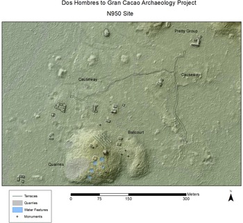
The North 950 Site (Figure 4) is located along a transect that extends from Dos Hombres north-northeast towards Gran Cacao (DH-to-GC Transect). This site is among several newly documented rural sites along the transect. The North 950 site is a small site situated atop a modified knoll 1 km northeast of Dos Hombres. It comprises an elite, open, courtyard group with a shrine, associated with a cave to its north, and a small ritual ballcourt (Cortes-Rincon and Boudreaux Reference Cortes-Rincon and Boudreaux2011). East of the cave is a platform that supports two small superstructures and a chultun (Cortes-Rincon Reference Cortes-Rincon2013). To the north of this platform, there are artificial water channels cut into the bedrock leading down the slope and north and east of the N950 hill, the slope was artificially terraced. Located amongst the terracing on the north side of the knoll are two small inter-connected cave openings, a modest monument at the base of the hill, and a rural sacbe system (Boudreaux Reference Boudreaux2013; Ports Reference Ports2015a). Excavations at this site indicate that it was established in the Late Preclassic and occupied until its abandonment during the Terminal Classic. The items recovered included locally produced as well as imported materials, such as obsidian from the highlands of Guatemala. The focus of the proposed research here is the sacbe system, specifically the intersection of two sacbeob northeast of the site, where Sacbe 78, which runs east-west, terminates at its eastern end in Sacbe 99, which runs north-south. To the west and south of that juncture is a very flat area (ca. 4,500 m2) with two long, low mounds adjacent to Sacbe 78 that could have housed stalls. Excavations within them yielded organic material that decomposed in a very dark layer. A drainage system linked to three water basins lies to the northeast of Sacbe 78. This space and its associated structure resemble some of the causeway termini identified as markets at Caracol (Chase et al. Reference Chase, Chase, Terry, Horlacher, Chase and King2015).
N950 Site. Map by Cortes-Rincon, courtesy of the Programme for Belize Archaeological Project.

Funky Town
Funky Town is a large residential group located at a hill along the DH-to-GC Transect, the upper portion of the hill appears to have been culturally modified. “It is a very peculiar group as there is no formal structure placement, this group was nicknamed Funky Town. Structures 7, 8, 9, and 10 are arranged around a courtyard and these have been heavily damaged by numerous tree falls. There are two structures outside of this group which are not aligned in any particular way” (Cortes-Rincon and Boudreaux Reference Cortes-Rincon and Boudreaux2011).
RURAL/HINTERLAND DIVERSITY: DEFINED AND INFERRED
The diverse and complex hinterland, or rural communities, known across the Maya lowlands are extensively represented in northwest Belize. The communities of northwest Belize are as diverse as any in the Maya region and serve as a great starting place for viewing the range of ancient Maya settlement diversity and the potential diversity of community function. This range of diversity in northwest Belize includes aspects such as settlement structure, community function, and community social/political constructs (Hyde et al. Reference Hyde, Walling and Valdez2019; Schwartz and Falconer Reference Schwartz, Falconer, Schwartz and Falconer1994; Zaro and Lohse Reference Zaro and Lohse2005). Consideration of diversity of function are known from other locales in northern Belize including Colha and Kichpanha, located along the old Northern Highway (Valdez Reference Valdez2007). Some of the north Belize communities reflect what we reference as resource specialized sites (RSS). These RSS are the subject of recent research, and help to partially explain aspects of functional details, polity survival, economics, and so forth (Scarborough and Valdez Reference Scarborough, Valdez, Scarborough, Valdez and Dunning2003). The specific potential of interpreting RSS as an integral system of Maya polities is provided in the conclusions section of this article with an example from highland Guatemala.
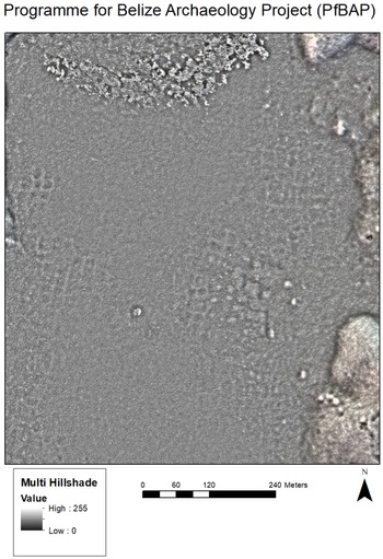
Interest in the livelihood of the prehistoric residents of northwest Belize remains a significant research concern for reconstructing ancient Maya behavior. Smaller sites and rural settlements provide some of the best insights about the integrated nature of prehistoric Maya life. The RBMCA area is a highly complex system of microenvironments that provide and provided varied resources leading to broad settlement (Hyde Reference Hyde2011; Scarborough and Valdez Reference Scarborough, Valdez, Scarborough, Valdez and Dunning2003; Trachman Reference Trachman2007; Valdez Reference Valdez2005). Some occupied areas are sources of chert used for making stone tools while other areas were better suited for agricultural activity; and in several cases specialized agricultural efforts such as hillside terracing and channelized fields (Figure 5). Many areas, although settled and active, have not readily revealed the primary focus of activity.
Photograph of channelized fields taken from LiDAR imagery. Courtesy of the Programme for Belize Archaeological Project and the NW Belize LiDAR Consortium.

The PfBAP research has provided an opportunity to view topographically different areas for types of settlement. Intensification of production in northwest Belize is evident from the remnants of channelized fields as on the lower parts of certain rivers, including the Rio Bravo and Irish Creek. There exists also the development of slope terracing on numerous hillsides and knolls. A fascinating revelation (or realization) concerns the density of population in this northwestern Belize region, which was far greater than that found today, indicating the high potential of productivity for the region (Adams et al. Reference Adams, Robichaux, Valdez, Houk, Mathews, Demarest, Rice and Rice2004b). All of these aspects connect into economic interests of the ancient Maya and the political interactions that kept the region generally stable for long periods of time.
There are two significant aspects of ancient sociopolitical life for the northwest Belize ancient Maya. First are the practical aspect of subsistence, resilience, and sustainability. The second aspect involves more abstract issues that include ritual and identity. Both components involve a potential diversity of expression revealed only if we are willing to see it. We always deal with the factual materials of artifacts and features, but the interpretation(s) of these findings often remain constricted.
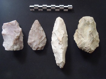
The sites identified above provide, in varying detail, clues to ancient Maya life in the region. El Arroyo, for example, was a source of chipped chert stone tools (Figure 6). The more distant site of Chawak But'o’ob revealed the extent of ritual (and community identity) through the ballcourt in a rural setting. The variation of site function and adaptation is extensive as initially reported by Scarborough and Valdez (Reference Scarborough, Valdez, Scarborough, Valdez and Dunning2003). The variability in site function is likely related to the environment(s) occupied by a given site/settlement. Thus, the notion of RSS reflects the available resources from a given location. El Arroyo again serves as a specific case in which the available chert resources allowed for productive specialization. For horticultural practices, we find features that include aguada, pozas, terracing, channelized fields, chultuneob, wells, stone alignments, and chich mounds (of varied sizes), all of which may be utilized in some capacity. We must remember that horticulture does not mean only food production, but the manipulation of flora that may provide items for medicinal needs, practical interests (e.g., fibers, thatching, and cotton), perhaps seedlings, condiments, and even decorative plants (Hughbanks Reference Hughbanks2006; Sheets Reference Sheets2002). Some of the features that we associate with horticulture may have served for soil manipulation; others like channelized fields may have been associated with more than water control including, for example, potential gates for fish and turtle farming. Additionally, perhaps far-reaching for now, is the consideration of animal maintenance for food, pets, or as sources of other needs including fur, feathers, and bone, among other useful animal parts. It seems plausible that the Maya kept some animals and bred them as a source of food including perhaps, deer, rabbits, pacas, monkeys, certain reptiles, and birds. The latter (birds) could have served, for example, as a source of meat, eggs, feathers, or just as pets (including the symbology associated with some birds). It is likely that the rural communities would have been the location of most, if not all, of these productive activities to be found in the complex civilization of the ancient Maya.
Programme for Belize Archaeological Project (PfBAP) lithic examples. Photograph by Bruce Templeton, courtesy of the PfBAP.

We find that, contrary to general notions that rural communities are “all” somehow involved in food production, that many were likely far more involved in other productive activities including stone tool making, pottery production, mining, textile production, and shell bead production. It is also likely that some rural communities—Tzak Naab and La Obra are possible candidates—may have been involved in activities that did not produce physical artifacts, but delivered other interests that might include,e for example, performance or spiritual activity, mentioned here as a suggestion since we do not have hard evidence (Ingalls and Yaeger Reference Ingalls and Yaeger2022).
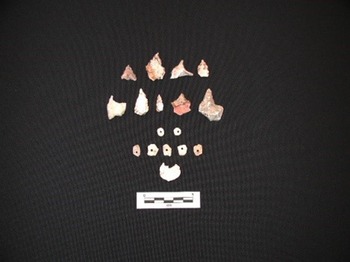
Grupo Agua Lluvia, for example, managed an upland spring water system that fed multiple reservoirs and canals (Trachman et al. Reference Trachman, Valdez, Ardren and Hutson2006). The system is clearly located in and tracks along a residential area of the Rio Bravo Escarpment and would have served to provide water for several households situated along these residential terraces. This household site also participated in producing rough shell beads, as numerous shell bead blanks and lithic perforators were recovered at the site (Figure 7).
Shell beads and perforators. Photograph by Trachman, courtesy of the Programme for Belize Archaeological Project.

Most of these physically productive activities resulted in items that were exchanged in various ways, but a common mechanism would have been marketplaces. Marketplaces accommodating special events were present at all levels of Maya society, with activity proportional to the size of the site (King Reference King2015; Scarborough and Valdez Reference Scarborough and Valdez2009). Much of this discussion addresses the first point above as the practical for subsistence and sustainability. The second interest, that of ritual and identity are also present in rural communities with the obvious remains seen in ballcourts and burials, among other features. The not-so-evident is also present through implied or implicit symbolism that material remains seem to indicate for these remote areas (Hyde et al. Reference Hyde, Walling and Valdez2019).
Specialized material resources may be exchanged as required, but intercommunity special events associated with ballcourts or astronomical alignment architecture are also found at rural sites, such as Chawak But'o’ob (Walling Reference Walling, Valdez and Houk2011) and Quincunx (Zaro and Lohse Reference Zaro and Lohse2005). These, in turn, allow for participation in greater intercommunity solidarity and exchange (Scarborough and Valdez Reference Scarborough and Valdez2009; Valdez and Scarborough Reference Valdez and Scarborough2013; see also Ingalls and Yaeger Reference Ingalls and Yaeger2022). “The builders of the humble Late Classic agrarian site of Chawak But'o’ob, Belize embedded within their constructions and landscape modifications complex ideological references that parallel symbolism in evidence at much larger sites. The findings impact our long-standing assumptions about differences in sophistication between the rural and urban peoples of Late Classic Maya culture” (Walling Reference Walling, Valdez and Houk2011:260, Reference Walling2018). The research at the Chawak But'o’ob ballcourt complex (Figure 8) and other areas of the ancient hinterland community indicates the existence of a sophisticated interplay of environment and ideology. It is the intersection of landscape, hydrology, and architecture that points to the mythological underpinnings of Maya commoner ritual (Gonlin and Lohse Reference Gonlin and Lohse2007) that only partially overlap those in evidence in ancient urban contexts. PfBAP investigations located other rural ballcourts, including one at the North 950 site along the DH-to-GC Transect (Ports and Cortes-Rincon Reference Ports, Cortes-Rincon, Trein and Valdez2019). The symbolism associated with these courts is also manifest in the movement of water through them, among other qualities (Walling Reference Walling, Valdez and Houk2011, Reference Walling2018).
Ball court area of Chawak But'o’ob. Image courtesy of Stanley Walling and the Programme for Belize Archaeological Project.

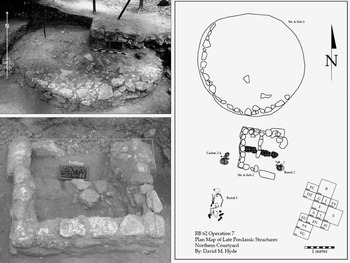
Another aspect of ritual and/or identity is found in the many burials uncovered in the rural settlements. Group A at Medicinal Trail is a place of ritual activity represented by burials and early symbolic constructions. As Hyde (Reference Hyde2014:124) reports, “In the Late Preclassic there was a ceremonial precinct under the Northern Courtyard that consisted of a round structure (Structure A-Sub-1) and a T-Shaped structure (Structure A-Sub-2) about one-half meter apart from each other. The round structure is approximately 3.5 m in diameter, 40 cm tall, and consists of three to four courses of cut stone masonry that taper slightly inward as it moves from bottom to top. No postholes, plaster surface, or masonry architecture were found on top of the round structure suggesting that the platform was exposed and therefore not likely residential (i.e., Aimers et al. Reference Aimers, Powis and Awe2000). We believe the round structure was used for ritual performances, perhaps for the community. Similar structures have been documented at various Maya sites (e.g., San Lorenzo; Ingalls and Yaeger Reference Ingalls and Yaeger2022). The site of Hun Tun included a sweathouse feature at Structure A-1 (Dodge Reference Dodge2016), similarly reported at Ceren (McKee Reference McKee and Sheets2002), providing some insight to ritual and identity activity at a small rural community.
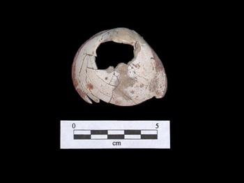
Another interesting find providing specific data related to ritual and identity comes from the Dancer Group near Dos Hombres. A burial of a young female was uncovered with artifacts and features that may address identity, gender, and status among the nonurban Maya. A bivalve shell pendant located near the center of the child's remains may have been hanging from the waist similar to that which was reported by de Landa to have been placed on a child to signify female gender during a life stage ritual (Tozzer Reference Tozzer1941). It seems that gender may have been socialized through the use of material culture symbols as a means of social reproduction (Trachman Reference Trachman2006; Trachman and Valdez Reference Trachman2006). As also reported, “the Dancer Household mortuary deposits come to life when viewed in light of the ethnohistoric and comparative archaeological data. Determining the sex of child skeletal material is very difficult, especially in the poor conditions found in the tropical forests of the Maya lowlands. There is also the problematic assumption that sex equals gender. The possibility of using material culture media as identity producing indicators of gender, not sex, in child mortuary contexts at the Dancer Group is a realistic possibility” (Trachman Reference Trachman2006).
Related to both practical and ritual interests, and another aspect of rural diversity, is the identification and recording of caves and cave features. Caves and water features have been identified near the North 950 site and McNatt (Reference Mcnatt1996) noted that caves were important to the Maya, as they had ritual connotations and were associated with life, death, and a connection to the underworld. Caves also were used for a variety of functions such as sources of drinking water, sources of “virgin water” for rituals, religious rites, burials, ceremonial dumps, or simple places of refuge (Ports Reference Ports2015b, Reference Ports, Cortes-Rincon, Trein and Valdez2019).
Again, we find that the rural or hinterland settlements in northwest Belize provide examples of diversity and complexity in material culture, architecture, features, ritual, and symbology. We can see here the value and importance in continuing to investigate the rural Maya, as they are not a homogenous or monolithic group supporting the large urban centers, but rather provide the diversity that is Maya civilization.
NONURBAN LIFE AND RURAL ELITES
With a long history of Maya archaeological research in the region, we are positioned to consider aspects of nonurban life that helped make Maya civilization possible. Some of the contents herein provided serve as an opportunity for informed speculation that we believe to be a starting point for many a fruitful investigation. With this in mind, we present thoughts about possible replication of activities often thought of as defining urban centers, but are easily found among rural communities as well.
Nonurban life was most likely involved in a daily routine that would have been familiar to urban residents. The normal activities of subsistence, maintenance, and perhaps ritual are all manifested in some manner in the nonurban settings. While specific activities between the urban and the rural may have differed, the events of daily tasks are in short, the same. We would contend that rural daily life was more intimate in certain ways because of the close proximity between rural social members, whether of the same family or of a neighborhood and their productive activities. The diversity of environments (a mosaic of microenvironments) found among rural communities would have provided for exposure to an array of activities and perhaps a direct sharing of knowledge. In the urban setting, similar exposure would likely be found at the marketplace; but then again, rural populations may have had their turn to attend markets as needed. It is the diversity of the rural inhabitants, in their village plan/layout, their mode of subsistence, and their abilities in ritual expression that allowed them to “be the same” as their urban counterparts.
We grant that many urban expressions were more elaborate and larger than rural counterparts including the construction of larger buildings and features: elite palaces versus a rural stone house, temples versus shrines, tombs versus “elite” burials or crypts. The smaller material culture items may also be more extensive in urban settings, but artifacts such as jade, obsidian, and polychrome pottery are also found throughout the rural communities, even if in lesser quantities. Thus, nonurban life included items seen and found in urban settings, but in a different quantitative measure. Rural life (i.e., nonurban life) may have been more similar and more familiar between the two extremes than often described by many archaeologists.
The sites of Medicinal Trail, Chawak But'o’ob, Tzak Naab, the Dancer Group, N950, Pak'il Nah and the others previously discussed each had rituals, caches, burials, or a termination deposit that mimic similar finds in an urban core whether La Milpa, Dos Hombres, or Gran Cacao, among others. It is, we suspect, more an issue of scale than meaning that separates these characteristics for urban versus rural.
A term that has been used when addressing larger developments/constructions in rural settings, or the presence of a crypt rather than simple burial is Hinterland Elites. It seems likely that heads of households and others with limited power may have risen to serve roles similar to their counterparts from the big cities. These rural elites may have managed the local productive capabilities of their community or served to organize community projects and may have also served to orchestrate ritual activities in these areas distant from the urban core (see also Lamb Reference Lamb2022). While much of this may seem like speculation, it is based on years of data gathering and seeing first- hand what would have been simply discounted even just a few decades ago.
Many, perhaps all, of the sites discussed in this article, and even those not discussed due to other limitations, have much to offer about what we would traditionally label as elite. From elaborate burials, to shrine construction, caching, and other features we see with every mapping and excavation endeavor, it is clear that the rural Maya people were as complex as their urban neighbors. The hinterland elite defined themselves on their own terms utilizing symbols and material culture similar to their urban counterparts through architecture, access to exotic items, adornments, and physical modifications.
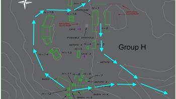
The ballcourts at Chawak But'o’ob (Walling Reference Walling, Valdez and Houk2011, Reference Walling2018) and the N950 site along the Dos Hombres-to-Gran Cacao Transect (Ports and Cortes-Rincon Reference Ports, Cortes-Rincon, Trein and Valdez2019) serve as physical examples of replicating what we traditionally see as urban only. At Medicinal Trail (Hyde Reference Hyde2011, Reference Hyde, Walling and Valdez2019) is the proposed seat of power represented early on by construction of the T-shaped “throne” (Figure 9) and at Hun Tun is the ritual burial of a chultun and the construction of a sweathouse at Structure A-1. Trachman's (Reference Trachman, Valdez, Ardren and Hutson2006, Reference Trachman2007; Trachman and Valdez Reference Trachman, Valdez, Ardren and Hutson2006) research at the Dancer Group near Dos Hombres clearly demonstrates the effort of the nonurban to self-express, demonstrate a self-defined identity, and provide clear indicators of gender identity (Figure 10). Each of these aspects, in addition to their physical components, also carry significant symbolic value for both the actor and the community. Clearly, the study of the ancient rural Maya provides us all with far more extensive knowledge about the workings of Maya society in the past. The level of productivity, complexity, and connectedness (to myth, symbol, and ritual), are far more elaborate and extensively present in these rural areas than previously ever believed. What may be missing in our analysis is the extent to which the urban centers may have been paying attention to, perhaps even courting, the rural populations (see also Lemonnier and Arnauld Reference Lemonnier and Arnauld2022).
Medicinal Trail Preclassic structures, round platform, and rectangular throne. Map and photographs by David Hyde, courtesy of the Programme for Belize Archaeological Project.

Dancer Group shell artifact reflecting gender. Photograph by Trachman.

RURAL/HINTERLAND COMMUNITIES: SUMMARY AND CONSIDERATIONS
The archaeological study of the rural ancient Maya provides some of the best and direct information on how Maya civilization operated. We consider whether the prehistoric relationships between varying communities is top-down or bottom-up. Even when contemplating the relationship(s) between modest rural sites and large urban centers there was more likely a blending of these top-down and/or bottom-up aspects.
The sociopolitical-economic interactions between various ancient Maya communities reflect concerns for polity survival. Reconstructions of those prehistoric relationships between communities of varying size and complexity are based on evidence from mapping, excavation, and material culture analysis. It seems likely that the practice(s) of resource specialized communities provided for very stable polities due the development of community interdependency. Consideration must also be given to the similar artifact categories at the range of sites represented in a given region of the Maya world. If considering economics, markets, and the like, we suggest interdependence as a mutual enterprise such as the trading and/or exchanging of resources (even ceramics, but of different form and function).
Our perspective on rural communities is that they operated both independently and in unison. The RSS as we have presented for northwest Belize include sites where certain activities were likely duplicated. This means that although several communities may have access to similar resources, they probably coordinated production that would be a most positive effect for each. A hypothetical example or scenario of this (RSS) model is as follows:
Two or three rural communities each have access to good quality clay for pottery production. Each community becomes a pottery production specialized location, but each community produces different forms. While each site has the materials and talent to produce a full array of pottery (e.g., plates, bowls, and jars), they do not! Rather, one community specializes in plates, another in making jars, and the third community focusses on bowls. Why? In this model, competition that may be detrimental to each location is reduced or eliminated. They can trade internally exchanging bowls for jars and plates or plates for bowls and jars. This also now creates an interdependency between the ceramic producing communities. Each can then go to the marketplace (King Reference King2015; Reina and Hill Reference Reina and Hill1978) to trade their wares. If this kind of model is replicated across a region, such as northwest Belize, the need for market exchange (King Reference King2015) and the interdependencies developed may lead to very stable polities and regions.
This modeling as suggested for the ancient Maya is not just fabrication, but an effective system utilized historically in highland Guatemala (Reina and Hill Reference Reina and Hill1978). In our case, it is through rural studies that we can see how all of the social units are connected. From practical applications of daily production to concerns of ritual, myth, and identity, the rural communities provide insights into interactions that may be difficult to ascertain from the study of large centers only. It is the study of rural Maya that allows for understanding ancient Maya civilization with all of its highly complex components.
RESUMEN
La región noroeste de Belice, conocida como Rio Bravo Conservation and Management Area (RBCMA), es una reserva de interés para investigar las comunidades del interior de los mayas prehistóricos. Las comunidades del interior o campesinas de la RBCMA son tan diversas y complejas como cualquier otra de las tierras de la región baja maya. El Programme for Belize Archaeological Project (PfBAP) del noroeste de Belice proporciona varios datos para observar e interpretar las interacciones mayas antiguas en la región. Con más de 25 temporadas de investigaciónes arqueológicas en la región, los investigadores de PfBAP están bien preparados para presentar y considerar aspectos de la vida no urbana que ayudaron hacer posible la civilización maya. PfBAP utiliza estrategias de prospección y mapeo, análisis de cultura material, LiDAR e intereses teóricos para evaluar la vida de los antiguos mayas en las áreas campesinas de la región. Los sistemas sociopolíticos (y / o interacciones) también se proponen para los campesinos mayas prehistóricos. Entre las comunidades campesinas investigadas se encuentran Tzaak Nab, Medicinal Trail, Hun Tun, Chawak But'o’ob, el Dancer Group, así como otros sitios / áreas dentro del RBCMA. Hay cuatro componentes esenciales aquí contenidos para las investigaciones de PfBAP de los asentamientos campesinos de la civilización maya en el noroeste de Belice. Estos cuatro intereses son: (1) Estrategias de estudio en el interior, (2) Asentamientos campesinos, (3) Diversidad campesina y (4) Vida no urbana y élites campesinas. Donde es posible, se discuten las relaciones sugeridas entre comunidades de diferente tamaño y complejidad. Las manifestaciones de producción, identidad e igualdad también se definen si procede y se integran en la discusión de las funciones asociadas con la ruralidad.
Nuestros hallazgos indican que la ruralidad no implica una falta de sofisticación muchas veces atribuida a los centros más grandes, sino un sistema dinámico, altamente complejo de identidad, reproducción y agencia. Cualquiera que sea la función específica en la que las comunidades campesinas hayan participado, está claro que proporcionaron la energía y combustible que impulsaron la civilización maya.
ACKNOWLEDGMENTS
We first extend our thanks to the Institute of Archaeology, National Institute of Culture and History (NICH), and the Institute's Director, Dr. John Morris for his continued interest, support, friendship, and for our annual permit to conduct archaeological research in Belize. The property owners, Programme for Belize, are graciously acknowledged for allowing us access to archaeological remains on the property. We are especially assisted by Mr. E. Romero and Mr. R. Pacheco in Belize City and Mr. V. Rodriguez at the La Milpa Station. The Programme for Belize Archaeological Project and all of its members—too many to name and we fear leaving someone off the list—continue to inspire us and encourage us to consider the great range of possibilities in all of our research interests. We have received wonderful help and acceptance by many members of the San Felipe and Blue Creek communities where we share our home-away-from-home. We each also thank our home institutions for continued support and encouragement for our research in northwest Belize. The imagery in Figure 5 was kindly permitted for publication here by way of the Northwestern Belize LiDAR Consortium; The National Science Foundation (BCS #1550204, 0924501, and 0924510; S. Luzzadder-Beach and T. Beach PIs; CNH #1114947 N. Brokaw, PI); University of Texas (UT) College of Liberal Arts; The C.B. Smith Sr. Centennial Chair in US-Mexico Relations; The Beach Geography and the Environment Labs at UT Austin (T. Beach and S. Luzzadder-Beach, Directors); The Center for Archaeological and Tropical Studies at UT Austin and The Programme for Belize Archaeological Project (F. Valdez, Jr., Director); The Center for Social Science Research at UT Tyler and The Maya Research Program (T. Guderjan, Director); Institute of Archaeology, NICH Belize; and the National Center for Airborne Laser Mapping (NCALM), Houston.