Introduction
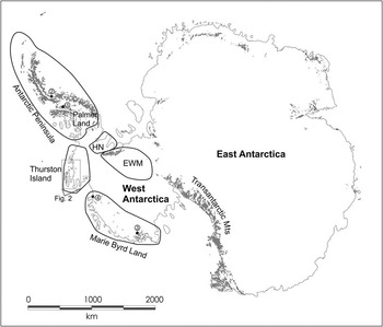
West Antarctica consists of five major and geologically distinctive crustal blocks (Storey et al. Reference Storey, Dalziel, Garrett, Grunow, Pankhurst and Vennum1988), which formed part of the Palaeozoic and Mesozoic continental margin of Gondwana (Fig. 1).
Map of Antarctica showing the main crustal blocks of West Antarctica. EWM: Ellsworth-Whitmore Mountains, HN: Haag Nunataks. 1: North-west Palmer Land location of Mount Eissenger, Pegasus Mountains, Campbell Ridge and Sirius Cliffs, 2: Joerg Peninsula, 3: Fosdick Mountains, Marie Byrd Land, 4: Walgreen Coast, Marie Byrd Land.
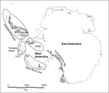
The Thurston Island and Marie Byrd Land crustal blocks have geological histories that, in many respects, resemble that of the adjacent Antarctic Peninsula crustal block (Fig. 1). However, in other respects their geological histories more closely resemble that recorded in parts of New Zealand (e.g. Korhonen et al. Reference Korhonen, Saito, Brown, Siddoway and Day2010), which was formerly situated outboard of Marie Byrd Land, prior to Gondwana break-up (Yakymchuk et al. Reference Yakymchuk, Brown, Brown, Siddoway, Fanning and Korhonen2015). The relative position of the crustal blocks of West Antarctica and any geological relationships between them remain poorly understood (e.g. Veevers Reference Veevers2012), largely as a result of the absence of reliable geochronology on key units, particularly on Thurston Island.
Palaeozoic and Mesozoic magmatic arc rocks in the Antarctic Peninsula, Thurston Island and Marie Byrd Land preserve an important record of subduction before, during and after Gondwana break-up (e.g. Leat et al. Reference Leat, Storey and Pankhurst1993). Recent geochemical and geochronological research from the Antarctic Peninsula (Millar et al. Reference Millar, Willan, Wareham and Boyce2001, Reference Millar, Pankhurst and Fanning2002, Riley et al. Reference Riley, Flowerdew and Whitehouse2012, Vaughan et al. Reference Vaughan, Leat, Dean and Millar2012) and from Marie Byrd Land (Mukasa & Dalziel Reference Mukasa and Dalziel2000, Korhonen et al. Reference Korhonen, Saito, Brown, Siddoway and Day2010, Yakymchuk et al. Reference Yakymchuk, Brown, Brown, Siddoway, Fanning and Korhonen2015) have allowed an improved understanding of their geological histories and how they are related. The geochemistry and geochronology of Thurston Island magmatism has been documented by Leat et al. (Reference Leat, Storey and Pankhurst1993) and Pankhurst et al. (Reference Pankhurst, Millar, Grunow and Storey1993), respectively. The geochronology presented by Pankhurst et al. (Reference Pankhurst, Millar, Grunow and Storey1993) was based on whole rock and mineral 40Ar/39Ar, K-Ar and Rb-Sr dating, which are not as reliable for dating magmatic events as U-Pb zircon data recently used from the Antarctic Peninsula and Marie Byrd Land.
This paper presents new U-Pb geochronology from Thurston Island and includes samples from the main known magmatic units. The results are compared with the previous geochronology (Pankhurst et al. Reference Pankhurst, Millar, Grunow and Storey1993), and the implications of these on correlations along the proto-Pacific margin of Gondwana are discussed.
Geological background and previous geochronology
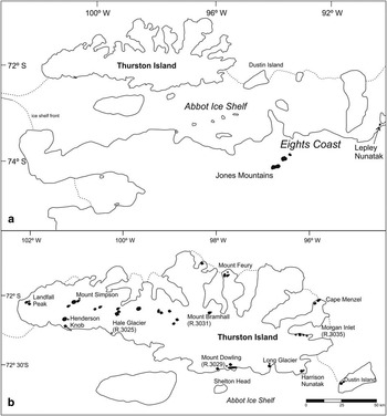
Thurston Island is 240 km long and up to 100 km in width (Fig. 2a); any rock exposure is limited and geological contacts are rare. The geology of Thurston Island, its associated minor islands, the adjacent Eights Coast and Jones Mountains (Fig. 2a) have previously been described by Craddock et al. (Reference Craddock, White and Rutford1969), Craddock (Reference Craddock1972), Lopatin & Orlenko (Reference Lopatin and Orlenko1972), Rowley (Reference Rowley1990), Storey et al. (Reference Storey, Pankhurst, Millar, Dalziel and Grunow1991), Leat et al. (Reference Leat, Storey and Pankhurst1993), Pankhurst et al. (Reference Pankhurst, Millar, Grunow and Storey1993) and Kipf et al. (Reference Kipf, Mortimer, Werner, Gohl, van den Boggaard, Hauff and Hoernle2012).
Map of Thurston Island and the adjacent Eights Coast. b. Map of Thurston Island and places referred to in the text.
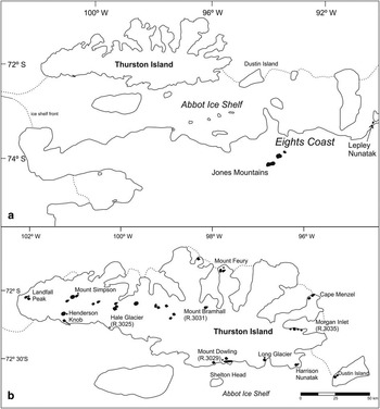
Thurston Island and the adjacent mainland that forms the crustal block consists of a basement sequence of variably tectonized calc-alkaline igneous rocks recording Pacific margin magmatism of Carboniferous to Late Cretaceous age (White & Craddock Reference White and Craddock1987, Leat et al. Reference Leat, Storey and Pankhurst1993, Pankhurst et al. Reference Pankhurst, Millar, Grunow and Storey1993, Kipf et al. Reference Kipf, Mortimer, Werner, Gohl, van den Boggaard, Hauff and Hoernle2012). These magmatic rocks are overlain, in places, by Miocene alkali basalts, which were erupted following the cessation of subduction along this margin. Pankhurst et al. (Reference Pankhurst, Millar, Grunow and Storey1993) divided the basement geology of Thurston Island into seven groups on the basis of field relationships and geochronology. Their groups were: i) Late Carboniferous granitic basement, ii) Late Palaeozoic/Early Mesozoic gabbro–diorite magmatism, iii) Early Jurassic granite magmatism, iv) Jurassic (?) volcanism, v) Late Jurassic granite magmatism, vi) Early Cretaceous gabbro–granite magmatism, and vii) Mid to Late Cretaceous magmatism.
Late Carboniferous granitic basement
Craddock (Reference Craddock1972) suggested that the whole of Thurston Island is underlain by medium- to high-grade metamorphic rocks of pre-Jurassic age, although Lopatin & Orlenko (Reference Lopatin and Orlenko1972) suggested a more restricted area of basement gneiss. Field observations described by Pankhurst et al. (Reference Pankhurst, Millar, Grunow and Storey1993) indicate that the basement gneisses occur in eastern Thurston Island in the vicinity of Morgan Inlet and Cape Menzel (Fig. 2b). The primary lithology is a granodiorite-leucogranite gneiss unit and was interpreted by Leat et al. (Reference Leat, Storey and Pankhurst1993) to be part of an ensialic magmatic arc. The magmatic protolith at Morgan Inlet was dated by whole rock Rb-Sr at 309±5 Ma (Pankhurst et al. Reference Pankhurst, Millar, Grunow and Storey1993).
Late Palaeozoic/Early Mesozoic mafic magmatism
The gabbro/diorite intrusive rocks, which were identified as a separate group by Lopatin & Orlenko (Reference Lopatin and Orlenko1972) crop out in the northern part of central and eastern Thurston Island. The primary lithology is hornblende gabbro, which is typically medium grained and undeformed. Pankhurst et al. (Reference Pankhurst, Millar, Grunow and Storey1993) had difficulty dating the gabbros with K-Ar (hornblende and biotite) and 40Ar/39Ar (biotite), yielding ages in the range (240–220 Ma), but in view of the pristine igneous nature of these rocks and absences of subsequent deformation or metamorphism, they concluded that crystallization was ~237±6 Ma.
Early Jurassic granites
Coarsely crystalline, porphyritic pink granites crop out at the adjacent Jones Mountains on the mainland (Fig. 2a) beneath a Cenozoic unconformity and were dated by Pankhurst et al. (Reference Pankhurst, Millar, Grunow and Storey1993) using whole rock Rb-Sr (198±2 Ma), although a muscovite separate yielded a younger K-Ar age of 183±5 Ma.
Jurassic volcanism
The Jurassic volcanic rocks of Thurston Island are calc-alkaline lavas and pyroclastic rocks that vary in composition from basalt to rhyolite. Pankhurst et al. (Reference Pankhurst, Millar, Grunow and Storey1993) encountered difficulty in dating the volcanic rocks as a result of low-grade metamorphism and the extensive development of secondary minerals. Nevertheless, six samples from a sequence of andesitic tuffs and banded rhyolite flows at Mount Dowling (Fig. 2b) yielded a whole rock Rb-Sr errorchron with an age of 164±9 Ma. A separate felsite unit gave a considerably older Rb-Sr whole rock age of 182±2 Ma.
Basaltic–rhyolitic volcanic rocks are also reported from the Jones Mountains, but no age information exists.
Late Jurassic granite magmatism
The western and southern parts of Thurston Island are largely composed of homogeneous, pink porphyritic granites (White & Craddock Reference White and Craddock1987) and they represent the most widespread magmatic event on Thurston Island.
Pankhurst et al. (Reference Pankhurst, Millar, Grunow and Storey1993) dated several granitic plutons using Rb-Sr, K-Ar and 40Ar/39Ar techniques. They identified ages in the range 153–138 Ma, with a peak at ~144 Ma. The plutons are granite–granodiorite in composition, with rare, more dioritic compositions (Leat et al. Reference Leat, Storey and Pankhurst1993).
Early Cretaceous gabbro–granite magmatism
Eastern Thurston Island and the adjacent islands of the Eights Coast (Fig. 2a) are characterized by rocks that are typically more mafic than those exposed in the west (White & Craddock Reference White and Craddock1987). They are gabbro–diorite in composition and were dated by Pankhurst et al. (Reference Pankhurst, Millar, Grunow and Storey1993) using Rb-Sr and K-Ar (biotite) methods and typically yielded ages in the range 127–121 Ma, although biotite from a gabbro at Dustin Island (Fig. 2b) yielded a younger age of 110 Ma, which was taken to mark the final stage of Early Cretaceous magmatism on Thurston Island.
Mid to Late Cretaceous magmatism
A separate, identifiable magmatic episode is exposed in the Jones Mountains, where dominantly felsic (dacite–rhyolite) lavas and tuffs crop out, along with associated mafic–silicic dykes (Leat et al. Reference Leat, Storey and Pankhurst1993). Three separate suites of samples were dated by Pankhurst et al. (Reference Pankhurst, Millar, Grunow and Storey1993) using Rb-Sr (whole rock). Their results were variable, but yielded ages in the range 102–89 Ma, although Pankhurst et al. (Reference Pankhurst, Millar, Grunow and Storey1993) urged caution in their reliability and suspected Rb-Sr systems may have been reset.
Geochronology and Hf isotope geochemistry
This study
Six samples were selected from the Thurston Island crustal block in an attempt to represent the broad range of magmatic rocks and events that are exposed across the region. The selected samples should permit robust correlations to be made with the neighbouring crustal blocks of West Antarctica and further along the proto-Pacific margin of Gondwana.
Analytical techniques
U-Pb geochronology was carried out using the Cameca IMS 1280 ion microprobe, housed at the NORDSIM isotope facility, Swedish Museum of Natural History (Stockholm) and the Sensitive High Resolution Ion Microprobe (SHRIMP) at The Australian National University, Canberra.
Zircons, separated by standard heavy liquid procedures, were mounted in epoxy and polished to expose their interiors. They were imaged by optical microscopy and cathodo-luminesence (CL) prior to analysis. The CL images were used as guides for analysis targets because they reveal the internal structure of the grains. The analytical methods using the NORDSIM facility closely followed those detailed by Whitehouse & Kamber (Reference Whitehouse and Kamber2005). U/Pb ratio calibration was based on analysis of the Geostandard reference zircon 91500, which has a 206Pb/238U age of 1065.4±0.6 Ma, and U and Pb concentrations of 81 and 15 ppm, respectively (Wiedenbeck et al. Reference Wiedenbeck, Alle, Corfu, Griffin, Meirer, Oberli, Vonquadt, Roddick and Spiegel1995). At the SHRIMP facility, the analytical method followed that outlined by Williams (Reference Williams1998). Calibration was carried out using zircon standards mounted together with the samples (mostly AS-3; Paces & Miller Reference Paces and Miller1993).
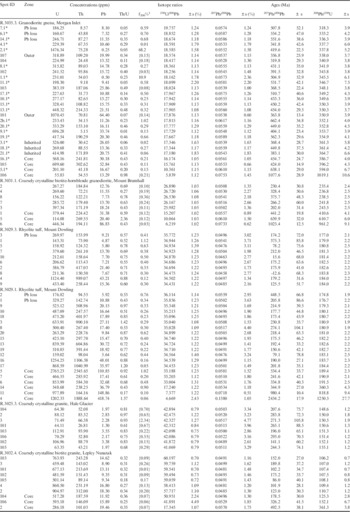
Common lead corrections were applied using a modern day average terrestrial common lead composition (207Pb/206Pb=0.83; Stacey & Kramers Reference Stacey and Kramers1975) where significant 204Pb counts were recorded. Age calculations were made using Isoplot v.3.1 (Ludwig Reference Ludwig2003) and the calculation of concordia ages followed the procedure of Ludwig (Reference Ludwig1998). The results are summarized in Table I.
U-Pb zircon ion microprobe analyses.
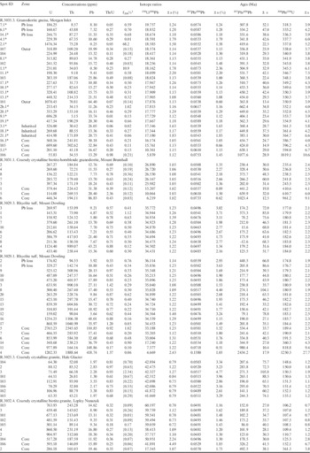
1 Percentage of common 206Pb estimated from the measured 204Pb. Data is not corrected for common Pb, except for values given in parentheses.
*Analysed by SHRIMP.
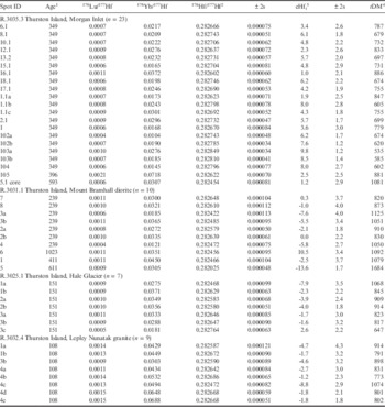
Hf isotopic determinations were made using a 266 nm Merchantek Nd:YAG laser attached to a VG Axiom multi-collector inductively coupled mass spectrometer at the NERC Isotope Geosciences Laboratory, UK. Analyses were carried out, where possible, on top of the original ion-microprobe-generated pit, so that Hf analysis could be paired with different stages of zircon growth. Where this was not possible, CL images were used to identify areas of zircon interpreted to have the same age. The Hf analytical method follows that described by Flowerdew et al. (Reference Flowerdew, Millar, Vaughan, Horstwood and Fanning2006). Repeat analysis of 91500 monitor standard yielded 176Hf/177Hf 0.282300±77 (n=32). The results are summarized in Table II.
Lu-Hf isotope analyses.
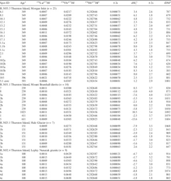
1 Age sample or portion of grain analysed.
2 Values using a modified Thirlwall & Walder (Reference Thirlwall and Walder1995) doping method for correcting the interfering 176Yb (Flowerdew et al. Reference Flowerdew, Millar, Vaughan, Horstwood and Fanning2006).
3 Calculated using Lu decay constant of 1.865 x 10⁻¹¹ (Scherer et al. Reference Scherer, Münker and Mezger2001), 176Hf/177Hf and 176Lu/177Hf (CHUR) values of 0.282785 and 0.0336, respectively (Bouvier et al. Reference Bouvier, Vervoot and Patchett2008).
4 Depleted mantle model ages were calculated using present day 176Hf/177Hf and 176Lu/177Hf values of 0.28325 and 0.0384, respectively (Griffin et al. Reference Griffin, Belousova, Shee, Pearson and O’Reilly2004).
Morgan Inlet
Sample R.3035.3 is a granodiorite gneiss from Morgan Inlet (Fig. 2b) and is considered to be from the oldest exposed magmatic unit on Thurston Island. Pankhurst et al. (Reference Pankhurst, Millar, Grunow and Storey1993) recorded a Rb-Sr whole rock age of 309±5 Ma (mean square weighted deviation (MSWD) 3.4, initial 87Sr/86Sr: 0.7040) for a series of gneiss samples including sample R.3035.3.
R.3035.3 contains large (200–500 μm), stubby, but prismatic (aspect ratio typically 2:1) grains. Under CL, a complex zircon internal structure is apparent (Fig. S1 found at http://dx.doi.org/10.1017/S0954102016000341). Most zircons comprise an inner portion displaying fine-scale growth typical of crystallization from a magma during intrusion, but also a ubiquitous, thin outer (typically 30 μm) zone which cuts across growth zones of the inner portion. The CL character of the outer portion is also different, with a gradient from strongly to weakly luminescent from the zircon inner zone to the rim.
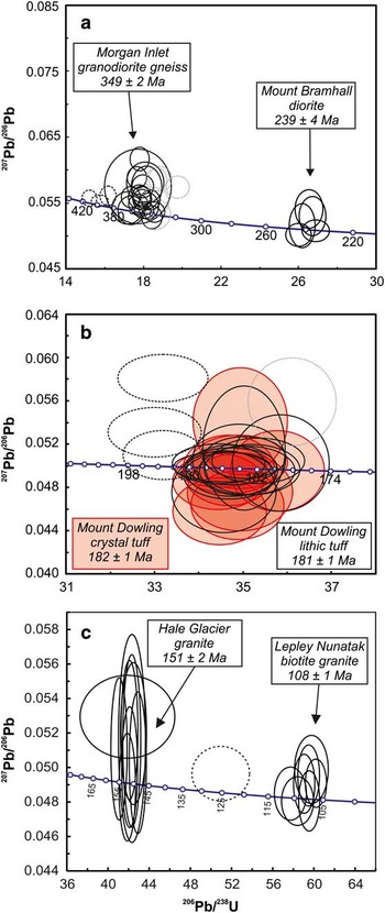
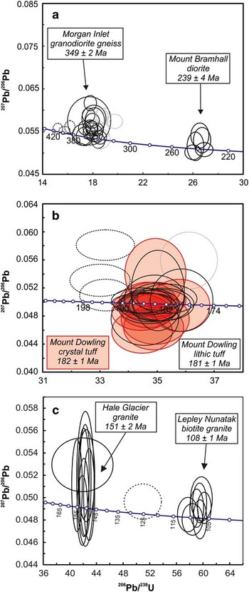
Twenty-eight analyses of zircon grains (Table I) include one that has lost radiogenic Pb (318 Ma) and four older ages that are interpreted to represent pre-Carboniferous inherited zircon (1019–386 Ma). The remaining 206Pb/238U ages range from 365–331 Ma, with a weighted mean of 347±4 Ma, but outside analytical error as indicated by an MSWD of 3.3. It is notable that the two analyses of the thin outer zircon phase give ages indistinguishable from those of the inner core. This range could be attributed either to minor Pb loss at the younger end due to the effects of penecontemporaneous metamorphism or to inheritance of a precursor magmatic phase at 365–360 Ma, or indeed to both effects. On this basis, 15 ages give a weighted mean of 349±2 Ma with a MSWD of 1.1, and this is taken as best representing the crystallization age of the granitoid protolith (Fig. 3a).
Concordia diagrams for analysed zircons from the Thurston Island crustal block a. Morgan Inlet granodiorite gneiss and Mount Bramhall diorite, b. Mount Dowling rhyolites, c. Hale Glacier granite and Lepley Nunatak granite.
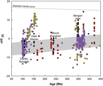
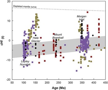
Nineteen Hf isotopic analyses on the 349 Ma portions from 17 grains yield positive ɛHf values which range between 1.0±2.1 and 9.8±1.2, and a weighted average of 6.2±1.2 (Fig. 4), which corresponds to a depleted mantle model age of ~700 Ma. This indicates that the gneisses, although modestly juvenile (as indicated by the low 87Sr/86Sri ratio and low εNdi values of -0.7 to +2.1; Pankhurst et al. Reference Pankhurst, Millar, Grunow and Storey1993) had involved some older crust during petrogenesis, consistent with the minor occurrence of inherited zircons of Early Palaeozoic and Proterozoic age.
Hf evolution diagram from zircon grains from sites in the Thurston Island crustal block. Black diamonds: Thurston Island (this study), purple squares: Marie Byrd Land (Korhonen et al. Reference Korhonen, Saito, Brown, Siddoway and Day2010, Yakymchuk et al. Reference Yakymchuk, Siddoway, Fanning, McFadden, Korhonen and Brown2013, Reference Yakymchuk, Brown, Brown, Siddoway, Fanning and Korhonen2015), olive green squares: New Zealand (Scott et al. Reference Scott, Cooper, Palin, Tulloch, Kula, Jongens, Spell and Pearson2009), red squares: Antarctic Peninsula (Flowerdew et al. Reference Flowerdew, Millar, Vaughan, Horstwood and Fanning2006). The grey band represents the crustal evolution for the Haag Nunataks gneisses with a 176Lu/177Hf of 0.015 (Flowerdew et al. Reference Flowerdew, Millar, Curtis, Vaughan, Horstwood, Whitehouse and Fanning2007).
Mount Bramhall
Medium grained, weakly deformed, diorite/granodiorite from Mount Bramhall (Fig. 2b) previously yielded hornblende (K-Ar) and biotite (K-Ar, 40Ar/39Ar, Rb-Sr) mineral cooling ages of 237±6 Ma and ~228 Ma, respectively (Pankhurst et al. Reference Pankhurst, Millar, Grunow and Storey1993).
Sample R.3031.1 is a diorite from Mount Bramhall and is the same sample which yielded a 225±6 Ma K-Ar biotite cooling age reported by Pankhurst et al. (Reference Pankhurst, Millar, Grunow and Storey1993). Separated zircons are typically 200 μm prisms with aspect ratios of 3:1 (Fig. S1). The internal structure is generally simple with growth zoning often with a less luminescent outer zone. Rare zircon cores are rounded and have a CL character that is different from the surrounding rim. Five analyses from zircons with the growth-zoned texture yield a weighted mean of the 206Pb/238U ages of 239±4 Ma with a MSWD of 1.9 (Fig. 3a), which is considered to date the intrusion and is consistent with the K-Ar hornblende age reported by Pankhurst et al. (Reference Pankhurst, Millar, Grunow and Storey1993). Inherited cores have 206Pb/238U ages of 411±8, 611±12 and 961±18 Ma.
Seven Hf isotope analyses from portions of five separate ~ 239 Ma grains yield ɛHf values which range between 0.3±3.7 and 7.6±4.0. The average of the analyses of -2.6±2.5 (Fig. 4), which corresponds to a depleted mantle model age of ~950 Ma, indicates that older crust was involved in the petrogenesis of the diorite, consistent with initial 87Sr/86Sr ratios of ~0.7067 and negative εNdi of ~-3.7 (Pankhurst et al. Reference Pankhurst, Millar, Grunow and Storey1993).
Mount Dowling
Zircons were separated from two of the volcanic rock samples which yielded a 164±9 Ma whole rock Rb-Sr age (Pankhurst et al. Reference Pankhurst, Millar, Grunow and Storey1993). R.3029.1 is a crystal lithic tuff and sample R.3029.3 is a fine grained crystal tuff. Both rocks are rhyolitic in composition and are characterized by embayed quartz grains. Zircons from both samples have similar characteristics typical of felsic volcanic rocks; they are small (<100 μm), prismatic (5:1 ratio) and have CL characteristics (Fig. S1) that are consistent with having crystallized from a magma (Corfu et al. Reference Corfu, Hanchar, Hoskin and Kinny2003).
Sample R.3029.1 yields a weighted mean of the 206Pb/238U ages of 181±1 Ma with a MSWD of 0.9 when analysis 2, interpreted to have suffered recent Pb loss, is excluded from the age calculation (Fig. 3b). Textural evidence for older inherited zircons as is evident from cores in the CL images (Fig. S1) and these cores are older, yielding ages at ~350, 980 and 2460 Ma. Sample R.3029.3 yields an indistinguishable age to R.3029.1 of 182±1 Ma with a MSWD of 1.0 and lacks discernible inheritance in the CL images (Fig. S1) nor any evidence from the ages obtained from the individual zircon grains.
Hale Glacier
Pankhurst et al. (Reference Pankhurst, Millar, Grunow and Storey1993) dated a megacrystic, pink, biotite granite from the Hale Glacier area, which gave a Rb-Sr whole rock age of 142±5 Ma, which is in agreement with their K-Ar biotite cooling age of 144±4 Ma. The Hale Glacier granite is part of the Late Jurassic/Early Cretaceous granite magmatism of Pankhurst et al. (Reference Pankhurst, Millar, Grunow and Storey1993).
Sample R.3025.3 from Hale Glacier, dated here, is a pink, megacrystic biotite granite. Zircons are typically 200–300 µm prisms with 3:1 aspect ratios and display diffuse growth and sector zoning under CL, textures which are typical of crystallization in granitoid magmas. Zircon inheritance was not evident from the CL images (Fig. S1). Eight analyses from eight grains yields a weighted mean of the 206Pb/238U ages 151±2 Ma with a MSWD of concordance of 2.4 (Fig. 3c).
Seven Hf isotopic analyses from three grains yield ɛHfi values that range between -7.9±3.5 and 2.6±2.2 (Fig. 4). The resulting average of -2.4±2.6 corresponds to a depleted mantle model age of 860 Ma, and indicates that some older crust was involved in the petrogenesis of the Hale Glacier granite.
Lepley Nunatak
Lepley Nunatak is the easternmost exposure on the Eights Coast (Fig. 2a) and is characterized by calcic granodiorite and coarsely crystalline, biotite granite. These rocks have yielded 40Ar/39Ar and K-Ar biotite ages of 89±1 Ma and 87±2 Ma, respectively (Pankhurst et al. Reference Pankhurst, Millar, Grunow and Storey1993).
Sample R.3032.4 is biotite granite and was selected for U-Pb analysis. Zircons are typically 200 µm squat prisms with fine-scale growth and diffuse sector zoning under CL (Fig. S1) and also display textural evidence for inherited grains preserved as irregular CL-dark cores. Seven analyses from the growth-zoned portions of seven separate grains yields a weighted mean of the 206Pb/238U ages of 108±1 Ma with a MSWD of 2.2 (Fig. 3c), which is interpreted to date the intrusion.
Eight Hf isotopic analyses from the ~108 Ma portions of three zircons yield ɛHfi values which range between -8.8±3.5 and -1.2±2.3. An average ɛHfi of -2.9±2.0 (Fig. 4) and depleted mantle model age of 860 Ma confirms involvement of old rocks in their petrogenesis, and was indicated by the numerous inherited zircons in this sample.
Revised chronology of Thurston Island, correlations along the Gondwana margin and Hf isotopes
Following the U-Pb geochronology carried out as part of this study, the following revisions can be made to the tectonic and magmatic evolution of the Thurston Island crustal block.
Devonian–Carboniferous magmatism
New data presented here has significantly revised the geological development of Thurston Island. The similarity in age between the ~349 Ma granodioritic orthogneiss at Morgan Inlet and granodioritic rocks from western Marie Byrd Land (Fig. 1) suggest that they may be correlatives. Korhonen et al. (Reference Korhonen, Saito, Brown, Siddoway and Day2010) dated several granitoids from the Fosdick Mountains area (Marie Byrd Land; Fig. 1) that yielded Carboniferous ages of 358±8, 350±10, 343±8 Ma and also dated Cretaceous-age magmatism with zircon cores of ~355 Ma. Korhonen et al. (Reference Korhonen, Saito, Brown, Siddoway and Day2010) interpreted the ~350 Ma Carboniferous event to be the result of partial melting of the Devonian (~375 Ma) Ford granodiorite suite.
Yakymchuk et al. (Reference Yakymchuk, Brown, Brown, Siddoway, Fanning and Korhonen2015) reported a broader range of ages for the Ford granodiorite suite (375–345 Ma), but with two distinct magmatic episodes. An older suite (~370 Ma) was interpreted to be the result of mixing of a juvenile magma with metaturbidites of the Swanson Formation, whilst the younger suite (~350 Ma), which overlaps in age with the Morgan Inlet gneisses, were interpreted to have a greater contribution from paragneisses of the Swanson Formation or anatexis of the Ford granodiorite suite (Korhonen et al. Reference Korhonen, Saito, Brown, Siddoway and Day2010).
The ɛHfi data of the ~350 Ma granodiorites from the Ford Ranges of Marie Byrd Land is in the range +2 to -5 (Yakymchuk et al. Reference Yakymchuk, Brown, Brown, Siddoway, Fanning and Korhonen2015), whereas the granodioritic gneiss from Thurston Island has ɛHfi in the range +10 to +2 (Fig. 4). This discrepancy suggests that the Thurston Island magmatism was considerably more juvenile than that in western Marie Byrd Land. The values from the Morgan Inlet gneisses are, however, in close agreement with those obtained from New Zealand where ~ 350 Ma magmatic zircons yielded ɛHfi values of +7 to +2 (Scott et al. Reference Scott, Cooper, Palin, Tulloch, Kula, Jongens, Spell and Pearson2009; Fig. 4).
Early Carboniferous magmatism or metamorphism has not been recognized on the adjacent Antarctic Peninsula (Riley et al. Reference Riley, Flowerdew and Whitehouse2012). There is a minor metamorphic event at ~330 Ma (Millar et al. Reference Millar, Pankhurst and Fanning2002), but Riley et al. (Reference Riley, Flowerdew and Whitehouse2012) demonstrated that this event was likely to have been restricted to the northern Antarctic Peninsula, although it potentially may coincide with a more widespread event (346±4 Ma) in the Deseado Massif of southern Patagonia (Pankhurst et al. Reference Pankhurst, Rapela, Loske, Marquez and Fanning2003).
Triassic magmatism
The U-Pb results presented here date granitoid (diorite/granodiorite) magmatism at Mount Bramhall (Fig. 2b) at 239±4 Ma. This magmatism is potentially part of a Triassic event that is widely exposed across the southern Antarctic Peninsula (Palmer Land). Millar et al. (Reference Millar, Pankhurst and Fanning2002) published magmatic and metamorphic ages from Campbell Ridge, Mount Eissenger, Pegasus Mountains and Sirius Cliffs (Fig. 1) that fall in the age range 230–220 Ma. Riley et al. (Reference Riley, Flowerdew and Whitehouse2012) and Flowerdew et al. (Reference Flowerdew, Millar, Vaughan, Horstwood and Fanning2006) also reported widespread Triassic magmatism and metamorphism in the Joerg Peninsula (Fig. 1) area of Graham Land (236±2 and 224±4 Ma).
Triassic magmatism is known from the Kohler Range and Mount Isherwood in the Walgreen Coast (Fig. 1), i.e. the adjacent part of Marie Byrd Land to Thurston Island (Pankhurst et al. Reference Pankhurst, Leat, Sruoga, Rapela, Márquez, Storey and Riley1998, Mukasa & Dalziel Reference Mukasa and Dalziel2000). Korhonen et al. (Reference Korhonen, Saito, Brown, Siddoway and Day2010) also document inherited, small (<200 μm) Triassic zircons from Cretaceous-age granitoids in Marie Byrd Land. Indirect evidence for Triassic magmatism is widespread in New Zealand as metasedimentary rocks within numerous terranes contain abundant ~240 Ma detrital zircons (e.g. Wysoczanski et al Reference Wysoczanski, Gibson and Ireland1997, Adams et al. Reference Adams, Campbell and Griffin2008, Scott et al. Reference Scott, Cooper, Palin, Tulloch, Kula, Jongens, Spell and Pearson2009). Triassic (and late Permian) granite–rhyolite magmatism is also widespread in northern Patagonia (e.g. Pankhurst et al. Reference Pankhurst, Rapela, Fanning and Márquez2006).
Jurassic magmatism
Silicic tuffs from Mount Dowling (Fig. 2b) have been dated here at 182–181 Ma, some 20 m.y. older than the age proposed by Pankhurst et al. (Reference Pankhurst, Millar, Grunow and Storey1993). The new age is consistent with the ages of major Gondwana break-up magmatic events of the Chon Aike, Karoo and Ferrar provinces (Riley & Knight Reference Riley and Knight2001). Elsewhere along the proto-Pacific margin in Marie Byrd Land, evidence for Early–Middle Jurassic magmatism is limited. Korhonen et al. (Reference Korhonen, Saito, Brown, Siddoway and Day2010) report just a single inherited zircon grain at 181±11 Ma from a Cretaceous-age granite in the northern Fosdick Mountains (Fig. 1), but there are no reported Jurassic volcanic rocks from Marie Byrd Land. Although Adams (Reference Adams1987) does report a Rb-Sr (biotite) age of 165±2 Ma from a granite near Mount Morgan, this was considered to be a potentially reset age.
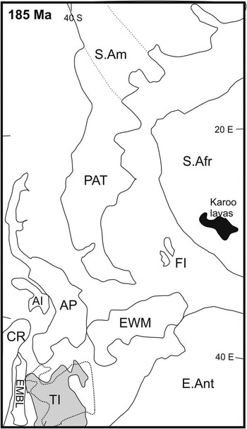
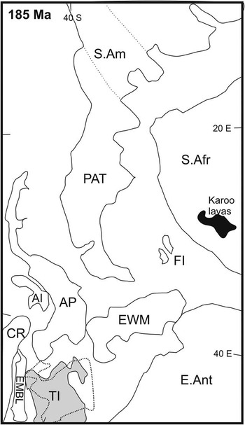
Further north along the margin, the Antarctic Peninsula has multiple occurrences of silicic volcanism at ~183 Ma, particularly in Palmer Land. The Mount Poster and Brennecke formations of southern Palmer Land (Fig. 1) form part of the extensive Chon Aike Province (V1 event; Pankhurst et al. Reference Pankhurst, Riley, Fanning and Kelley2000). The Chon Aike Province of Patagonia and the Antarctic Peninsula has been described by Pankhurst et al. (Reference Pankhurst, Leat, Sruoga, Rapela, Márquez, Storey and Riley1998, Reference Pankhurst, Riley, Fanning and Kelley2000) who identified three distinct volcanic episodes (V1: ~183 Ma, V2: ~170 Ma, V3: ~155 Ma). The Mount Poster and Brennecke formations of the southern Antarctic Peninsula (Palmer Land) have been dated at 183.4±1.4 Ma (Mount Poster Formation; Hunter et al. Reference Hunter, Riley, Cantrill, Flowerdew and Millar2006) and 184.2±2.5 Ma (Brennecke Formation; Pankhurst et al. Reference Pankhurst, Riley, Fanning and Kelley2000) and overlap in age with the Mount Dowling volcanism of Thurston Island. Lithologically, the silicic volcanism from Thurston Island is akin to the dominantly silicic tuffs and ignimbrites of Palmer Land, where associated mafic volcanism is rare (Riley et al. Reference Riley, Curtis, Flowerdew and Whitehouse2016). The age information favours a pre-break-up reconstruction which places the Thurston Island crustal block in a rotated position and one where Thurston Island was juxtaposed with the southern Antarctic Peninsula (Fig. 5). Both Veevers (Reference Veevers2012) and Elliot et al. (Reference Elliot, Fanning and Laudon2016) propose a rotated position for the Thurston Island crustal block at ~180 Ma, although Veevers (Reference Veevers2012) propose a 180° rotation and Elliot et al. (Reference Elliot, Fanning and Laudon2016) a 90° rotation. Either rotation scenario place the Mount Dowling silicic volcanic rocks more adjacent to the silicic formations of the southern Antarctic Peninsula (Fig. 5).
Gondwana Pacific margin reconstruction at ~ 185 Ma (Veevers Reference Veevers2012). The dashed line reconstruction position of Thurston Island is from Elliot et al. (Reference Elliot, Fanning and Laudon2016). E.Ant: East Antarctica, S.Am: South America, PAT: Patagonia, S.Afr: South Africa, FI: Falkland Islands, EWM: Ellsworth-Whitmore Mountains, AP: Antarctic Peninsula, AI: Alexander Island, CR: Chatham Rise, EMBL: Eastern Marie Byrd Land, TI: Thurston Island.
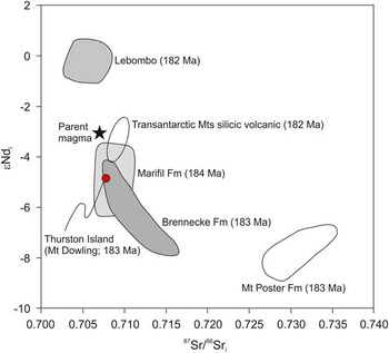
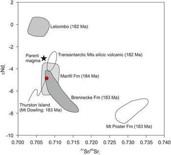
Isotopically (Sr-Nd), the silicic volcanic rocks from Mount Dowling are close in composition (Fig. 6) to the rhyolitic tuffs of the Brennecke Formation (Riley et al. Reference Riley, Leat, Pankhurst and Harris2001) and also the V1 (~183 Ma) equivalent rhyolitic tuffs in Patagonia, the Marifil Formation (Pankhurst et al. Reference Pankhurst, Riley, Fanning and Kelley2000). The contemporaneous Mount Poster Formation of Palmer Land is, however, isotopically distinct (Fig. 6) to all other Early Jurassic volcanic rocks of the Gondwana margin and has been attributed by Riley et al. (Reference Riley, Leat, Pankhurst and Harris2001) to significant upper crustal contamination as a result of its long-lived caldera setting and is considered to be a localized petrogenetic feature.
87Sr/86Sr versus εNd for Early Jurassic silicic volcanic rocks from Mount Dowling on Thurston Island in comparison to rhyolitic volcanic rocks from the V1 episode of the Chon Aike Province (Marifil, Mount Poster and Brennecke formations), Lebombo volcanic rocks, Transantarctic Mountains (Riley et al. Reference Riley, Leat, Pankhurst and Harris2001).
Late Jurassic magmatism is confirmed from the Hale Glacier area (Fig. 2b), with a U-Pb age of 151±2 Ma recorded here from a pink, megacrystic granite, although it is significantly older than the 142±5 Ma age of Pankhurst et al. (Reference Pankhurst, Millar, Grunow and Storey1993). They also dated granitoids from Landfall Peak, Henderson Knob, Mount Simpson and Long Glacier (Fig. 2b), which gave Rb-Sr ages in the range 153–144 Ma. The Late Jurassic–Early Cretaceous granitoids crop out extensively in the western and southern parts of Thurston Island and may represent part of a compound batholith (Leat et al. Reference Leat, Storey and Pankhurst1993).
Late Jurassic magmatism on the Antarctic Peninsula is rare, with Leat et al. (Reference Leat, Scarrow and Millar1995) not reporting any granitoid magmatism from this age. However, Early Cretaceous plutonism at ~141±2 Ma is reported from north-west Palmer Land (Vaughan & Millar Reference Vaughan and Millar1996) and may mark the onset of a major magmatic event during the mid-Cretaceous.
Late Jurassic–Early Cretaceous magmatism is also rare in Marie Byrd Land, although along the eastern margin of the Ford Ranges (Fig. 1) a series of high level, small plutons has been dated in this period (Rb-Sr, K-Ar; Adams Reference Adams1987). Korhonen et al. (Reference Korhonen, Saito, Brown, Siddoway and Day2010) record no Late Jurassic magmatism from the northern Ford Ranges area (Fig. 1) of Marie Byrd Land and identified no inherited grains from this period in the Late Cretaceous granitoids. Kipf et al. (Reference Kipf, Mortimer, Werner, Gohl, van den Boggaard, Hauff and Hoernle2012) dated a granitoid from eastern Marie Byrd Land at 147.2±0.4 Ma, which is adjacent to the Thurston Island crustal block. Granites in the age range 157–145 Ma mark the earliest stage of Andean subduction in the south Patagonian batholith, overlapping with the final stage of widespread ignimbrite eruption (Hervé et al. Reference Hervé, Pankhurst, Fanning, Calderón and Yaxley2007).
The ɛHfi isotopes from the Late Jurassic granitoids also lie on the evolution trend (Fig. 4) of the Late Mesoproterozoic Haag Nunataks gneiss (BAS unpublished data), with evolved ɛHfi values of typically -2 to -7. The occurrence of Jurassic magmatism in the west of Thurston Island but older Triassic and Carboniferous units to the east are also consistent with the pre-break-up position shown in Fig. 5. This reconstruction is consistent with a broad younging of protolith ages from the hinterland toward the margin. Therefore, it is likely that rotation of the Thurston Island crustal block into its current position is constrained between the Late Jurassic and the mid-Cretaceous.
Cretaceous magmatism
Mid-Cretaceous magmatism is widespread along the entire proto-Pacific margin of Gondwana, with the period a time of global plate reorganization and intense magmatism (Vaughan et al. Reference Vaughan, Leat, Dean and Millar2012). This is particularly evident along the Andean Cordillera, which was marked by a major magmatic event (‘flare-up’) at ~110 Ma (Paterson & Ducea Reference Paterson and Ducea2015). The U-Pb ages presented here from Lepley Nunatak on the Eights Coast of 108±1 Ma is close to the range defined by Pankhurst et al. (Reference Pankhurst, Millar, Grunow and Storey1993) for this episode on the Thurston Island crustal block of 102–89 Ma and also the range defined by Kipf et al. (Reference Kipf, Mortimer, Werner, Gohl, van den Boggaard, Hauff and Hoernle2012) of 110–95 Ma.
Magmatism arising from crustal anatexis in Marie Byrd Land was also extensive during the interval, 115–98 Ma (Siddoway et al. Reference Siddoway, Sass and Esser2005, Korhonen et al. Reference Korhonen, Saito, Brown, Siddoway and Day2010, McFadden et al. Reference McFadden, Siddoway, Teyssier and Fanning2010), which can be divided into two distinct chronological groups at 115–110 Ma and 109–102 Ma based on their geochemistry and emplacement depth. Korhonen et al. (Reference Korhonen, Saito, Brown, Siddoway and Day2010) interpreted the older episode to be derived from the Carboniferous Ford granodiorite suite, whilst the younger magmatic episode was compositionally more closely related to the pre-Devonian metasedimentary Swanson Formation (Yakymchuk et al. Reference Yakymchuk, Siddoway, Fanning, McFadden, Korhonen and Brown2013, Reference Yakymchuk, Brown, Brown, Siddoway, Fanning and Korhonen2015).
Mid-Cretaceous magmatism on the Antarctic Peninsula is also extensive (Leat et al. Reference Leat, Scarrow and Millar1995, Flowerdew et al. Reference Flowerdew, Millar, Vaughan and Pankhurst2005), particularly during the emplacement of the Lassiter Coast intrusive suite (Pankhurst & Rowley Reference Pankhurst and Rowley1991). The Lassiter Coast intrusive suite is an extensive suite of mafic to felsic calc-alkaline plutons exposed in south-east Palmer Land (Fig. 1). An age range of 119–95 Ma was indicated by Vaughan et al. (Reference Vaughan, Leat, Dean and Millar2012), which is the same age range as that recorded in Marie Byrd Land. The peak of magmatic activity in the Lassiter Coast intrusive suite occurred between 105 Ma and 110 Ma and is contemporaneous with a silicic ‘flare-up’ event recorded in the South American Cordillera (Paterson & Ducea Reference Paterson and Ducea2015). Flowerdew et al. (Reference Flowerdew, Millar, Vaughan and Pankhurst2005) suggested, on the basis of Sr-Nd isotopes, that the granitoids of the Lassiter Coast intrusive suite have a strong lower crustal component, similar in composition to the Mesoproterozoic orthogneisses exposed in Haag Nunataks (Millar & Pankhurst Reference Millar and Pankhurst1987). The ɛHfi isotopes presented here (Fig. 4) also indicate an evolution trend from a crustal composition akin to Haag Nunataks gneiss. The ɛHfi data from Marie Byrd Land are similar to those obtained from the Lepley Nunatak intrusion (Fig. 4). The Marie Byrd Land Hf isotope signature was demonstrated by Yakymchuk et al. (Reference Yakymchuk, Siddoway, Fanning, McFadden, Korhonen and Brown2013) as having resulted from the mixing of juvenile magma with Palaeozoic metasedimentary and plutonic sources rather than any Palaeoproterozoic protolith.
In New Zealand, voluminous tonalite to granite post-collisional magmatism has been described by Waight et al. (Reference Waight, Weaver and Muir1998) from the Hohonu Batholith of the Western Province. The peak emplacement age was also ~110 Ma, which overlaps with adjacent subduction-related magmatism along the continental margin of New Zealand. The granitoids marked a period of rapid tectonic change along the margin, with the batholiths emplaced during a period of crustal extension. Their geochemistry indicates a source in the lower crust, with melting triggered by rapid uplift and extension of previously over-thickened lithosphere. Vaughan et al. (Reference Vaughan, Leat, Dean and Millar2012) reviewed mid-Cretaceous magmatism along the proto-Pacific margin of Gondwana and found considerable evidence for structural control on pluton emplacement, particularly from the Antarctic Peninsula, New Zealand and Marie Byrd Land.
Conclusions
New age data from the Thurston Island crustal block has significantly improved the chronology of magmatism and has allowed more confident correlations to be drawn to adjacent crustal blocks elsewhere along the proto-Pacific margin of Gondwana.
-
i) Well-defined Devonian–Carboniferous magmatism from the Gondwana margin has been identified at multiple locations in Marie Byrd Land and the Median Batholith of New Zealand. Age data from Thurston Island (349±2 Ma) confirm the presence of Early Carboniferous magmatism further to the north along the continental margin.
-
ii) Triassic magmatism known from the Antarctic Peninsula, Marie Byrd Land and New Zealand is also confirmed from Thurston Island (239±4 Ma) and are interpreted as melts with a major lower crustal component with extraction from a Mesoproterozoic source similar to those exposed at Haag Nunataks.
-
iii) Jurassic silicic volcanism from Thurston Island is accurately dated here at ~182 Ma and is interpreted as a direct correlative unit to the ~183 Ma Brennecke and Mount Poster formations from the southern Antarctic Peninsula, which are part of the wider Chon Aike Province V1 event exposed extensively in Patagonia and the Antarctic Peninsula.
-
iv) The age, chemistry and location of Carboniferous–Jurassic magmatic and volcanic rocks are consistent with a pre-break-up position for the Thurston Island block which was rotated 90° (or potentially 180°) clockwise relative to its present orientation.
-
v) The most extensive phase of magmatism along the entire proto-Pacific margin occurred during the mid-Cretaceous, with a magmatic peak in the interval 110–105 Ma. Granitoid magmatism of this period, preserved as extensive batholiths, occurred from Patagonia to south-east Australia, including Thurston Island. It marks a major Cordillera ‘flare-up’ event characterized by high magma intrusion rates as over-thickened lithosphere was extended and potentially melted.
Acknowledgements
This study is part of the British Antarctic Survey Polar Science for Planet Earth programme, funded by the Natural Environmental Research Council. The samples were collected as part of a joint UK/USA research programme in 1989/1990 to investigate the tectonic history of West Antarctica. Kerstin Lindén and Lev Ilyinsky are thanked for their assistance at the NORDSIM facility (NORDSIM contribution number: 459). The authors would also like to thank the reviewers for their comments.
Author contribution
T.L. Riley wrote the manuscript and carried out the analyses. M.J. Flowerdew assisted with the manuscript writing and carried out the analyses at Stockholm. R.J. Pankhurst collected the samples and carried out the analyses at Canberra. I.L. Millar carried out the analyses at Canberra. P.T. Leat assisted with the geochemical interpretation. C.M. Fanning runs the instrument at Canberra and assisted with analyses. M.J. Whitehouse runs the instrument at Stockholm and assisted with analyses.
Supplemental material
A supplemental figure will be found at http://dx.doi.org/10.1017/S0954102016000341.