

Introduction
In many countries of the Western world, urban sprawl is increasingly perceived as a threat to quality of life and to land use in general. Patchy and scattered low-density settlements diminish scenic natural landscapes and devour open space, recreation areas and arable soil (Lopez and Hynes Reference Lopez and Hynes2003; EEA 2006). Moreover, the functional and spatial separation of places for living and working result in large numbers of commuters, thus causing traffic congestion and air pollution (Brueckner Reference Brueckner2000; Nechyba and Walsh Reference Nechyba and Walsh2004). In Switzerland, the causes for urban sprawl include a growing demand for space for housing, leisure activities and mobility, compounded by a significant decrease in the mean size of households (Muggli and Auer Reference Muggli and Auer2014). Furthermore, the tertiarisation of the Swiss economy has concentrated the demand for labour in the lowlands and agglomerations (Flury et al. Reference Flury, Zgraggen, Giuliani and Gotsch2005), whereas the country’s advanced transport networks facilitate commuting, and thus foster the high and increasing demand for building land in the urban hinterlands (Koll-Schretzenmayr Reference Koll-Schretzenmayr2008). Accordingly, the challenges of land use planning, “a public policy aiming to influence the physical organization of space and the spatial distribution of people and activities” (Halleux et al. Reference Halleux, Marcinczak and van der Krabben2012, 888), have grown substantially in recent years (Vatter Reference Vatter1996; Strittmatter Reference Strittmatter2009).
Several studies of planning at the local level have reported that land use policymaking triggers strategic interaction between local planning officials, in both United States and Europe (Brueckner Reference Brueckner1998; Schone et al. Reference Schone, Koch and Baumont2013; Christafore and Leguizamon Reference Christafore and Leguizamon2015). A handful of economic studies on the topic share the theoretical assumption that mobile residents act as a transmission belt of policy interdependence. However, research on such patterns of spatial interdependence in local land use policymaking is scarce and leaves room for further refinement in both theoretical and methodological terms. Most existing analyses aim at providing evidence of the mere existence of strategic interaction and commonly assume this interdependence to be limited to neighbouring municipalities.
In this respect, the policy diffusion literature has shifted away from detecting interdependence in policymaking and moved towards theorising on, and examining, particular mechanisms (Graham et al. Reference Graham, Shipan and Volden2013). The core assumption of the economic studies on strategic interaction in planning mentioned above – i.e., policy interdependence in the form of competition – corresponds to one of three broad categories of diffusion mechanisms: competition, learning and emulation (Braun and Gilardi Reference Braun and Gilardi2006; Simmons et al. Reference Simmons, Dobbin and Garrett2006). Competitive dynamics have been found to determine policymaking in various fields on the international (Basinger and Hallerberg Reference Basinger and Hallerberg2004; Simmons and Elkins Reference Simmons and Elkins2004; Cao Reference Cao2010) and subnational levels (Volden Reference Volden2002; Bailey and Rom Reference Bailey and Rom2004; Wasserfallen Reference Wasserfallen2014). Despite the detrimental environmental and societal impacts of deficient spatial planning outlined above, diffusion analysts have not yet studied the case of land use policymaking.
Zoning decisions directly and immediately affect the value of private property, e.g., building land and real estate, and thus may attract potential residents and building contractors. Accordingly, I hypothesise that zoning decisions in the municipalities of the Canton of Zurich are a matter of competition between utility-maximising local planning officials trying to attract new residents. This assumption is tested through an empirical analysis of long-term municipal zoning data. The Canton of Zurich encompasses 171 small municipalities that plan their spatial development with substantial autonomy. Accordingly, it is a prototypical example for many other metropolitan areas all over the world. Moreover, the availability of fine-grained zoning and commuter data presents an excellent opportunity to study the potential competitive interdependence of local land use planning.
This article’s contribution is an analysis of such competitive interdependence in the tradition of the policy diffusion literature. In order to overcome the incoherence of the conception and measurement of interdependence in planning that are common to the existing analyses, I propose a novel conceptualisation of competitive interdependence on the basis of individual commuting data. Increasing the accuracy of the measurement of diffusion mechanisms is an often-cited requirement for enhancing analyses of policy interdependence (see e.g. Gilardi Reference Gilardi2016). For the empirical analysis of zoning in Zurich’s municipalities, out-commuting patterns are calculated for different job categories. These patterns then serve as a proxy for the degree to which municipalities are substitutable places of residence. Planning officials who are aware of this similarity to other specific municipalities are assumed to compete with regard to their zoning decisions with municipalities beyond their immediate district. Common operationalisations of competitive interdependence based on contiguity and inverse distance fail to assess such competition between more distant but similar jurisdictions. Then again, they are prone to mistake other forms of interdependence for competition in closer municipalities. Thus, structural equivalence could improve the precision of analyses of interdependence in location-choice competition. This also holds true for analyses of other public policies in Tiebout-like economies. The results indicate that zoning decisions in Zurich’s municipalities are indeed subject to competitive spatial interdependence. In addition, a comparison with common operationalisations shows that less precise measures of location-choice competition detect a similar amount of interdependence.
The remainder of this article is organised as follows: second section describes municipal zoning decisions in the Canton of Zurich in the light of existing theories and empirical evidence on determinants of local land use planning; third section summarises the data and explains the spatial lag variable; fourth section elaborates on the analysis; fifth section summarises the results; and sixth section concludes the findings.
Assessing growth control interdependence
An analysis of policy diffusion requires first identifying and understanding the local determinants of policymaking. At the local level, land use planning refers to the sum of specific choices of a wide array of land-related policies and regulations. In total, these measures are subsumed as local “growth controls” (Schone et al. Reference Schone, Koch and Baumont2013).
Growth controls directly affect private land prices and the owners’ property rights, with significant redistributive consequences. As a result, local growth controls are a highly salient and disputed policy issue. Furthermore, they enable policymakers, who are publicly elected with a temporary mandate, to target substantial economic gains towards their rent-seeking constituencies (Hinds and Ordway Reference Hinds and Ordway1986; Fischel Reference Fischel1987; Clingermayer Reference Clingermayer1993; Mann Reference Mann2009; Müller-Jentsch and Rühli Reference Müller-Jentsch and Rühli2010). As a consequence, decisions on growth controls are the result of political struggles between the following three interest groups: homeowners, who favour stringent growth controls preserving amenities and quality of life (Brueckner Reference Brueckner1990; Engle et al. Reference Engle, Navarro and Carson1992) while also raising the value of their property (Fischel Reference Fischel2001); environmentalists lobbying for the protection of nature (Gerber and Phillips Reference Gerber and Phillips2004; Lubell et al. Reference Lubell, Feiock and Ramirez2009); and rent-seeking owners of undeveloped land, with the regional construction industry and related businesses as proponents of growth (Logan and Molotch Reference Logan and Molotch1987).
In Switzerland, municipal officials develop land use plans using two tools: a zoning plan and the municipal building statute stipulating densities for the specific zones. Aside from frequent minor changes, the land use plans are revised every 10–15 years. As the cantonal approval process is one of decisionmaking by consensus and benevolent compromise, qualitative research has found that the municipal executive has substantial leeway with regard to its growth control decisions (Bertschi Reference Bertschi2001). The development and revision of land use plans and building statutes basically allow local officials to control two dimensions of settlement area development, i.e. its borders and the building density. When a lot of undeveloped land is declared to be a building zone, both its designated use (residential, commercial or mixed) and its maximum development density are defined. The building zones represent a municipality’s future growth prospects, as they define what share of the municipal surface area can potentially be offered on the real estate market. Of the total building zones, certain lots are actually made or held ready for development, and the planning law of most Cantons differentiates between three building zone statuses, i.e., “ready for development”, “ready for development in 5 years” and “ready for development in 10 years”. Accordingly, what is subsumed under zoning decisions encompasses both the process of zoning more land and the measures facilitating building activities in the existing building zones. This not only includes altering the legal status of specific lots, but also the provision of infrastructure, such as access to the transport network and the sewage system. Although it is possible to enact more or less development-friendly zoning schemes, the term zoning decisions, as referred to in this study, actually describes a means to foster growth, rather than to control it. However, such zoning decisions should not be confused with growth controls, which are usually defined as a means to reduce the supply of housing by raising housing values and construction costs.
The Swiss Federal Act on Spatial Planning, which came into force in 1980, stipulates that the lawful size of building zones should accommodate the natural growth of a municipality. Given the interpretive flexibility of this clause, municipal officials face a fundamental choice: either to consider zoning as a means to control growth and protect green spaces and nature or to view it as a locational factor and growth opportunity. Several case studies argue that adverse incentive structures keep local officials from effectively protecting agricultural land and open spaces (Hersperger et al. Reference Hersperger, Franscini and Kübler2014; Muggli and Auer Reference Muggli and Auer2014). Moreover, local officials often have their own growth agendas. They either aim to widen the tax base or promote growth for the sake of their municipality’s general prosperity. They are also aware that potential new residents may be tempted by, or forced to move to, other municipalities if there is not enough land for building or if inferior building land is offered (Stauffiger Reference Stauffiger2006). In addition, several local interest groups seem to advocate growth. Because of a substantial price differential between agricultural and building land, many farmers and other owners of undeveloped land have a stake in having their lands zoned (Bertschi Reference Bertschi2001). Owners of local retail and construction firms are also usually proponents of growth (Vatter Reference Vatter1996). Given the various interests supporting or even promoting growth, it is not surprising to find that an excess of land has been zoned for building in most municipalities over the past three decades, whereas protecting open spaces and nature has been a secondary priority for many Zurich municipalities (Amt für Raumentwicklung Bundesamt für Raumentwicklung 2005).
Interdependence in growth control decisions
Besides the local zoning determinants, the literature on the interconnectedness of spatial, economic and political dimensions in metropolitan areas reveals clues about an additional potential driver of building zone expansion (Carruthers and Ulfarsson Reference Carruthers and Ulfarsson2002; Byun and Esparza Reference Byun and Esparza2005; Byun et al. Reference Byun, Waldorf and Esparza2005; Ulfarsson and Carruthers 2006). Growth controls have effects beyond municipal borders; by impacting the land and housing supply on regional real estate markets, they trigger spillovers of mobile residents to other jurisdictions. In other words, some mobile residents in search of a place to live will choose to settle in jurisdictions with less stringent growth controls (Shen Reference Shen1996; Brueckner Reference Brueckner1998; Byun et al. Reference Byun, Waldorf and Esparza2005; Towe et al. Reference Towe, Klaiber, Wrenn, Newburn and Irwin2011). As a result, rational and well-informed local governments in other jurisdictions can anticipate such spillovers, thereby triggering strategic interaction with regard to local growth control decisions (Brueckner Reference Brueckner1998; Schone et al. Reference Schone, Koch and Baumont2013; Christafore and Leguizamon Reference Christafore and Leguizamon2015).
Brueckner (Reference Brueckner1998) developed an early theoretical model of American city government interaction with regard to setting boundaries, which contains some explanatory power for the case of Zurich municipalities. He assumes that city governments attempt to maximise the utility of local tenants and landowners by restricting the amount of developable land, which induces higher local land rents. Because of the externalities of growth, e.g., loss of open space and congestion, residents are expected to have an innate preference for small cities. As stated above, more stringent growth controls – i.e., less developable land – in one city induces migration to other cities, in which residents’ utility decreases because of both an increase in land rents and population externalities. As a consequence, such migration is assumed to trigger exclusionary reactions and more restrictive growth controls in other jurisdictions.
In contrast to the assumptions made in Brueckner’s (Reference Brueckner1998) model, the qualitative studies outlined above indicate that Zurich’s local officials are not solely interested in serving the needs of local renters and homeowners; rather, they also act according to their own – and others’ – interests. Furthermore, not all residents share a preference for small municipalities (Vatter Reference Vatter1996; Bertschi Reference Bertschi2001; Müller-Jentsch and Rühli Reference Müller-Jentsch and Rühli2010; Muggli and Auer Reference Muggli and Auer2014). Another difference is that, in Switzerland, zoning is virtually irreversible. Therefore, restricting the amount of developable land is not an appropriate exclusionary reaction to prevent residents from migrating from nearby municipalities. In the case of Zurich’s municipalities, more exclusionary tendencies in land use planning would be the equivalent of zoning less building land and maintaining low-density restrictions for the existing developable land, or ceasing to make existing zones ready for development.
Christafore and Leguizamon (Reference Christafore and Leguizamon2015) suggest an alternative theoretical perspective on growth control interdependence. For their analysis of local planning in municipalities and metropolitan areas in the United States, they build on Tiebout’s (Reference Tiebout1956) seminal work on the notion of utility-maximising mobile residents who self-select into communities according to their demand for public goods.Footnote 1 Accordingly, they assume that residents of a jurisdiction move when they perceive that they can attain a higher utility in another city, i.e., a more suitable allocation of public services and other locational factors. In contrast to Brueckner (Reference Brueckner1998), and referencing the public choice theory, Christafore and Leguizamon (Reference Christafore and Leguizamon2015) presume local policymakers to be rentseeking and aiming for reelection, instead of acting as benevolent city managers. Local growth controls are perceived to be a locational factor in the form of a public policy aimed at attracting or excluding potential voters.
Accordingly, Christafore and Leguizamon (Reference Christafore and Leguizamon2015) conceptualise interdependence of growth control decisions as the result of utility-maximising local officials competing for voters. As voters are mobile within reasonable proximity to their employment, local officials also compete with their opponents in neighbouring jurisdictions. In a similar setting in France, Schone et al. (Reference Schone, Koch and Baumont2013) hypothesise that local officials not only try to maximise their votes, but are also receptive to promises made by local interest groups that have a stake in land use planning.
Thus, similar to a tax competition, the strategic interaction of growth control decisions either takes the form of a regulatory arms race or a race-to-the-bottom (Wilson Reference Wilson1999). As for the Zurich municipalities, this means that in a regulatory arms race, as in Brueckner (Reference Brueckner1998), growth control-induced migration provokes exclusionary reactions in the form of more restrictive growth controls. In a race-to-the-bottom, policymakers maximise their votes by attracting mobile residents and businesses with less restrictive growth controls. When this is applied to the case of zoning decisions, a regulatory arms race translates into municipalities offering only a few building zones with low-density allowance for development. Thus, although attracting wealthy mobile residents that plan to build single-family houses, they exclude less solvent potential residents. In a race-to-the-bottom, on the other hand, municipal officials try to attract as many residents as possible by supplying them with a lot of building land that is ready for development.
In the case of excess building zones in Zurich municipalities, several clues hint at the fact that a competition for mobile residents, as suggested by Christafore and Leguizamon (Reference Christafore and Leguizamon2015), might have complemented and fortified the local drivers of growth. First, in comparison with the density of metropolitan areas in other countries, the real estate market in the Canton of Zurich is very concentrated. It encompasses 171 municipalities with – aside from its two largest centres, Zurich and Winterthur – between 200 and 30,000 inhabitants. Second, the Canton is rather small; commuting to the two major city centres, where more than 40% of the jobs in the Canton (Swiss Federal Statistical Office (SFSO) 2011) are found, takes no more than 1 hour by public transport from even the most remote municipalities. Accordingly, people in search of a home base are spoilt for choice within a reasonable commuting distance. Third, with regard to the supply of building land, and as explained in more detail below, information costs with regard to zoning decisions in other municipalities are low.
Consequently, I assume that municipal planning officials are aware of their role as suppliers of building land on the regional real estate market. In addition to responding to variations in local housing demands, they should also be to some extent responsive to zoning decisions in other municipalities. If planning officials in a growth-oriented municipality realise that their supply of building land is smaller than, or inferior to, that of other municipalities, their propensity to either expand their building zones, increase the share made ready for development or to adapt their density restrictions accordingly may increase. Therefore, zoning decisions in the Canton of Zurich are assumed to be subject to competition for residents, and thus result in competitive policy interdependence.
The next section explains how this hypothesis is going to be tested empirically. A central challenge for analyses of policy diffusion is to conceptualise and measure the assumed mechanism of interdependence as accurately as possible. In order to determine competition for residents, it means finding a way of gauging which municipalities are competing for the same mobile residents. I propose a novel conceptualisation of location-choice competition on the basis of individual commuting data as opposed to existing studies relying on neighbourhood as a proxy.
Empirical model
The following empirical analyses regress the size and density of unbuilt building zones in Zurich municipalities over the years 1991–2010 on local determinants of zoning decisions. Moreover, the spatial autoregressive models include zoning decisions in competing municipalities in order to detect potential spatial interdependence.
Local planning officials are assumed to have enough influence to push through plan revisions that are responsive to those of competing municipalities, at least to some extent. This assumption is reasonable, despite the public vote and cantonal approval required for each zoning decision. When drafting plan revisions, local officials set the agenda and steer the decision-making processes. Thus, they propose if, where and how much land is zoned at first, but also suggest density restrictions, or decide how much of the existing building land is to be provided with infrastructure and made ready for development.
The upcoming section details the operationalisation of both the dependent variable and the competitive interdependence on the basis of commuting data, but first describes the local determinants of zoning decisions.
Dependent variable: density quota of municipal building zones
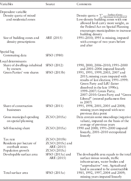
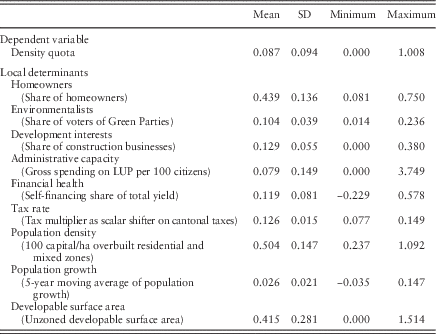
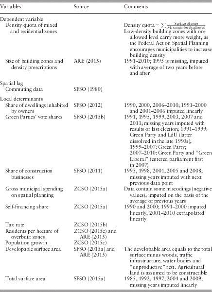
Municipal zoning is operationalised as a density quota of total residential and mixed unbuilt building zones. The quota calculates the surface area of each building zone and divides it by the number of levels allowed (more details on this computation can be found in Table A.1 in the Appendix). Low-density zones are given a greater weight in the index, as in these areas, residents consume more space relative to high-density zones. Unfortunately, differentiating the density quota with regard to its readiness for development is not possible, because the data are not reliable in this respect. Yet, the quota is a strong and direct indicator of a municipality’s spatial growth prospects. It also takes into account that expanding building zones can theoretically be substituted by increased density restrictions. It is important to note that once private land is declared a building zone, it cannot be reverted without buying it back from the owner or filing a lawsuit. Thus, a few instances of decreed reductions of building zone size are expected. In general, the distribution of the dependent variable is heavily skewed to the right (see Table A.2 in the Appendix); therefore, it is log transformed.
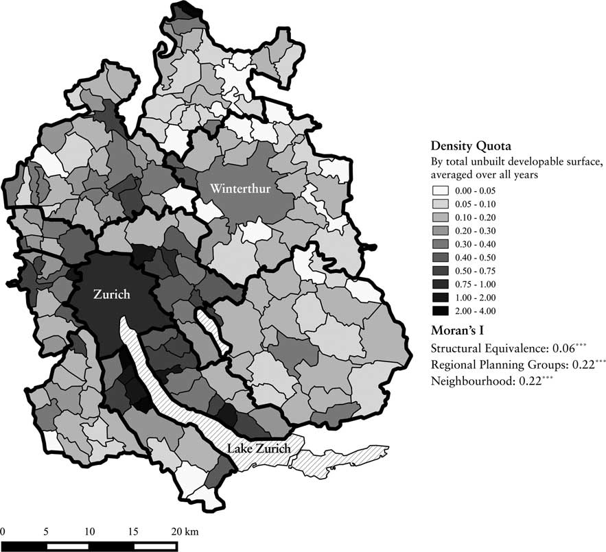
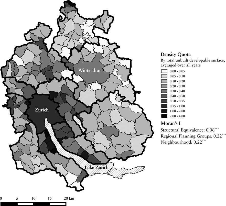
Figure 1 depicts the density quota on a map of the Canton of Zurich. For each municipality, the density quota is divided by the total unzoned developable area and averaged over all years. The thick lines indicate the 11 regional planning groups, which will be discussed in more detail below. Likewise, the Moran’s I, an indicator for spatial association, is explained in the Findings section. The density quota is noticeably high in municipalities surrounding the city centre of Zurich. In addition, in many municipalities located in exclusive areas near Lake Zurich (in the South Central region), a large share of the total developable surface area is zoned, presumably with low-density allowance.
Density quota and Moran’s I.
By the time the Federal Act on Spatial Planning was implemented in 1980, many Zurich municipalities had already zoned excess building land. As a consequence, substantial building zone expansion is rarely found in the data. Descriptive analyses reveal a distinct negative trend in the dependent variable, with a 40% average decrease in the density quota in the sample period. In most cases, the pace of building activities has outweighed the usually incremental expansions of building zones. This indicates that over the two decades under scrutiny, formerly excess building zones have been gradually overbuilt in most municipalities, and density restrictions have been tightened. Although the data do not allow for a clear differentiation between the two processes, the former is much more plausible.
Evidently, the prevalence of an abundant supply of building zones does not alter the incentives for local proponents of growth, thus continuing the driver of strategic interaction with regard to local land use planning. It is important to note, however, that for the case under scrutiny, the main subject of the hypothesised competition for mobile residents has not been the expansion of building zones, but rather the zoning decisions promoting and facilitating development in the existing zones. Thus, the following analysis focusses on competition in zoning decisions aimed at fostering construction activity and increasing the overall amenity of existing unbuilt zones, i.e., the actual reduction of existing unbuilt zones.
Spatial lag variable
The challenge for an empirical analysis of competitive interdependence in zoning decisions is to thoroughly operationalise which political entities are competing for the same residents, or, in other words, which are subject to growth control-induced migration. The literature on strategic interaction outlined above relies on contiguity and proximity. Thus, its empirical analyses are inherently limited to detecting strategic interactions in neighbouring, or very close, jurisdictions. Such operationalisations of interdependence based on neighbourhood and distance are very popular proxies. Besides their common application in the economic literature on strategic interaction (Brueckner 2003), they have also served as indicators for each of the three policy diffusion mechanisms. For this reason, Maggetti and Gilardi (Reference Maggetti and Gilardi2015) criticise the use of geography as a catchall indicator, as it is not able to discriminate between policy diffusion that takes the form of competition, learning or emulation.
Early studies on policy diffusion have also heavily relied on geography as the operationalisation of interdependence. In the recent past, however, scholars of policy diffusion have recognised and begun to acknowledge the fact that their units of interest are often linked beyond contiguity (Beck et al. Reference Beck, Gleditsch and Beardsley2006). Consequently, they have started to deliberately address the incoherence between the conception and measurement of interdependence (Maggetti and Gilardi Reference Maggetti and Gilardi2015; Neumayer and Plümper Reference Neumayer and Plümper2015).
With regard to the hypothesised competitive interdependence, a correlation between proximity and growth control externalities is not guaranteed. According to Ellickson (Reference Ellickson1977), growth controls encourage mobile residents to migrate to competing jurisdictions with similar comparative advantages on the regional housing market, both locational and with regard to public services. In reality, migrating residents evaluate potential locations based on time and money costs incurred by commuting, distance from relatives and friends, the price and availability of land or housing, the quality of public services and other locational factors (Tiebout Reference Tiebout1956; Helsley and Strange Reference Helsley and Strange1994). Thus, growth control-induced migration is hardly oriented towards neighbouring jurisdictions alone. Favourable destinations are most likely found within a specific radius surrounding the location of a person’s workplace, as defined by previous commuting costs. In metropolitan areas with a large number of small jurisdictions, such as the Canton of Zurich, alternative jurisdictions may very well outnumber the municipality’s immediate neighbours.
Moreover, on the supply side of growth controls, local government officials are aware of municipalities that have building land available and are offering similar public services, beyond their immediate geographical surroundings (Volden Reference Volden2006). Accordingly, an operationalisation based on proximity or contiguity constitutes an undue simplification. For this reason, I suggest an alternative operationalisation of competitive interdependence in a Tiebout-like economy – namely, one that is based on the correlation of out-commuting patterns.
Position similarity in the commuting network
Maggetti et al. (Reference Maggetti, Gilardi and Radaelli2013) promote social network analysis as an appropriate method to operationalise competitive policy interdependence. It allows for a thorough assessment of the connections between units and the structural properties of the network they constitute. According to Burt (Reference Burt1987), competitive pressure in a network of actors is a positive function of their similarities, and thus reflects how substitutable they are. As they share similar relations with other actors in the network, substitutable actors are prone to mimic each other’s actions (Strang and Soule Reference Strang and Soule1998). Accordingly, for analyses of interdependence of zoning decisions, the appropriate network needs to identify the municipalities that are the most similar, and thus substitutable for potential newcomers. In this study, competition for the same target group of mobile residents is assumed to be particularly strong among municipalities offering a similar combination of land and housing prices, distance to employers and provision of public services, amenities and other locational factors.
Rincke (Reference Rincke2010) suggests capturing this substitutability by means of outbound commuting flows. All households in a metropolitan area reveal their most preferred community (given their budget constraints) by having chosen it as their place of residence. If municipalities are thought of as specialising in order to serve households that are associated with a particular type of workplace, the out-commuting patterns of their residents may serve as an indicator of their substitutability for mobile residents. As a simplified example, if the residents of two municipalities, A and B, commute to the same municipalities, C and D, in equal or similar numbers, they can be thought of as close substitutes for a typical household that chose municipality A or B as a place of residence. This holds true for pairs of municipalities, irrespective of their geographical proximity. However, similar commuting patterns are more likely observed in pairs that are not situated in opposite corners of the study area. Thus, the similarity of out-commuting patterns of municipalities combines the determinants of housing demand with a geographical component.
Moreover, differentiating between the commuting patterns of people working in specific job categories allows for greater understanding of the substitutability of municipalities in a metropolitan area. In this way, disparities in housing preferences caused by budget constraints may be – at least partly – taken into consideration. This allows for differentiating between more- and less-exclusive places.
Computation of the connectivity matrices
For analyses of spatial interdependence, the theorised connection between the sources and recipients of spatial stimuli is captured in the form of so-called connectivity matrices W (Anselin Reference Anselin1988). For the following analysis, for each pair of municipalities, these matrices contain information regarding their proximity in the commuting network. The similarity of the actors and their positions in the networks are usually quantified by means of their structural equivalence (Henisz et al. Reference Henisz, Zelner and Guillén2005; Ingram et al. Reference Ingram, Robinson and Busch2005; Cao Reference Cao2010). It gauges the extent to which two actors share the same ties with other actors by correlating the amount of contact they have with all other actors in a network. Thus, the following analysis uses the structural equivalence of out-commuting flows as an indicator of the intensity of competition between each pair of municipalities in the sample.
The Swiss Census contains individual data on places of residence and work, and categorises jobs. For 20 distinct job categories, the structural equivalence is calculated with the Pearson correlation between two municipalities’ out-commuting flows to all other municipalities. In a second step, these correlations are weighted on the basis of their shares of total out-commuting workers working in the respective categories. Only the share of the workforce commuting to other municipalities is taken into account, as the rest contains no information regarding the position similarity in the commuting network. The original census variable differentiating between 88 groups of occupations was condensed to 20 categories on the basis of the similarity of the professions and their relative average salaries (see Table A.3 in the Appendix for a complete listing).
For each of these 20 job categories, the computation of Pearson correlations of out-commuting patterns results in a symmetric matrix. For each pair of municipalities (i.e. each element of a N×N matrix), these 20 correlations are weighted and summed up as follows:
 $$WCorr_{{i,\,j}} \,{\equals}\,\mathop{\sum}\limits_{x\,{\equals}\,1}^{20} {\mathop{\underbrace{{{{1{\minus}(Share_{{x,\,i}} \,{\minus}\,Share_{{x,\,j}} )} \over {20}}}}}\limits_{(1)}} {\times}\mathop{\underbrace{{{{Share_{{x,\,i}} \,{\plus}\,Share_{{x,\,j}} } \over 2}}}}\limits_{(2)}{\times}Corr_{{x,\,i,\,j}} $$
The weighting of the correlations for each job category x, i.e., Corr x,i,j , consists of two separate parts. The first division (1) calculates the difference in the shares of the workforces working in job category x for the pair of municipalities i and j. Accordingly, the more similar the shares of workers working in a specific job category, the more the similarity of the out-commuting patterns of workers in this category accounts for the total weighted correlation WCorr i,j . The second division (2) calculates the average shares of people working in job category x in the two municipalities i and j. Accordingly, the higher the shares of workers working in a specific job category as compared with all other categories, the more the similarity of the out-commuting patterns of workers in this category weights for the total correlation WCorr i,j . For example, if, in a pair of municipalities i and j, most people work in the financial sector, the correlation of the out-commuting pattern of people working in this job category carries more weight than the correlation in other job categories, because (1) a similar share of workers living in these municipalities work in the financial sector (that underlines the similarity of the municipalities with regard to their attractiveness for people working in this sector) and (2) a high share of workers work in the financial sector as compared with all other job categories (which underlines the relevance of the out-commuting pattern of workers working in this category).
This procedure results in a connectivity matrix that gauges the structural equivalence in the commuting network. The weighted correlations of out-commuting patterns are normalised to values between 0 and 1, and the final connectivity matrix is row-standardised.
Local determinants of zoning decisions
In addition to the zoning decisions in municipalities with similar out-commuting patterns, the density quota is regressed on the following local determinants of land use planning (see Table A.1 in the Appendix).
The share of dwellings inhabited by their owners measures the amount of political influence of the local homeowner interest group. The political strength of the environmentalist interest group is operationalised by the vote shares in the national parliamentary elections of those parties placing a specific emphasis on the protection of nature in their platforms. These include the Green Party, the LdU (Alliance of Independents) and the Green Liberal Party. The share of construction businesses of total local business premises is calculated to operationalise the strength of the local development interest group. As a potential shortcoming, however, the construction sector (and thus its lobbying) is most likely organised at a regional, not local, level. Furthermore, the gross government spending for land use planning per capita is included to measure the administrative capacity for planning. Higher total government spending enables local authorities to hire more professional planners and likewise to mitigate the impact of lobbying interest groups. Moreover, professional planners are assumed to require stricter growth controls, which lead to either a smaller share of developable land being zoned or zones of higher density on average, all else being equal. The administrative capacity variable is heavily right-skewed, as many municipalities only spend on spatial planning when their land use plan is revised. Therefore, it is included in the regression model as a square root.
Next, the financial health of municipalities is controlled with self-financing as a share of the total financial yield. According to the Statistical Office of the Canton of Zurich (Zurich Cantonal Statistical Office (ZCSO) 2015a), this variable captures the financial flexibility of a municipality. Wealthy municipalities have less need to promote development in order to broaden their tax bases or balance their budgets than less well-off municipalities, all else being equal. Furthermore, municipal tax rates are a crucial strategic variable in the competition for mobile residents and are also a determinant of Tiebout sorting (Schmidheiny Reference Schmidheiny2006; Schaltegger et al. Reference Schaltegger, Somogyi and Sturm2011). Municipal officials deliberately set the local tax rate as a location factor, at least to some extent. Thus, the strategic interaction of local tax policymaking is likely to be interrelated with the assumed interdependence of zoning decisions. However, empirically disentangling these processes is far from straightforward. Therefore, the municipal tax rate, which applies to both wealth and income taxation, is included as a scalar shift on the cantonal tax rate.
Empirical research has found that the intensification of population pressure, sprawling patterns of existing development and loss of amenities increase the local demand for growth controls (Brueckner 1995, Reference Brueckner1998; Richer Reference Richer1995; Schuetz Reference Schuetz2008; Hilber and Robert-Nicoud Reference Hilber and Robert-Nicoud2013). The population density of the built environment is calculated as the number of residents per hectare of overbuilt residential and mixed zones, in a log-transformed form. Population pressure is operationalised as the five-year moving average of population growth. This allows control for the amount of housing demand that a municipality needs to accommodate. The yet unzoned developable surface area is included as a control for how much of the municipal surface is left for zoning.
In order to control for time-invariant municipality characteristics that are not measurable directly but could influence zoning decisions, such as amenities or other geographic conditions, unit fixed effects are estimated.
Analysis
All of the existing studies of interdependence in local land use planning of which I am aware estimate models based on a single cross-section of data (Brueckner Reference Brueckner1998; Schone et al. Reference Schone, Koch and Baumont2013; Christafore and Leguizamon Reference Christafore and Leguizamon2015). Given that growth control decisions and their effects on development patterns and locational decisions are dynamic processes, analyses based on a single cross-section risk overlooking diffusion processes working over time (LeSage and Pace Reference LeSage and Pace2009). Therefore, the following analysis examines a panel of 171 municipalities from 1991 to 2010. The panel is analysed as a single, large N×T cross-section, with all T cross-sections stacked.
Thus, the estimation strategy of choice is a spatial autoregressive model of the following form (Anselin Reference Anselin1988):
 $$Y_{{t,i}} \,{\equals}\,\alpha _{i} \,{\plus}\,\rho WY_{{t,\,{\minus}i}} \,{\plus}\,\beta X_{{t,i}} \,{\plus}\,\tau Y_{{t{\minus}1,\,i}} {\plus}{\varepsilon}$$
The dependent variable Y is an NT×1 vector, and ρ the spatial autoregressive coefficient. W, the connectivity matrix reflecting the weighted structural equivalence in the commuter network, is a NT×NT matrix with N×N matrices along its block diagonal,Footnote 2 X is a NT×K matrix of K local determinants with coefficients β. A spatial Hausman test suggests a fixed effects model to be the appropriate specification (Millo and Piras Reference Millo and Piras2012). Thus, time-invariant predictors that could be of subordinate interest, such as potential effects of membership in a certain regional planning group, cannot be included in the model. Rather, all unobserved or omitted unit-specific heterogeneities are absorbed by the unit fixed effects α. The yearly density quota is likely to be correlated over time. Therefore, the lagged dependent variable (LDV) is included in the equation with coefficient τ (Franzese and Hays Reference Franzese and Hays2007; Wooldridge Reference Wooldridge2010).Footnote 3 Finally, ε depicts the NT×1 residual vector. Thus, ρ, gauging the interdependence with respect to position similarity in the commuter network, is the main coefficient of interest. A maximum likelihood estimation of spatial simultaneous autoregressive lag models allows for consistent and asymptotically efficient parameter estimates.
The connectivity matrix based on structural equivalence is contrasted with two alternative approaches to measuring competitive interdependence, which are common in the literature: joint membership in an institution and neighbourhood. The connectivity matrix for Model 1 (Structural Equivalence) contains the weighted and normalised structural equivalence of out-commuting patterns for all 171 municipalities. Model 2 (Regional Planning Group) is estimated with an alternative operationalisation of competition on the basis of joint membership in a regional planning institution. In these 11 regional planning groups, conflicts about future growth prospects of single municipalities are fought out, and regional development foci are set. In semiannual meetings, local planning officials discuss the latest zoning projects in the participant municipalities. Therefore, zoning decisions in the specific regional planning groups are likely to be correlated to some extent. Consequently, for Model 2, the scope of awareness for zoning decisions in other municipalities, and thus potential competitors, is presumably restricted to a subgroup of the municipalities in the same regional planning group, plus adjacent municipalities.Footnote 4 Accordingly, the W matrices for Model 2 contain dummies for these municipalities. Model 3 (Neighbourhood) includes a connectivity matrix based on neighbourhood.
Findings
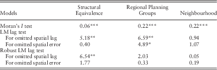
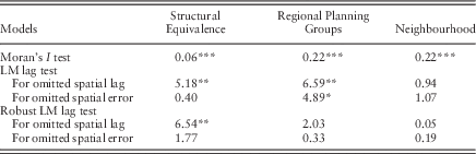
Table A.4 in the Appendix lists the simple spatial correlation of density quotas for the structural equivalence of out-commuting and the two other measures of interdependence tested as a comparison: the regional planning groups and neighbourhood. These Moran’s I values verify that the municipal density quotas in the Canton of Zurich are indeed subject to spatial association. Compared with the spatial correlation among members of the same regional planning groups and neighbouring municipalities, the correlation among municipalities with similar out-commuting patterns is rather low. Moran’s I is calculated on the basis of averages of the panel data, but without covariates.
As a next step, Lagrange multiplier (LM) tests that test for spatial association in the residuals of an ordinary least squares regression indicate whether a spatial lag or spatial error model specification is appropriate for the analysed panel. According to these, a spatial lag model is the appropriate specification for both Model 1 and Model 2 (Florax et al. Reference Florax, Folmer and Rey2003). For the connectivity matrix based on neighbourhood, the LM test results of both the normal and robust tests point to a rather weak spatial association, if controlled for local covariates.
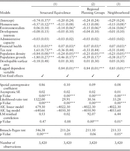
The results of the maximum likelihood estimations of the spatial autoregressive models are summarised in Table 1. In the first column (Model 1), the density quota is regressed on all local determinants, but no LDV. As the summary statistic shows below, the p-value for the spatial autoregressive coefficient and a likelihood ratio test indicate significant spatial dependence. In the first model, the share of homeowners has a negative effect on the density quota. In addition, financial health, tax rate, population density and population growth have a significant effect. In Model 1’s second column, including the LDV as a control for serial correlation, the share of voters for Green Parties has the expected negative effect, in lieu of the homeowners. The influence of the tax rate is also no longer significant.Footnote 5 The spatial autoregressive coefficient becomes much smaller, indicating that the temporal persistence in the density quota is misconceived as spatial interdependence if the LDV is excluded. Thus, controlling for the common trend in the density quotas by means of the LDV is of utmost importance. As the corresponding robustness checks reported in the online supplementary material show, however, the spatial interdependence resulting from the structural equivalence models is robust against both an estimation using instrumented spatial lags and an alternative estimation routine. Moreover, the likelihood ratio test and a comparison of the Akaike information criterions of the main models with and without spatial lag suggest that the spatial model represents a significant improvement as compared with a nonspatial specification. Yet, the results could partly be biased by common shocks, such as a change of policy at the cantonal level, for which only time-fixed effects could control effectively. In addition, according to the result of a spatial Breusch-Pagan test, heteroscedasticity is an issue (Breusch and Pagan Reference Breusch and Pagan1979).
Results
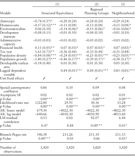
Note: SE in parentheses, *p<0.05, **p<0.01, ***p<0.001.
AIC=Akaike information criterion.
In comparison with the structural equivalence models, the spatial autoregressive coefficient is slightly lower but still highly significant for Model 2 in column three (of Table 1), including only municipalities in the same regional planning group and immediate neighbours. Again, the estimate of the LDV indicates significant serial correlation of density quotas. According to the Breusch-Pagan test and the LM test results, the residuals are heteroscedastic and still spatially correlated. For Model 3 in the fourth column, operationalising competition based on neighbourhood, the spatial autoregressive coefficient is even smaller. In general, Models 2 and 3 are very similar.Footnote 6
With regard to the quantity of interdependence, it has to be kept in mind that the dependent variable, and thus the spatial lags as well, are logarithms. Accordingly, the spatial autoregressive coefficient indicates the elasticity of the density quota with respect to the density quota in the other municipalities that have been taken into account. An average change in the density quotas in municipalities with similar out-commuting patterns results in an average change in the density quota of 0.10% (with equal sign) for the structural equivalence model (Model 1). For the regional planning group model (Model 2), an average change in the density quotas in municipalities in the same planning group results in a 0.09% change. For neighbouring municipalities (Model 3), the effect is 0.08%. Given the negative trend observed in the sample period, the average changes found most likely reflect a reduction in the size of the building zones due to construction activity. Hence, successful zoning decisions in one municipality provoke additional efforts to promote construction, and thus lead to a reduction in the size of the building zones in competing municipalities. These changes could, however, also be explained as either the result of a marginal enlargement of the building zones or zoning of building zones with lower density on average.
As one of two critical aspects that possibly limit the internal validity of these findings, the operationalisation of the theorised spatial interdependence could be subject to endogeneity of W and y despite the time lag in W. The development of transportation infrastructure and resulting commuter flows are slow and long-term processes. Thus, the evidence spatial interdependence found could be the result of similarly well-connected, rapidly growing municipalities reacting equally to comparable amounts of population pressure, and thus what is known as common exposure in the literature (Franzese and Hays 2003). However, the robustness checks with instrumented spatial lag confirm and strengthen the main finding of competitive spatial interdependence in communities with similar out-commuting patterns.
As a second concern, the interdependence of growth controls could be conditional on unit-level factors, such that only poor and less successful municipalities, or those with a lot of remaining unzoned land, compete for mobile residents. According to Neumayer and Plümper (Reference Neumayer and Plümper2012), spatial interdependence could be in many cases conditional on unit-level covariates. However, examining the potential interaction effects of local determinants with the spatial lag variable is beyond the scope of this analysis.
Conclusion
Zoning decisions in Zurich municipalities with similar out-commuting patterns are strategic complements, to some extent. According to the analyses of density quotas between 1991 and 2010, they are subject to spatial interdependence, even if local determinants are thoroughly controlled for. However, in most Zurich municipalities, relatively few actual zoning events took place during the sample period. Thus, the hypothesised competition has not been one of directly increasing or containing the zoned area, but of other policies aimed at attracting mobile residents. The empirical evidence for interdependence results from an increase in the propensity to make more of the existing building land ready for construction in order to elevate its attractiveness for mobile residents and building contractors.
In general, this is in line with the findings of Brueckner (Reference Brueckner1998), Schone et al. (Reference Schone, Koch and Baumont2013) and Christafore and Leguizamon (Reference Christafore and Leguizamon2015) for other growth controls. However, relying on operationalisations based on contiguity and inverse distance, their findings of a spatial association are prone to mistake other forms of interdependence for competition. The connectivity matrices calculated on the basis of the similarity of network positions in the commuter networks of different job categories represent a viable alternative to operationalise competitive interdependence in Tiebout-like economies [i.e. location-choice competition (Berry and Berry Reference Berry and Berry2014)] beyond contiguity. Discriminating between job categories, and thus the residential preferences of distinct income groups, allows for even more accurate modelling of the competition, which is an additional advantage.
Of course, this is also true for research on the diffusion of other local public policies. Thus, this article contributes to the policy diffusion literature in two ways: first, it analyses and offers insights into the competitive interdependence of local land use policymaking, a policy that has crucial implications for the future development and spatial organisation of metropolitan areas. Second, the proposed conceptualisation provides scholars of policy diffusion with a novel tool to refine the measurement of competitive interdependence of policymaking in local governments, particularly for analyses of location-choice competitions.
However, several factors influencing the locational decisions of mobile residents are not directly controlled for. Examples of these factors are real estate prices, accessibility to public services and natural amenities that are not included as such, but only proxied for by the previous decisions of residents working in the same place or by unit fixed effects. As reliable data are presumably scarce for most of these influencing factors, the structural equivalence of out-commuting patterns might be the most appropriate operationalisation to date.
Returning to the challenge of myopic local land use planning resulting in urban sprawl, the results of this analysis indicate that there is a need for action. If it is really a competition for mobile residents that fuels municipal planning officials’ ambitions to zone excess building land and foster construction activity, the benevolence and laxity of the cantonal approval processes for municipal zoning decisions need to be reconsidered. In addition, in metropolitan areas, the question of whether municipalities are the appropriate level of government to plan effective land use needs to be debated further. In the light of the adverse incentive structure and competitive interdependence found, transferring parts of the municipal responsibilities in the planning realm away from the local sphere of individual and business interests to a cantonal, or even metropolitan, administrative body could be beneficial. Thus, the efforts already made by setting up regional planning groups need to be reinforced, on an even larger scale than currently under way. Cooperative land use planning between neighbouring municipalities, which is often said to be a potential remedy for excessive growth ambitions in Swiss municipalities, might not do justice to the more regional phenomenon of municipalities competing for new residents.
Acknowledgements
The author gratefully acknowledges Tobias Schulz and Fabrizio Gilardi for their valuable comments. The author also thanks Jude Hays and Martin Steinwand for their helpful suggestions regarding the appropriate estimation strategy. Further, the author thanks the Swiss National Science Foundation for the financial support (grant number 100017_143440).
Financial Support
This study was funded by the Swiss National Science Foundation.
Supplementary material
To view supplementary material for this article, please visit https://doi.org/10.1017/S0143814X1600026X
Appendix
Data sources and details on imputations
Summary statistics
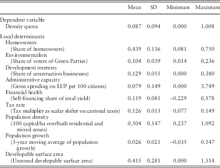
Job categories

Moran’s I and Lagrange multiplier (LM) tests