Introduction
Benjamin Leigh Smith carried out five private scientific expeditions to Svalbard and Zemlya Frantsa-Iosifa [Franz Josef Land] between 1871 and 1882. His interest in the Arctic was motivated by a desire to hunt Arctic wildlife, to make discoveries and to fill with his own funds a long gap in British government sponsored polar exploration. As Herbert Charles Chermside wrote after the 1873 expedition, it had been ‘nearly fifty years since attempts at reaching the highest latitudes [were] abandoned by British public enterprise and all such exploration [was being] carried on by foreign nations,’ especially Germany and Sweden (Chermside no date).
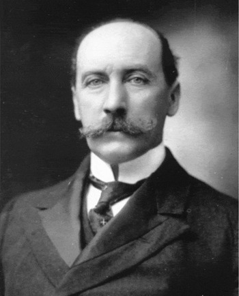
Chermside (1850–1929; Fig. 1) participated in the 1873 expedition, apparently his first major field experience, as surveyor, hunter, photographer and chronicler. An old boy of Eton, he had received the Pollock Prize as the top graduate of the Royal Military Academy at Woolwich in 1870 (Anon. 1875). Chermside's surveying and photographic skills would naturally have drawn Leigh Smith to him. But it is in his journal entries, written in a large, flowing hand, that he reveals himself as a humorous, adaptable companion, a good shot, and a man curious about the world around him. These same traits apparently served him well throughout his life. Thirty years later, as a colonial governor in Australia, he would be described as someone with a ‘readiness to share sacrifice, [an] approachable personality, wide range of interests, clear and forthright public speeches and [a] willingness to learn by travel. . .’ (Wilson Reference Wilson1979: 631–632).
Herbert Chermside later in life, possibly around the time that he was Governor of Queensland in Australia from 1902–1904. Credit: John Oxley Library, State Library of Queensland.

The results of Leigh Smith's first voyage to Svalbard in 1871 had appeared in two articles and two charts in Petermann's Geographische Mittheilungen the following year (Petermann Reference Petermann1872a, Reference Petermann1872b, Reference Petermann1872c, Reference Petermann1872d; Capelotti Reference Capelotti2006). The much more meager results of the 1872 expedition appeared in rather disjointed fashion in a popular account by John C. Wells (Wells Reference Wells1873; Capelotti Reference Capelotti2008). For his third voyage, Leigh Smith seems to have chosen Chermside not only for his abilities mentioned above but also so that he could combine the results of all three of Leigh Smith's expeditions into a comprehensive article that Chermside would later deliver before a meeting of the British Association for the Advancement of Science in August of 1874 (Chermside no date [Reference Chermside1874]; Rawlinson Reference Rawlinson1874: 5).
This British Association paper is divided into two sections, the first 25 pages consist of a recap of the three expeditions and the final forty pages are given over to a general discussion of the oceanographic conditions around Svalbard and its presumed value as a route to the North Pole. For the day-to-day details of the 1873 expedition, one must refer to Chermside's rather massive, three volume log kept on board Diana from 10 May to 26 September 1873 (Chermside Reference Chermside1873). All quotes from this unnumbered journal are from cited by their volume and entry date. Additional details come from the logbook of Samson, kept by its captain, William Walker, during its voyage that summer from Hull to Svalbard and back.
Background to the 1873 expedition to Svalbard
In the summer of 1871, Leigh Smith launched his first Arctic expedition, a geographical and oceanographical exploration of the north coast of Svalbard from the decks of an 85 ton ice-strengthened ketch named Samson. Captained by Erik Andreas Ulve (1833–1896), a Norwegian sealer and explorer, Samson took advantage of favorable ice conditions to define the northwest corner of Svalbard as far as a point later named after Leigh Smith. The five month expedition returned to England after gathering an extended series of data on seawater temperatures that made an important contribution to the study of deep ocean currents in the Arctic.
Leigh Smith had Samson fitted out for another voyage to the Arctic in 1872. The expedition left Hull on 13 May and mapped several craters on volcanic Jan Mayen Land before sailing for Svalbard, where ice conditions were considerably worse than a year earlier. A Royal Navy captain, John C. Wells, continued Leigh Smith's collecting of oceanographic data in the form of soundings, dredging, ocean temperature readings, and measurements of currents. When Samson was damaged and beached for repairs at Widjefjorden in September, Leigh Smith retreated to England, without sailing nearly as far to the north and east as during his first expedition.
His first two Arctic experiences, and in particular the difficult ice conditions of 1872, led Leigh Smith to reconsider the use of a single sailing vessel in the Arctic. Searching for a more durable vessel for his 1873 expedition, Leigh Smith chartered James Lamont's steamer Diana, which had been especially constructed in 1869 for Arctic cruising and hunting. That expedition had even left the ship's name behind in Dianabukta, an open bay on the southwest coast of Edgeøya where the vessel briefly anchored that summer (Norsk Polarinstitutt 1991: 111). The screw steam yacht was powered by 30 hp compound steam engines and its hull strengthened below the waterline with double layers of Australian bark and the bow clad with iron plates (The Geographical Journal 1913: 301–302; Chermside no date [Reference Chermside1874]: 6).
With Diana, Leigh Smith thought that he would for the first time possess the power to attempt to circumnavigate Svalbard and to survey Kong Karls Land. He was also committed to finding the whereabouts of the 1872 Swedish polar expedition led by Adolf Erik Nordenskiöld, an expedition he met at Fuglefjorden (Foul Bay) the previous summer. The addition of Samson as a reserve tender allowed Leigh Smith to carry a larger load of supplies, many of which would come to Nordenskiöld's aid early in the Arctic summer of 1873.
Departure and early days
On 10 May 1873, Chermside came on board Diana at Dundee, where he was given, as he writes, ‘a spacious chamber 5′6″ × 3′6″ which the steward was pleased to call my “state room”’ (Chermside Reference Chermside1873 I: 10 May 1873). Diana had a crew of seventeen, including a harpooner. Chermside was joined by fellow Etonian, 17 year old Richard Potter (1855–1947) and the naturalist and Reverend Alfred Edwin Eaton (1845–1929) as guests of Leigh Smith.
Another 13 persons sailed on board Samson, which had already departed from Hull on 30 April and arrived at Lerwick on 7 May. On 10 May, the reserve vessel began laboring her way through heavy seas to Svalbard.
The two vessels, outfitted with provisions for a year, planned to sail for Svalbard and rendezvous on 1 July at Kobbefjorden on the west coast of Danskøya. Replenished from the stores on Samson, Diana would then sail east along the north coast of Svalbard as far as Gilles Land, ‘should such exist’ (Chermside Reference Chermside1873 I: 10 May 1873). If the mythical Gilles Land did appear, they would follow its western coast, using the land as a barrier to any pack ice flowing from the east, and sail as far north as possible. The extra provisions were also crucial to Leigh Smith's other stated objective: to bring relief to Nordenskiöld's expedition.
Chermside was grateful to Leigh Smith for giving him the chance to take part ‘in an expedition in these regions, the exploration of which has always had a strange fascination in my mind’ (Chermside Reference Chermside1873 I: 10 May 1873). He was perhaps less grateful as Diana left the Firth of Tay and began to roll in the open sea and the soldier found himself absent from dinner for the first time in his life. Rather than fight a north wind, Diana put in to Lerwick in the Shetlands, where Chermside found himself ‘astonished at the absence of beggars’ (Chermside Reference Chermside1873 I: 12 May 1873), which is perhaps more a comment on 1873 London than on the Shetlands. Delayed in the islands for a week, Chermside met an old man who recalled to him the arrival of William Edward Parry's polar expedition in Lerwick in 1827. It was absence of the British government from the polar field since Parry that had provided much of the impetus for Leigh Smith's private efforts.
The expedition departed the Shetland Islands under steam on the 18 May, and Chermside was reintroduced to the sea. When the winds turned favorable, the ship's steam was run down and the sails hauled up. Just as this was completed, the winds died and the ship wallowed, making Chermside sick once again until steam could be got up again and the ship propelled northwards. Not until 20 May did they get a strong SSW wind that sped Diana along towards Svalbard.
Diana met the ice at 72°N, 1°6′W on 23 May, and just as it had with Leigh Smith two years earlier the new experience gave Chermside a chance to exercise his pen. ‘The ice floats about in white snow-covered detached blocks never much above 5’ from the surface & of every shape & form, the pieces being eaten into most fantastic shapes by the action of the water, the sides are a beautiful green & if only a bright sun were upon it, the effect would be lovely. Bump there we go as I write bang against a block, as far as the eye can see the sea is covered with these floating blocks. . . bump, bump. . . We are now in the long wished-for Polar regions. . .’ (Chermside Reference Chermside1873 I: 23 May 1873).
They met their first Arctic ships three days later. The first was the Swedish vessel Vega, which had been north hunting seals and was ‘evidently surprised at our flying the “blue ensign” & at once asks if we are an “expedition”’ (Chermside Reference Chermside1873 I: 26 May 1873). A few hours later, they met a Peterhead whaler called Active, which relayed the news that fast ice lay just to the north.
Five days later, a much longer information exchange took place when Diana came alongside another Peterhead whaler, the steam powered Eclipse. Eclipse's captain, David Gray (1827–1896), was a life long mariner and a friend and contemporary of Leigh Smith. Leigh Smith had provided Eclipse with deep-sea recording gear in 1872 and with it Gray had recorded nine ocean stations on a northeasterly line running from Greenland to Norway. Although an enthusiastic scientist, Gray was first and foremost a deep-ocean hunter. He shared with Leigh Smith the news that Eclipse was returning from its spring hunt with 250 tons of oil from a catch of two whales and 48,000 seals. So much oil was processed that they had been forced to throw some of the steamer's coal overboard to make room for more blubber.
Leigh Smith was carrying papers, letters and news for Gray, who had not been ashore since March. In the mist, Eclipse was rafted alongside Diana for a day as the officers and guests shared lunch on board Diana and then ‘a capital dinner . . . with a long conversation & numerous yarns’ (Chermside Reference Chermside1873 I: 31 May 1873). These included Gray explaining how he could use the remains of the blubber extraction process to drive the ship if his coal stocks became low. Using this method, he told his dinner guests that Eclipse had ‘steamed over 100 miles on the tail of a whale. . .’ (Chermside Reference Chermside1873 I: 31 May 1873). When Chermside mentioned that he was surprised at the absence of blubber smells on board Eclipse, Gray explained that it was cold enough that none of the seal or whale products putrefied at these latitudes. Gray then gave a tour of his cabinet of natural history curiosities, which included parasites collected from whales, narwhals and the stomachs of bearded seals.
By 6 June, impatient with the slow progress north, Leigh Smith ordered Diana east towards Prins Karls Forland in Svalbard. When the mountains and glaciers came into view the following day, Chermside had his first views of Svalbard and busied himself mixing chemicals for his photographic gear.
After Diana anchored near the glacier at the head of Kongsfjorden, Chermside and Potter rowed to a near shore lake that was full of birds. ‘I think I have never enjoyed an evening more,’ he wrote as he took in the pyramid-like summits of the Tre Kroner. ‘There was a glorious Arctic sun still high in the heavens, that even at midnight shone in all its pride above the Northern Hills, casting on their covering of the purest snow a sheen of golden light, so dazzling as to seem unearthly’ (Chermside Reference Chermside1873 I: 7 June 1873).
The next day, Potter and Chermside ascended a nearby mountain to find a cairn already there. When they dismantled it, they discovered notes in French and Swedish proclaiming that the Swedes had reached the spot in 1861. In the meantime, the much slower Samson had on 22 May fallen in with the ice around 70° N, and the crew began working north along the edge of the ice, sealing as they went. They sighted Prins Karls Forland on 20 June and the next day, as Captain Walker wrote in his log, ‘came to anchor in Magdalena Bay in 13 fathoms above the small island at the head of the bay; caught 3 seahorses’ (Walker Reference Walker1873: 21 May 1873).
The relief of Nordenskiöld
Departing Kongsfjorden on 9 June, Diana rounded Hakluyt's Headland in the evening of 10 June. After some exploring in this area and leaving word for Samson in Kobbefjorden, they met a Norwegian fishing smack early in the morning of 13 June. The captain, whom Chermside called ‘Charlie the Norseman’ told Leigh Smith that Nordenskiöld and the rest of the Swedes were lying beset and starving in Mosselbukta.
‘This is news indeed,’ wrote Chermside, and Leigh Smith wasted no time in ordering full speed to the rescue (Chermside Reference Chermside1873 II: 13 June 1873). Charlie the Norseman was rowed smartly back to his smack with a bottle of rum and Leigh Smith's compliments.
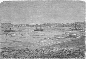
Diana reached Mosselbukta, which Chermside described as a mere ‘unprotected indulation [sic] in the coast on the E side of Wiide Bay [Wijdefjorden]’ in four hours (Chermside no date [Reference Chermside1874]: 8; Fig. 2). There, the three Swedish vessels, the 200 ton, 108 ft iron steamship Polhem along with the steamer Onkel Adam and the brig Gladan, were frozen into the northeast corner of the bay, in ice that Chermside estimated at three to seven feet thick and with more than three miles separating the ships from open ocean.
Nordenskiöld's three ships lying beset in Mosselbukta (from Kjellman Reference Nordenskiöld1875).

All the flags on Diana were run up. The ladder was put over forward but the ‘hardy Swedish sailors’ ignored it, swinging themselves on board to be greeted with tinned meat and schnapps. ‘We smoke & chat & drink each other's health & talk & have quite a spirited party’ (Chermside Reference Chermside1873 II: 13 June 1873).
Leigh Smith had met Adolf Erik Nordenskiöld and 22 other members of his Swedish polar expedition on board Polhem the previous August when Samson anchored in Fuglefjorden in late August. They were of similar ages (Leigh Smith was 44 and the Swede was 39) and shared social status, education and wealth. They had exchanged visits on their respective vessels and formed a bond of shared experience and ambition in their Arctic research. If there was a difference between them it was that Nordenskiöld was willing to leave his ship and try to reach the pole over the ice, whereas Leigh Smith was the classic gentleman-adventurer who would go ashore for a long hike in search of his fill of game birds but seems never to have seriously contemplated a polar sledge expedition.
Nordenskiöld planned to sail to Sjuøyane and to construct a base camp on Parryøya with several prefabricated structures. From this point, Nordenskiöld had hoped to lead an expedition to the pole in April 1873, using boats and sledges pulled by reindeer driven by four Lapps. When the two explorers parted from one another on 30 August 1872, Leigh Smith promised Nordenskiöld that he would return to Svalbard early the following summer and call in on the Swede for news of his polar expedition.
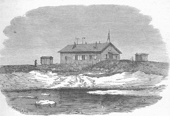
Soon thereafter, Nordenskiöld sailed north and discovered that he was not able to penetrate further than Mosselbukta. Worse, all three Swedish ships were caught by surprise and frozen in for the winter. The huts and observatories meant for Parryøya were instead erected at Mosselbukta and Nordenskiöld was forced to divide rations amongst 67 people from three ships over a Svalbard winter (Fig. 3). The following April, the winter hardships notwithstanding, Nordenskiöld made an attempt on the pole with three teams, several sledges, boats and a single reindeer. The conditions were extremely difficult, with broken seas and fog. One crew member who left in search of driftwood was not seen again.
Nordenskiöld's winter quarters at Mosselbukta (from Kjellman Reference Nordenskiöld1875).

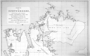
The expedition managed to reach Sjuøyane where they saw the hopelessness of attempting to cross the vast fields of broken ice to the north. Instead of returning directly, Nordenskiöld retreated via Nordaustlandet in order to explore that area, so when Leigh Smith arrived off Mosselbukta he was still away (Fig. 4).
Nordenskiöld's 1875 chart of Svalbard, showing his route from Sjuøyane southwestwards to Nordauslandet and back to Mosselbukta (from Kjellman Reference Kjellman1875). The map also shows the continued fascination with the mythical ‘Giles Land’ thought to exist somewhere to the east-southeast of Svalbard.

By evening on the 13 June, Leigh Smith had his crew members moving provisions by sledge from the British to the Swedish ships. It was, Chermside wrote, ‘a great triumph for the judgment of B.L. as regards ice, current, winds, etc., as in his letter to the Times in the winter, & ever since, in spite of many contrary statements, he had predicted that they would be lying there. This he takes in his usual quiet way’ (Chermside Reference Chermside1873 II: 13 June 1873).
From the Oxford and Cambridge Club the previous November, Leigh Smith had written a letter to The Times in which he spelled out his concerns over Nordenskiöld's fate. He thought, correctly, that the Swedish expedition had put in to some safe harbour, unloaded their cargo but, before the two supply ships had been able to get away, they had been locked in the ice. He felt that the Swedes would survive the winter on the strength of their supplies and their ability to live off the land. In a moment of both expression and introspection, Leigh Smith wrote of the last time he saw the Swedish fleet at Fuglefjorden, ‘rosy with the ray of the evening and the morning sun’ (The Times (London), 19 November 1872). As Samson cleared the fjord on its way southwards, Leigh Smith wrote that he felt ‘something like the shame of desertion’ (The Times (London), 19 November 1872) and promised that he would search for Nordenskiöld when he went north again in the spring. These are clearly the words of someone who saw Nordenskiöld as a friend and colleague rather than a polar competitor.
The survival of most of Nordenskiöld's crew (another died of scurvy) was in sharp contrast to the deaths by starvation and exposure of nineteen Norwegian whalers trapped in Svalbard by the severe ice conditions the previous summer. By mid-September, 1872, six whaling vessels had been frozen in near Velkomstpynten. Seventeen whalers managed to escape in small boats to a hut at Isfjord but, once there, all died over the winter. Two other whalers refused to leave their uninsured ship and were later found dead in a small boat, their ship having been crushed (The New York Times, 3 August 1873).
Yet, despite their successful overwintering, Nordenskiöld's expedition was in a difficult situation by early June, 1873. The expedition's chief scientist, the physicist August Wijkander, noted that the first vessel to reach the Swedes arrived on 7 June, followed the next day by two fishing vessels from Tromsø. They delivered letters and newspapers and a little butter and flour. It was apparently this partial relief on the part of Nordenskiöld's agent in Tromsø that convinced the Swedish government that a large relief ship from Sweden was not required.
They could not have been more incorrect. Wijkander appealed without success to the fishing vessels to return to the mainland for supplies, but the Norwegian skippers were reluctant to abandon their seasonal work before it had even begun. ‘By this time all but one of the people aboard Onkel Adam had come down with scurvy, and half of the crew of Gladan, too. Even if all of the ice had magically disappeared from Mossel Bay . . . there just were not enough [healthy] men available to sail them home” (Kish Reference Kish1973: 111–112).
Just as the Swedes began to sink into renewed despair at the worsening situation, Diana along with Samson appeared just beyond the ice in Mosselbukta. Wijkander wrote of the almost miraculous appearance of “an English gentleman, Mr. Leigh Smith [who] offered the expedition with great generosity . . . lime juice, tobacco, rum, fresh potatoes, and preserves for more than two weeks for all men, which we received with great gratitude’ (Wijkander Reference Wijkander1873).
Lieutenant P.M. von Krusenstjerna, commander of Gladan, observed that the fresh provisions allowed the men suffering from scurvy to recover in little more than a week and so ‘are able to join in the severe work of sawing a passage through the ice in order to deliver us out of our ice-prison’ (Krusenstjerna Reference Krusenstjerna1873). A member of the Polhem crew went further, writing on 19 June that all of ‘the sick have rapidly improved and that already in six days. Such a generous and at the same time beneficent gift deserves indeed to be made known’ (Anon. 1873). The expedition's medical doctor, A. Envall, wrote in a report to the Swedish Board of Health that they would ‘not have got off with less than one or more deaths’ if Leigh Smith had not arrived when he did (Leslie Reference Leslie1879: 406).
As Nordenskiöld's Lapps, ‘in their curious hats & long blue frocks . . . and bright leggings, smoking their pipes,’ looked on, Chermside acted as quartermaster as provisions were off-loaded from Diana for the Swedish survivors. ‘Half a ton of beef, 40 tins of cabbage, 20 tins of salmon, 1 case of sherry, 1 case of brandy, 10 tins of carrots, 2 cases of lime juice, 59 lbs of tobacco, 5 bags of potatoes & 10 gallons of concentrated rum’ (Chermside Reference Chermside1873 II: 13 June 1873). Along with Eaton, Leigh Smith took lunch with the Swedes, going over their scientific results for the winter. Chermside, for his part, had perfected his sly style of revealing the quirks of character of his compatriots: ‘Eaton was much pleased with their collection of sea-weeds’ (Chermside Reference Chermside1873/2: June 14). Eaton had earlier in the year written to Leigh Smith's sister Barbara Bodichon, apparently at her request, that he had compiled lists of all of Svalbard's flora as well as ‘of the Seals and Whales, Birds and Shells’ so that in between his collecting forays he would be able to see at a glance where he had gaps in his efforts and strive to fill them in (Eaton Reference Eaton1873).
Chermside visited the Swedes’ small village of science huts and saw the three ships locked in ice about a quarter mile from shore. The Onkel Adam was in the centre, with Polhem to the left and Gladan to the right. He thought that they could not have selected a worse place to be stranded, as between the ships and the open sea was a screen of grounded ice and several large hummocks. From his few weeks of experience with ice conditions around Svalbard, he thought it unlikely that the rotting floe would keep the three vessels trapped for much more than another month.
Diana remained at the edge of the floe near Mosselbukta until the morning of 15 June, when steam was raised and the ship moved off toward Sjuøyane. Leigh Smith hoped to catch up with Nordenskiöld there, for if the Swede had managed to reach the pole he was scheduled to return to Parryøya on 23 June and would almost certainly welcome, if not require, some assistance. When ice blocked Diana's approach to Parryøya, ice anchors were deployed to moor the ship to a floe halfway between Parryøya and Waldenøya. Leigh Smith, along with Chermside and Captain Fairweather, Diana's skipper, rowed the three miles to Waldenøya and climbed to its highest point to gain a view to the north.
From this perch, they could see that all of the islands off the northwest coast of Svalbard were linked by ice. Ice blocked the ways to the north and east as well. The three regained the ship and began a long exploration along the ice edge, gliding through still, clear water and making occasional soundings as they went. ‘A deep sea sounding [on Sunday, 22 June 1873] of 800 fathoms gave no bottom & we got plenty of exercise hauling in the line’ (Chermside Reference Chermside1873 II: 22 June 1873). They again returned to Sjuøyane, as ‘the owner is very anxious to get to Parry's Island to see if there is news or trace of the Swedes’ (Chermside Reference Chermside1873 II: 28 June 1873).
Once again they anchored to a floe and this time Leigh Smith, the captain, and two crew members trudged across the ice toward Nelsonøya in search of Nordenskiöld. Chermside and Eaton rowed back to Waldenøya to collect some lichen. There Chermside found an old coffin filled with stones and a bone or two. They had brought miniature caskets of their own, as Chermside thought of them, for Eaton's botanical collecting. They ascended to the highest point of the island, collecting lichens, flowers and grasses along the way, and then wrote the names of their prizes in Latin ‘with care and precision, on the lids of the nice little wooden coffins prepared for any rarity vain enough to bloom & pining for sepulchre in a museum, by the indefatigable Eaton’ (Chermside Reference Chermside1873 II: 28 June 1873). They reached Diana just as Leigh Smith returned to announce that he had found no sign of Nordenskiöld on Nelsonøya.
On 29 June they made a journey to Tavleøya and, climbing to its height, stood for a long time gazing north. Chermside seemed to realise that he would very likely never again set foot on land so far north, so he looked intently ‘over the ice towards the mystic pole, that defies approach.’ When it was time to return to the ship, ‘it is almost with a feeling of awe that one turns away from the outmost (or inmost) threshold of the dread unapproachable tract of frozen ocean. . .’ As they reached the shore, lit their pipes and waited for the launch, the euphoric feeling began to recede until they were once again ‘ordinary’ (Chermside Reference Chermside1873 II: 29 June 1873).
Exploring Hinpolenstretet and Wijdefjorden
Having arrived at Magdalenafjord on 20 June, Captain Walker of Samson had sent one of his small boats north to Danskøya and the planned rendezvous point at Kobbefjorden. It returned the following day with the news that they had reached Kobbefjorden and brought back ‘letters from the Diana and found a [separate] letter, on a small island near Kobbe Bay [Kobbefjorden], from the Danish expedition dated 11th Oct. 1872’ (Walker Reference Walker1873).
On 1 July Samson got underway toward the Sjuøyane and they soon ran into Diana, which was manoeuvering south. The steamship took Samson in tow and brought her into Sorgfjorden the same evening. As coal, stores and fresh water were transferred to Diana over the next three days, Chermside climbed to the top of what he called Parry's Hill (Heclahuken), where two years earlier Leigh Smith had found a flag staff left by Parry in 1827. The staff was now gone, and Chermside relates a rather extraordinary tale of its disappearance from the 486 m high summit. He writes of a group of Norwegians trapped at Sorgfjorden, presumably during the catastrophic freeze-up the previous fall, who ‘nipped it as a mast to a piece of drift ice + proceeded on their way’ (Chermside Reference Chermside1873 II: 2 July 1873).
On 6 July Leigh Smith was on board Samson to talk with Captain Walker and review his charts prior to making his main push north and east. Once the transfer of supplies between Samson and Diana was completed, a few of the men went ashore to ‘collect whalebones, ancient + very bleached’ (Chermside Reference Chermside1873 II: 6 July 1873).
Chermside in the meantime hiked to Mosselbukta, presumably alongside the low-lying streams and swampy ground that run up from Sorgfjorden and then down to Mossellaguna. There he found Nordenskiöld's huts barred, the windows boarded and no smoke rising from the chimneys. The Swedes at last had made their escape.
Nordenskiöld himself had journeyed south over the ice from Phippsøya to Kapp Platen. Stopped east of Kapp Platen by open water, Nordenskiöld sought to cross Nordaustlandet to its southeasternmost point at Kapp Mohn. Discovering an impenetrable landscape of ‘ice canals,’ Nordenskiöld and Palander studied the area before giving up any hope of traveling further south.
The impassable glacial landscape forced Nordenskiöld west, toward Wahlenbergfjorden, which he and his men reached in mid-June just as Leigh Smith was relieving the Swedish base camp at Mosselbukta. Nordenskiöld and his party finally returned to Mosselbukta on 23 June, less than a week after Leigh Smith had departed. No other expedition of Nordenskiöld's, writes George Kish, was ‘as beset by trials and bad luck as the expedition of 1872–1873’ (Kish Reference Kish1968). Only the timely arrival of Leigh Smith had prevented the Swedish expedition from tipping into a complete Arctic catastrophe.
Chermside learned all this when he returned to Sorgfjorden and saw Polhem anchored alongside Diana. Prior to a brief exploration northwards before his return to Sweden, Nordenskiöld had come to thank Leigh Smith. The other two Swedish vessels had made their way south on 30 June, quickly departing the scene as soon as the ice had moved out of Mosselbukta. Eaton wrote a hurried note home to his father, the M.P. Thomas Bayley Potter, saying that the Polhem had come in the night before and was leaving that day. ‘I must finish this letter,’ he concluded, ‘as we are just going on board the Polhem to say goodby.’ The contrast between the ordeal the Swedes had just endured and Leigh Smith's cruise was apparent, as Eaton finished with a cheery postscript saying that he had ‘never enjoyed anything as much as this trip, and don't feel the cold a bit. It is warmer here than it has ever been, the temperature being 49 deg. We have plenty of sport with the birds, eider ducks, etc., and find them all capital eating. . .’ (Eaton Reference Eaton1873).
The meeting between Leigh Smith and Nordenskiöld must have been brief indeed, or perhaps private, for Chermside makes no mention of it in his otherwise expansive journal. Both men were serious in their respective intent to explore the north, and the brief summer was already advanced. It was perhaps at this meeting that Nordenskiöld mentioned the possibility that the north cape of Svalbard was in fact an island and suggested naming it for the man who saved him, while the ever-humble Leigh Smith deferred the honour to his young aide-de-camp Chermside.
On July 7, Diana moved out of Sorgfjorden and down Hinlopenstretet to a group of islets called Fosterøyane that Nordenskiöld had explored in 1861 (Norsk Polarinstitutt 1991: 140). There Leigh Smith's expedition was itself beset by ice that stretched all the way across the strait from Kapp Fanshawe to Selanderneset. Retreating into Lomfjorden, Chermside found a ‘vertical pillar of flat stones covered with inscriptions in Norwegian’ (Chermside Reference Chermside1873 II: 11 July 1873). Fishing smacks with ill or injured crew would call on Diana for a chance to be treated by Eaton, who passed for the only doctor north of Tromsø and served as a kind of replacement for Envall, who had performed much the same duty during the Swedish expedition's stay in Svalbard.
On 14 July they were hailed by Norwegian skipper Frederick (Fritz) Christian Mack (1837–1876), of whom in the volume The place names of Svalbard is written ‘several important geographical discoveries in the Arctic are due (Norsk Polarinstitutt 1991: 277). ‘Like all these Norwegian skippers that I have met,’ Chermside wrote, ‘he is a well-informed superior class of man. . .’ (Chermside Reference Chermside1873 II: 14 July 1873). Mack had also been sent by Nordenskiöld's agent in Tromsø with supplies for the beset expedition, but had arrived after the relief from Leigh Smith. (Three years later, Mack wrote a plaintive letter to Leigh Smith complaining that he had been swindled by two putative foreign polar expeditions, had been without work for a year and a half, and was at the end of his tether (Mack 1876)). He died a few months later.
The next day, Diana escaped Hinlopenstretet and anchored back in Mosselbukta only a short distance from the Swedish camp. ‘How different on a calm sunny summer evening like this it looks from the dreary icebound haven of 4 or 5 weeks ago’ (Chermside Reference Chermside1873 II: 15 July 1873). With the way north blocked by ice pressing on the north coast, Diana manoeuvered down Widjefjorden where Chermside and Potter went ashore to do some surveying while Leigh Smith initiated his dredging and collecting operations. Samson in the meantime had caught up with Diana, and for several days the two vessels, along with a collection of Norwegian fishing smacks, anchored in Lomfjorden to await favorable conditions.
Leaving its escort on 14 July Diana passed beyond Kapp Petermann and anchored near a small island in Austfjorden that Leigh Smith named after Diana. On the newly-christened ‘Diana Island’ they went on a deer hunt, returning with no less than sixty-eight deer, two or three seals, and seven white-fronted geese, which Chermside described as a ‘new species to Spitsbergen’ (Chermside Reference Chermside1873 II: 21 July 1873). Chermside noted that the hunting was a very trying experience, as the ‘excitable sailors are not trained gillies, will not keep line, do not know when to stand, when to show, when to squat, or act in concert at a distance. . .’ (Chermside Reference Chermside1873 II: 21 July 1873).
The expedition remained anchored near Diana Island for several days, surveying the island and a nearby shoal, while the crew performed the chores of painting the vessel, flensing, salting skins, and preparing heads for mounting. On 25 July, they continued dredging operations and the following day began a running survey as Diana retreated back toward the mouth of the fjord in another attempt to get north.
Dredging operations and a visit to Moffen
On 27 July, the expedition sighted ice-covered Lågøya and did their best to avoid the seas around it, which Chermside noted were foul with ‘black wicked rocks & reef’ (Chermside Reference Chermside1873 II: 27 July 1873). The following day they took up dredging in 120 fathoms with a whale line and a heavy iron dredge weighing one cwt.
Chermside described several other aspects to this dredging operation. First, a ‘swab’ to gather up starfish and seaweed, echinoderms and stones from the bottom was fashioned from a ‘long broom of oakum used to clean the decks.’ To this was added a small tin to form a scoop to capture stones or gravel, along with a small hoop net and a sounding lead to gauge the character of the bottom. Deep-sea thermometers were attached at intervals of fifty fathoms. Deploying the dredge many times in a single day was impossible, as it was so heavy it required all hands to haul it out of the depths. The device likewise took a toll on the specimens collected. As Chermside wrote, ‘any animals unlucky enough to be caught in this are of little value, since they have been pounded to fragments or reduced to become amateur jellyfish. . .’ (Chermside Reference Chermside1873 II: 28 July 1873). Hemmed in by ice on 29 July, the crew nevertheless managed to sound and dredge with their ‘swab’ when possible and retrieve what Chermside described as ‘some fine specimens of coral’ (Chermside Reference Chermside1873 II: 29 July 1873).
Diana pushed through the ice and into Lomfjorden on 30 July, there to be met by four Norwegian fishing smacks. Increasingly unable to manoeuver, Leigh Smith made for Heclahamna to gain an elevated view of the ice conditions. Still station keeping after several days, Chermside wrote that ‘Macawber-like, we wait for something to turn up’ (Chermside Reference Chermside1873 II: 4 August 1873). On 5 August, Diana made its way offshore to Moffen Island, where a year earlier Leigh Smith and his team had discovered an enormous whale skeleton buried in the shingle and covered with inscriptions and ship's names carved into the bone by earlier visits by hunting expeditions. Chermside described Moffen as a low-lying mass of shingle just a few feet above sea level, with a scattering of granite boulders apparently carried onto the island by the movement of ice grounding on the shoal ground. One group began walking around the lagoon in one direction while a second group walked the opposite way. An hour and a half later the two parties completed a circuit that Chermside estimated to be about seven miles and met ‘at opposite points of a large natural bay or harbor which occupies the greater part of the interior and which had still a great deal of land ice in it.’
The entrance to the harbour lay on the northwest corner of the island, not along the north as shown on their charts. They had been looking for walrus but found only carcasses of walrus killed along the inner edge of the lagoon. ‘We also saw which was far more interesting the bone-covered sites of what at one time must have been glorious engagements with large numbers of sea-horse. There were three of the sites with immense quantities of bones of the animals evidently all killed at one time & the layers of these was over an acre in extent & I am rather sorry I did not count the number of skulls’ (Chermside Reference Chermside1873 II: 5 August 1873). If Leigh Smith took this chance to seek out the skeleton he had found the previous year Chermside does not mention it. He does mention a painting hanging in the dining room of the Admiralty that depicted Moffen Island and an attack on a large number of walrus by men of the Phipps expedition of 1773, so it seems clear that the island's connections to British polar history were the subject of discussion amongst the exploring parties.
After two days around Moffen, Diana returned to Lågøya and then continued southeastwards along Hinlopenstretet, arriving at Augustabukta on 10 August. Here Chermside does mention a phenomenon associated with the whale skeleton from Moffen, which had apparently died naturally and been raised by isostatic uplift. The shingle beaches Augustabukta showed the remains of whales ‘killed perhaps 100 years ago, the dates indeed have been in some cases determined, then the skeletons too heavy to drag above it must have lain in the water & now you find skeletons almost complete at 6, 8 & 10 feet above the sea level’ (Chermside Reference Chermside1873 II: 10 August 1873). Chermside does not describe the skeletons in any detail, nor how he arrived at a relative death date, so it is not possible to know if the whales died naturally or showed evidence of butchering, but his assumption that the skeletons were left in shallow water being too heavy to be dragged makes it clear that he believes the whales were killed by humans. Such evidence at the remote Augustabukta could mean that, absent a shore tryworks, the whales were pursued into shallow water by the occasional visit of a pelagic hunting expedition or an expedition operating away from the established whaling stations on the west coast of Spitsbergen. There they could have been flensed alongside a ship, the blubber boiled down on board and the largely intact carcasses left to rot, as opposed to being set adrift as in deep-harbor or open-ocean whaling (see for example the description of harbour whaling by British whalers in the 1660s by Conway Reference Conway1906: 205).
Chermside's estimate of a death date of 100 years earlier seems to be confirmed by later geological research. Using an uplift rate of approximately 1 cm per year, posited for a Russian hunting hut in Nordaustlandet (Olsson and Blake Reference Olsson and Weston1961–1962: 16), Chermside's whale skeletons, resting at approximately 2 to 3 m (6, 8 and 10 ft) above sea level in 1873, would have died or been killed between 182–304 years earlier, or at some point between the years 1569–1691, an acceptable range that brackets the discovery and shore-based exploitation of right whales around Svalbard and its transition into pelagic whaling. The greater the annual uplift, such as the 2.99 cm per year reported by Jahn (Reference Jahn1959: 157) from Hornsund in southern Svalbard, the more recent the death of the whales. Jahn's Hornsund data applied to Augustabukta would produce a death range of 1764–1807, with a median year of 1786, and very close to Chermside's supposition.
Of course, the beach matrix itself is not an absolute dating of the whale since, as Blake (Reference Blake1961: 137) points out, such whales did not necessarily die right at the shore. Blake's radiocarbon dating of whalebone fragments found at an elevation of 7.8 m asl (25.59 ft) produced dates of more than 6,000 BP (Blake Reference Blake1961: 141). A host of other factors, from storm surge to human agency, could also factor into the timing, location, and elevation of the remains. The only certainties are that the higher the whale's elevation and/or the slower the rate of uplift, the more likely such skeletons predate human activity on Svalbard. The low elevation of Chermside's whale skeletons at Augustabukta, like the palimpsest whale found at Moffen, both suggest human agency. Perhaps it was while contemplating these maritime mysteries that Leigh Smith repeated his comment about Svalbard to Chermside: ‘[T]he owner always says it is like Switzerland with the sea’ (Chermside Reference Chermside1873 II: 10 August 1873).
Returning to familiar waters east of Tumlingodden, near where Leigh Smith had circumnavigated Wilhelmøya in 1871, Chermside recorded a humorous scene when the entire watch gathered around the heavy dredge for a deep-sea sounding in heavy ice, only to find that the water was but 34 m deep. Diana continued around the southern edge of Nordaustlandet to Vibebukta, which the crew also dredged. Chermside notes that Leigh Smith wanted to explore ‘Wiches Land’ [Kong Karls Land], just visible across the pack, but the expedition was stopped by ice near Kapp Mohn. They returned northwestwards along Hinlopenstretet, emerging from the strait on 23 August with hopes of reaching the Sjuøyane.
To Chermsideøya and a furthest north for the summer
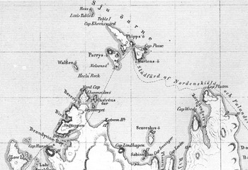
With ice still fast to the north, Leigh Smith led the expedition east towards Kapp Platen. There Diana anchored in shallow water in an ice-covered ‘Parry's “Beverly Bay,”’ which Leigh Smith, perhaps with an earlier inference from Nordenskiöld, correctly believed to be a channel, or sound, and the land north of the channel to be an island (Chermside Reference Chermside1873 III: 29 August 1873). Nordenskiöld (see Kjellman Reference Kjellman1875; Fig. 5) in his chart of Svalbard named this 14 km2 island after Chermside, and it is now known as Chermsideøya (Norsk Polarinstitutt 1991: 96). This is apparently the only new place name added to the nomenclature of Svalbard during the 1873 expedition, and that it was named for the young expedition member speaks volumes for the impression he made upon Leigh Smith, and perhaps on Nordenskiöld as well.
Detail from Nordenskiöld's 1875 chart of Svalbard, showing the area of northern Svalbard bounded by Rossøya, Lågøya, and Kapp Platen (from Kjellman Reference Kjellman1875). It was in this area that Leigh Smith spent much of his 1873 expedition in search of Nordenskiöld, and where he decided that Beverly Bay was in fact a sound or channel separating Nordaustlandet from the island to the north. This shows that the island north of Nordaustlandet had already by 1875 been named ‘Chermsides ö’ for the then 23 year old Herbert Chermside (from Kjellman Reference Kjellman1875).

With the ice under heavy pressure, the crew spent its time moving from one anchorage to another. In his unpublished account, Chermside provides an extensive discussion of the ice-breaking methods employed by the crew of Diana. Since leaving the southeastern end of Hinlopenstretet, the vessel had made only slow progress in the heavy ice. On 28 July, with the pressure of the ice lessening, the crew, as Chermside related, ‘set to work in earnest to extricate ourselves from the pack, as further progress E seemed impossible and the pack was more or less cemented together by early and very sharp frosts’ (Chermside no date [Reference Chermside1874]: 19). On 8 August, Diana had managed 15 miles progress in nine hours through heavy pack, but as Chermside wrote, this required that the ice have some ‘play’. Now, with three miles of heavy ice separating the ship from sailing ice, the steam engines were run up and the crew warped the ship from its temporary ice dock. Several of the crew was put onto the ice armed with boathooks. Once the vessel had some maneuvering space and the likeliest spot for the ice to crack was spied from the deck, the ship was rammed into that spot. Loose ice was then pushed aside by the men with the boathooks, or they hopped onto the broken ice and punted the ice out of the path of the ship. While this was carried out, Diana was backed to the farthest corner of the cleared area, sometimes as much as 200 m. ‘Then she comes ahead full steam and jumping right on to the ice, succeeds in cracking it. At it she comes again and again and several large piles are by this time smashed. On to these men jump with drills and boring holes. Ice hooks and warps are made fast from the ship and they are towed out of the way, the boathook men removing the smaller pieces. If the floes are nipping fast little is gained, but if not the passage is slowly and gradually cleared. . .’ (Chermside no date [Reference Chermside1874]: 21).
The men bobbing about on the ice were then picked up by the dinghy and the ship proceeded to back once more to the farthest end of the cleared area. The bell was rung and the ship lurched forward again, this time with all hands running to one side of the deck to the other to create a rolling motion, ‘until by the time her head is straight at the obstacle and the Captain shouts “Steady” from the crow's nest, she is going at full speed and rolling almost to the rail—a crash—and we are through and looking forward to the next obstacle’ (Chermside no date [Reference Chermside1874]: 22).
When the ice would not crack, Chermside was often at work blasting it with explosives, with varying degrees of success. Yet another method was to jam the bow of the ship into the ice, then place an ice anchor ahead of the ship. A line was run from the ice anchor to the ship, the engines run up, and then the helm thrown hard over, the bow of the ship held in place while the stern forced the ice aside, thereby wedging the floe open further. ‘When there is no more to be gained over goes the helm the other way, and with the immense leverage gained by the length of the ship, the steam of course, besides giving her the power of pushing ahead gives her also the power of swinging, and thus we force our way through inch by inch, not however without breaking three new warps’ (Chermside no date [Reference Chermside1874]: 23). Chermside admitted that often each of these techniques would fail in turn and the expedition had to give up and try to find another place to break through. When all the hard work paid off, however, ‘a grand sight it is as one stands at work on the ice to watch the ship rush bravely at the obstacle at full speed, and how satisfactory as her bow leaps out of the water on to the mass, ere she falls back to feel it groan and quiver and crack under your feet, a dead dull muffled sound perhaps, and a new dark crack telling you that your blast has also done its work’ (Chermside no d.ate [1874]: 23–24).
By 30 August, Diana was hooked to ice between Parryøya and Phippsøya, which Chermside saw as a collection of ‘isolated hills connected by low sea beaches [with] immense quantities of driftwood and some whalebones’ (Chermside Reference Chermside1873 III: 30 August 1873), a similar description to that in Leslie's biography of Nordenskiöld, wherein Leslie describes Nordenskiöld's landing on 5 August 1861, at Phippsøya, ‘several isolated mountains about 1,800 feet high, connected by a low land covered with driftwood and fragments of ships’ together with remains of whale skeletons found lying high above the present level of the sea both on the east side of Parryøya and on the promontory of Martensøya (Leslie Reference Leslie1879: 79).
Nordenskiöld, in fact, had cached his small boat and a quantity of supplies on Phippsøya in the spring of 1873 after his aborted attempt to get north of Sjuøyane. Not finding the boat, Chermside wanted to cross to Martensøya and search for it but was stopped by fear of becoming trapped on Martensøya and having to be rescued. On 31 August, Chermside climbed two peaks, presumably on Phippsøya, of 335 m (1,100 ft) and 371 m (1,220 ft) feet above sea level, for a view to the north. It was not encouraging. On 1 September, before a southeast gale, Diana made her farthest north for the summer at 80°54′N, just beyond Sjuøyane, before being forced to retreat.
The expedition sailed westwards in a heavy gale until 4 September. Finding no possibility of getting further north, they ran for Magdalenefjorden where they rode out the gale for three more days. The seas were so violent that, even as she sheltered in the fjord, Diana dragged and broke both of her remaining anchors.
On the morning of September 8, Diana met Samson at Gronfjorden. Walker's crew had, on 29 August, found a coal mine there at the northeast point of the harbor and taken two boatloads on board. Before they parted for the year, Samson passed a spare anchor to Diana while Leigh Smith decided on one last late season attempt to get around the eastern edge of Svalbard.
As Samson headed for home, Diana sailed between Edgeøya and Hopen and met pack ice just east of Hopen. The weather was fine and the pack loose enough for Diana's steam power to shoulder it aside. By 14 September, however, severe frost had placed two inches of solid new ice in front of them and cemented the older pack ice together. After a brief exploration of Hopen, Diana turned and set sail for Dundee, which the expedition reached on 26 September. The slower Samson returned to Humber Dock early on the morning of Sunday, 5 October. ‘All well,’ wrote Walker. ‘Thus ends the voyage’ (Walker Reference Walker1873).
Aftermath
After the expedition, Chermside returned to England to study coastal defence. He would see service for several years in Turkey, Egypt, and Kurdistan, before returning to Constantinople for seven years as military attaché (Owen Reference Owen2004). He then commanded British troops on Crete and fought in the Boer Wars before being appointed governor of Queensland in 1902. Despite Lady Tennyson's description of him as ‘a very short plain little general with a biggish moustache,’ his range of interests and travels and his genial personality earned him considerable popularity (Wilson Reference Wilson1979).
Although Chermside never returned to the Arctic, his efforts there with Leigh Smith in 1873 must have made a considerable impression. When Nordenskiöld published his revised map of Svalbard in 1875, Chermside's name had been attached to the island discovered north of Beverlysundet. A valley that crosses Chermsideøya was also named for him in the 1920s (Norsk Polarinstitutt 1991: 96), but by this point his reputation would have been long secured.
For Leigh Smith, the conclusion of the expedition began a period of evaluation. By the autumn of 1873 he had demonstrated a range of skills for geographic exploration in the waters around Svalbard, and his relief of Nordenskiöld resulted in the conferment upon him of the knighthood of the Order of the Polar Star from Oscar II, King of Sweden and Norway. With his reticence to accept public accolades for his work, there was no ceremony accompanying the decoration: the medal and brooch were simply mailed to him from the Swedish Legation in London (Swedish Legation, London 1874).
But his desire to reach the pole was as strong as ever. Leigh Smith clearly wanted to push further north and put the theory of an open polar sea to the ultimate test of steam power. David Gray wrote to him in the autumn of 1876 with the wish that Leigh Smith would soon ‘have another chance of getting a ship and that you will try once more to get north if you do not receive favorable news from the Arctic expedition this month [the disastrous government-sponsored Nares expedition, which would return to England in November having fallen far short of the North Pole]. I think it would be well worth your trouble to try again’ (Gray Reference Gray1876). Gray advised Leigh Smith that if the Windward came up for sale he would let him know.
In the summer of 1876, Leigh Smith offered £4500 for the vessel Norvegen, owned by the Deutsche Polar Schifffahrts Gesellschaft in Hamburg (Rosenthal Reference Rosenthal1876). For unknown reasons the transaction did not come to pass.
Other contacts would send letters to Leigh Smith whenever a potential vessel for Arctic exploration came onto the market. In 1877, Gray sent a note that new engines installed on his Eclipse were giving more than nine knots and that he was ready ‘for a dash at the Pole should a favorable opportunity occur. . .’ (Gray Reference Gray1877).
However, it would be seven years before Leigh Smith returned to the polar seas. When he did it would not be in someone else's vessel but in his own specially designed and Peterhead constructed polar research vessel, Eira. His field of operations would shift from Svalbard to the newly-discovered Arctic territory of Zemlya Frantsa-Iosifa. There, Leigh Smith's adaptive method of polar exploration found both its greatest success in the summer of 1880 and its greatest test, on 21 August, 1881, when Eira sank amid ice floes at Mys Flora. Then Leigh Smith and his crew would be thrown onto a stony shore to survive an Arctic winter. The following spring, in small boats salvaged from Eira before she went down, Leigh Smith lead his men through hundreds of miles of ice as they successfully escaped to the south.
Conclusions
For his 1873 expedition to Svalbard, Leigh Smith had had the discerning eye to choose Herbert C. Chermside, a highly intelligent, well adapted and adaptable 23 year-old military officer, as his expedition chronicler. Over the next three and a half decades, Chermside would prove Leigh Smith's faith in him as he succeeded in a variety of military posts from the Sudan to Crete to Australia, showing himself a capable and popular officer and administrator, before retiring in 1907 as a Lieutenant-General.
For Leigh Smith, the 1873 expedition marked the conclusion of his extensive explorations around Svalbard. During these three expeditions, the British explorer had gained vast experience with high latitude sailing, ice navigation, deep-ocean scientific research, and the infinitely complex geography and geographic nomenclature of Svalbard. He had added dozens of new names to the gazetteer of the islands, discovered several new islands and delineated the eastern extent of the archipelago. He had come to the rescue of a major Swedish expedition and in the process gained a first hand sense of the requirements for surviving an overwintering in the north. This invaluable knowledge would be put to the test during his own forced overwintering in Zemlya Frantsa-Iosifa in 1881–1882.
Leigh Smith's nimbleness in adapting his plans to changing conditions was in marked contrast to the overweening government sponsored expeditions of the era. In this sense, he can be seen to have initiated private oceanographic, biological and geographic research in polar and sub-Arctic waters, work that would be continued in the 20th century by, among others, Alexander Forbes on his expeditions to Labrador in Ramah in the 1930s and Jacques-Yves Cousteau's Antarctic expedition in Calypso in the 1970s. Without the national pressures of pole-seeking and without scores of seemingly expendable sailors, Leigh Smith had pioneered ways to achieve remarkable results by allowing ice and weather conditions to dictate his areas of operations.
Acknowledgements
This research was supported by the Penn State Abington Anthropology Fund and a Faculty Summer Fellowship from Penn State University, Abington College. The author wishes to thank Dr. Samir Ouzomgi at Penn State Abington as well as Dr. Peter Johnstone; the late Mr. George Simon; Professor. Julian Dowdeswell, Dr. Huw Lewis-Jones, and Ms. Naomi Boneham of the Scott Polar Research Institute, University of Cambridge; and Magnus Forsberg for his help with translations from Swedish.