THE NOTION OF SWIDDEN IN MESOAMERICA
Swidden agriculture, once the favored mental image of early prehistoric farming in many parts of the world, has long fallen from grace in anthropological theory. Understood here as a cultivation system that combines the shifting of the location of fields with the use of fire to clear vegetation (Doolittle Reference Doolittle2000:174–178), swiddening was, in the past, assumed to be the norm among pre-industrial societies with access to large swaths of land. The heyday of this notion followed the publication of The Conditions of Agricultural Growth (Boserup Reference Boserup1965), where shifting cultivation was explicitly placed at the starting point of a historical sequence of universal validity. The correlation Boserup established between cropping frequency and population density made her theory attractive to archaeologists who at the same time were beginning to derive demographic estimates from settlement surveys. A mental shortcut was taken from the scarcity of sites of a given period to one form or another of “swidden,” “shifting cultivation,” “long-fallow cultivation,” or “slash-and-burn agriculture.”
The idea was gradually discredited by both theoretical and empirical arguments. The theoretical ones revolved around the close association of swidden with tropical forest vegetation, the difficulty of felling trees with stone tools, the realization that many prehistoric societies had population densities too high to be sustained by extensive agriculture and, finally, the recognition that agricultural intensification could be propitiated at low population densities by factors such as risk management or social competition (e.g., Denevan Reference Denevan1992; Doolittle Reference Doolittle2004; Rowley-Conwy Reference Rowley-Conwy and Mercer1981). The empirical ones relied, in some places, on the discovery of longevous farming settlements near exceptionally fertile but highly circumscribed soils, such as those of river floodplains or patches of loess (Bogaard Reference Bogaard2002:156; Lehmann et al. Reference Lehmann, Kern, Glaser and Woods2003). The permanent clearance and gradual improvement of such soils was more attractive than the shifting of plots on more widely available but second-rate land. Elsewhere, they built on the discovery of early irrigation canals and other labor-intensive agricultural devices (Flannery Reference Flannery, Flannery and Marcus1983; Nichols Reference Nichols1987). In contrast, extensive agriculture remains extremely difficult to document in the archaeological or palaeoecological record (Edwards Reference Edwards and Chambers1993; Turner and Sanders Reference Turner, Sanders and Killion1992:269–270). It rarely involves the construction of features that outlast the abandonment of the cultivated plots. The ecological disturbance it causes is often too short-term to be detected in pollen diagrams and other proxy records dated by radiocarbon. Even where apparent in the record, the vegetation succession typical of abandoned plots can mimic that known to occur in the wake of natural forest fires, tree-throw by exceptionally strong winds, the dying of trees due to disease, or burns aimed at encouraging species favored by game or grazing animals.
To what extent extensive agriculture has eluded archaeological field research can be judged by reading the chapter devoted to it in the most recent synthesis of ancient Mesoamerican agriculture (Whitmore and Turner Reference Whitmore and Turner2001:111–32). As the authors themselves admit, it relies on the backcasting of historical and ethnographic accounts. This approach has a long tradition. Palerm (Reference Palerm1952, Reference Palerm and Steward1955) had classified Mesoamerican cultivation systems by cropping frequency long before Boserup. The three examples he chose were ethnographic, but arranged in an evolutionary sequence, and explicitly presented as analogs on which archeological research could draw. The one at the lowest end of the spectrum described the shifting of plots practiced at El Tajin in the Gulf Coast lowlands. It involved fallows in excess of 20 years, allowing the regeneration of the rainforest. The intermediate example was that of outfields at Eloxochitlan, a village with lands at a wide range of elevations in the humid Sierra Norte de Puebla. Here the cultivation-to-fallow ratio ranged from 1:1 to 1:4, which was insufficient to allow the re-establishment of forest. Vegetation was burnt in both systems, but at Eloxochitlan the fuel included not only the natural re-growth, but also the residues of harvesting and weeding activities. The high-intensity example was that of irrigated and permanent fields south of the Nevado de Toluca, in a semi-arid zone ca. 1,800 m asl.
Palerm's choice of examples is symptomatic of the tendency to associate swidden with hot and humid climates typical of the altitudinal zones referred to as tierra caliente (below 760 m asl) and tierra templada (760–1,750 m asl) (see Whitmore and Turner [Reference Whitmore and Turner2001:13] for definitions). This makes obvious sense in terms of agricultural ecology, because there the re-establishment of the disturbed vegetation communities tends to be more rapid than in the colder and often more arid highlands of the tierra fría (above 1750 m asl). It also has a solid grounding in ethnographic and historical observations reaching back to the early Colonial period (Rojas Rabiela Reference Rojas Rabiela1988:49–60), which invariably present swidden as a practice limited to the lower altitudes.
As a result, the appropriateness of swidden as an analog for pre-Hispanic agriculture has been widely debated in the Mesoamerican lowlands, especially in the Maya area (e.g., Flannery Reference Flannery1982; Harrison and Turner Reference Harrison and Turner1978; Reina Reference Reina1967). The so-called “old orthodoxy” presented it as the only way to grow food available to lowland farmers, past or present. This notion has been buried by the discovery of the vestiges of managed wetlands, gardens and terraces, and by the realization that swidden was more likely a historical exception, promoted by the Colonial period depopulation of the lowlands, which was earlier and more drastic than in the highlands. Despite widespread acceptance of this “new orthodoxy,” lowland archaeologists are still willing to elaborate on the swidden analogy under some circumstances. It is presented as one of several agricultural strategies implemented by the ancient Maya, especially in settings not suitable for wetland or terrace agriculture (Rice Reference Rice and Muñoz1999:452–453). They argue that it was amenable to intensification through intensive weeding, fertilizing and field surface management, without shortening the fallows (Johnston Reference Johnston2003). Finally, swidden is still seen as an uncontroversial alternative for the small and often archaeologically invisible populations of the Preceramic period. It is therefore called on to explain episodes of forest disturbance and increased charcoal input observed in lacustrine sediments of that age (e.g., Neff et al. Reference Neff, Pearsall, Jones, Arroyo, Collins and Freidel2006; Piperno and Pearsall Reference Piperno and Pearsall1998).
In the tierra fría the notion of swidden has a much shorter and abortive intellectual history. Following the first settlement surveys in the Teotihuacan Valley, William Sanders (Reference Sanders1965:153–156) put forward the idea that a form of swidden agriculture had been practiced in the Basin of Mexico in the Formative period. He observed that before 100 b.c. settlement in the valley concentrated on sloping land near the headwaters of stream networks, that within that zone site abandonment from one ceramic phase to the next was frequent, and that the zone in question was now among the most severely eroded and dissected. He thought that the zone had been degraded during the Formative and remained virtually deserted thereafter. He attributed this catastrophic erosion to the swidden cultivation of unterraced plots. As the nearest ethnographic analog of Formative agriculture he pointed to the tlacolol system, practiced in the tierra templada.
Descriptions of tlacolol (and the term itself) were borrowed from the work of Oscar Lewis (Reference Lewis1951, Reference Lewis1960) at Tepoztlan in Morelos and to a lesser extent from Stadelman's (1940) survey of agricultural practices in different altitudinal zones of the department of Huehuetenango in Guatemala. Tlacolol remained popular for some time, as it fit in nicely with Boserupian models that gave extensive systems with long fallows a chronological precedence over intensive systems that made use of terracing or irrigation. The term was taken up in several works by participants of the Basin of Mexico Survey (e.g., Price Reference Price1971:11–12, 18–19; Sanders Reference Sanders, Ekholm and Bernal1971:7; Sanders and Price Reference Sanders and Price1968:123–125, 133–134, 145–146). But by the time the final syntheses of the project were published (Parsons et al. Reference Parsons, Brumfiel, Parsons and Wilson1982; Sanders et al. Reference Sanders, Parsons and Santley1979; Wolf Reference Wolf1976) the word tlacolol had been practically dropped, and swidden agriculture was in general given short shrift in discussions of the agricultural history of the Basin.
Finally, Nichols (Reference Nichols1987:609–612) explicitly criticized the whole set of ideas as an analogy ill-suited to the environmental conditions of the tierra fría. She also held that swidden cultivation of unterraced slopes could not be sustained in the northern Basin for an extended time because of the severe degradation of farmland it entailed. For that and other reasons, she argued that from the Middle Formative (1150–650 b.c.) onwards it was to be substituted by more intensive systems, some of which made use of canal irrigation.
REGIONAL SETTING
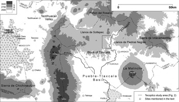
The state of Tlaxcala (Figure 1) lies east of the more intensively explored Basin of Mexico. Its cold and arid climate and its easily eroded soils of volcanic origin are very similar to those of the northern half of the Basin (Werner Reference Werner1988). It is thus an equally unlikely setting for swidden agriculture. Settlement surveys in Tlaxcala documented numerous Formative sites, some of them apparently associated with sophisticated terracing systems and water management devices (Abascal Macías Reference Abascal Macías1980; Abascal Macías and García Cook Reference Abascal Macías and Cook1975; Merino Carrión Reference Merino Carrión1989). The implied precocity of agricultural intensification was in line with other discoveries of early irrigation canals in the tierra fría of the Neovolcanic Axis (Fowler Reference Fowler1987; Nichols Reference Nichols1982) and seemed to confirm the impracticability of swidden in the entire region. Indications of accelerated soil erosion during the latter part of the Formative (ca. 650 b.c.–a.d. 100) (Heine Reference Heine1976, Reference Heine1978, Reference Heine2003; Werner Reference Werner1986) were interpreted as a correlate of large populations supported by intensive forms of cultivation.
Tlaxcala.

In the course of field research in central and northern Tlaxcala we came across sediments of mostly alluvial origin that we believe to reflect some form of swidden cultivation practiced during the Formative and Classic periods. This discovery ran against all the predictions of agricultural ecology and ethnography, the conclusions of previous archaeological research, and our own expectations. The purpose of this paper is to report on the particulars and try to gauge to what extent they require a revision of our understanding of pre-Hispanic highland agriculture.
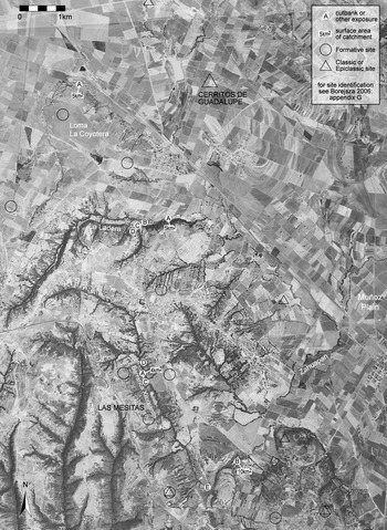
The observations we made come from an arbitrarily delimited study area of 100 km2 centered on the village of San Lucas Tecopilco (Figure 2), at altitudes that range between 2,450 and 2,650 m asl. The area straddles the gently rolling Muñoz Plain and the northern edge of the tectonically uplifted Block of Tlaxcala. The latter has a much more broken relief and supports a mosaic of active and abandoned sloping-field terraces of the metepantle variety (Whitmore and Turner Reference Whitmore and Turner2001:136–143), isolated patches of secondary oak wood, and badlands where erosion has uncovered an indurated subsoil known as tepetate (Etchevers et al. Reference Etchevers, Hidalgo, Prat, Quantin and Lal2003), which precludes any plant growth. The slopes are heavily dissected by the headwaters of several small but deeply entrenched streams with ephemeral flow referred to as barrancas.
Tecopilco study area.

Mean annual precipitation is close to 700 mm, with almost 90% of it falling between May and October (CLICOM 2006). Mean temperature varies little from one month to the next, and averages 13.8 °C over the course of the year. Daily temperature amplitudes are more important, and there is a high incidence of frosts during the dry season, with an average of 30 to 50 days, depending on topographic position. The main risk factors in the cultivation of maize are the high inter-annual variability in rainfall and the relatively frequent occurrence of late frosts and hail. It is difficult to mitigate them with irrigation given the flood regime and entrenchment of streams, but the latter was generally less pronounced when farming began in the area (Borejsza Reference Borejsza2006).
The stream cutbanks and the erosional pedestals left amidst the tepetate surfaces expose many stratigraphic sequences of alluvial, colluvial, and cultural deposits. Our fieldwork has relied mostly on the analysis of such opportunistic exposures (see Córdova and Parsons [Reference Córdova and Parsons1997] for a similar approach), complemented by the results of excavations conducted at the Formative site of Las Mesitas (Lesure Reference Lesure2004:62–101). Of particular interest have been the long alluvial sequences recorded along Barranca Xilomantla and the unnamed streams that flow at the foot of the La Ladera scarp and a hill known as Loma La Coyotera (Figure 2). All three have been dated by radiocarbon and span most of the Holocene (Borejsza Reference Borejsza2006:298–349). The three sequences are roughly similar until ca. 1000 b.c. Until that date stream behavior seems to have responded largely to region-wide variations in climate. Since then, however, each of the three has taken a different trajectory, responding to local differences in agricultural land use in each of the drainages. The proximity of that date to the one proposed for the arrival of the first farmers in central Tlaxcala (Lesure et al. Reference Lesure, Borejsza, Carballo, Frederick, Popper and Wake2006) is striking.
At the cutbanks we examined stream catchments, which do not exceed 10 km2. This has been a great advantage in that the sources of sediment can often be pinpointed to the vicinity of one or two specific archaeological sites. Given the short distances from slope to stream valley, we can also expect that the impact of agricultural slope management on stream behavior was more immediate than farther downstream (see Knighton Reference Knighton1998:56–58). The disadvantage of working in headwater reaches is that the streams are confined to very narrow valleys. Rather than move course laterally, they respond to changes in discharge and sediment input by vertical downcutting or backfilling of the valley along roughly the same axis (see Darby and Simon Reference Darby and Simon1999; Waters and Haynes Reference Waters and Haynes2001). Much of the sedimentary record is removed in each incision event, leaving only isolated cutbanks from which to reconstruct any particular segment of their alluvial history.
SEDIMENTARY RECORDS OF THE XILOMANTLA DRAINAGE
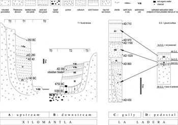
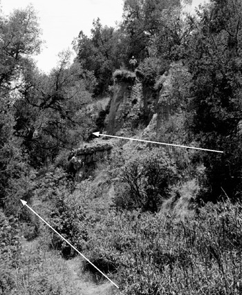
The sediments most relevant to the swidden issue are exposed along the upper reach of Barranca Xilomantla. The valley is confined here between almost vertical walls of unconsolidated sediment that reach 20 m in height. Two classes of valley fill are most conspicuous (Figures 3 and 4). The first is made up of different facies of generally white to pale yellow alluvia that contain bones of extinct megafauna, and are therefore assigned to the Pleistocene. In Figure 3 they are schematically lumped together as T3. The Pleistocene deposits are dissected by narrow U-shaped insets up to 10 m deep (T1), filled with bedded sands and muds that contain sherds. These mark the course of a barranca older than the modern one, but younger than ca. 900 b.c., when the first ceramic artifacts appear in this part of Tlaxcala. Whatever alluvia had been aggraded in the intervening Early to Middle Holocene must have been removed by the incision event that created the Late Holocene T1 barranca.
Schematic cross-sections of sedimentary sequences of the Xilomantla and Ladera drainages. Vertical scale approximate. No horizontal scale is implied.

Barranca Xilomantla at point A with arrows marking the approximate elevation of the modern and Formative period channels.

The most noteworthy aspect of the Late Holocene valley fill is that the sand and mud layers are interbedded with laminae of charcoal. Their concentration varies, but they are present throughout the entire depth of T1. The charcoal includes whole branch fragments, with recognizable wood or bark structure. In one layer we recovered a complete charred leaf that still preserved its vein pattern. Some wood fragments do not even appear to be completely charred. There are also very thin white membranes that preserve the imprint of some sort of plant tissue, perhaps of rootlets or leaves of monocot plants that grew on the floodplain. They often line pores that also have manganese-stained bluish coats of clay and rust-colored mottles.
A sample of charcoal from one such layer taken at point C (Figure 2) yielded enough carbon to obtain a conventional radiocarbon date. The result, 200–90 b.c. (Table 1), pointed to the relevance of the deposits to Formative period archaeology and prompted the formal description and sampling of a 9 m-long sedimentary sequence at point A (Figure 4).
Radiocarbon dates cited within text.

All dates except Beta 157073 are by AMS.
The bottom of this sequence is marked by a wavy unconformable boundary with the indurated alluvium of Pleistocene age. Three sedimentary units can be distinguished. The oldest one, Unit IV, is not thicker than 40 cm, but its sharp and inclined upper boundary suggests that part of it may have been scoured away. It consists of two rather fine-textured and organic-rich zones that preserve some vestiges of bedding, separated by a bed of sand. It reflects intermittent deposition that allowed for some plant growth at the bottom of the newly incised valley and very weak pedogenic modification of the alluvium. Unit V is a 4.4 m-long sequence of horizontally stacked sands and muds. The individual layers range from less than one millimeter to about three centimeters. Their texture and rhythmicity vary from one zone to another. The top 1.5 m of this unit have been modified by soil formation and enriched in organic matter. The original bedding has been masked by pedogenic processes, but its former presence is revealed by the permanence of the horizontal lines of charcoal. This soil is best described as a cumulic A horizon, which indicates that aggradation had slowed down in comparison with underlying zones, allowing more sustained plant growth in the barranca. The boundary of Units V and VIa is sharp, but at the same time smooth and horizontal, suggesting that the contact is conformable. Unit VIa is 4.1 m thick, pale buff in color, and displays bedding planes throughout its entire depth. The laminae or beds are generally thicker and coarser-textured than in Unit V and can measure up to 7 cm without easily apparent internal differentiation. The bedding planes are often wavy, and local cross-bedding is common. Many beds are inclined towards the valley axis. In general terms the unit coarsens upward, and its upper third is almost pure sand. A weak pedogenic imprint can be observed to extend down from the modern ground surface. Unit VIa thus marks the resumption of aggradation and a progressive increase in stream energy, leading up to a renewed incision of the barranca. This one was much deeper than the previous one, so that even today Units IV through VI remain at an elevation well above the active channel.
Charcoal is abundant throughout all three units, and fragments suitable for accelerator mass spectrometry (AMS) dating can be recovered at any desired depth. Units IV and V have the highest concentration of charcoal and the largest fragments thereof. Uncharred wood and fiber impressions are practically limited to these two units. The charcoal seems to be preferentially associated with the finer beds. Part of it probably floated near the surface of the water and settled out in the recessional stage of floods, together with the finer sediment. In the top zones of Unit V, modified by soil formation, and in most of Unit VIa the charcoal is more dispersed and fragmented.
The whole sequence represents the vertical accretion of flood deposits in a near-channel environment, in a narrow barranca whose confined floodplain did not allow much lateral sorting of sands and fines. The aggradation must have been very rapid throughout most of the sequence, as pedogenic development is limited, and the charred and uncharred plant remains could only have been preserved by rapid burial. The distribution of these fossils, as well as sedimentary structures and pedogenic attributes would rank the aggradation of Unit IV as slowest. That of Unit V was more rapid at first, but slowed down considerably in its upper third. Unit VIa aggraded most rapidly of all.
Four charcoal fragments from point A were submitted for radiocarbon dating. The dates span only some 500 years and confirm the extremely rapid pace of aggradation. The bottom of Unit V yielded a date of 190–90 b.c., practically identical to the one from point C. The limited thickness of Unit IV suggests that the incision that created the T1 barranca occurred shortly before 200 b.c. The second dated fragment was recovered close to the bottom of the cumulic A horizon, where we have inferred a significant reduction in the pace of aggradation. At a.d. 1–80, the midpoint of this date is approximately two centuries distant from that of the previous one, but at 2σ intervals the two dates actually overlap. Given how concentrated the charcoal is in Unit V, we think that the flood events responsible for its deposition occurred immediately after the plant matter burnt. The dates obtained thus approximate the time of deposition.
The two dates obtained from Unit VIa are to be interpreted more cautiously, as the charcoal is generally more dispersed and therefore more likely reworked. The date from the bottom of the unit, a.d. 220–340 leaves some 200 years for the slow aggradation and development of a cumulic A horizon at the top of Unit V. The date from the top of Unit VIa, 290–230 b.c. is older than all other dates in the sequence and therefore stratigraphically inverted. This confirms the suspicion that some charcoal in Unit VIa has been reworked from deposits equivalent to Unit V, but located upstream from this cutbank.
The incision of Barranca Xilomantla and the height of cutbanks with charcoal laminae gradually decrease towards point E, where an outcrop of basalt forms a nickpoint. A short reach below it is cut into bedrock, but farther downstream the incision generally does not exceed 6 m, and the stream begins to meander between slanted cutbanks obscured by tufts of long grass. Only one exposure was cleaned along this lower reach, at point B (Figures 2 and 3). The number and timing of Holocene cut-and-fill cycles may have been a little different than in the upper reach, but some correlations can be established on the basis of radiocarbon dates and the textural attributes of the sediment.
The alluvia are generally fine-grained and organic-rich here, reflecting slow deposition on the distal floodplain and almost continuous soil formation. Early to Middle Holocene Units I and II, absent upstream of the nickpoint, are preserved here. At the top of Unit III there is a marked increase in sand-sized particles suggesting floods of a higher magnitude, sufficient to reach the distal floodplain. A soil developed from the top of this unit, suggesting a hiatus in aggradation. We speculate that the floods occurred at the time of the rapid deposition of Unit V at point A, while the soil developed in the same time span as its cumulic counterpart upstream. However, practically no charcoal reached point B during the deposition of Unit III.
The next higher unit can be correlated with the sequence at point A with a higher degree of confidence, and is accordingly labeled as VIb. It is generally fine-grained, but preserves vestiges of bedding planes and contains some layers of sand, alternating with more common layers of finer textures. It coarsens upward. It does not contain any distinct laminae of burnt plant matter, but dispersed charcoal is consistently present throughout it. A fragment of it was dated to a.d. 340–440. This is roughly 100 years later than the latest accepted date from the upper reach. It allows us to conclude that at that date charcoal was still delivered to the stream in significant quantities, and that the increase in stream energy was a drainage-wide event.
The recurrent charcoal laminae of Barranca Xilomantla have no modern-day natural analog. To our knowledge, no similar deposits have been described as a result of forest fires or other natural phenomena. They must have been produced by repeated fires provoked by some cultural practice. The two dates from Unit V are separated by 3.35 m of sediment and, taking the midpoints of calibrated ranges at 1σ as a reference, by an estimated 165 years of time. This gives a very rapid aggradation rate, of the order of 2 cm per year. Individual charcoal laminae contained in that interval were never counted, but we estimate that their average recurrence interval does not exceed a few centimeters. As most laminae in Unit V contain extremely high concentrations of charcoal and are remarkably continuous, we suppose that we are looking at an almost one-on-one correspondence between burning events and floods, rather than the redeposition of charcoal from one event by several floods. The wide span of calibration intervals means that these are very rough estimates, but they are sufficient to make us conclude that some part of the catchment upstream of point A was on fire on an annual basis.
Two working hypotheses entertained to explain this phenomenon were production of charcoal for fuel, or the burning of maize stubble after harvest. Both can be refuted. Wood is converted to charcoal in order to yield fuel that weighs little, but has a high calorific yield. It is usually produced in sparsely populated locations with an abundant supply of wood and exported to urban markets. To judge by the abundance of Formative period remains in the drainage, it was densely settled at the time the deposits in question accumulated in the barranca. Urban centers did not emerge in this part of Mexico until the very end of the Formative and the only one that could have generated a massive demand for charcoal was located at a distance of more than 60 km to the northwest, in the Teotihuacan Valley. More importantly, it is difficult to imagine that so much charcoal was allowed to be wasted and delivered by surface runoff to the stream, instead of being delivered for household use. The sheer size of the alluvial landforms discussed here (cutbanks several meters high over a reach more than 2 km long) implies an amount of charcoal that could hardly be produced by the erosion of ovens, kilns, hearths, or other discrete features. It calls for a landscape-scale explanation.
The burning of maize stubble may have been a relatively common agricultural practice, aimed at reducing the depth to which the soil must be turned, arresting the proliferation of weeds, and recycling nutrients into the soil (Guzmán Reference Guzmán1962:404; Wilken Reference Wilken1987:55–57). It would have made particular sense in a pre-Hispanic rural economy with no plow, no domestic animals to be fed on the stubble, and no reliable source of animal manure. However, several charcoal fragments observed while working on the exposures along Barranca Xilomantla preserved the structure of wood, not maize. The δ13C values obtained with the radiocarbon dates range between −21.6‰ and −24.1‰, which indicates a marked dominance of C3 plants. The δ13C values of C4 plants, such as maize, are close to −13‰, whereas the average value for wood is −26‰ (Lowe and Walker Reference Lowe and Walker1997:Table 5.1). Values obtained on Formative maize kernels at the nearby site of Tetel were even higher, ranging between −10.1‰ and −8.4‰ (Lesure et al. Reference Lesure, Borejsza, Carballo, Frederick, Popper and Wake2006:Table 1).
Therefore, the only plausible interpretation we can think of is that the laminae of charcoal are the result of the repeated burning of vegetation dominated by woody shrubs or trees. The clearing of primary forest cover must be excluded. In such a small drainage it could not have kept supplying charcoal to the stream for a period of 200 years. Forest fallow cultivation, with plots being allowed to revert to mature forest, also seems unlikely given the size of the catchment and the recurrence interval of the fires. We would rather imagine a system of bush fallow (Boserup Reference Boserup1965:12) in which the plots were rested for a few years, allowing colonization by woody scrub. This was burnt in preparation for the renewed planting of crops. The burning probably took place at the end of the dry season, at planting time, so that the first rains hit a surface still covered in charcoal and ash that was afforded little protection by the maize seedlings, which were still in the early stages of growth. At any one time there would have existed a mosaic of cultivated and fallowed fields, so that substantial burning would take place every year in at least some parts of the drainage.
Extrapolating evidence from a number of Formative and Classic period sites in Tlaxcala (Borejsza Reference Borejsza2006; Borejsza et al. Reference Borejsza, López, Frederick and Bateman2008) we would guess that this set of practices took place on unterraced slopes. It cannot be directly proven in this particular drainage because ground surfaces of that age are not preserved. Theoretical considerations support this inference, as bush fallow and terrace agriculture are usually placed at rather distant points of the spectrum of agricultural intensity. The repeated destruction of the vegetation cover by fire and the tillage of unterraced slopes would have mobilized a lot of sediment towards the stream. As tepetate surfaces were exposed by erosion, runoff was accelerated and the discharge of the stream peaked at ever higher levels. The frequent rotation of plots that swidden requires, no doubt accelerated by the effects of erosion itself, would have assured that the same destructive pressures were exerted over the entire Xilomantla drainage, and possibly over much of the study area as a whole.
The catastrophic dimensions of the damage inflicted are readily apparent in the sedimentary record itself. The roughly 9 m-deep incision that the barranca suffered shortly before 200 b.c. was likely the end result of the set of processes described above and the response to some particularly violent flood events. By this we imply that the kind of agriculture inferred from the post-200 b.c. deposits had a longer tradition. Older charcoal-rich alluvium may well have existed, but would have been removed by the incision. Slope erosion went on unabated after this date and rapidly filled the newly incised barranca. Our estimate of the aggradation rate (2 cm a year between ca. 150 b.c. and a.d. 50) makes it roughly 20 times more rapid than the rates calculated for pre-agricultural alluvium at cutbanks with similar catchments in the neighboring Ladera and Coyotera drainages (Borejsza Reference Borejsza2006).
As mentioned above, aggradation in Barranca Xilomantla seems to have slowed down between ca. a.d. 50–250, which could reflect a reduction of agricultural activity in the drainage, perhaps in response to the degraded condition of farmland. Thereafter aggradation gained momentum, continuing beyond a.d. 400 until a renewed incision event, more dramatic than the previous one, began and created the modern barranca. At present we have no means of dating this event. It could have occurred as long ago as the Classic period, or as recently as the Colonial period.
It is worth emphasizing that at point A the catchment of the stream is only 4 km2. In such a small area the cutting and re-filling of a 9 m-deep valley would have required sheet erosion extending well into the subsoil, or extensive gullying of the slopes. Numerous scars of past erosional events of great intensity are obvious on the slopes bordering Barranca Xilomantla, in the form of tepetate badlands and gully networks, but they are difficult to date other than by comparison with the alluvial records. Between the barranca and the site of Las Mesitas on its right bank there is an oak wood. Its floor has a very irregular topography that betrays a former badland, with the understory of long grass now partially masking old erosional pedestals. As the natural recovery of tepetate surfaces is very slow, we suspect that in this area they were first exposed by the swidden practices of the Formative or Classic periods.
Excavations at Las Mesitas uncovered several bell-shaped pits and other underground features of Formative period age, but failed to locate any intact ground surfaces associated with them. The soil profiles exposed by excavation, as well as those visible in roadcuts that traverse the site, consist of A horizons (topsoils) with sharp boundaries to strongly developed Bt (clay-enriched) horizons, which belong to an older cycle of soil formation. The pits are dug into the Bt horizons and underlying tepetates and appear in plan only after the sandy topsoil has been removed. This confirms that the pits were truncated by erosion at some point during or after the Formative, and that the topsoil has developed in a layer deposited on the eroded surface thereafter.
Two fragments of charred pine wood from two different bell-shaped pits yielded practically identical radiocarbon dates of 650–550 b.c., which make them a few centuries older than the charcoal-rich alluvium in the barranca. Surface collections of sherds from this and other nearby sites, however, point to a sizeable occupation in both the Texoloc (650–500/400 b.c.) and Tezoquipan (500/400 b.c.–a.d. 100) phases of the Tlaxcalan ceramic chronology (García Cook and Merino Carrión Reference García Cook, Carrión, Puche and Cáceres1988; Lesure et al. Reference Lesure, Borejsza, Carballo, Frederick, Popper and Wake2006). No fewer than four “dispersed villages” belonging to these phases have been isolated by survey teams in the drainage (Figure 2) (García Cook Reference García Cook1972; Lesure Reference Lesure2002:53–72; Snow Reference Snow1966). The sherd scatters confirm an important and long-lasting presence of Formative period farmers, but as they are usually found redeposited on younger surfaces they tell us little else.
SEDIMENTARY RECORDS OF THE LA LADERA DRAINAGE
La Ladera (‘the slope’) is a place-name used to refer to a steep scarp north of San Lucas Tecopilco. It is the upthrust member of a west-east trending tectonic fault that has created an asymmetric valley followed by the trunk stream of the La Ladera drainage. The sedimentary record of Holocene age is very fragmentary. The only long alluvial sequence was described on the right bank at point B. It represents the distal floodplain facies of a barranca that existed between the end of the Pleistocene and ca. a.d. 1000. Relatively little deposition is recorded in the interval where we would expect agricultural impacts, and no charcoal is present. It is not clear how representative this sequence is, however, as we would expect more alluviation on the left, downthrust side of the valley, where few cutbanks are available for inspection.
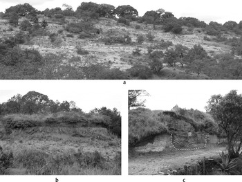
The scarp itself is covered by a forest of pine and oak. In several places the trees and their understory conceal the irregular floor of old tepetate badlands. A largely unvegetated and therefore presumably younger badland is present just upstream from point B (Figure 5A). Here we described the stratigraphy (Figure 3) visible in an erosional pedestal (Figure 5B, point D) and that of an infilled gully at the downslope end of the badland, exposed in a roadcut (Figure 5C, point C).
La Ladera: (a) panorama of tepetate badland; (b) erosional pedestal at point D; and, (c) infilled gully at point C (dashed line marks approximate extent of charcoal-rich Unit I).

The gully cuts into white-colored deposits of Pleistocene age. In the lower left corner of the exposure there is a wedge of an old fill of the gully, most of which was flushed out prior to the deposition of units I through IV (Figure 3). Unit I is the thickest and the one of immediate concern to us. It consists of a succession of bedded sands and muds. The proportion of sands generally increases upwards. There is abundant charcoal, preferentially associated with the finer-textured beds. This confirms our inference, made in Barranca Xilomantla, that the charcoal was transported floating, or in suspension near the surface of the water. Here, the charcoal does not occur in the form of distinct laminae, but is nonetheless extremely abundant. Most of it comes in the form of splinters that do not exceed a few millimeters, but in some beds fragments up to 1.5 cm in diameter are consistently present. It is not difficult to observe planes on which the charcoal fragments take up more than 5% of the surface area. A lens of charcoal and sediment reddened by fire, apparently burnt in situ, was found in the upper half of the unit. A few large and relatively unabraded sherds were recovered from Unit I, but none of them were chronologically diagnostic.
As in Barranca Xilomantla, the concentration of charcoal indicates that it must have been produced by some activity that took place in the immediate vicinity and just prior to its entrainment and deposition at the bottom of the gully. In any case, given the short stretch of slope above point C and its shape, there must have been a source of charcoal within a few hundred meters. We are thus confident that the two radiocarbon dates from Unit I mark the actual time of deposition. According to these, the gully fill started to aggrade shortly before a.d. 380–470. The incision that had flushed out older gully fills probably occurred close to this date, too. The aggradation of Unit I continued at least until a.d. 810–900, the date obtained from its very top. More fill of a similar nature may have accumulated in the gully after this date, as the upper boundary of Unit I is very wavy and indicates some scouring of the surface of the gully fill before the deposition of the next higher unit.
The deposition of Unit I thus spans some 450 years. The sedimentation rate that can be estimated from this is of the order of 0.5 cm per year. This is about a quarter of what we calculated for Unit V at Xilomantla A, but we are also dealing here with a much more reduced catchment, which could hardly have exceeded 20 ha. Severe, but possibly very localized erosion is thus indicated. The dark color of Unit I, especially of its fine-textured beds, suggests a high content of organic matter. As indices of in situ soil formation are very weak, much of the organic matter must be redeposited from upslope. We would thus imagine that in this time span erosion, though severe, did not penetrate much into the subsoils, but rather stripped the local topsoils in a sheet-like fashion.
Although pieces large enough to be identified as wood with the naked eye are rare, the very low δ13C values associated with the two radiocarbon dates again suggest that the charcoal is derived from the burning of plant matter dominated by shrubs or trees. It could have come from the burning of secondary vegetation in agricultural plots that had been left fallow, according to the set of erosion-prone farming practices discussed at length in the section devoted the Xilomantla drainage. Another possibility is that a hamlet existed within the 20 ha in question, and that the charcoal is derived primarily from the burning of fuel wood in and around the houses. Under this scenario, the charcoal would have been incidentally incorporated in the sediment eroded from the slope, due its agricultural management, or for some other reason.
The overlying Units II through IV reflect the stripping of the slope of progressively deeper and less organic soil horizons, and the creation of the tepetate badland. We estimate that it occurred between ca. a.d. 1000 and the Colonial period (Borejsza Reference Borejsza2006:331–341, 385–399) and was driven by both land use and climate change, but discussion of the exact timing and causes of this process is beyond the scope of this article. In Units II through IV there is nowhere near the quantity of charcoal contained in Unit I, and we do not posit any relationship between swidden practices and the later stages of erosion.
The stratigraphic sequence observed at point D, some 150 m upslope, though not dated by radiocarbon, can be correlated with the gully fills on the basis of sediment and soil characteristics, in a way that both affirms and refines our interpretations. The sequence is exposed in a roughly 2 m-high pedestal, which is a remnant of the sediments and soils that mantled the slope before the last episode of severe erosion, the one that created the modern tepetate badland, at some point within the last 500 years. The base of the pedestal is taken up by a tepetate not described in detail. It is overlain by a thin dark-brown layer with a strongly developed structure of angular peds, with prominent clay coats (Unit I). This may be the remnant of an old Bt horizon, or the bottom part of a clay-rich A horizon. On top of it is a lens of earth reddened by fire and indurated to the hardness of brick. Some of it seems to be the clay-rich Unit I baked in situ, while other fragments resemble burnt daub. At the foot of the pedestal, directly in front of where the lens was spotted, is a scatter of heavily burnt daub fragments, some with clear impressions of wooden beams. In the pedestal, a charred branch rested next to this lens. We conclude that a house stood here and that the top of Unit I represents an old occupation surface. Given how thin Unit I is, however, it seems likely that the original pre-settlement ground surface was at a higher level and that much of it had already been eroded by the time that this particular house was built. Units II and III are the result of two more episodes of deposition, separated by an episode of soil formation that testifies to slope stability. The deposition of Unit III was followed by the erosional event that created the pedestal.
The dark color and fine texture of Unit I of the pedestal being comparable to that of the mud layers of Unit I of the gully fill, we speculate that the latter was derived from the erosion of the former. The house in question would have been built late in the interval (ca. a.d. 400–900) inferred for the aggradation of the bottommost gully fill, when the pre-settlement soil had already been truncated. It could not have been built long after a.d. 1000, because the sediment that buried it (Unit II at point D) is the same one that started to accumulate in the gully (Unit III at point C) at roughly that date.
We can thus confirm the existence of human abodes (and speculate on the existence of adjacent fields) within the tiny catchment area of the gully at a time when it was receiving very high inputs of charcoal. This falls within the Classic (a.d. 150–750) and Epiclassic (a.d. 750–950) periods. No sherd scatters of that age have been reported from the La Ladera drainage, and evidence of those periods is in general extremely scant in the study area, especially in comparison to the preceding Formative. The one exception to this pattern is the site of Cerritos de Guadalupe, located on the plain north of Loma La Coyotera (Figure 2). Merino Carrión (Reference Merino Carrión1989:75) reported 40 mounds and a 150-ha scatter of artifacts stylistically related to Teotihuacan. The size and sophistication of the settlement is difficult to appreciate today because most mounds have been bulldozed to provide fill for a nearby dam, but we have little doubt that this was a large town that nucleated much of the population of the study area and shifted its center of gravity to the north.
Nucleation of settlement, a shift from uplands to plains, and the spread of metropolitan culture along the “Teotihuacan corridor” where the site is located are patterns that have been described at scales much larger than our study area (García Cook Reference García Cook and Sabloff1981:266–269; García Cook and Trejo Reference García Cook and Trejo1977). Charcoal-rich sedimentary records, however, span both sides of this chronological watershed in the Xilomantla drainage, and appear at one point in the Ladera drainage after the transformation. If we accept them as evidence of swidden agriculture (something that we still hesitate to do in the Ladera case), we are led to the conclusion that the change in settlement pattern observed in the study area between the Formative and Classic periods did not result in a fundamental and lasting change in the ways that slopes were farmed. Many farmers may have moved houses to a more urban setting, but still returned to their fields to slash and burn the brush, managing the land in the same extensive and erosion-prone way. If we sought to infer agricultural practice from settlement pattern and ethnographic analogy alone, we would likely err in this case.
THE NATURE AND IMPORTANCE OF SWIDDEN IN THE COLD HIGHLANDS
The notion that the large and socially complex populations of the Terminal Formative and Classic periods practiced swidden in an environmental setting where no eyewitness has ever recorded its feasibility will no doubt raise some eyebrows. The ecological incongruence is perhaps the less disturbing one. Both Nichols (Reference Nichols1987) and Sanders (Reference Sanders1965) have at some point entertained the idea that swidden was practiced by the first farmers who settled the tierra fría, but thought it was not sustainable in the long term. For Nichols, it began to be replaced by other agricultural systems before 600 b.c., while Sanders set the transition at ca. 100 b.c. With evidence from around Tecopilco in hand we have suggested that it was perhaps practiced as late as a.d. 800, well into the period when Mesoamericans are generally accepted to have formed state-level societies. The dates may of course be different for the different regions we have focused our attention on, and if, as has been suggested (García Cook Reference García Cook and Sabloff1981) the Tlaxcalan uplands became a sparsely populated backwater after the Formative period, the later date would make some sense. Still, state and swidden are difficult to reconcile, and it is therefore incumbent on us to specify what kind of swidden we imagine feasible, and how widespread we think it was.
As has already been made clear, we should be wary of pointing to any particular “traditional” system of cultivation as a living image of what might have gone on in prehistory (see Halstead Reference Halstead1987). The use of ethnographic examples becomes indispensable at a certain level of interpretation, but any model of prehistoric swidden can only be assembled from several piecemeal analogies and should be anchored in at least some archaeological field evidence. We hope to refine the latter by means of a microstratigraphic analysis of the sediments that will quantify the amounts of charcoal present and seek cyclical patterns in the association of charcoal laminae with individual flood events. Even more urgent is the task of taxonomic identification of the charred plant remains that will serve to reconstruct the fallowing regime: a prevalence of slow-growing tree species will point to longer fallows than one of fast-growing shrubs and herbaceous plants. Until such analyses are completed, the choice of relevant ethnographic analogs is obviously tentative.
We do not wish to revive tlacolol as a term, as it is indeed problematic as a wholesale analog for Formative or Classic period agriculture in the tierra fría. As is clear from descriptions by Lewis (Reference Lewis1960) and Córdova (Reference Córdova1991), it is practiced in a much hotter climate where vegetation regenerates faster, and on soils derived from limestone or basalt, which are generally poorer in nutrients but less erodible than those derived from the unconsolidated pyroclastics of the Neovolcanic Axis. The slopes are littered with stones, which make tillage difficult, but at the same time act as natural mulch protecting the ground surface from erosion. The vegetation is cut with machetes or other steel tools.
There are some hints that between approximately 1000 b.c. and a.d. 1000 the climate of central Mexico was slightly moister than today (Caballero et al. Reference Caballero, Lozano, Ortega, Urrutia and Macías1999; Frederick Reference Frederick1995; Lozano García and Vázquez Selem Reference Lozano García and Selem2005; Metcalfe et al. Reference Metcalfe, O'Hara, Caballero and Davies2000; Ohngemach and Straka Reference Ohngemach and Straka1983). Together with the no doubtless depleted seed banks of tree and shrub species, and less isolated refuges of natural vegetation, this would have allowed more rapid recolonization of fallowed fields. At no time throughout the Holocene, however, were the climatic shifts large enough to induce in Tlaxcala the growth of tropical deciduous forest or similar vegetation communities managed by tlacolol.
It is also clear that the social and economic context of tlacolol is quite different from the one that would have obtained in Formative or Classic Tlaxcala. Tlacolol is practiced only by the poorest peasants who do not own enough land amenable to plow cultivation. It is practiced in the village commons, often located in remote places. In Tepoztlan, where the villagers traveled up to three hours to their fields, it was considered worthwhile only for those who could not meet their subsistence needs otherwise. It is labor-intensive, not the least because of the costs of transport and the need to fence out livestock. In modern-day Guerrero, tlacolol is also apparently considered worthwhile by those who plant crops that have a very high commercial value, but can only thrive in out-of-sight places (Habana de los Santos Reference Habana de los Santos2005).
Some of the observations from Huehuetenango offer clues that are missing from the descriptions of tlacolol. Near villages that are within the altitudinal zone of the tierra fría, forest takes more than 50 years to regenerate and is rarely allowed to do so. This interval would have been even longer in the somewhat drier climate of Tlaxcala and is out of the question given the close recurrence interval of charcoal laminae. A woody bush, referred to as huatal, springs up in many fallowed plots without the intermediate stage of grassland. If a similar succession of vegetation communities took place on the Tlaxcalan slopes, we may be looking at a “bush,” not “forest,” fallow regime on the order of 4–5 years following 2–3 years of cultivation. Unfortunately, there have been no systematic surveys of secondary vegetation in Tlaxcala itself and they would be difficult to apply to the pre-Hispanic past because today the successions are heavily conditioned by grazing, the collection of firewood, and the impoverished soils.
The farmers of Huehuetenango recognize that tillage eventually destroys the underground stock from which the woody vegetation regenerates, and the fallowed fields are invaded instead by grasses, which are more difficult to remove and lengthen out the plant succession necessary to restore fertility. Measures are taken to reduce tillage to a minimum. Maize is usually planted without any tillage, but the soil has to be turned later on in the growing season, during weedings, or when the plants are hilled. To judge by the amount of soil erosion documented in Tlaxcala, some form of tillage was taking place. If it had the same deleterious effect of encouraging relatively long-lived grass communities, many slopes would have experienced more rapid runoff and erosion even before the formation of tepetate surfaces. In one of the Guatemalan villages, in exceptionally dry years, the bush is burnt without being cut (Stadelman Reference Stadelman1940:Note 25). Depending on how often this was feasible in Tlaxcala, the most laborious part of the swidden cycle, and one that often raises theoretical objections, could be reduced or eliminated.
We thus imagine the Formative period management of slopes as resembling in some aspects the tlacolol practiced in Morelos and Guerrero, in others the management of high elevation huatales in Guatemala, and in some ways unique. The huatal example is perhaps the closest analog in terms of climatic conditions. The relevance of tlacolol, on the other hand, is that it is known to be practicable in the zone of tropical deciduous forest immediately south of the Neovolcanic Axis. It is in that zone that many scholars place the origin of maize, of Mesoamerican agriculture, and of farmers who eventually colonized the oak-and-pine forests of the Basin of Mexico, Tlaxcala, and other regions along the Axis (Benz Reference Benz and Blake1999; Parsons et al. Reference Parsons, Brumfiel, Parsons and Wilson1982:365–366; Piperno et al. Reference Piperno, Moreno, Iriarte, Holst, Lachniet, Jones, Ranere and Castanzo2007). We would speculate that apart from maize, farmers brought with them a set of tlacolol-like swiddening practices, and that tradition prevailed over the pressures to adapt them to the new environment as long as land was plentiful.
The unique aspect of prehistoric swidden in Tlaxcala and environmentally similar regions, the one that must remain without ethnographic analog, was the irreversible damage that it wrought. The permanent removal of the forest cover, the periodic removal of the shrub cover, the inadvertent encouragement of grassland, and the tillage of the highly erodible soils accelerated runoff and sediment transfer to levels unprecedented under natural conditions. The exposure of tepetate surfaces, the gullying of slopes, and the deep incision of many streams left the farmland in a degraded condition, which not even the longest fallow could remedy by itself.
One may raise the objection that the amount of evidence amassed here does not warrant such an apocalyptic vision. No charcoal laminae comparable to those of Barranca Xilomantla have been observed in other barrancas that we have surveyed so far in Tlaxcala. We are inclined, however, to blame this on the vagaries of charcoal dispersion and recruitment to sediment. Comparisons of eyewitness histories of forest fires and charcoal inputs in lake sediments (MacDonald et al. Reference MacDonald, Larsen, Szeicz and Moser1991; Whitlock and Millspaugh Reference Whitlock and Millspaugh1996) reveal a disturbing lack of correlation and bring out the complex interplay of factors—the nature of the fuel, prevailing wind directions, the timing of rains, modes of sediment transfer—that determines whether fires find an expression in the proxy record. It is to be expected that in the much more fragmentary alluvial records the preservation of charcoal is subject to extremely severe taphonomic constraints. The exceptional circumstances that have favored preservation in Barranca Xilomantla are probably due to the narrowly elongate shape of the upper part of the drainage, assuring very short distances between the sources of charcoal and the stream channel, as well as to the narrow and deep incision that occurred after a.d. 400, putting the charcoal-rich sediments beyond reach of the active channel and frequent wetting and drying.
Evidence of deforestation and accelerated soil erosion is easier to come by than unequivocal evidence of burning, and several examples have been documented in the tierra fría for the Formative period. Heine (Reference Heine1976, Reference Heine1978, Reference Heine2003) concluded from the inspection of several alluvial sequences in Tlaxcala and neighboring Puebla that one of the major episodes of erosion of the last 3,000 years took place during the Tezoquipan ceramic phase. The conclusions that Sanders drew from site distributions in the Teotihuacan Valley are to some extent substantiated by the radiocarbon dates on buried soils, particularly in the upland zone (McClung de Tapia et al. Reference McClung de Tapia, Rubio, Castro, Solleiro and Sedov2005). Several of them seem to have been buried during the Formative period, before the city of Teotihuacan was built. In the Texcoco region to the south, an episode of slope degradation dated to ca. 200 b.c.–a.d. 100 is recorded in the alluvial deposits of the Papalotla and Coatepec rivers (Córdova Reference Córdova1997:319–331, 350–361, 367, 481). Yet farther south, in the Chalco region, the alluvial stratigraphy preserves a record of dramatic debris flows during the Formative (Córdova Reference Córdova1997:512–513; Frederick Reference Frederick1996). At Santa Clara Coatepec, on the western side of the Basin of Mexico, the level of the alluvial plain rose seven meters during a relatively short period between ca. 900 and 650 b.c., as suggested by a series of buried irrigation canals that contain ceramics dating exclusively to the local Ecatepec phase (Nichols Reference Nichols1982; Sanders and Santley Reference Sanders and Santley1977). The sediment was delivered by a relatively small stream exiting the Sierra de Guadalupe, and its aggradation reflects, according to Nichols, the erosion provoked by swidden cultivation of unterraced slopes within that range of hills. Pollen and other proxy records from the lakes that once occupied the floors of the Basin of Mexico and the Toluca Valley to the west hint at human disturbance of the environment at early dates (Lozano García and Ortega Guerrero Reference Lozano García and Guerrero1994; Lozano García et al. Reference Lozano García, Nájera, Sugiura and Caballero2005), but the low sedimentation rates make it difficult to tie them to the archaeological record. In the latter case, the high counts of microscopic charcoal recorded for the Formative and Classic periods are correlated with declining values of arboreal pollen.
We predict that on closer inspection some of these examples will be causally linked to extensive forms of agriculture. The overrepresentation of fire-resistant species of pine in the secondary forests of Tlaxcala and the Basin of Mexico (Ern Reference Ern1972; Rzedowski Reference Rzedowski, Rzedowski and Rzedowski2001) may also turn out to have its roots in the depletion of the stock of other trees by the swiddening regime applied in the Formative period.
We do not mean to deny that Formative and Classic period farmers were capable of devising more labor-demanding and technologically sophisticated systems of cultivation. There are several examples to the contrary, particularly in the realm of irrigation (Doolittle Reference Doolittle1990, Reference Doolittle2006). Given the inherently higher archaeological visibility of intensive agriculture, however, we would urge caution in using sustained population growth and cultural florescence as final proof of agricultural intensification. We think that even by the end of the Formative period the absolute acreage of cultivable farmland was much larger than today, after two more thousand years of largely cumulative degradation. We therefore contend that Tlaxcalan farmers responded to demographic pressures not by intensifying agricultural production on sloping land, but by opening it up for cultivation and degrading ever greater expanses of land. The ingenious ridge-and-furrow system preserved under volcanic ash at Tetimpa (Plunket and Uruñuela Reference Plunket and Uruñuela1998, Reference Plunket and Uruñuela2005:95–101; Seele Reference Seele1973) and the canals at Amalucan (Fowler Reference Fowler1987) give us reasons to believe that the spatial expansion of swidden was complemented by the intensification of the agricultural management of a few favored pockets of the landscape. Apart from the wetlands of the Puebla-Tlaxcala Basin (where Amalucan is located), they may have included the relatively wide floodplains of some streams that have since been transformed into deep barrancas. Even though there is a time-honored tradition of putting irrigation at the high end of an evolutionary sequence of which swidden is the starting point, each was probably aimed at a slightly different ecological niche, and instances where one directly supplanted the other were few.
RESUMEN
En varias partes del mundo la agricultura de roza ha sido descartada como un análogo relevante para la reconstrucción de los sistemas de cultivo prehistóricos. En Mesoamérica se la considera factible en la tierra caliente y templada (abajo de los 1750 m snm) y típica de comunidades relativamente pequeñas y aisladas. No existen relatos de que haya sido practicada en las tierras frías del altiplano central. Sin embargo, sedimentos ricos en materia vegetal carbonizada, recientemente descubiertos en Tlaxcala, sugieren que sí lo fue durante los períodos formativo y clásico. Las cabeceras de la Barranca Xilomantla que recoge los escurrimientos de una pequeña cuenca en el centro del estado cavaron un cauce de nueve metros de profundidad un poco antes de 200 a.C., para acomodar caudales incrementados por la erosión antropogénica de las laderas. Lo volvieron a llenar dentro de unos cuantos siglos, de arenas, limos y arcillas estratificados. Entre éstos se encuentran cientos de láminas de carbón, las que reflejan al parecer la quema anual de vegetación secundaria en terrenos en los que concluía un periodo de descanso arbustivo. En la localidad vecina de La Ladera, una cárcava ubicada en la orilla de un caserío prehispánico recibió aportes significativos de carbón entre 400 y 900 d.C. El conjunto de prácticas agrícolas que se puede inferir a partir de estos depósitos no tiene ningún análogo etnográfico, aunque reunía quizás algunas características del tlacolol de la tierra caliente y del manejo de los huatales de Huehuetenango. Ocasionó una degradación duradera de los terrenos de cultivo ubicados en las laderas, pero siguió practicándose por varios siglos, a pesar de profundos cambios en los patrones de asentamiento. Los sistemas de riego desarrollados en el altiplano desde el formativo parecen haberse enfocado en terrenos de menor pendiente y no sustituyeron la agricultura de roza de manera directa.
ACKNOWLEDGEMENTS
This research was funded by the Wenner-Gren Foundation and the National Science Foundation (grants 0310478 and 0003961) and authorized by the Instituto Nacional de Antropología e Historia. Jennifer and David Carballo directed the excavations at Las Mesitas. We wish to thank Margarito Hernández López and Carol Schultze for assistance in the field, and Gaudencio Vázquez and Wiliulfo Mejorada Díaz for permission to work on their land. The manuscript was written while one of us (Borejsza) enjoyed the extra time granted by a postdoctoral fellowship of the Coordinación de Humanidades of the Universidad Nacional Autónoma de México, held at the Instituto de Investigaciones Antropológicas. Emily McClung de Tapia, Carlos Córdova, and Jay Silverstein provided comments that improved the manuscript and stimulated our thinking on its subject matter.