1. Introduction
Triassic rifting in the North Atlantic is relatively poorly understood due to the limited outcrop, the scarcity of offshore data and poor dating constraints. This study therefore provides a key data point for the region and can help us understand the rifting history of the wider North Atlantic. Furthermore, the Triassic strata of East Greenland provide an important succession for the application of palaeoclimatic studies such as those previously undertaken on orbital forcing, the Carnian Pluvial Event and long-term climatic trends (e.g. Clemmensen et al. Reference Clemmensen, Kent and Jenkins1998; Andrews et al. Reference Andrews, Kelly, Braham and Kaye2014; Decou et al. Reference Decou, Andrews, Alderton and Morton2016). We therefore aim to advance our understanding of the basin evolution during the Triassic Period, and to provide a robust framework for future research.
The Triassic System of East Greenland has been the subject of comparatively little research due to its remote location and challenging environment (Grasmück & Trümpy, Reference Grasmück and Trümpy1969; Perch-Nielsen et al. Reference Perch-Nielsen, Birkenmajer, Birkelund and Aellen1974; Clemmensen, Reference Clemmensen1977, Reference Clemmensen1978 a, b, Reference Clemmensen1980 a, b; Bromley & Asgaard, Reference Bromley and Asgaard1979; Clemmensen et al. Reference Clemmensen, Kent and Jenkins1998; Seidler, Reference Seidler2000; Seidler et al. Reference Seidler, Steel, Stemmerik and Surlyk2004). The rich vertebrate fauna of the region has more recently rejuvenated interest in the area (e.g. Jenkins et al. Reference Jenkins, Shubin, Amaral, Gatesy, Schaff, Clemmensen, Downs, Davidson, Bonde and Osbæck1994; Kent & Clemmensen, Reference Kent and Clemmensen1996; Clemmensen et al. Reference Clemmensen, Kent and Jenkins1998, Reference Clemmensen, Milàn, Adolfssen, Estrup, Frobøse, Klein, Mateus, Wings, Kear, Lindgren, Hurum, Milàn and Vajda2016; Milàn et al. Reference Milàn, Clemmensen and Bonde2004; Klein et al. Reference Klein, Voeten, Haarhuis and Bleeker2016; Marzola et al. Reference Marzola, Mateus, Shubin and Clemmensen2017; Agnolin et al. Reference Agnolin, Mateus, Milàn, Marzola, Wings, Adolfssen and Clemmensen2018), but these studies have been of a very focused nature. The work of Clemmensen (Reference Clemmensen1980 a, b) and, to some extent, Perch-Nielsen et al. (Reference Perch-Nielsen, Birkenmajer, Birkelund and Aellen1974) provided the framework for the few later studies. More recently a revision of the stratigraphic nomenclature, with an emphasis on the uppermost portions of the stratigraphy, was presented by Clemmensen et al. (Reference Clemmensen, Kent, Mau, Mateus and Milàn2020). These revisions are followed here although some amendments are suggested. By targeting areas previously lacking in data and revisiting localities highlighted as key by earlier workers, this study updates and expands our understanding of the Triassic sedimentary systems and basin evolution in East Greenland.
The stratigraphy and sedimentology of each group is described in turn and the implications for basin development are discussed. The provenance of the sediments is then described, linking the basin fill to its catchments, using both conventional heavy mineral ratios and garnet single-grain geochemistry. In light of recent biostratigraphic revisions (Andrews et al. Reference Andrews, Kelly, Braham and Kaye2014), the East Greenland succession is also placed within the wider regional context of the North Atlantic/Norway–Greenland Rift.
2. Geological background
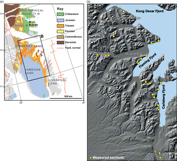
The Jameson Land Basin is located in East Greenland between 70° 05′ and 73° N (Fig. 1). Lower Triassic strata (Wordie Creek Group) occur as far north as Kap Stosch, but the overlying continental Triassic succession is most continuously exposed in the Jameson Land, Scoresby Land and Liverpool Land regions, with minor outcrops recorded from the Mols Bjerge on Traill Ø and further north on Geographical Society Ø (Andrews & Decou, Reference Andrews and Decou2018; Andrews et al. Reference Andrews, Decou, Braham, Kelly, Robinson, Morton, Marshall and Hyden2020) (Fig. 1). Aligned broadly N–S, the Jameson Land Basin is approximately 280 km long and 80 km wide, and contains Middle–Late Triassic fill of thickness > 1.5 km. During the Middle Triassic Epoch, Jameson Land was positioned in the northern arid belt, 15–30° north of the equator (Kent & Clemmensen, Reference Kent and Clemmensen1996), resulting in an arid to semi-arid climate. By the Early Jurassic Epoch, Jameson Land had drifted to around 40° N. This had a significant effect on depositional systems within the basin (Decou et al. Reference Decou, Andrews, Alderton and Morton2016).
(a) Geological map of the Jameson Land Basin with key localities labelled, and (b) a digital elevation model, indicating the position of examined sections.

The Middle–Upper Triassic succession of East Greenland consists of the coarse, predominantly alluvial, clastics of the Pingo Dal Group, which are overlain by the fluvio-lacustrine mudstones and sandstones of the Gipsdalen and Fleming Fjord groups (Fig. 2). Dating of the succession is poor, as is often the case in continental deposits. However, the recent biostratigraphic work of Andrews et al. (Reference Andrews, Kelly, Braham and Kaye2014) has significantly improved dating constraints (Fig. 2). The lithostratigraphic scheme erected by Clemmensen (Reference Clemmensen1980 a), and revised by Clemmensen et al. (Reference Clemmensen, Kent, Mau, Mateus and Milàn2020), is broadly followed here (Fig. 2). However, minor amendments to the position of the Rødestaken Formation, the definition of the Gråklint Member and re-allocation of the Kolledalen Formation are suggested, alongside a revision of the subdivisions of the Ørsted Dal Formation.
Triassic stratigraphy of the Jameson Land Basin modified after Andrews et al. (Reference Andrews, Kelly, Braham and Kaye2014). Gk – Gråklint Member.

Rifting in East Greenland was initiated during the Devonian Period through the extensional collapse of the Caledonian Orogen (McClay et al. Reference McClay, Norton, Coney and Davis1986; Surlyk, Reference Surlyk, Hardman and Brooks1990). An eastwards migration of the rift axis occurred during the Carboniferous Period before a break in deposition. Non-deposition during the Permian Period may have resulted from compression caused by the Hercynian Orogeny occurring to the south as Gondwana collided with Laurussia. Glennie (Reference Glennie and Trewin2002) suggested that subsequent Permian extension was related to the Hercynian Orogen between the margins of Laurentia and Baltica, forming a re-entrant. Surlyk (Reference Surlyk, Hardman and Brooks1990) preferred to account for Permian subsidence as post-rift thermal relaxation following prolonged extension, but this does not account for the uplift, tilting and peneplanation of the Devonian and Carboniferous successions. Renewed rifting commenced during the Early Triassic Epoch, which Seidler et al. (Reference Seidler, Steel, Stemmerik and Surlyk2004) argued occurred in two phases; the first of these took place during early Induan time (Wordie Creek Group), and involved movement on basin margin faults; and the second phase, which occurred during late Induan time (lower Pingo Dal Group), involved intrabasinal block fault movements. Although the sedimentary record contains two distinct packages – the Wordie Creek and the Pingo Dal groups – little evidence is presented by Seidler et al. (Reference Seidler, Steel, Stemmerik and Surlyk2004) to justify the position of the faults inferred. A number of regions in which faults have been depicted (e.g. Siedler et al. 2004, fig. 5) have been visited during this study, but no evidence for faulting has been found. The lateral continuity and tabular nature of the Gipsdalen and Fleming Fjord groups is consistent with an interpretation as post-rift deposits. Further pulses of tectonic activity occurred during the Jurassic, Cretaceous and Palaeogene periods, eventually resulting in the opening of the North Atlantic (Surlyk, Reference Surlyk, Hardman and Brooks1990).
3. Stratigraphy and sedimentology: implications for basin development
Where the direct relationships between a basin’s fill and its bounding faults are not observable, the nature of the sedimentary succession and the geometry of its elements play an important role in elucidating the history of the basin. A systematic approach is taken. Each group is split into its component formations and members and the distribution, stratigraphy and their lateral variance are examined and discussed, before summarizing the implications for basin evolution of each group. Thicknesses provided were often measured using an altimeter as a result of the inaccessibility of many of the cliff exposures. Where only a partial thickness was measured, because either the base or the top of the unit was not visible, a ‘>’ indication is given. The strata are largely near-flat lying, meaning that an altimeter is considered to give a good measure of unit thickness. This was confirmed where sections were subject to both altimeter and Jacob’s staff and Abney level measurement.
3.a. Pingo Dal Group
To place the Pingo Dal Group in context, it is first important to consider its relationship to what it overlies. The Early Triassic Epoch comprises a marine succession dominated by turbidite deposition, the Wordie Creek Group (Seidler et al. Reference Seidler, Steel, Stemmerik and Surlyk2004). The onset of continental deposition is diachronous as the result of northwards progradation of sedimentary systems during Early Triassic time, with the Wordie Creek Group displaying a transitional relationship with the overlying fluvio-deltaic Rødestaken Formation. This transitional relationship is demonstrable to the west in Schuchert Dal, where a southwards thinning in the Wordie Creek Group is matched by a thickening of the Rødestaken Formation. A similar relationship is observable in the east on Wegner Halvø. As a result of this genetic relationship, it is suggested that the Rødestaken Formation be considered as part of the Wordie Creek Group (Fig. 2). The distinct facies change from the medium-grained cross-bedded sandstones of the Rødestaken Formation to the basal conglomerates of the Klitdal and the Paradigmebjerg formations also suggests this boundary marks a period of tectonic rejuvenation.
The Pingo Dal Group is therefore considered to comprise the Klitdal Formation in the east, which passes laterally westwards into the Paradigmabjerg Formation (Fig. 2). It is also suggested that the Kolledalen Formation be included within the Pingo Dal Group because of its lithological affinity with the predominantly clastic deposits below, rather than the heterolithic Gipsdalen Group within which it has previously been placed (Clemmensen, Reference Clemmensen1980 a; Clemmensen et al. Reference Clemmensen, Kent, Mau, Mateus and Milàn2020).
The age of the base of the Pingo Dal Group is only poorly constrained due to the lack of biostratigraphic control. The presence of the Induan Ptermya fassaensis in the uppermost Wordie Creek Group (Perch-Nielsen et al. Reference Perch-Nielsen, Birkenmajer, Birkelund and Aellen1974) or Rødestaken Formation (Bjerager et al. Reference Bjerager, Seidler, Stemmerik and Surlyk2006) suggests an Early Triassic age for the base of the Pingo Dal Group. The inclusion of the Kolledalen Formation within the Pingo Dal Group allows age constraints to be placed on the top of this unit; a palynological assemblage suggests an age of no older than Carnian (Andrews et al. Reference Andrews, Kelly, Braham and Kaye2014).
3.a.1. Klitdal Formation
Sections through the Klitdal Formation were examined in east Klitdal (70 m), Carlsberg Fjord (> 447 m), Devondal South (514 m) and Devondal North (107 m) (Fig. 3).
West to east correlation of key examined sections through the Permian–Jurassic succession of the Jameson Land Basin and resulting schematic cross-section. Fk – Foldvik Creek Formation; Wk – Wordie Creek Group; Rø – Rødestaken Formation; Pa – Paradigmabjerg Formation; Kl – Klitdal Formation; Ko – Kolledalen Formation; Gk – Gråklint Member; So – Solfaldsdal Formation; Ka – Kap Seaforth Formation; Ed – Edderfugledal Formation; Ma – Malmros Klint Formation; Ør – Ørsted Dal Formation; Ca – Carlsberg Fjord Member; Bk – Bergkronerne Member; Ks – Kap Stewart Gp.

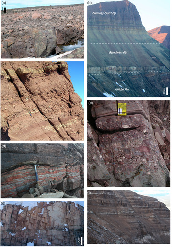
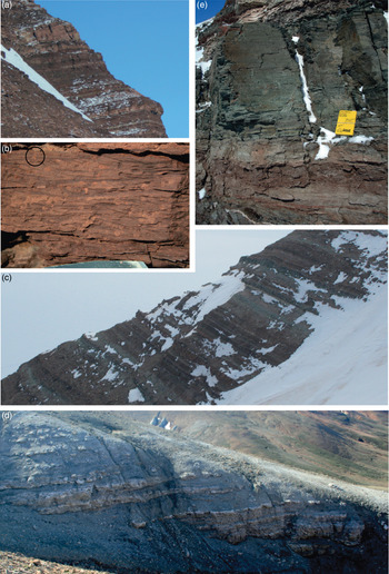
At the eastern basin margin, the Klitdal Formation is broadly flat-lying and, in the region east of Triasdal, on-laps the basement with a discordance of c. 6° (Fig. 4a). Evidence for a more complex faulted margin is presented by Guarnieri et al. (Reference Guarnieri, Brethes and Rasmussen2017) with the development of multiple graben along the eastern margin of the basin. An apparently conformable relationship with the underlying Rødestaken Formation (here placed within the Wordie Creek Group) is recorded in Devondal/Wegner Halvø region. The top of the Klitdal Formation appears conformable with the overlying Gipsdalen Group in the Klitdal and Carlsberg Fjord regions, but an angular unconformity is recognized in the Devondal succession (Fig. 4b), providing direct evidence for a Middle Triassic period of tectonism. A rapid thinning of the Klitdal Formation occurs NW across Devondal, north of which the Klitdal Formation has not been recorded (Fig. 3).
Pingo Dal Group. (a) Onlap of the Klitdal Formation onto fractured Caledonian granite on the east side of Klitdal at the eastern margin of the basin (unconformity marked by the dashed line). (b) Angular unconformity between the Klidal Formation and the overlying Gipsdalen Group. (c) Typical coarse-grained facies of the Klitdal Formation, Nordenskiöld Bjerg. (d) Stage IV pale-grey calcrete and red silcrete development, Devondal south. (e) Coarse-grained facies of the Paradigmabjerg Formation, Snæveggen. (f) Intercalated sandstones, siltstones and mudstones, including distinctive white sugary gypsum sands, of the upper portion of the Paradigmabjerg Formation in eastern Pingo Dal (c. 27 m section). (g) Large-scale cross-bedding, eastern Pingo Dal (Kolledalen Formation).

The Klitdal Formation comprises coarse clastics (Fig. 4c) with subordinate silty sandstones and mudstones that often contain evidence of pedogenesis. These have been interpreted as alluvial fan and fluvial deposits by Clemmensen (Reference Clemmensen1980 b). The presence of mature calcretes and silcretes (Fig. 4e) suggests that extended periods of non-deposition occurred.
Hanging-wall slopes tend to hold larger fans than their footwall counterparts because of their larger catchments and gentler slopes (Gawthorpe & Leeder, Reference Gawthorpe and Leeder2000). This is consistent with the prevalence of coarse-grained facies within the Pingo Dal Group along the eastern basin margin. The initiation of these fans with larger catchments may have resulted in a rapid progression to stage 3 of fan development, as described by Blair & McPherson (Reference Blair and McPherson1994), which is commonly composed of a significant sheetflood component. A predominance of sheetflood process (type II alluvial fan) is further aided by a lack of clay in the catchment, which is commonly the case with granitic and gneissic catchments in arid environments (Blair & McPherson, Reference Blair and McPherson1994). It is likely that such a scenario existed along the eastern margin of the Jameson Land Basin during the Triassic Period.
Palaeocurrent data provide evidence for a radial, broadly westerly directed flow throughout the Klitdal Formation (Clemmensen, Reference Clemmensen1980 b). Such palaeoflow directions are also consistent with the interpretation of the facies described as reflecting laterally draining fan systems mantling the Liverpool Land footwall slope. Models for the evolution of extensional basins predict that, with time, axial drainage systems will develop (Gawthorpe & Leeder, Reference Gawthorpe and Leeder2000). Evidence for axial drainage is limited in the Jameson Land Basin; however, this may not be unexpected as Fordham et al. (Reference Fordham, North, Hartley, Archer and Warwick2010) noted a prevalence of lateral over axial drainage systems in dryland rift basins resulting from limited run-off in such environments. Any axial drainage systems tend to remain small and restricted to a narrow corridor by the progradation of the lateral systems.
3.a.2. Paradigmabjerg Formation
Four sections through the Paradigmabjerg Formation have been examined; Sporfjeld (> 142 m), Kap Seaforth (> 39 m), Snevæggen (474 m) and Pingo Dal (> 275 m) (Fig. 3), which suggests a general thinning from west to east. Similar thicknesses are presented by Clemmensen (Reference Clemmensen1980 a), who also noted a minimum thickness of 150 m at the type locality on Wegener Halvø at Paradigmabjerg. Extensive block faulting in the more westerly Pingo Dal region does not allow measurement of a complete section through the Paradigmabjerg Formation, but a number of thick sequences (up to 600 m on point 800 at the confluence of Gipsdalen and Pingo Dal) have been observed that cannot be correlated and, therefore, may reflect a great thickness in this region.
The base of the Paradigmabjerg Formation has not been observed where well exposed, but in Pingo Dal a distinct change to pebble-rich facies is noted in the scree slopes. Clemmensen (Reference Clemmensen1980 a) noted a more gradual switch from the sandstone-dominated Rødestaken Formation to the coarser conglomerates and arkoses of the Paradigmabjerg Formation. However, Perch-Nielsen et al. (Reference Perch-Nielsen, Birkenmajer, Birkelund and Aellen1974) suggested that a sharp contact is present in the Gurreholm Bjerge in the west, which is more in line with the observations recorded here. Defining the upper boundary is less simple, probably partly because of lateral facies variations.
Clemmensen (Reference Clemmensen1980 a) suggested that the upper boundary of the Paradigmabjerg Formation be placed at the base of the first weakly gypsum-cemented, large-scale cross-bedded buff sandstones of the Kolledalen Formation in the west, and at the base of the first thinly bedded, gypsum-bearing, intercalated mudstones and sandstones in the east. However, in the west (Pingo Dal), thinly bedded gypsum-bearing sequences are recorded beneath the Kolledalen Formation; similarly, in the east (Kap Seaforth), sandstones of a similar character to those of the Kolledalen Formation are recorded overlying more heterolithic deposits.
Since the Kolledalen Formation is more widespread than previously thought, we here place the upper boundary of the Paradigmabjerg Formation at the transition to the dominantly buff, large-scale cross-bedded, well-rounded sandstone facies characteristic of the Kolledalen Formation. The facies of the Kolledalen Formation are discussed in greater detail in the following section.
The Paradigmabjerg Formation displays significant lateral variation in its character. In proximal regions, facies are dominated by coarse clastics (Fig. 4e), interpreted as the deposits of alluvial fans. In medial regions, the Paradigmabjerg Formation forms a fining-upwards succession. The lower portion is characterized by coarse clastics, with the upper part containing an increased proportion of finer-grained facies consisting of intercalated thinly bedded sandstones, siltstones and mudstones (Fig. 4f). The finer-grained facies contain desiccation cracks, bioturbation and gypsum, which are interpreted to reflect deposition in a playa setting with the sandstone elements recording episodes of fluvial deposition. The distal examples of the Paradigmabjerg Formation display a similar fining-upwards motif. Medium- to coarse-grained cross-bedded pebbly sandstones of fluvial origin are succeeded by interbedded rippled and bioturbated red very-fine- to fine-grained sandstones and desiccated mudstones and/or siltstones interpreted as playa deposits.
Broadly eastwards-directed palaeocurrents gained from the fluvial facies in the lower portion of the Paradigmabjerg Formation (Clemmensen, Reference Clemmensen1980 b) indicate the prevalence of lateral over axial drainage, as is common in dryland rift settings. A rapid, proximal to medial, transition from debris-flow-dominated to more fluvial-dominated facies is recognized away from the western-bounding Stauning Alper Fault, with the distal portions of these systems comprising sandstones of a dominantly fluvial origin intercalated with lacustrine units. The scale of these lateral systems (> 60 km) is consistent with a distributive fluvial system model, with the coarser clastic components being confined to the faulted western margin where more debris-flow processes predominated. The finer-grained nature of the upper portion of the succession in the medial and distal regions of the basin may reflect rejuvenation of faulting along the western margin of the basin leading to the confinement of coarse clastics to the west (Fordham et al. Reference Fordham, North, Hartley, Archer and Warwick2010; Gawthorpe & Leeder, Reference Gawthorpe and Leeder2000). The occurrence of gypsiferous lacustrine facies in the upper portion of the Paradigmabjerg Formation towards the west of the basin is consistent with a westwards shift in depocentre, which would be expected with tectonic rejuvenation.
3.a.3. Kolledalen Formation
Sections through the Kolledalen Formation have been examined in Pingo Dal (209.3 m), Snevæggen (142 m) and Kap Seaforth (71 m), indicating its wide distribution. Clemmensen (Reference Clemmensen1980 a) defined the Kolledalen Formation as lying at the base of the Gipsdalen Group, and suggested that it was confined to the western margin of the basin. New localities visited and re-assessment of those localities figured by Clemmensen (Reference Clemmensen1980 a, b) have shown that Kolledalen Formation facies reach as far east as Kap Seaforth, although a thinning to the south is recorded and no correlative occurs south of Devondal. Given the arenaceous nature of the Kolledalen Formation, it is here included in the Pingo Dal Group rather than the overlying predominantly argillaceous Gipsdalen Group.
The base of the Kolledalen Formation is defined as the first occurrence of buff to yellow well-sorted sandstones, often containing large-scale cross-bedding and further indications of deposition in an aeolian setting as described in the following. The top of the Kolledalen Formation is marked by the transition to the predominantly argillaceous, red, fluvio-lacustrine Solfaldsdal Formation. Often this transition is abrupt, especially where the Kolledalen Formation is directly overlain by the dark-grey mudstones of the Gråklint Member.
The Kolledalen Formation comprises large-scale cross-bedded buff sandstones (Fig. 4g), thin-bedded buff sandstones variably intercalated with grey-green mudstones, pebbly buff sandstones and conglomerates, and dark-grey to black mudstones that are interpreted as the deposits of an aeolian system with associated fluvial and interdune elements. The absence of pebbles and the textural maturity of the sandstones containing the large-scale cross-bedding provide further evidence for their aeolian origin.
Clemmensen (Reference Clemmensen1978 a) recorded extensive palaeocurrent data from throughout the Kolledalen Formation and demonstrated a broadly north to northeasterly palaeowind, consistent with a position within the NE trade wind belt. Clemmensen (Reference Clemmensen1978 a) also suggested that the distribution of palaeocurrent data was typical of barchanoid dune forms, following the work of Glennie (Reference Glennie1970). Barchanoid dunes reflect relatively low sediment supply conditions (Wasson & Hyde, Reference Wasson and Hyde1983; Rubin, Reference Rubin1984) and, combined with the evidence for regularly damp conditions (grey green mudstones), suggest that deposition of the Kolledalen Formation reflects a wet dune system, similar to the Triassic and Permian examples described by Mountney & Thompson (Reference Mountney and Thompson2002) and Mountney & Jagger (Reference Mountney and Jagger2004). A greater abundance of facies reflecting large-scale dune development are recorded to the west, with interdune and sandsheet facies more prevalent in the eastern regions. This could be explained by the reduction in wind strength related to the proximity of a topographic barrier (mountainous terrain to the west of the basin-bounding fault), as has been proposed as a major control on sand-sea development by Fryberger & Ahlbrandt (Reference Fryberger and Ahlbrandt1979).
3.a.4. Implications for basin development
A broadly east–west thickening is recorded in the Pingo Dal Group across the Jameson Land Basin, suggestive of a half-graben basin geometry with active faulting occurring along the western margin. The eastern margin succession comprises extensive alluvial fan and fluvial sediments, the Klitdal Formation, which onlap the basement with 6° of angular discordance (Fig. 4a). The development of extensive alluvial fan systems is typical of footwall slopes where potentially larger catchments and gentler gradients occur (Gawthorpe & Leeder, Reference Gawthorpe and Leeder2000). However, it should be noted that subsurface data suggest that, alongside the onlap features noted here, significant faulting also occurred along the eastern basin margin (Guarnieri et al. Reference Guarnieri, Brethes and Rasmussen2017). The Stauning Alper Fault forms the putative western bounding margin of the basin, towards which the Pingo Dal Group thickens, but the lack of good exposure limits our understanding of the character of this fault during the Triassic Period. The base of the Pingo Dal Group in this region is recognized on the basis of the introduction of pebbly sandstones that overlie the sand-dominated Rødestaken Formation and are suggestive of tectonic rejuvenation at this time. The finer-grained nature of the Paradigmabjerg Formation (the western correlative of the Klitdal Formation) is typical of a more axial position within a half-graben setting where the progradation of coarse alluvial systems is restricted because of activity on the basin-bounding fault. An upwards fining in the Paradigmabjerg Formation in the medial and distal regions may reflect degradation of the footwall or, alternatively, renewed fault activity resulting in further recession and confinement of coarser clastics towards the basin margin fault.
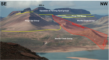
Thickness variations in the Pingo Dal Group have highlighted the presence of an intrabasinal high in the Devondal region, which provides evidence for the division of the Jameson Land Basin into at least two sub-basins. The Pingo Dal Group thickens into the NE–SW-oriented Devondal Fault (Fig. 5). No clear expression of this structural feature is recognized in the overlying strata, although an unconformity is developed prior to the deposition of the Solfaldsdal Formation (Gråklint Member). The orientation of the Devondal Fault is at nearly 90° to the faulting pattern inferred from seismic data by Dam et al. (Reference Dam, Surlyk, Mathiesen, Christiansen, Steel, Felt, Johannessen and Mathieu1995) for the Late Triassic Kap Stewart Group, reflecting a gradual NE–SW thickening in the Kap Stewart Group. However, the recent work of Guarnieri et al. (Reference Guarnieri, Brethes and Rasmussen2017) and Brethes et al. (Reference Brethes, Guarnieri, Rasmussen and Bauer2018), based on localized fieldwork, remote sensing techniques and subsurface data, has recognized a suite of faults with broadly NE–SW alignments, consistent with the Devondal Fault described here.
View SW up Devondal from the northern slopes of Nordenskiöld Bjerg. There is a distinct SE–NW thinning of the Pingo Dal Group across the inferred fault trace of the Devondal Fault. No evidence is recognized for activity on this fault during the deposition of the post-Carnian succession.

3.b. Gipsdalen Group
The Gipsdalen Group comprises the heterolithic Solfaldsdal and Kap Seaforth formations. The Solfaldsdal Formation contains the regionally correlatable Gråklint Member that in many instances marks the base of the Gipsdalen Group (Fig. 3). Outcrops of the Solfadsdal and Kap Seaforth formations are often subject to intense weathering as a consequence of their argillaceous nature; it can therefore be problematic to identify the boundary between these two formations.
The age of the base of the Gipsdalen Group is relatively well constrained as middle Carnian by the palynological assemblage recorded from the Gråklint Member (Andrews et al. Reference Andrews, Kelly, Braham and Kaye2014).
3.b.1. Solfaldsdal Formation
Sections through the Solfaldsdal Formation have been examined at eight localities: Pingo Dal central (130.8 m), Pingo Dal east (91.6 m), Kap Seaforth (98 m), Sporfjeld (147 m) and MacKnight Bjerg (> 50 m) (Fig. 3). The exposure in a number of localities did not allow accurate differentiation from the Kap Seaforth Formation, so a total thickness for the Gipsdalen Group was measured at Devondal south (107.8 m), Carlsberg Fjord (87 m) and Snevæggen (44.5 m). At the base of the Solfaldsdal Formation, the Gråklint Member form an important regionally correlatable unit through which numerous sections have been examined: Pingo Dal east (8.3 m), Snevæggen (3.5 m), Kap Seaforth (43 m), Sporfjeld (54 m), Gråklint (> 13 m), Pingel Dal (10 m), Devondal north (9 m), Devondal south (12 m), Carlsberg fjord (four sections averaging 10 m) and Wood Bjerg (> 4.7 m).
The base of the Solfaldsdal Formation shows significant lateral variance in its character, resulting in a complex lower boundary. In the west (Pingo Dal) the boundary is placed where the well-sorted buff sandstones of the Kolledalen Formation are overlain by gypsum-bearing red mudstones, siltstones and sandstones characteristic of the Solfaldsdal Formation. Throughout the rest of the basin the lower boundary of the Solfaldsdal Formation coincides with the base of the Gråklint Member, which variably overlies the Paradigmabjerg Formation, the Klitdal Formation and the areally restricted Kolledalen Formation (Fig. 3). In Devondal the contact is marked by a locally developed unconformity with the underlying Klitdal Formation (Fig. 4b).
The upper boundary of the Gråklint Member is universally marked by the appearance of red mudstones, siltstones and sandstones, often containing abundant bioturbation, typical of the Solfaldsdal Formation, which contrast markedly with the dark mudstones and buff/grey sandstones of the Gråklint Member. The upper boundary of the Solfaldsdal Formation is marked by the appearance of grey mudstones and siltstones, indicative of the variegated Kap Seaforth Formation.
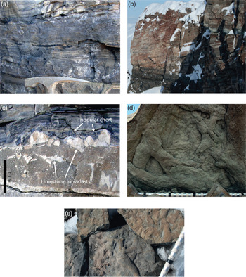
The Gråklint Member, which commonly forms the base of the Solfaldsdal Formation, comprise black to dark-grey mudstones and limestones (Fig. 6a); grey to light-grey mudstones, siltstones and limestones; cross-bedded grey calcareous sandstones (Fig. 6b); and, of very restricted occurrence, sandy limestone breccias (Fig. 6c). These facies are described fully by Andrews et al. (Reference Andrews, Kelly, Braham and Kaye2014).
Gråklint Member. (a) Finely laminated black calcareous bituminous mudstones, characteristic of the Gråklint Member, Nordenskiöld Bjerg. (b) Large-scale cross-bedding (3.5 m) in sandy limestones, the NW ridge of Point 850, Pingel Dal. (c) Sandy limestone breccia facies with black chert nodules, after Magadiite, draped by the overlying black mudstones, Nordenskiöld Bjerg. (d) Cruziana-type traces and branching. (e) Thalassinoides?-type burrows on bed bases from Kap Seaforth.

The Gråklint Member was first described, as the Myalina limestone, by Grasmück & Trümpy (Reference Grasmück and Trümpy1969), who regarded the interval to reflect a marine ingression on the basis of its wide extent and the presence of a marine fauna. This interpretation was followed by Perch-Nielsen et al. (Reference Perch-Nielsen, Birkenmajer, Birkelund and Aellen1974) and Clemmensen (Reference Clemmensen1980 a), who suggested that the complex facies pattern was characteristic of a marine setting with beach barriers isolating lagoonal regions. The differentiation of marine from lacustrine settings is problematic where good palaeontological control is absent. The general paucity of fossil material and, where present, the high-abundance and/or low-diversity assemblages, suggest a predominantly non-marine setting (Andrews et al. Reference Andrews, Kelly, Braham and Kaye2014). Andrews et al. (Reference Andrews, Kelly, Braham and Kaye2014) favoured a largely lacustrine interpretation of the predominantly black to dark-grey mudstones and limestones of the southern outcrops of the Gråklint Member that were barred (large-scale cross-bedded grey calcareous sandstones) from a greater marine influence that lay to the north. Intermittent marine flooding events were recorded, accounting for limited marine fauna and the development of Magadi-type cherts (sandy limestone breccias). A northwards increase in the diversity in trace fossils (Fig. 6d, e) and in the fauna itself, including the marine bivalve Halobia sp., is consistent with the identification of marine Triassic strata of a similar age on Traill Ø and Geographical Society Ø (Andrews & Decou, Reference Andrews and Decou2018).
The main body of the Solfaldsdal Formation comprises red desiccated mudstones, siltstones and rippled sandstones (Fig. 7a), all of which contain abundant monospecific bioturbation (Fig. 7b). Minor gypsum and halite pseudomorphs are also recorded. These features are consistent with a playa depositional setting with minor fluvial input.
(a, b) Solfaldsdal and (c–e) Kap Seaforth formations. (a) Interbedded red mudstones, siltstones and sandstones, typical of the Solfaldsdal Formation corpus, Sporfjeld (thickness of strata c. 50 m). (b) Bioturbation (BI 2) starting to obscure original ripple structures; miniscate fill indicating downwards burrowing can be recognized in a burrow towards the top left (circled). (c) Characteristic variegated appearance of the Kap Seaforth Formation mudstones, siltstones and sandstones, Kap Seaforth (30 m). (d) Thick, stacked, massive gypsum beds in Dværgarvedal. (e) Well-laminated grey mudstones, with this sandstone laminae forming the deepest water portion of a lacustrine cycle in a basin centre position, Sporfjeld.

3.b.2. Kap Seaforth Formation
Sections through the Kap Seaforth Formation, which forms the uppermost unit of the Gipsdalen Group, have been examined at MacKnight Bjerg (> 23 m), Kap Seaforth (> 69 m), Sporfjeld (112 m) and Pingo Dal (101 m). The argillaceous nature of the Kap Seaforth Formation contributes to its commonly intensely weathered appearance, causing problems in locating the boundary with the underlying Solfaldsdal Formation. A number of sections have therefore been examined where the thickness of the individual formations comprising the Gipsdalen Group is not possible (Devondal south, Carlsberg Fjord, Snevæggen).
Where exposure allows its identification, the lower boundary of the Kap Seaforth Formation is marked by the appearance of grey mudstones and siltstones (1.0–1.5 m thick) that leads to its characteristic variegated appearance (Fig. 7c). The upper contact is commonly clearly defined due to the cliff-forming nature of the overlying buff/yellow dolomitic mudstones of the Edderfugledal Formation, which contrast clearly with the red and grey gypsiferous sandstones and mudstones of the Kap Seaforth Formation.
The Kap Seaforth Formation consists of intercalated red and grey mudstones and rippled sandstones. Abundant bedding-parallel and nodular gypsum has caused considerable disruption that, in some instances, has resulted in homogenization of mudstone and sandstone components. Significant lateral variability in the abundance of gypsum is recorded with some sections containing stacked beds of gypsum up to 2 m thick (Fig. 7d). Towards the eastern basin margin, sandstone units are more commonly intercalated with well-defined gypsum developments including a subordinate mudstone component (Fig. 7e). The Kap Seaforth Formation is interpreted as reflecting a highly evaporative, saline, playa environment, with regular alternations between coarser- and finer-grained units recording cyclic variations in playa level.
The lateral variability in the abundance and character of the gypsum deposits likely reflects subtle variations in the basin floor topography and, therefore, the presence of multiple, isolated, brine pools. This also seems to be reflected in the variable thickness of this unit across the basin (Fig. 3).
Lateral variability in the cycles, from sand dominated in the west to mud-rich and heavily gypsum-disrupted facies in central regions, is recognized. The sand-rich nature of cycles in the west, including cross-bedded sandstones of aeolian character, are likely to result from proximity to the western basin margin from which, by this time, the majority of sediment was likely being derived (see provenance data in Section 4). The variable thickness of the mud- and gypsum-dominated deposits of the more central regions is consistent with the presence of continued basin topography resulting in the development of multiple smaller lakes during lowstand conditions. These are likely to have varied in chemistry and, therefore, the extent to which evaporites will have formed.
3.b.3. Implications for basin development
As a whole the Gipsdalen Group displays a subtle westwards thickening (from > 73 m to 261.3 m; Fig. 3) suggesting continued, but reduced magnitude, faulting along the western margin of the basin. Evidence for tectonism immediately preceding the onset of deposition of the Gipsdalen Group is indicated by the presence of a locally developed unconformity beneath the Gråklint Member in the Devondal region. The Solfaldsdal and Kap Seaforth formations, however, have a much more tabular appearance than the underlying Pingo Dal Group (Fig. 3); it is therefore suggested that topography was relatively subdued by this time. The transition to the finer-grained Gipsdalen Group from the underlying Pingo Dal Group supports this assertion; furthermore, it can be suggested that relief in the source area was diminished, reducing the input of coarse clastic material. Similar fining-upwards successions are recorded in Triassic basins spanning the North Atlantic to the south (Leleu & Hartley, Reference Leleu and Hartley2010). This has been attributed to decreasing source area relief and aggradation within the basin reducing average gradient and, therefore, transport capacity during rift evolution.
Distinct lateral sedimentological variability is recorded in the Gråklint Member, illustrating the control exerted by the Devondal high at this time, north of which a pronounced thickening of the Gråklint Member occurs and an intermittent marine influence is recognized. A more subtle variability is recognized within the main body of the Solfaldsdal Formation and the Kap Seaforth Formation with a transition from largely sand-rich successions in the west to a more mud-dominated succession in the central regions of the basin. The sandier nature of the western successions reflects the proximity to the western basin margin from which, by this time, it is likely that the majority of coarse clastic sediment was being derived.
The revised biostratigraphic constraints provided by Andrews et al. (Reference Andrews, Kelly, Braham and Kaye2014) allow the Triassic succession to be considered within a wider regional context. The marine influence recognized within the Gråklint Member can therefore be correlated with the marked middle–late Carnian global sea-level highstand (Fig. 2) (Haq et al. Reference Haq, Hardenbol and Vail1987; Golonka & Ford, Reference Golonka and Ford2000). The restricted marine salts reported from the Triassic strata of the Halten Bank (Jacobsen & van Veen, Reference Jacobsen, van Veen, Spencer, Holter, Johnsen, Mork, Nysether, Songstad and Spinnangr1984; Müller et al. Reference Müller, Nystuen, Eide, Lie, Wandås, Nystuen, Eide and Gradstein2005) and the marine Triassic strata recorded in Traill Ø and Geographical Society Ø (Andrews & Decou, Reference Andrews and Decou2018) provide further evidence for southerly marine incursions from the Boreal ocean at this time.
An upwards increase in the abundance of gypsum and halite pseudomorphs through the Gipsdalen Group, from the Solfaldsdal Formation to the Kap Seaforth Formation, suggests a general trend towards more arid conditions. When compared with climatic curves constructed for the Triassic Southern Permian Basin and Barents Shelf (McKie, 2014), it is suggested that this can be correlated with the late Carnian – early Norian aridification.
3.c. Fleming Fjord Group
The Fleming Fjord Group forms the uppermost unit of the Triassic succession in the Jameson Land Basin (Fig. 2) and comprises the Edderfugledal, Malmros Klint and Ørsted Dal formations (Clemmensen, Reference Clemmensen1980 a; Clemmensen et al. Reference Clemmensen, Kent, Mau, Mateus and Milàn2020). The Edderfugledal Formation is split into the lower, microbialite-rich Sporfjeld Member, and the overlying sandier Pingel Dal Member (Clemmensen, Reference Clemmensen1980 a; Clemmensen et al. Reference Clemmensen, Kent, Mau, Mateus and Milàn2020). The varied lithological character of the Ørsted Dal Formation has also resulted in its subdivision into the arenaceous Bjergkronerne Member, the argillaceous Carlsberg Fjord Member (Jenkins et al. Reference Jenkins, Shubin, Amaral, Gatesy, Schaff, Clemmensen, Downs, Davidson, Bonde and Osbæck1994) and the carbonate-rich Tait Bjerg Member (Clemmensen, Reference Clemmensen1980 a; Clemmensen et al. Reference Clemmensen, Kent, Mau, Mateus and Milàn2020). In this study, continuity between the Carlsberg Fjord Member and the Tait Bjerg Member is recognized; these units are therefore combined as the Carlsberg Fjord Member.
3.c.1. Edderfugledal Formation
The Edderfugledal Formation is a prominent cliff-forming unit; as a result, its base is often scree covered and the upper contact with the overlying Malmros Klint Formation is often inaccessible, making measurement of the complete succession difficult. Sections through the Edderfugledal Formation have been examined across the Jameson Land Basin (MacKnight Bjerg (> 55 m), Carlsberg Fjord (> 30 m), Devondal (> 30 m), Kap Biot (> 16.5 m), Sporfjeld (69 m), Malmros Klint (> 31 m), Snevæggen (51.5 m) and Pingo Dal (55.7 m). Thicknesses are remarkably consistent across the basin, varying between 51.5 and 69 m where the complete succession was exposed.
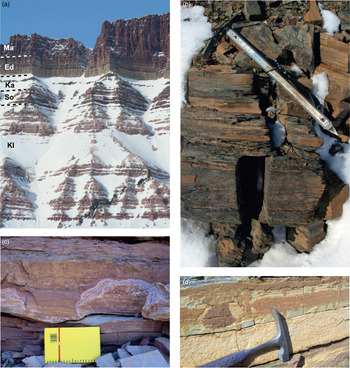
The base of the Edderfugledal Formation is easily recognized by the sharp transition from the more friable grey, gypsum-bearing mudstones and sandstones of the underlying Kap Seaforth Formation to the buff to yellow weathering of the dolomitic mudstones, characteristic of the Edderfugledal Formation (Fig. 8a). The contact between the component Sporfjeld and overlying Pingel Dal members is marked by the appearance of prominent wave-rippled grey sandstone units up to 4 m thick that characterize the Pingel Dal Member. A gradational contact with the overlying Malmros Klint Formation is recognized and a variegated colouration is recognized. The top of the uppermost grey hummocky cross-stratified sandstone or microbialitic limestone indicates the upper boundary of the Edderfugledal Formation (Clemmensen, Reference Clemmensen1980 a).
Edderfugledal Formation. (a) The prominent buff/yellow-coloured cliff forming Edderfugledal Formation, c. 40 m thick, on Buch Bjerg (Kl – Klitdal Formation; So – Solfaldsdal Formation; Ka – Kap Seaforth Formation; Ed – Edderfugledal Formation; Ma – Malmros Klint Formation). (b) Laminated grey mudstones within the Edderfugledal Formation at Malmros Klint. (c) Microbialites from the Sporfjeld Member that form the base of the Edderfugledal Formation, Tait Bjerg, displaying ridge and runnel features. (d) Typical buff-coloured desiccated mudstone facies of the Edderfugledal Formation, Tait Bjerg.

The Edderfugledal Formation has a characteristic buff colouration, indicative of its predominantly dolomitic composition, and comprises (in well-defined cycles): laminated dark-grey mudstones (Fig. 8b); intercalated grey mudstones/siltstones and sandstones: microbialitic carbonates (Fig. 8c); desiccated mudstones (Fig. 8d); and grey hummocky cross-stratified sandstones and nodular/brecciated grey-buff dolostones. Broad-scale facies variations across the basin are remarkably limited, but microbialite abundance tends to diminish towards the NW. The cycles are interpreted as lacustrine in origin, recording deposition in a carbonate-rich evaporative lake system where lake level and lake chemistry were controlled by climatic fluctuations (Clemmensen, Reference Clemmensen1978 b).
The dominance of carbonate within the Edderfugledal Formation is indicative of arid conditions (Kelts & Hsü, Reference Kelts, Hsü and Lerman1978; Muir et al. Reference Muir, Lock, Von Der Borch, Zenger, Dunham, Ethington, Zenger, Dunham and Ethington1980) and also relatively low clastic input. This is particularly true for the development of microbialitic limestones and, as such, it is suggested that relief within the basin and its catchments had become much reduced during the deposition of the Edderfugledal Formation.
3.c.2. Malmros Klint Formation
The Malmros Klint Formation is often subject to intense weathering, resulting in poor exposure or steep inaccessible cliffs (Fig. 8a). Sections, often only the lowermost portions, have been examined at Carlsberg Fjord (> 270 m), MacKnight Bjerg (> 30 m), Kap Biot (222 m), Snevæggen (> 20 m), Malmros Klint (> 13 m) and Pingo Dal central (> 188 m) with observations made where exposure allows. A general thinning of the Malmors Klint Formation occurs to the west and SW. This thinning is inversely mirrored by the thickening of the overlying Ørsted Dal Formation, suggesting that this contact is diachronous with the progradation of the Ørsted Dal Formation sands from the NW while the Malmros Klint Formation playa systems still existed in the SE. This is discussed further in the context of the Ørsted Dal Formation in the following section.
The base of the Malmros Klint Formation can commonly be recognized by the change from the variegated nature of the Edderfugledal Formation to the distinctive red colouration of the Malmros Klint Formation. The upper contact with the overlying Ørsted Dal Formation is placed below the first occurrence of coarse buff-grey sandstone beds (Bergkronerne Member), or the occurrence of the more variegated (purple, red, grey) argillaceous deposits of the Carlsberg Fjord Member.
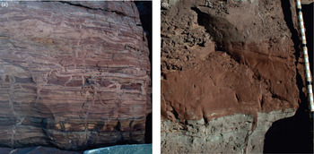
The Malmros Klint Formation comprises brecciated calcareous mudstones, intercalated sandstones and desiccated mudstones, and massive red mudstones (Fig. 9a, b). These are interpreted as the deposits of an argillaceous playa lake where periods of repeated desiccation led to the generation of brecciated and massive mudstones. As in the underlying units, lake level was subject to climatically modulated fluctuations, resulting in a cyclic arrangement of lithologies (Clemmensen et al. Reference Clemmensen, Kent and Jenkins1998).
Malmros Klint Formation. (a) Intercalated rippled sandstones and desiccated mudstones indicative of a playa setting, Malmros Klint Formation (Malmros Klint). (b) Massive red mudstone facies of the Malmros Klint Formation (lower Dværgarvedal).

3.c.3 Ørsted Dal Formation
The Ørsted Dal Formation varies in character across the basin. Clemmensen et al. (Reference Clemmensen, Kent, Mau, Mateus and Milàn2020), following the informal definitions of Jenkins et al. (Reference Jenkins, Shubin, Amaral, Gatesy, Schaff, Clemmensen, Downs, Davidson, Bonde and Osbæck1994), divided the Ørsted Dal Formation into the sand-rich Bjergkronerne Member and the more argillaceous Carlsberg Fjord Member. The Tait Bjerg Member, defined by Clemmensen et al. (Reference Clemmensen, Kent, Mau, Mateus and Milàn2020), forms a carbonate-rich unit that is only found towards the basin centre. Where encountered during this study, this unit is problematic to distinguish from the Carlsberg Fjord Member, with which it normally has an extended gradation contact and in fact resembles more of an additional facies rather than a distinct unit. The Tait Bjerg Member is therefore combined with the Carlsberg Fjord Member here.
The Bjergkronerne Member is prevalent in the western and central areas of the basin, where it reaches its maximum thickness of 170 m (Dværgarvedal, where they are underlain by 40 m of the Carlsberg Fjord Member). The Carlsberg Fjord Member thickens eastwards and completely replaces the Bjergkronerne Member, reaching a thickness of 85–115 m (Clemmensen et al. Reference Clemmensen, Kent and Jenkins1998). When considered separately, significant lateral variations in thickness are apparent. However, when considered alongside the Malmros Klint Formation (Fig. 3) each unit compensates for the change in thickness in the other unit, suggesting that the boundary between them is strongly diachronous and appears to reflect lateral facies changes.
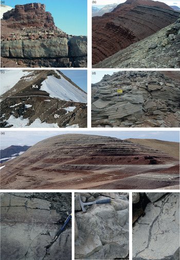
Ascertaining the thickness of the Ørsted Dal Formation is often problematic; firstly, as where present, it often forms the top of mountains, and secondly, it is overlain by the largely Jurassic Kap Stewart Group that comprises coarse sandstones of a similar nature to those of the Bjergkronerne Member. This also causes problems in producing a robust definition for the unit boundaries. The base of the Ørsted Dal Formation (Bergkronerne Member) is defined by Clemmensen (Reference Clemmensen1980 a) as the first appearance of coarse grey sandstone beds, which are initially interbedded with facies similar to those described from the Malmros Klint Formation (Fig. 10a). Where the base of the Ørsted Dal Formation is formed by the Carlsberg Fjord Member, the contact is marked by the change to more variegated (purple, red and grey) facies (Fig. 10b). Clemmensen et al. (Reference Clemmensen, Kent, Mau, Mateus and Milàn2020) note that a relatively thick fluvial sandstone marks the base of the Carlsberg Fjord Member but this seems to only be of localised occurrence.
Ørsted Dal Formation. (a) Coarse grey-buff sandstones that typify the gradational base of the Ørsted Dal Formation (Bergkronerne Member). (b) The more subtle contact between the Malmros Klint Formation and the purple/variegated Carlsberg Fjord Member. (c) Detail of the contact between the Ørsted Dal Formation and the Kap Stewart Group from Kap Biot; locally overturned strata (dashed lines) of the Ørsted Dal Formation overlain by black shales of the Kap Stewart Group. The contact surface is iron stained and littered with coprolites, bone fragments and iron-rich nodules. (d) Cross-bedded coarse sandstones typical of the Bergkronerne Member exposed on the north side of Dværgarvedal. (e) Multi-coloured mudstones of the Carlsberg Fjord Member with thin fine sandstone intercalations forming benches towards the summit of ‘track mountain’. (f) Brecciated limestone facies illustrating brittle brecciation towards the bed top and vertical burrows to the right of the pencil. A mottled texture can also be made out towards the bottom of the bed. (g) Sub-vertical slickensides developed in a massive limestone facies. (h) Rootlets in the brecciated limestone facies.

The upper contact of the Ørsted Dal Formation is complex. Dam & Surlyk (Reference Dam, Surlyk, Posamentier, Summerhayes, Haq and Allen1993) noted unconformable relationships with the overlying Kap Stewart Group around the basin margins, but apparently conformable relationships towards the basin centre. However, Pedersen & Lund (Reference Pedersen and Lund1980) noted the largely poorly exposed nature of the Ørsted Dal Formation – Kap Stewart Group contact in central regions of the basin. Where examined at Kap Biot and in southern Pingo Dal, evidence for a significant hiatus is recognized. A planar but uneven iron stained surface containing carbonate nodules is recognized in Pingo Dal, and a similar surface littered with coprolites and reptile bones, alongside ironstone nodules, is identified at Kap Biot (Fig. 10c). Similar features, characteristic of a condensed sequence were identified in the Fleming Fjord region by Grasmück & Trümpy (Reference Grasmück and Trümpy1969). If a significant hiatus exists, then more realistic sedimentation rates may be calculated for the Gipsdalen and Fleming Fjord groups.
Towards the basin centre the black mudstones of the Rhætelv Formation (Kap Stewart Group) overlie the characteristic limestones and mudstones of the Ørsted Dal Formation (Carlsberg Fjord Member). Here the boundary is defined, most closely following that of Perch-Nielsen et al. (Reference Perch-Nielsen, Birkenmajer, Birkelund and Aellen1974), as the topmost limestone intercalation prior to the onset of black mudstone and associated lacustrine and fluvial sandstone deposition. Care must be taken due to the gradational nature of this contact with black mudstones occurring within the limestones of the Ørsted Dal Formation, and rare limestone intercalations recorded within the black mudstones and associated lacustrine and fluvial sandstones of the Rhætelv Formation.
The definition of this boundary towards the basin margin is more problematic. The Ørsted Dal Formation (Bergkronerne Member) and the Kap Stewart Group (Innakajik Formation) are both of a sandier nature in these regions; furthermore, exposure is often poor. However, the boundary is marked by a transition from buff to drab-coloured sandstones. If exposure allows, the switch from red to black mudstones can also be used to ascertain the position of this boundary.
The Bergkronerne Member comprises predominantly coarse-grained buff-coloured cross-bedded sandstones and subordinate laminated red mudstones with occasional desiccation horizons (Fig. 10a, d). These are interpreted as fluvial deposits. The Carlsberg Fjord Member is dominated by red, purple and greenish mudstones with rarer thin fine-grained sandstone intercalations (Fig. 10e). Massive grey limestones, often containing rootlets, desiccation and slickensides, are recorded towards the basin centre (Fig. 10f–h). These facies are similar to those found in the Malmros Klint Formation and are similarly interpreted as playa deposits. Clemmensen et al. (Reference Clemmensen, Kent and Jenkins1998) recognized persistent cyclicity within the Carlsberg Fjord Member, which they attributed to climatic forcing of lake levels and/or water availability. The presence of rooted and disturbed and/or pedified limestones is suggestive of palustrine conditions forming towards the basin centre.
3.c.4. Implications for basin development
The component formations of the Fleming Fjord Group have broadly tabular geometries, in contrast to the significant lateral thickness variations recognized in the Pingo Dal Group (Fig. 3). The Edderfugledal Formation shows very little lateral thickness variation. Clemmensen (Reference Clemmensen1980 a) suggested a northwards and westwards thinning of the Malmros Klint Formation. However, it should also be noted that the overlying Ørsted Dal Formation thickens to the NW, to some extent balancing the thicknesses and suggesting a diachronous base to the Ørsted Dal Formation. The broadly tabular nature of the Fleming Fjord Group is interpreted to reflect reduced fault activity and a predominance of thermal subsidence across the basin.
Reduced microbialite development towards the NW within the Edderfugledal Formation and the coarse-grained nature of the Bjergkronerne Member, the western component of the Ørsted Dal Formation, suggest that sediment supply was largely from the NW during the deposition of the Fleming Fjord Group. Within the Ørsted Dal Formation, flow from the NW and the SE is recorded (Clemmensen, Reference Clemmensen1980 b), although the latter was recorded in the Carlsberg Fjord region and, therefore, likely derived from finer-grained lacustrine facies. The marked increase in the thickness of the Bergkronerne Member towards the NW would suggest that this system was predominantly sourced from that direction. The mud-dominated nature of the Carlsberg Fjord Member with only minor fine sand input (Clemmensen et al. Reference Clemmensen, Kent and Jenkins1998) suggests that the Liverpool Land high had subdued relief at this time. The influx of coarse clastics from the west has previously been interpreted as indicative of tectonic rejuvenation of the source area (Clemmensen, Reference Clemmensen1980 b; Surlyk, Reference Surlyk, Hardman and Brooks1990), but there is little direct evidence for tectonic activity at this time; instead, climate may have played a role.
The transition from the underlying gypsiferous Kap Seaforth Formation of the Gipsdalen Group to the carbonate-rich Edderfugledal Formation is interpreted to reflect amelioration in climatic conditions, but the abundance of dolomite indicates a continuance of evaporative (Kelts & Hsü, Reference Kelts, Hsü and Lerman1978; Muir et al. Reference Muir, Lock, Von Der Borch, Zenger, Dunham, Ethington, Zenger, Dunham and Ethington1980), if less arid, lacustrine conditions. The reduced abundance of carbonate-rich facies into the Malmros Klint Formation and the overlying Ørsted Dal Formation is interpreted as a continued shift towards more temperate climatic conditions. The increased sediment supply from the NW recognized in the Ørsted Dal Formation could, therefore, also be explained by the shift towards more humid conditions. However, regular desiccation, indicative of the predominantly playa facies, within the mud-dominated succession of the Malmros Klint Formation and Carlsberg Fjord Member indicates that relatively arid conditions continued within the basin; the influx of clastic sediment from the NW may therefore reflect the initiation of more humid conditions in far-reaching catchments. The overlying, predominantly Jurassic, Kap Stewart Group is interpreted as reflecting a temperate and humid climatic setting. This broad trend is consistent with the clay mineralogy data presented by Decou et al. (Reference Decou, Andrews, Alderton and Morton2016).
4. Provenance analysis
Samples, which were largely arkosic to sub-arkosic (Decou et al. Reference Decou, Andrews, Alderton and Morton2016), were collected in order to provide coverage of all the stratigraphic intervals examined. A total of 60 samples were processed for heavy mineral analysis, 17 of which were also subject to garnet geochemistry. Major variations in mineralogy occur within the samples analysed. Some of these are attributable to diagenetic modification (garnet:zircon index, GZi) and, to a lesser extent, weathering (apatite:tourmaline index, ATi) (e.g. Morton & Hurst, Reference Morton, Hurst, Dunay and Hailwood1995), but differences in rutile:zircon (RuZi) and garnet geochemistry, where available, demonstrate the importance of variations in provenance. These variations occur both on a regional and stratigraphical basis (Fig. 11).
W–E correlation of key examined sections, alongside plots of provenance parameters and garnet compositions, through the Triassic succession of the Jameson Land Basin. See Figure 3 for locations of sections. Inset is a schematic cross-section through the Triassic succession of the Jameson Land Basin that summarizes heavy mineral trends, the orange section with a low-RuZi index (< 20) and the green section with a high-RuZi index (> 30). Within the orange section, an east to west transition from garnets indicative of a metasedimentary source to those of eclogitic and granitic sources is recognized. Provenance-sensitive heavy mineral parameters (ATi, GZi, RuZi, MZi) as defined by Morton & Hallsworth (Reference Morton and Hallsworth1994). Garnet types A, B and C as defined by Morton et al. (Reference Morton, Hallsworth and Chalton2004) and Mange & Morton (Reference Mange, Morton, Mange and Wright2007).

4.a. Pingo Dal Group
Assessment of regional variations is best achieved at lower stratigraphic levels (the Klitdal and Paradigmabjerg formations), since these have the widest distribution of sampled sandstone intervals across the area.
In the lower part of the Klitdal Formation, the sandstones at Klitdal and Carlsberg Fjord on the eastern margin of the basin have low RuZi, and their garnet populations can be matched with the granites, metasediments and migmatites that form the central and northern part of Liverpool Land. Higher in the Klitdal Formation, locally derived sediment is superseded by sand shed from a high-grade metamafic source, as indicated by a change to Type C garnet assemblages and slightly higher RuZi. The metamafic source could be the Liverpool Land Eclogite Terrane, which forms the southernmost part of Liverpool Land, but this would require axial transport of at least 50 km from the south. An alternative source could be the Western Gneiss Region (WGR) of Norway, which was immediately east of Liverpool Land prior to rifting of the NE Atlantic (and which was the former structural location of the allochthonous Liverpool Land Eclogite Terrane). The Klitdal Formation contains palaeocurrent indicators that display a radial distribution and a largely westwards palaeoflow, consistent with a predominantly lateral drainage system. However, evidence for a period of faulting occurring towards the top of the Klitdal Formation (pre-Gråklint Member) may have led to catchment re-organization resulting in an influx of Type C garnets from the south. It is also worth noting that a switch to a more lacustrine-dominated setting occurs at this time.
In the NW, towards Pingo Dal, there is a marked change in mineralogy, with all sandstones having higher RuZi (mostly in the range of 30–60; Fig. 11). These sandstones therefore cannot be matched with a source in Liverpool Land, suggesting they were introduced from the western margin of the basin. Garnet geochemical constraints on their provenance are relatively poor, with data available from only two samples (one from Devondal and one from Pingo Dal). Type B garnets are the most important component at Devondal. These garnets were most probably derived from low–moderate-grade metasediments. The garnet population in the Paradigmabjerg Formation at Pingo Dal is dominated by the Type A component, with subsidiary Type B. Type A garnets normally indicate supply from high-grade (granulite facies) metasediments or charnockites. A source for these garnets is thought to have existed in the Milne Land area of East Greenland (Morton & Chenery, Reference Morton and Chenery2009). The garnet data in conjunction with high RuZi values suggest that the western basin margin supplied most of the sediment to the Paradigmabjerg Formation at Pingo Dal.
4.b. Gipsdalen and Fleming Fjord groups
There is evidence for regional heterogeneity in the provenance of the Gråklint Member. Sandstones at Carlsberg Fjord were derived from metamafic rocks, similar to those supplying the upper part of the Klitdal Formation in Klitdal. Derivation from either the Liverpool Land Eclogite Terrane or the WGR is envisaged. The Gråklint Member at Kap Seaforth and Sporfjeld have similar RuZi but much lower ATi, indicating a different source and/or transport history. Further information on the relationships between the sandstones at these three locations is not available, since garnets are absent from Kap Seaforth and Sporfjeld.
RuZi values in the Solfaldsdal, Kolledalen, Kap Seaforth and Edderfugledal formations are generally moderate to high across the area (Fig. 11), which is consistent with the putative western source that appears to be dominant by this time. The garnet population in a Solfaldsdal Formation sample at Pingo Dal contains approximately 50% Type A and 50% Type B, indicating input from both low–moderate-grade and high-grade metasediments. However, there is a distinct increase in RuZi in the Malmros Klint Formation – Kap Stewart Group interval, and garnet data from the Ørsted Dal Formation suggests this rise in RuZi was associated with an increase in the abundance of Type A garnet (Fig. 11). This trend implies increasing supply from the high-grade rocks in the vicinity of Milne Land, the main source of Type A garnet in this part of East Greenland (Morton & Chenery, Reference Morton and Chenery2009; Morton et al. Reference Morton, Hallsworth, Strogen, Whitham and Fanning2009).
4.c. Climate: ATi
In addition to the variations in RuZi values within the dataset, Figure 11 also demonstrates the variability in ATi. Some of this is likely to reflect present-day weathering, and samples with extremely low ATi are therefore suspect. By discounting very low ATi samples, however, it is apparent that the proportion of samples with low ATi increases up the section, being least common in the Klitdal and Paradigmabjerg formations and most common in the Kap Seaforth – Kap Stewart interval. This pattern implies that weathering during transport, and periods of sediment storage, became more widespread through time, consistent with a trend towards more humid climatic conditions. This conclusion is consistent with that of Decou et al. (Reference Decou, Andrews, Alderton and Morton2016) who looked at trends in clay mineralogy, petrography and heavy minerals and found evidence for an upsection increase in sandstone maturity and kaolinite/illite ratio, which they interpreted as a result of increasingly humid climatic conditions.
5. Discussion and conclusions
Close examination of the Middle–Upper Triassic succession of the Jameson Land Basin has yielded important advances in our understanding of the basin evolution at this time, and has provided a robust framework for future research.
The Pingo Dal Group thins to the east, where it onlaps the Caledonian basement. A less simple relationship has recently been demonstrated by Guarnieri et al. (Reference Guarnieri, Brethes and Rasmussen2017), who identified a more complex arrangement of small-scale faulting in this region. Towards the west, the Pingo Dal Group overlies the Lower Triassic marine Wordie Creek Group and the genetically linked Rødestaken Formation, which is here considered to form part of the former. Significant westwards thickening of the Pingo Dal Group provides evidence for large-scale active faulting along the western margin of the basin, and favours an asymmetry in basin development at this time (Fig. 3). Some complexity is added to the basin configuration as a result of the identification of an intra-basinal high in the Devondal region.
The significant lateral facies variation recorded in the Pingo Dal Group is reflected in its division into the Klitdal, Paradigmabjerg and Kolledalen formations. In the west the coarse alluvial fan conglomerates of the Paradigmabgerg Formation rapidly grade eastwards into fluvial and lacustrine facies, reflecting the confinement of the coarse clastics proximal to the faulted western basin margin. Along the hanging-wall slope of the lesser faulted eastern basin margin, large-scale fans developed as recorded by the Klitdal Formation. Palaeocurrent data indicate that lateral drainage predominated. Provenance data support these interpretations, with distinctly different provenance recognized in the sediments derived from the western and eastern basin margins. The dominantly aeolian Kolledalen Formation is here included within the Pingo Dal Group on the basis of lithological affinity. Facies reflecting large-scale dune forms are concentrated along the western basin margin and may reflect reduced wind strengths related to the proximity of a topographic barrier, resulting in increased aeolian accumulation.
The subtle westwards thickening recorded in the Gipsdalen Group is interpreted to reflect continued, but reduced, magnitude faulting along the western basin margin. Further evidence for tectonism is recorded by the development of a local unconformity in the Devondal region. Significant lateral facies variation in the Gråklint Member suggests that relief within the basin persisted into Gipsdalen Group times, but the Solfaldsdal and Kap Seaforth formations have a distinctly more tabular geometry than the underlying Pingo Dal Group they are therefore interpreted to reflect reduced topography within the basin. Provenance data indicate that the western-source-dominated sedimentation throughout the basin during the deposition of the Gipsdalen and Fleming Fjord groups, consistent with the overall reduction in relief and sediments becoming sourced from deeper within the uplands that lay to the west. Type A garnets also become a more prominent feature, largely derived from the Milne Land region, suggesting the increasing importance of an axial drainage system. A reduction in source area relief is also inferred from the fining-upwards trend between the coarse clastics of the Pingo Dal Group and the finer-grained Gipsdalen Group. Leleu & Hartley (Reference Leleu and Hartley2010) recognized similar fining-upwards successions throughout the Triassic basins of the Central Atlantic region, which they attributed to reduced source relief and a reduction in average catchment gradient through aggradation within the basin, resulting in a reduction of fluvial transport capacity.
The marine influence recognized in the Gråklint Member, which are dated as middle Carnian (Andrews et al. Reference Andrews, Kelly, Braham and Kaye2014), can be correlated with a major global sea-level high recorded throughout Pangea during middle–late Carnian time (Haq et al. Reference Haq, Hardenbol and Vail1987; Golonka & Ford, Reference Golonka and Ford2000). This marine influence has been traced northwards through Traill Ø and Geographical Society Ø towards the Boreal Ocean by Andrews & Decou (Reference Andrews and Decou2018), and can also be recognized in the marine salts and carbonates documented from the offshore Triassic succession of Mid-Norway (Jacobsen & van Veen, Reference Jacobsen, van Veen, Spencer, Holter, Johnsen, Mork, Nysether, Songstad and Spinnangr1984; Müller et al. Reference Müller, Nystuen, Eide, Lie, Wandås, Nystuen, Eide and Gradstein2005). An upwards increase in the abundance of gypsum from the Solfaldsdal to Kap Seaforth Formation suggests a general aridification in climatic conditions through the Gipsdalen Group. Further evidence for increasingly arid conditions is recorded by the upwards decrease in the abundance of bioturbation and the appearance of halite pseudomorphs. The revised dating provided by the biostratigraphic work of Andrews et al. (Reference Andrews, Kelly, Braham and Kaye2014) suggests that this arid spike could correlate with a similar trend recognized from the Triassic strata of the Barents Sea and Southern Permian Basin (McKie, 2014) where, following a brief humid period marking the middle Carnian Pluvial Event, a phase of aridification is recorded prior to a long-term trend towards more humid conditions.
The broadly tabular nature of the Edderfugledal and Malmros Klint formations within the Fleming Fjord Group suggests a change from differential fault-related subsidence to post-rift thermal subsidence. The continued amelioration of arid conditions is also recognized, through the carbonate-rich Edderfugledal Formation to the argillaceous Malmros Klint Formation. The renewed influx of coarse clastics from the west recorded in the overlying Ørtsed Dal Formation is therefore most likely to be climatically driven. The upwards increase in the number of samples with low ATi provides further evidence for increasingly humid climatic conditions. The overlying, predominantly Jurassic, Kap Stewart Group records the continued trend towards more humid conditions related to movement of East Greenland northwards into a more temperate climatic belt. The relationship between the Middle–Upper Triassic succession and the Kap Stewart Group, examined everywhere during this study, appears to provide evidence of a significant hiatus. Dam & Surlyk (Reference Dam, Surlyk, Posamentier, Summerhayes, Haq and Allen1993) suggested that a conformable relationship occurred towards the basin centre, although Pedersen & Lund (Reference Pedersen and Lund1980) noted the contact is poorly exposed in this region. Further and more detailed work is required on this boundary to understand its complex nature.
The relative scarcity of offshore data from the Triassic strata of the North Atlantic means that the onshore exposures of East Greenland are of increased importance to our understanding of the stratigraphic evolution of the region through this period. Similarities with other Atlantic basins can be seen in the gross facies trends, which have been related to rift evolution (Leleu & Hartley, Reference Leleu and Hartley2010) and climatic trends. The identification of regional unconformities is also key in building our understanding of rift development. Early Triassic rifting is recognized widely in the region (Štolfová & Shannon, Reference Štolfová and Shannon2009), but the discovery of a phase of Late Triassic (Carnian) tectonism and unconformity development has not previously been recognized in the North Atlantic. Leleu et al. (Reference Leleu, Hartley, van Oosterhout, Kennan, Ruckwied and Gerdes2016) described Carnian unconformities from the Central Atlantic, and McKie (2014) also recognized Carnian unconformity development in the central North Sea, suggesting that tectonic activity may have been extremely widespread at this time. It would certainly be expected that some expression of this event should be visible in offshore datasets. Štolfová & Shannon (Reference Štolfová and Shannon2009) did record a NW-thickening Lower–Middle Triassic package on the Halten Terrace, which they interpreted as the product of growth faulting. This is overlain by a more tabular Upper Triassic package, therefore resembling the fill of Jameson Land Basin. However, no unconformity was reported between the Middle and Upper Triassic packages. Nonetheless, the similarity in stratigraphic geometries of the Jameson Land Basin and the offshore basins of the conjugate margin confirm its importance as an analogue for poorly explored areas in the North Atlantic region.
Supplementary material
To view supplementary material for this article, please visit https://doi.org/10.1017/S001675682000093X
Acknowledgements
The authors would like to thank the consortium of subscribing oil and gas companies for its financial support to the CASP Norway–Greenland Project. Andrew Newell and an anonymous reviewer are also thanked for their useful comments.
Conflict of interests
None declared.