

The use and production of standardized information to govern territory and society is a distinctive characteristic of the modern state (Lee and Zhang Reference Lee and Zhang2017; Scott Reference Scott1998). Prominent among its tools of “legibility” is the land cadaster, a streamlined register of real estate property that helps control the physical landscape, regulate property, and above all, extract taxes. The first cadastral surveys originated in rulers’ drive to increase the tax yield from land, the primary factor of production and the main source of wealth and status in agrarian societies (D’Arcy and Nistotskaya Reference D’Arcy and Nistotskaya2017; Kain and Baigent Reference Kain and Baigent1992). There is a considerable consensus among scholars that “the driving logic behind the [cadastral] map is to create a manageable and reliable format for taxation” (Scott Reference Scott1998, 36).
Land is a ready target for state efforts to extract revenues because, unlike other assets, it cannot be moved or hidden from authorities. This premise underlies a distinguished research tradition that singles out landowner fear of redistribution as an obstacle to democracy (Acemoglu and Robinson Reference Acemoglu and Robinson2006; Boix Reference Boix2003; Ziblatt Reference Ziblatt2008). The same line of reasoning expects recalcitrant landholder opposition to state efforts to survey, register, map, and measure land property, especially under high inequality. As the primary instrument to render the agrarian landscape “legible” and hence taxable, the land cadaster is at the core of the politics of state building, democracy, and redistribution.
This article offers an alternative account of the development of these two core functions of the modern state across the territory it governs—registering and taxing land property. It argues that under certain circumstances, landowners embrace, rather than resist, registration into state cadastral records, a basic form of legibility. Where the legal system is an important arena of adjudication, landholders facing redistributive threats mounted by political opponents, such as land reform programs, have incentives to enter the state’s purview, as a means to defend property claims.
For rightful owners, registration in the state’s land cadaster adds a layer of legal protection in the face of threat and bolsters demands for state enforcement of property rights. For land grabbers, it can be part of a strategy to legalize current or past confiscation. In all, incorporation into the cadaster helps access state protection, justify private evictions, counter mobilization from below in the legal arena, and overall, block attempts at land reform to redress rural grievances. The key point is that incentives exist for threatened landholders to be seen, listed, noted by the public power— in a word, to be recognized by the state and detected by its registering devices.
Registration, however, is a double-edged sword. As emphasized by the literature, it carries permanent taxpaying responsibilities for landowners and, under high inequality, the risk of heavy redistribution to the poor. Landholders must therefore assess the costs and benefits of inscription into the public cadaster—which is, after all, a record of ownership and assessments of land property in the hands of a potentially tax-hungry state.
This article contends, first, that landholders’ willingness to bear some tax cost increases with the perceived level of threat to property claims, provided that registration can bring potential legal advantages. Who controls the executive and leads land reform projects is crucial. In general, those who stand in opposition to the party in power logically perceive greater vulnerability; therefore, they are more likely to formalize property in the cadaster as a preemptive strategy.
Second, tolerance of registration in state records varies inversely with the actual weight of the tax burden, itself a function of tax regulations and opportunities for evasion. This study focuses on one major mechanism through which propertied interests mitigate the trade-off between inscription in the cadaster and the attendant taxpaying obligations. This consists in having cadastral records themselves misrepresent a second key piece of information: the value of land property.
Because property taxes are levied on the value of land property as registered by the state (i.e., the official fiscal value, different from the actual market value), cadastral assessments directly determine the weight of the fiscal burden. In developing contexts, where cadastral authorities often lack autonomy and administrative capacity, landholders can capture or undermine the assessment process to keep official land values down. In doing so, they assert claims to property rights at minimal tax cost. In the face of threat, landowners work to uphold property rights while restraining the tax state.
Overall, the theoretical argument holds that challenged propertied actors can assert their interests by rendering the state’s vision selective in two respects. First, in who is registered (and thus more likely to be legally recognized as a property owner) and who is overlooked (and thus maintained in a state of informality). Second, in what should be seen and what should not—namely, (some) property holders but not the actual value of their property. In short, landowners’ interest lies in the rise of a “one-eyed” state.
This study provides empirical support for this theory using longitudinal microlevel data from Colombia, coded from previously untapped historical and archival sources. It analyzes changes in both the coverage of cadastral records and tax revenues at the municipal level at two critical moments of the country’s history: the adoption of polarizing land reforms by the Liberal Party during the Liberal Republic (1930–46) and at the beginning of the National Front (1958–74). In both cases, it exploits the fact that Liberal-led reformist episodes were especially threatening to Conservative landholders.
Using a difference-in-differences design, the analysis shows that these Liberal reformist episodes triggered a strategic Conservative reaction in the countryside that durably shaped municipal-level patterns of cadastral coverage and tax extraction. Consistent with landholders’ use of legibility to secure legal protection, registration in cadastral records increased disproportionately in historically Conservative municipalities in response to the redistributive threats mounted by Liberal central governments.
However, this larger broadening of the tax base in Conservative areas did not produce a commensurate larger expansion of land tax revenues in them. In fact, fiscal capacity remained higher in Liberal municipalities. Instead of greater legibility translating into greater taxation, the gap in tax extraction across the partisan divide either remained as large as before the land reforms or widened. Relying on quantitative and qualitative historical evidence, the study attributes this pattern to strategic landholder behavior to maintain property systematically undervalued in cadastral records, so as to evade the tax state while asserting legal property rights.
Such a defensive strategy spawned uneven territorial patterns of legibility and taxation, which conventional theories that expect these two dimensions of state building to go together cannot explain. Land property registration increased disproportionately in regions of Conservative strength, precisely where fiscal capacity stagnated. The map of state capacities thus reflected the underlying partisan divide but varied across dimensions of state activity. In the aggregate, the Colombian state increasingly recognized (some) landowners but remained fiscally weak, while landed interests successfully used the legal system—among other instruments—to block redistributionist attempts.
The theory and findings provide new insight into the mechanics of state building and distributive politics. Standard narratives expect landholders to resist legibility, out of the fear of redistribution, and emphasize rulers’ interest in increasing their tax take as the main driver of its expansion. Here, instead, the study brings attention to demand-side forces in shaping patterns of (il)legibility and taxation, two pillars of modern state building.
In this account, property holders shape the geography of the state across its territory and across domains of state activity simultaneously. They do so by engaging strategically with different state institutions, like tax authorities, land-surveying agencies, or courts, to advance their interests. These interests do not involve rejecting the state altogether. Instead, landholders seek to be “seen” and protected by the state as owners, to “blind” the state to competing property claims, and to minimize their tax contributions. Though this perspective shifts the emphasis away from tax extraction by self-interested rulers as the main engine of political development and state capacity outcomes, it evokes another distinctive tradition of political thought that traces the rise of the state to the defense of property.
Theory: Partial Legibility and Property Rights
At least since Adam Smith observed that “land is a subject which cannot be removed” or hidden ([1776] Reference Smith1981, 848), political economists have argued that landowners are distinctly vulnerable to heavy taxation. Arguments that link agrarian inequality with authoritarianism are premised on the notion that landowners block democracy out of the fear of redistributive measures that would be inescapable, due to the nature of land as a fixed, visible, and hence, readily taxable asset (Ansell and Samuels Reference Ansell and Samuels2014; Boix Reference Boix2003; Ziblatt Reference Ziblatt2008). Because state legibility over land is a precondition for taxation, these influential arguments lead us to expect landowners to nip its development in the bud.
Influential models of state building and contractarian approaches to the state, which work from the assumption of self-interested rulers maximizing extraction (Levi Reference Levi1988; Tilly Reference Tilly1992), produce similar expectations. In this tradition, revenuedriven rulers, as rational, stationary bandits, develop measurement techniques and information systems to increase their tax intake. Society strives to hold back the inherently standardizing and extractive modern state (Scott Reference Scott1998). Some groups escape its grip, fleeing to remote areas and adapting their behavior to remain unseen and hence, ungoverned (Scott Reference Scott2009). Over the long run, captive taxpayers who lack an exit option negotiate compensation in the form of rights and public goods (Levi Reference Levi1988; Tilly 2007). Any given landholder, however, would rationally prefer to freeride and elude the state’s sight.
The state’s “crowning artifact” to develop legibility over land is the modern cadaster (Scott Reference Scott1998, 36), whose “essential feature is that it identifies property owners, usually by linking properties in a map to a written register on which details of the property … are recorded” (Kain and Baigent Reference Kain and Baigent1992, xviii). Cadastral records are the key informational tool employed by political elites to govern the agrarian landscape and exact revenues from landed wealth. Prominent theories, then, expect propertied interests to resist the expansion and very construction of the cadaster as a pillar of the tax state.
Yet as insightful and parsimonious as such models of state building and regime change are, this study argues that they have two main problems. First, they underemphasize the influence of demand-side forces in statemaking; second, they rest on assumptions about officials’ ability to enforce legislation that are problematic in many developing contexts. The result is that they leave relevant empirical patterns unexplained and paint an incomplete picture of the ways landowners have shaped the territorial development of the modern state.
Demand-side forces matter for state-building outcomes because certain state interventions can be advantageous to propertied interests. For one, when land property becomes recognizable to the state, owners become subject to taxation but also obtain validation of their property claims from the dominant coercive actor—to the exclusion of the claims of others. This is the centerpiece of the theoretical argument developed in this article: legibility risks taxation but enables property rights.
For the state, the process of describing a piece of land, assessing its value, and attaching it to a specific person—in short, constructing the land cadaster—incorporates a taxpayer as an additional subject from whom to exact revenue. But the very same process “creates” a property owner. Cadastral maps and property registers do not merely codify the underlying social and physical world but actively constitute it (Scott Reference Scott1998, 37). The same holds for censuses and other instruments of legibility (Lieberman and Singh Reference Lieberman and Singh2017; Loveman Reference Loveman2005). State elites define and govern their territory and subjects through cadastral records and other institutions, which privilege some ownership claims and land tenure systems over others.
When a name is listed in the public cadaster, an ownership claim is recognized in an official document backed by the state’s coercive power. Even if tacitly, it is an act of adjudication. As such, it holds direct consequences for redistributive conflict in society. Social actors can use registration in the cadaster strategically to shield their interests and validate their claims with the state’s official stamp.
Titling land and fully establishing private property rights may involve other legal processes and state institutions. But the point is that the picture the cadaster paints matters greatly for landed interests, and not only for tax reasons. Cadastral records, for example, may hold probative value in legal disputes over land ownership, strengthen demands for state enforcement of private property rights, and bolster claims of legitimate self-defense when deploying private force against (alleged) squatters or land invaders.
Given these distributive implications, landholders have a direct stake in state projects to develop legibility over land. The stakes increase with the intensity of land conflict and reach a peak when partisan rivals control the executive and adopt redistributive measures, like land reform. Absent disputes over land or credible threats of expropriation, remaining undetected and unlisted in the state’s registering instruments is optimal, as it, de facto, spares landowners any existing taxes over land property. But in the presence of land disputes and redistributive threats, cadastral registration can provide a given claimant a decisive edge over challengers.
Overall, the incentives for landholders to tolerate or seek inscription into state cadastral records therefore depend on three main factors:
a. The perception of threat over property claims, itself a function of the partisanship of the executive and its adoption of redistributive projects like land reform
b. The degree to which registration can afford legal and other benefits in terms of the definition and protection of property rights
c. The expected tax costs of registration into the land cadaster
These considerations, this study argues, jointly shape the extent to which landowners are willing to tolerate or even pursue the development of legibility over property, via the expansion of the cadaster’s reach.
Several political and institutional variables are, in turn, likely to influence these three factors. From a political standpoint, who controls the executive power is decisive, as is their policy platform. The sense of vulnerability (factor a) should be highest when the government is led by partisan opponents and pursues a redistributive land reform agenda. Landholders who are not politically aligned with a redistributive government should be (other things constant) the most inclined to embrace registration.
In addition to this partisan component, regime institutions should matter for landholders’ cost-benefit calculations. The possibility of instrumentalizing registration to assert private property rights (factor b) depends on the extent to which the executive can act arbitrarily or is subject to laws, judicial decisions, and predefined, impersonal procedures. If those in power are wholly unconstrained, as in the most arbitrary forms of authoritarian rule, the strategy is ineffectual—and the specific case is outside the scope of this article’s theory. The legal benefits of registration, in contrast, are potentially large in regimes with binding legal constraints on executives, multiple formal and informal veto points, and complex bureaucratic procedures that limit rapid or arbitrary change.
The potential for unilateral change varies along a continuum, but a basic dichotomous distinction can be drawn between autocracies and constitutional democracies. Albertus shows that land reform is far more common in the former and convincingly argues that checks and balances, along with legal formalities, may play into the hands of landowners and limit redistribution under democracy (Albertus 2015, 2017).
Building on his work, this study argues that liberal-democratic constraints on power matter for the reach of the state because they influence landholders’ willingness to become “legible” to assert property rights. This emphasis on securing property rights as a key driver of property holders’ political preferences and behavior also draws on Ansell and Samuels (Reference Ansell and Samuels2014). Yet whereas they explain democratization as an outgrowth of rising economic elites’ fear of expropriation from traditional landed interests in control of the state, the argument here is that already under democracy, incumbent landed elites may seek legibility to secure property rights in the face of redistributive threats.
Landholders’ inclination to use inscription into cadastral records to defend property should thus be larger under democracy than under autocracy—and, more generally, when effective constraints on arbitrary decisionmaking by a redistributive government are in place. In particular, a powerful judicial system can be a major roadblock to redistributive interests seeking to challenge existing property holders. When such constraints exist, social actors with knowledge and resources may even be at an advantage in disputes over property, due to their greater ability to sustain legal cases and influence judicial outcomes in the courts, and thus even more favorable to registration.
The final crucial determinant of landholders’ propensity to assert property rights via cadastral registration is the expected tax costs of registration (factor c). If the fiscal burden on land ownership is prohibitive, the willingness to hide from the state should naturally be high. But as redistributive threats intensify or the expected fiscal obligations appear less burdensome, the benefits of inclusion into the cadaster may prevail over the aversion to becoming a registered taxpayer.
It is at this point that assuming the enforcement of formal rules, like tax regulations, can lead us to mischaracterize the mechanics of institutional change. In practice, states are seldom fiscal juggernauts, nor can they become so overnight. They often lack basic administrative capacity to properly assess or collect taxes. As Soifer (Reference Soifer2013) points out, propertied interests may adjust their behavior accordingly, accepting democracy—or in this case, legibility—when the potential for redistributive taxation is negligible for the foreseeable future.
Likewise, it can be argued that landholders become less reluctant to be registered as property owners—i.e., less opposed to the expansion of the cadaster’s reach—in the absence of state capacity to conduct accurate value assessments. When it comes to the property tax, landholders are likely to factor in the actual efficacy and autonomy of the institutions assessing value, as tax liabilities depend on them.
Property tax liabilities are typically set as a rate over the value reported in the cadaster. The valuation process logically precedes collection and has technological, administrative, and political complications of its own. Pace Adam Smith’s claim that “the quantity and value of the land which any man possesses can never be a secret, and can always be ascertained with great exactness” ([1776] Reference Smith1981, 848)—the keystone of theories of systematic landowner opposition to democracy and property registers—there are major hurdles to doing so. Accurately surveying land, determining its value, and updating records throughout vast territories is no mean feat. Practical difficulties in implementation can easily play into the hands of landholders.
Moreover, property owners have strong incentives to undermine or capture the institutions and surveyors responsible for value assessments, in order to have cadastral records misrepresent the actual value of land property. Ensuring that property remains undervalued is a superior alternative to hoping for failures in collection, for two main reasons. First, proof of compliance with property tax obligations is often a requirement to formalize land transactions or to use land as a collateral. Second, even if the state systematically fails to collect today, unmet tax payments remain attached to the property and may become a problem tomorrow. In contrast, maintaining property undervalued in cadastral records keeps the tax burden low while averting costs for nonpayment. To the extent that landholders anticipate being able to keep property value assessments down, inscription in the land cadaster is a lowcost–low-risk form of asserting property rights.
In all, the theoretical framework implies that independent of country or time period, being “seen” by the state is more beneficial the more legal advantages registration can confer, less costly the lower the administrative capacity and autonomy of the agencies responsible for the cadaster, and more attractive when the security of property becomes a concern. When partisan enemies threaten with land reform and landholders can influence the assessment process, the fiscal burden may be light enough for them to embrace inclusion in the land cadaster.
Land Conflict and Partisan Cleavages in Colombia
To substantiate the theory advanced here, this study draws on two decisive attempts at agrarian reform in Colombian history that greatly intensified contestation over land property rights. First in the 1930s and again in the early 1960s, legal reforms spearheaded by the progressive wing of the Liberal Party raised fears among landholders about the security of property. Big landowning interests existed in both of Colombia’s traditional oligarchic parties. However, during these two historical episodes, mobilization from below and electoral calculations led Liberal governing elites to make overtures to peasant interests and to adopt large-scale land reform programs.
Land grievances ran deep in the countryside. Confiscation of land from peasants, an unruly process of expansion to vacant public lands (baldíos), ill-defined property limits, and overlapping claims had sparked conflict since the nineteenth century (LeGrand Reference LeGrand1986). Successive waves of coercive appropriation by expanding landowners and recurrent civil war violence caused mass displacement to everadvancing agrarian frontiers, where state presence was thin and property rights poorly specified (Sánchez et al. Reference Sánchez, López-Uribe and Fazio2010; Steele Reference Steele2017). These factors contributed to extreme levels of agrarian inequality and persistent land conflict that intensified in the 1920s and again by midcentury (Kalmanovitz and López Reference Kalmanovitz and López2006). Liberal agrarian reforms were attempts to placate such deep agrarian unrest (Henderson Reference Henderson2006).
Given the staunchly partisan nature of Colombian politics, Liberal reforms were especially threatening to Conservatives. The expectation of a partisan-based reaction is appropriate in this context, due to entrenched animosities and documented Conservative fears that land reform would be deployed as a political weapon. Sectarian use of the state apparatus was the norm and a source of grievance at the mass level. A Schmittian friend-enemy partisan cleavage had emerged through nine major civil wars in the nineteenth century, electoral competition, and mass encapsulation in tight, partisan patron-client networks (Safford and Palacios Reference Safford and Palacios2002). Extreme polarization—partly induced by the first land reform in the 1930s—again led to civil war during La Violencia (1948–58). Unresolved agrarian tensions have been a root cause of the protracted Colombian armed conflict since then, a conflict in which capture of local institutions by interest groups continues to reproduce territorial unevenness in fiscal and property rights institutions (Ch et al. 2018).
Conservatives reacted to reforms by bending state building in their favor— embracing cadastral registration to assert property rights but evading taxation via undervaluation of registered property. The result was a process of state development characterized by two simultaneous forms of unevenness: across geography (Liberal versus Conservative areas) and spheres of the state (legibility versus fiscal capacity).
Liberal Land Reforms and Conservative Reactions
The first major instance of attempted reform came during the Liberal Republic (1930– 46), following half a century of Conservative Party hegemony (1886–1930). Although it was marred by divisions between moderates and radicals, by the 1930s, Liberals attempted to stitch together a popular coalition of workers and peasants (Tirado Mejía Reference Álvaro1981). The radical administration of Alfonso López Pumarejo (1934–38) sought to contain rising popular mobilization, which worried traditional elites in both parties and threatened to outflank Liberals on the left.
Several elements of Land Law 200 of 1936 created a sense of threat among landholders (especially in Conservative areas). The law spoke of “the social function of property” and anchored property rights to land in labor and productive use. It conferred rights to peasant settlers (colonos) who had inadvertently occupied and toiled private idle lands for five years or more. The law also specified requirements to prove ownership.Footnote 1 Landholders needed to exhibit the original title issued by the state, or else document 30 years of legal dominium through private titles.Footnote 2 Private owners of large tracts of idle land were given 10 years to initiate economic use, or else the land would revert to the state to be partitioned and reallocated.
Importantly, Law 200 also created new specialized land tribunals to enforce the law and settle disputes, creating incentives to gather documentation and other elements of proof that could bolster legal cases. Prior national legislation and court rulings that, at least on paper, favored settlers had already made of legal activism a routine resistance strategy. The judicial branch had genuine constraining power on the executive. In her pioneering study on land conflict and agrarian frontiers, LeGrand highlights the highly legalistic component of land disputes between settlers and landholders (Reference LeGrand1986, chap. 4).
Law 200 criminalized “deliberate” squatting and, in practice, enabled the legalization of historical acts of dispossession (Saffon Reference Saffon Sanín2015). More than a revolutionary transformation of agrarian structures, it pursued accommodation of agrarian unrest (LeGrand Reference LeGrand1986). However, it emboldened settlers and triggered new rounds of frontier colonization and land invasion (Reyes Reference Reyes1978). Especially among those who opposed liberalism in power, the land reform was received as a major threat to property. Uncertainty about property boundaries, challenges to the legitimacy of many old and new land titles, stricter conditions to maintain ownership, and broader legal avenues for settlers all precipitated landholder anxiety. Ongoing radicalization in the Conservative Party and polarizing reforms in other domains further contributed to a virulent reaction (Stoller Reference Stoller1995). The Conservative leader called for “civil resistance” and “making the Liberal Republic unlivable” (Henderson Reference Henderson2006, 392).
Propertied interests responded with a variety of defensive strategies. These included both legal and extralegal measures, typically adopted as complements rather than substitutes.Footnote 3 Landholders forcibly evicted peasants and tenants, formed interest associations (Tirado Mejía Reference Álvaro1981, chap. 2), and organized private coercive structures. In parallel, they set out to produce evidentiary material to legally harass settlers, fight eventual expropriation attempts from the executive, and back their property claims in the face of actual or potential legal disputes. The 1936 reform ultimately failed to address the agrarian question, and a counterreform was passed in 1944.
A second reformist challenge to landholders’ property claims arose in the late 1950s. The unresolved problem of peasant displacement, repression, and violent land grabbing exploded during La Violencia. Liberal elites put agrarian reform back on the agenda, with the understanding that rural grievances were the mainspring of violence in the countryside and threatened revolution.
Liberal Lleras Camargo, the first president of the National Front (a power-sharing agreement to end partisan violence), led the initial effort to redress peasant grievances and restore rural peace. Law 135 of 1961 created an institutional structure to allocate state land, mediate disputes between landowners and peasants, and purchase large estates for redistribution (Hirschman Reference Hirschman1968). Recalcitrant landed interests again reacted, blocking implementation through the now usual combination of coercion and legal maneuvers.
Registration of property in the cadaster at artificially low values increased disproportionately in Conservative areas for the second time, consistent with landholders’ persistently seeking to secure property rights without the inconvenience of taxation. The 1961 reform and a renewed Liberal attempt in the late 1960s again failed to break landholder opposition. The counterreformist Chichoral Pact of 1972, promoted by big landowners in both parties, effectively killed the agrarian reform effort of the 1960s. Partly driven by unaddressed land grievances, several peasant groups had already radicalized and formed guerrilla movements.
Securing Property, Evading Taxes
The historical record is consistent with this article’s argument that strategic manipulation of the land cadaster—listing of property at below-market values to evade tax—was one of the tactics to deflect Liberal reformism, with important consequences for territorial patterns of state capacity. Several pieces of qualitative evidence point in this direction. Legal provisions made registration in the cadaster important in establishing property rights. Historical examples show that landholders used registration in the cadaster and property tax receipts to defend their claims. Furthermore, the historiography supports the idea that landholders enjoyed opportunities to manipulate land value assessments and blocked efforts to professionalize the process to minimize their property tax liabilities.
As part of the implementation of the 1930s Liberal reforms, technical commissions were to visit every municipality in the country to conduct a new cadastral survey (Posada Cuéllar and Grandchamp Reference Cuéllar and Grandchamp1941). Anticipating that multiple disputes would emerge on the ground, regulations gave surveyors authority to conciliate conflicting claims.Footnote 4 The contending parties could present “titles, documents, and other pieces of evidence” to commission officials, who would then determine the “fiscal limits” of each tract of land (Decree 1301, Article 53, 1940). Ultimately, if no title was presented and the commission could not verify “material possession” by any of the claiming parties, regulations held that “whoever has been paying the property tax will be presumed to be the owner” (Article 64, emphasis added). In cases where a single alleged owner could not present a property title, the local cadastral lists and tax receipts from the municipal treasury were required to prove lawful possession (Article 136).
Thus, in multiple situations where titles overlapped, were ambiguous, were of questionable origin, or simply did not exist (as was common for occupied public lands), receipts from the property tax held probative value. Such certificates were issued by municipal governments to (purported) owners who were registered in the cadaster and paid the tax. Municipalities were also responsible for collecting the property tax, set nationally at a maximum yearly rate of 0.2 percent of the registered value of the property (Sección Preparatoria del Catastro Nacional 1939).Footnote 5
Anecdotal evidence confirms that both landowners and peasant settlers were keenly aware of the instrumental value of cadastral registration to secure property rights. LeGrand notes that as part of their repertoire of contention, peasant settlers sometimes “begged municipal authorities to inscribe their names on tax lists, hoping in this way to reinforce their claims to the land” (Reference LeGrand1986, 66). However, in most cases, peasants and tenants had considerably less leverage over authorities than did landed elites.
An early illustration of this argument comes from a paradigmatic case of landholder-colono conflict in the Atlantic Coast region. In 1918, Joseph Cannon and Samuel Haskell founded the American Colombian Corporation to exploit lands bought from beneficiaries of an old (and questionable) colonial title but long occupied by settlers. The settlers organized a grassroots resistance movement. Cannon and Haskell used political connections and legal strategies to secure their claims. They threatened national government officials, who had taken measures that went against the corporation’s interests to protect an important Conservative family, with an armed U.S. intervention. They also bribed local authorities, including the mayor, who used the local police to harass settlers (Fals-Borda Reference Fals-Borda2002, 169–74).
Furthermore, Haskell persuaded local authorities to register the lands in the cadaster in his name (LeGrand Reference LeGrand1986, 225, n. 11). In 1923, Haskell used the courts to contest administrative acts from the national government that conferred citizen tenancy rights over land that the corporation considered its property. Court records show that his lawsuit included property tax receipts as evidence of ownership.Footnote 6 If this strategy already was used to challenge some national government decisions in the conflicts of the 1920s, we would only expect it to generalize among Conservatives when, a few years later, Liberal administrations threatened to benefit peasant settlers on a mass scale.
The final relevant historical consideration concerns the evasion of the land property tax via the undervaluation of property in cadastral records. Municipal governments controlled cadastral records until a centralizing Liberal reform in 1935. They were responsible for surveying the land and collecting the tax, which was used to fund municipal government expenses. Typically, mayors and other municipal officials did the bidding of local landed elites (LeGrand Reference LeGrand1986). An international expert mission reported in 1930 that the process of conforming municipal cadasters was full of “local intrigues and influences,” technical procedures were wholly lacking, and “political and personal reasons” determined property value assessments (Cámara de Representantes 1935, 882–83).
Following the mission’s recommendations, Liberals centralized the land cadaster to end landowner capture at the local level. Regulations were issued to conduct a nationwide technical land survey and determine the value of land property according to market value, land quality, and other objective criteria. Municipal governments remained in charge of collecting the property tax, but liabilities would now be calculated based on accurate assessments conducted by the central government.
Massive logistical and financial challenges, along with landowner resistance, frustrated implementation of this plan. Several years after centralization, the national cadaster remained in its infancy (Posada Cuéllar and Grandchamp Reference Cuéllar and Grandchamp1941). The responsible office was underfunded and understaffed. Property taxes were still calculated based on the old municipal records, although these were little more than “a notebook where taxpayers are listed in alphabetical order…without any explanation for why a particular name or property was registered or assessed at a given value” (Sección Preparatoria del Catastro Nacional 1939, 68). Delays in implementation allowed landholders to retain influence over the process, in addition to the pressure they exerted over surveyors.
In 1954, the responsibility for cadastral assessments returned to local councils controlled by mayors and the powerful landowners’ association (Decree 259, 1954).Footnote 7 Under these new regulations, landholders themselves declared the value of their property, which councils then validated. Registered values remained well below those of the market (Hirschman Reference Hirschman1968). According to leading scholars of Colombian agriculture, undervaluation of landed wealth in cadastral records remained so acute, despite reform attempts, that, contrary to conventional assumptions in the political economy literature, land in Colombia became an attractive asset to “hide wealth from the state” (Kalmanovitz and López Reference Kalmanovitz and López2006, 317).
Empirical Analysis
For this study, a new, microlevel longitudinal dataset was constructed on cadastral registration, official land property values, and tax revenues across Colombian municipalities, using a range of archival sources, statistical yearbooks, and untapped government documents. Depending on the condition of the sources, the data were processed using optical recognition software or manually coded. To my knowledge, this is the first study to leverage these fine-grained data from crucial junctures in Colombia’s history. Descriptive statistics for all variables are available in the online appendix.
The analysis examines three main outcome variables. All are measured at the municipal level. The first is the number of land properties registered in cadastral records. To adjust for differences in population, I recalculated this variable as the total number of registered properties per one thousand citizens.Footnote 8 The second is the total (official) value of registered property in the municipality, also by population. To make intertemporal comparisons possible, I adjusted for inflation using the implicit-price-deflator series from GRECO (2002). Based on availability and temporal relevance for the argument, I collected data on these two variables for 1915, 1931, 1950, 1958, and 1966 (Ministerio de Hacienda Reference de Hacienda1917; Departamento de Contraloría 1934; Contraloría General 1951; DANE 1961, 1969b).
I calculated the third relevant dependent variable using total municipal tax revenues, the vast majority of which come from the property tax.Footnote 9 I adjusted for population and took the log to use as a proxy for fiscal capacity. All tax figures were also adjusted for inflation. Based on the same considerations as above, I collected data for 1926, 1950, 1958, and 1964 (Ministerio de Hacienda y Crédito Público 1927; Contraloría General 1951; DANE 1961, 1969a). For these last two time points, I was able to code available data on property tax revenues specifically.
To evaluate the differential effects of Liberal reformism across political (and geographical) conflict lines, I collected historical election data. I first classified municipalities as Liberal or Conservative depending on which party obtained the majority in the 1930 presidential election, to analyze the impact of the 1930s reforms.Footnote 10 Partisan identification was already deeply rooted at this time. Thus, municipalities tended to lean overwhelmingly Liberal or Conservative. Using a generous electoral margin of 20 percentage points as a threshold, only 18.5 percent of municipalities were competitive in 1930. In general, both parties drew support from heterogeneous cross-sections of society, but urban workers and peasant movements in frontier regions tended to align with the popular wing of Liberalism (LeGrand Reference LeGrand1986; Oquist Reference Oquist1973; Pinzón de Lewin Reference de Lewin1989).
To examine the effects of the second agrarian reform (1961), I classified municipalities as Conservative (Liberal) if candidates of that party won the majority in the 1958 elections for the lower chamber.Footnote 11 Municipal support for each party in 1930 and 1958 is very strongly correlated (N = 670, ρ = 0.76, p < 0.0001), confirming the rigidity of geographic patterns of support and the low levels of cross-cleavage voter mobility.
In addition, I collected a list of covariates at the municipal level. To capture varying geographic and productive conditions, some model specifications include the distance between the municipal seat and the department’s capital along the geodesic (km); altitude, latitude, and longitude of the municipal seat; average annual rainfall (mm); surface area (km2, logged); the shares of land suitable for agriculture and livestock; and an indicator variable for department capitals.Footnote 12
To account for municipal differences in socioeconomic development, I used urbanization and literacy rates (recovered from historical censuses).Footnote 13 Furthermore, the dataset contains newly collected measures of overall historical state presence (state officials per capita in 1924 for each level of government) and two “objective” indicators of agrarian property structure (farms per one thousand citizens and average farm size), which I calculated after digitizing data from Colombia’s first agrarian census in 1960.Footnote 14
Design
To test the effects of each wave of Liberal reformism on the development of legibility and fiscal capacity across Colombia’s partisan geography, I adopted a differencein-differences design (DiD). Examining two separate junctures over a long period shows that the theory has explanatory power beyond a single, idiosyncratic historical instance. The core objective for each reformist episode is to test whether patterns of cadastral registration and tax extraction changed differentially across Colombian municipalities depending on the partisan camp they adhered to, while accounting for potentially different starting points, common time effects, and permanent characteristics of each municipality.
I therefore compared, for municipalities of each partisan type, patterns in land registration, official land values, and taxation following each reformist episode against those that held before the reforms. This comparison of trajectories, rather than cross-sectional differences, is a plausible way of dealing with the inferential challenge that certain unobservable factors that correlate with municipal partisan affiliation may simultaneously drive variation in the outcome variables.
Some specifications include fixed effects at the departmental and municipality levels. These absorb, respectively, any departmentwide commonalities (like the property tax rate) and time-invariant municipal characteristics that could confound the relationships of interest. Formally, the difference-in-differences estimating equation for the first part of the analysis (concerning the 1930s reforms) is given by
 \begin{align*}{Y_{mt}} = \alpha + {\rm{\beta }}Conservativ{e_m} + \gamma perio{d_t} + \delta (Conservativ{e_m} \times perio{d_t}) + \eta {X_{mt}} + {{\rm{\lambda }}_d} + {{\rm{\mu }}_m} + {{\rm{\varepsilon }}_{mt}}\end{align*}
Y is a vector of the outcome of interest (registered properties per capita, property values per capita, or tax revenues per capita) in municipality m in period t; Conservative m is an indicator variable for municipalities where Conservatives won the majority in the 1930 election; period t is an indicator variable for the postreform year we observe (1950), which captures time effects common to all municipalities; X is a vector of control variables that varies across specifications; λd and μm are the departmental and municipality fixed effects, respectively; and ɛmt is the idiosyncratic error term. The coefficient of interest is δ, which captures the differential change in cadastral registration, property values, or tax extraction observed in Conservative municipalities relative to Liberal ones, from the prereform year (1931 for registration, 1926 for taxation) to the postreform period (1950).
To analyze the uneven effects of the second Liberal-led agrarian reform of 1961, I followed an identical approach, except that I updated the baseline year (1958) and examined whether cadastral registration, property values, and tax revenues trended differentially across partisan-territorial divides, up to 1966 for the first two variables and up to 1964 for the third. Consistently, I updated the partisan affiliation of municipalities based on the 1958 election results.
Results
Figure 1 illustrates the essence of the empirical strategy. Panel A summarizes the evolution of cadastral registration in Conservative and Liberal municipalities before and after the land reforms, using local polynomial smoothing. Panel B does the same for municipal tax collection, using the linear prediction. The pattern for property values is not shown graphically, given space constraints, but is very similar to panel B. Remember that the recorded value of land determined tax liabilities and hence revenues.
Legibility and Taxation Across Colombian Municipalities

The most important pattern from panel A is that although cadastral registration grew in all types of municipalities from 1931 to 1950, the increase was considerably larger in Conservative ones, as the theory would predict (simple DiD estimate = 177 – 121 = 56, p < 0.001). There is a small and constant partisan gap in 1915 and 1931 that widens noticeably after reform, with Conservative municipalities well ahead of their Liberal counterparts in the breadth of cadastral registration by 1950.
Registration again increases more in Conservative than in Liberal municipalities after the 1961 reform. The DiD estimate this time is smaller, as one would expect with a smaller pool of unregistered landholders after the first wave of enrollment, but still significant. In both cases, the coverage of the cadaster (the potential tax base) improves disproportionately in Conservative areas in the aftermath of Liberal land reform.
Yet notice from panel B that this larger incorporation of property owners into the cadaster in Conservative areas does not translate into a commensurate differential increase in municipal fiscal capacity, as measured by the tax intake per municipal resident. First, individual tax contributions are consistently higher in Liberal municipalities across years (the dotted and solid lines representing Liberal and Conservative municipalities, respectively, are inverted from panel A to panel B). Second, larger expansions in the cadaster’s reach in Conservative areas do little to shorten the gap.
In fact, levels of per capita tax collection increase at a similar rate across the party divide from 1926 to 1950 and deteriorate in Conservative relative to Liberal municipalities from to 1958 to 1964. Put differently, Conservative areas trail Liberal ones in tax contributions despite leading in the number of registered and hence potentially taxable properties, and Liberal-led land reforms only deepen this pattern. This is exactly what we would observe if Conservative landholders reacted to Liberal reforms by registering land to assert property rights but keeping assessments of land value down to minimize liabilities. The statistical models below test this interpretation more formally.
A potential concern is that the contrasting trajectory of Conservative relative to Liberal municipalities may reflect objective changes in the underlying number of properties and their economic value. In this hypothetical scenario, we observe more registration in Conservative areas because the distribution of land property there has become more equal, not because landholders seek to shield previously unregistered properties. Ideally, we would be able to separate the “real” number of land properties over time and their actual value from what cadastral records report.
However, it is highly implausible that the structure of agrarian property changed so swiftly and differentially as to produce the substantial changes in cadastral registration we observe in a short period of time. More likely, it is inscription on tax lists that is changing. Cadastral records are more malleable than agrarian structures. The models below show that the argument holds after controlling for the actual property structure (using the 1960 census) and socioeconomic development, which is associated with tax potential.
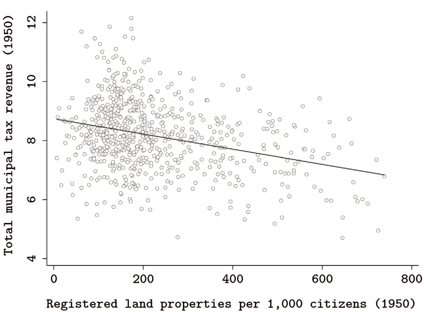
Moreover, if the observed patterns were a product of ever-increasing property fragmentation in Conservative municipalities, we would expect per capita tax revenues to decrease with the number of registered properties (as smaller holdings, being less valuable, would pay less property tax each). Total revenues from all landholdings, however, would not necessarily decrease. Figure 2 reports the unadjusted relationship between the number of registered properties per one thousand citizens and total tax revenues for 1950 (after the 1930s reforms) at the municipal level. The same figure is available for the mid-1960s (after the 1961 reform) in the appendix. In both periods, there is a clear negative relationship between per capita cadastral inscription and total tax extraction.
Legibility and Fiscal Capacity Across Colombian Municipalities
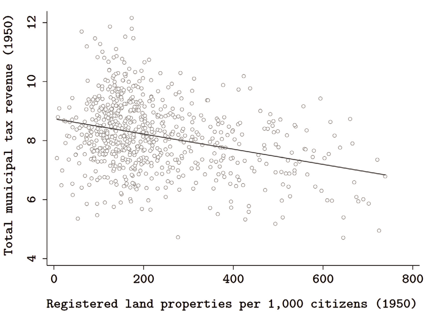
This pattern is hard to reconcile with the conventional state-building narrative, by which governing elites incorporate landholders into property registers to increase extraction, and thus legibility and taxation go hand-in-hand. Instead, it is consistent with local landholders in Conservative areas’ strategically distorting the state’s vision, so as to protect their property claims from Liberal-led reform and simultaneously escape the fiscal burden—visibility without taxation.
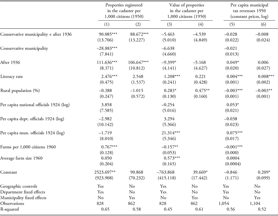
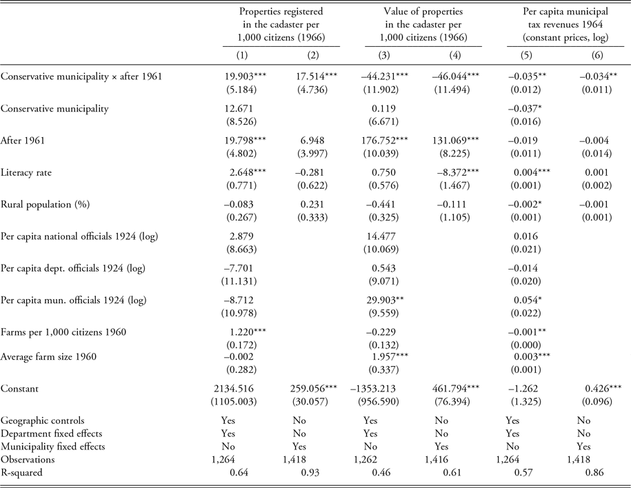
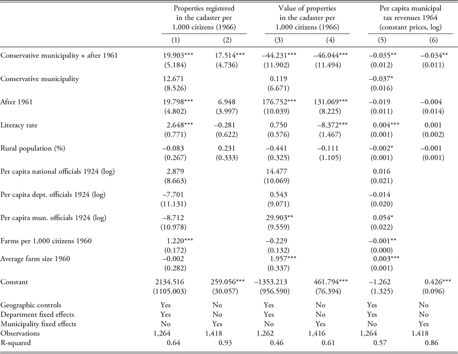
Several model specifications based on the foregoing equation were run to more formally remove potential confounding. Results for the effect of the 1936 and 1961 reforms appear in tables 1 and 2, respectively. In each table, columns 1 and 2 report results for cadastral registration, columns 3 and 4 for land property values, and columns 5 and 6 for fiscal capacity. In all cases, odd-numbered models include all covariates and departmental fixed effects. Even-numbered models introduce municipal fixed effects, thereby exploiting the within-municipality variation exclusively (all time-invariant predictors drop out). Results do not depend on the inclusion of specific covariates, as shown by more parsimonious specifications included in the online appendix.
Difference-in-Differences Estimates: Effect of the 1936 Liberal Land Reform on Legibility and Fiscal Capacity

*p < 0.05, **p < 0.01, ***p < 0.001
Note: OLS models. Parentheses contain clustered standard errors at the municipality level. Geographic controls are the distance between the municipal seat and the department’s capital (km); altitude, latitude, longitude of the municipal seat; average annual rainfall (mm); surface area (km2, logged); the shares of land suitable for agriculture and livestock; and an indicator variable for department capitals.
There are three main findings. First, Conservative municipalities are always associated with larger increases in property registration after the passage of land reforms (positive and significant DiD estimates in columns 1–2). Second, such larger increases in registration do not produce higher tax revenues in Conservative areas (DiD estimates that are not statistically different from zero, or even negative and significant, in columns 5–6). Third, neither does the official value of all land property in Conservative municipalities increase in proportion to the increase in registration (again zero or negative DiD estimates in columns 3–4). This pattern is consistent with the development of a “one-eyed” state, a state that recognizes ownership claims but not actual property values.
Column 1 of table 1 indicates that on average, Conservative municipalities saw an extra increase in the number of registered land properties per one thousand citizens of approximately 90 properties between 1931 and 1950. This is a sizable difference: the increase in land property registration in the average Conservative municipality (111.6 + 90 = 201.6) is some 80 percent larger than in the average Liberal one (111.6). This result is robust to the inclusion of department fixed effects, a range of geographic factors, detailed measures of preexisting state presence, literacy rates, rurality, and the two measures of objective landholding inequality in the municipality.Footnote 15
As we would expect, the number of properties in the cadaster is higher where, according to the first agrarian census, more actual farms existed. Yet crucially, the coefficient on the interaction term remains significant after inclusion of this variable, suggesting that the larger increases in cadastral registration in Conservative municipalities are not merely reflecting increasing fractionalization of property. Furthermore, the coefficient remains precisely estimated and similar in size when municipality fixed effects are added in column 2 to rely exclusively on within-municipality changes over time.
In columns 5 and 6 of table 1, we see that despite the larger expansion in the coverage of the cadaster in Conservative municipalities between 1931 and 1950, tax revenues per capita did not increase differentially in these areas. This goes against conventional arguments about state legibility, which would imply a positive and significant effect, given the expansion in the state’s ability to identify and “observe” landowners. However, the DiD estimate is not statistically significant and is negative.
Table 2 replicates the analysis for the second agrarian reform of 1961, with the only difference that data availability now allows focusing on the per capita revenues produced by the land property tax exclusively (columns 5–6). Again, we see that landholders in Conservative areas came under the state’s purview at higher rates than their Liberal counterparts (columns 1–2). As per column 1, twice as many land properties were registered in the average Conservative as in the average Liberal municipality between 1958 and 1966 (19.8 + 19.9 = 39.7 versus 19.8 properties per 1,000 people).
Difference-in-Differences Estimates: Effect of the 1961 Land Reform on Legibility and Fiscal Capacity
*p < 0.05, **p < 0.01, ***p < 0.001
Note: OLS models. Parentheses contain clustered standard errors at the municipality level. Geographic controls are the distance between the municipal seat and the department’s capital (km); altitude, latitude, longitude of the municipal seat; average annual rainfall (mm); surface area (km2, logged); the shares of land suitable for agriculture and livestock; and an indicator variable for department capitals.
Yet this time, the negative DiD estimates for fiscal extraction (columns 5–6) are also significant, indicating that Conservative tax yields not only did not improve with respect to Liberal municipalities between 1961 and 1964, but worsened. Land tax revenues per person were already lower in Conservative than in Liberal municipalities by 1961. After the new reform attempt, they lag farther behind. Notwithstanding the larger increase in the number of officially registered properties, growth in land tax revenues per capita was approximately 3.5 percent lower in Conservative areas, in real terms (DiD estimates in columns 5–6). Again, the traditional focus on legibility as a state strategy for increased tax extraction cannot explain this result.
Why does more land registration in Conservative territory not translate to more tax revenue? Results for models 3 and 4 in both tables, using total land value assessments per one thousand citizens as an outcome variable, are consistent with the proposed explanation: systematic undervaluation of registered land property. As with taxation, we do not see the recorded value of landed wealth increasing more in Conservative areas in either reform period (the DiD estimates are not positive and significant in either case), as would have occurred, under unbiased assessment procedures, with the disproportionate increase in the number of registered land properties. The coefficients of the interaction term in columns 3–4 are negative in both tables. For the 1961 reform (table 2), they are also significant, indicating that though more property was registered in Conservative than in Liberal municipalities between 1958 and 1966 (columns 1–2), the sum of value assessments actually increased more in the latter.
This finding is important because the lack of larger increases in tax revenues in Conservative municipalities could result from differences in the capacity to collect taxes due, even if value assessments of newly registered properties had been properly conducted. The results, however, point toward undervaluation of land as a landowner strategy to deflect taxation when listed in the cadaster. Overall, Conservative landholders appear to have achieved greater visibility—with its legal advantages—at a small price.
The results for both reformist periods using granular municipal data are therefore consistent with the argument that the state’s ability to “see” land property did not come with the capacity to assess its value and tax it. More than a vehicle for state extraction, legibility evolved as a tool to defend property and subvert agrarian reform.
Conclusions
This article has examined spatial and temporal patterns of state building across Colombia using newly assembled historical data on land registration and fiscal extraction, two essential procedures in the governance of territory and society by modern states. The main empirical finding is that the two were not one and the same. Instead, at decisive historical junctures, deep sociopolitical contestation over property spawned opposite trajectories of land property registration and tax extraction across Colombia’s historical partisan fracture. In each domain, a distinctive map of the state emerged.
To address this puzzle, this study shifted the analysis away from the traditional focus on legibility as a state vehicle for the extraction of resources, and onto landowners as unqualified opponents to its development. The argument was that confronted with the threat of partisan land reform, landholders in areas controlled by the opposition used registration in the cadaster—legibility—strategically to defend property claims and minimized the tax costs by keeping recorded property values down. The apparent incongruence between the breadth of state knowledge of property ownership and taxation thereby emerged as a logical byproduct of strategic behavior by social and partisan actors seeking to prevail in intense, dual struggles over land and political dominance.
The article makes three main contributions to broader debates about distributive politics, property rights, and state building. First, the theoretical framework specifies when and why landholders may prefer to appropriate legibility than to resist it. Key patterns of state development and of the political economy of land ownership throughout twentieth-century Colombia were illuminated using this framework. However, the three conditions identified as making legibility attractive for landowners, while variably present, are not particular to this case, to rural settings, or to the analyzed historical periods. Whenever contestation over land property intensifies and landholders perceive a threat to property, they face increased incentives to appear as lawful, registered taxpayers in the eyes of the state. Registration in cadastral records can help in the judicial arena and facilitate access to an important good for any landowner: legal property rights.
At the same time, landholders can be expected to make efforts to undermine surveying authorities’ capacity to assess land values, or even to capture the process, so as to limit their tax liabilities. Conservative Colombian landholders, facing Liberal-led redistributive challenges at different historical time points, appear to have successfully turned the cadaster, a purported instrument of state control and revenue extraction, into a tool of their own. They did so by ensuring that land properties, but not their actual values, were recorded. An important generalizable lesson is that “selective legibility” is a weapon in the politics of wealth defense, one that social actors may deploy to crystallize their property and tax interests in the law.
It is not exceptional for states to collect little in land property taxes despite possessing knowledge of land ownership. Be it in historical agrarian settings or in contemporary urban neighborhoods, established landowners are often not beyond the reach of cadastral maps. It is the poorest citizens who typically live in informal settlements, fall outside official registers, and lack property rights—who are “unseen” by the state. According to a database produced by the Lincoln Institute of Land Policy over a period of 15 years, including data for a sample of 127 local jurisdictions in 15 Latin American countries where the property is tax is collected, 83 percent of total properties in the average jurisdiction are registered in the land cadaster (Lincoln Institute n.d.).
Yet the property tax—a direct, economically efficient, and progressive tax—has failed to live up to its potential as a source of public revenue. In Latin America, revenues from taxes on immovable land property barely averaged 0.3 percent of GDP in 2016, versus an OECD average of 1.1 percent (OECD Library 2019, 116). The theoretical logic advanced in this article may help explain this general pattern of legibility over property with low taxation. Indeed, the political influence of registered landowners and their opposition to valuations that reflect market prices are considered important sources of the underperformance of the property tax (OECD Library 2019, chap. 3). Because it is typically the main fiscal tool in the hands of local governments around the world, such poor performance is a major cause of suboptimal local public goods provision.
A second important theoretical insight derived from the article is that state building and the development of legibility are entangled in distributive politics. Through the cadastral register, the prime technology to observe land property, the Colombian state recognized the property claims of some but winked at the actual value of their land. In contrast, others, like many peasant settlers, were kept off the state’s visual range and thus insecure, unable to share in its services, and vulnerable to dispossession. This illustrates how state building or land reform projects may stall, due to selective societal pushback and strategic behavior from property owners seeking to evade the tax state and simultaneously avail themselves of the public power for property defense.
The more general implication is that because different types of state capacity have distinct distributional consequences, we must disaggregate state building in two respects simultaneously: geographically and functionally (Soifer 2016). At their core, states are instruments to exercise power over others. At the same time, they are sources of services and citizen rights whose distribution is contested. It follows that parties and social groups locked in conflict with each other are likely to strategically embrace or resist the distinct components of state capacity—for example, legibility and taxation—for their own gain. In the current scholarly reappraisal of the crucial role of states in creating order and prosperity, we must therefore remain attentive to the ways that state-building patterns, along with state instruments like land cadasters, reflect past distributional conflicts and power asymmetries in society.
A final relevant contribution concerns the role of political parties and domestic antagonisms in state formation. The strong partisan effects uncovered here for Colombia provide evidence that the territorial distribution of support for historically contending political camps shapes the geography of state power. In the terminology of Harbers and Steele (this issue), Colombia’s deep historical partisan divide engendered a “disjointed” state, with selective vision and uneven fiscal strength.
More generally, historical domestic cleavages can be expected to shape the reach of the state because they organize efforts at state building and state deflecting (Sánchez-Talanquer Reference Sánchez-Talanquer2017). Polarization promotes party building as elites seek to outcompete rivals (e.g., Levitsky et al. 2016). Its effects, however, carry over to the arena of state development. Polarization increases the likelihood of partisan state building and of uneven social responses to the state across party lines. In doing so, it may complicate the rise of states that broadly distribute rights and duties across territory and social divides.
Supporting Information
Additional supporting materials may be found with the online version of this article at the publisher’s website: Appendix.