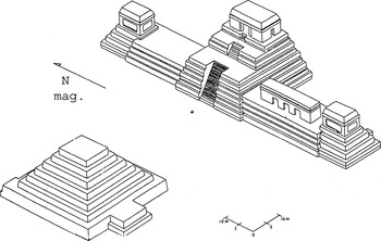
In 1924, the archaeologist Frans Blom described a distinctive cluster of structures in the northeastern portion of the Lowland Maya site of Uaxactun, Guatemala (Figure 1; Blom 1924; Ricketson 1928a; Ricketson and Ricketson 1937; Ruppert 1940). Labeled “Group E,” this configuration consisted of a western pyramid (Structure E-VII) opposite three north–south aligned structures (Structures E-I, E-II, and E-III) on a low platform defining the eastern edge of the plaza (Blom 1924). Blom recognized that the assemblage was precisely oriented on an east–west axis, and further investigation convinced him that the three eastern structures marked the position of the sun at sunrise on the equinoxes and solstices when viewed from the western pyramid. Therefore, Blom concluded that the E-group complex was a solar observatory. These considerations, combined with the remarkable preservation of Structure E-VII-sub—at that time the earliest-known structure in the Maya Lowlands—made Group E at Uaxactun one of the earliest and best-known architectural assemblages in the Maya world.

Group E, Uaxactun, Guatemala (after Rice 2004:Figure 4.3).
Since Blom's work, E-group arrangements have been identified, often in variant forms, throughout the lowlands and elsewhere in Mesoamerica (Table 1), and these date from the Middle Preclassic (ca. 700–400 b.c.) through the Terminal Classic (ca. a.d. 800–950) period. Most generally, the Lowland Maya E-group arrangement consists of a small platform on the west side of a plaza opposite the central of three temples on a north–south-oriented platform to the east. The western structure is often “radial” (Cohodas 1980): a tiered platform, square in plan, with stairways on all four sides, usually without a masonry superstructure.
Lowland Maya sites with “E-group” complexes and variants

As more E-group assemblages have been investigated, their astronomical meaning and function has been questioned, and substantial evidence from excavation and epigraphy now can be incorporated into their interpretation. Here we review available data on E-groups, including their history, construction variants, and theories about their functions. We conclude that E-groups were not precise timekeeping instruments in stone but functioned more symbolically as settings for large-scale ritual concerning the solar cycle, the sociopolitical and religious role of which may have varied through time and space.
HISTORY AND GEOGRAPHICAL DISTRIBUTION
Temporal Distribution
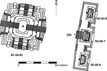
The earliest known Lowland Maya E-groups are at Uaxactun, Tikal, El Mirador, Nakbe, and Güiro/Wakna and date to the Preclassic period (see Chase 1983:1245, 1985:36; Coe 1965:23). Middle Preclassic structures in the East Plaza of Tikal's Mundo Perdido, or “Lost World,” complex (Figure 2) might be the earliest known examples of this presumed solar observatory configuration in the lowlands (Fialko 1988; Laporte and Fialko 1990, 1995). This arrangement consists of a radial platform, Structure 5C-54-1st, on the west side of a plaza facing a north–south elongated platform with the three temples of Structure 5D-84/88-1st to the east. The first (ca. 700–600 b.c.) building episode of these structures was simple: a radial structure situated opposite but off-center a long, narrow, north–south mound with stairs on the center line of each side. These were later overbuilt during the late Middle Preclassic period (Tzek ceramic complex and phase, 500–400 b.c.), and remodeled in the early Late Preclassic (Chuen, 400–200 b.c.).

Mundo Perdido, Tikal, Guatemala (after Rice 2004:Figure 4.4).
Although archaeologists associate E-groups with the Lowland Maya, they are not uncommon elsewhere in Mesoamerica, particularly in the isthmian area (Clark and Hansen 2001). In highland Chiapas, in the lower Central Depression of the Río Grijalva, Escalera-phase (ca. 600–450 b.c.) civic-ceremonial architecture commonly includes a north–south linear mound, sometimes in cruciform shape, with a centered platform to the west. These structural pairs have been found at “San Isidro, Mirador, Tzutzuculi, La Libertad, Chiapa de Corzo, Finca Acapulco, Ocozocoautla, Vistahermosa and five or more other sites” in Chiapas (Lee 1989:207, 225; Lowe 1977:224).
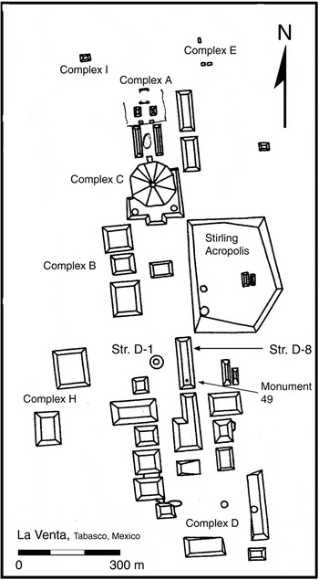
The linear-mound-plus-western-platform combination is unusual in the Gulf coastal region, but a similar arrangement can be found at the southern end of the Main Plaza at La Venta, Tabasco, Mexico (Figure 3; Drucker et al. 1959; Reilly 1999): Structure D-8, formerly referred to as the “Long Mound” in Group B, is a long, narrow mound with a north–south axis. A low truncated conical structure (D-1) sits to the west of Mound D-8 on the central axis. A basalt column (Monument 49) was found set into the southern end of the north–south linear Structure D-8, and Philip Drucker (1952:9; see also Lee 1989:Figure 4.10) suggested that three such columns might originally have been set in a line on top of this mound. If so, the three columns might have marked sight lines from the western platform (Structure D-1) to sunrise on the solstices and equinoxes. The linear-mound-plus-platform arrangements found in Middle Preclassic-period (or Formative-period) Chiapas and elsewhere, including the early one at Tikal, originally might have supported similar markers—perhaps smaller stone columns or perishable wooden poles—placed to identify sunrise sight lines or the solar zeniths. Such arrangements could have functioned as early observatory complexes.

La Venta, Tabasco, Mexico (after Reilly 1999:Figure 1.1b).
Elsewhere, a linear-mound-with-western-platform arrangement appears in the eastern part of the site of Tlalancaleca, in Puebla in the Mexican highlands (García Cook 1981:251). The date of this complex is not certain, although it is likely to date to the period 800–400/300 b.c. E-group arrangements also have been found in the Late Preclassic/Formative period at several Highland Maya sites in the Valley of Guatemala, including Kaminaljuyu, Rincon, Rosario-Naranjo, Cruz de Cotió, San Isidro II, and Las Charcas (Valdés 1997:83, citing Carson Murdy).
In the lowlands, the site of Nakbe has an E-group complex that may date to the late Middle Preclassic period, contemporary with that at Tikal (Hansen 2000). The Tigre Complex E-group at El Mirador seems to date from the Late Preclassic, as do the E-groups at Cenote and Paxcaman (Chase 1985:37), Colha (Hester and Eaton 1982; Hester et al. 1980), Pacbitun (Healy 1990), and a possible E-group variant at Cahal Pech (Awe and Campbell 1988). The latest E-group, according to available evidence, appears to be that at Nohmul, with a construction period sometime in the Terminal Classic or Early Postclassic period (Hammond 1985:47). Thus, the construction of E-groups in general appears to have spanned most of Preclassic and Classic Maya history.
Spatial Patterning
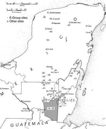
The currently known spatial distribution of E-groups (Figure 4) is wide and probably incomplete, and it provides little information about the significance of this complex, aside from an indication that it was predominantly a Lowland Maya phenomenon (Ruppert 1940:224) and not restricted to large sites. Typically, there is only one E-group at a site, although the medium-size site of Yaxha has E-groups in both Plaza F and Plaza C (Hellmuth 1971; Heyden and Gendrop 1980:52, 93, 137). Clemency Coggins (1983; also Coggins and Drucker 1988) has suggested that there are also two E-group assemblages at Dzibilchaltun.

Map of the Maya area showing E-group sites.
The similarity in shape between the massive, centrally located Ciudadela at Teotihuacan and the Maya E-group complex has been noted by Juan Pedro Laporte and Vilma Fialko (1990:59; Laporte 2003:215) and others (Cabrera Castro 2000; Morante López 1996). We, however, are not yet persuaded that the resemblance was intentional and agree with George Cowgill (2003:323), who comments, “Seeing a resemblance requires one to ignore the North and South Platforms and everything else in the Ciudadela. If the Ciudadela had been intended as a place to enact the practices connected with Maya astronomical groups, I would expect it to have looked far more like Maya examples.” Although evidence beyond form has not yet been offered, and processes that might explain the resemblance are unclear, the argument warrants consideration because interaction between the Maya area and Teotihuacan is well established (see papers in Braswell 2003), and the origins of Teotihuacan's architectural style increasingly appear eclectic (Demarest and Foias 1993).
E-Group Variants
Arlen Chase (1983:1301; see also Chase and Chase 1995) categorized known E-groups into three types on the basis of their formal characteristics. In Chase's first type, exemplified by the assemblage at Uaxactun (Figure 1), the three eastern structures are of approximately equal size and sit on a single platform. In the second type (the “Cenote Style”), this portion of the grouping is less consistent from north to south, and the central section tends to be larger or to have an easterly extension in comparison with relatively small southern and northern sections (Figure 5). Members of Chase's third type (the “Cenote Variant”) seem to be defined primarily as anomalies, having significant morphological differences from the two more easily recognizable types described earlier.

Cenote, Guatemala (after Chase 1985:39).
In an earlier study, James Aimers (1993:Figures 13–15) plotted the spatial distribution of 45 Lowland Maya E-groups classified according to Chase's types, but no obvious geographical patterning was apparent. None of the types defined by Chase appear to be more common at larger sites; nor did specific environments appear to have distinctive E-group types (e.g., Belize Valley, riverine locations, Peten). In addition, examination of site and structure plans provided little indication of strict rules regarding the morphology of the E-group. Each site seemed to be a variation on a recognizable theme. Despite this variability, however, the wide distribution of E-groups as a distinctive civic-ceremonial architectural complex suggests a network of shared beliefs and ritual in Mesoamerica from at least the Middle Preclassic period or earlier (see also Aveni et al. 2003; Culbert 1991).
ASTRONOMY AND RITUAL IN THE INTERRPETATION OF THE MAYA E-GROUP
The Solar Observatory Hypothesis
Blom (1924) suggested that the Late Preclassic E-group configuration at Uaxactun functioned as a solar-seasonal observatory complex marking the dates of the solstices: From a viewing position on the western radial structure, sunrise at the summer solstice occurs over the northern temple, and sunrise at the winter solstice occurs over the southern structure. Later, Oliver Ricketson (1928a, 1928b) suggested that on the equinoxes the sun would rise behind the central eastern structure, but he expressed some doubt as to the astronomical significance of its orientation:
One question … can be appropriately raised at this time, and that is whether this complex of buildings is a true observatory, or planned to mark the already known directions of the four significant annual positions of the sun? The writer is strongly in favor of the latter theory…. The writer believes that these buildings were erected in their respective positions as temples dedicated to the four seasons, or the four most significant positions of the sun in the course of the solar year, and that their erection is to be more closely associated with geomancy than with astronomy (Ricketson 1928b:439–440).
Despite this caveat, Ricketson compared Group E to the Caracol at Chichen Itza, a round structure typically characterized as an observatory (see Aveni 2001:273–282 for a full discussion; see also Aveni et al. 1975). As a result of this ambiguity, in only four years Group E at Uaxactun was established in the literature as a bona fide astronomical observatory rather than one that merely marked the position of already known celestial phenomena.
Here it is appropriate to clarify what we mean by the term observatory in attributing function to E-groups. Anthony Aveni, Anne Dowd, and Benjamin Vining (2003:172) recently argued that, “if seeing the sun [rising points] can be shown to have been a part of the [building] scheme, then regardless of whether the Maya were watching it scientifically or ceremonially, the associated architectural complex may be regarded as an observatory.” We, however, prefer a definition aligned more closely with Western scientific usage, which postulates an observatory function as the primary purpose of the structure or complex. By this thinking, if E-group structural arrangements as originally constructed provided accurate sightlines to solsticial sunrises, and then were modified over time in ways that compromised this accuracy, the complex ceased to function as an observatory sensu stricto.
The confusion engendered by Ricketson's 1928 articles is evident in Karl Ruppert's key discussion of E-groups, published more than a decade later. Ruppert (1977 [1940]:222) reported 19 examples in a relatively circumscribed area of northeastern Peten, southern Quintana Roo, and Belize; 13 “in almost pure form” like that of Uaxactun; and six that were “less clear.” He concluded that the Uaxactun observational complex developed first, and the other assemblages, which he assumed to be later, functioned merely as settings for derived ritual.
This temporal and functional dichotomy between astronomical and ritual complexes has influenced every subsequent discussion of E-groups and is evident in alternative terms for the E-group arrangement. These include Complejo Conmemorativo Astronómico (Fialko 1988) and Complejo de Ritual Público (Laporte 1996). Here we maintain the original, functionally neutral term E-group to refer to this architectural complex.
Astronomy and Scheduling
Astronomical accuracy is emphasized most strongly in interpretations that suggest E-groups were “calendars in stone” constructed to assist farmers in scheduling agricultural activities (e.g., Rathje 1972, 1978). This is something of a straw man, set up and knocked down by most scholars dealing with the practical implications of the Maya calendar. Ethnographic observation shows that Maya farmers would not need to be told when to carry out the various activities related to the agricultural cycle; weather and visible growth cycles clearly indicate when it is time to perform certain tasks (Redfield and Villa Rojas 1934:44; Redfield and Warner 1940). The assemblages may still commemorate important agricultural dates, however.
William Rathje (1972:233, 1978) also proposed that E-groups developed as precise timekeeping mechanisms to schedule trade in the resource-poor lowlands. Rathje's spatial-distribution model was based on Ruppert's work of 1940, and his hypothesis resulted from the application of a theoretical model derived from economic geography to a body of data to which it may simply be inappropriate. It is now evident, for example, that the E-group has a much wider occurrence than earlier thought. The most significant problem with Rathje's hypothesis was his assumption that E-groups were accurate timekeeping devices, which has never been demonstrated.
A related, but more powerful, consideration comes from recent studies by Aveni and colleagues (2003) who, following previous investigations (Aveni and Hartung 1986), suggest that the E-group alignments were targeted toward observations of the solar zeniths. In particular, they note intervals of multiples of 20 days leading to the first solar zenith, occurring on May 10 at the central Peten latitude of circa 17° 31′ N. These would have been marked, they argue, in architectural complexes where rituals might have been carried out as “anticipatory sun sightings during the interval leading up to the planting season” (Aveni et al. 2003:162–163).
Ritual and Geomancy
At the opposite side of the interpretive spectrum, John Carlson (1981) suggested that a system of geomancy, not unlike that practiced by the ancient Chinese (and still in use), might explain some of the irregularities of Maya sites, and of the E-group complex in particular. Just as ancient astronomers tried to make sense of the night sky and the movement of the sun through observation and attendant ritual, a system of geomancy “explains” physical geography and provides a system of rules for manipulating the perceived power of the landscape. In fact, geomancy can be considered a terrestrial version of astrology (Wheatley 1971). A tendency to see the landscape as alive and sacred has been documented in many societies (see, for example, Howard 1986:350; Hugh-Jones 1979:235; Thomas 1990:169), including the Maya (see Scully 1991:2–17; Townsend 1982; Vogt 1981). Carlson (1981:188) suggested that, aside from Uaxactun, “other Group E-type structures may align to topographical or other celestial features,” an idea that otherwise had been overlooked since it was raised by Ricketson.
TESTING THE SOLAR-OBSERVATORY HYPOTHESIS
Equinoxes
Although many archaeoastronomical investigations are complicated by the changing positions of celestial bodies over time, the position of the sun at particular times of the year remains relatively constant over thousands of years. This means that the solar-observatory hypothesis can be tested. Because the sun rises due east on the equinoxes, if the Maya were interested in accurately “monumentalizing” the position of the sun on these days, the assemblages should have a fairly precise east–west alignment.
Although many older site plans are conventionalized, and some do not distinguish true from magnetic north, examination of site plans suggests that the rising of the sun on the equinoxes would not coincide with the precise center of the eastern structures in the great majority of 45 cases examined (Aimers 1993:Table 4), even allowing for a large margin of error in the accuracy of the maps. Eliminating five conventionalized maps from the calculations, fewer than 25 percent (9 of 40) of the assemblages are within 5° of due east. Important for these conclusions is that the sun on the horizon appears to have a width of only half a degree; thus, a very slight skew will be significant (Carlson 1974:108; Flower 1990:14). Even at Uaxactun, the equinoctial alignment is not precise, both because of a deviation of the axis from due east and because in the tropics, the sun, after rising, appears to travel diagonally at an angle of approximately 15° south of vertical.
The sun on the horizon appears to have a diameter of approximately one half of a degree, and it takes only a few days for the sun to move 2° (or about four times its apparent width) along the horizon near the equinoxes. This means that a truly accurate alignment for an observation of the equinoctial rising of the sun would have the architectural configuration aligned within 2° north or south of due east (which is to say, a greater deviation from due east would lead to a large discrepancy in determining the date of the equinox). Of the E-groups examined, only El Venado, Uaxactun, and Ucanal have this characteristic, and the map for El Venado is conventionalized. This is a significant indication that the majority of these structures were not created rigorously to mark equinoctial sunrise positions. Of course, this does not rule out alignments with other celestial phenomena, including the solar zeniths (see Aveni et al. 2003).
Solstices
Near the solstices, the sun moves a distance equal to its own diameter in about 10 days (Aveni and Hartung 1989:459). Thus, architectural alignments must be extremely accurate to serve as precise solstitial markers. Furthermore, at the latitude at which these configurations are located, the angle formed between true east and a vector connecting a given point on the true east line to the position of the sun at the solstice sunrise is approximately 24.5° (Broda 1982:81). Examination of site maps revealed that none of the assemblages has the precise angle required (Aimers 1993).
If the viewer of the sunrise changes vertical position in the E-group, the apparent position of the sun on the horizon also changes, and this could compensate for otherwise inaccurate alignments: “By varying the height of the observer relative to the foresight, whether it be a building or a portion of the horizon, it may be possible to account for many of the orientations skewed 0 degrees to 10 degrees eastward from the cardinal points by sunrise observations at the equinox” (Aveni 1980:249). Nevertheless, the orientations of several of the E-group structures appear to be too inaccurate to be accounted for by this hypothesis (e.g., Pacbitun). Although the limitations of site plans have been noted, many of the plans indicate a skew in the alignments of more than 10° (Aimers 1993:Table 4)
Horizontal changes in the position of an observer on the west (radial) building will also change the apparent positions of the southeastern and northeastern buildings necessary for alignments with the solstitial sunrises. Several assemblages can be eliminated as possible solstitial observatories (on the basis of maps) because it is not possible to observe the rising of the sun over the eastern structures: Baking Pot, Cahal Pech, Colha, Comalcalco, El Venado, Kabah, Lamanai, La Muñeca, Naachtun, Río Bec, and Xultun. San José has the correct alignment for the summer solstice, but not for the winter solstice.
In 1991, Aimers and colleagues conducted field observations of sunrise in E-groups at six sites on and near the summer solstice. At the site of Baking Pot, the sun appeared in an appropriate place when viewed from the center of the western structure at 5:55 a.m. on June 22. The Blackman Eddy assemblage “worked” satisfactorily, with the sun appearing in the appropriate position at approximately 6 a.m. on June 22. Cahal Pech is unusual in that it does not have a western structure conforming to the typical radial structure associated with other E-groups. There, sunrise was observed from the stairs of the range structure delimiting the western edge of the plaza. At 6:45 a.m., the sun appeared somewhat to the south of the center of the southeastern structure. At Pacbitun, the sun appeared at 5:50 a.m. in a position approximately halfway up the slope of the northern side of the central eastern structure on June 22. Observers at Xunantunich estimated the sun to have first appeared shortly after 6 a.m. on June 22, close to the southern edge of the northeastern structure. At Yaxha Plaza C, the sun appeared at 6:45 a.m. on June 20 near the southern edge of the northeastern structure. In sum, only two of the six E-group assemblages accurately marked the position of the sun at sunrise on the summer solstice: Baking Pot and Blackman Eddy. Further, Cahal Pech should probably be eliminated, as it does not have a western structure. These observations do not support the persistent belief that E-groups were astronomically accurate markers of the solstices and equinoxes.
Accuracy
It is possible that these E-group assemblages were planned incorrectly. For example, there is evidence that the Templo Mayor at Tenochtitlan was planned incorrectly and did not accurately mark the sunrise on the equinoxes (Aveni 2003:159; Aveni et al. 1975:985). However, it is difficult to accept the proposition that Maya astronomers, who had “succeeded in tabulating the motion of Venus to .08 part of a day in 481 years” (Aveni 1980:191), would have been unable to produce accurate alignments, and it is particularly hard to imagine that Maya architectural planners repeatedly would have produced incorrect alignments. Furthermore, although large masonry observatories are known in the Maya area (e.g., the Caracol at Chichen Itza), massive architectural assemblages would be an unnecessarily time-consuming and labor-intensive instrument for astronomical observation: “Four perpendicular sticks a few inches high, correctly set up on a properly oriented board, would have served the same purpose” (Ricketson (1928b:440). The use of sticks for solar observation is widespread in the New World (particularly in Mesoamerica), and there may be iconographic evidence of such an instrument (Aveni 1980:62–66, 286–311, 2001:20–21; see also Coggins 1983; Digby 1974). In other words, it seems more likely that precise architectural indicators of solstice and equinox positions were less important to the ancient Maya than they have been to archaeologists.
Less functionally utilitarian factors probably influenced the design of these large, centrally located complexes. For example, E-group architects intentionally might have incorporated adjustments and asymmetries into the eastern structures to create hierophanies (interplays of light and shadow that bespeak sacred mysteries; Aveni et al. 2003:173). In addition, Harold Turner (1979:29) has shown that earthly replicas of divine models are often intentionally imperfect. The imprecision of E-groups as solar markers may be due to planning in which astronomical accuracy could be subordinated to other cognitive schema, as it is in contemporary Mesoamerican communities:
[P]easants have neither the equipment (for instance, accurate compasses) nor the knowledge of the night-time sky necessary to produce accurate alignments. Furthermore, natural features are set there “by the hands of the gods” and not by human design, so that the architectural model is only a vision, an approximation of abstracted armatures, a compromise between the real position on the earth's surface of natural markers such as mountains, solar or astronomical markers, and man made or imagined markers (Hunt 1977:204).
This explanation for the imprecision of architectural orientations is also valid cross-culturally (see, for example, Guidoni 1975:92, 154, 161, for similar cases among the Indonesian Nias islanders, the Dogon of Mali, and the West African Hausa).
The siting of an E-group could have been planned through a process in which various types of “numerically patterned phenomena, such as geographic directions, seasons, and celestial events” were linked (Hunt 1977:211; see also Brotherston 1982:110–112; Hunt 1977:212–13 provides examples from the Codex Borgia). Aside from many known systems of geomancy (e.g., Chinese, Japanese, West African [Ife], early medieval British, and Southeast Asian), astronomical numerology in European art and architecture fits this pattern (Hersey 1976). In Western astronomy, Copernicus and Kepler addressed astronomical problems with Neo-Platonic and Pythagorean preconceptions of harmony and order that made their models impossibly inaccurate. Johanna Broda (1989:494) has suggested that “ancient astronomy should be broadened to include the observation of the natural environment in more general terms,” and similar geomantic architectural orientation systems have been suggested for Teotihuacan (Heyden 1981) and Monte Alban (Hartung 1981). In the Maya case, an affinity for this sort of transformational structure is well demonstrated by the complex associations among colors, animals, plants, directions, gods, and seasons, as evident from the archaeological record, ethnohistorical accounts, and ethnography. We do not know which of these myriad factors may have influenced E-group design, but the sun's annual movements along the horizon were apparently not the only factors.
Conclusions about the Solar-Observatory Hypothesis
Anthony Aveni and Horst Hartung (1989) made accurate astronomical measurements at Uaxactun in 1988 and concluded that the E-group there accurately would have marked the position of the sun on the solstices but would have been slightly inaccurate in marking the equinoxes. The solstice sun rises not over the center of the southeastern and northeastern structures but over their southern and northern edges, respectively, and the equinoctial sunrise would be slightly off-center. Due to the slow movement of the sun around the solstices, Aveni noted, “[W]e must caution against concluding that … the Group E complex in any sense offered a precise means for determining the solstitial dates” (Aveni and Hartung 1989:445).
Aveni and Hartung (1989:451) further suggested that at Uaxactun the originally functioning horizon-based “observatory” went through a series of architectural elaborations that eventually negated its utility as a precise marker of solar movement. Importantly, due to vertical elaboration of the western structure (Structure E-VII) in its final stages,
all of the sunrise events would have taken place along a natural horizon that lay well above the level of the platform and its three buildings. It is likely that by this time the complex could not have functioned as a solar observatory in any sense. (Aveni and Hartung 1989:447)
This raises the prospect that originally accurate solar observatories became increasingly inaccurate through modifications undertaken in later eras, perhaps after their functional characteristics had been forgotten or otherwise neglected. The authors suggested that “most E-Group complexes might have been non-functioning copies of the astronomically operational archetype at Uaxactun” (Aveni and Hartung 1989:452; but cf. Aveni et al. 2003 for a rethinking of this idea) and were likely the focus for “ritual and ceremony.” This idea returns the interpretation of Maya E-groups to Ricketson's suggestion half a century earlier.
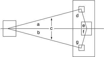
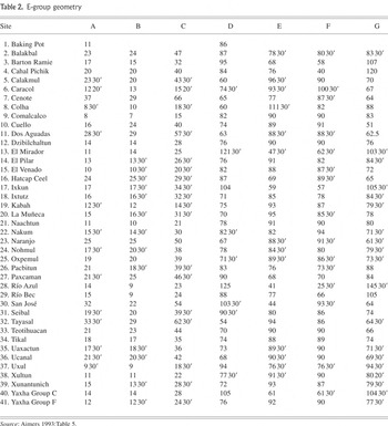
Although the accuracy of the E-groups examined thus far would seem to argue against a strict solar-observatory hypothesis as initially argued by Blom and Ricketson in the 1920s, the orientations of the buildings are also too consistent to ignore. Measurements of various angles in the assemblages (Figure 6) were taken to determine whether there is any consistency in the proportion of the structures (Table 2). Notably, there is a significant variation in angles A and B, which supports the idea that these were not functioning solar observatories, yet the angles E and F are much more consistent in being slightly less than 90° (for approximately 75% of the assemblages). Generally, these measurements suggest that although the geometry and proportion of the overall configuration was maintained rather consistently, the orientation—and, therefore, the possible alignments—vary greatly. The overall geometry and proportion of these structures makes them archaeologically recognizable as much as their orientation and may have been more important in their design than accurate solar alignment.

E-group geometry.
E-group geometry

In sum, astronomical measurements and site-plan investigations reveal that none of these sites' E-groups, including that at Uaxactun, are oriented with sufficient precision to have functioned as true observatories for the cyclical positions of the sun. Although it is not possible to fully support Carlson's (1981:188) suggestion that none of the E-groups in the Maya area “have the correct orientation to be functional observatories,” it appears that most E-groups were not “correctly” oriented in a functional (i.e., astronomically accurate) sense. The reasons for their construction and use probably differ from the Western notion of “observatory” as a scientific instrument for the precise measurement of celestial movements.
RITUAL CYCLES
Although the reasons for the varied yet consistent orientations of E-groups are still not understood, there are indications of the ritual role of these monumental structures. We suggest that E-groups emerged initially in association with celebrations of annual solar cycling. At some time thereafter, they came to be constructed to celebrate longer calendrical cycles known as katuns and, possibly, longer cycles of 13 katuns, or approximately 256 years, called the may (see Rice 2004).
“The Shape of Time:” Radial Structures
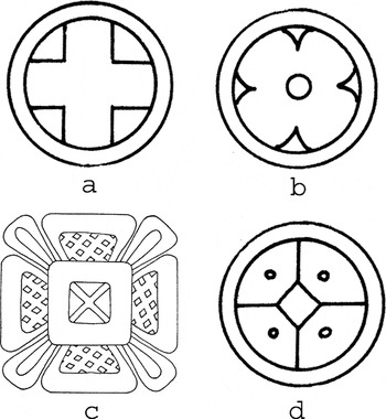
Monumental architecture is always planned, and the design of large buildings often incorporates symbolic references at various scales, including the overall shape and applied ornamentation. One clue that E-groups were constructed to symbolize cyclical time comes from the radial structures typically situated as the western structure of this group. Because of their four projecting stairways, these structures have the shape of a cross (+) in plan view. Interpretations of Mesoamerican directional symbolism (see Kubler 1962; León-Portilla 1988:Appendix B; Pasztory 1978:110) reveal that quadripartite shapes (Figure 7) play an important role in Maya thought. The Maya word for day is k'in, which also means “sun.” The glyph for day/sun is a cartouche containing what might be interpreted as a four-petaled flower, the “petals” defined by four marks at the top, bottom, and sides of the interior. According to Coggins (1980:731),
The shape of time may … in one way, be conceptualized as a vertical four-point diagram within the ecliptic band (including a fourth point below). These points or places are: where the sun rises; where it reaches the top; where the sun sets; and where it reaches bottom. This is the equivalent of one day, which the Maya denote with the four-point Kin sign … —a two-dimensional figure that is equal to the completion of a cycle. The steps involved in this quadrangular journey vary somewhat according to Postclassic sources, but it is known that the sun was believed to ascend by steps or levels into the highest heaven, then to descend, and finally to trace a similar pattern in reverse in its journey through the underworld.
Coggins suggested that Uaxactun's Structure E-VII-sub was an intentional architectural representation of this symbol. Such stepped radial pyramids are ideal cosmograms, or symbols of a quartered, stepped universe in which the movement of the ruler up the structure and back down could represent the path of the sun (similar to David Freidel and Linda Schele's [1988] interpretation of the non-radial 5C-2d at Cerros, Belize). Marvin Cohodas (1980:208) agreed with George Kubler and Coggins that radial structures were giant k'in signs and were, furthermore, “designed for public participation in rituals regulated by the solar or agricultural calendar.”

Quadripartite signs. (a) Kan; (b) K'in; (c) Maya completion sign; (d) Lamat (after Coggins 1980:Figure 2).
Thus, the radial structure—like the quincunx; k'in day glyph; k'an cross; and lamat, or Venus glyph—is among the many Maya and Mesoamerican quadripartite figures signifying calendric and cosmic cycle completion (Coggins 1980:Figure 2). These radial structures sometimes displayed stucco reliefs (“masks”) with astrological-cosmological themes. For example, the masks on Structure E-VII-sub at Uaxactun refer to the watery underworld, the sun god, and long-lipped gods representing the earth and sky (Freidel 1979:46; Ricketson and Ricketson 1937:84). Freidel (1981) argues that together they represent the sun cycle surmounted by Venus. Importantly, because radial structures typically appear in the middle of open plazas they also represent, in Maya cosmovision, the center of the universe and the joining of the four world quarters.
Ritual and Agriculture
It seems likely that E-group architectural complexes had their inception in rituals of annual solar/agricultural cycling (Cohodas 1980). One explanation for the existence of the 260-day calendar postulates a “ritual or canonical agricultural cycle” (šprajc 2000:409; see also Aveni 2003:157–158; Tichy 1981) based on the 260 days of the “agrarian year” from roughly February (working the milpa) through October (harvest). Such a cycle would explain why eastern orientations and observations—equinoxes, solstices, quarter years, and so forth, as observed by sunrise positions on the horizon—were important and commemorated architectonically by the Maya and their isthmian neighbors. In the Early Preclassic these observation lines might have been established with perishable or temporary markers, while later permanent architectural markers were constructed to provide an appropriate ritual frame for these activities. Still later, the annual cycles would have been extended to commemorate the conjoined cycling of 365-day solar and 260-day “ritual” calendars.
Evidence for Maya agricultural ritual is extensive (see Aveni and Hartung 1986:56; Pasztory 1978:132); “the agricultural fertility cult was the most widespread, and its myths and deities were probably the most ancient” (Pasztory 1978:130). Contemporary K'iche' Maya conceive of a congruence among plant life, human life, and sunrise (Tedlock 1985:252; Tedlock 1992) and among the Chamula the sun itself is conceived to be composed of maize (Gossen 1965:143). As Joyce Marcus (1987:131) notes, there seems to have been a similar metaphorical relationship among pyramids, mountains, and agricultural fertility in Maya cosmology: “[I]t has been suggested that the lowland Maya, lacking mountains in their natural environment, used temple pyramids as homologous counterparts” (see also Schele and Freidel 1990:427). Maize may grow from the Maya kawak glyph, associated with stone, stone buildings, and mountains (Miller and Taube 1993:120; Schele and Miller 1986:45). In K'iche' mythology, mountains contained the maize and water used to make the bodies of the first real humans, and there is a similar Nahua myth (Tedlock 1985:328).
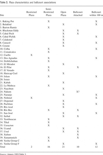
Thus, large, accessible plazas defined by monumental stone buildings may have been appropriate settings for agricultural ritual (see also Chase and Chase 1983:3, 10). Table 3 categorizes 41 E-group plazas on a simple scale of restricted, semi-restricted, and open based on plaza size and degree of enclosure by buildings. E-groups are associated most clearly with the large, open plazas thought to have been used in large-scale Maya ritual. Only two of the 41 plazas (about 5%) are of a restricted nature. With respect to E-groups, Aveni (2003:162) points out that 12 of these complexes have alignments that “match dates that fall in the midst of the dry season, the most logical points in time to conduct rituals pertaining to the anticipation of the forthcoming crop.”
Plaza characteristics and ballcourt associations

Ballgame Associations
The association of E-groups with ballcourts, ballgame imagery, and sacrifice (Table 3) is notable given that Esther Pasztory (1972, 1978:130) and others have suggested that the major significance of the Maya ballgame concerned the sun's entrance into the underworld and the related renewal of crops and fertility. Cohodas (1975:110) also included the ballgame in a complex of ideas incorporating astronomy, agriculture, and sacrifice:
[T]he mythological event of the summer solstice, the mating of the sun and moon to conceive the maize, is recorded in the ballgame myth of the Popol Vuh…. At the height of its popularity as a cult, the ballgame was probably played on the equinoxes to represent the battle of celestial and terrestrial forces. The sacrifices which culminated the game were employed as sympathetic magic to bring about the two crucial events in the yearly cycle of the sun and of agricultural activity.
This ritual complex incorporates a tension between “celestial and terrestrial forces” and may help explain evidence of ritual sacrifice at E-group locales. The most common form of sacrifice in Classic Maya art is decapitation (Schele 1984:8), and this practice was associated with the ballgame (see Soustelle 1984:3). In the Popol Vuh, for example, decapitation of the moon goddess occurs in the ballcourt (Cohodas 1975:109).
At Tikal, the Mundo Perdido E-group might have some links to ballgame ritual, given the presence of Teotihuacan imagery there and in the residential group 6C-XVI (Laporte and Fialko 1990), as well as an unusual configuration of three ballcourts on the north end of the Plaza of the Seven Temples adjacent to Mundo Perdido. A mass grave with the remains of 17 individuals dating to Manik 1 (a.d. 250–300) was found in front of the central structure of the eastern group in Mundo Perdido, although this sacrifice is more likely to have been dedicatory than ballgame-related (Laporte and Fialko 1995:56).
At Seibal, the stairway of Structure A-10, the eastern structure of an E-group, is flanked by “Stelae” 5 and 7, which display ballgame imagery. The ballgame may have been played against that stairway, perhaps accompanied by the sacrifice of captive opponents on the stairs (Miller and Houston 1987:46, 55) and/or with the sacrificial victims used as balls (Christie 1995:171; see also hieroglyphic steps of Yaxchilan Structure 33). The northern edge of this E-group plaza is marked by radial Structure A-13, which aligns with the A-19 ballcourt; a mass burial in Structure A-13 included parts of 11 people. The individuals in this burial, which is radiocarbon-dated to a.d. 930, included two women and a child, suggesting that, as at Tikal, the burial was dedicatory rather than that of a defeated ball team (Wright 1994:161, cited in Tourtellot and González 2004:63).
Besides Tikal and Seibal, E-groups at other sites also held burials of sacrificed individuals. The headless skeleton of a 25-year-old woman with no grave goods in Structure E-VII at Uaxactun, the skull caches at San José, and the headless skeletons at Tayasal (Guthe 1921–1922, cited in Ricketson 1928a:69) are also relevant here. In addition, Uaxactun Stela 19, celebrating the 8.16.0.0.0 katun ending (a.d. 357) in the E-group, shows a kneeling captive. The presence of kneeling or prone bound prisoners is a common theme on katun-ending monuments in both the Early and Late Classic periods (Rice 2004).
Perhaps there was a Maya ritual complex involving competition in ballcourts, sacrifice on E-group stairways, and burial in nearby plazas. It does appear that Maya sacrifices lasted several days and involved both ritual torture and eventual death, usually by decapitation (Schele 1984:43). Sacrifice after the ballgame is consistent with agricultural ritual on a number of levels (see Monaghan 1990). A central symbol for most human groups, blood was considered by the Maya to be the food of the gods (see, for example, Coe 1988:277). At the Great Ballcourt at Chichen Itza, vegetative matter streams from the decapitated figure, and in what appears to be a reference to ballcourt design at Copan, three carved ballcourt marker-like stones in front of the Jaguar Staircase “show fresh young maize foliage, fertility generated through sacrifice” (Miller and Houston 1987:59).
POLITICAL RITUAL: E-GROUPS AND KATUN CYCLES
Numerous lines of evidence suggest that, out of an early context of celebrating annual solar cycling, E-groups came to be constructed specifically to celebrate longer calendrical cycles of 20 years known as katuns. This also might have been extended to 13-katun cycles of roughly 256-years known as the may (Rice 2004). To understand the significance of katuns, a brief background in Maya and Mesoamerican calendrics is needed.
The fundamental unit of time for all Mesoamerican peoples was the day (or “sun”). Days were given numbers and names within two simultaneously running calendars, one consisting of 260 days and the other of 365 days. These two calendars cycled continuously, such that any given day was identified by a number and name in both (e.g., 1 Ajaw 8 Kumk'u), and it took a total of 18,980 days, or 52 years, for the same day names and numbers to recur. The Classic Lowland Maya, however, used the more detailed “Long Count,” in which the time was measured from an arbitrary starting date of August 13, 3114 b.c. To maintain such records, they registered units of time by multiples of days, mostly but not entirely in units of 20, as follows:

Within this system, the Maya were particularly careful to record and celebrate the completion (rather than the start) of larger units of time, so-called period endings. These include the completion of katuns and their five-year subdivisions, and the endings of b'ak'tuns, by erecting carved, dated stelae. Furthermore, katuns were named by their ending day, always a day Ajaw—as, for example, Katun 8 Ajaw.
Many of the earliest katun-celebrating stela known in the Maya Lowlands were found in E-group complexes, particularly in front of or otherwise associated with the eastern structure. For example, in front of the east building of the E-group at Uaxactun, Stelae 18 and 19 commemorate the end of the 16th katun in b'ak'tun 8 (or 8.16.0.0.0 in standard notation), a Katun 3 Ajaw ending in a.d. 357 (Valdés and Fahsen 1995:204). At Tikal, the basal portion of Stela 39 celebrating the completion of 8.17.0.0.0 Katun 1 Ajaw (a.d. 376; Grube and Martin 1998:81) was found in Mundo Perdido, redeposited in the back room of Structure 5D-86-7, the central temple of the eastern side of the E-group complex. At Nakbe (Hansen 1992:84; Velásquez 1992), smashed and broken Stela 1 was found beside Structure 52, a small, low mound centered on the eastern linear mound (Structure 51) of that site's E-group. The stela, which shows two figures who could be ballplayers, might be related to an enormous altar found sealed beneath a Mamom floor (Hansen 1992:85), suggesting an extremely early date. Laporte (1993:314) proposed a date of circa a.d. 41, or 8.0.0.0.0, while others suggest an even earlier date around 500–200 b.c. (Hansen 2000:56). At El Mirador, 13 stelae (1 carved; 12 plain) were all found in the site's Great Acropolis, which is an E-group (Hansen 1991:20; Matheny 1987:332).
Unfortunately, because carved and dated period-ending stelae were not erected in the lowlands until the Late Preclassic period, this katun-ending function cannot be recognized archaeologically in earlier periods (Rice 2004). However, the practice continued through the Early Classic, as Yaxha Stelae 5 (8.16.0.0.0) and 2, stylistically dated to the Early Classic, were erected in front of the eastern structure of that site's Group F E-group, and Stela 6 (undated but stylistically early) was placed in the Group C E-group. At Caracol (Chase and Chase 1987), construction of the E-group of Group A was begun circa 300 b.c., and 19 monuments were found in the complex. Stelae 12 (apparently undated) and 20 (a.d. 487) stood in front of the central structure of the eastern group, and a cache of Early Classic monuments (Stelae 13, 14, 15, and 16 and Altar 7) was found in association with Structure A-5, the northern structure of the eastern group. Three of the latter monuments celebrate the katun endings of 9.4.0.0.0 (514), 9.5.0.0.0 (534), and 9.6.0.0.0 (554).
E-groups continued to be locations for the erection of katun-ending stelae through the Late Classic and early Terminal Classic periods. Ucanal's Plaza A, a Late Classic E-group, was the location of most of Ucanal's monuments, particularly in front of the central-eastern structure; they included two stelae, one altar, and six “monuments” (Laporte and Mejía 2002:8). At Machaquila, 18 of the site's 19 stelae and all of its six altars were found in a “stelae plaza” that appears to represent a structurally altered E-group (Graham 1967). Seven stelae and three altars stood in front of the central and southern structures on the east side; the four stelae with dates commemorate the Late Classic-period endings 9.14.0.0.0 (a.d. 711), 9.15.0.0.0 (a.d. 731), 9.15.10.0.0 (a.d. 741), and 9.16.10.0.0 (a.d. 761) (Graham 1967). Seibal “Stelae” 5 and 7 are actually paired relief panels celebrating the completion of the half-katun of 9.18.10.0.0 (a.d. 800); they were set flanking the stairway of Structure A-10, the eastern structure of an E-group. And at Calakmul, the Central Plaza is a large E-group complex where some 40 Late Classic stelae were found, 18 in front (west) of the eastern structure (Folan et al. 2001). Stela 114, dating to a.d. 435, and Stela 43, dating to the termination of a Katun 13 Ajaw in 514, were reset, probably in Terminal Classic times, into niches constructed at the base of the huge Preclassic Structure II platform south of the E-group complex (Pincemin et al. 1998).
The political significance of katun cycles becomes evident through analogy with Late Postclassic-period and early Colonial-period northern Yucatan. There, as one katun ended and a new one began every 20 years, the new katun was ritually “seated” in a particular town, which controlled tribute rights, land titles, and appointments to public office for the 20-year duration (Edmonson 1979:11, 1982:xvii). As the katun seat changed, so did the administrative lordship or priestly oversight of the period. The chief priest of each katun, who held office for the full 20 years, was referred to as b'alam (“jaguar”) and had a spokesman or speaker (chilam), who was the official prophet of the katun (Edmonson 1982:31).
In addition, the turning or cycling of katuns was accompanied by great ceremonies that Munro Edmonson (1986:21–29, Chapters 12, 29) describes as ritually structured, historico-mythological “dramas” of multiple “acts” and lasting several days. These began with a procession around the town that ended with a drinking ceremony and continued with the official “seating” of the katun as the new b'alam, or jaguar priest, of the katun took his place on the “mat of the katun.” Following this, the four Yearbearers (b'akab's, or calendar priests), who represented not only the years but also various quadripartite entities in nature, were also “seated.” Then another ceremonial procession took place in which seven priests “measured” the land, confirmed land titles, and took tribute payments. Next, the mats—symbolic seats of authority—of the lords were “counted” and ranked, and the lords declared their candidacy for various political positions. Sacrifices were carried out, accompanied by music and dancing, which was followed by a ceremonial feast and ritual “interrogation of the chiefs” on the last day of the katun. At this point, the new chilam, speaker of the jaguar priest, proclaimed the prophecy for the upcoming katun, and then the assembled lords and priests performed acts of autosacrifice.
From an archaeological viewpoint, the next “act” of the early Colonial-period katun ceremony is most interesting: The ancestors were commemorated by the erection of a cross. In earlier times, however, such commemoration was carried out by the erection of a stela (Morley and Brainerd 1956:212; Roys 1967 [1933]:161, note 1). Bishop Landa (Tozzer 1941:38–39) noted carved stones at Mayapan and reported that the Maya living nearby told him they “were accustomed to erect one of these stones every twenty years.” After this event, the celebrations continued with a recitation of the place of the current katun in mythic time and a comic “play,” concluding with a “sermon.”
Thus, in Postclassic Yucatan, stelae erection was a part of katun-ending celebrations, and 20-year katun cycles played important roles in structuring regional political affairs. The fact that katun-ending stelae were erected regularly in E-groups in the lowlands—perhaps as early as the Late Preclassic and throughout the Classic period—and in twin-pyramid complexes in Late Classic Tikal prompts two observations (see Rice 2004). One is that katun endings were clearly important occasions for ritual celebrations for more than a millennium in the Maya Lowlands, and even early on they might have structured geopolitical activity in the same way they did in early Colonial-period Yucatan. The other is that during the Late Preclassic and Classic periods, the Maya built distinctive architectural complexes that provided an appropriate frame for rituals related to calendrical cycling and their associated stone monuments.
An analysis of burials and caches in E-groups led Arlen Chase and Diane Chase (1995:100) to suggest that these complexes were associated with performance of ancestor rituals. In a related hypothesis, Laporte (1993:314) suggested that the presence of E-groups might be useful for “the definition of territorial units among analogous polities,” based in part on his work in the Valley of Dolores, in southeastern Peten, where he has identified more than a dozen E-group assemblages dating to the Late Classic period. According to Laporte (1993:316), “[T]he association of the astronomical complexes with ancestors and lineages would have permitted the sharing of power manifest in the societies of the southeastern Peten.” He notes that “the association of the earlier carved stelae known in the central Maya lowlands with this type of architectural compound agrees well with this idea” (Laporte 1993:314).
DISCUSSION
During the late Middle Preclassic or Formative period in Mesoamerica, E-groups—large architectural complexes consisting of a north–south linear mound facing a platform to the west—were constructed in the ceremonial cores of many sites. These widespread Middle Preclassic constructions likely were settings for astronomical observations, possibly using instruments such as poles or stones, to identify—and predict—critical transitions in the annual cycle of the sun's points of emergence from the underworld. These astronomical and religious activities probably existed in the Early Preclassic or before, but by the Middle Preclassic, circa 600–500 b.c., with the beginnings of formal civic-ceremonial architecture in emerging centers of politico-ritual power, these large, centrally located, and morphologically distinctive architectural complexes became increasingly grandiose commemorations of the sun's journey—and of time itself, in a more metaphorical sense.
A useful distinction can be made between public architecture such as the radial pyramid, portal arch, ballcourt, round structure, and causeway, and elite architectural forms such as the acropolis, range structure, and temple pyramid (Cohodas 1985). Types in the first category are“all specialized forms to serve distinct ritual functions” (Cohodas 1985:51), while dynastic architecture is considered “a propaganda tool designed to validate the ruler's authority” (Cohodas 1985:62). This typology is related to both social and ideological differences between elite and commoner. Following J. Eric S. Thompson (1973), Cohodas (1985:66) argues that while non-elite people were “concerned primarily with deities of nature directly associated with agriculture, the Maya elite adopted more abstract deities and symbols to proclaim their elevated status.” For farmers, the seasonal agricultural cycle was of central importance and invariant “no matter who ruled from the great capital cities,” while for the Maya elite time came to be “progressive” and linear (Cohodas 1985:66).
A similar distinction about the nature of time—philosophical attitudes toward, or values associated with, or meaning of—has been made by Arthur Miller from a historical perspective. In the Early Classic, Miller (1986:38) argues, successive rulership from among different families was metaphorically associated with the cyclical movements of the sun and the regeneration of gods, while subsequent Late Classic Maya elites began to emphasize linear time to validate the principles of genealogical descent and lineage-based rulership. Architecturally, twin-pyramid groups are the best-known Late Classic representation of the latter emphasis, celebrating the ends of individual katuns as components of longer cycles.
By the end of the Preclassic and beginning of the Early Classic, E-group assemblages, after a long history of development, were widespread throughout the southern lowlands and often dominated the ceremonial architecture at major centers. More than 60 E-group complexes are now known archaeologically in and around the Maya area. However, it is likely that with Maya astronomers' advances in predictive astronomy, any utilitarian observational functions of the E-group assemblage probably had long since become obsolescent, and the architecture of most E-groups probably never accurately tracked the sun's yearly movement, even though the Maya certainly did. The construction of radial platforms in the centers of plazas was later repeated throughout the Late and Terminal Classic lowlands, as exemplified by Copan Structure 4, Seibal Structure A-3, Dzibilchaltun's Temple of the Dolls, and, in the Postclassic period, by numerous radial structures at Chichen Itza and Mayapan.
The large number of katun monuments in E-group plazas convinces us that E-groups were early settings for valedictory ceremonies similar to those associated with the Late Classic twin-pyramid complexes at Tikal and related sites. In the Middle Preclassic period, a small western structure opposite a low north–south-oriented eastern platform may originally have supported markers to create sight lines for observing the sun's annual movements and the yearly agricultural cycle. Later, by the Late Preclassic period, these cycles were commemorated by large monumental structures and associated with celebration of katun endings.
Many interpretations (e.g., Chase 1983, 1985; Coggins 1983; Cohodas 1975; Miller 1986) have emphasized cyclical time and its associated meanings in explaining the emergence of the E-group form. Aveni (2003:162) argues that some E-groups may have been aligned to serve as settings for agricultural ritual coordinated by a dry-season calendar of approximately seven 20-day months, culminating with the rainy season. We believe the cyclical symbolism of the E-group was related originally to a central practice of Maya life, the regeneration of the natural world through public ritual, “a pattern so old that its origins are lost in the very beginning of settled life in Mesoamerica” (Miller 1986:86), and this symbolism was increasingly used as a more overtly political metaphor (Aimers 1993).
CONCLUSIONS
Although their astronomical alignments are inconsistent and continually debated, E-groups have attained the status of legend, glossed by archaeology and astronomy texts alike as an example of the remarkable astronomical achievements of the ancient Maya (e.g., Flower 1990:76; Hammond 1982:294). Although they appear to have been oriented with reference to the yearly movement of the sun, the labeling of E-groups as “observatories” has substituted a portion of their significance for the whole. Solar alignment appears to be only one aspect of some larger set of considerations that may have incorporated concepts of sacred geography, ritual performance in reference to the yearly solar and agricultural cycles, and longer cycles of time, especially katuns. As Aveni (2003:163) notes, the Maya E-group was “performative rather than practical, a theater rather than a laboratory, a planetarium rather than an observatory.”
We suggest that E-groups played the same role in the Preclassic-period and Classic-period lowlands as did twin-pyramid groups in the Late Classic in the Tikal region of central Peten: They served as theaters in which calendrical rituals—especially katun celebrations—were enacted, as well as dramatic displays of rulers' agency within a divinely directed cosmos. Their presence throughout the Maya area testifies to the power of the ideology shared by the participating communities. Sites constructing these complexes and erecting period-ending stelae had formal politico-ritual roles as seats of the katun for 20-year periods.
The central role of cyclicity in Maya thought explains why the E-group was one of the most recognizable and enduring monumental forms in Maya architectural history. Although the overall form of these assemblages changed little, their significance may have varied as the meaning attached to cyclical time varied through more than a millennium of sociopolitical and religious development. E-groups were most widely constructed as Maya society was becoming increasingly stratified, an indication that the ritual they framed ensured both cosmic and political order. By expressing a fundamental cosmological concept on a monumental scale, and as settings for religious and political ritual, E-groups provided an experientially powerful and symbolically meaningful condensation of Maya reality. Although limited evidence leaves many questions about the E-group unanswered, we hope that this discussion contributes to more inclusive, less narrowly functionalist interpretations that more closely consider the symbolic richness and complexity of Maya ritual and architectural expression.
RESUMEN
Los “grupos-E” de los Mayas de las tierras bajas, nombrados por el complejo arquitectónico mapeado en Uaxactun en 1924, consiste en un plataforma pequeña, usualmente “radial,” en el lado oeste de una plaza, enfrente un plataforma al este soportando tres estructuras alineado norte-sur. Subsecuentemente, los grupos-E han sido identificados en todas partes de las tierras bajas mayas, y se puede notar prototipos tempranos fechado al preclásico medio (1000–250 d.C.) en el altiplano, el istmo, y México central. En las tierras bajas estos grupos continúan estar construidos y utilizados tan tarde como el período clásico terminal (800–900 d.C.).
Desde el descubrimiento en Uaxactun, se han pensado que los grupos-E marcaron el amanecer en los solsticios y los equinoccios: Desde una posición de vista en la estructura oeste, mirando hacía las estructuras al este, el amanecer del solsticio de Junio ocurriría sobre el templo norte y al amanecer del solsticio de Diciembre ocurriría sobre el templo sur. En los equinoccios, el sol subiría detrás del estructura central. Sin embargo, investigaciones recientes, incluso medidas astronómicos e observaciones personales, han demostrados que los alineamientos estructurales eran raramente exactos.
Discutimos que la precisión de las alineamientos solares eran probablemente solo un elemento, y primariamente un elemento temprano, de estos complejos arquitectónicos. En cambio, los grupos-E estaban construidos y remodelados como lugares centrales conmemorativos para espectáculos rituales referidos a cíclos anuales del sol y de la agricultura, quizás relacionados también al juego de pelota, y la geografía sagrada. En particular, la colocación en estas complejos de estelas esculpidas fechadas a la fin de los katunes de 20 años, sobre todo en frente del templo este, sugiere que los grupos-E representaron un papel importante in la estructura de relaciones geo-políticas entre los Mayas de las tierras bajas.