Ballgames were of great significance to people throughout ancient Mesoamerica, a pre-Hispanic culture area that stretched from northern Mexico to parts of Nicaragua. Ballcourt architecture, associated material culture (i.e., yokes, hachas, and caches of sacred objects), and iconography documented by scholars throughout Mesoamerica attest to the meaningful integration of the ballgame into the lives of past peoples. While various types of ballgames and related material evidence have been documented in Mesoamerica (Orr Reference Orr and Jones2005; Taladoire Reference Taladoire2000; Taube Reference Taube, Renfrew, Morley and Boyd2017), my focus in this article is on ballcourt carvings documented in Quiechapa, Oaxaca, Mexico and their symbolic relationship to the “I” shaped ballcourts most often associated with the hipball game.
The Mesoamerican hipball game was often played within a formally constructed masonry ballcourt consisting of a playing alley bordered by two elongated mounds, also known as lateral mounds. In some cases, constructed ballcourts had two end walls, which define areas on either end of the playing alley, known as end zones. In many cases, the constructed court forms an iconic “I” shape from a bird's-eye view. Archaeologists theorize that these constructed ballcourts were brought to life through dedication/consecration ceremonies and were a routine part of social life as stages for ritual performances, feasts, and competitions that facilitated sociopolitical negotiation, fostered interaction between polities, and created community (Fox et al. Reference Fox, Ashmore, Blitz, Gillespie, Houston, Leyenaar, Marcus, Moore, Urban and Schortman1996; Scarborough and Wilcox Reference Scarborough and Wilcox1991; Stoll Reference Stoll2018). Moreover, ballgame rituals and associated ballcourt architecture are tightly associated with aspects of Mesoamerican cosmology, such as death and the underworld, rebirth, and fertility (Cohodas Reference Cohodas1975; Fox et al. Reference Fox, Ashmore, Blitz, Gillespie, Houston, Leyenaar, Marcus, Moore, Urban and Schortman1996; Scarborough and Wilcox Reference Scarborough and Wilcox1991; Taube Reference Taube, Renfrew, Morley and Boyd2017).
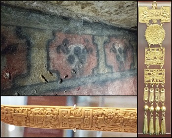
Imagery of the ballgame, ballcourt, and associated rituals can be found throughout Mesoamerica. Imagery that includes the emblematic “I” shape that represents the architectural ballcourt was adopted into Mesoamerican iconography as early as the Formative through the Postclassic period (Houston Reference Houston and Houston1998) and has been reproduced through various media in both 2D and 3D forms (Taladoire Reference Taladoire2012). Examples of 2D ballcourt representations have been found in media such as paint, like the frescos found inside Tomb 3 (Chamber 2) from Atzompa; and in gold and bone, such as jewelry and decorated tools found in Tomb 7 of Monte Albán, both located in the Valley of Oaxaca, amongst others (Figure 1; Caso Reference Caso1969; Robles García et al. Reference García, Nelly, Estrada and Ibarra2014). Other media, such as ceramic and stone, have been used to create small-scale 3D ballcourt representations. For example, ceramic ballcourts have been found in places such as Nayarit, Jalisco, and Colima, in west Mexico, which depict formal constructed ballcourts as the setting of an active ballcourt scene that includes figures of players and spectators alike (Taladoire Reference Taladoire1979, Reference Taladoire2012). Other 3D representations include ballcourt representations carved from portable stone, such as the example from the Templo Mayor of Tenochtitlan in central Mexico. At other sites, relief carvings of ballcourts have been identified in natural rock outcrops fixed in the landscape. In this article, I focus specifically on this type of ballcourt imagery.
Images of ‘I’ shaped ballcourt iconography in various media described in the text. Painted ballcourt iconography from Tomb 3 of Atzompa (upper left); ballcourt iconography in gold (right) and bone (bottom) material from Tomb 7 of Monte Albán. Photographs by the author.

In 2016, members of the Proyecto Arqueológico de Quiechapa (PAQuie) identified 30 carved stone representations of ballcourts in the municipality of San Pedro Mártir Quiechapa during a regional survey project. Based on the available scholarly literature, this is unique in that it is the highest concentration of this type of ballcourt representation in all of Mesoamerica to date. Moreover, it is the only example of carved stone ballcourt representations that has been documented in Oaxaca to date (Taladoire Reference Taladoire2012). Members of PAQuie documented ballcourt representations using traditional methods, such as paper mapping and photography, and these were recorded using image-based 3D methods, specifically, structure-from-motion photogrammetry. The purpose of this article is to report on these findings and offer some hypotheses about the meaning and function of these ballcourt representations. I begin by providing background information about the broader context of where the carved ballcourt representations are located. Then I present information about the ballcourt carvings, including visualizations and quantitative measures. Finally, I discuss the implications of these carvings and propose some possible interpretations.
QUIECHAPA AND THE PRE-HISPANIC CONTEXT
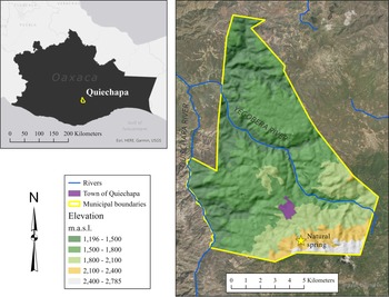
Lush mountains and semi-arid rolling hills characterize a majority of the municipality of San Pedro Mártir Quiechapa (hereafter Quiechapa), located on the northeastern edge of the Sierra Madre del Sur mountain range. A small rural town, also known by the same name, is nestled in the south-central portion of the municipality. The municipality ranges in elevation between 1,100 and 2,781 m above sea level (m.a.s.l.). Higher elevations (mountains) are located in the southern part of the municipality and the topography gradually transitions, continuing north, into a mix of lower-elevation rolling hills and deeply incised arroyos (Figure 2). Due to the physical landscape, the region contains about five different microclimatic zones. The two arid microclimates at lower altitudes (to the north) contain a variety of sturdy foliage and cacti. Conversely, the three microclimates at higher elevations (to the south), typically between 1,800 and 2,781 m.a.s.l., are covered with temperate forests of pine and fir-like trees. The municipality of Quiechapa has two major rivers within its borders, the Quiechapa river and the Yegobera river. The Quiechapa river runs along the western border of the municipality, and the Yegobera river crosscuts the municipality flowing east to west. In addition to the two rivers that flow through the municipality, Quiechapa has a natural spring, or ojo de agua, that flows from the mountains in the southern part of the municipality north into the town. This freshwater source not only provides a year-round supply of clean drinking water to the town, but it is a contemporary ritual site with a deep pre-Hispanic history.
Elevation map of the municipality of San Pedro Mártir Quiechapa, showing contemporary town, rivers, and natural spring. Maps by the author using ESRI's ArcGIS Pro software. Data provided by INEGI and the author.

Settlement Patterns in Quiechapa
The ballcourt carvings were first documented in 2016, when PAQuie conducted a regional settlement pattern survey in the municipality of San Pedro Mártir Quiechapa. During the survey, the PAQuie team carried out a systematic pedestrian survey, covering an area of 99 km2, identifying and documenting 91 archaeological sites, revealing a regional occupation history extending back to the Late Formative period (300 b.c-.–a.d. 200), with continuous occupation in the region through today. While archaeological survey methods did not recover evidence of earlier human settlement in Quiechapa, it is worth mentioning that human occupation in the region likely extends further into the past, as in nearby regions of southern Mexico. Oral history and ethnohistoric data, combined with archaeological survey data, suggest that people living in this region were linked into networks of exchange and were part of the broader sociopolitical, economic, and ideological landscape (Badillo Reference Badillo2017).
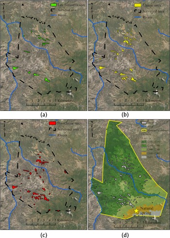
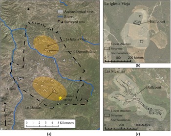
A settlement pattern analysis of the sites and surface materials in the Quiechapa region shows that the settlement system maintained its overall rank-size structure throughout each period during the pre-Hispanic era (Figure 3; Badillo Reference Badillo2019). Subsequent geospatial analysis of the data collected on survey revealed that the region had two relatively large concentrations of pre-Hispanic architecture and surface materials—one located in the southern part of the region, where the present-day town of Quiechapa is situated, and one located in the northern part, just north of the Yegobera river, in lands used for contemporary seasonal agriculture (Figure 4). Both areas of concentration have civic/ceremonial architecture and habitational structures, as well as residential/agricultural terracing. These two concentrations of archaeological sites and materials have been interpreted as two large villages, which served as the primary centers of the local region (Badillo Reference Badillo2019). We refer to these two settlements as Quiechapa (to the south) and Lachiguiryú (to the north). The relationship between these two villages is still unknown. For example, we do not know if these two villages belonged to the same sociopolitical group, or if they were two separate polities. Nonetheless, both areas have clear evidence of settlement beginning in the Late Formative period (300 b.c.–a.d. 200), and have been continuously occupied since then.
Series of settlement pattern maps showing archaeological sites of the region through time. (a) Late Formative sites; (b) Classic site; (c) Postclassic sites; (d) all sites in the region over an elevation surface. Maps by the author using ESRI's ArcGIS Pro software. Data provided by INEGI and the author.

Regional map and sites maps of Quiechapa. (a) Regional map, with orange shading indicating the approximate extents of the two primary settlements (villages) described in the text—Quiechapa in the south and Lachiguiryú to the north; the sites described in the text are also represented; (b) site map of La Iglesia Vieja, showing architectural ballcourt; (c) site map of Las Mesillas, showing architectural ballcourt. Maps by the author using ESRI's ArcGIS Pro software. Data provided by INEGI and the author.

Architectural Ballcourts of Quiechapa
A full-size “I” shaped masonry ballcourt is present at both major settlements in Quiechapa. The ballcourt located in the southern settlement of Quiechapa, at a site called Las Mesillas (QUI-QUI-044), measures 37.5 m long, the playing alley is 7.7 m wide, and is oriented 24 degrees west of north. This ballcourt's eastern lateral mound and eastern portions of the endzones have been partially destroyed by a historic road. Las Mesillas is the largest site in the region, measuring 27.3 ha, and it is situated 400 m north of the natural spring. At the southern portion of the site is a steep and pointed hill, modified with tall stone terraces wrapping around its west, north, and east sides. A patio was constructed on the summit of the hill, surrounded by mounded architecture on the north, east, and south sides, leaving the west side open. The series of terraces covers the hill, regulating access in each direction except the south, where people have modified the natural landscape to form a land bridge, with access to and from the natural spring and the high mountains. The series of defensive terraces continues for 180 m northwest of the summit until the natural topography transitions from steep to more level terrain, in the form of a broad, flat rolling hill. In the flatter (central) portion of the site, there are two rectangular mounded structures followed by the ballcourt (Figure 4c). Adjacent to the northwest of the ballcourt begins an arroyo where people had engineered a series of lama bordo (check dam) terraces filling the arroyo, which are still in use today. To the northeast of the ballcourt is a broad and flat rolling hilltop, with some recognizable pre-Hispanic architecture, mostly in the form of retention terraces that seem to have been used to level the ground. However, contemporary agricultural activity has obscured much surface evidence in this zone; thus, it is difficult to tell if this leveled space was an open plaza or supported other architecture. Surface ceramics found at Las Mesillas suggest Late Formative origins, however, Classic and Postclassic ceramics are also present in the assemblage, suggesting continuous occupation throughout the pre-Hispanic sequence. Interestingly, in the southern portion of the site, the survey team did not recover any Late Formative ceramics on the hill with the tall terraces. Obsidian was found on the surface at collection points throughout the site (including around the ballcourt), except at the top of the terraced hill.
The ballcourt located in the northern settlement of Lachiguiryú, at the site of La Iglesia Vieja (QUI-QUI-032), measures 41.1 m long; the playing alley is 10.8 m wide and is oriented 80 degrees west of north (Figure 4b). A square mound of stone and earth is located 50 m to the north of the ballcourt, measuring 12 m by 12 m and is 2 m tall. A larger square mounded structure, also made of stone and earth, is 136 m to the south. This structure measures approximately 20 m by 20 m and stands 3 m tall. Surface ceramics date the site as early as the Late Formative and it seems to have been occupied through the entire pre-Hispanic sequence. It is likely that there was more architecture nearby; however, contemporary agricultural activities make it difficult to discern much from the surface. The site of La Iglesia Vieja, measuring 5.25 ha, is one of a few sites that make up the Lachiguiryú settlement, and because of the type of architecture present there, it is considered the civic/ceremonial center of the broader settlement.
One other architectural feature located on the northern end of the modern town of Quiechapa has been identified as a possible ballcourt as seen from a distance; however, as we were not permitted to walk this parcel of land, we could not confirm this with further evidence.
THE CARVED STONE BALLCOURTS OF QUIECHAPA
The carved stone representations of ballcourts were identified at two different sites in the region. A group of 22 carvings is located at the site of El Gentil (QUI-QUI-008), and a smaller group of eight carvings is located at El Derrumbadero (QUI-QUI-036; Figure 4). In total, we documented 30 ballcourt carvings in the Quiechapa region during our archaeological survey.
El Gentil (QUI-QUI-008)
The El Gentil site is located on the western side of the municipality, about 1.5 km west of the Quiechapa settlement's ceremonial center (Figure 4). The surface ceramics at the site show continuous occupation from the Late Formative to the Postclassic period. Two tombs were identified just west of the summit of the hill located on the eastern side of the site. Although the tombs and surrounding structures are largely destroyed from erosion and looting, we identified at least two patios surrounded by architecture on three sides, north, east, and south.
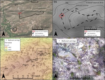
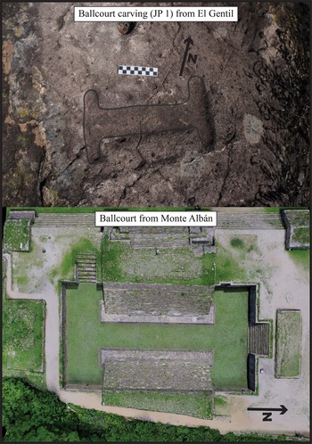
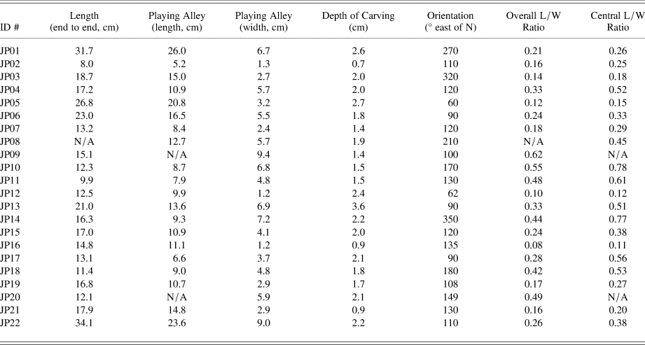
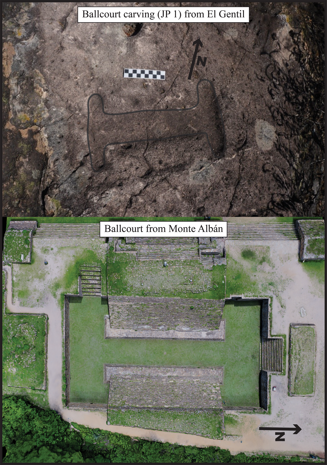
The site contains rock carvings at three locations, the first of which is adjacent to the patio of one of the architectural complexes at the top of the hill. However, this set of carvings does not contain ballcourt imagery. The other two groups of rock carvings are located on the western sector of the site (Figure 5b). The majority of the carvings located at El Gentil are concentrated on a low hilltop, with visible bedrock exposures on much of the surface (FIgures 5c and 5d). These rock outcrops are the context for a palimpsest of carvings from the pre-Hispanic, Historic, and contemporary periods based on the iconography. Iconographic evidence that corroborates this long-time span includes carvings that relate to pre-Hispanic worldviews, carvings that depict people riding horses, and carvings that contain contemporary evidence of carving. The carvings range from anthropomorphic to zoomorphic and geometric in design. It is amongst this collection of carvings that 18 small-scale representations of ballcourts, also known as maquetas, were identified (Figure 6). About 350 m to the northeast of the 18 ballcourt carvings is another bedrock exposure on a flat area on the side of a hill that contains four more ballcourt carvings. Unlike the other rock outcrops on the low hilltop, this rock outcrop does not have evidence of other carvings beyond the ballcourts. In total, 22 of these carved stone ballcourt representations were identified at El Gentil. Unique identification numbers are shown in Figure 5 and Table 1.
Map series of the site of El Gentil. (a) Oblique angle of El Gentil (centered) illustrating the topography; (b) site map of El Gentil, showing elevation contours, and area mapped using UAV imagery delineated in red; (c) UAV map showing digital surface model of the hilltop with natural rock outcrops that contain the ballcourt carvings; (d) zoomed extent of map (c), extent indicated on map (c) with black outline. Maps by the author using ESRI's ArcGIS Pro software. Data provided by the author.

(a) Image of a ballcourt carving from Quiechapa; photograph by the author. (b) Image of the masonry ballcourt located on the northeast corner of the Main Plaza of Monte Albán for comparison. Image provided by the Monte Albán Digital Archaeology Project.
Measurements of 22 ballcourt carvings from the site of El Gentil.

El Derrumbadero (QUI-QUI-036)
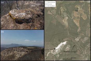
The site El Derrumbadero is part of the Lachiguiryú settlement (Figure 4). Ceramic evidence suggests that occupation of the site begins in the Classic period and continues through the Postclassic period; however, nearby sites that are also part of broader Lachiguiryú settlement have ceramic evidence that dates back to the Late Formative, suggesting that El Derrumbadero was likely also occupied in the Late Formative. The site is located along the top of a unique topographic feature, a long, crescent-shaped ridge, and serves as part of a natural southern boundary of the Lachiguiryú cluster area (Figure 7). There is a tall cliff on the south side of the site, left over from a major erosional event. The site is only 330 m south of the site La Iglesia Vieja, located at the heart of the Lachiguiryú settlement area containing civic/ceremonial architecture, such as a formal ballcourt and large mounds. From the high ridge of El Derrumbadero, the viewshed spans the entire northern expanses of the Quiechapa municipality and into the neighboring municipality of Santa María Zoquitlán. It also includes a view to the south, southeast, and west, which includes the present-day town of Quiechapa, the large mountains that border the south and southeast of the municipality, and the neighboring municipality of San José Lachiguirí.
The site of El Derrumbadero. (a) The exposed bedrock where the carvings were identified; (b) photo taken from the location of the exposed bedrock towards the west, showing the cliff described in the text; (c) site map of El Derrumbadero, indicating where the stone carvings are found. Images provided by the author. Map provided by the author using ESRI's ArcGIS Pro software. Data provided by the author.

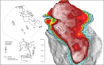
A large rock outcrop located along the top of the tall cliff on the southern edge of the site has extensive evidence of modification. The rock carvings are thought to represent small-scale models of architectural features, including mounded structures, sunken patios, canals, and ballcourts (Javier Urcid, personal communication 2017). Since most of the carvings are on the top surface of the rock outcrop, exposure to the elements has slowly been eroding the carvings. Eight ballcourt representations were identified on the top of this rock (Figure 8). Evidence of what seem to be more ballcourt carvings is present; however, we could confidently identify only eight of them.
(a) Illustration and (b) 3D model of the top-down view of the stone carvings located at El Derrumbadero. The illustration was digitized from a graph paper map made in the field. The 3D model was manipulated in CloudCompare to show elevation differences. Black rectangles denote ballcourt carvings. Note the differences between the in-field drawing and the 3D model. Images provided by the author using Adobe Illustrator and CloudCompare software. Data provided by the author.

METHODS OF DOCUMENTATION
To record carved stone features in Quiechapa, we used in-field sketches and graph paper mapping, photographs, and structure-from-motion (SfM) photogrammetry (both terrestrial and aerial) for documentation methods. SfM photogrammetry is an image-based technique that uses 2D photos to generate digital 3D representations of real-world phenomena (De Reu et al. Reference De Reu, Plets, Verhoeven, De Smedt, Bats, Cherretté, De Maeyer, Deconynck, Herremans, Laloo, Van Meirvenne and De Clercq2013). Essentially, a series of 2D images are taken of an object from multiple angles, loaded into SfM photogrammetry software, and by processing the imagery with specialized algorithms, the 3D geometry of the object can be reconstructed virtually. In addition to reconstructing the 3D geometry, SfM techniques have the added benefit of recording the visually observable aspects of the object as a photorealistic texture. When documenting using SfM, the “object” can range in scale from small artifacts, to larger features (i.e., excavations, architecture), to entire sites and landscapes (Badillo et al. Reference Badillo, Myers and Peterson2020; Borrero and Stroth Reference Borrero and Stroth2020; Porter et al. Reference Porter, Roussel and Soressi2016; Sapirstein Reference Sapirstein2016). Using 3D documentation methods in archaeology has become more mainstream in the last ten years, and the finer details of this method have been described in depth in the archaeological literature elsewhere (De Reu et al. Reference De Reu, De Smedt, Herremans, Van Meirvenne, Laloo and De Clercq2014; Douglass et al. Reference Douglass, Lin and Chodoronek2015). However, it is important to note that when done correctly, a major benefit of using SfM is that you can apply real-world scale to the digital 3D models, making them measurable. At the site of El Gentil, which contains the majority of the ballcourt carvings, we also used an unmanned aerial vehicle (UAV, or drone) to map the broader context of the natural rock outcrops where the carvings are located. Using the same SfM methods, the UAV imagery was used to produce a digital surface model (DSM) and orthophoto that are usable in GIS software.
For this project, we used a Sony NEX-5N and a Canon EOS M50 for all terrestrial photography, both standard 2D photographs and the production of scale 3D representations. The Sony NEX-5N is a mirrorless camera that has a 16.1 megapixel (MP) APS-C format CMOS sensor (23.4 × 15.6 mm) with an 18–55 mm f/3.5-5.6 OSS lens. The Canon EOS M50 is a mirrorless camera that has a 24.1 MP APS-C format CMOS sensor (24.2 × 14.8 mm) with a 15–45 mm f/3.5-6.3 IS STM lens. For all aerial photography, we used a DJI Phantom 2 (v.2) as the UAV platform to aid with photocapture, equipped with a GoPro HERO4 Black digital camera. The GoPro HERO4 Black has a 12 MP CMOS sensor (1/2.3 inch) with a wide-angle lens. To georeference the DSM and orthophoto, we used differential GPS equipment (Emlid Reach +). The software Agisoft Metashape Professional (version 1.6) was used for all processing of imagery to generate 3D models of the ballcourt carvings, the DSM, and orthophoto. All processing was done on an HP Z-book with an Intel® Core™ i7-7820HQ 2.90 GHz processor, 32 GB of RAM, and an NVIDIA Quadro P4000 graphics card.
For successful SfM photogrammetry, photos must be taken of an object from all angles, which generates a series of photos, known as a photoset, which is used to process into a digital 3D representation. All of the photosets were processed using the same workflow in Agisoft Metashape, where they were rendered, assigned scale, and virtual measurements were made. From Agisoft Metashape, the 3D representations were exported as *.obj files and imported into CloudCompare for further visualization and analysis.
VISUALIZATION AND QUANTITATIVE MEASURES AT EL GENTIL
For the 22 ballcourt carvings at El Gentil, we were able to use the digital 3D models for both enhanced visualization and analysis. While the eight carvings at El Derrumbadero were 3D modeled and can be used for visualization, their measurements are not included in the analysis as they were not documented with the same high-precision methods as the carvings at El Gentil. All 3D models produced from both sites are available for visualization through links in the Supplementary Material and can be found at the project's Sketchfab page (https://sketchfab.com/PAQuie/collections/ballcourt-carvings-of-quiechapa).
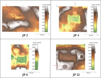
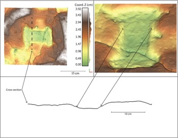
There were some subtleties that were not recognized in the field and that are not discernable in 2D photographs that came to light during visualization of the digital 3D models. For example, one ballcourt carving, JP4, has evidence of anthropogenic modification in the area surrounding the ballcourt in the form of a large circular depression (Figure 9). In other instances, ballcourt carvings JP2, JP8, and JP22 have circular depressions adjacent to the courts themselves. Additionally, subtle benches can be seen carved lengthwise along the interior at the base of the apron (sloped walls; Figure 10). In the case of the site of El Derrumbadero, the enhanced visualization of the 3D model proved fruitful. In the field, only five ballcourt carvings were identified. In the lab, three more were identified by manipulating the 3D mesh (Figure 8).
Relief models of selected ballcourt carvings highlighting subtle features identified during visualization of the 3D models. Red arrows show depressions adjacent to ballcourt iconography. Black arrow shows the larger depression encircling JP4. Images by the author using CloudCompare. Data provided by the author.

Relief model and cross-section of JP4, highlighting the possible benches mentioned in the text. Images by the author using CloudCompare. Data provided by the author.

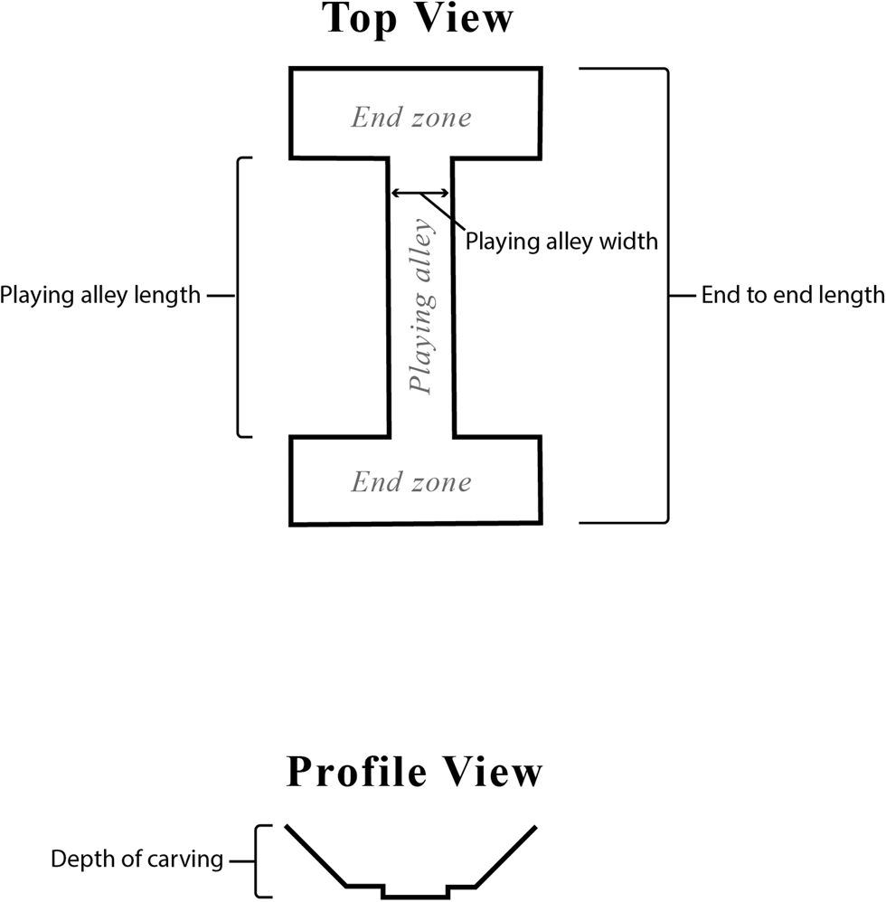
Scale was assigned to the digital 3D models from El Gentil, which allowed for precise measurements. We used both traditional and specialized photogrammetry scale bars during the SfM documentation procedures. (Hand-calibrated scale bars were obtained through Cultural Heritage Imaging. Scales can be found at http://culturalheritageimaging.org/What_We_Offer/Gear/Scale_Bars/index.html.) In the cases when we used traditional scale bars, I had to manually register control points in Agisoft Metashape. This sacrificed some precision, as the control points were not automatically registered through the software. However, internal precision was still submillimeter, which I feel is an acceptable range of error. I used virtual tools to measure standard dimensions for the digital 3D models. The dimensions that were measured and recorded of each ballcourt carving were based on extant literature on the topic (Kowalewski et al. Reference Kowalewski, Feinman, Finsten, Blanton, Scarborough and Wilcox1991; Stoll Reference Stoll2018). Over the years, these carvings have deteriorated due to natural and anthropogenic causes, making it difficult, at times, to locate secure points from which to make measurements. Thus, because of the current state of some of the carvings, I was unable to get a confident measurement for certain dimensions. Figure 11 shows a diagram indicating selected standard dimensions that were recorded, and Table 1 shows those measurements tabulated for the ballcourt carvings at El Gentil.
Diagram showing the standard measurements taken for each of the ballcourt carvings using virtual tools in Agisoft Metashape. Diagram by the author using Adobe Illustrator.

Of the ballcourts available for virtual measurement at the site of El Gentil (n = 22), we found that the carvings had an average length of 17.3 cm (min. 8.0 cm, max. 34.1 cm), measured from end to end by the longest axis. The average width of the playing alleys is 4.7 cm (min. 1.2 cm, max. 9.4 cm). The average depth of the carvings measured from the floor of the playing alley to the top of a lateral mound is 1.9 cm (min. 0.7 cm, max. 3.6 cm).
Proportions are another way to characterize the dimensions of the carvings, as a ratio of length and width. I present these as ratios following Stoll (Reference Stoll2018:536–541), who uses both overall and central alley lengths to calculate this ratio. The overall length/width (L/W) ratio is calculated using the end-to-end length of the ballcourt carving and the width of the playing alley. The central alley L/W ratio is calculated using the length of the playing alley (excluding the endzones) and the width of the playing alley. The average overall L/W ratio equals 0.29, and the average central alley L/W ratio equals 0.38. The orientations of the ballcourt carvings do not seem to be patterned in any particular way and do not seem to have been aligned to a specific cardinal direction.
When comparing the dimensions of ballcourt symbols documented using 3D methods at El Gentil, there seems to be a wide range of sizes. This variation may suggest that there was no standard length and width for production. However, there seems to be a tendency for designing ballcourt carvings that have lower L/W ratios, suggesting that the standard or preference was to design these carvings to be generally more elongated and rectangular rather than square.
CARVED STONE REPRESENTATIONS OF BALLCOURTS IN BROADER MESOAMERICA
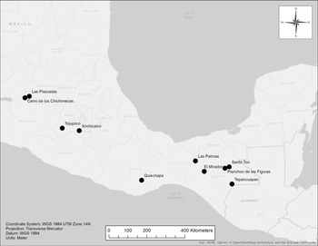
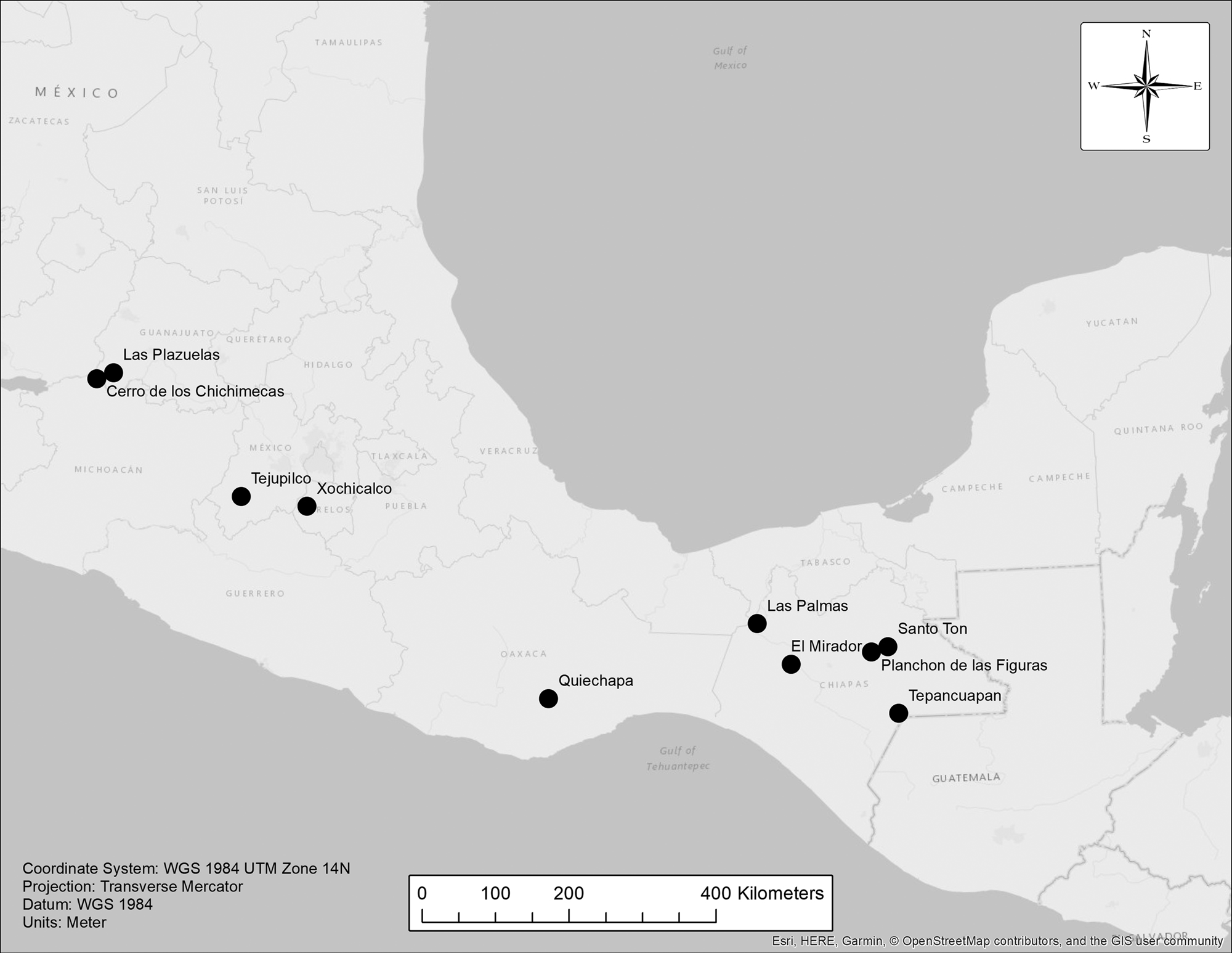
Quiechapa is not the first place where archaeologists have found ballcourt representations carved in natural rock outcrops in Mesoamerica; however, it is the first time it has been documented within the state of Oaxaca. Taladoire tabulated all known 2D and 3D ballcourt representations in his study (2012:Figure 3). Of these, 12 sites were categorized as having petroglyphs that represented ballcourts (Taladoire Reference Taladoire2012:22). When mapping the major sites referred to in his article, one may notice the large geographic extent in which archaeologists have documented these elements, running from west Mexico (Michoacan and Guanajuato) to southeastern Mexico (eastern Chiapas; Figure 12). It is not surprising that the spatial extent of these ballcourt carvings would be as expansive as the distribution of the constructed ballcourts used for ballgame rituals, mirroring their spread over the vast culture area of Mesoamerica. However, one may also notice the large space in southern Mexico where there do not seem to be any ballcourt carvings. This anomaly is not as significant as it may seem at first glance for a couple reasons. First, traditional regional-scale survey procedures and protocols, while systematic, are not as intensive as surveys conducted at smaller scales. Additionally, the primary goal and focus of a settlement survey is often to document settlement, built structures, and surface scatters. I do not suggest that survey routines excluded the documentation of elements such as carved stone as they were identified in the field, but simply that they may have been missed by the surveyor. The ballcourt carvings are small (~10–30 cm long) and are difficult to discern from a few meters away, as they blend into the natural stone and have been severely eroded by natural processes. Second, this map includes evidence of ballcourt carvings from accessible scholarship, including published works and some field reports. It may be that there are other sites in the region where this type of carved stone element has been documented, but their existence has yet to be disseminated more widely.
Map showing locations of other sites in Mesoamerica that contain evidence for ballcourt carvings in natural rock outcrops. Note the wide gap in data in southern Mexico. Map by the author using ESRI's ArcGIS Pro software. Data provided by the author.
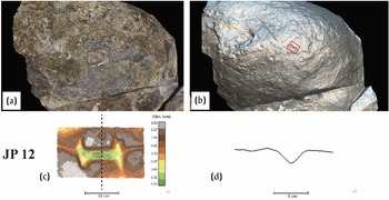
Images of JP 12 from El Gentil: (a) image of 3D model of outcrop with photorealistic texture; (b) image of 3D model of outcrop with metallic texture to show morphological changes; (c) relief map of JP 12 showing canal leading in and out of ballcourt carving; (d) cross-section of JP 12. Images by the author using CloudCompare and Adobe Illustrator. Data provided by the author.

I posit that these carved stone elements likely exist in other places besides Quiechapa within Oaxaca and broader southern Mexico. Throughout southern Mexico, there is much evidence of constructed ballcourts that have the iconic “I” shape in the region, and I believe it to be unlikely that the carved representations would not be present as well. The overall fit of the spatial extent of known carved stone elements with the wide distribution of constructed ballcourts leads me to believe that the gap is likely due to a lack of documentation or reporting. Furthermore, other evidence of “I” shaped ballcourt representations recorded at sites such as Atzompa (i.e., painted murals) and Monte Albán (i.e., jewelry and bone from Tomb 7), which are located within the geographic region of southern Mexico, confirm that people there used these elements symbolically as they were used in other places.
Taladoire (Reference Taladoire2012), analyzing ballcourt representations more broadly, discusses general geographic trends for two- and three-dimensional ballcourt representations. He posits that in western Mexico, and the central and southern highlands, ballcourt representations are similarly created, with a plan-view perspective, while those located in eastern Mexico, in which he includes Veracruz and the Maya region, are represented in profile view, in addition to plan-view perspectives. However, when it comes to ballcourt representations carved in natural rock outcrops, it seems that they are represented similarly throughout, from a plan-view perspective forming a capital “I”.
Understanding the chronology of ballcourt representations carved in rock outcrops has been challenging. At the site of Ixtapan, Limón Boyce (Reference Limón Boyce, Schoenberg, Ortiz Díaz and Santos Ramírez2008:265) dates the maqueta to the Late Classic to Epiclassic, in line with the site's apogee; however, he did not seem to use any additional dating methods to confirm that supposition. In discussing the chronological placement of the maquetas at Santo Ton, Esponda Jimeno and colleagues (Reference Jimeno, Manuel and Whiting1996:411) state that they are difficult to date as they have not been found in any excavations within datable contexts. Taladoire (Reference Taladoire2012:24), understandably, gives a broad range to the appearance of ballcourt representations in both 2D and 3D media, estimating any time between the Formative and Postclassic periods, mirroring the appearance and continued use of actual constructed ballcourts in Mesoamerican society. In southern Mexico, there is evidence of the construction of ballcourts in the Early Formative period at sites such as Etlatongo (Blomster and Chávez Reference Blomster and Chávez2020) and Paso de la Amada (Hill and Clark Reference Hill and Clark2001), although these examples lack the iconic “I” shape. At least a thousand years later, during the Terminal Formative, after around 100 b.c., people at Monte Albán constructed the “I” shaped ballcourt located on the northeast corner of the Main Plaza (Blomster Reference Blomster2012:8022; Winter Reference Winter, Ruiz, Ponce de León and Martínez2001:288). It was during this time that we see evidence for the proliferation of this particular type of court in the region of southern Mexico.
As carved representations of ballcourts have been identified in the field, there has been some speculation as to their purpose and function. It is not my intention here to provide a full description and review of all of the literature on ballcourt representations; however, I wish to draw on some salient cases that should help to convey how other scholars have thought about these carved elements.
Scholars have written about stone ballcourt carvings as being part of a broader category of small-scale architectural relief models, or maquetas, which represent real-world proportions or reflect architectural styles and characteristics (Castañeda López Reference Castañeda López2000; Cook de Leonard Reference Cook de Leonard1955:174; Esponda Jimeno et al. Reference Jimeno, Manuel and Whiting1996; Litvak King Reference Litvak King1965; Moguel Cos and Sánchez Correa Reference Moguel Cos and Correa1989; Schoenberg et al. Reference Schoenberg, Diaz and Ramirez2008). For example, at the site of El Cobre, later written about as the site of Las Plazuelas, in Guanajuato, Mexico, Moguel Cos and Sánchez Correa (1989) write about a specific rock outcrop with carved architectural elements (i.e., plazas, mounded structures) that they believe to faithfully represent a nearby architectural compound. Castañeda López (Reference Castañeda López2000) later writes about carved maquetas in three other rock outcrops at the site of Las Plazuelas, which include ballcourt representations, in addition to other architectural elements. While these carvings contain clear evidence of Mesoamerican architectural characteristics, he questions the purpose of their creation, wondering if they are related to actual architecture in nearby or distant places, if they represent symbols of a shared identity of place, such as a place of origin, or if they functioned more as blueprints to aid in design and construction. Interestingly, Castañeda López (Reference Castañeda López2000:79) does point out that while large-scale constructed ballcourts exist in the broader region, there are very few in proportion to the number of registered sites. Nevertheless, the carved stone maquetas, curiously, include ballcourts.
While recognizing the connection between carved stone representations and actual architecture in Mesoamerica, other hypotheses go beyond designing or recording real-world built environments. For example, at the site of Ixtapan, Tejupilco in the state of Mexico, there is uncertainty if the layout of the small-scale architectural representations carved in natural rock correspond to an actual architectural plan or if people were reproducing architectural elements that have a special meaning (Hernández Rivero Reference Hernández Rivero2009:26; Limón Boyce Reference Limón Boyce, Schoenberg, Ortiz Díaz and Santos Ramírez2008:259). At Ixtapan, the carved stone ballcourts are part of a larger carved architectural complex that covers the varied topography of a large rock outcrop, which has elements on various levels. Limón Boyce (Reference Limón Boyce, Schoenberg, Ortiz Díaz and Santos Ramírez2008:260) does assert that the small-scale representations seem to have actual large-scale counterparts within the broader site, reflecting specific architectural forms, proportions, and characteristics, and thus can be considered a maqueta in this respect. However, the representation as a whole does not reflect any part of the site itself. Limón Boyce (Reference Limón Boyce, Schoenberg, Ortiz Díaz and Santos Ramírez2008:265) also documented evidence of small cavities, or holes, in close proximity to nearly all of the carved stone architectural representations. In the end, he describes the rock outcrop with carvings at Ixtapan as a “monumento votivo,” or votive monument, which he suggests might imply that the carvings could have served as a locus for votive rituals. Moreover, Taladoire (Reference Taladoire2012:25) suggests that it is possible that the carvings at Ixtapan, Tejupilco may have cosmological significance in that it has a sunken patio in the center and the four ballcourts are distributed in the four cardinal directions.
Over 875 km east/southeast of Ixtapan, at the site of Santo Ton, Chiapas, Mexico, archaeologists have documented carved stone architectural representations that include plan-view ballcourts. Esponda Jimeno and colleagues (Reference Jimeno, Manuel and Whiting1996:396–408) write about the various small-scale representations of architecture, which they also refer to as maquetas, which have been documented at the site. They classify the maquetas at Santo Ton into two groups, unitarios or conjuntos (singular or grouped), in that some maquetas seem to be of a single architectural feature, while others are complexes of many architectural features (Esponda Jimeno et al. Reference Jimeno, Manuel and Whiting1996:411). There are four ballcourt representations carved into stone at Santo Ton. One is carved into a smaller, more portable stone that was eventually lost, while the other three are part of a much larger stone maqueta, known as Maqueta 3, that includes a representation of an entire civic-ceremonial or administrative center. As in the cases described above at Las Plazuelas and Ixtapan, the architectural plan and elements therein, represented in Maqueta 3 of Santo Ton, seem to have proportions, elements, and characteristics of actual constructed architecture. Esponda Jimeno et al. (Reference Jimeno, Manuel and Whiting1996:403) suggest that the creators of Maqueta 3 “knew perfectly well the function and spatial relationships between the various types of buildings and public spaces of this kind of [civic-ceremonial] center” (translated from Spanish by author). Nevertheless, according to Esponda Jimeno and colleagues (Reference Jimeno, Manuel and Whiting1996:403), there does not seem to be evidence of any actual counterpart within the archaeological site of Santo Ton or in the broader region. Similar to Limón Boyce's monumento votivo hypothesis, Esponda Jimeno et al. (Reference Jimeno, Manuel and Whiting1996:403–404) posit that the maqueta was part of an altar of a shaman who would use it to invoke the various gods associated with different structures represented in the stone maqueta, including ballcourts, thus functioning as a locus for ritual. Interestingly, they note that Maqueta 3 is not located within the actual site's sacred precinct, but rather away from public spaces of the site and suggest that this locus implies that rituals performed here would have been private or particular.
In addition to the aforementioned cavities, or holes, like those found at the site of Ixtapan, at times, other elements that are found associated with plan-view stone ballcourt representations are channels or grooves. This is the case at sites such as Planchón de las Figuras (Houston Reference Houston and Houston1998:Figure 22), Las Palmas (Navarrete et al. Reference Navarrete, Lee and Rhoads1993:Figures 50 and 51), Santo Ton, and Tepancuapan (Navarrete Reference Navarrete1984:Figures 89 and 90). Houston (Reference Houston and Houston1998:359) writes about how each of these sites contains carved representations of ballcourts, “with channels grooved for the flow of water or some other fluid.” Specifically, he mentions that at the site of Planchón de las Figuras, the “I” shaped depression could have been filled periodically by water from a nearby natural water source. Other scholars have also written about the possibility of small depressions, channels, and other symbols carved into stone as being used to circulate or collect water during rainy seasons (Zimbrón Romero Reference Zimbrón Romero1992:62). Blood is a possible candidate for the “other fluid” mentioned by Houston. Ruiz de Alarcón (Reference Ruiz de Alarcón2007 [1629]:38), a seventeenth-century priest writing about indigenous ritual practices, describes certain rituals during which a priest would have people spill blood into small cavities that they had made in stone.
The idea that water and blood are considered sacred and are symbols that are central to Mesoamerican cosmology is well-established in the literature (Carpio Rezzio Reference Carpio Rezzio2018; González Pérez Reference González Pérez2019; Taube Reference Taube, Renfrew, Morley and Boyd2017). Taube (Reference Taube, Renfrew, Morley and Boyd2017:265) writes about blood within Mesoamerican thought, stating, “our bodies are intensely refined and distilled microcosms of the world, with our blood metaphorically compared to the life-giving water of rain as well as streams and pools.” If we consider the symbolic aspects of the Mesoamerican ballgame, such as death, fertility, and renewal, together with the uses of water and blood within the context of miniature ballcourt carvings, it is logical that the symbolism of the ballcourt carving is closely related, if not parallel, to that of the constructed ballcourt.
In sum, many have speculated on the purpose of carved ballcourt representations. In some cases, the ballcourt carvings are one component of many small-scale representations of architectural features that comprise a larger complex, which may have helped with construction or urban planning and may have been an expression or memory of a place that contributed to identity making. In other cases, the ballcourt carvings and their rocky setting seem to be loci for ritual performances related to death, life, fertility, and renovation. I suggest that the function and meaning of the carved stone ballcourt representations would have been as diverse as actual ballgame styles, rules, and rituals, dependent on the community of people and their setting, and how they negotiated broader Mesoamerican worldviews locally.
DISCUSSION OF THE BALLCOURT REPRESENTATIONS OF QUIECHAPA
Assuming that formal masonry “I” shaped ballcourts inspired the creation and use of these ballcourt carvings, and not the other way around, it seems logical that these carvings are a later development that came after “I” shaped ballcourt architecture had been established. These particular courts begin to appear in southern Mexico in the Terminal Formative period. Sociopolitical transformations occurring in large urban centers like Monte Albán had a widespread effect on architectural styles throughout the macroregion, including the Sierra Sur where Quiechapa is nestled in the northern foothills, about 80 km away. According to ceramic and architectural similarities documented on archaeological survey of Quiechapa, it is certain that Quiechapans had been interacting with people from the Oaxaca Valley as early as the Late Formative. Formal ballcourts were constructed in Quiechapa at the centers of the two primary settlements of the region. I assume this would have occurred sometime after the building of the ballcourt at Monte Albán (ca. 100 b.c.). Both El Derrumbadero and El Gentil had evidence of occupation extending back to the Late Formative and were continuously occupied through the Postclassic based on surface ceramics. While the broader context of the appearance of “I” shaped ballcourts in southern Mexico would suggest that the architectural ballcourts and carved ballcourts of Quiechapa were created sometime after 100 b.c., further research will still be required to chronologically pinpoint when these features were created.
The ballcourt carvings at the site of El Derrumbadero are embedded into a broader miniature architectural complex and are found together on one large natural rock outcrop. Upon close inspection of the digital 3D representation of the carvings at El Derrumbadero, one can see the various depressions (sunken patios and ballcourts) associated with channels and grooves that may have drawn liquid away from the depressions as they filled. Most of the depressions are on the level surface of the natural rock and the channels seem to begin on the top surface and wrap around the sides. This would channel the liquid, presumably blood or water, from the flat surface of the rock outcrop to the ground.
The ballcourts at the site of El Gentil differ in that they appear on various rock outcrops at two locations within the same site. The majority (seven out of ten) of the rock outcrops contain two or more ballcourt carvings. Other carved elements accompany some ballcourt carvings at El Gentil, such as circular depressions or channels. For example, JP12 has clear evidence of channels leading into one side of the ballcourt and out the other (Figure 12). In the case of JP13 and, to a lesser extent, JP12, nearby carved elements may represent different types of architecture, as in the case of El Derrumbadero.
As mentioned in the discussion above, other scholars have speculated about the use and meaning ascribed to these ballcourt carvings. In the case of El Derrumbadero, the ballcourts seem to be a part of a larger maqueta, or plan-view map, of a miniature settlement, as it includes elements that seem to represent mounds and sunken patios. However, there are other elements, like channels and grooves present as well. With the exception of JP13, the carvings at El Gentil do not seem to be part of a broader plan-view maqueta; rather, they are associated with elements such as channels and depressions. Both sites share this trait in particular.
When evaluating the spatial context in which we find the ballcourt carvings of El Derrumbadero and El Gentil, there may be some broader logic to their position in the landscape. Rocky outcrops exist throughout the Quiechapa region; however, evidence of these carved symbols seems to be limited to the outcrops at these two sites. The ballcourt symbols at El Derrumbadero are located on a prominent hilltop in between two large settlements that dominated the Quiechapa settlement system during pre-Hispanic times. From this vantage point, one can see both primary settlements in the region, separated by a natural boundary, the Yegobera river.
The carved stone ballcourts at El Gentil may also be located between settlements, as they are located at the far northwestern edge of the Quiechapa settlement; however, this cannot be confirmed without survey data further to the west. The survey boundary coincides with the natural boundary created by the Quiechapa river and ends just to the west of El Gentil. Based on contemporary settlement patterns, it is likely that there is another large pre-Hispanic settlement on the other side of the river. But again, this is left to be proven archaeologically.
Possibilities for Meaning and Use
If we assume that the stone ballcourt carvings are closely related to the meaning and function of constructed ballcourts, we may begin to speculate as to what they may have meant to people in the past and how they may have been used. The ballcourt carvings at El Derrumbadero and El Gentil may have been loci for ritual practices pertaining to fertility, death, and renewal. The presence of canals and small depressions, suggesting that water or blood may have been used as part of these rituals, also links this practice to the same themes. Scholars have written about the hipball game's relationship to the movement of celestial bodies, the daily and yearly cycle, and seasonality (Cohodas Reference Cohodas1975; Gillespie Reference Gillespie, Scarborough and Wilcox1991). With this in mind, we can imagine ritual specialists coming out to these locations in the landscape and performing rituals on specific occasions, likely during prescribed times of the year, in order to maintain the agricultural cycle, or even during times outside of the normal cycle, as needed. The ballcourt carvings themselves, the adjacent depressions, or canals, may have been filled by a liquid, as suggested by other scholars. This could have been accomplished through ritual bloodletting, natural rainfall, or by carrying water from a nearby natural water source. In Quiechapa's case, this could have been water brought from the natural spring, or the rivers that run in close proximity to the ballcourt carving sites. From my own research, as well as that of other scholars (González Martínez Reference González Martínez2021:166–204; Victoria-Martínez Reference Victoria-Martínez2020), the natural spring and its water are considered sacred today, and were also considered sacred in the pre-Hispanic past. The rituals themselves, who and what they involved, would likely have been dependent on the occasion. Thus, while these rituals may have been performed by one person, they may also have been part of a communal practice that included non-specialists as well.
Gillespie (Reference Gillespie, Scarborough and Wilcox1991:341) has argued that constructed ballcourts located at the edges of sociopolitical territories may have been intended “to emphasize the distinction between diverse, probably competitive ethnic groups”. She argues that they would have served as mechanisms for social and physical boundary maintenance when built in these spatial contexts. Furthermore, Ringle (Reference Ringle, Grove and Joyce1999:209–210) echoes Gillespie's argument, stating that ballcourts are often found in locations that mediate spaces, along roadways (sacbeob) connecting cities, where roadways articulate with large centers, or at entrances to outlying architectural compounds. If we think of where these ballcourt carvings are situated in the sociopolitical landscape, it is possible to conceive of these sites as marking boundaries between places and/or social groups. If this is true, these may also be sites for maintaining intercommunity relationships.
Procession was a major component of Mesoamerican ritual life, and ritual procession may have been related to ballgame rituals (Fox et al. Reference Fox, Ashmore, Blitz, Gillespie, Houston, Leyenaar, Marcus, Moore, Urban and Schortman1996:486; Orr Reference Orr, Koontz, Reese-Taylor and Headrick2001, Reference Orr2003). Today, people in Quiechapa have processions, like many towns in the region. In 2016, I was present for a dedication ceremony of a newly constructed water reservoir in the seasonal lands of Lachiguiryú, near the pre-Hispanic settlement previously mentioned. This was a major event in the land use history of the town in that they now had the ability to pipe water from the natural spring to the northern part of the municipality, transforming seasonal land to land that can be cultivated year-round. The ceremony was an all-day affair, with a formal dedication ceremony that included blessings and speeches, accompanied by music played by the town's band. The ceremony was followed by a procession of the community to a chapel where there was a feast and a rodeo (see https://youtu.be/dDUIHjeafAA to view the ceremony and procession).
Royce (Reference Royce2011:145–146), writing about contemporary Isthmus Zapotec death rituals, writes that the Zapotec of the city of Juchitan are a people dedicated to procession. She writes that procession today is a way for a person to express changes in status within their community. In the case of the death of a community member, the act of procession is to help facilitate the person's journey from the world of the living to the world of the dead, a metaphysical transformation. In both the examples from Quiechapa and Juchitan, procession facilitates a transformation of sorts. Royce adds that participation in processions also functions to demonstrate one's commitment to important occasions and the community at large. She later discusses the pre-Hispanic roots of contemporary procession, saying, “The tradition goes back to ancient Mesoamerica when the Zapotec at their great ceremonial sites would have processions in honor of the gods, winning a battle, celebrating a particular seasonal ritual, and burying their leaders” (Royce Reference Royce2011:145). In the context of Mesoamerican ballgame rituals, Orr (Reference Orr2003) asserts that procession was an integral part of ballgame rituals through her interpretation of ballgame-related iconography. While in her article Orr specifically focuses on the Mesoamerican handball game rather than the hipball game, I think it is logical that procession was also a part of the latter.
If we assume that procession was part of rituals pertaining to the carved ballcourt representations, as it was with the ballgame, we can begin to imagine what the scene may have looked like in the past. On certain occasions, people from Quiechapa may have walked together as a community from an origin (i.e., the masonry ballcourt in the village, the natural spring, or a high mountain summit) to the carvings at either El Derrumbadero or El Gentil to perform rituals. These processions and performances may have marked special occasions, changes in status of individuals, or may have been a part of the yearly agricultural/ritual cycle. Participation in these processions and performances would have been moments when people could demonstrate their commitment to the community and to these important occasions.
While trying to imagine the original social context of these ballcourt carvings, one asks the questions: Why not just perform these rituals in the full-size ballcourts? How would rituals differ between these contexts? The existence of both the miniature and full-sized ballcourts certainly implies differences in use, but the particulars of those differences are still left to learn. In the end, the material evidence to support the scenarios mentioned in the latter part of this discussion is still lacking and much of it is abstraction; however, it is my hope that this can be a point of departure for other scholars.
CONCLUSION
In this article, I have reported on the small-scale ballcourt carvings, sometimes called maquetas, identified during the archaeological survey of the municipality of San Pedro Mártir Quiechapa in 2016. The 30 carvings, located at the sites of El Gentil (n = 22) and El Derrumbadero (n = 8), were recorded using both traditional and digital 3D methods. Structure-from-motion photogrammetric techniques allowed me to revisit, measure, visualize, and analyze these features using virtual tools.
In reviewing the available literature on stone ballcourt carvings, I show the geographic areas where other archaeologists have identified similar features and the range of interpretations or hypotheses of their function and meaning. Based on other scholars’ interpretations of similar carvings and what we know about the meaning/function of the related hipball game ceremonies, I suggest that the carvings in Quiechapa were likely loci for ritual performance pertaining to fertility, death, and renovation.
In the discussion, I offer some thoughts about the ritual performances, speculating when they may have occurred, who may have been involved in them and how they were used, and how the rituals may relate to aspects of cosmology and community life. These seemingly inert stone carvings in Quiechapa's landscape may have been part of deeply meaningful and active social performances that included ritual bloodletting for many possible purposes, including maintaining balance and agricultural fertility, marking important moments in time, or fomenting intra- and inter-community bonds. However, further studies that attempt to understand the details of these ritual performances are required to go beyond the hypothetical understanding of these features. In the end, many more questions are left unanswered about the meaning of these carvings and how they were understood and used in the pre-Hispanic past by the people who lived in rural Quiechapa on the northern slopes of the Sierra Sur region.
RESUMEN
Durante un estudio arqueológico en el municipio de San Pedro Mártir Quiechapa, Oaxaca, México, en 2016, los arqueólogos del Proyecto Arqueológico de Quiechapa (PAQuie) encontraron y documentaron varios elementos de piedra grabada. De particular interés son las 30 representaciones de juegos de pelota grabadas en afloramientos rocosos naturales en dos sitios de la región, El Gentil y El Derrumbadero. Esta es la densidad más alta en la que este tipo de representación de juego de pelota ocurre en toda Mesoamérica. Después de su descubrimiento inicial, los miembros de PAQuie documentaron los juegos de pelota de piedra grabada utilizando fotogrametría, una técnica rápida y económicamente accesible para recopilar datos espaciales, cuantitativos y visuales en 3D de gráficas rupestres.
En este artículo, informo sobre las representaciones de juegos de pelota documentadas en la región de Quiechapa y ofrezco algunas interpretaciones preliminares. Primero describo el contexto arqueológico más amplio en el que se encontraron los elementos grabados. Luego, explico los métodos utilizados para registrar los elementos, seguido por una presentación de los datos. Finalmente, en diálogo con la literatura existente, exploro algunas posibilidades de por qué se crearon estas representaciones de juego de pelota de piedra grabada, cómo pueden haber sido utilizadas y qué pueden simbolizar.
Al revisar la literatura disponible sobre representaciones de juegos de pelota grabadas en piedra, muestro las áreas geográficas donde otros arqueólogos han identificado símbolos semejantes y el rango de interpretaciones o hipótesis de su función y significado. Con base en las interpretaciones de otros arqueólogos y lo que sabemos sobre el significado/la función de las ceremonias relacionadas con el juego de pelota, sugiero que las piedras grabadas de Quiechapa probablemente fueron lugares para la ejecución de rituales relacionados con la fertilidad, la muerte y la renovación. En la discusión, ofrezco algunas reflexiones sobre las representaciones rituales, especulando cuándo pueden haber ocurrido, quiénes pueden haber estado involucradas en ellas y cómo se usaron, y cómo los rituales pueden relacionarse con aspectos de la cosmología y la vida comunitaria. Estos símbolos grabados en piedra aparentemente inertes en el paisaje de Quiechapa pueden haber sido parte de actividades sociales y profundamente significativas que incluyeron el derramamiento de sangre ritual para múltiples propósitos posibles, incluido el mantenimiento del equilibrio y la fertilidad agrícola, marcar momentos importantes en el tiempo, o fomentar lazos intracomunitarios e intercomunitarios. Sin embargo, se requieren más estudios que intenten comprender los detalles de estas representaciones rituales para ir más allá de la comprensión hipotética de estas características. Al final, quedan muchas más preguntas sin respuesta sobre el significado de estas tallas y cómo fueron entendidas y utilizadas en el pasado prehispánico por la gente que vivía en la zona rural de Quiechapa en la región de la Sierra Sur.
SUPPLEMENTARY MATERIAL
To view supplementary material for this article, please visit https://doi.org/10.1017/S0956536121000523.
ACKNOWLEDGMENTS
First and foremost, I would like to acknowledge the people of the town of San Pedro Mártir Quiechapa and the town authorities. Without their permission and support, this article would not have been possible. Specifically, I would like to acknowledge Fernando Barriga López, a local Quiechapan and supporter of local history and culture who helped confirm and record extra data on site as I wrote this article. I also want to acknowledge the work of local guides who safely guided us to the locations with the rock carvings and shared with us their invaluable knowledge: Efrén Santiago Barriga, Eusebio Ramírez Romero, Donato Reyes Romero, Juan Ruíz Santiago, Cristino Osorio Montes, y Fernando Barriga López. I would also like to acknowledge Juan Jarquín Enríquez and Pedro Guillermo Ramón Celis for their help documenting these rock carving features. I am grateful to Javier Urcid, who was kind enough to help me understand these rock carvings early on. Also, I want to thank Eric Taladoire for encouraging me to write about these features. He provided me with much helpful advice, resources, and literature as I drafted the manuscript for publication. Thank you to the anonymous reviewers, who helped me improve this article from its original draft.
Lastly, I would like to acknowledge the use of the equipment and software provided by the Geospatial and Virtual Archaeology Laboratory and Studio (GVALS) of Indiana State University. I would also like to acknowledge the support from Centro INAH Oaxaca and the Consejo Nacional de Arqueología del INAH, México, which granted permits to conduct this research in Oaxaca, Mexico. This research was supported by the National Science Foundation's Doctoral Dissertation Research Improvement Grant (award #1543934).