


Introduction
The expansion of transportation networks in Xinjiang Uyghur Autonomous Region in northwest China in the twenty-first century has been impressive. The total length of roads has increased from about 30,000 kilometres in 1999 to more than 146,000 kilometres in 2008.Footnote 1 Moreover, many existing roads have been upgraded and surfaced with asphalt. The expressway network has also expanded from 170 kilometres in 1998 to about 3,500 kilometres in 2012.Footnote 2 The expansion of the road network in Xinjiang—undertaken in earnest in the past decade—has established the material basis for the circulation of people, capital, goods, and ideas within the region, as well as between the region and other Chinese provinces. In addition, circulation between Xinjiang and neighbouring Central Asian countries like Kazakhstan, Kyrgyzstan, and Pakistan is also encouraged as cross-border roads are improved. At the same time, however, border checkpoints located at these very same roads establish obstacles to cross-border circulation. However, no such barriers exist between Xinjiang and eastern China and thus circulation occurs between them on a much larger scale.
Starting from this observation, the first question that comes to mind when examining road maps of Xinjiang is what kind of circulation the transportation networks aim to facilitate and how this circulation influences the region.Footnote 3 Roadside slogans attempt to convince the travellers that ‘If we want wealth to arrive at our doorstep, we must build roads first’. Roads are thus expected to raise living standards and enhance the economic performance of the region. Although these kinds of economic motivations are obvious, in looking at where and what type of roads are built, it remains rather unclear whose economic situation they are meant to improve and what kind of economic activities they are designed to foster. An examination of the presence and absence of different groups of people on roads, as well as looking at who has the power to determine where and what type of road projects are realized, further confuses the seemingly straightforward developmentalist rhetoric of the state. It must be recognized, however, that with the expansion of the tarmac road network, Xinjiang is in the process of a thorough spatial reorganization as new roads increase connectivity, as well as the circulation of some people, some goods, and some capital.
While the government is clearly concerned with the broadly defined economic performance of the region, other concerns are intertwined with the economy in complex ways. Although roads are frequently framed as instruments of ‘development’, in remote regions and border areas, as in recently established states, an equally important function of roads is as a channel for state power.Footnote 4 Unlike in ‘inner China’ (neidi) where border security and territorial concerns are not at the forefront, the growing network of tarmac roads in Xinjiang has a clear territorial function: it organizes space in a specific way, demarcates it, and contributes to the production of a particular type of spatial connectivity that focuses on administrative power centres.Footnote 5 The role of tarmac roads in the making of the imaginary ‘bounded space’Footnote 6 of the Chinese state in the multi-ethnic region of Xinjiang is thus central. Because tarmac roads and roadside checkpoints are popularly linked with ‘the state’, the presence of the state is reproduced through mundane practices of mobility, even if this presence is fraught with ambiguity. At the same time, although in political geography roads have certain disciplinary functions, they remain inherently heterogeneous spaces. They are terrains of contestation which allow for the creative exploration of fissures and hidden pockets in the state's spatiality. Roads also influence spatial imageries, perceptions, and notions of spatial belonging in complex ways. According to Penny Harvey, roads, albeit indirectly, ‘inevitably lead us to “the state”’.Footnote 7 While this might be the case for most tarmac roads in Xinjiang, the ways in which we are ‘led to the state’ are often unexpected, revealing the ambiguity of the ‘state effect’.Footnote 8
Roads as interfaces
Crang and Thrift assert that space is not ‘a neutral medium that stands outside the way it is conceived’.Footnote 9 On the contrary, we can ‘trace, and dispute, various shifts in the organization of space alongside different forms of knowledge and social institutions’.Footnote 10 In this article I focus on a shift in the spatial organization of Xinjiang that came about as a result of the expansion of the tarmac road network. Since the early 1950s, and with increased intensity in the twenty-first century, the road network has reorganized space in Xinjiang. It has created new ideas of connectivity, helped establish new power centres—most significantly, Urumchi—and changed perceptions of distance. At the same time, the analysis of spatial processes triggered by road construction reveals that space is not a unitary ‘thing’ which can be easily reorganized. It is rather an assemblage of representations, perceptions, practices, and knowledges generated by various actors involved in the ‘production of space’.Footnote 11
The present article is loosely inspired in its structure by Henri Lefebvre’sFootnote 12 and Edward Soja’sFootnote 13 conceptualizations of space and proposes to focus on the relation between ‘perceived space’ (empirically measurable and mappable phenomena), ‘conceived space’ (spatial images and representations), and the experiential complexity of ‘lived space’. I argue that roads are interfaces where the perceived, conceived, and lived occur simultaneously and interpenetrate. Because lived space grows out of the interstices of mappable space and is also more ambiguous than representations of spatiality, Soja proposes that it should be discussed as a critical space of resistance, radical openness, and possibility.Footnote 14 In this article, the lived space of roads functions as a margin from which it becomes possible to critically observe and reflect on the spatial processes that the Chinese state attempts to enforce, and the spaces it attempts to construct.
As one of the technologies of spatial control, efficient tarmac road networks are crucial to the process of organizing and disciplining space, and increasing the state's visibility. As such they are central to ‘processes toward territory’Footnote 15 and play a crucial role in the state's attempts to establish legibility.Footnote 16 Road networks that facilitate specific forms of circulation within Xinjiang and enhance connections between Xinjiang and eastern China are also crucial in reinforcing the specific spatiality of Xinjiang as part of the bounded space of the Chinese state. Expanding transportation networks also help to establish ‘encompassment’—a spatial representation of the state as encompassing (and thus having control over) all the localities and people within the designated borders of the state.Footnote 17 However, beyond this mappable expansion of road networks, which suggests increasing circulation of goods and people, and increasing national cohesion, roads also exist as ‘conceived space’—as representations, imageries, conceptions, and perceptions—which complicate their social effects. ‘Conceived space’ is thus central to the analysis of the spaces that roads produce, helpfully deconstructing the deceptive clarity of the perceived/mappable. In addition, my ethnographic material demonstrates that the ambiguity of ‘lived space’ further complicates the analysis of spatial relations and their effects. Thus, Harvey rightly points out that ‘we should be wary of exaggerating the effects of these particular technologies of state’.Footnote 18 Though tarmac roads are, very generally, associated with the state in Xinjiang, the state's control of these roads is fragmented and therefore so are their disciplinary effects on both space and people.Footnote 19 Also, in his study of a county road in Sichuan, John Flower demonstrates that while road construction may enhance the legitimacy of the state among its citizens, the neglect of road maintenance can directly undermine this legitimacy.Footnote 20 Hence, though the construction of transportation networks in border areas demonstrates the state's capacity to implement its vision of spatiality, it is just as likely to reveal the state's ‘uncertainty’Footnote 21 or, in my analysis, the ‘theatricality’ of the state effect.Footnote 22 Although the awareness of this theatricality does not directly challenge the state effect, it does create a critical space which enables individuals, especially those with localized knowledge of the setting in which the state power operates, to briefly invert the existing relationship of power.
The distinction between ‘perceived’, ‘conceived’, and ‘lived’ spaces proposed by Lefebvre, and further developed by Soja, which I use here to structure my analysis, should not be understood as a rigid model but as a heuristic tool to facilitate analysis of different spatial figurations in which tarmac roads exist and their intertwinements. This heuristic device also allows us to think about the multiple functions of roads, and to discuss the spaces which roads produce in Xinjiang. The analysis of the lived space of roads in the last part of this article makes reference to Karin Dean's discussion of the ways in which the Sino-Burmese border is lived by the Kachin who operate a de facto Kachin state,Footnote 23 and Sara Davis’ research on the lived spaces of the Chinese Dai that extend transnationally into Thailand and Burma.Footnote 24 My article provides an analysis of similar spatial processes in northwest China, illustrating some of the parallels that exist between China's northern and southern borderlands, despite the great differences in social and political context.
This article is based on ethnographic material collected during ten months of fieldwork in the Aqsu district of southern Xinjiang and in Urumchi, the regional capital. During fieldwork in Aqsu and Urumchi I was fortunate to be able to live with two Uyghur families. At the same time, due to my research interests, I also regularly socialized with Han living in Xinjiang. This allowed me to accompany members of both minzu Footnote 25 in their practices of mobility. In order to protect my research participants from any negative repercussions—something one regrettably still has to take into consideration when conducting research in Xinjiang—all names and some toponyms in the research material below have been changed or invented and dates are only approximate. It is this concern—rather than self-aggrandisement—that also underpins the decision to focus on my own experiences of roads and roadside checkpoints in the final part of this article, where I discuss ‘the subversive’ in how roads are lived.
The mappable: the expansion of road networks in Xinjiang since 1949
Xinjiang Uyghur Autonomous Region, also known as East Turkestan or Chinese Turkestan, is an area of 1.6 million square kilometres, constituting one-sixth of China's entire territory. Larger than Germany, Spain, and France combined, Xinjiang shares borders with Mongolia, Russia, Kazakhstan, Kyrgyzstan, Tajikistan, Afghanistan, Pakistan, and India, as well as Tibet to the south. The region's capital Urumchi is 3,500 kilometres from the centre of state power in Beijing, while Xinjiang's western borders lie over 4,000 kilometres from China's capital. Due to its arid climate, Xinjiang is sparsely populated. The 21.8 million multi-ethnic population is concentrated in oasis cities which, with exception of the Urumchi municipal area, form rather isolated settlements, separated sometimes by hundreds of kilometres of uninhabited land. Because of the challenging topography, Xinjiang is connected with the rest of the Chinese territory by only two major roads: an expressway north of the Lop Nor Desert and a recently upgraded highway to its south.Footnote 26 Xinjiang is rich in natural resources, including coal, natural gas, oil, uranium, and potassium, and also functions as a transportation corridor for oil imports from Central Asia.
In 1949 when the People's Republic of China was established, the region had only one road in the north—built in 1928 to the Soviet border at Tarbaghatai/Tacheng—and one rudimentary dirt track in the south. In the first half of the twentieth century, the looming presence of the Soviet Union across the western borders of Xinjiang was one of the reasons that the construction of an efficient road network within the region was not a priority for the Republic of China.Footnote 27 Improved transportation networks would, it was feared, further facilitate the expansion of Soviet influence into Xinjiang, which was already substantial at that time. As the region was barely accessible from eastern China due to violent Muslim rebellions in Gansu, improvement of transportation networks within the province did not make sense for a central government unable to communicate effectively with it.
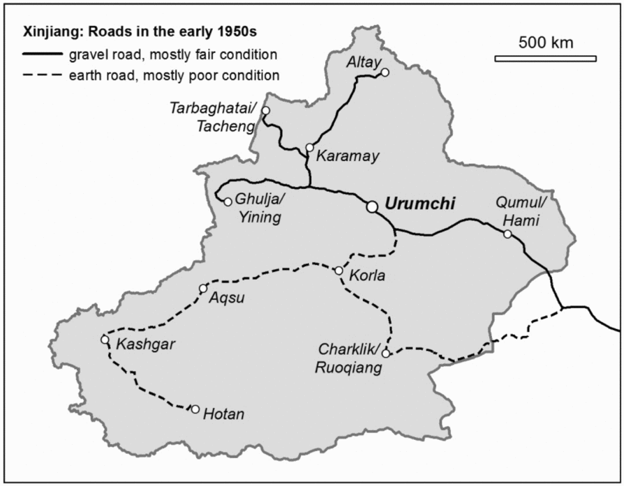
The situation changed after 1949. The importance of roads in facilitating military operations, consolidating territorial power, establishing Chinese sovereignty, and also in improving Xinjiang's economic performance through trade was recognized early on by the leaders of the Red Army who worked to consolidate Communist rule in the region.Footnote 28 In 1949 Xinjiang had 3,361 kilometres of usable dirt roads. This quickly grew to more than 6,000 kilometres by 1952 (see Figure 1) and, on the back of popular mobilization, to 14,000 kilometres by the end of 1957.Footnote 29 In the first decade of Communist rule, road construction was ideologically driven by the strategy of ‘building with local means, through mass mobilization and throughout the region’ (di qun pu). This style of spontaneous road construction produced largely unusable roads of extremely low quality.Footnote 30 In the early 1960s, during a period of political moderation, spontaneous construction was criticized and in 1964 ‘good roads’ (hao daolu) became one of the five components of the centrally coordinated plan to ‘establish a socialist countryside’ (shehuizhuyi nongcun jianshe). In 1965, as this period of moderation came to an end, Xinjiang officially had 22,675 kilometres of roads, including 368 kilometres of tarmac roads. The Cultural Revolution (1966–1976) halted most projects but even during this period about 5,000 kilometres of roads were tarmacked and some key bridges constructed.
Roads in the 1950s. Source: Xinjiang Weiwu’er Zizhiqu Jiaotong Shizhi Bianzuan Weiyuanhui (ed.). 1992. Xinjiang Gonglu Jiaotong Shi. Jindai Gonglu, Jindai Gonglu Yunshu [The history of Xinjiang's road transportation. Modern roads and modern road transport]. Beijing: Renmin Jiaotong Chubanshe, pp. 80–81.

The unitary national system of road classification introduced in 1979 revealed that out of more than 20,000 kilometres of roads in Xinjiang, about half were of substandard quality (dengwai gonglu). Another 8,000 kilometres were classified as either third- or fourth-class roads.Footnote 31 Transportation within the region was thus slow and inefficient. In order to address this situation, the central government invested in the construction of north–south and east–west trunk connections, and access roads to oil fields and mines. However, high underground water levels, high soil mineralization, and moving sands made construction of tarmac roads difficult even in the late 1980s, when a new transportation network was designed. The new network was to increase the political and economic importance of Urumchi as a regional power centre and counterbalance Uyghur power centres in Kashgar and Ghulja/Yili.Footnote 32
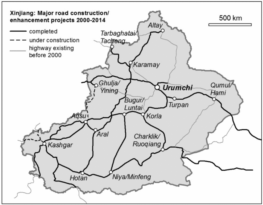
The year 2000, when the Great Campaign to Open up the West (Xibu Da Kaifa) was launched, is a significant threshold. Increased central funding brought about a boom in highway construction. New roads between southern and northern Xinjiang, across the mountains of Tengri Tagh/Tianshan, were constructed and older ones upgraded. In addition, road networks within southern Xinjiang, which is the focus of this article, were significantly extended and the existing roads improved (see Figure 2). The only eastward road connection between southern Xinjiang and eastern China was also enhanced.Footnote 33 As Justin RudelsonFootnote 34 points out, for many centuries southern Xinjiang has enjoyed better connections with Central Asia in the west than with China to the east.Footnote 35 The newly enhanced road network is designed to strengthen Xinjiang's eastward orientation and improve its territorial integration into the Chinese state. In the early 2010s construction work began on the strategically crucial road between southern Xinjiang and Tibet. This road crosses the contested territory of Aksai Qin (the subject of a border dispute with India) and runs alongside the Indian border to Lhasa, the capital of Tibet. Other roads alongside state borders which ‘embrace’ the Chinese state territory have also been built or upgraded.Footnote 36
Roads in 2014. Source: Xinbian Xinjiang Weiwu’er Zizhiqu Dituce [New edition of the atlas of Xinjiang Uyghur Autonomous Region]. 2010. Beijing: Zhongguo Ditu Chubanshe, Cehui Chubanshe, pp. 4–5; fieldwork material 2011–2012.
Until the late 1980s, or even early 1990s, attempts to rationalize and compartmentalize space in southern Xinjiang by means of road construction were significantly obstructed by natural obstacles (such as mountains and deserts), as well as a lack of technological capability. These hindered the construction of spatial ‘encompassment’,Footnote 37 especially in the far south, which maintained a certain degree of flexibility in terms of policy implementation. Even today this flexibility can still be seen, for instance in the adherence to an unofficial Xinjiang time in some public institutions in southern Xinjiang. It is a commonplace in northern Xinjiang that state institutions like schools, banks, government offices, and post offices use Beijing time, which is two hours ahead of the unofficial Xinjiang time. While this practice also prevails in most urban centres of southern Xinjiang, in the far south, adherence to Xinjiang time has not entirely disappeared from these institutions.Footnote 38 On multiple occasions research participants in southern Xinjiang emphasized also that in the past lengthy travel times hindered the implementation of central government policies and left space for their negotiation and adjustment. Moreover, because transportation was inconvenient, few Han immigrants settled in southern Xinjiang before 2000, which made the region a predominantly Uyghur-language space.
Today, with its north–south and east–west trunk lines, border roads, roads built and maintained by the Production and Construction Corps,Footnote 39 as well as access roads to extraction sites, in addition to railways and more weather-dependent airways, Xinjiang's tarmac roads form an increasingly dense network that binds the region together. However, though the analysis of the mappable expansion of road networks since 1949 may give the impression of a linear progression towards increased territorial cohesion, spatial rationalization, progressive expansion of state control, and ever-increasing circulation of people and goods, this process is uneven and has plenty of fissures, pockets, and side-channels.
Tarmac roads: perceptions, imageries, and anxieties
Among my research participants there existed a rather vague feeling that roads are a ‘good thing’.Footnote 40 However, the perceptions of what roads do and assessments of the way in which they expand, began to diverge when particular road projects were discussed. Informants in southern Xinjiang distinguished clearly between different categories of roads; the expressway was perceived as being something quite different from provincial highways and village roads. Through restricted access (fencing) and minimum speed regulations, the expressway excludes most local, rural traffic. As the majority of the rural population in southern Xinjiang—which is overwhelmingly Uyghur—cannot afford cars, petrol or the fees, they are largely excluded from being users of the expressway.Footnote 41 At the same time, this population bears the brunt of the negative effects of the expressway, since it bisects the earlier dirt roads and paths used by villagers to access their fields or to graze cattle. Thus, while the expressway connects urban centres and facilitates long-distance traffic, it interrupts and fragments previously existing spatial continuities in the countryside.Footnote 42 One can still occasionally spot individuals crossing the expressway where it passes through agricultural areas, illustrating how it has disturbed previously existing geographies of mobility. In numerous cases the new expressway has lengthened travel times instead of shortening them, such as where it bisected village-to-village paths and no underground passages were built to replace these. In northern Xinjiang, complaints by Kazakh pastoralists whose seasonal migration routes were bisected by the expressway abound. Moreover, because the expressway ‘steals’ the long-distance traffic from provincial highways, the previously existing roadside industry that catered for travellers and drivers has become cut off from its source of income as new sections of the expressway in southern Xinjiang are open to traffic. There are a couple of such ghost towns between Urumchi and Aqsu, where almost all businesses have shut down and people have moved away. In the restricted and uniform space of the expressway, only chain supermarkets—mainly selling goods from eastern China—are officially permitted to profit from the traffic flows. The sterilized modernity (xiandai) of these spaces stands in a contrast to the previous ‘chaotic’ (luan; that is, not centrally planned) private roadside restaurants and workshops. Nevertheless, today, some years after the opening of the Urumchi-Aqsu expressway section, a process of desterilization and reclaiming of place along the expressway has begun. For example, new, informal restaurants, hostels, and car workshops have grown up in the vicinity of the exits or behind some of the officially designated service stations, access to which is created by removing or shifting part of a roadside fence.
The stimulating effect of the expanding expressway network on travel between urban settlements is particularly evident within a 300–400 kilometre radius of Urumchi. Within this radius both Uyghur and Han report that distances have experientially ‘shrunk’ and travel for shopping and leisure among more wealthy segments of the population is becoming increasingly popular. The following conversation during a dinner with a Uyghur family from Turpan area illustrates this process:
Daughter: We buy many things in Urumchi now . . . We bought everything for our apartment in Urumchi; it is now only a two-hour drive by car.
Me: How long did it take before the expressway was constructed?
Father: Six to seven hours. The cars were bad and the road was bad. You had to stop for lunch on the way. You would not make the return journey in one day . . . But some people still prefer to take the old road because you don't have to pay for it.
Daughter: It is so convenient now. My father sometimes goes in the morning to Urumchi and comes back for lunch. Or people go for a day trip to have lunch or dinner with friends. Before this would have been impossible.
Father: Urumchi is closer to us, the feeling is that it's closer.Footnote 43
While the expressway does significantly improve the mobility of, primarily, the urban population in Xinjiang, as well as the connectivity between Xinjiang and eastern China, it is rural roads that matter most to the predominantly rural Uyghur. As John DonaldsonFootnote 44 demonstrates, based on his study in southwest China, the expansion of the rural road network has a direct effect on the improvement of rural household income by reducing the costs and time of travel, for instance, to the local markets or, as in southern Xinjiang, to the cotton fields. The expansion and improvement of these roads has started only very recently. Moreover, as my research material from the district of Aqsu demonstrates, while the expressway and provincial roads (important for long-distance traffic), roads along borders (crucial to border security), and also access roads to oil fields or mines are mostly fully funded by the central government, the improvement of village roads is, at least in some cases, left to county governments and local inhabitants themselves.Footnote 45
Obviously, ambiguity is inscribed onto roads, and thus perceptions of what they do vary greatly. Although the expressway seems to be the most polarizing, rural roads are not without controversies either, such as when roadside houses or mosques are demolished due to the widening of the road. Research participants also frequently linked road construction with the destruction of roadside flora which they saw as part of a larger process of environmental decline evident also in increasing salinity of soil and reduction in the water table. Trees, particularly those of the poplar family, traditionally lined roads in southern Xinjiang to protect traffic from the scorching sun and sand.Footnote 46 Though, for the most part, new trees are planted when roads are improved, they often fail to provide the same measure of protection because these new roads are much broader. Moreover, a number of Uyghur research participants observed that trees and other decorative plants planted along new roads are often imports from eastern China and are thus both climatically and culturally unsuitable for Xinjiang. In particular, the planting of coniferous trees—in Han culture the auspicious symbol of longevity—was criticized in arid southern Xinjiang, since these trees offer little shade and require more water than poplars and other autochthonous species. Changes in roadside flora were one of the major negative effects associated with road construction. Nevertheless, despite the many controversies that surround road-building and the spatial changes they bring about, new tarmac roads linking villages to county towns, and to other villages, usually quickly become part of local production and social life. Grain husking, the drying of fruits and vegetables, and the sale of agricultural produce all occur along new roads. In the evenings when the temperature drops, roads are also popular spaces of social interaction.
While my research participants pointed out the convenience and the suggestion of modernity that new roads bring about, they were wary of the other effects of road-building and increased circulation. The statement of Ötkür, a Uyghur from Hotan, illustrates a concern that is widespread in southern Xinjiang:
Southern Xinjiang's road network is going to be directly linked to inner China, not via Urumchi as it is now. This will open the way for Han people from Shanxi, Henan, and Sichuan to come to southern Xinjiang. You know, at the moment Han people don't want to come. They have to go to Urumchi first and then continue on to Kashgar or Hotan. It is a very long way. But when the fast line to Xi’an opens, they will come. When transportation is bad, Han migrants . . . don't want to come. When transportation is convenient, they want to come. And they come they will.Footnote 47
The growing connectivity with the east and the increasing accessibility of southern Xinjiang is regarded with anxiety by Ötkür and many other Uyghur. For the Han living in Xinjiang, the expansion of the road network is, in this respect, much less controversial. Most of my Han research participants discussed rather how new roads, coupled with new air and rail connections, facilitate their family visits and travel to their home towns and villages (jiaxiang, laojia) in eastern China. Dozens of Han interviewees reported that they have returned home for visits for the first time in decades following the improvements in transportation in the last few years. Government officials, both Han and Uyghur, emphasized that the mobility of officials has increased greatly with the expansion of the tarmac road network (and also airways). Trips to Urumchi or even inner China for training, regarded as a nuisance in the past, are today thought of as a welcome diversion and a pleasant feature of government jobs, even if some Uyghur officials simultaneously share the fears of other Uyghur around the increased accessibility of Xinjiang.
The mappable expansion of the tarmac road network has obviously had different effects on different social groups. For example, for many Uyghur women in southern Xinjiang who often travel locally on village-to-village or village-to-county town roads to fulfil family obligations, it is only the recent improvement of these roads that has begun to change their geographies of mobility and to affect their perception of distance. This selective ‘shrinking’ of distance, or ‘time-space compression’,Footnote 48 creates new social exclusions.Footnote 49 Structural limitations—poverty, gender, or the location of household registration—continue to restrict access to some categories of roads for some people. Furthermore, minzu identities make a difference in how this selective time-space compression is perceived, and with what kind of ambiguities and anxieties it is associated. The discussion of roads as lived space which follows further expands our understanding of what roads do by demonstrating their ambiguous role in the political geography of the state.
Lived space and the theatricality of the state effect
Aware of the ambiguity inherent in roads and the varied usages to which roads may be put, the Chinese state strives to increase its visibility on roads through road-related propaganda, but also through more tangible means such as roadside checkpoints. Hundreds, if not thousands, of roadside checkpoints exist in Xinjiang on county borders, at access roads to cities and towns, on border roads, expressways, provincial roads, and village roads. At times of local unrest, spontaneous militia checkpoints are established to block the circulation of specific people, goods, and information. The fact that local people adjust their spatial practices to the existence of permanent checkpoints demonstrates that these have become an integral part of mundane practices of mobility. At the same time, this adjustment is not simply about surrendering to the disciplinary power of roads and checkpoints. On the contrary, this adjustment creates new spaces for negotiation. I discuss this process briefly below through the example of two encounters with roadside checkpoints.
Checkpoints in Xinjiang differ in their visual appearance. Sometimes a checkpoint is a rope spread across the road between two chairs on which police officers or militia sit and control the traffic. At other places, checkpoints are firmly inscribed in place. They are marked by barriers and roadside shelters, or small buildings, with a couple of tables where policemen sit and check documents. At the many checkpoints I passed through, the overwhelming majority of the staff was male and Han. Most of them were friendly, helpful, and professional. Most of the checks are done quickly: a scan of a document, a glance at the face, a routine check of the boot of the car, and the car or bus is able to move on. Below I refer to two longer encounters that occurred on roads that had been recently tarmacked. When discussing encounters with authorities in detail, such as those below, I have decided to refer to my own experiences and not to those of my research participants. Although I find it uncomfortable to place myself at the centre of the narrative, it is unavoidable, since discussing the experiences of research participants could potentially have unpleasant consequences both for them and checkpoint officers.
The two accounts below are meant to highlight three elements central to my analysis. First, I show how the state marks and establishes its presence in Xinjiang through the institution of roads and roadside checkpoints. I then examine the theatricality of the act in which state officers and people passing through the checkpoints perform their recognition of the existing power relations. Finally, I demonstrate how the travellers establish a critical margin within these power relations, where renegotiation of agency becomes temporarily possible.
Case study 1
With my two foreign friends I am sitting in a private car driven by a male Uyghur driver. His wife accompanies us on this journey in order to keep her husband awake and help him when necessary during the exhausting ten-hour drive through the mountains. We are approaching a village located in a famous tourist area where we intend to stay overnight. Ten kilometres before the village, we come across a roadside checkpoint. It is 6 pm. Our car is stopped at the checkpoint and the following conversation occurs:
Traffic Officer (TO): Where are you going?
Me: To [the village], we heard about its beautiful landscape and want to see it.
TO: But foreigners are not admitted to this area without a permit. Do you have one?
Me: A permit? I inquired at the Police Office in Yili a month ago and was told I didn't need a permit.
TO: Your Chinese is very good. I’m very sorry but I can't let you pass without a permit.
Me: Thank you, I’ve been learning Chinese for a long time . . . Please, we’ve been ten hours on the way and we are really tired. We’ll just stay overnight here and tomorrow we’ll move on to Yili. This should be no problem.
TO: It's not possible. Can I see your passports?
Me: Of course. But honestly, is this a new regulation? It's really not our fault . . . Had we known, we would have got hold of the permit. It is usually not expensive. But now we have come all this way, we are really tired and there is no bus that can take us to Yili this evening.
TO: I really can't let you pass through, that's the regulation (guiding). [The officer goes back to the checkpoint and reappears after five minutes. He gives us back the passports.] Okay, we can do it like this: I’ll let you pass but you have to promise that you won't stay here overnight but will move on to Yili directly where you will apply for the permit [Yili is 280 kilometres away]. Then you can come back and stay.
Me: Hmm, okay, we could do that. Maybe we’ll move on tomorrow if there is no bus tonight.
TO: No, you can't stay here overnight.
Uyghur driver: We’ll take them to Yili tonight, no problem. We’re friends.
Me: Okay, sure, we’ll do that. Thank you for your help, officer.
TO: No problem. Have a good journey!
After arriving in the village, without a word, our Uyghur driver takes us directly to the first hotel we spot from the road. There the Uyghur couple helps us negotiate room prices and says goodbye; they go to stay overnight at their relatives. We stay in the village for two days before moving on to Urumchi by overnight bus.
Case study 2
My husband and I intend to go hiking in Tengri Tagh/Tianshan, in an area locally known for its hot springs and located close to the Kyrgyz border. Our bus is passing through a number of checkpoints on the way. At the last checkpoint before the bus reaches its destination, the police officer who gets on the bus to check the identity documents tells us to register at the police station at the bus destination before moving on to the settlement in the mountains. Habitually inclined to avoid the police unless absolutely necessary, we do not go to register. Instead we rent a local taxi and try to reach the settlement directly via a mountain road. Our car is stopped at yet another checkpoint on the mountain road and permits from the police station are requested. Our attempts at negotiation are unsuccessful and we have no choice but to go to the police station to get the permits. Our Kazakh taxi driver takes us there. I enter the police station at about 6 pm.
Me: Hello, I’d like to go to the hot springs in the mountains. I hear I need a permit to do that.
Station chief (SC): No, foreigners can't go there at all. It's a border zone. It is not allowed.
Me: But I booked a hut up there. I called the manager of the hot springs and he booked a hut for me. Why didn't he inform me? What shall I do here now?
SC: The owner may not know the regulations (guiding), but I can't let you go. [In the meantime, four police officers gather around to listen.]
Me: Please, issue me a permit and let me go. We’ve been more than ten hours on the bus and there is still a long way to the hot springs.
SC: I told you, foreigners cannot enter the border zone. Besides, I can't let you in because you don't have a permit from the county town. You need a permit from the county town first. When you have it, you can come back here and I might issue one as well.
Me: Are you telling me that I have to go back 70 kilometres to the county town to get a permit? How will I get there? There is no bus going there today.
SC: Ask your taxi driver, you can pay him and he will take you there.
Me: I’ve spent some years in China and I know this game you are playing. You tell me I should go to the county town to get a permit and once they have issued me one, you will too. But I know that in the county town they will say that I have to go to the prefecture town first to get a permit there . . . Why does it have to be so complicated? I learn your language; I make an effort to understand your culture. But I always get told, ‘Here you need a permit, this is the regulation, this you can't do, there you can't go. . .’ [I start crying. The police officers are visibly embarrassed to have a weeping foreign woman sitting on the doorstep of the police station.]
Police officer: Don't cry. We know that these regulations (guiding) are annoying (mafan). What can we do? We have to act according to regulations. It is a border zone.
SC: Go back to the county town and get the permit. When you have it, I will issue you one as well. I promise I’ll wait for your return and won't close the station before you get back.
Me: In the county town the police station will be closed by the time I get there, it's late.
SC: No, I’ll call them now that they wait for you. [He goes to call.] Go now, you’ll be there in one hour and you’ll be back in two hours. You can also stay overnight there, I can suggest a nice hotel where my relatives work. The conditions are much better than in the mountain hut.
Me: I will probably have to do that. I can't see how I can be back here in two hours with a permit.
Taxi driver: Don't waste any more time; let's go, I’ll give you a discount!
In the county town the permit was issued within ten minutes. An officer was informed about everything and only warned us to be careful in the mountains. Within two hours we were back at the local police station where everybody besides the station chief had gone home. He merely waved the car through and wished us a good stay (limited to three days). Then he got on his motorbike and went home. The checkpoint on the mountain road where we were initially stopped was gone and the barrier was open. The taxi driver explained to us that next time we should take this road after 7 pm, so that we wouldn't have to pay the toll or provide any permits, since the officers at the checkpoint would have gone home for the night.
The performative reproduction of power relations inherent in the spatiality as conceived of by the state is likely to be part of many, if not most, such encounters. In the second case study, the adherence to regulations (guiding) by the officials and travellers in registering passports and identity numbers while the officials are on duty, knowing that these very same checkpoints will be empty and barriers raised after these officials have finished work, is performed by both sides with equal seriousness, even if they do so for different reasons.Footnote 50 As state institutions (checkpoints) and checkpoint officers play the role of authority, so the travellers perform their recognition of this authority while the officials are on duty. At the same time, individuals with local knowledge are aware of, and have the capacity to explore, the fissures that exist in state performance of spatial control. The knowledge of these fissures, even if rarely actively deployed, allows individuals to renegotiate their position vis-à-vis the disciplining authority and creates something similar to what Soja refers to as the critical space of resistance and possibility.Footnote 51 This space takes the mappable/perceived and the spatial representations into consideration, but is more than them. Local knowledge makes it possible for individuals to recognize the theatricality of the performance of state encompassment and, through this, generates a third critical dimension of people's lived experiences of the road.
In the first encounter mentioned above, the police officer could not have realistically believed that we would travel another 300 kilometres that night, but he had to act according to ‘regulations’. The car driver knew that the group would not make it to Yili but, in order to preserve the dignity of the officer and to keep up the appearance of adherence to regulations, he also participated in the performance of authority. At the same time, he was aware that the regulations would be negotiable as soon as we left the brightly lit space of authority at the checkpoint behind us. The local knowledge of the Uyghur driver created a critical space from where we were able to renegotiate the power relations. At the same time, the spectacle of power and obedience was re-enacted at the checkpoint in a way that was satisfactory to the agent of the state. For reasons that can only be guessed at—pity for tired foreign travellers, positive impression of language skills, or maybe the fact that most of the car passengers were female—the officer facilitated the occurrence of this critical space. In the second case study, the disciplinary power of the state which attempts to control access and circulation of people also turns out to be negotiable, again in this case with the help of state officials. For reasons that again can only be guessed at, the officers paradoxically helped us bend the regulations and, more or less of their own accord, arranged the permit that made it possible for us to enter the closed area. While I, a foreigner, tried to force my way through in spite of the regulations, those with local knowledge patiently waited for state institutions to come off duty.
Both case studies reveal that there exists a ‘superfluity of meaning’ in roads.Footnote 52 Though tarmac roads are built with certain intentions—for example, to spur ‘development’ or increase some forms of circulation—instead of a one-to-one translation of input into effect, the influence of the material on the social is instead ‘deflected’.Footnote 53 In the two case studies, the local knowledge of the Uyghur and Kazakh drivers enabled them to live the road in its experiential ambiguity. Though awareness of this ambiguity is rarely directly used in a ‘subversive’ way, as Soja would have it, the awareness of this ambiguity itself allows individuals to renegotiate the relationship with the disciplining power manifest in regulations (guiding), which individuals may choose not to obey in certain situations. For example, since licence plates can make a great difference at checkpoints—cars with Urumchi plates are frequently waved through, as are those cars with army, police, and government licence plates—some district, city or institutional plates are a sought-after commodity on the black market. Because occupants of cars with Kashgari or Hotani numbers are exposed to much greater harassment during roadside checks, even being denied access to some roads, Uyghur individuals from these districts may try to purchase cars through relatives living in other districts and have them registered there. Travelling at night to avoid most of the checkpoints is yet another strategy. People also drive on village roads instead of main roads, and travel in cars belonging to work unitsFootnote 54 whenever possible. During one of my journeys, the driver—a local Han government official—placed a self-made plastic sign in the front window of his car which announced that the car belonged to the expressway management office. This sign meant that we were waved through checkpoints and even allowed us admittance to a newly built section of the expressway still officially closed to traffic! Though one might associate such contesting of the disciplinary power with Uyghur and other non-Han minorities in Xinjiang, the Han are also participants in this ‘game’, even if ethnicity may affect motivations for participation.
Brief conclusion
Lefebvre’sFootnote 55 and Soja’sFootnote 56 proposal to discuss space as a complex assemblage of ‘the mappable’, imageries and representations, and the experiential complexity of ‘the lived’ helps us to grasp the multiplicity of spatial figurations in which roads are caught up in China's border regions. Road construction in these regions does change the organization of space, notions of distance, and facilitates the creation of specific forms of spatial boundedness that focus on administrative centres. Moreover, through tarmac roads and roadside checkpoints the disciplinary power of the state permeates and thus transforms mundane practices of mobility. It also introduces new forms of spatial partitioning and hierarchical spaces.Footnote 57 At the same time, however, the expanding tarmac road network and the network of roadside checkpoints are deceptively neat visualizations of the ways in which disciplinary power establishes itself in space and among people. Varied perceptions of roads show that road construction is a process with different associations for individuals, depending on their minzu, gender, and social class, and linked to different types of anxieties, inclusions, and exclusions. These obviously influence the efficacy of disciplinary power. Moreover, as evidenced in my two case studies, the localized knowledge of the setting in which this power operates reveals its situational theatricality, allowing individuals to explore the fissures in its performance.