Introduction
Agricultural aerial spraying plays a more and more important role in the development of precision agriculture, because of the significant advantages such as high efficiency, quick response to sudden plant diseases and good atomization (Zhang et al., Reference Zhang, Chen, Lan, Xu, Kan and Zhang2014). Manned agricultural aerial spraying is widely used in large areas of farmland (Zhou et al., Reference Zhou, Zang, Luo, Lan and Xue2013). There are some serious problems during the progress of manned agricultural aerial spraying, such as heavy workload in route planning, overlaps or omissions in spraying (Xue and Lan Reference Xue and Lan2013). These problems seriously reduce the efficiency of spraying and utilization rate of pesticides. To solve the problems of manned agricultural aerial spraying, this paper presents the design and development of a navigation system for manned agricultural aerial spraying (hereafter referred to as the navigation system) based on an industrial tablet PC. The navigation system provides three key functions: route planning, spraying navigation and real-time evaluation of spraying quality. The function of intelligent route planning can reduce the workload in manual route planning. The function of navigation and real-time evaluation of spraying quality can assist aviators in flying straight, thus the phenomena of overlaps or omissions in spraying can be reduced.
Existing agricultural aerial intelligent systems can also solve traditional agricultural aerial spraying problems. AgJunction Satloc G4 provides a series of route planning patterns (Anonymous, 2017b). AG-NAV Guia Platinum provides many ways to generate new areas (Anonymous, 2017a). TracMap Flight 3 provides an online data center for exchanging flight information (Anonymous, 2017c).These systems are advanced and powerful, but they often have disadvantages of high complexity, weak localization and high cost in China. This paper focuses on the main functions which are requisite for an agricultural aerial navigation system, providing a minimum viable extensible customizable system in consider of Chinese conditions.
System design and development
The main hardware equipment of the navigation system is an industrial tablet PC. The usability of the navigation system has nothing to do with the brand and model of the industrial tablet PC. The main requirement is a steady software runtime environment that is able to communicate with a Global Navigation Satellite System (GNSS) receiver (Zhao and Cao Reference Zhao and Cao2008). To meet the demand of Chinese manned agricultural aerial spraying, focusing on the core issue of aerial direction, this paper presents the main design and development progress of the navigation system, including process flows, technical points and solutions for technical obstacles.
Process flows
There are many process flows in the navigation system. The process flows presented here are the core parts related to key functions. To meet different working conditions, the navigation system provides two main process flows according to the requirement of planning: planning in advance and planning when flying.
The process flow of planning in advance can be applied to farmlands with complex boundaries or with a large amount of small fields. The accuracy of boundaries is the major concern of this pre-flight planning process flow (Figure 1).
Process flow chart of planning in advance.

In the stage of route planning, aviators can get lines of the spraying route (hereafter referred to as spraying lines) by entering spraying regions and spraying parameters (swath, heading direction, etc.). The source of spraying regions can be defined with the known coordinates of the spraying region boundaries or drawings on satellite images. No-spray regions and barriers for warning can be marked in the same way. In the stage of navigation, GNSS signal plays a leading role. Every GNSS position is used to accomplish spatial computations with spraying regions, no-spraying regions, barriers and spraying lines.
The process flow of planning when flying can be applied to farmlands with normal boundaries or with large area in a whole block. The convenience of operation is the major concern of this process flow. The process flow chart of planning when flying is as shown in Figure 2.
Process flow chart of planning when flying.

There is no independent stage of route planning in the process flow of planning when flying. Aviators can plan a route by defining a baseline during flying whenever needed. The navigation system can intelligently generate spraying lines according to baselines and working parameters. As the spraying lines are generated from inside out, there can be as many as the navigation system requires.
Technical points
As a complex information system used in high-risk activities (Xue et al., Reference Xue, Liang and Fu2008), it is very important for the navigation system to be stable and reliable. There are many ways to improve stability and reliability of complex information system, while object-oriented programming and event-driven programming are the most efficient.
Object-oriented programming makes it possible to partition a whole complex system into smaller classes with independent properties and methods (Wang et al., Reference Wang, Wu, Li and Yang2002), and the stability and reliability of a class is much easier to guarantee. To achieve a better object-oriented architecture, every class must have only one single responsibility. A feasible three-tier architecture for the navigation system is shown in Figure 3. Four main manager classes in the data access layer provide the ability to read and write basic data, such as GNSS data, base map data, log data etc… The classes in the business logic layer are responsible for the transformation between basic data models and business logic models, providing most of the core functions, such as route-planning, navigation and so on. The presentation layer is the interface to users, providing control classes with input and interaction capabilities.
Component of the navigation system.

Event-driven programming makes it possible to decouple event listeners and event handlers (Liu and Wu Reference Liu and Wu2008), so that event listeners won’t block the system until corresponding events happen. It is helpful to reduce the chance of blocking calls in the whole system. There are many events in the navigation system, and the key events related to navigation are shown in Figure 4. A new GNSS data received event causes a series of more complex events, such as a position changed event, a highlight spraying line changed event etc… By extracting interactions between classes as events, the navigation system achieves a flexible architecture with the specialty of high cohesion and low coupling.
Key event-driven model of the navigation system.

Solutions for technical obstacles
As an information system for navigation, there are two main technical obstacles in the navigation system: the display of maps and the transformation from GNSS signal to visual navigation information.
The most effective way to display a map is using a Geographic Information System (GIS). As there are no complex statistics and analyses in the navigation system, a traditional GIS is too heavy and not required (Li Reference Li1997). By customizing open source GIS software libraries, the navigation system provides a map engine for agricultural aerial spraying that is much thinner than an integral traditional GIS. This map engine makes it possible to display and operate hierarchical key elements, such as flight tracks, spraying regions and barriers. This map engine provides methods to add, delete, update and search an instance using a globally unique identifier. Every layer on the map has a fixed level. For example, the layer of flight tracks is always on the top, while the layer of base map images is always on the bottom. The hierarchical structure of the navigation system’s main map layers is shown in Figure 5. The meaning of position relationship in Figure 5 is not the same as in Figure 2. In Figure 2 lower objects provide support for higher ones, while in Figure 5 higher layers will be displayed on the top of lower ones.
Map layers of the navigation system.

A GNSS receiver provides location data to the navigation system. Most GNSS receivers can provide location data according to the protocol of NMEA-0813 (Cao and Gao Reference Cao and Gao2006). NMEA-0813 organize data into different themes, such as Global Positioning System Fix Data (GGA), Recommended Minimum Specific GPS/TRANSIT Data (RMC), Track Made Good and Ground Speed (VTG) etc… By parsing NMEA-0813 sentences, location data can be transformed into useful location information for the navigation system, such as longitude, latitude, altitude and velocity. The indigenously developed navigation model can transform location information into visual navigation information, which can guide the aviator effectively. To put it simply, the navigation system shows an aviator what situation they are in and what they should do next. The user interface of the navigation system when the aircraft is flying is as shown in Figure 6.
User interface of the navigation system.

The aircraft in Figure 6 has just flown out of a spraying region. There is a guide line on the map between the aircraft and the intersection of the focus spraying line and the spraying region’s boundary. The navigation information shows that the aircraft is 33 meters away from the 13th swath line from the original baseline (A-B line). The navigation system can be placed in front of the aviator as shown in Figure 7.
Application of the navigation system on a helicopter.

Application test and evaluation
During the years from 2013 to 2016, this system was applied to mainstream agricultural manned aircraft, such as Bell 407, R66 and Air Tractor 802F. The navigation system recorded all the flight tracks and provide a review function to display flight histories. An example display of the flight history review is as shown in Figure 8.
A spraying project review of the navigation system.

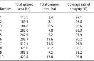
The flight history review contains a total sprayed area. By overlaying satellite image layer, the gaps between sprayed regions can be judged to be an omission region or not. From the statistics of the omission region areas, a total omission area can be figured out. This paper choose 10 typical spraying flights using the navigation system to calculate total sprayed area, total omission area and coverage rate of spraying. The result is shown in Table 1.
Statistics of total sprayed area, total omission area and coverage rate of spraying of 10 typical spraying flights using the navigation system

In Table 1, the minimum coverage rate of spraying is as high as 96%. In all existing valid spraying flights using the navigation system, the average coverage rate of spraying is also greater than 96%.
The coverage rate of spraying relates to lots of factors, such as, the wind speed when flying, the topography, the distribution of barriers, the ability of aviators and so on. The better the spraying condition is, the higher the coverage rate of spraying is. The coverage area on ground is not always the same as the one at the altitude of the aircraft. The deposit distribution pattern is a complex index which needs to be measured by special instruments (Zhang et al., Reference Zhang, Lan, Chen, Wang and Liang2014). To focus on the core function of navigation, this paper ignores the influence of deposit distribution pattern.
Conclusions
It is feasible to design and develop a navigation system for manned agricultural aerial spraying based on a common industrial tablet PC. The intelligent route planning function of the navigation system can reduce the workload in manual route planning, and the average coverage rate of spraying in the spraying flights using the navigation system is greater than 96%, and as a result, the navigation system in this paper can meet the demand of manned agricultural aerial spraying in route planning and navigation.
Acknowledgements
This work is supported in part by National Natural Science Foundation of China (31601228), Beijing Natural Science Foundation (6164032) and State’s Key Project of Research and Development Plan (2016YFD0200700). Colleagues at the Beijing Research Center of Intelligent Equipment for Agriculture and National Research Center of Intelligent Equipment for Agriculture helped the authors a lot when designing and developing the navigation system.