

Introduction
Until the late nineteenth century the world described in this paper had been identified on the colonial map as ‘Wild Tribe’, akin to an irregular inverted triangular shape, located between latitudes 21° and 24° north and longitudes 92° and 94° east, and encircled on all sides by established valley states. To the east and south were the Kale-Kabaw valley and Arrakan states of Burma, to the west was the British Indian district of the Chittagong Hill Tracts, in the northwest was the state of Tipperah (Tripura), and to the north lay the British district of Cachar and the state of Manipur. Today, this region is part of the Mizoram state of India, the Chin Hills state of Myanmar, and some contiguous territories around them. Just as it received the uniform civilizational name of ‘Wild’, it is also treated here as a separate sub-cultural zone within the larger region known as ‘Zomia’.Footnote 1 This sub-cultural zone was, and still is, inhabited by the ‘Kuki-Chin’ people of the Tibeto-Burman language family (excluding Meitei/Manipuri).Footnote 2 It was from here that a series of sanguinary raids upon British territory were committed before the zone was annexed into the Empire. This paper looks at the period prior to the annexation in 1892–1893 beginning with the early decades of the nineteenth century. This period is crucial to the history of this ‘Wild’ country, in that some Kuki chiefs obtained western-made firearms which led to the emergence of a new political formation. Their territorial expansion resulted in the subjugation, displacement and migration of its people in a series of chain reactions that ultimately pushed many of them out into Manipur, Tripura, and the British districts of Bengal and Assam.Footnote 3
This paper attempts to understand the Kuki raid in relation to colonial spatial ideology and its hill-valley binary. Although forms of tribal and peasant resistance differ from one context to another, it is an accepted view now that they resisted established authority when their very existence, such as their historical rights over land and resources, was under threat, and/or against different layers or forms of exploitation and control which they regarded as intolerable.Footnote 4 This paper makes the point that the Kukis raided British territory when they perceived that the colonial boundary had gradually encroached upon their traditional ‘hunting ground’ and threatened their very existence as an independent state-evading population in the hills.
The raid in this context is understood to be resistance against an established state by an independent ‘not-a-state-subject’ people, in defence of their autonomy in the hills. The curtailment of their ‘hunting ground’ that is understood to be the purveyor of their autonomy was, therefore, an existential question to the Kukis, and raiding in this context needs to be studied separately from other forms of raid which were commonly seen in the frontier. Contrary to the colonial notion of tribal raid as representative of the ‘unruly’ people, it will be seen that it was well organized, premeditated, and based on their own understanding of their world order. Although it appeared to be a non-state practice by employing a descend-and-disappear method, it recalls familiar state practices in the region a century or so before.
The raid is studied here in the context of a conflicting notion of space and territoriality between the colonial state and the Kuki tribes. The emerging notion of space under colonialism which was seen as being both quantifiable and measurable in terms of resources to be controlled and improved, drastically superseded vernacular notions of space and territoriality. It will be noticed that the colonial state's definitive geography and the extension of a neatly defined boundary line in the frontier, in the hill-valley continuum, and amidst the indigenous hill polities whose notion of space, territoriality, and sovereignty were markedly different from those of the colonial state, resulted in a conflict of authority over space. Harping on the ‘core’ civilizational discourse, this colonial spatial ideology also resulted in the making of hill-valley binary, which had played a vital role in animating tension in the frontier. Such a dichotomy, as reflected in the form of socially and spatially engineered familiar terms such as: ‘civilized’ versus ‘primitive’/‘savage’; ‘organized’ versus ‘unruly’; ‘settled’ versus ‘barbarian’; ‘agrarian field’ versus ‘forest’; ‘expedition’ versus the ‘raid’; and so on, upset the existing relationship and instilled a measurable amount of tension in the frontier which culminated in ‘raids’ from both sides.
The precolonial period: hills as a hideout, as an ally, or even a lord
The hill-valley relationship in the precolonial Northeast frontier of India may be understood as something symbiotic rather than confrontational. Whilst the hillmen had prevented appropriations of their space by the valley states at all cost, they appropriated valley resources whenever they could. The existence of the hill-based statelets, such as Tipperah, Jaintia, and Kachari, with their own particular areas of revenue extraction extending throughout the valley, are cases in point.Footnote 5 The hillmen often willingly helped the lowland political actors in their struggle for power. Some of the valley court potentates and other fugitives often took refuge in the hills in times of adversity. The landlords bordering them usually paid ‘a species of black-mail to procure exemption from their attacks’; and there was a free-flow of goods up and down the hills for certain basic items.Footnote 6 The Manipuri kings, for example often took refuge in the hills from successive Burmese invasions or occupations of Manipur.Footnote 7 This is also true of some local potentates in other states.
Some soldiers of the Burmese army which occupied Telyne and its neighbourhood in 1824 never returned to Ava, but instead settled amongst the Kukis in the hills of south Cachar.Footnote 8 It is no wonder that the hills were also a refuge to many fugitives in British India. The Kale Sawbwa ‘pretender’, who was given shelter by the Falam Chins during the British occupation of Upper Burma, and the 1857 ‘rebels’, who took shelter in the LushaiFootnote 9 Hills, are a few cases in point.Footnote 10 Indeed, raids in Cachar during 1868–1869 were ascribed to the tactic employed by a Manipuri prince, Kanhai Singh, to divert the attention of the British authorities from his vigorous attempts to enter Manipur and seize the throne. He was said to have considerable influence amongst the Kukis from whom he acquired his mobile forces.Footnote 11
With these possibilities in hand at the margins of the state, the hills and its inhabitants had always been seen by valley potentates as important partners during times of adversity, which were frequent, and were always expected in the unquiet valley space. As these partnerships, or sources of power, provided much required assistance in times of uncertainty, maintaining a good relationship with the hillmen continued to be a priority for most valley states, as in the case of Manipur's annual Haochongba festival, in which
men of the various tribes came down to Imphal to perform feats of strength and agility [and] the day was concluded with a feast, at which they are regaled with the flesh of cows, buffaloes, dogs, cats, & c., which have died in the valley. . .dried and preserved on purpose for this feast, and being supplied with plenty of spirits.Footnote 12
The fact that the Tipperah kingdom was long associated with the hill Kukis as soldiers, courtiers, and allies is attested by its royal chronicle.Footnote 13 The Falams of the Chin Hills even had defensive and offensive alliances with the Sawbwas of Kale.Footnote 14 Many of the frontier zamindars also paid tribute to the hill chiefs for cultivating the land over which the zamindars had claimed authority. Such claims were usually tolerated by the valley courts as a means to maintain peace in the frontier. Thus, the Kuki chiefs living in the hills bordering Cachar and Sylhet were ‘in the habit of receiving yearly presents from the frontier zamindars’ or woodcutters ‘as the price of safety’, and ‘failure to acknowledge their claims invariably led to bloodshed’.Footnote 15 With the consent of the Burmese court, the Yokwas in the Chin Hills annually received tribute from the bordering Burmese plainsmen in the form of ‘Yaw blanket and a viss [3.6 lb] of salt from all the villages on the border on the condition that raiding ceased’.Footnote 16 In this way many of the plains villages were literally the ‘adopted villages’ of hill chiefs who, as tribute receivers, protected them from being attacked—as in the case of Falam chiefs who protected Burmese villages adjoining their territory.Footnote 17 Thus, there was always an overlapping sovereignty in the border areas, over which both the valley states and the hill polities claimed authority.
Although the hillmen were adamant in refusing to allow outsiders into their territory or villages, traders from the plains continued to go up into the hills. Likewise, the hillmen freely came down to the plains to barter their hill produce. Indeed, border plainsmen continued to supply the hill people with items needed in the hills like common salt, metals, and utensils, either in the form of tribute or in exchange for hill products. In this context, the movement of goods and people from the plains to the hills and vice-versa was a continuous process and this economic interdependency remained the rule in their relationship. Even if conflict might often have occurred, it usually gave way to compromise, because the hillmen were strongly protected by a strip of forest which was an impassable barrier, out of the reach of the valley states, and from which they could easily come down to avenge any insult. Therefore the hillmen provided sources of support, power and a place for hideouts, and even as lords over many plainsmen.
Colonial representation of the raid
In the colonial imagination, however, the ‘raid’ was understood to be an expression of the ‘lawless and predatory habits’ of the ‘savage hill tribes’, whose ‘natural love of plunder’ took pride in it as a ‘cold weather amusement’ to procure human heads or captives for sacrificial purposes.Footnote 18 Harping from this positional civilizational discourse, Captain R. Boileau Pemberton, in his famous report on The Eastern Frontier of India (1835), remarked that the Kukis, inhabiting the inaccessible, broad, hilly tract between Tipperah and Chindwin river, lived in a state of splendid isolation, with ‘implacable enmity’ from one village to another as to their ‘low-land neighbours’, their ‘state of society’ being fluid and lacking ‘unity of feeling’, and were ‘wholly incompatible with any mental improvement, or any advance in the arts’. The Kukis, he added, pursued ‘the same unvarying course’ of (shifting) cultivation, and after harvest they ‘either resign themselves to the unrestrained indulgence of feasting and dancing, or in planning [raiding] expeditions’, that ‘frequently made incursions into the border villages, along the line of frontier’. The motive of such bloody raids, Pemberton imagined, was not so much the ‘plunder of property’ as the ‘acquisition of heads’, that is ‘essential to the due performance of the funeral rites of their village chieftains’.Footnote 19 Thus, raiding was seen as a post-harvest amusement and the hills were the source of danger from ‘unruly’ people.
In this scenario, the ‘core’ civilizational discourse current in the Western world had played a vital role. Although arriving quite late in the area, L. A. Waddel could still wonder in the 1900s: ‘here, almost at our very doors is a unique mine of unexplored material for yielding that very kind of unrecorded information which Professor TYLOR [sic] and others have shown the urgent necessity for fixing without delay in order to solve many important problems respecting the origins of our civilization’. This ‘fast vanishing knowledge’, he insisted, should be ‘immediately’ recorded before it is ‘irretrievably lost to the world forever’.Footnote 20 The hillmen became the rare ‘specimens’ of ‘the races of the Old World’, reduced to being the ‘subject of scientific study’.Footnote 21 Of several other qualifications, raiding became an essential part of such representation ascribed to the ‘old world’. Hence, raiding represents the ‘old world’, and ‘primitive’ practices.
In this construction, the hills are necessarily where the plainsmen came from, the hillmen ‘our’ ancestors, and the hill society the ‘origins of our civilization’. Thus, the hill people are ‘primitive races’, the ‘children of nature’, and the ‘rare vestiges of prehistoric society’ that ‘still survive’ to provide the missing link ‘respecting the origins of our civilization’.Footnote 22 In ‘our’, i.e. the Western, imagination, the tribes were always the ‘origin’, never the ‘end’. They were always ‘vestiges’ of pre-history, pre-civilization or pre-state, but could never be the post anything; they are not a form of civilization but a product of no-civilization. Their ‘inaccessible’ hills were but ‘the habitat of savage tribes’ whose ‘barbarians forsooth’ were ‘very little better indeed than the apes among whom they reside’.Footnote 23 So the ‘barbarians’ were to be kept at arms length: the (in)famous ‘Inner Line Regulation’ of 1873 ‘strictly prohibited’ all governed plainsmen to venture out into the hills without permission.Footnote 24 Only ‘wild hospitality’ and ‘intimacy’ with them could, and would, tame the ‘barbarians’.Footnote 25
The hospitality in question was not so much the white magic of kindness, but equally barbaric regular expeditions into the hills to tame the barbarians.Footnote 26 The hills were later annexed into the Empire, once again under the figleaf of a ‘civilizing mission’, not so much to anything as to ‘civilize’ and ‘humanize’ the ‘savages’ as to prevent them from raiding the state space. Damaging as it was, this linear and sequential view of civilization still dominates the understanding of the Northeast hill ‘tribes’, as if it is not a ‘free subject of thought and action’. But the hills in reality seem to show exactly the reverse of this linear view of civilization.
Kukis as a state-evading people
The Kukis, as a state-evading population, have been discussed elsewhere and need not be elaborated here. However, for the sake of analysis, a brief outline is given. James C. Scott persuasively argues why highlanders, instead of being ‘left behind’ by the valley civilization, were those who fled oppressive state-building projects in the plain. They are, instead of being prehistoric ‘primitive’ people, the ‘post’ of, or the product of, valley base civilization, and not the other way round. Their culture and agriculture, subsistence routines, pliable social and ethnic identities, bewildering physical dispersal, dependence on oral traditions and on the heterodox sects, are their ‘Art of Not Being Governed’, which is politically ‘positioned’ to prevent appropriations by valley states and ‘state-like’ power concentrations in the hills.Footnote 27 Thus, it was their ‘culture and agriculture of escape’. The hillmen generally fled the state, to the inaccessible fastness of the hills, Scott notes, to avoid state slavery, raids, conscription, taxation, corvee labour, epidemics, and warfare.Footnote 28 This sufficiently explains the long history of Kuki migration to their present hills. That they were once valley settlers, living in a ‘walled city’, and possibly under their own rulers or otherwise, is corroborated by their deep-seated oral traditions. Oral history and legend have it that the Kukis migrated initially from in or around China to the Chindwin valley of upper Burma, during the early Common Era or before the eighth century, and between the ninth and fourteenth centuries they settled in their present hills.Footnote 29 Legend has it that they once had their own ‘kingdom’ in the Chindwin valley, from where they fled the advancing Shan and Burmese state-building projects.Footnote 30
Major G. E. Fryer noted one interesting, and popular ballad amongst the Khyengs (Asho—one of the Kuki tribes) of the Sandoway district of Arakan in which they have the tradition, that they came down many years ago from the source of the Chindwin river and settled down in the Chindwin valley and lived in their charming ‘brick walled city’, until they came over to their present hills.Footnote 31 Most Kuki tribes have similar traditions. Chindwin valley is known to them variously as Kangmaiphai, Lajangphai, or Neelphai, (phai or plain), and the Chindwin river as Tuihat, Chindung, Gundung, Run, or Tuikang. The Lushais claimed that the great ‘Khumbat [Khampat] Chief’, who lived within a fort settlement, was actually their ancestor. Situated between the Pong and Manipur kingdoms, Khampat ‘kingdom’ was destroyed by the joint forces of the other two states.Footnote 32 If their account of their migration from the upper source of the Chindwin river is accepted, then it follows that they were one of the advance guards of ‘China's [Long] March toward[s] the Tropics’.Footnote 33 Legend has it that the Kukis escaped to their present hills in the face of great fire, great darkness, great flood, great famine, and great epidemic, caused by both natural and human forces which made living in the plains impossible.Footnote 34
If their ‘brick walled city’ points to the ‘level plains’ settlement, then it makes sense to assume that their mythical place of origin, the Sinlung, Chhinlung or Khul, from where they escaped to the ‘upper world’, was the ‘walled city’ of the plain.Footnote 35 One ballad is instructive: ‘Out of city Sinlung; I jumped out like a siel (mithun); Innumerable were the encounters; With the children of men’.Footnote 36 Literally, sin means an enclosure or rampart, and lung means rock, which refers to a rock enclosure, a synonym of a ‘walled city’. It was also known by different names such as Noikhomang or Noichinboulpi, both having the same connotation.Footnote 37
In another ballad ‘Sinlung’ is referred to as the ‘homeland of our ancestors’ (Kanu Ram Kapa Ram Ngai).Footnote 38 Where the ‘walled city’ Sinlung or Noikhomang actually was, whether in Chindwin valley or elsewhere in China, is beyond the range of empirical research. Yet, these ballads all suggest that the Kukis were once plains-dwellers. The raised platform of their houses, the pre-eminent position given to bell-metal gongs in their cultural practices, and the legend of their ‘lost scripts’, to mention a few cases, point to the same conclusion. Again, according to another handed-down oral legend, they escaped from Sinlung due to the cruelty of the king.Footnote 39 The phrase ‘Remember Sinlung!’ is still commonly used amongst the Kukis to warn any chief, or someone who has become unduly tyrannical, that should he become too oppressive, just as they once deserted the oppressive ruler of Sinlung, such a chief would soon find himself to be a king without any subjects. Interestingly, they still maintain a millenarian concept of going back to the valley to rebuild their ruined ‘kingdom’.Footnote 40
This is how the Kukis chose to ‘re-ethnicize’ themselves in the hills by a sort of ‘civilizational backsliding’ which was but a ‘political choice’ to evade oppression; a strategically chosen amorphous position at the margins of the state. The guiding principle behind their migration into the hills was, therefore, the preservation of their autonomy and what I call the ‘hill matrix’ because it underpins the essence of the world in which they lived in the hills. Re-ethnicization, therefore, involved the invention of what James Scott called the ‘culture and agriculture of escape’.Footnote 41 These included physical dispersion on rugged terrain, separated by distance, shifting fairly frequently, with no central core, having pliable ethnic identities, dependence on oral traditions, ultimately sustained by the subsistence economy that enhanced mobility. These are the peculiar characteristics of the refuge zones which prevented their appropriation by organized state societies and the state-like concentrations of power in the hills and essentially represented the expression of the hill matrix. That the Kukis were indeed ‘administrative nuisances’ was aptly noted in 1929 by J. H. Hutton, Deputy Commissioner of the Naga Hills and Director of Ethnography, Assam:
When I first made the Thado's [Kukis] acquaintance and for years after, I regarded him merely as an administrative nuisance. His habit of splitting up his villages into scattered hamlets of two or three houses in the jungle, so that this year's village is never where you expected to find it, and his irritating way of making a fuss about the unpaid price of his defunct second cousin's great-grandfather's sister's bones are not calculated to endear him to a district officer. . .He is a bad cultivator, and much behind the surrounding tribes in agriculture, though as much ahead of them in such domestic arts as weaving or working in metal.Footnote 42
Such a culture (and agriculture) of escape was indeed a politically calculated choice not ‘to endear him[self] to a district officer’ and hence made the Kukis ‘administrative nuisances’. They were traditionally protected from him by another important constituent of the hill system, and were also part of the expression of the hill matrix commonly known as the ‘hunting ground’ which is discussed in the next section.
Agrarian field, forest, and the ‘hunting ground’
The notion that perhaps there was no conflict over village boundaries or territory amongst the tribes is misplaced in the context of the Northeast region of India. Wars were fought over disputed village boundaries, especially amongst the Kukis, as is recorded, for instance, by J. W. Edgar, Deputy Commissioner of Cachar, in his famous report on the Lushai Expedition 1871–1872. When Edgar first acquainted himself with the hill situation he remarked:
Among all the tribes on the frontier there is a very strong feeling about boundaries. Each village has its limits which are known and respected by the tribe around as long as they are at peace with it, and any attempt made, except in time of hostilities, by one clan to occupy lands belonging to another clan, would be condemned by everyone.Footnote 43
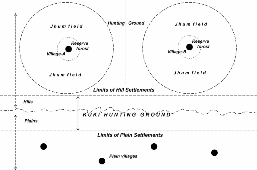
But when there was ‘a very strong feeling about boundaries’ amongst moving communities like the Kukis, it should be noted that these boundaries shifted as frequently as did their villages from one place to another. In this context, there could be no permanent boundary because a fixed village system was anathema to their political choice to be a moving community at the margins of the state. Yet a peculiar tradition of this moving community was the strict preservation of the names of the villages they had previously occupied, by a class of what Dalton has called a ‘hereditary priesthood’ or ‘conservators of traditions’, thempu or puithiem or passin (literally wiseman or priest).Footnote 44 In all the priestly chanting during a particular sacrifice, the names of earlier settlements were successively chanted until the present one had been established.Footnote 45 This is peculiar because Kukis were known for not having much attachment to their old places, and for being averse to occupying any abandoned settlement. There are no obvious clues to explain this peculiar tradition but it would certainly help them to locate their origins and hence their history. Bearing this in mind, the Kuki's notion of land and territoriality may be represented as containing features as illustrated in Figure 1.
Schematic representation of a Kuki village and its ‘hunting ground’

A typical traditional Kuki village was surrounded by its reserve forest called meilam (literally fire way) or ujok (preserved trees) beyond which was the cultivated zone and at the outer circle was their hunting ground. The meilam, as the name connotes, was mainly a buffer against turbulent wild fire. Besides, it was preserved for procuring wild fruits and vegetables, dead wood, and as a grazing ground for domesticated animals. It was literally the ‘garden’ of the village community. This meilam was followed by the agriculture field (lougam) where the annual shifting cultivation took place in seven to ten-year cycles, re-cultivating the first field when the trees had attained their full strength.Footnote 46 Thus, when they had reaped their needed food, the natural forest was then allowed to regenerate resulting in sustainable forest cover. But what is of particular interest in this analysis is the outer circle of their territory commonly known as the ‘hunting ground’.
Kukis have a tradition of preserving a densely forested strip of land beyond their cultivation zone, as shown in Figure 1. This deep-forested area was literally preserved for wild animals and birds to flourish and from which they procured their meat. In this context it was their hunting ground where the men of the village were engaged on a regular basis to hunt for wild game. Shakespear remarked that, ‘Large hunting parties make lengthy expeditions into the uninhabited parts in search of elephants and wild mithan’.Footnote 47 This ‘hunting ground’ could be shared between two adjoining villages in times of peace, whilst a demarcation line was drawn during conflict.Footnote 48 The Kukis believed that this part of the forest was also where many of the malevolent spirits resided. There could often be found their ‘sacred groves’ where damage caused to anything was likely to bring the wrath of the reigning spirits upon the whole village community.Footnote 49 It was for this reason that the village thempu (priest) had constantly to make sacrifices to ensure the safe and successful return of the hunters.
‘The capture of an elephant, tiger, bear, wild hog, or any savage wild beast’, noted McCulloch, ‘is followed by a feast in propitiation of its manes, and the capturer obtains a name’.Footnote 50 The essence of this ‘hunting ground’ may be found, partly, in their conscious preservation of the ecosystem of which they believed they were a part, and partly because they considered hunting as a form of agriculture (to be discussed further below). More importantly, though, it was the culmination of their political strategy in order to prevent raids and appropriations from any potential conquerors.
The Kuki ‘hunting ground’ was more visible in the border areas adjoining the plain or other hostile tribes. It was generally believed that the hill villages were inaccessible from the plain largely due to their altitude and terrain, but the strategic role of an impassable forested zone that divided the hills from the plain settlements was often overlooked. This is because such forested jungles were considered to be a mere extension of the vast forest-cover in the hills. The colonial ‘as-the-crow-flies’ view of time and distance ignored the real difficulties that were encountered actually to cross it successfully. Until modern ‘distance-demolishing-technologies’ such as all-weather roads, bridges and vehicles, arrived in the region, the friction caused by the distance that had to be overcome by traditional means of transport across this dense jungle were arduous. Here, the colloquial ‘two/three-smoke-pipe-trip’ or ‘before-morning/noon-food-trip’ or ‘one/two/three-day-trip’ as a way of measuring time and distance were often more reliable than any colonial estimate.
A village within easy sight from one hill to another often took several days to reach by having to cross the dense jungle of slippery, curving terrain that separated them. The time taken and the difficulty involved with traversing the hill landscape depended upon the thickness of the forest cover which the Kukis utilized to develop their unique protective zone of densely forested land around their hill settlements. This is what colonial observers called the Kuki ‘hunting ground’. It was ‘uninhabited and uncultivated’ densely forested tract, consisting of both the hills and adjacent plain areas along the hill-plain continuum, between the inhabited hill settlements and populated lowlands, over which the hill chiefs claimed authority.
It was therefore usual to find vast stretches of dense forest, sometimes over a hundred miles long, bordering Kuki country. The extent of these forest tracts changed with time and space, depending on the state of the hill-valley relationship and the political conditions in the plain. It narrowed down when peace prevailed or in times of political vacuum in the plain, but expanded in troubled times. During ‘bad’ times, the space was larger because the hill people moved up into the interior hills and the plainsmen from the border areas moved towards the centre of the plain, both to seek safety from raiding and appropriation from the other side. But in both cases, it remains true that this tract divided the hillmen from the plainsmen or other hostile hill tribes in varying degrees and hence, from the perspective of the state-evading hill population, it was a ‘buffer zone’ or a ‘hill curtain’ against invasion and appropriation from potential conquerors. If their ‘culture and agriculture of escape’ protected them from the state or state-like appropriation, then the hill curtain even more squarely protected them from the same danger. In this context, the hill curtain, or ‘hunting ground’, can be assumed to be a marker of their ‘culture and agriculture of escape’.Footnote 51
In certain situations, as has been noted, this tract could diminish and the hill and valley settlements could even merge. This usually happened when the hill chief became powerful enough to extend his control over the valley population. In this sense, the forest barrier could be demolished only by the hillmen themselves—as was often the case when there was a power vacuum in the plains of which the hill chiefs could not often pretend to be ignorant, as in the case of Tipperah, Cachar, and Jaintia ‘states’.Footnote 52 As long as the hillmen preferred to remain isolated, the barrier would remain strong and any attempt on the part of the plainsmen to encroach upon it would be resisted. Except for some seasonal footpaths through which the hillmen or traders used to come and go, the tract was deliberately left wild, clothed in thick jungle, and inaccessible undergrowth, and wild game. In the 1869 Expedition, for instance, Mr Baker, Deputy Inspector-General of Police, whilst advancing against Sookpilal, noted the Kuki ‘hunting ground’ to the south of Cachar was abundant with game: ‘Elephants are extremely numerous in these valleys, and there are deer, wild hogs, porcupines, and in the Langai valley rhinoceros’.Footnote 53 To procure hill products such as timber, bamboo, fruit, and wild game, the plainsmen paid tribute to the hill chiefs as the lords of the forest, but under no circumstances could they extend their settlements within it. In this context, it was not a ‘no-man’s-land’ but was ‘uninhabited’ land which belonged to the hill people. As long as this status quo was maintained, peace prevailed in the frontier and hence the dense jungle cover was a ‘peace zone’. It was never an area of overlapping sovereignty. Indeed, this densely forested zone was, as one officer put it, ‘hopelessly inaccessible’ to the plainsmen and hence for them a ‘dead zone’. As we shall see later, it was also a dead zone to those people who refused to pay anything to the hill chiefs. It was this dead zone and its ‘culture and agriculture of escape’ that made the Kukis literally a ‘touch-me-not-tribe’, but not ‘untouchable’ (mleccha) nor ‘primitive’ barbarians.Footnote 54
The extent of the ‘uncultivated and uninhabited’ forest barrier tract, which ran along the border areas of Kuki country, was markedly evident in most colonial accounts. Reporting on his expedition against Mullah's village (Shentlang) in 1850, Lieutenant Colonel Lister described the vast belt of forest cover that divided the plain settlements of Cachar district from the village, and which he experienced great difficulty in crossing, as it was ‘a mass of dense jungle, without inhabitants, or the material of supplies of any kind’. The ‘country’ of the ‘Luchye Kookies’, he noted, was ‘some nine or ten marches south of Cachar’ and the nearest village was ‘some eight or nine days’ away.Footnote 55 Interestingly, Lister took eleven days (from 4 January to 15 January 1850) to cross the forest barrier to reach Mullah's village. Working from the last of the plain settlements, he noted that Mullah's village was located ‘upwards of a hundred miles, utterly uninhabited’, and nesting at the top of a 2,500–3,000 feet hill, as were ‘other large villages’ in sight, and that it was the northernmost hill settlement.Footnote 56 This description is typical of many reports which describe how difficult were the journeys of various British expeditions whilst crossing these dense jungle tracts.Footnote 57
The forest blanket along the Cachar frontier, bordering with the Lushai Kukis, had apparently been much narrower in precolonial times, illustrated by the presence of many abandoned villages belonging to the ‘refugees Kookies’ of Cachar. The Lushais appeared on the Cachar frontier in about 1840. From the Chin Hills they moved westwards and northwards, warring with other Kuki tribes, who had earlier inhabited the Lushai Hills whom they either ‘absorbed’ or forced to flee to Cachar, Tipperah, and Manipur for protection.Footnote 58 As they approached the Cachar plain, the Lushais found a powerful British colonial state and hence strengthened their ‘hunting ground’ to evade British control. J. W. Edgar noted this process in 1872:
The intention of taking up the village sites abandoned by the refugees Kookies was given up; but what the Lushais called guard villages were established on point commanding the different routes from our frontier to the chief Lushai villages. All intercourse between our Kookies and the Lushais was discouraged by the Chief of the latter, and traders and woodcutters were obliged to go by water to certain points fixed by the Lushais, from which they were occasionally allowed to go to the villages of the Chiefs. In this way, in [the] course of time, the Lushais succeeded in putting between our frontier and their villages a tract of forest which was not only unexplored by us, but to a great extent unknown to any of our Kookies, except a few old men who had not been over the grounds for years.Footnote 59
The routes in question were not modern roads nor cut pathways but were a mere footpath across the jungles, passable only during the dry season.
In 1872, Edgar markedly illustrated the Kuki ‘hunting ground’ in the Manipur and Cachar frontiers on his map:
The southern limit of the Cachar village cultivation is shown by a green line drawn from west to east, and extended into the Manipur hills, where it shows approximately the southern limit of the joom cultivation of hillmen subject to the Rajah and living between the Manipur valley and Cachar. South of this line and north of that marked ‘limit of Lushai village distribution’, is a confused mass of broken and irregular hill ranges ranging from 60 to 4,000 feet in height and covered with dense jungle, of swampy cane-brakes, and of streams with steep high banks and muddy beds for the greater portion of their course. This tract is uncultivated and uninhabited, except where clearances have been made for tea cultivation, which I have marked in red crosses. They are all situated in the low hills, and are merely specks in the great forests that surround them.Footnote 60
If the limit of the ‘hunting ground’ is taken as the limit of Kuki territory, then it was Edgar's ‘green line’ which signified the ‘uncultivated and uninhabited’ tract. Similarly, in Tipperrah, Mr Power, Political Agent, noted that the vast tract between the farthest Lushai village and inhabited hill at Tipperrah was marked as ‘uninhabited and unexplored jungle’. In the midst of this jungle was Gootur Mookh, where a military outpost was proposed to overawe the Lushais. But the proposal was rejected by Edgar who contended that in the proposed outpost ‘there would be no practical land communication with Cachar’, from where it had to be commanded and it would be ‘situated as it were in the air’ and ‘could not be of the slightest use in protecting Cachar’. To make his point sharper he argued that the proposed place was at ‘the heart of the uninhabited and uncultivated tract, more than thirty miles, as the crow flies, from the nearest Lushai villages, about thirty-six from the most advanced tea garden, and nigh eighty from the nearest point on the limit of Cachar village cultivation’.Footnote 61
In the Chittagong Hill Tracts, the Kuki ‘hunting ground’ was apparently more extensive. Lewin, in 1872, noted:
The headquarters of the Deputy Commissioner of the Chittagong Hills Tracts were from nine to twelve days journey from the nearest Howlong and Sylo villages; no direct trade was carried on by our own tribes with the Lushais, save such desultory traffic as occurred at Kassalong; the Lushais themselves were strongly opposed to any of our people entering their territory, from the most unfounded idea that new diseases would be introduced among them by closer intercourse with us.Footnote 62
Some officers even felt that the boundary question with the Kukis did not arise much in the Chittagong Hill Tracts as ‘a wide gap lay between our frontier posts and the hostile tribes and there was no indication as in Cachar of their tending to press up to the border’. From the Chittagong Hill Tracts perspective, the fastness of the Kuki hills was simply known as ‘so difficult, so hostile, [and] so unknown’.Footnote 63 One officer noted that beyond the dense forest in the eastern frontier of Chittagong Hill Tracts dwelled ‘numerous powerful and savage communities, whose very sites are only vaguely known to us, who have never been visited by us owing to the hopelessly inaccessible character of the mountains they inhabit’.Footnote 64
In the Arakan and Burma frontiers, Colonel Phayre, in 1866, noted the same situation:
The reason for this extraordinary state of affairs of the existence of [Shendu] tribes, virtually independent at our very doors, is partly the physical difficulty of travelling in the hilly country inhabited by these tribes, and partly the unhealthiness of the country. . .To attempt to punish these people at the distance they are, and in the country where they live, I know from my own past experience to be futile.Footnote 65
Similarly, from Akyab, Hopkinson remarked in 1856 that: ‘there is no point in our territory from which we could with any certainty say that we were within ten days or a fortnight's march of the nearest of their fastnesses’.Footnote 66 The fact that in the Kale-Kabaw valley too there was a similar set of protective forest belts along the hill-valley continuum is attested by the various reports of military operations when the Chin Hills were finally occupied.Footnote 67 Thus, we can see the existence of a ‘great belt’ of forested landmass that encircled Kuki country as a fort encircles a palace. As we shall see later this ‘great belt’ was the territory claimed by the Kukis as their ‘hunting ground’.
This discussion has so far illustrated the Kuki notion of space and territoriality which was demarcated into separate zones of use. Authority over this territory was applied at two levels: the temporal and the sacred. At the temporal level, authority can be further divided broadly into two strands: that of kinship and that of the village. As the chiefs’ family expanded, the number of villages gradually increased from the parent village that was held by the original stock on the line of primogeniture. A chief of the parent village then emerged as the pipa (head of the clan/tribe) over such villages and he was variously known as ‘principal chief’, ‘paramount chief’, ‘Rajah’, or ‘great Rajah’ in colonial accounts.Footnote 68 ‘Each of the clans’, remarked Stewart, ‘has one great Rajah, supposed to be the main branch of the original stock, to whom. . .great respect is shown by all, and acknowledgement of the superior title given, although in power and wealth he may be much poorer then others of the tribe’.Footnote 69
Here, two critical points need to be made. First, the sovereignty of the ‘great Rajah’ extended over the whole clan/tribe, although each village was directly under the command of its own chief. This is evident from the tribute system mentioned above. Macrae aptly noted that, ‘The Rajahs receive a tribute in kind from the tribes to support their dignity; and in cases of general danger, they can summon all the warriors to arms; but each tribe is under the immediate command of its own particular [village] chief’.Footnote 70 If the tribute system sustained the ‘pipa’s’ superiority over some villages belonging to his clan, then his sovereignty also theoretically extended over the territories held by them. Such villages may not have been geographically contiguous; they were often separated in between, or were often conquered, by the other tribes, a quite common occurrence during the nineteenth century.
Indeed, there seems to have been constant warfare during the nineteenth century between the various Kuki tribes, and also within each tribe at both high and low levels of authority.Footnote 71 Hence, there was an emergence of multiple levels of sovereignty over a particular village under one chief. Carey noted one interesting case in this respect: ‘I pay tribute to the Chief of the clan and I pay tithes to the lord of the soil, who is not the Chief of my clan; in common with my particular village I pay tribute to a Chief who conquered us 14 years ago’.Footnote 72 In this context, sovereignty seemed to extend over the people and much less over space. One extreme case of this is that in 1871, Rajah Rutton Poe (Routhangpuia) raided a village in the Chittagong Hill Tracts and captured the three sons of Loll Khan, who was formerly his subject and who had left him in 1866. The reason was that Loll Khan, now as a subject of the British, had complained of cattle theft to the Deputy Commissioner of the Chittagong Hill Tracts instead of to Rutton Poe, ‘who contended that he was justified for punishing “his own dogs” for complaining to the “saheb” instead of to him’.Footnote 73
Despite the existence of such multiple levels of sovereignty, Kuki villages continued to remain what Lewin described as ‘a series of petty states, each under a Dictator or Presidents’.Footnote 74 At village level, the chief was the sole authority over the land but he could not refuse the distribution of land to all individual families in the village for cultivation which took place every year as the jhum fields shifted annually. Apart from receiving a basket full of rice (changseo), he had no further say over the cultivation of the land during the year. Besides, every individual had the liberty to use the forest resources at will, except in certain restricted parts like meilam and the sacred groves. Hence, land was always considered to be a shared property and therefore a shared responsibility. So everyone was duty bound to protect the land claimed by the chief as long as he lived in that village. The freedom to use the forest reserves was, however, constrained by the sacred order.
At the sacred level the whole land and its resources belonged to and was the embodiment of the spiritual world, the pinnacle of which was Pathen (God). The whole forest including the trees, the stones, and the rivers, were the manifestation of this paramount power and were protected by several malevolent spirits who demanded constant appeasement. ‘The Lushai whole life is’, noted Shakespear, ‘spent in propitiating these spirits’.Footnote 75 Here, the role of the village priest (thempu/puithiem) was vital. He was constantly engaged in a series of rituals and sacrifices in lieu of which he received an annual basket full of rice from every household. For instance, a Tolthen sacrifice was made by the thempu before cutting the forest for jhum, a Daiphu sacrifice after burning and before sowing, and a Changlhakou sacrifice at the time of harvest. A Tolthen sacrifice invoked Pathen to grant a particular field for cultivation and only when the response was in the affirmative would people start to cut the forest. A Daiphu sacrifice was especially instructive in terms of what I would call, the Kuki sense of environmentalism and their notion of sacred realms. William Shaw recorded the Daiphu sacrifice as follows:
After the field has been cut and burnt Daiphu is performed. For this the thempu has to make small earthen images of the following:- Saipiha (elephant's tooth), So long nupa (slaves), Vengke (Partridge), Thoche (Squirrel), Shel (Mithun), Khichang (Ear bead), Langbel (Mica). With these he takes an egg and some cotton and goes to the field and asks Pathen to excuse the cultivator of that field for all the damage he has done by cutting and burning the land. All the objects are then placed on the hole of a tree and the thempu then returns to the village. The day following nothing is done but the day after that the thempu goes to the field to see whether the objects which he placed there are still where he left them. If any of the images are missing or broken it means that someone of the household will either die or suffer illness as Pathen has considered the damage done excessive. Consequently kilhalho [sacrifice] will be performed in the village to ward off any ill effects which may be expected from the thempu’s interpretation of the Daiphu. Footnote 76
The fear of death or illness caused by Pathen as a result of ‘excessive’ damage to the natural environment was, indeed, the constraint against using it freely. In fact, Pathen had to be constantly propitiated and appeased ‘for all the damage’ caused to the land and the forest. This resulted in the practice of allowing the cultivated field to regenerate to its full growth because, it was believed that, if the trees did not regain their full strength, Pathen would cause famine. In this context, causing ‘excessive’ damage to the natural environment, from a Kuki perspective, was what the salvation religions would regard as a ‘sin’.
The sacred world commanding over Kuki territory is also illustrated in the way they occupied new land. Whenever they prepared to occupy new territory, they first propitiated their Pathen and only when it was positively affirmed would they occupy it. ‘To form a new village’, noted Shaw, ‘omens are consulted and also dreams, the interpretations of which are strictly followed’.Footnote 77 Shakespear also remarked:
The selection of a new site is a matter of much thought, and before a final decision is arrived at, a deputation of elders is sent to sleep at the proposed site, taking with them a cock. If the bird crows lustily an hour before daybreak, as all good cocks should, the site is approved of.Footnote 78
These are the signs of approval from Pathen, otherwise they would refuse to occupy the new site. Thus, it can be said that the limits of Kuki territory were coterminous with that of their sacred world order and in this matrix they held their territory as a sacred and magnificent gift from Pathen. The demolition of their sacrosanct ‘hunting ground’ by the advancing colonial state, and the Kuki raids against it, must be understood in this context.
Mapping the frontier, making the hill-valley binary
We have already noted the symbiotic relationship between the hills and valleys of the region, in the precolonial period. This was to change gradually with the advent of colonialism. From the colonial economic perspective, the forest was not only a source of danger from unruly bandits and marauders, it also provided innumerable resources such as timber, bamboo, rubber, and its most valued war animal, the elephant.Footnote 79 The idea that civilization ended where the hills begun, was the main reasoning behind clearing forest-covered tracts right to the foot of the hills—the untapped fertile soil of the forest being a constant temptation to colonial authorities to plant commercial crops. ‘Civilization’, in this context, was the extension of the revenue-generating agrarian field. So when the colonial state was confronted with the vast stretches of ‘uninhabited and uncultivated’ forest in the frontier areas, it could not possibly have been ignorant of the profit that would accrue to the state. Driven by economic imperatives and trapped within its own notion of quantifiable space, the search for a definitive geography had begun. In this respect, an examination of the colonial intervention in Sylhet and Cachar will prove instructive.
The thickly-forested Sylhet frontier area was mainly the ‘hunting ground’ of the Kukis when the British first occupied the area. This tract was historically ruled by the Tipperah Raja but it gradually came under the rule of Kuki chiefs who, though they paid a symbolic allegiance to the Raja, were practically independent in their affairs. From 1790 onwards, the colonial authorities granted the tract to the ‘lowlanders’ under the zamindari settlement. The East India Company, still in its infancy, left the affairs of expansion to the concerned zamindars. As was customary on the frontier, initially the zamindars paid annual tribute to the Kuki chiefs, when the latter opposed the new settlements in their ‘hunting ground’.Footnote 80 Rather than appreciating the vital role that the trifling amounts paid in tribute played in local power politics, and in preventing the Kuki raids, the British, blinded by utilitarian values dismissed the payments as ‘blackmail’ or ‘extortion’. Hence, when a boundary settlement was laid down in 1822, it was made with the Tipperah Raja on the pretext that the tracts had belonged to him in the distant past. As will be seen later, Kuki raids followed when the zamindars stopped paying tribute to the hill chiefs after the boundary settlement.
The forward drive of economic imperatives under the colonial regime is, however, best illustrated by incidents along the Cachar frontier. In 1828, the ancient land of Hairumbo (Cachar) was described as an ‘unprofitable country’, generating only about 30,000 rupees in 1817, thinly populated, ‘much overrun with jungle’, lying ‘under the mountains [which] abounds with bogs and marshes’, covered with ‘large sheets of water’ during the rainy season, and ‘almost impracticable’ to facilitate the movement of an army between March and November.Footnote 81 Hence, from an economic point of view, it was a ‘forbidden kingdom’. However, in 1830, the colonial state grudgingly interfered due to the Burmese invasion, and Cachar was formally annexed in 1832 for the same reason.
Although the colonial state was initially reluctant to pay serious attention to development in Cachar, and even considered leasing it out for a trifling 10,000 rupees, this indifference soon turned into ‘wild excitement’ when in 1855 the tea plant was discovered as indigenous to the area. Tea gardens were swiftly planted, and by 1895, 40 years on, there were 199 covering a total area of 280,172 acres.Footnote 82 However, as mentioned above, before this tea garden expansion actually took place, colonial economic interests in the frontier had first to contend with the conditions of a fluid boundary and competing local polities.
Tea planting initially took place around Silchar and north of the Barak river. Progress to the south, in the thickly forested jungles, was hindered by the Kuki tribes who laid claim over the entire belt of south Cachar as their ‘hunting ground’. As we shall see later, the Lushai Kukis sent many emissaries with requests to the Superintendent (later Deputy Commissioner) of Cachar to halt the further expansion of tea gardens into their ‘hereditary hunting grounds’.Footnote 83 However, driven by economic imperatives, planters were still encouraged to start tea gardens under the promise of protection by the civil authorities, and under the terms of the Assam Rules of 1854.Footnote 84 Initially, military measures were adopted to control the opposing tribes by creating a line of frontier outposts, by forming local scout groups, such as the Kuki Levy made up of Kuki refugees, by supplying firearms to the border villages, and by occasional military expeditions into the hills.Footnote 85 Under mounting pressure from planter-capitalists on the one hand, and the hill tribes on the other, there was an increasingly urgent need to settle the boundary issue.
Faced by competing hill polities, the colonial state searched for a definitive political geography by first defining the boundary of its immediate predecessor, the Cachar state. In trying to identify these boundaries, considerable anomalies were revealed. With hindsight, it is clear that colonial notions of civilization and its economic imperatives overwhelmed political considerations in British efforts to resolve the frontier question. When Captain Stewart, Superintendent of Cachar, was asked to give his opinion regarding the southern boundary of Cachar, he put it thus:
The Lushais have always been looked upon as an independent people, but it is not certain that they occupy independent territory. The southern boundary of Cachar is indefinite, and may be pushed as far as it is thought proper. The natural boundary is the water-pent of the hills between this and the sea.Footnote 86
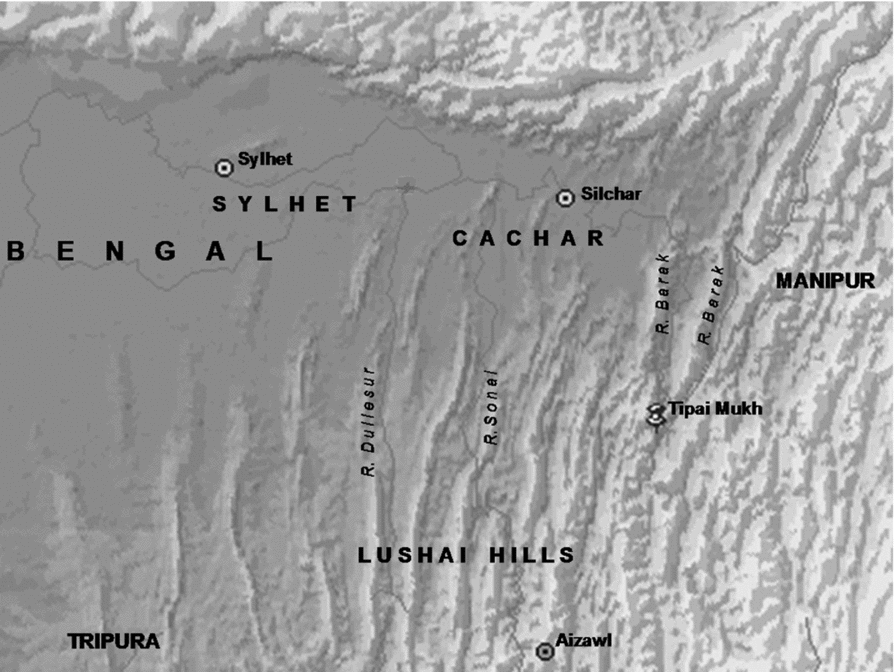
This outlook includes the whole Lushai Hills down to the sea. Taking all of this over was, however, considered to be impracticable and impolitic by the government. Further research by J. W. Edgar, who succeeded Stewart as Deputy Commissioner, deduced that the Kukis were historically ‘independent tribes’ not under the control of Tipperah, Cachar, and Manipur states, and that, ‘Neither the Cachar nor the Manipur chief had the slightest authority in the hills south of Tipai Mukh and it is evident from all the early Cachar traditions that they did not claim any’.Footnote 87 Hence, Tipai Mukh (see Figure 2) was the point from where Cachar boundary had to be defined.
The frontier of Sylhet-Cachar districts with the Lushai Hills.
Source: Re-drawn by author from Microsoft Encarta Reference Library 2005.
Such interpretation of pre-colonial history in the region was significant. Tipperah had historically laid claim over all the territories west of the Barak river no matter how strong its actual control was. Tipperah history was closely associated with the Kuki tribes and it is thus recorded in the royal chronicles (Raj Mala) that they supplied fighting forces, opposed it, paid homage, or even associated with the Kukis in their celestial world.Footnote 88 In the eyes of the Kukis, such a representation of their territory profoundly undermined their own territorial claims in two ways. First, Tipperah and Manipur states were already isolated by way of rewarding them with territories where the hills merged with the Cachar plains, in the west and in the east respectively, and hence were the ultimate beneficiaries of the colonial-defined geographical boundaries; and second, the extension of the Cachar southern boundary to Tipai Mukh—a trading mart under the control of the hill chiefs where they allowed the plainsmen to bring their goods for exchange—ultimately settled the southern boundary of Manipur and Cachar; both were in the heart of Kuki country. Also, Cachar's western boundary with Tipperrah was decisive in settling the eastern boundary of the Tipperah and Chittagong Hill Tracts with the Lushai Hills. This again cut across the ‘hunting ground’ of the Kukis. Hence, Tipai Mukh became the starting point in the negotiations concerning the difficult boundary question.Footnote 89 But the fact that the plainsmen had not inhabited the area was explained away in terms of the Kuki raids which had therefore rendered the border areas uninhabitable:
But it is probable that previous to the Burmese invasions both Cachar and Manipur were able to protect their own people. . .but for many years previous to the death of Gobind Chunder, Raja of Cachar, in 1830, neither state was able to afford any protection against the independent hillmen. . .and at last the Bengali settlers in the south of Cachar were attacked and driven out of the cultivated lowlands near the hills.Footnote 90
Although on the one hand the theory that in all probability the earlier settlement boundaries of the plainsmen did stretch to the foot of the hills was justified, on the other hand, such a theory did ridicule the claims of the hillmen. If the theory portrayed the hill tribes as ‘barbarians’ (a shorthand for unwelcome intruders), this reinforced the notion that they were illegitimate claimants over the territory under dispute. By instating Cachar, Tipperah and Manipur states as the rightful authorities over the ‘hunting ground’, such claims opened the way for the colonial state legitimately to take over the territory claimed by the Kukis and to become the rightful successor state.
Familiar terms of legitimization were deployed to dismiss the claims of the hillmen. The tracts over which the hillmen laid claim were represented as ‘forest’, ‘uninhabited and uncultivated’ land, or ‘hunting ground’, which comfortably sat under the heading of ‘wasteland’. Such discourse is significant particularly when seen from a colonial perspective. Under the colonial ‘rule of property’, forested zone that was not inhabited and which was uncultivated by anyone ultimately was taken to be at the disposal of the state which claimed sovereign right over it. Again, hunting, in the colonial perspective, was a pastime or amusement, but could never be an economic process. Taken from the Kuki perspective, however, we have noted that their hunting ground was very much part of their economy and the territory they preserved for hunting and other purposes was theirs. Hunting in the Kuki perception, was neither a pastime nor an amusement, but formed a vital part of their regular economic processes, in which male were regularly engaged with bringing the much needed animal protein to their family. A Kuki adage, for instance, captures this: ‘A man should spend his life in fighting, hunting, and drinking, whilst [other] labour is intended for women and slaves only’.Footnote 91 Likewise, it was noted in most colonial accounts that whereas women carried out most of the economic activities, both domestic and outdoor work like jhum cultivation, the male folk were seen to be engaged only in hunting and fighting which were, nevertheless, from the Kuki perspective, the necessary constituents of their existence in the hills.Footnote 92 J. H. Hutton noticed that: ‘Little game survives where the Thado [Kuki] settles’.Footnote 93 In this sense, hunting can be taken to be their agriculture, and hence their hunting ground their agriculture fields, which again, if taken from a colonial perspective, fell rightfully within their territory. But when the boundary was drawn the colonial perspective prevailed, and the limit of the hillmen's jhum cultivation was taken to be the line where the limit of their boundary would run.
Whilst searching for a central authority in the hills to obtain an amicable boundary settlement, the colonial authority was confronted with dizzyingly complex and divided hill polities. Somehow J. W. Edgar was successful in convincing Rajah Sookpilal to sign over the dictated boundary line in 1871.Footnote 94 Edgar's argument was that the Kukis had a clear concept of boundary and if a neat boundary line is settled with them, it would give security and confidence to the tribes and hence ensure their ‘future good conduct’.Footnote 95 Edgar was right in this respect. But when the dictated line had taken away the Kuki sacrosanct ‘hunting ground’ and greatly threatened their independence, Edgar's idea of security and confidence proved not to concur with that of the Kukis. Thus, Edgar was stunned to find the united forces of the northern and southern Lushais raiding Cachar, Sylhet, and Tipperah soon after he had entered an accord with Sookpilal.Footnote 96 As the colonial state extended its reach deep into hill territory there arose an overlapping zone of sovereignty in the erstwhile terra incognita of the hillmen. It was in this overlapping zone that most of the raiding took place, the facts of which are discussed below. Here, suffice it to say that the dictates of a dominant power, the colonial state, prevailed in the end, and at no time were the Kukis in a position to resist when their country was later annexed by the Empire.
If civilization ended where the hills began in the concept of a ‘core’ civilizational discourse, then we see why the wet rice cultivation zone rapidly extended to the foot of the hills, and that the tea frontiers swept across the lower hill ranges as far as the rivers were navigable. The thin line that extended beyond the earlier settlements, in the midst of the Kuki hunting grounds, has come to be known popularly as the ‘Inner Line’ in 1878, Cachar, and in 1879, the Chittagong Hill Tracts.Footnote 97 Dotted with military outposts along its length, the Inner Line has practically become the ‘iron curtain’ to the frontier populations. But the outer limit of the colonial boundary went much beyond this, deep into the dense jungle along the limits of the Kukis’ cultivation zone. In 1870, the Government of India clarified its position in this respect: ‘between that actual boundary as shown on the maps and the narrower limit to which our real authority is felt and obeyed, there is in Chittagong, as in Cachar and Arakan, a great belt of unexplored and unsettled country’ and whilst no direct jurisdiction should be extended beyond the line of the outposts ‘nothing should be done to give rise to the inference that the limits of the British Empire do not extend to the boundary shown in the maps’.Footnote 98 Until 1872, tea gardens in this zone were just ‘mere specks in the great forests that surround[ed] them’ but by 1895 most of these areas had already been cleared for tea plantation.Footnote 99 Thus, the colonial economic imperatives and tenets of a ‘core’ civilizational discourse came to govern its spatial management of the frontier, and as a result superseded the vernacular notion of space and sovereignty.
The definitive geography outlining the frontier area in the wake of colonial intervention thus extended into the erstwhile terra incognita of the hillmen and rapidly destroyed the century’s-old standing forest for the economic empire. But the story did not end there—it also caused a domino effect on both sides of the new boundary. In the hills, it triggered a chain of warfare amongst the hill people themselves, and typically revolved around the question of jhum land. The need to establish the least forest barrier against the advancing colonial state compelled the northern Lushais to reverse their thrust towards the interior hills, to the south, thus disturbing the status quos so far maintained among the Lushai chiefs. Lister's expedition was followed by the return of Lushai villages, belonging to Mullah and Sookpilal, towards the south.Footnote 100
The suppression of many Lushai chiefs during the Lushai Expedition of 1871–1872, and the extension of the ‘Inner Line’ deep into their territory, caused warfare amongst the hillmen themselves on the question of land and territory. From around 1875–1876, there was continuous warfare between the eastern Lushai chiefs, Poiboi, Lengkam, Lalbura, Chunglen, and Bungte, and the western Lushai chiefs, Sookpilal, Khalgom, Lalhai, and Lenpoonga. During these territorial conflicts all parties sent repeated deputations to Cachar requesting the British government to act as mediator to resolve their conflicts. But they were merely ‘advised to make peace with the other party’.Footnote 101 The hostilities, causing much destruction on both sides, originated from a dispute over ‘the jhum land’ and continued until all the tribes were forced to cease war when the dreaded famine, known locally as mautam (bamboo famine), struck the hills in 1882.
The extension of the colonial boundary beyond the existing settlements triggered several changes in the Chittagong Hill Tracts and Tipperah frontiers, particularly in extending cultivation and settlement range deeper into the hills, hence causing further conflict with the Kukis. The boundary extension in Cachar was accompanied by the transportation of thousands of labourers from different parts of India, who were largely coerced to work in the fast-growing tea plantations in the district.Footnote 102 An estimated 750,000 workers were brought to the Assam tea plantations between 1860 and 1900.Footnote 103 This bewildering mass of people moving to the frontier areas not only altered the existing social and demographic landscape and its earlier symbiotic relationship with the hillmen, but it also made them victims of the border conflicts in the ‘dead zone’.Footnote 104
Another change brought about by colonial intervention in the region was the liberal provision of firearms to the border populations in order to protect themselves from ‘incursions’ by the hostile hill tribes. In the Chittagong Hill Tracts firearms were initially distributed to the hill chiefs and licences granted to others who could afford them, but from 1875, two gun shops were established there under the government officers, when the purchase of firearms from the plain was found to be too expensive to the hillmen.Footnote 105 In Cachar, North Cachar Hills, and Manipur, those Kukis who accepted British authority were settled in the border areas and supplied with firearms to prevent incursions from the hills. They were settled in the Kuki ‘punjees’ of Cachar district, in the Kuki ‘colony’ of the North Cachar Hills, and in the Kuki ‘sepoy villages’ of southern Manipur valley, thus acting as a buffer against incursions by the Lushais, the Angamis, and the Suktes/Lushais respectively.Footnote 106
Instead of bringing peace, these armed ‘colonies’ increased the rate of violence and conflict along the frontier. The Kukis in the settlement ‘colonies’, rather than being the target of the raids, were now in a position to retaliate and attack their fellow Kukis from the interior hills. In this context, many of the border explosions were an extension of the conflicts amongst the various Kuki tribes which the colonial presence had made possible by supplying firearms to one side. The Kukis of the ‘military colonies’ were also employed by the British for many of the expeditions into the hills.Footnote 107 The Kuki Levy, established in 1850, was helpful in policing the northern and southern Cachar borders, and the Kuki ‘military colonies’ were often used to suppress rebellious plainsmen. The Kukis under Chief Munjahow of the ‘punjees’ in Cachar, for instance, were instrumental in suppressing the ‘Sepoy Mutineers’ of Sylhet and Cachar in 1857.Footnote 108
Colonial intervention in the region, therefore, profoundly altered the pre-existing political, social, and economic system. Not to mention the various restrictions imposed by the new regime in the flow of men and materials between the hills and the valley, the ‘inner line’ now acted as a physical and mental barrier between them. More importantly, the ‘new’ system also brought formerly shared resources of the vast Kuki ‘hunting grounds’ under the exclusive control of the state and the tea-planter capitalists. Thus, what transpired from the colonial spatial ideology in the frontier region was not so much the tranquility which it aimed for, but an increasing rate of tension and conflict in the border areas. Kuki raids and British expeditions were just two of the generic problems generated by colonial intervention. The hillmen, it must again be asserted, raided the villages within the compass of their erstwhile ‘hunting ground’, not so much due to their proximity but because they occupied Kuki territory without paying tribute. Perhaps they hoped that these usurpers could still be expelled, and perhaps they recognized that these villages threatened their very existence as an independent state-evading population in the hills.
Raiding the frontier, and defending the hill autonomy
Raiding was now a dangerous business for the hillmen. Not only was great risk attached to traversing the deadly jungles (which usually took several days), but also raiding in British territory amounted to a declaration of war against the mighty British Empire, whose reaction was usually brutal. Besides, raiding could also involve contracting dreaded and ritual-proof ‘foreign’ diseases such as cholera or smallpox and transmitting these into the hills.Footnote 109 Raiding was therefore only carried out when absolutely necessary. The Kukis usually took captives, heads, and booty during the raids. Discussion here about the plundering and taking of captives to provide labour in the hills as perhaps the only motive behind the raids (which has been discussed elsewhereFootnote 110) would decry the importance of what we are actually concerned with here: that the raids were mainly to defend the autonomy of the hillmen, their territory and resources, as well as the prevention of state appropriation. Plunder and the taking of captives, in many cases, were incidental to the raids’ specific purpose. The subtle reasons which really lay behind the raiding varied from the demand of ‘blackmail dues’ (in pure revenge) to resist, or to warn, the encroaching colonial state, the planter-capitalists, the swindling traders, and woodchoppers. All these related to the Kuki claims of authority and to the assertion of their right to the resources of the area.
We have noted that in the precolonial period some of the border zamindars and woodcutters paid certain tribute to the hill Rajahs in recognition of their authority. The hillmen attacked the plains not to claim the tribute but because they were not paid the tribute claimed by them. Pemberton rightly remarked that the plainsmen paid ‘a species of black-mail’ to the hill chiefs ‘to procure exemption from their attacks’.Footnote 111 These people stopped paying the usual ‘blackmail’ after the arrival of the colonial regime in the region; indeed they were ordered not to continue further payments. But if the payment of tribute prevented raiding, then its stoppage would most likely initiate a raid. This was the case in the Sylhet and Cachar frontiers.
The earliest recorded case of what may be called ‘blackmail’ death came in 1826: a party of Sylhet woodcutters was massacred by the Kukis under chief ‘Buntye’ (Buntai). Three messengers, who were sent by the Magistrate of Sylhet, confirmed that the cause of the outrage was ‘that the zamindars of Pertabgur had withheld the annual presents’ which they used to pay to the Kuki chiefs. Two of the messengers were held hostage, and the third one (after being allowed to inspect the ghastly heads of the woodcutters), was sent back to the plain ‘to bring up the blackmail due’.Footnote 112 For the sake of the two hostages the demand was later sent up, but vigorous vigilance and the closure of border markets to the hillmen followed this incident. We have already seen that the dense forest tract of the Sylhet frontier became the ‘hunting ground’ of the Kukis when the British moved in. This was now cleared for cultivation by settling the ‘lowlanders’ there. In order to diffuse opposition from the hill chiefs, the zamindars paid them tribute.Footnote 113 But from around 1822, after the boundary was settled with Tipperah, these tribute payments ceased, and this appears to be one of the main causes of the subsequent raids and ambushes upon the plainsmen.Footnote 114 These raids and ambushes, which included the killing of woodcutters in 1826, was, therefore, connected to the claim of territory and was essentially an expression of hill authority against encroachment by the plainsmen and the British.
The conflict over territory and resources is more clearly illustrated in the border areas of the Chittagong Hill Tracts and Cachar. Chittagong was acquired by the East India Company in 1760. It included the hill tracts in its eastern frontier. Initially the Chittagong Hill Tracts were administered from the plains but it was accorded a separate district status under the Act XXII of 1860. Frontier outposts were gradually established at the margins of the settlements under a popularly known ‘policy of vigilant and vigorous defence’ against incursion by hostile Kuki tribes. Until 1870, when a clear direction was given to concentrate the colonial jurisdiction within the frontier outposts, it was thought that such jurisdiction extended beyond the outposts to the limits of the boundary as shown in official maps.Footnote 115 This encouraged the inhabitants of the Chittagong Hill Tracts to extend their settlements and jhum cultivation into the interior hills, beyond the outposts, and hence brought them into conflict with the Kuki Rajahs who claimed authority over the territory.Footnote 116 In the cold season of 1849–1850, the Shendus attacked the Phru country, and the Lushais the Chakma villages north of Karnafuli. The reason for these raids was, as noted by the Magistrate of Chittagong, ‘due to the encroachment of the Mugh Joomeas upon the territory belonging to the hill tribes’.Footnote 117 It is no wonder that in 1854 the Superintendent of Police reported that there were 19 raids in the Chittagong frontier during ‘the past seventeen years’, in which 107 people were killed, 15 wounded, and 186 taken into captivity.Footnote 118
Raids were especially prominent during the 1860s mainly due to the conflict between the Poang chiefs and the Kukis over the Sungoo valley where Joomeas, after gaining much strength with the increasing supply of firearms, extended their settlements deep into the hills. On 9 July 1866, the Howlongs (Hualhang, a Sailo chief) attacked the Poang villages close to Khokheong, in which three villagers were ‘cut up’ and 80 captives carried away. The same band also committed two more minor raids in the village of Kwasa Khung and another in the Kaptai valley.Footnote 119 The Bungjogis of Poang responded but were beaten back, only to be followed by a reprisal from Howlongs in January 1867, who appeared between the posts of Chima and Khokheong and ‘cut up’ several villages and retreated, as usual, before the police could intervene. Sungoo valley was the point where the Howlongs generally advanced at this time.Footnote 120 Similarly, the Sailos, under Rajah Zaroka, and Lalpunga committed the dreaded raids in Upper Chengri Valley in 1889, where 24 villages were ‘cut up’, 101 people killed, and 150 persons were taken into captivity. They were a mixed group of Tipperahs, Riangs, and Chakmas who had broken away from their headmen and comprised mostly ‘bad characters’ and those who occupied the tract over which Zarok (Zaroka) ‘asserted his rights’ as his ‘elephant hunting ground’.Footnote 121
The heart-rending stories of the border explosions of 1868–1869 and 1871 in Cachar, Sylhet, and Tipperah, which led to the Lushai Expedition of 1871–1872, are also instructive. We have already noted that the discovery in 1855 of the indigenous tea plant in Cachar was swiftly followed by the planting of sprawling tea gardens in the southern part of Cachar district. The extension of the tea gardens in this area, Reid has noted, brought ‘a disquieting effect upon the neighbouring Kukis who fancied them as possible encroachments upon their hereditary hunting grounds’.Footnote 122 In 1866, the emissaries of some Lushai Rajahs came to Captain Stewart at Silchar and ‘complained of the extension of tea gardens to the south as likely to encroach on their hunting grounds’. ‘Their real objection clearly was’, Edgar remarked, ‘that the advance of our cultivated frontier sensibly narrowed the belt of seemingly impenetrable jungle between them and us’. Stewart told them that ‘tea cultivation would doubtless extend as far as the streams were navigable’, but pointed out that the Lushais would benefit greatly from it.Footnote 123
Stewart's answer was plain enough to the Kukis that the expansion of tea gardens could not be stopped through verbal negotiation. Their apprehension peaked when a survey party made an inventory of their ‘hunting grounds’ in 1867–1868. Many of them had already shifted their villages further southwards in anticipation of the conflicts.Footnote 124 Such apprehensions culminated in raids on tea gardens at Loharband and Monierkhal in 1869. This was followed by John Edgar's historic tour across the northern Lushai Hills in 1870–1871, in which he apparently reached an agreement with Sookpilal on the boundary question between Cachar and Lushai country. However, the situation that unfolded after this agreement suggests that the boundary line, which took away the ‘hunting ground’, was not acceptable to the Kukis.
When Edgar was still in the hills, a series of raids were undertaken in the plains ‘on a more extensively organized scale, and of a far more determined character, than any previous incursions of the kind’.Footnote 125 The ferocious ‘outrage’ in 1871 singularly targeted the tea gardens and their establishments at Cacharee Punjee, Alexandrapore, Cutlicheera, Monierkhall, Darnierkhall, Nundigram, Jalnacherra, and Cacharipara. The assailants also attacked the road construction party, the coolies, the police outposts, and the police patrolling party.Footnote 126 The targets were clear: the symbols of British power and presence in the areas. Contrary to earlier raids, this particular one was carried out by the Lushais of the north Lushai Hills ‘in concert’ with the southern Lushais.Footnote 127 Reid has noted that the uprising was due to the ‘alleged grievance’ of the Kukis against the tea planters for clearing the forests along the Cachar frontier under the promise of protection by the civil authorities, ‘in tracts which were claimed by the former as their rightful hunting grounds, although regarded by us as well within the newly defined line’.Footnote 128
The Chin uprisings of 1887–1888 also exhibited another case of resistance to colonial over-reaching.Footnote 129 In May 1887, the Tashons raided Indin, Chingaing and two other villages; the Hakas and Yokwas attacked the Yaw country; and the Siyins the plains. In October 1888, the Tashons committed one raid, the Siyins five, and the Suktes one, and within 12 days 122 Shans were carried off, 12 killed, and 14 wounded. Khampat was ‘entirely destroyed and Kalemyo lost 35 houses by fire’.Footnote 130 From January to March 1889, the Siyins committed nine raids, the Sagyilein two, and the Kamhows 20, upon the Burma plains.Footnote 131 Charles Crosthwaite, Chief Commissioner of Burma, noted: ‘the origin of the disturbance must be sought in our action in the cold season by which we alarmed and roused the suspicion of the Chins by a premature attempt to discover a route through the hills to Chittagong’.Footnote 132
Colonial intervention in the frontier areas had also animated tension in other ways. In the celebrated case of the 1844 Kochabari raid in Cachar, where 20 people were killed and 6 taken captive, Rajah Lalchookla (Lalsukhla), after his surrender, admitted freely before Captain Blackwood, and at Sylhet before the Magistrate, that he attacked the said village ‘to take revenge on the Munipoorees [Manipuris] for the murder of his father [Laroo]. . .by the Munipooree chiefs Ramsing and Tribujeet’ in 1841 and ‘said he knew not they were subjects of the Company’:
I did not go to the Kochoo barree myself. Fifty of my men went by my order, the Munipooree Chiefs Ramsing and Triboujeet came into my country and murdered my father Laroo, his Wazeer Nazir and 60 of his people about four years [ago], since I considered all Munipoorees as dependent on the Rajah of Munipoor and therefore sent to Kochoo barree to take my revenge.Footnote 133
Lalchookla came to trial under colonial law, and his punishment was to be transported for life. But this incident is particularly significant on two grounds. First, there were great anomalies in the understanding of, and in handling, the issue by the two contending parties, and secondly, and as a logical outcome to the first, it triggered more conflict on the frontier. From a Kuki perspective, Lalchookla made two important points to justify his actions. First, he honestly confessed that he thought the Manipuris were the subjects of Manipur Rajah, not knowing they were British subjects, despite the fact that they lived in British territory. In this sense, the role of colonial authority was not anticipated. Here, the Kuki notion of sovereignty over the people, not space, as noted earlier, was clearly manifested. Secondly, he justified his action as ‘revenge’ against the attack on them by the Manipuris in the first instance. In this context, the problem was settled, from a Kuki perspective, by the action of revenge itself and no further issue should arise from it. Even after realizing that the colonial authority was handling the case, Lalchookla surrendered when he was promised his life. In his perception, or more properly, in the perspective of the Kukis, sparing a life means a pardon and indeed he might have hoped that the matter would be settled politically between the two independent powers, so that the Manipuri's attack on his village would also come within the purview of the negotiations. But unfortunately the emerging colonial laws belied all his expectations and he was punished in the same way as any other common criminal in the British Empire.
Here, colonial spatial ideology and its hill-valley binary played a vital role. Harping on its civilizational credo, ‘raids’ committed by the ‘savage barbarians’ could never be settled by political negotiation. This was because it was assumed that the outrage was committed for procuring human heads for the chief's funeral rites.Footnote 134 This particular notion even led the British favourably to regard even those raids undertaken earlier by its subjects upon the ‘barbarians’. Hence, the attack by the ‘governed’ Manipuris upon the ‘savage’ Poitoo village was not even an issue in the trial process. No wonder not even an eyebrow was raised at the massacre of 40–50 people of Mullah's village during the Lister Expedition of 1850.Footnote 135 Indeed, such a civilizational approach to the problem of the frontier areas caused much disappointment to the hillmen, and instead of bringing tranquility it dangerously heightened conflict amongst the frontier populations.
In fact the Kukis already held many grievances against the Manipuris of Kochabari long before the ghastly incident took place in 1844. In 1834–1835 Tribojit, an exiled prince of Manipur, had been granted a piece of land at Jafferbund by the British authority, along with taqavi (loan) advances, 12 muskets, and the rights to levy a tax on all goods coming down Dullesur river, mainly ‘to keep the Poitoo Kookies in check’. This altered the existing situation on the frontier: first, by occupying the land over which Poitoos claimed authority, and second, by obstructing the free flow of goods and men between the hills and the valley. Enquiries had shown that those Kukis who used to come down to Kochabari bazaar were often cheated and beaten up; on one or two occasions the Manipuris had even attacked the Kukis in their own villages.Footnote 136 J. P. Wise, the Officiating Magistrate of Tipperah, noted that ‘the row [1844 raid] was the consequence of repeated oppressions on the part of the people below taking their Hill produces [sic] and not paying for it’.Footnote 137
The singular target of Kochabari village was, therefore, closely connected to the altered situation under colonialism. For not being within the charmed circle of ‘civilization’, Lalchookla was arrested, put on trial, convicted, and was transported for life. Instead of bringing peace, this move animated conflict in the frontier, particularly when Lalchookla's son, Gnurshailon (Murchuilal), swore ‘to take vengeance’ on British territory.Footnote 138 To the Kukis, noted Edgar, Lalchookla's transportation was a ‘breach of faith’ and they felt deceived by the severity of Lalchookla's sentence. Lalchookla's deportation was followed by a ‘series of massacres’ in 1847 by his son Gnurshailon against Lallme Sing who had been instrumental in capturing Lalchookla.Footnote 139 In 1849 this was followed by a massacre of woodcutters.Footnote 140 The ‘Adampore massacre’ of 1862, carried out by the Poitoos in league with the Lushais, was also connected to this grievance.Footnote 141 In fact, Lalchookla's deportation set the precedent for the Kuki chiefs neither to submit before the colonial authority, nor to come forward in negotiation. This initial folly by the British was, however, realized later, and hence promises of safe conduct were repeated at frequent intervals to bring them to the negotiating table, which worked well in resolving many frontier issues.
Similarly, in the celebrated case of the ‘Great Kookie Invasion’ of 1860, where 15 villages were plundered, 185 people killed, and about 100 persons taken captive, it was believed that the Kukis raided due to ‘ill-feeling’ caused by the Tipperah Rajah which unfortunately spilled over into into British territory.Footnote 142 ‘I think’, remarked J. D. Gordon, Officiating Magistrate of Tipperah, who investigated the case, ‘that to revenge the raid on the Dooptungs [Kukis] by the [Tipperrah] Rajahs people was the object of the rising of the Kookies; that the disaffected Reangs and Chuckmas (the Kalindee Ranee's people), headed by the Thakoors, caught up the spirit, and caused plunder and murder on all sides’.Footnote 143 The expedition under Captain Raban destroyed Rottun Poe's village who was instrumental in the attack but he was later forgiven when he chose to become friendly.
Indeed, lessons learned from the mistake at Kochabari brought a good ally in Rottun Poe, who was instrumental in bringing many more chiefs to the British annual political mela at Kassalong. Whilst the Raban expedition was marching against Rottun Poe in 1861, at the same time, the Oodoypore raid was taking place in Tipperah where several villages and wealthy marts and a British outpost at Kurkurea were attacked, killing 150 people and capturing 200. It is believed that this attack was also due to the ill-feeling caused by the Tipperah Rajah's 1860 ‘invasion’.Footnote 144 ‘I learn’, noted Gordon (who investigated the cause of the attack in 1861), that ‘what I did not know last year, what I could not have learnt but at Oodaypore, that the bringing about [of] the attack upon the Dooptungs by the Jamatyas by the Rajah's order[,] much faithfulness was exhibited’.Footnote 145 Thus, revenge against an attack by the other has again emerged as the cause of the raids.
The Soktes, Siyins, Yokwas, and Hakas had also initially raided the Burmese villages in revenge. The first two tribes, claimed that they raided in revenge for the murder of their convoys by the Burmese whilst they travelled to the Sawbwa court. The Yokwas began raiding because of the treachery of the Burmese who had murdered their people when they were actually there to help in the fight against Burma's enemies. The Hakas declared war on the Burmese when the latter assisted the Thettas in attacking the Haka.Footnote 146 In Manipur, the murder of Rajah Nehlam, pipa (head) of Haokips, by a Manipuri high official and son-in-law of the Maharaja whilst he was supposed to be under safe conduct guaranteed by the Political Agent, was considered to be the reason for the Chassads’ raids in the eastern frontier.Footnote 147 Similarly, the number of Guite-Sukte raids measurably increased after the death of Rajah Kokatung (Goukhothang), pipa of the Guites, whilst incarcerated at the Imphal jail in 1872. He and 56 of his warriors had been ‘treacherously’ captured by the Manipuri forces at Sitol Subbom in 1872, whilst escorting 962 of his people who had escaped from the Lushai Hills during the Lushai Expedition, 1871–1872.Footnote 148
The market places, and similar venues, could equally be sites for plunder as much as sites for peaceful contact and negotiation between ‘civilizations’ but, more importantly, could also be sites of unequal economic exchange.Footnote 149 In the colonial civilizational construct, these were the places where the hillmen were viewed as ‘specimens’ of the ‘old world’, where they had formerly been viewed as lords. This notional change under the colonial regime, especially with the advent of the bewildering mass of people from different backgrounds (as in Cachar), was likely also to have contributed towards heightening tension in the frontier. This is illustrated by frequent and often brutal attacks upon market centres. Kochabari, in the Cachar-Sylhet frontier, was one such place where a raid took place in 1844. In January 1850, the Kukis attacked the villages of Kalindi Rani's people in the Chittagong Hill Tracts, against ‘the imposition of frauds practiced on them when trying to barter their hill produce for salt and other articles brought from the plain’.Footnote 150 The plundering of Changsil bazaar in Cachar in October 1879, as well as the raids on Indin, Chingaing, Khampat, and Kalemyo, in the Burma plains, can also be safely placed in this category,Footnote 151 alongside the ‘Great Kookie Invasion of 1860’, and the attack on the wealthy Oodoypore areas and its marts in 1861.Footnote 152
Conclusion
What inferences can be drawn from the above discussion? The world described here was enveloped by Empire in 1892–1893 and raiding ceased after that. Before this, raids and expeditions were the usual practices adopted, respectively, by the Kukis and the British when negotiations failed. The vital point to these conflicts was its relation to Kuki views about the extent or limit of their territorial space. To the tribal Kukis, the limits of their territory included the outer limits of their ‘hunting ground’. The colonial authorities, in contrast, believed that the limits of Kuki territory were at the margins of their jhum fields, and hence that their hunting ground, which was ‘uncultivated and uninhabited’ forest, should therefore ultimately be under state control. The dense forest cover, which had so far been preserved and protected by the hillmen, was seen by the British, driven in part by economic interest, as a source of timber, bamboo, rubber, and war elephants. When tea was also discovered as indigenous to Cachar, nothing could stop the colonial state from acting territorially to utilize this resource economically in the ‘interest of tea’. Thus, the colonial boundary was extended deep into the hills and ultimately decimated the hill curtain that had previously guarded hill autonomy. A line of military outposts (an ‘iron curtain’) protected the state areas, wet rice cultivation now extended to where the hills began, and tea gardens proliferated across the hills up to where they could profitably be cultivated. Raids and expeditions were just one part of the dizzyingly rapid change the new colonial project wrought on the frontier region. Colonial intervention in the general area, as well as militarization of the borders, triggered warfare amongst the hill tribes, the mass influx of transported people caused discontent, the replacement of the age-old, shared forest cover with privately owned agrarian fields and tea gardens or ‘reserve forest’ now brought under the rule of the colonial state—all these factors altered the symbiotic hill-valley relationship, and ultimately replaced local polities, society, and culture with the colonial order.
Kuki raids in the nineteenth century must, therefore, be understood as acts of resistance against colonial encroachment over a territory to which they laid claim. Yet what transpired is that the hillmen rarely raided upon British territory without first trying some sort of negotiation before risking an attack that might meet an overwhelming response. Kuki raids may therefore be understood as the ‘rarest-of-the-rare-cases’. They were indeed the last resort at the disposal of a ‘not-a-state-subject’ people against state expansion and appropriation, and were an expression of extreme discontent. To the Kukis, the destruction of their hunting ground—which has been described here as the ‘hill curtain’, the purveyor of their independence in the hills—was a question of their very survival, and hence raids were an extreme response to an extreme situation. In this context, the raids were premeditated and a conscious undertaking on the part of the Kukis, instead of mere ‘cold weather amusement’ as has been generally understood. The raids were also a strategy employed by a non-state people to divert and delay the advancement of colonial state expansion into the hills, just as burning villages or mercilessly killing the inhabitants has become a strategy employed by some post-modern rebels in the region, to draw the attention of the post-modern state to their plight.