Introduction
Until about 1870 there were no complete charts of Svalbard and Novaya Zemlya or, indeed, of much of the Arctic. In the ten years from 1865 to 1875, however, sealing masters of the northern Norwegian fleet updated and made new charts of Kong Karls Land, Nordaustlandet and Novaya Zemlya. This work was part of a continuing process that, indeed, continues to this day. Willem Barentsz mapped the west and north coasts of Spitsbergen in 1596 and the British whaling master Thomas Edge discovered and plotted Edgeøya in 1616 and Kong Karls Land (which he called Witches-Iland (Conway Reference Conway1906)) in 1617. From 1721 to 1736 the Norwegian missionary Hans Egede ‘made important contribution to the understanding of Greenland's geography’ (Gyldendal 1972) and some 100 years later William Scoresby made charts of Jan Mayen and part of the east coast of Greenland. In this way these men, and Flemish navigators like Cornelius Gille and Jan Jacobsz May, contributed to knowledge of the Arctic. Quite exceptional, however, was the way in which scientific institutions in Scandinavia engaged sealing masters to carry out special tasks for them: to cut and collect specimens of rocks, to gather plants and animals and to record hydrographical, oceanographic and meteorological data. This paper examines the co-operation between such scientific institutions and the sealing trade regarding cartographic work carried out by sealing masters in the late 19th century. The geographical results have been outlined in Hoel's (Reference Hoel1945) monograph although without reference to source material. The present paper is based entirely on original sources. It is conceivable that Hoel had seen some or even most of these but this is not known. The present study extends Hoel's work by describing the influence of a scientific network in Norway and Sweden whose members saw the value of the masters’ knowledge of the Arctic and actively encouraged them to record their observations and to gather scientific data.
Edvard H. Johannesen: pioneer in Novaya Zemlya and Greenland
In 1867 the Norwegian sealing master Elling Carlsen discovered walrus grounds on Novaya Zemlya and in the following years ‘. . . every vessel fit for the sea was equipped for the Kara Sea. It swarmed with vessels’ (Feddersen and Nissen 1928). One of these was the schooner Nordland that sailed to Novaya Zemlya in 1869 captained by the 25 year old Edvard H. Johannesen.
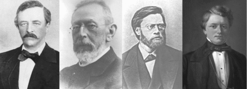
Johannesen made notes on the weather, barometric pressure, sea temperature and currents, took soundings and recorded incidental observations such as the occurrence of fishing floats from the Lofoten Islands, a coconut and other objects which had drifted ashore. On his return to Tromsø he showed his notes to Adolph Ebeltoft, a lawyer and Adolf Nordenskiöld's agent in Norway (Fig. 1), who was a friend of the Johannesen family. Ebeltoft noticed that Johannesen's data indicated that the waters off Novaya Zemlya were swallower than previously reported and, more importantly, that the islands were further north and west than on the Dutch chart based on William Barentsz's account (Ebeltoft Reference Ebeltoft1870a). Ebeltoft sent this information to the authorities in Holland responsible for the Dutch chart and also persuaded Johannesen to send his notebook to Nordenskiöld. The latter was impressed by it and encouraged the young skipper to continue recording his observations (Ebeltoft Reference Ebeltoft1870a). Johannesen's data were published in the journal of the Royal Swedish Academy of Sciences the following year (1870) and he was awarded the Academy's silver medal (Nordenskiöld Reference Nordenskiöld1881:282). Nordenskiöld wrote ‘You might expect another medal - in gold - when you circumnavigate Novaya Zemlya.’ Johannesen took this as a challenge, although Nordenskiöld subsequently stated that it was merely a pleasantry, and set off on a second voyage to Novaya Zemlya.
Left to right: Adolf Nordenskiöld, Henrik Mohn, Karl Pettersen and Adolph Ebeltoft. These four men formed a highly productive Arctic science network. (Photo of A. Ebeltoft courtesy of Sveinulf Hegstad, Tromsø Museum. Nordenskiöld, Pettersen and Mohn courtesy of the Norwegian Polar Institute, Tromsø).

Johannesen continued to collect data during his 1870 voyage, recording air and sea temperatures, salinity, the colour of the sea, types of growth on the sea floor, different kinds of drift wood, fishing nets and other objects that had drifted ashore ‘carried by the Gulf Stream’ (Nordland 1873). On 11 August, although loaded with seal and walrus hides and blubber, Nordland continued north along the coast of Novaya Zemlya. On 3 September she passed the northernmost point and on 17 September, just two weeks later, the schooner dropped anchor in Tromsø having completed the first circumnavigation of the islands (Nordland 1873). Once again Johannesen showed his observations to Ebeltoft and described what he had achieved on the expedition. Ebeltoft wrote to Nordenskiöld: ‘As you may recall, sealing master Edvard H. Johannesen received a silver medal for his observations in the Kara Sea and you said that he would probably receive a golden medal if he circumnavigated Novaya Zemlya. This has just happened!’ (Ebeltoft Reference Ebeltoft1870b).
Johannesen's new data indicated that Novaya Zemlya was larger, wider and further north than indicated by contemporary Dutch and Russian charts. Ebeltoft therefore arranged for Johannsen and Iver Christian Hansen, Johannsen's teacher at the navigation school in Tromsø, to make new chart of Novaya Zemlya based on Johannesen's observation book and the ship's log. Hansen sent a draft of the new chart to Nordenskiöld at the University of Stockholm. The following year (1871) Nordenskiöld published the new chart of Novaya Zemlya in Petermanns Geographische Mitteilungen and sent Hansen several copies to sell and thus recoup his expenses (Ebeltoft Reference Ebeltoft1871). Johannesen's observations were also published in the journal of the Royal Swedish Academy of Sciences as ‘Hydrological observations made during a hunting voyage around Novaya Zemlya’ [Hydrografiske Iagttagelser under en Fangstur rundt Novaja Semlja] Nordenskiöld Reference Nordenskiöld1881: 283) and on 11 January 1871 he was awarded the Academy's Linné Medal in gold for having completed ‘a voyage that geographical authorities had considered impossible a few years ago’ (Nordenskiöld Reference Nordenskiöld1881:283). Johannesen received the medal at a reception in Tromsø led by Ebeltoft who used his speech to encourage sealing masters to record their observations at sea and ‘to continue to try to push farther and farther north and into the ice’ (Ebeltoft Reference Ebeltoft1871).
An interesting aspect of the progression from Nordenskiöld's pleasantry to Johannesen's being awarded the Linné Medal is that his was not the first circumnavigation of Novaya Zemlya. That honour is credited Savva Loschkin, a native of Olonets, who sailed round the islands between 1760–1762 (Nordenskiöld Reference Nordenskiöld1881). Whether this was known to Nordenskiöld at the time is not known. Assuming that it was, his subsequent support for Johannesen must be credited his appreciation of the fact that the data gathered by the young master led to a major revision of existing charts of the islands.
Other awards followed. In 1872 he received the French De la Rogetta medal in recognition of his circumnavigation and his contribution to polar science and in 1877 he received a silver cup from The Royal Swedish Academy of Sciences for having sailed to Dikson harbour in Russia and collected geological specimens (Ebeltoft Reference Ebeltoft1877). Edvard Johannesen was probably the Norwegian sealing master most decorated for his service to science.
Johannesen is best known for his discoveries at Novaya Zemlya but he had other points to his credit. Fridtjof Nansen's demonstration during the Fram expedition (1893–1896) of the existence of a south westerly current along the east coast of Greenland attracted considerable attention and remains a great contribution to oceanography (Kjær and Foxworthy Reference Kjær and Foxworthy2004) yet Edvard Johannesen has a prior claim. He discovered the East-Greenland Current in 1891 and described it in detail in the log book of the sealer Colibri and in his ‘July report’ for that year (Colibri 1891). His principal parameter was the colour of the sea and he reached his conclusion after comparing his observations in 1891 with the observations and notes he had made when sealing in the Danmark Strait onboard the schooner Nordland in 1874. He made two supplementary observations. First, he found a plank 26 ft long and 13 inches wide in the Greenland Sea with marks on it which he identified as those of a Siberian sawmill which had closed in 1879. He concluded that the plank must have drifted across the polar sea. Second, in his ‘May report’ he mentioned sea ice covered with brown sand probably ‘carried from Spitsbergen or Greenland’. Unfortunately Johannesen did not publish these observations. He correctly submitted his report to Fredrik Collin and Daniel Mack, the owners of Colibri, but they paid no attention to his observations which were subsequently forgotten. Their value today lies not in their contemporary novelty and scientific precedence but, instead, in the way in which they illustrate the remarkable power of observation and deduction of this remarkable man.
Erik Ulve's chart of Nordaustlandet
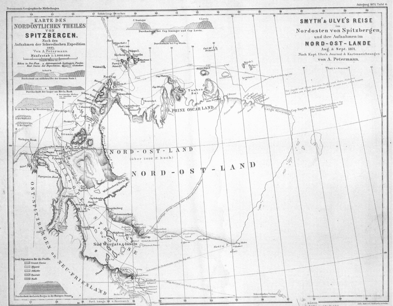
On 17 June 1871 the schooner Samson sailed out of Tromsø with a crew of 14, including five Norwegians, bound for Svalbard. Her master was Erik Ulve, 38 years old and former master of the sealer Island (that is the Norwegian spelling of ‘Iceland’). Samson was owned by the British Arctic explorer Benjamin Leigh Smith who was leader of the expedition. Samson sailed through Hinlopen but was hindered by ice at Lågøya. In August she continued north and on 10 of September she reached 81° 24’ 24” N., 18° E. The expedition failed to find Gilles Land, its stated objective, but it did yield a new chart of Nordaustlandet and it demonstrated that Svalbard extended 4 degrees of longitude further east than indicated on the old chart, although, in fairness, the old chart was largely correct once the east coast of Nordaustlandet was extended by these four degrees (Capelotti Reference Capelotti2006). Samson returned to Tromsø on 27 September and Ulve sketched a chart of Nordaustlandet with 33 new place names. He sent this to Henrik Mohn, the director of the Norwegian Meteorological Institute (NMI; Fig. 1), together with a copy of the ship's log book. Mohn published a new map of Svalbard based on Ulve's information and Otto Torell's map published ten years previously in Petermanns Geographische Mitteilungen (Fig. 2).
Mohn's map of Nordaustlandet, after Captain Erik Ulve's journal and sketch from August and September 1871, published in Petermann's Geographische Mittheilungen. The new chart shows that Nordaustlandet reached four degrees of longitude further east than on the old chart. Smith, that is Benjamin Leigh Smith, is erroneously given as ‘Smyth’. From Feddersen and Nissen's archive (Courtesy of Wenche Nissen, Oslo).

The first map of Kong Karls Land
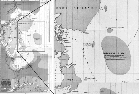
In summer 1872 the sloops Lydianna (Nils Johnsen), Elvine Dorthea (Johan Altman) and Freia (Johannes Nilsen) sailed in convoy through Storfjorden to Kong Karls Land to hunt walrus and seal. No chart of Kong Karls Land existed at that time (see Fig. 3) so the three masters took notes and made sketches of what they saw during the voyage. The problem on their return was what use to make of these data.
An 1872 chart of Svalbard based on data from E. Ulve and T. Torkildsen and published by Petermann's Geographische Mittheilungen. It is evident that Kong Karls Land was known but not mapped. From Feddersen and Nissen's archive (Courtesy of Wenche Nissen, Oslo).

In the 1870s there were few persons with higher education in northern Norway. Most sealing masters ‘had no knowledge of navigation other than what they put into practice on their voyages to Spitsbergen’ (Finnmarkposten (Hammerfest) 1 November 1866) and to convert their raw data into a map the three masters required help. Nils Johnsen contacted Johannes Musæus Norman, a forester who, in turn, took the notes and sketches to Iver Hansen, at the navigation school, who used them to draw a map. Johan Altman contacted Lt. Mathisen and he, too, drew a map based on Altman's notes and the ship's log. Johannes Nilsen and Carl Wiig, the master and mate of Freia, contacted Ole Lund, a lawyer in Hammerfest, but he had no knowledge of navigation and could not assist directly. Nevertheless, he examined Nilsen's notes and the ship's log, interviewed Nilsen, Wiig and the rest of the crew and wrote a report that he sent to Henrik Mohn at NMI, noting that Nilsen had circumnavigated Kong Karls Land in convoy with Altman and Johnsen.
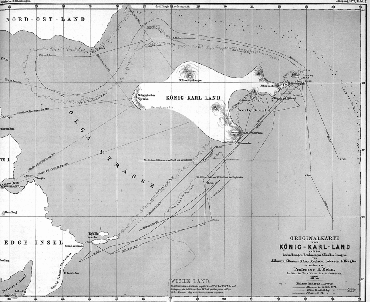
Mohn received Lund's report and Hansen's and Mathisen's sketch maps and he observed to his astonishment that there was little discrepancy between the two maps (Mohn Reference Mohn1873a). Mohn combined them with data from Captain Carlsen's log book, Sivert Tobiesen's report from the voyage of the brig Jan Mayen in 1859 and Baron Theodor von Heugin's report from the voyage of the schooner Skjøn Walborg in 1870. With this material he produced a new map of Kong Karls Land which he published in 1873 (Mohn Reference Mohn1873b; Fig. 4). His choice of name is interesting. Von Heugin and Count Walburg-Zeil named the archipelago König Karls Land after the King of Würtemburg in Walburg-Zeil's homeland (Kjær Reference Kjær2007) but Mohn named the group Kong Karls Land after the King of Sweden-Norway.
Map of Kong Karls Land (German: König-Karl-Land) based on accounts, sketches and observations by Johnsen, Nilsen, Altman, Carlsen, Tobiesen and Heuglin. Drawn by H. Mohn in 1872 (Mohn Reference Mohn1873b).

Sealing masters engaged by the Meteorological Institute
The Norwegian Meteorological Institute (NMI) was founded as a Department of the University of Christiania (Oslo) in 1866. From its very beginning NMI established close collaboration with masters of the southern Norwegian sealing fleet which sailed to Jan Mayen. Atlantic sealing was a major enterprise. In 1867 the southern fleet, which counted 18 vessels and some 800 men, killed 89,761 seals (Kiær Reference Kiær1871:20). The masters recorded air and sea temperatures.
In 1870 the NMI extended its collaboration to include masters of the northern Norwegian sealing fleet which sailed to Novaya Zemlya. The object was to provide oceanographic and meteorological data that would enable Henrik Mohn, its director, to chart the Arctic extension of the Gulf Stream. The work was co-ordinated by the geologist Karl Pettersen, NMI's representative in northern Norway (Fig. 1). He recruited Edvard H. Johannesen, master of the schooner Nordland, P. Quale, master of the sloop Johanna Marie, Erik Ulve, master of the schooner Samson, Jens Olsen, master of the sloop Hvidfisken, Fritz Mack, master of the schooner Polarstjernen and T. Torkildsen, the master of the schooner Alpha, all of whom were bound for Novaya Zemlya. NMI provided observation journals and written instructions in the form of ‘A Guide to carrying out Meteorological Observation at Sea’ (Isaksen undated) as well as hydrometers, barometers and thermometers. The masters agreed to record cloud cover, air and sea temperatures, barometric pressure, wind, currents and the condition and exact latitude and longitude of sea ice every day and either to send these data to the NMI (Tromsø Stiftstidende 2 February 1871) or to deliver it to Pettersen. Alpha was wrecked in the Kara Sea in June but the crew of 30 was rescued by the sealer Island and sailed home with other vessels. Captain Torkildsen, however, stayed onboard the Island for 10 weeks to carry out the NMI programme (Tromsø Stiftstidende 8 Sept 1870, 19 March 1871).
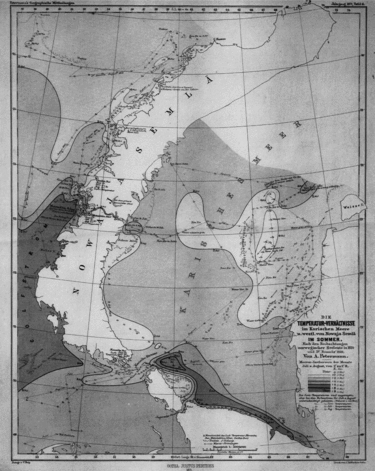
The German institute in Jena made a new chart of Novaya Zemlya and the Kara Sea based on information from the six masters and published it in Petermanns Geographische Mitteilungen over the text: ‘Chart of the Kara Sea and the condition of temperature in summer based on observations made by Norwegian sailors in 1870’ (Fig. 5). The NMI formally acknowledged the masters’ contribution to science on the front page of the newspaper, Tromsø Stiftstidende (Tromsø Stiftstidende 2 February 1871).
Chart of the Kara Sea with summer sea temperatures. ‘Nach Beobachtungen Norwegische Seeleute in 1870’. From Feddersen and Nissen's archive (Courtesy of Wenche Nissen, Oslo).

Tromsø Museum, a driving force
A museum was established in Tromsø in 1872 thanks largely to financial donations from local merchants. The concept of a museum in Tromsø had been supported by scientists all over Norway after Professor Ludvig Daa, Member of Parliament, ethnologist and Professor in history at the University of Christiania, published an open letter pointing out that Barents’ collections from Novaya Zemlya had twice been sold out of the country because there was no museum in the region. Daa's argument had a crucial effect and the museum received financial support from the Royal Family.
Karl Pettersen, the first director of Tromsø Museum, successfully encouraged sealing masters to collect specimens during their voyages. Erik and Jørgen Ulve, Nils Johnsen and Johan Altman donated rocks from Novaya Zemlya and Kong Karls Land (Tromsø Stiftstidende 14 November 1872, 28 September 1873) and Captain Johan Kjeldsen of the sealer Isbjørnen donated his collection of plants from Novaya Zemlya and Spitsbergen. Their donations marked the start of a close collaboration between Tromsø Museum and the sealing trade. The museum sent a circular to sealing masters and shipowners in which the curator instructed the skippers how to preserve biological materials including foetuses of polar bear, seal and walrus ‘in jam jars’, birds’ eggs and skeletons of all kinds of marine mammals. In the case of the latter the instructions stated that carcasses should be put into nets and these lowered into the sea where invertebrates would strip the bones of soft tissue. The circular also stated that in the previous year (1871) Captain Johan Kjeldsen had found a mouse on Novaya Zemlya that was completely unknown to science. The masters were therefore encouraged to look for and preserve small mammals as well as plants. All specimens were to be clearly marked stating where and when they had been found and it was made clear that even if the museum received too many specimens of a given kind, these could always be exchanged for items from other museums (Tromsø Stiftstidende 8 June 1873).
There was clearly considerable enthusiasm for this initiative. The museum received specimens not only from sealing masters and shipowners but also citizens of Tromsø (Tromsø Stiftstidene 3 February 1874). In 1873 Johan Tiberg, the leader of the Swedish-Norwegian colony at Kapp Thordsen in Svalbard, and Nordenskiöld donated collections of fossils and geological material (Tromsø Museum 1874). Tromsø Museum published a list of all these donations in the local newspaper and the sealing masters who donated material were mentioned by name in the museum's annual report (Tromsø Museum 1874).
The chart of Rivalensundet
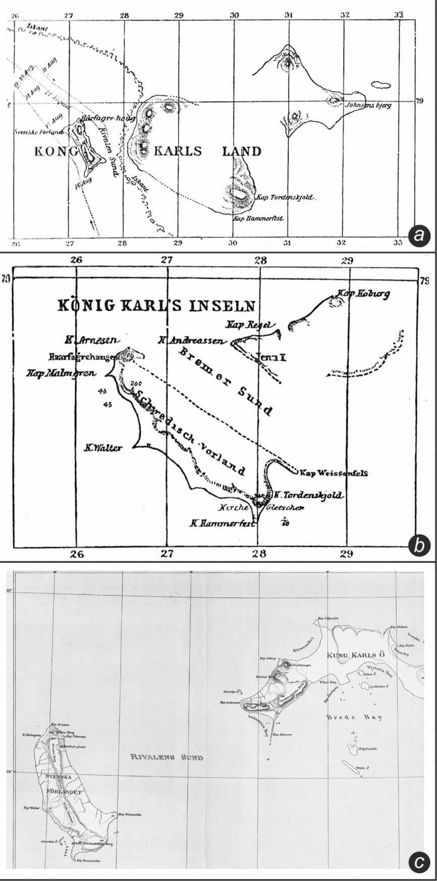
In August 1889, the sealing ketch Rivalen, captained by Henning Andresen, arrived at Kong Karls Land. Andresen discovered a sound between Svenskøya and Kongsøya which he named Rivalensundet, after his vessel. On 21 of August he sailed from north to south through the sound and sketched a chart. The following day he sailed back again from south to north and made more observations. When Rivalen returned to Tromsø, Andresen contacted Karl Pettersen at Tromsø Museum and handed over his notes, sketches and the ship's log. Pettersen subsequently published an article with a chart of Rivalensundet in the journal Ymer (Pettersen Reference Pettersen1889; Fig. 6).
Kong Karls Land: (a) Henning Andresen's chart of Rivalensund (Nathorst Reference Nathorst1900). (b) Kükenthal's chart of the same area (Nathorst Reference Nathorst1900). (c) Nathorst's own map of Rivalensund, the passage between Svenskøya (left) and Kongsøya (right), from 1898. From Feddersen and Nissen's archive (Courtesy of Wenche Nissen, Oslo).

Pettersen's chart was criticised by Willy Kükenthal in an article published by Petermans Geographische Mitteilungen the following year (Kükenthal Reference Kükenthal1890a). Kükenthal, a German Arctic explorer from Jena, had carried out a scientific programme at Svalbard from 1886 to 1888. The following year (1889) he returned to Tromsø with Walter Thymens of Bremen and chartered the sealing sloop Berntine captained by Nils Johnsen. They sailed to Svalbard but in the middle of June the Berntine was wrecked at Heleysund (Anna 1889). The two Germans were picked by the ketch Cecilie Malene, captained by Magnus Arnesen, and the expedition continued to Kong Karls Land where Kükenthal and Thymens made sketches for a chart (Kükenthal Reference Kükenthal1890b). They returned to Tromsø on 6 September 1889. Their observations formed the basis of their criticism of the Andresen/Pettersen chart. Unfortunately, Pettersen died from typhoid fever in January 1890 and could not therefore defend his work. Mr. Arnold Pike and Sir Savile Crossly had visited Kong Karls Land 1897 (Pike Reference Pike1898) and in the absence of contrary evidence, and after consulting Pike (Nathorst Reference Nathorst1900: 227), Kükenthal's map was sanctioned and published by British cartographers in 1898 (Arctic Ocean and Greenland Sea).
This story has a curious epilogue. When Kong Karls Land was charted by Alfred Nathorst in 1898 it transpired that the Andresen/Pettersen chart was almost correct while Kühenthal's was very inaccurate (Nathorst Reference Nathorst1900: 221). When it became known that Karl Pettersen had died, Kükenthal donated a considerable sum of money to Tromsø Museum.
Why did sealing masters engage in Arctic research?
The driving force behind the sealing masters’ service of science was rarely scientific enquiry. It was principally self-interest combined with curiosity. For instance, when Johannes Nilsen discovered Ormsundet (present day Heleysundet) in 1858 he kept it secret to avoid competition from other sealing masters (Kjær Reference Kjær2011). On the other hand when 40 years later, in 1898, he and Ludvig Sebelonsen, the master of the sealer Lykkens Prøve, found and unknown island of no obvious importance to them, they ignored it and, on meeting the British vessel Victoria with a Norwegian crew captained by P.W. Nilssen the following day, gave away its position. Captain Nilssen found it and named it Victoria Island after the ship.
In like manner, Franz Joseph Land had been visited by Norwegian sealers (in particular, Leonard Norem from Sanerøya in Trondheimsfjord (Sæther Reference Sæther1929)) before the archipelago was found by the Austro-Hungarian expedition. In 1865 and 1867 the sealing masters Nils F. Rønbeck and Johan P. Aidijärvi went sealing there. They called the archipelago Øst-Spitsbergen (East-Spitsbergen) but kept it secret to avoid competition (Feddersen and Nissen 1928, Sæther Reference Sæther1929).
Johnsen, Altman and Nilsen probably had no scientific ambition when they made the sketches that formed the basis of the first chart of Kong Karls Land. They had found a new sealing ground and, lacking any chart, they made their own. Being uneducated, they turned their material over to trained people who saw to it that a proper map was made and published. It is a credit to all concerned that Henrik Mohn both recognised the value of the masters’ work and gave them credit by putting their names on the new chart.
Edvard H. Johannesen, perhaps exceptionally, had a keen interest in science. Nordenskiöld saw the potential in the young sealing master and encouraged him to continue to make observations which he duly did and for which he received substantial recognition.
It was neither wholly for self-interest that sealing masters engaged in data collection nor wholly by chance that they were engaged by various scientific institutions in the 1860s and 1870s. Polar exploration was, and is, expensive. The first Norwegian northern oceanographic expedition was not a polar expedition but an expedition around the North Sea (1874–1878). This expedition was led by Henrik Mohn and G. O. Sars. When addressing the Norwegian Government for a financial contribution, the former stated that ‘Unexplored Polar areas will not be our task. They are something we must leave to wealthy nations’. Mohn knew the cost of polar exploration and he also knew that the NMI had saved money and achieved excellent results by engaging sealing masters to carry out field work on its behalf. In 1868 Nordenskiöld, likewise, asked ship-owner Johan Adrian Johannesen if his masters could collect plants and rocks on their sealing voyages according to the instructions drawn up by the University of Stockholm. He was rewarded the following year with a wealth of material (Ebeltoft Reference Ebeltoft1869). Three years later, in 1871, the Department of Geology at the University of Christiana asked sealing master Fritz Mack to collect geological specimens on his sealing voyages which he did, packing them in boxes and making careful note of the exact latitude and longitude at which each sample had been collected (Mack Reference Mack1873).
Men like Adolf Nordenskiöld, Adolph Ebeltoft, Henrik Mohn and Karl Pettersen exploited the knowledge, skill and, often, the daring of sealing masters to everyone's best advantage. These four, in particular, formed a highly productive Arctic science network. Ebeltoft was one of Nordenskiöld closest friends. He became godfather to Nordenskiöld's children and Nordenskiöld was best man at Ebeltoft's wedding in 1864. Nordenskiöld, in turn, developed his plans in co-operation with Ebeltoft whose task was to find suitable expedition ships, modify them to Nordenskiöld's specifications, select crews and act as intermediary for correspondence between Nordenskiöld and the sealing masters (Ebeltoft Reference Ebeltoft1864–1881). Both men recognised the potential and took advantage of the sealing masters’ skill and knowledge of the Arctic.
Karl Pettersen was a close friend of Henrik Mohn and worked closely with Nordenskiöld. Pettersen and Mohn had studied together at University. He invariably closed his letters to Nordenskiöld with the same sentence: ‘Do not forget our museum!’ Ebeltoft died in 1881 and Pettersen in 1890 and the concept of ‘Sealers in the service of science’ died with them. As a sealer wrote to Nordenskiöld: ‘After Karl Pettersen passed away I have no-one to turn to.’ (Norberg Reference Norberg1900).
Acknowledgments
I would like to thank Ivar Stokkeland (Norwegian Polar Institute), Trygve Nissen and Vigdis Rath (Tromsø) and Wenche Nissen (Oslo) for information and other support during preparation of this paper. I am grateful to an anonymous referee for helpful comments on an earlier version of this paper. Special thanks to Nicholas Tyler, UiT The Arctic University of Norway.