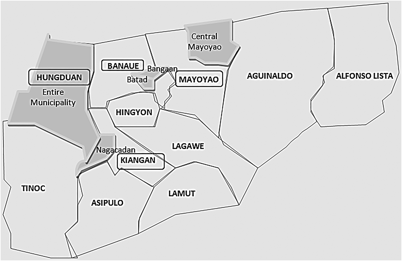

Despite the centuries-old practice of terraced wet-rice agriculture throughout Ifugao province in the Philippines, only five specific terraced landscapes, and their villages, were designated as part of a UNESCO World Heritage Site in 1995, as the ‘Rice Terraces of the Philippine Cordillera’.Footnote 1 The site is spread across four administrative districts (municipalities) and include the following inscribed ‘heritage clusters’: Batad (1,240 ha) and Bangaan (116.70 ha) in the municipality of Banaue; the entire municipality of Hungduan (22,789 ha); Nagacadan (818 ha) in the municipality of Kiangan; and Mayoyao Central (2,597 ha) in the municipality of Mayoyao.Footnote 2 The zoning of the heritage clusters categorises the landscape of the four municipalities into bounded core and buffer zones (see fig. 1). Core zones consist of the actual villages in a heritage cluster, and are subject to tighter conservation management guidelines and development restrictions. Buffer zones are adjacent areas that allow for commercial and residential activities, but must continue to support the conservation efforts in the protected core zones. While the Ifugao have three major ethnolinguistic groups, Ayangan, Kalanguya and Tuwali, this article concerns the Tuwali Ifugao. In particular, Tuwali is the major language spoken in the municipalities of Kiangan and Hungduan, the communities featured in this study.Footnote 3
Inscribed heritage clusters

Conservation dilemmas have emerged from the schism between the Ifugao visualisation of rice fields based on a concept of ‘good’ and the heritage agencies’ concern with the visual experience of the rice terraces. While acknowledging the principle of stewardship in conservation, the Ifugao fear that such activities may compromise present and future improvements to their livelihoods.Footnote 4 Judith Okely's distinction between ‘seeing’ and ‘looking’ is useful here for analysing these contrasting visualisations of the terraces.Footnote 5 Thus the Ifugao ‘see’ (rather than ‘look’ at) their terraces, a form of perception that requires the whole body as the means ‘to understand and resonate with the world’,Footnote 6 whereby the frame of visualisation shapes expectations.Footnote 7
Ifugao visualisations of their rice terraces relate to expectations of the good harvests necessary for community well-being. It is not only the farmers who rely on these fields, but landowners who, although not directly involved in agriculture, also benefit from a bountiful harvest. A rice field embodies the potential for prosperity for the whole community, that is, the well-being of the field is tied to the well-being of all those who depend on these fields. On the other hand, heritage conservation bodies often emphasise the need to protect the visual integrity of a site. Hence, for the Ifugao, the expectations of the conservation organisations — UNESCO, the International Council on Monuments and Sites (ICOMOS), the International Union for Conservation of Nature (IUCN) and the UNESCO National Commission of the Philippines (UNACOM) — often represent potential restrictions to economic opportunities, social and physical mobility, and access to services.
These divergent views of the terraces emerged in the socio-spatial relations involved in mapping as part of the conservation efforts. This article describes Ifugao responses to the final Joint Reactive Monitoring Mission carried out by UNESCO, ICOMOS and UNACOM in 2011. The Mission's objectives required mapping the core and buffer zones of each heritage cluster. Maps do not simply provide a representation of space, but also serve to influence how spaces are transformed by the very exercise of being mapped. In the case of the Ifugao Rice Terraces, areas to be demarcated were measured and surveyed, thereby enabling other means of measurements (such as the percentage of abandoned terraces, eroded walls, and the impact of road widening).
In this way, heritage management in practice is both shaped by and shapes maps, which then translate into actual zoning practices. This process not only promotes a particular visualisation of the selected rice terraces as heritage clusters, but also facilitates certain views about the management of the terraces. In Thongchai Winichakul's analysis on the drawing up of Siam's boundaries by France, Britain and Siam in the late nineteenth and early twentieth centuries, the act of mapping was not merely a device for carrying out military and administrative objectives; rather, ‘mapping turned both operations into its mechanism to realise its projection, to concretise its “enunciation”’.Footnote 8 The delineation of heritage clusters and buffer zones in Ifugao province not only encapsulates a particular vision of the landscape, it is the very way such a vision is realised.
Yet, the categorisation and maintenance of demarcated heritage zones in fact stimulated community scrutiny of the heritage monitoring missions. Such appraisals were underpinned by local visualisations of the landscape and what constitutes a ‘good’ rice field, rather than a ‘beautiful’ one. The Ifugao's own zoning and land use practices, as well as their critique of conservation initiatives, highlight what Cristina Grasseni posits as ‘ways in which vision can be shared across a community as an enskilled sense’.Footnote 9 She elaborates that ‘to exercise skilled vision means to belong socially in communities and networks that share aesthetic sensibilities, principles of good practice, rituals of participation, processes of apprenticeship, ideological stances and political interests’.Footnote 10 It must be noted that the enskilled sense involved in heritage conservation sometimes creates a process of ‘generalization’ whereby ‘compatibility standardizes difference’.Footnote 11 Specifically, the delineation of core and buffer zones perpetuates an idealised notion of how certain villages should be developed or protected from development. Consequently, particularities such as local views on landscape aesthetics and diverse zoning practices are overlooked.
‘Good’ fields
American anthropologist Roy Barton, who resided among the Ifugao in the early twentieth century, offered a brief but striking observation about their ideas of beauty and the landscape:
Despite the fact that the Ifugao's habitat is one of surpassing beauty … the myths lack any reference to beauty of landscape or of natural objects … It is true that when an Ifugao stops to rest on his steep mountain trails he seems to choose a jutting point, open so far as possible on all sides, and giving a good view … But I am convinced that he gazes vacantly, that the scene arouses no emotion in him.Footnote 12
Indeed, the contrast between a local resident's nonchalance towards their landscape in contrast to a visitors’ perception can be expected, since such a landscape is normative to locals. In my own experience, Ifugaos assert that they do not perceive any beauty in their landscape; however, they nevertheless acted with appreciation for it, by way of stopping to survey the land. Locals have particular spots along a trail that they favour compared to other sections of the trail. Similarly, they will often express their frustration with or approval of how a rice field looks. Yet, they express such sentiments without any reference to beauty. This conundrum requires further inquiry into the cultural specificity of landscape perception and its implications.
Barton's observation implies and assumes that perception is tied to a culturally specific experience of aesthetics attached to the appreciation of beauty. Yet, the idea that beauty and aesthetics are linked is itself problematic. David Howes points out that aesthetics derives from aesthesis, which generally refers to sensation and perception and is not related to ‘beauty’ per se.Footnote 13 However, the word was appropriated by philosopher Alexander Baumgarten, giving the word its modern association as a ‘critique of taste’.Footnote 14 I do not suggest that monitoring missions operate via a perception of the Ifugao Rice Terraces as art, hence their preoccupation with the visual conservation of a heritage site. In fact, the very inscription of the Ifugao Rice Terraces in the World Heritage Site rested on its value as an agricultural system, and ecological issues are indeed often discussed in conservation reports. However, changes in the agro-ecosystem are not tied to the visual in the same way as changes to the built environment, since ecological changes are not as visually obvious when viewing the expansive landscape. Yet for the indigenous rice cultivators, problems in the agricultural system are very much visually registered. The issue is not that there are varying definitions of what is being seen. Rather, at the crux of tensions between different evaluations of the state of the Ifugao Rice Terraces are conflicting forms of visualisations, that is, varying ways that the landscape is experienced in relation to expectations.
Though the Ifugao display an indifference to the terraces’ beauty, they still allude to views when expressing disapproval over the state of the terraces, but with a different focus from that of conservation organisations and not at all defined by beauty. The emphasis is on the state of the crops in the rice fields, and not simply on the built environment of terrace walls and houses. Ifugao views are dominated by knowledgeable observations about the terraced agro-ecosystem and the transformation of rice from seed into mature, robust panicles ready to harvest to become the valued foodstuff that contributes to well-being, or the reverse. The crop's progress from seeds to harvest likewise encapsulates local knowledge and investment in the entire community's future well-being.
When walking along dykes, a companion would frequently point out threats to the crop such as destructive snails in the paddies, the yellowing of panicles due to a crop disease or crumbly-textured terrace walls caused by water seepage. Even their appreciation for the view referred to the agricultural system. On hikes, some would stop to appreciate the scenery, and using borrowed English, Ilocano or Tagalog terms, would comment on the landscape's ‘beauty’. However, this epithet was always tied to comments on the workings of the agricultural system and the crops, rather than a quality of being beautiful to look at. Appreciation is conveyed with descriptions of the moment that crops reach synchronised maturity, the turning of the panicles from green to gold, which signal their readiness for harvest.
Eric Hirsch reminds us that the common expectation for rural landscapes to be picturesque arises from the ‘painterly origin of the landscape concept’, and that ‘landscape was recognized as such because it reminded the viewer of a painted landscape, often of European origin’.Footnote 15 Once, while looking at the Hapao Terraces, a Kiangan ecotourism coordinator mentioned the rather apocryphal anecdote of the disappointed tourist who came all the way to see the Ifugao ‘landscape’ while the terraces were being irrigated and proclaimed, ‘I spent all this money and all I got to see was mud.’ After a humorous retelling of this often-recited anecdote, he commented that even when all the rice fields are flooded and muddy, one should still appreciate that stage of the agricultural cycle. As he noted, there would be no rice crop without the first necessary step of muddy fields.
In her study of apple farmers in Normandy, Okely recalls how community members talked about their experience of seeing the orchards at apple blossom time. Like the Ifugao rice farmers, the apple farmers, whose life and work revolved around the orchards, located themselves in time and place through these visual experiences; it was through the act of seeing that they experienced their labour and the transformation of ‘the viewed place’.Footnote 16
In the Ifugao lands, the spatial link between rice and people is reflected in the way elders recall seeing destroyed rice fields soon after the end of the Second World War in 1945. As many elders relate, kin and fellow village victims of war were doubly mourned because people not only had to cope with the death of their loved ones, they also mourned the loss of productive crops and fields that families and village alike had invested in. Under Ifugao principles, the ownership of rice fields is transient, and their possession more akin to stewardship. In this way, the land is safeguarded for future generations, and present possession is trivial compared to how long the land has been in a family. The post-war reconstruction of the Ifugao lands required simultaneously burying the dead as well as repairing the fields for rice cultivation, actions which implicated family members across generations. Indeed, local landscape perception is tied to people's recognition of their fellow family and community members’ labour and investments towards maintaining their rice fields.
During a stay in Hungduan, I accompanied my host mother to a wedding in a nearby hamlet. On our walk to the hamlet, my host mother kept pointing out particular rice fields, saying, ‘What a shame’, or ‘That's not good’, and sometimes, ‘Now this is good.’ She was referring to the state of the crops, not the scenery, of course. She indicated that some of the rice panicles were scraggy and shorter than others, signalling a bad harvest to come, while others were more robust, signalling a better harvest. In some instances, she determined the state of the panicles from a distance, and then as we reached the particular field would show me in detail what she was referring to. While the Ifugao do not recognise their landscape as being beautiful or make any reference to its visual marvels, they do however very much visually register destructive changes in the fields.
The rice crops within the terraces are more likely to be described as maphod (good) or adi maphod (not good), instead of ‘beautiful’. Actually, maphod is used not simply to describe an object itself, but as a compliment to the person whose skill is manifested in the object. However, when my host mother pointed out that a field was adi maphod, she was not criticising a particular farmer's technique. Instead, she was highlighting the perennial burdens of the rice farmer. I admitted that when I looked at the fields all I could see was a wide expanse of green; they all looked the same. She indicated her understanding, as if she expected my inability to notice such agricultural nuances.
In Maurice Bloch's analysis of the concept of clarity in Zafimaniry's socio-spatial relations, he notes that:
by understanding the central value of clarity and what lies behind the enthusiasm for viewing panoramas which display clarity … we can share Zafimaniry ethical and aesthetical concepts about the landscape as well as understanding their equanimity towards the geographical changes occurring around them …Footnote 17
As Bloch explains, the topography of Zafimaniry country in Madagascar, which is wooded and mountainous, is often ‘shrouded in mists, rain and clouds’.Footnote 18 There, landscape is perceived as a manifestation of God, and can ‘affect people in ways beyond explanation’.Footnote 19 Through making lasting marks on their environment, humans can transcend their fragility and become part of the immortal, enduring landscape. The hardening materiality of wooden houses, the erecting of stone mortuary monuments, and the clearing of forests and cultivating of rice fields are all marks on the landscape that are emblematic of pleasant living conditions, since such human activities arise in clarity and can be seen from having clear views.
Bloch's analysis provides another useful approach to understanding what underpins the act of viewing. In Ifugao province, a window to grasping both people's frustrations and appreciation of their environment lies in the aforementioned concept of maphod, which is used as an index of quality and value, as opposed to a notion of beauty. As previously mentioned, in using ‘beautiful’ as a description, the Ifugao often borrow English, Ilocano or Tagalog terms. The most common borrowed word for beautiful is napintas,Footnote 20 an Ilocano term without an equivalent in Tuwali. People often asserted that ‘beautiful’ or ‘beauty’ was an external concept. Locals often expressed their frustration over the conservation and tourism bodies’ preoccupation with the beauty of the terraces. While the word maphod can describe something that may be aesthetically valued, Ifugao informants affirmed that the word is not associated with aesthetics per se.
The fact that something is maphod and napintas is circumstantial and not automatic, since maphod and napintas are not interchangeable, nor complementary. As previously indicated, Barton also notes the lack of the word ‘beautiful’ in Tuwali in his early ethnographic accounts of the Ifugao. He traces the origins of the borrowed word napintas to the Spanish word pintado (painted), a word that is associated with the quality of being picturesque. However, the root word pinta in napintas can also be interpreted as deriving from the Spanish word pinta which relates to the look of a person or thing, but does not connote beauty.
While looking at drums at a trade fair in Kiangan, for instance, I spotted a drum with an intricately carved wooden base, which I showed to my Kiangan host-mother's friend. When I asked her if the drum was maphod, she proceeded to tap the drum and upon hearing its dull sound confirmed that the drum was adi maphod. She began tapping other drums, evaluating the quality of sound each emitted. She drew my attention to how the unadorned drums with superior acoustics were more expensive than the ornate but dull-sounding drums. The drums were after all valued for their sound, not for their carved wooden bases. Maphod is more associated with the quality, of something or someone coming into their potential. Quality, however, cannot just be detected with sight. It is instead experiential.
My host mother often commented on the change in the quality of the traditional Ifugao tapis (skirt), noting that the contemporary textiles have a very course texture. I asked if the texture mattered if the skirts were visually identical, she replied, ‘Yes, because they won't feel the same.’
As we have seen, such multisensory judgements are extended to rice. The robustness of panicles, the tallness of stalks, and the way in which stalks barely touch each other on the field, are especially noticeable to community members, even non-farmers. As Okely notes with the agricultural communities of Normandy, what one can see in a landscape is what one can also, ‘savour as taste, smell, and feel with hand and mouth’.Footnote 21 The sensory aspect of rice is expressed by the quality of its grains; good rice, particularly tinawon — a native rice variety planted only once a year — is appreciated for the fluffiness and size of its cooked grains, as well as its aroma, and the feeling of satisfaction that eating it gives. Tinawon rice is regarded by the Ifugao as more filling than the newer high-yielding varieties.
Visuals and visualisations
Several weeks into my residence in Kiangan, community members working in the civil and non-profit sectors began to buzz about an impending monitoring mission from representatives of conservation organisations. The visit marked the final year of the Joint Reactive Monitoring Missions undertaken regularly since the designation of the Ifugao Rice Terraces as an endangered World Heritage Site in 2001. A member of the mayor's staff admitted that most of the community were not that concerned or even aware of their rice terraces being on a World Heritage List, much less as endangered sites. In fact, as she acknowledged, only those whose work entailed engaging with conservation organisations were heavily involved in the activities surrounding heritage conservation.
After its placement on UNESCO's list of endangered World Heritage Sites, a Master Plan for the maintenance of the Ifugao Rice Terraces had been drafted, an outcome that resulted from initial stakeholder workshops conducted in Ifugao province.Footnote 22 The Plan was established through discussions amongst international and national heritage organisations — UNESCO and the National Commission for Culture and Arts, respectively — along with the national, provincial and local governments, and community members, especially the farmers. A consultant and architect from Kiangan who worked on several conservation initiatives described the drafting of the Master Plan as a truly collaborative endeavour. She recalled:
When I joined the first stakeholders’ workshop I was overwhelmed by the presence of farmers and international consultants, and I saw how they had conducted the consultations, and at that time, it really was a dialogue.
She pointed out that the conservation organisations had since deviated from the collaborative nature of that initial meeting and these meetings had become less dialogical, and that certain representatives from the conservation organisations were more collaborative than others. Based on aspects of the Master Plan, international conservation organisations such as UNESCO and ICOMOS created their own benchmarks on what to expect in the maintenance of the Ifugao Rice Terraces. During the Joint Reactive Monitoring Missions, representatives from UNESCO, ICOMOS and UNACOM evaluated each of the heritage clusters.
Such monitoring visits were intended to evaluate the progress in the heritage management efforts and determine if the Ifugao Rice Terraces were to: remain classified as an ‘endangered’ site, be removed from the endangered list and retain their status as a World Heritage Site, or to altogether lose this designation. In each of the heritage clusters, the representatives, whom I will hereafter refer to as ‘the monitoring team’, were treated to activities such as hikes and cultural performances. Each visit included a consultation forum between the monitoring team and community members and a final, provincial-wide forum held at the Banaue Hotel.
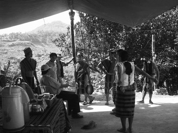
In 2011, prior to visiting the heritage cluster of Nagacadan, Kiangan, the monitoring team visited heritage clusters in Mayoyao and Hungduan. I was a volunteer then with the Save the Ifugao Terraces Movement (SitMO), a local NGO. SitMO played a role in organising the welcome programme for the monitoring team's visit to Nagacadan, Kiangan's heritage cluster. As a volunteer, I was asked to assist in the preparation of scheduled activities. As such, we organised two consecutive day hikes across the heritage clusters of Nagacadan. On the first day, we carried food and other supplies to the venue, and coordinated plans for the following day's intermission performances with a farmers’ association (fig. 2). On the second day, the monitoring visit to Nagacadan took place.
Bayninan Farmers’ Association members practising prior to the Joint Reactive Monitoring Mission’s visit

The community consultation followed lunch and intermission performances, presented by members of the Bayninan Farmers’ Association, in which they performed a celebratory dance and a hudhud (epic narrative chant). Though ‘community consultation’ implies a dialogue, which suggests treating residents as advisers, the ensuing discussion did not unfold as such. The monitoring team conveyed what they had observed during their visits and communicated their concerns, which was then followed by a question-and-answer session. However, alternative views were neither elicited nor discussed. As the forum progressed, it became rather clear who was taking on the position of consultants, and which views were being propagated and expected to be enacted. The final consultation held later at Banaue Hotel echoed the tone and structure of the Nagacadan forum.
Another doctoral researcher, an Ifugao from Hungduan, recalled the monitoring team's vocal opposition to the construction of cable cars across rice fields during one of the meetings. Although UNESCO was amenable to the construction of suspension cables for the purpose of moving goods, they were concerned about their use for public transport. While UNESCO cited safety concerns, another prominent reason offered for their opposition was uneasiness over how such a mode of transportation would impact the panoramic view of the terraces. The researcher from Hungduan recalled that one community member responded to conservation concerns over the suspended cable car by commenting that people could use Photoshop to digitally remove the cables from their photographs.
This comment was one of many examples of the facetious tone in which people responded to comments made by representatives of the heritage bodies. During the final provincial consultation at Banaue Hotel, a member of the monitoring team commented that the rooftops of the houses within the terraces were painted in jarring colours that did not seamlessly blend in with the landscape. An audience member responded by muttering, ‘Should we use green then, or maybe brown?’ Yet the monitoring team had alternative reasons for its recommendations regarding the construction of houses and infrastructure, including pressing ecological and safety concerns. Soil stability, erosion, waste management and the contamination of natural resources were among the litany of issues cited by conservation organisations. However, such reasonable considerations were lost in the dominant concern for preserving a ‘beautiful’ visual experience of the landscape.
In the report which documented the final forum, the monitoring team's preoccupation with the visual is all the more glaring:
mini-hydro power plants should be permitted as long as they are mini-hydro plants and positioned, as much as possible in natural depressions and/or places with minimal visual impact …
An added challenge is the use of visually jarring colors on roofs covered with G.I. sheets, especially within the terraces. Not surprisingly, such houses are frequently visually intrusive in the landscape …
Recent tourism-related facilities are increasingly posing a major problem – visual intrusion, questionable land use and extension of facilities onto communal property …Footnote 23
The monitoring team's frequent references to visual impact served to reduce their broader agro-ecological concerns to the preservation of ‘pleasant’ or ‘picturesque’ views of Ifugao province's terraced landscape. Community members perceive conservation organisations as being concerned primarily with aesthetic issues. Those who live in the heritage clusters often assert that the terraces were not created with views and beauty in mind or that they are not concerned with the appearance of the terraces in their own right. A community member who was previously a key staff of the Governor's Office once proclaimed,
One thing they (UNESCO) don't understand is that we don't care about the aesthetics, it just so happens that the terraces are beautiful, just by chance. But to us, what's beautiful is something that's useful.
Once again, the fissure between maphod and ‘beautiful’ was at the crux of the division over how the Ifugao Rice Terraces are viewed and what people expect from the fields. As community members expressed, the fact that the agro-ecosystem of the rice field translates into something very visual, and deemed beautiful, is circumstantial. In this case, a good field is a beautiful field, but it is valued for being good, not for being beautiful; for what good is a beautiful field which produces a bad harvest. What qualifies as ‘good’, in relation to productive yields, is how the well-being of the field is indelibly linked to the well-being of those who tend them.
In September 2011, a forum was held at Banaue Hotel to host engineers from the Philippines’ National Mapping and Resource Information Authority (NAMRIA), the agency assigned to map the Ifugao Rice Terraces’ core and buffer zones. The forum was in response to one of the conditions that emerged from the Joint Reactive Monitoring Mission. As UNESCO and the ICOMOS stipulated in their report, the provincial government of Ifugao had to map out the core and buffer zones of the Rice Terraces:
The process for mapping will entail: (1) Boundaries will be determined through the consensus of all parties … (2) Boundaries falling within private property will need the consent of the owner … (3) Boundary lines based on satellite imagery will be verified through groundwork; (4) After mapping the boundaries using GIS, LGUs [local government units] will be asked to confirm them; (5) … ordinances will be passed at all levels of government to ensure the maps become legal documents and the baselines for CBLUZPs [community-based land use and zoning plans]; and (6) CBLUZPs will be developed through community participation.Footnote 24
The mapping of the core and buffer zones was seen by some as a necessary and long overdue task.
As explained by the director of the Ifugao Cultural Heritage Office, a department within the Office of the Provincial Governor:
Six years after we were inscribed, because of our non-compliance with some requirements, we were listed in the endangered list. They gave us at least 10 years to submit all the requirements … Unfortunately until 2011, nothing was done, nothing happened regarding these pending requirements. When we reviewed all the benchmarks and requirements we have to meet one of them is the mapping of these heritage sites.
Indeed, the Master Plan identified three major projects: a ‘bio-physical’ component, which entailed a community-based land use map, a physical planning and zoning programme for the management of resources, and the regulation of development activities.Footnote 25
During the NAMRIA forum, audience members from each municipality included in the heritage site were asked to discuss the parameters of their buffer zones. While the forum was open to the public, the fact that it was held at the Banaue Hotel revealed its limitations. The views presented in the forum, particularly on zoning, were limited to participants who had the resources to travel to and attend the meeting. Unlike the municipal forums held at each heritage village, the provincial forum at Banaue Hotel was predominantly attended by local political leaders, civil servants, elders, researchers and NGO personnel.
Since the core zones had been predetermined as heritage clusters, the deliberation primarily regarded which villages should be included in the buffer zones. Representatives from each municipality formed a huddle around the conference room to discuss their buffer zone. Following the discussion, community members presented their maps, elaborating on the rationale for their selected buffer zones. Since the entire municipality of Hungduan is a core zone, those from Hungduan reasoned that their buffer zone must include neighbouring municipalities such as Banaue, Hingyon, Kiangan and Tinoc, as well as the neighbouring province, Mountain Province. The governor had to intervene, noting that since Mountain Province was another province, it was outside his jurisdiction and he therefore could not influence development activities there.
The issue of boundaries is a potent one in Ifugao province because it invokes indigenous ancestral domain boundaries, which are not always in agreement with national administrative ones. According to the Indigenous Peoples’ Rights Act of 1997, Ifugaos can uphold their customary laws over national laws in regards to the settling of conflict. Thus, boundary disputes regarding ancestral lands are not settled in court with legal proceedings, but are often mediated by the National Commission of Indigenous Peoples. Yet, these contestations are part-and-parcel of how resources are renegotiated and reaffirmed.Footnote 26
Even the parameters of the heritage clusters came into question during the forum. Some audience members began to comment on the inconsistency of the sites, referring of course to the expanse of the sites covered in Hungduan and Mayoyao, or the fact that although Julongan in Kiangan is also considered a core zone, it is somehow not named in official reports, which cite only Nagacadan as a heritage cluster. Confusion and criticism over the scope of heritage clusters are commonplace in Ifugao province. Rice farmers who are aware of heritage activities, but who reside in non-heritage cluster areas, often question why they are not included in the site, despite practising terraced, wet-rice cultivation. For this reason, the governor had to remind the audience at the forum in Banaue that the exercise of mapping the terraces was not to nominate new sites or expand existing ones, but a way to manage already inscribed sites.
The expansion of heritage boundaries, although rare, is permissible. In 2009, the parameters of the Tubbataha Reefs Natural Park, another UNESCO World Heritage Site in the the Philippines, were increased.Footnote 27 In fact, the comparison between the Tubbataha Reefs National Park and the Ifugao Rice Terraces is visually captured in Philippine currency. An illustration of the Ifugao Rice Terraces was featured on the 1,000-peso note, the largest note in the Philippines, issued between 1985 and 2010. However, when the currency was amended in 2010, Tubbataha Reefs Natural Park replaced the Ifugao Rice Terraces on the 1,000-peso note. On the other hand, the image of the Ifugao Rice Terraces was placed on the 20-peso note. A community member pointed this out to me, humorously noting that they had been ‘demoted’. The choice is a rather strategic one, because tourists are more likely to possess 1,000-peso notes, which now feature the state's current ideal of a world heritage site.
While representations of the Ifugao Rice Terraces in tourist paraphernalia and the national currency reveal perceptions about tourist destinations, the issue of boundaries is particularly telling in terms of how the Philippine highlands are visualised. The heritage clusters are more commonly known as the Ifugao Rice Terraces to Ifugaos and communities in the Cordillera Region; however, to many Filipinos outside the Cordillera, the clusters are referred to as the Banaue Rice Terraces. On the other hand, UNESCO's official name for the World Heritage Site is the Rice Terraces of the Philippine Cordilleras. Such labels do not take into account Cordillera history. Independent and sometimes conflicting settlements were subsumed and classified into commandancias — regional civil governments during the Spanish colonial period (1565–1898) — a categorisation which although revised, was extended during the American colonial period (1898–1946). During Spain's colonisation of the Philippines, the village of Nagacadan, one of the heritage cluster sites in Kiangan, actually saw itself as separate, often in opposition to other Kiangan villages at lower elevations. Thus, the zoning of core and buffer zones neglects the nuances of the Cordillera region. In imagining a pan-Cordillera custom of the practice of terraced agriculture, rice terraces are perceived to be a Cordillera-wide phenomenon. However, the heritage site designation is not extended to other areas of the region; in fact, it is bounded only within the borders of Ifugao Province.
In documenting the implementation of a buffer zone for the Chief Roi Mata's Domain, a World Heritage Site in Vanuatu, Adam Trau, Chris Ballard and Meredith Wilson critically examine how the theory and praxis of zoning within the context of heritage conservation is locally contextualised, resulting in contestations and ambiguities. As they suggest, the buffering of resources is a common practice beyond the context of heritage conservation. However, the principles that presently underpin the concept of buffer zones in heritage conservation were the product of a move towards linking conservation with economic development.Footnote 28 This ushered in community-based initiatives from resource management, conservation and development.
At the crux of the implementation of the buffer zones is the understanding ‘that conservation and development are mutually interdependent’.Footnote 29 Trau et al. underscore that tensions regarding these buffer zones should not be simplified as an opposition between global versus united local conceptualisations of buffer zones. They argue instead, that at the heart of such contestations regarding zoning is that the ‘heterogeneity of local or Indigenous communities and the multiplicity of their ideas and interests sit uneasily within global imaginings of community-based heritage preservation’.Footnote 30 In Ifugao province, boundary issues along with diverse indigenous land-use practices all come into the foreground in tensions arising from the mapping of areas into core and buffer zones.
During the NAMRIA forum, representatives from Kiangan came prepared with a previously completed community-based land use map. The map emerged from a SitMO initiative, which was funded by a grant from the Philippines League of Corporate Foundations. Interlocutors in Nagacadan remarked that their community-based map and the resulting ordinance render a local practice to fit within national and transnational contexts. In this way, the act of mapping became a way to institutionalise land use practices, but reciprocally, local practices informed the community-based map that was utilised for the drafting of the ordinance. The creation of the ordinance demonstrates not just how external contexts are adopted, but rather how they undergo a process of ‘endogenisation’.Footnote 31 This process refers to the culturally specific ways in which people adopt and engage with external contexts. The ordinance, which was a result of workshops and consultations with Nagacadan community members, outlines regulations for tourism and development, as well as demarcates core, buffer and multi-use zones.Footnote 32
Land use planning and zoning is not novel to the Ifugao, and in fact, their management of natural resources and the agro-ecosystem of rice-cultivation depend on indigenous Ifugao zoning practices. The act of rendering their practices in two-dimensional form through maps and ordinances became a means to engage with central authorities, and external institutions and organisations. Marc Brightman points out in his account of conservation efforts in Suriname that the Trio people's active role in conservation and development, which may involve adopting external methods of mapping, monitoring, data collection and policing, should not be seen as a threat to Trio cosmology and practices.Footnote 33
While Nagacadan garnered the praise of the monitoring mission, other heritage clusters challenged assumptions that zoning practices are homogenous throughout Ifugao province. In Francis Lambrecht's description of Ifugao villages in the 1920s, he too observed classifications of land and the way villages adapt to the topography, wherein the zoning is arranged in relation to altitude, consisting of a village with upper, middle and lower parts.Footnote 34 However, the classification of land is not consistent throughout the municipalities, especially amongst the various ethnolinguistic groups. These inconsistencies in land-use classifications are implicated in the mapping of core and buffer zones. In many Ifugao villages, houses are near but not within rice terraces; however, as Lambrecht pointed out, the topography of Mayoyao necessitated the building of houses within terraces:
The valley of Mayawyaw [sic] is a very broad one surrounded by steep mountains on which very few houses can be constructed, unless very distant declivities be selected. But this latter step would take the people away from their rice fields. Hence, the natives put their houses in the middle of their fields.Footnote 35
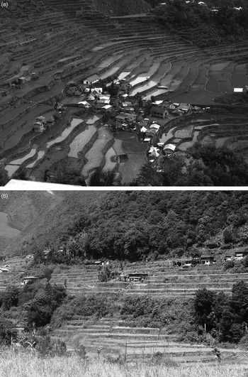
The building of houses within the terraces has been queried by conservation organisations, who particularly question the size of the houses (figs. 3a, 3b), often implying that this is a new practice, rather than a long-standing one. Furthermore, settlement structures are not solely determined by topography or location, but are in fact tied to Ifugao tenets regarding allowable land use and related activities. As the Mayoyao case demonstrates, cultural variances in the organisation of settlements within the designated World Heritage Site must be acknowledged properly by conservation bodies.
(a) Clusters of houses in Batad, Banaue (top) and (b) Scattered houses in Hungduan terraces (bottom)

While the monitoring mission challenged the house settlements, it encouraged the inclusion and promotion of churches as part of Ifugao heritage, particularly those in Kiangan and Hungduan. Ironically, the churches are newer than the dispersed houses. Yet the Monitoring Mission forum at Banaue Hotel, suggested that particular churches, even those within the rice terrace clusters, as in Hungduan, should be highlighted in tourist paraphernalia, particularly in maps. The monitoring mission argued that the churches are an integral aspect of the historical engagements between Ifugaos and missionaries.
This is ironic because the churches are indeed indices of the cultural transformations that have impacted the Ifugao's agricultural techniques. In Barton's own early account, he observed the weakening correspondence between the execution of rituals and the agricultural system. Years before the Green Revolution, Barton documented that Ifugaos were already cultivating two crops a year, with farmers supplementing the tinawon rice with a second cropping of rice.Footnote 36 Barton lamented that this dual-cropping system was affecting the undertaking of Ifugao rituals. Such agricultural techniques were promoted by Spanish missionaries in the nineteenth century. In particular, due to its location and varied topography, communities at lower elevations of Kiangan became the ‘center for crop introductions and innovations, which subsequently spread throughout Ifugao’.Footnote 37
Father Juan Villaverde, a Spanish missionary, was particularly concerned with introducing more productive and intensive agriculture. To Villaverde, the annual-cropping rice variety did not seem sufficient and he encouraged locals to plant a second crop on their rice fields after the harvest. In Barton's later critique of changes in Ifugao agricultural techniques, a second cropping made ‘agricultural rites crowded together more closely than before’.Footnote 38 While the second crop sometimes yielded a larger harvest, the new system concomitantly lowered the standard of rice cultivation.Footnote 39 Such transformations were initiated by Catholic missions that promoted the abandonment of Ifugao rice cultivating rituals. Conservation organisations, in fact, often tie the abandonment of earlier agricultural techniques, and related rituals, to the weakening ecological soundness of farming practices and the eventual deterioration of the terraces.Footnote 40
While Hungduan was encouraged to highlight its churches, conservation organisations often criticise the establishment of small-scale hydropower equipment in the municipality. The Hungduan cluster exposes how the inconsistencies in heritage zoning implicate community development projects. Although the entire municipality is considered a heritage cluster, certain areas are more distinctive than others due to their contiguous terraced fields, and similarly because they lie along common routes through the mountains. It is these more reachable and visible areas that are heavily scrutinised. Referring to the construction of mini-hydropower plants in more isolated parts of Hungduan, one resident jested, ‘Bring all the buildings in the mountain areas, and what, have all the UNESCO people walk up the mountain? They won't be doing that, that's why look, they didn't see the other micro-hydros.’
The implication is that infrastructural projects are subject to scrutiny not simply due to a concern for environmental impact. Such projects are tied to a particular visual experience of the Hungduan landscape. This particular visual experience is rooted in what falls within the zoning and monitoring of the heritage cluster. Thus, areas along Hungduan's primary road are more regulated, since these areas are also more easily accessible and visible. Ironically, the roads that allow areas to be reachable, often a cause for concern, are the very means that allow heritage representatives to map and monitor heritage areas more efficiently.
Raymond Bryant demonstrates how conservation initiatives are ‘simultaneously moral observations and agendas’, and that, ‘there are various social and political implications that follow from the moralized basis of conservation’.Footnote 41 Bryant compares two approaches to conservation in the Philippines. One approach is the Integrated Protected Areas System (IPAS), the state's official conservation strategy focusing primarily on protecting biodiversity hot spots. An alternative strategy is the protection of indigenous communities’ ancestral domain claims promoted by the National Commission on Indigenous Peoples.
As Bryant highlights:
While IPAS emphasizes biogeographical criteria in border delineation, the ancestral initiative uses bio-cultural criteria reflecting local socionatural histories. The point here is not whether the borders are the same or not. Rather, it is to recognize that differing assumptions, logics and methodologies are involved in territorial marking.Footnote 42
Interestingly, the enactment of conservation principles shapes the delineation of spaces in ways that reciprocally inform the implementation of conservation initiatives in these protected zones.
There is an obvious disparity in what constitutes a core zone in Kiangan and Hungduan. The entire municipality of Hungduan is a heritage cluster, while only one village in Kiangan is officially recognised. Kiangan predominantly consists of buffer zones, where regulated construction and commercial development can occur with less scrutiny. Meanwhile, because the entire municipality of Hungduan is a core zone, this limits the municipality's liberty to sequester areas to be developed beyond residential purposes or for agriculture. Currently, the Free and Prior Informed Consent procedure requires communities to be consulted in projects that are related to and impact indigenous knowledge systems and practices. This process, which is undertaken by the National Commission of Indigenous Peoples, was established as part of the 1997 Indigenous People's Rights Act; however, the Ifugao Rice Terraces was inscribed as a UNESCO World Heritage Site in 1995, before informed consent procedures were established.
The challenge in Ifugao province is precisely that certain principles were being legitimised with policies that are pervasive. Such principles are in fact guided by literal views, more specifically, what can be seen and not seen from viewing points and pathways along the more famous rice terrace clusters of Hungduan. In this way, ‘the seeing of something is invariably the making of a choice of what in our visual field must be backgrounded so that something can be perceived in the foreground’.Footnote 43 These views become potent particularly during conservation organisations’ monitoring visits. Once admonitions are established against particular activities within the terraces, organisations are less likely to fund projects that might be contested not only by members of the local communities, but also members of transnational organisations.
Conclusion
Throughout the early phase of mapping the core and buffer zones of the Ifugao Rice Terraces World Heritage Site, the consultations and workshops greatly involved community members who often worked alongside and guided engineers along the terrain. Community members provided their own advice based on their knowledge of the community and the landscape. However, the final mapping of terrains was divorced from the earlier stages of drafting of the map. After coordinates were acquired, surveyors returned to Manila in order to draw up the maps, whilst communicating their progress with the provincial government. It was not until months later, and through an official announcement, that the Ifugao public were informed of the finished map to be presented to the governor at a ceremony at the Banaue Hotel in February 2012.
During the ceremony, the Ifugao provincial government was presented with large full-colour copies of NAMRIA's map. According to the statements of Virginia A. Miralao, Secretary General of UNACOM, and former governor Eugene Balitang, the maps are described as guidelines for future development projects, wherein certain restrictions will be followed. Projects to be regulated include, ‘the building of medium to high-rise structures, putting up of cellular phone sites, public transportation routes, and even the construction of farm-to-market roads’.Footnote 44 In August 2014, the Department of Public Works and Highways (DPWH) suspended road-widening projects in the municipalities of Kiangan, Banaue and Hungduan due to the reported damage caused to the terraces.Footnote 45
The maps presented to the community during the ceremony were eventually kept by the provincial government, in the same manner that the Master Plan is also stored in the Ifugao Cultural Heritage Office in the Provincial Capitol.Footnote 46 The maps and the Master Plan do not feature in the everyday lives of Ifugaos, nor are many Ifugaos even aware of these documents. However, such documents are readily available for the public, a point I return to later. Yet these maps, along with the Master Plan, embody the dynamic engagements between diverse human actors. Likewise, the very process of mapping and viewing rendered in paper form, are the point of reference and means which engender such engagements. For starters, it is in their paper form that such maps can be ceremonially recognised and presented to political leaders or circulated during forums. To view the physical maps requires a visit to the Ifugao Provincial Capitol or the mayor's office of the respective municipality. Electronic versions of these maps do exist, but their PDF versions do not engender the same relations.
Several months after the mapping mission and weeks after I left Ifugao province, the Ifugao Rice Terraces was officially removed from the endangered list, while maintaining its heritage status. As stated by UNESCO:
On 31 January 2012, the State Party submitted a report on the state of conservation of the property, providing details on the progress attained to achieve the Desired state of conservation for the removal of the property from the List of World Heritage in Danger (Decision 34 COM 7A.26) through implementing the corrective measures, while also responding to the recommendations of the March 2011 and previous reactive monitoring missions.Footnote 47
Among the corrective measures indicated as having been satisfied is the matter of community-based maps, in which:
In the framework of the Retrospective Inventory the cartographic documentation, delineating the property and its buffer zone has been prepared in close collaboration with all stakeholders and submitted to the World Heritage Centre … The World Heritage Centre and the Advisory Bodies consider that the necessary steps have been taken to develop the community-based land-use and zoning plans, although this requirement has not been fully achieved.Footnote 48
Far from being just visual representations of core and buffer zones, maps embody the very processes of the creation and maintenance of these zones, along with the messy relations entangled in conservation and development activities. While such maps also visualise expectations for the future, they do so in ways that overlook local aspirations.
In her own study on the conversion of rice fields into bean gardens in Asipulo, Ifugao, Dierdre McKay suggests that such transformations are people's aspirations materially grounded. Bean gardens signal and actualise people's opportunity to sell beans in markets, which in turn indicate the possibility for tenants to potentially buy rice fields in the future, thereby gaining a chance to elevate their status. Likewise, they allow for the possibility of sending relatives to work overseas, which again relates to visions of prosperity. As McKay explains, ‘the crops that are planted in Ifugao fields say volumes about how the people planting them envision themselves in relation to both the state and to global labour markets.’Footnote 49 The state of the rice terraces and their transformations can be seen in the nuances that are often pointed out by Ifugaos, or the socio-spatial relations McKay highlights. Such nuances are more likely to go unnoticed by the very people who value the terraces for being beautiful.
When I was still residing in Kiangan, I attended a tourism forum held on the grounds of the Ifugao Museum. The forum featured discussions on how a community-based map could factor in the measuring of Nagacadan's carrying capacity for tourists.Footnote 50 On a larger scale, in terms of the development projects for the province as a whole, the core-and-buffer-zone map may be useful for giving consideration to its agricultural heritage. The mapping and monitoring of heritage clusters not only constitute, but also affect how heritage management is enacted, and the culturally specific, nuanced engagements that emerge in and from them. Nevertheless, it should be recalled that the actual established core and buffer zones, along with their representation on a map, are heterogenous and arose out of tensions and negotiations.
In his ethnography on an Amazonian community's relationship within and with their environment, Peter Gow analyses an official text regarding the communities of Bajo Urubamba, Peru. The Comunidad Nativa de Santa Clara is a land title which comprises of both map and text.Footnote 51 The map cannot be used for orientation purposes. Instead, as Gow explains, the saliency of the map lies in the fact that it has become ‘a physical reference point’ in land disputes between the communities of Santa Clara and their neighbours.Footnote 52 The map, which is held by the Ministry of Agriculture in Lima, ‘is the direct physical embodiment of someone else. This someone else, unknown to the people of Santa Clara … is the one who embodied the laws of the Peruvian State’.Footnote 53 As a representation of a space and certain principles regarding claims and access to that particular space, the title has the capacity to be the very way in which said principles are enacted. ‘We imagine such pieces of paper to embody abstract principles … but they can only do so because they are pieces of paper.’Footnote 54
I do not know how the drafted core-and-buffer-zone maps of the Cordilleras Heritage Site will be utilised, especially at a moment when, no longer listed as endangered sites, the preoccupation with conservation could lessen. Though, as previously mentioned, already a road widening project has been scrutinised and restricted. Such events show that, rather than stabilising conditions, maps can become avenues for destabilisation. All the while, in the very ambiguities that maps generate, they are likewise required, implicated and transformed. Significantly, these maps also have the potential to encapsulate and enliven tourism, agriculture and housing in Ifugao province. These activities are constituted in the adaptation of terrace management practices and the deliberations over them.
Community members continue to grapple with the social and environmental transformations occurring in their region and how to adapt in ways that take into consideration Ifugao across generations. Integral to how such issues are reflected upon is how community members situate external frameworks within the context of their own local concepts. This is especially manifested in the Ifugao's concept of ‘good’ in relation to their criticisms on the association of ‘beauty’ with the rice terraces. I have presented such local configurations on the value and maintenance of the rice terraces not simply to emphasise other ways of seeing, but to show how ways of seeing are situated, challenged and politicised. It is thus necessary to shift away from a preoccupation with critiquing ocularcentrism, and instead, address how being ‘trained in one way of seeing rather than another’ impacts subjectivities, ideologies and social relations.Footnote 55 It is this focus on vision and the practice of seeing that shows the difference between ‘beautiful’ terraces and ‘good’ rice fields, and the constitution of these differing views on the present living conditions and future aspirations of Ifugao communities.