

Namaqualand is an anomaly in South Africa because of its distinct cultural, social and environmental conditions. However, the marginalization and poverty experienced by the people of the mission stations and reserves in Namaqualand during the nineteenth and twentieth centuries display a generic profile that they share with the communal enclaves, labour reserves, and former homelands across South Africa. Today, Namaqualand is at the forefront of the implementation of land reform, communal tenure reform and the management of municipal commonage (Rohde et al. 2002, 2003; Wisborg and Rohde Reference Hoffman, Dean, Allsopp, Allsopp, Palmer, Milton, Kirkman, Kerley, Hurt and Brown2003, 2004; Lebert Reference Lebert2004; Lebert and Rohde Reference Hoffman and Rohde2007). These developments take place against a history of land policies that progressively enclosed both communal and private farm land, resulting in the overcrowding and impoverishment of communal areas. This article traces the environmental history over the last 100 years or so of one village in a communal area of Namaqualand, showing how environmental change took place against a background of repressive or inappropriate government policies, in conjunction with fluctuating macro-economic conditions, intermittent drought events and the agency of communal farmers themselves. It details the impact of this history on the environment and biota of the village commons in relation to a number of different land-use practices that have changed substantially over time.
Covering 50,000 square kilometres, Namaqualand is sparsely populated by about 66,000 people, 45 per cent of whom live in the six communal areas scattered throughout the district. Covering just 25 per cent of the area of Namaqualand, the communal areas are home to the descendants of the Nama-speaking Khoekhoen, the first herders in the region, who arrived here with their sheep around 2,000 years ago (Webley Reference Webley1992). Contact between Nama-speaking herders and San hunter-gatherers, and later with runaway slaves and white settlers, resulted in Namaqualand's contemporary ‘coloured’ Afrikaans-speaking population.
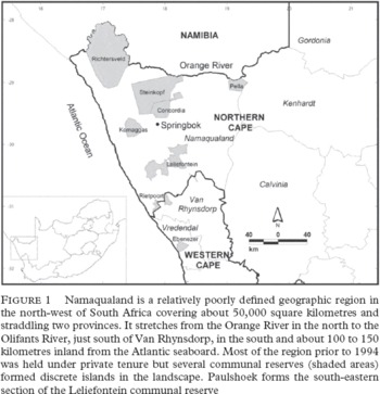
The widely dispersed Coloured Communal Areas are important social and administrative features of this landscape. They began as mission stations, places of refuge from the increasingly violent, marginalizing effects of frontier colonialism. Later they became labour reserves for commercial farming and mining interests and today, although overcrowded and poor, they provide a limited safety net against the uncertainties of contemporary life. Leliefontein is one such area, comprising ten widely dispersed villages: Paulshoek is one of these villages, surrounded by 20,000 hectares of communal grazing land.
In order to set the pattern of environmental change around Paulshoek within a regional context and to give structure to what otherwise might seem a progression of arbitrary events, we have borrowed the idea of ‘ecological revolutions’ (Merchant Reference Merchant, Miller and Rohtman1997: 19). These are defined as ‘major transformations in human relations with non-human nature’ that arise due to changes in the relationship between society's mode of production and its ecology as well as between society's mode of production and reproduction.
We hypothesize that three distinct ecological revolutions occurred in Namaqualand during the last two millennia (Hoffman and Rohde Reference Hoffman and Rohde2007):
1 The pastoral ecological revolution, which took place as a result of the introduction of domestic livestock and pastoral societies into the area approximately 2,000 years ago;
2 The colonial ecological revolution, which spread first through pathogens, making way for the first white trekboers who moved into the area during the mid-eighteenth century. Over the next 200 years, white colonists appropriated most of the land for commercial livestock farming and mining, confining the original inhabitants to increasingly small communal reserves and creating the apartheid of two distinct social, economic and ecological outcomes;
3 The post-agrarian ecological revolution during the last forty years or so. Evidence of this can be discerned in the overall decline in livestock numbers, a substantial reduction in crop land and the decline in the rural population associated with rapid urbanization. This phase includes the transformation of the South African social economy after 1994, the end of agricultural subsidies to white farmers, the expansion of the communal land base through land reform, and an upsurge of conservation activities associated with tourism such as the creation and expansion of the Namaqua National Park.
We have argued elsewhere (Hoffman and Rohde Reference Hoffman and Rohde2007) that these ecological revolutions can be clearly identified in Namaqualand's landscapes. The evidence we present here is concerned with the transformation that has accompanied the end of the colonial period and the post-agrarian ecological revolution. This process can be conceptualized in terms of distinct phases or ‘acts’ within the colonial ‘eco-drama’ (Weiskel Reference Weiskel1987; Rajan Reference Rajan, Dovers, Edgecombe and Guest2002). The history of Paulshoek takes place in the last act of the colonial eco-drama and is made up of a number of ‘scenes’ in which the dynamics of exploitation, dependency and marginalization within the colonial ecosystem are played out.
The social economy of Paulshoek has evolved from a subsistence way of life dependent on livestock and cropping within the narrow confines of the communal area of the Leliefontein Reserve in the first half of the twentieth century to one reliant on the regional and national economy by way of formal and informal jobs, remittances and (increasingly) state welfare during the second half. This process has been accompanied by the establishment of centralized service villages and a minimal level or ‘safety net’ of state support. The ‘scenes’ which encapsulate this process can be set within the following time frames or ‘acts’:
1900–39 – peasant farmers and dispersed outstations;
1940–65 – villagization and gradual transition from subsistence agricultural economy to wage and state welfare dependence;
1966–93 – formal employment within parastatal industries and mining, the policy of economic units and retrenchment;
1994–2005 – political, agrarian and economic transformation.
Each of these acts of social, economic and broad political change was accompanied by environmental impacts that can be traced clearly within the landscape today.
The landscape is a manifestation of the dialectical relationship between human interactions and nature, in which practices, decisions and ideas are given physical form that in turn influences human behaviour. To a greater or lesser extent, landscapes are adapted to the socio-cultural and political systems that have coexisted with them (Balee and Erickson Reference Balee and Erickson2006). This is not to say that landscape and livelihood change are in a direct ‘driver-feedback’ relationship, since human agency is subject to the shifting relations of power and knowledge that form the context and outcomes of human–environmental relationships (McCusker and Carr Reference McCusker and Carr2006). Preceding publications concerned with the political ecology of landscape change in Africa are too numerous to discuss here (examples include Crosby Reference Crosby1986; Tiffen et al. 1994; Beinart and Coates Reference Beinart and Coates1995; Leach and Mearns Reference Leach and Mearns1996; Fairhead and Leach Reference Fairhead and Leach1996; Grove Reference Grove1997; McCann Reference McCann1999; Dahlberg and Blaikie Reference Dahlberg and Blaikie1999; Showers Reference Showers2005) and we should point out that our main intention is to combine socio-economic and political history with biological evidence within an historical ecology framework.
This article has purposely avoided engaging directly with a number of debates concerning issues of rural transformation in Namaqualand and South Africa today. Such debates address questions of land management, conservation objectives, poverty reduction, land reform and democratization. Often these debates revolve around conflicts of interest and political values and world views – and they are often couched in the ‘objective’ language of scientific discourse. The evidence we have presented here might contribute to these debates but our main objective has been to link the historical narrative of Paulshoek with the methods of environmental science in order to show, in some detail, just how and why this particular landscape has evolved during the twentieth century.
A PROFILE OF PAULSHOEK TODAY
The majority of Paulshoek's 120 households (approximately 600 residents) rank among South Africa's rural poor. A survey conducted in 1995 (Rohde et al. 2003) found that the average per capita income was R215 per month, which is below all standard measures of poverty based on income (DBSA 1998; Eckert Reference Eckert, Lipton, de Klerk and Lipton1996; Carter and May 1998) and in international terms is roughly equivalent to a per capita income of less than $2 per day.Footnote 1 Forty-two per cent of Paulshoek's population aged between 15 and 65 are economically inactive and 38 per cent are unemployed – leaving only 20 per cent in employment (Stats SA Reference Debeaudoin2001). Only a third of school leavers between the ages of 15 and 35 are employed, with an average monthly wage of R754 (Rohde and Hoffman Reference May and Lahiff2005).Footnote 2 Wages and remittances earned by Paulshoek's migrant labourers form 51 per cent of village income; state support in the form of pensions, disability allowance and child support provides an underlying safety net for almost a third of village households. Only 20 per cent of village income is accounted for by locally generated self-employment, casual labour and farming, although this is probably an underestimation of the real value of local income when the full suite of natural resource utilization is taken into account (Rohde et al. 2003).
While livestock and crop farming are a minor factor in the cash economy of the village (4 per cent), these activities provide a critical supplement to an otherwise limited diet and a latent ‘capital’ surplus to be drawn on in times of need. In spite of the low economic value of agricultural outputs, many aspects of Paulshoek's cultural and social economy remain rooted in historical land-use practices, the most obvious being the maintenance of strong links between the village and stockposts. Approximately 8 per cent of total village income is derived from the surrounding environment when estimates of the use values of natural resources are added to income from crops and livestock (ibid.).
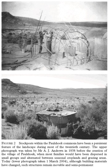
Stockposts are usually situated close to water sources consisting of natural springs, shallow dug wells or boreholes. Some consist of a permanent dwelling adjacent to rain-fed croplands. They tend to be occupied by single men or, rarely, a husband and wife. Due to the spatially and seasonally unpredictable rains, transhumance across the Paulshoek landscape is an integral part of the pastoral system but reasons for moving are complex and include a range of environmental and socio-economic factors (Baker and Hoffman Reference Baker and Hoffman2006). The relatively small number of stock farmers (approximately 30) tends to obscure the fact that nearly half of Paulshoek's households own livestock.
Wide inter-annual variations in rainfall and the frequent occurrence of droughts coupled with high stocking densities mean that stock farming is a highly uncertain enterprise, but it remains one of the only livelihood opportunities in the village. Many different people engage in farming at various times of their lives as part of a suite of risk reduction and livelihood strategies. The fact that this resource is open to any villager who has the means to acquire animals means that it often acts as a social and economic link for migrant labourers, both while they are away working and when they wish to come back to live in Paulshoek (Debeaudoin Reference Debeaudoin2001; Modiselle Reference Modiselle2001; Anseeuw and Laurent Reference Anseeuw and Laurent2007).
PAULSHOEK'S SOCIAL AND POLITICAL HISTORY
Pastoral and colonial background to the creation of Paulshoek
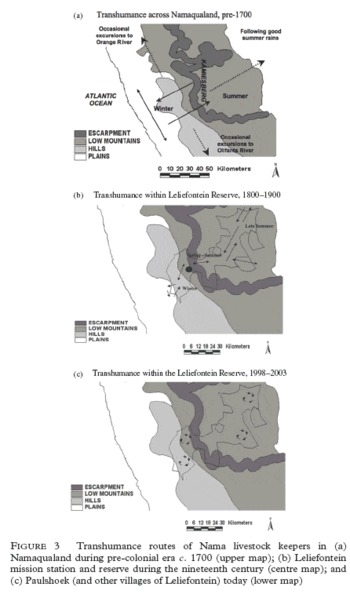
Up until the late nineteenth century, grazing practices were migratory within the ambit of Leliefontein's three distinct agro-ecological zones: the sandveld near the coast, the Kamiesberg escarpment and the summer rainfall grasslands of Bushmanland to the east (Webley Reference Webley, Hall and Smith1986, 2007). Although seasonal transhumance continued throughout the nineteenth century, it became increasingly restricted and less adaptable to seasonal climatic changes. By 1850 the Leliefontein mission lands were divided into a number of outstations (one of which was near the present-day village of Paulshoek), and discrete internal divisions within the area demarcated winter and summer grazing lands (Figure 3).
The fortunes of Leliefontein inhabitants rapidly declined in the wake of recurrent extreme drought events during the 1880s and 1890s, causing crop failure, loss of livestock and destitution (Marais Reference Marais1968; Price Reference Price1976; Rohde et al. 2003). The effects of drought were compounded by legislation which attempted to control and reform communal institutions: the imposition of a house tax in 1878, the attempted privatization of communal lands in 1890, and the establishment of government control over the mission stations in 1913 are examples. Gradually, sedentarization occurred as a result of the alienation of large tracts of private land allocated to white farmers surrounding the mission and increasing population pressure within. By this time parts of the landscape had already been transformed by the daily concentration of large herds around a limited number of water points. The frontier was closing quickly and the final act in the colonial ecological revolution was in progress.
Scene 1: peasant farmers and dispersed outstations – 1900–39
The elderly men and women of Paulshoek agree that the origins of the village began with an exodus from the old mission station of Leliefontein in the early years of the twentieth century and increasingly from the late 1920s as the grazing land around the mission became overcrowded. Paulshoek was at that time an outstation, used during the months preceding the breeding season when rams needed to be kept separate from the rest of the herd. These rams were herded communally, under the guardianship of an old man named Paul Joseph. The name followed naturally: ‘And every time the people asked “where can I put my ram” the people said “send him to Paul's corner” [Paul se Hoek]. So the place became Paulshoek' (Interview with Ouma Betjie, 23 June 1999).
Dirk Dirkse, a relation of Paul, built the first stone house in the vicinity of Paulshoek around the turn of the century. He was one of the ‘pioneer’ communal farmers – the first to settle the area on a more or less permanent basis – having herds of cattle and using oxen to plough the first fields. These pioneer communal farmers had much in common, economically and agriculturally, with their counterparts among the white farmers who settled on land adjacent to the Leliefontein Reserve at this time. During the first decades of the twentieth century this scattered sedentary population gradually cleared more land to plant wheat, oats, barley and rye as it was divided up amongst succeeding generations by the children of the original pioneer farmers (on privately-owned farms as well as in communal areas), who continued to keep cattle, sheep and goats.
The economic depression of 1929–33 occurred during an extended period of exceptionally poor rains between 1923 and 1938, resulting in impoverishment and the disruption of peasant production in the reserve. One elderly woman recalls the desperate circumstances of her childhood:
The people were poor, very poor. I remember a boy who had no clothes, not even a jacket or pants or nothing. His mother walked around in rags. So my mother gave her some of our clothes, and she at least made him something from that. (Interview with Ouma [Grandma] Betjie, 23 June 1999)
Because reserve borders were unfenced and still permeable at the time, communal farmers were able to migrate and exploit grazing on adjacent state or commercial land. They also began to settle the more marginal parts of the reserve and during this period many families moved to Paulshoek. Some came from outside the reserve while others were from Leliefontein village because it was becoming too crowded:
In the early days there were very few of us and the land was open on all sides: we could graze on what is now commercial land to the south, east and west of us. At that time there was no need to migrate to the onderveld or anywhere else because there was enough space in this area. (Interview with Oom [Uncle] Karel Joseph, 14 March 2000)
To an extent, this corner of Leliefontein represented the last fragment of a rapidly closing frontier and as such was a faint reflection of the early colonial settler way of life.
While population pressures internal to the reserve continued, the creation of individual title for white farmers in Bushmanland during the 1930s is one example of how external events affected Paulshoek. Not only were the emergency grazing areas of Bushmanland alienated from communal farmers, but coloured farmers and farm workers, known as Basters,Footnote 3 who had settled in the area during the late nineteenth and early twentieth centuries, were forced to resettle within already crowded reserve areas. One group of such exiles moved to Moedverloer, a few kilometres to the east of Paulshoek, in an area that had been only sparsely and sporadically inhabited as an outstation. Such communal grazing land still contained a significant cover of palatable shrubs (such as Eriocephalus microphyllous, Hirpicium alienatum and Ruschia robusta). Radical environmental change coincided with the immigration of eight Bosluis Baster families who had been evicted from white farms in Bushmanland in 1938, along with over 2,000 sheep, goats and donkeys. This number of animals almost doubled during the 1940s before the Basters finally moved to the Richtersveld in the early 1950s (personal communication, Oom Karel Joseph, Paulshoek village elder, 14 March 2000). By this time, Moedverloer had been transformed from a veld ‘rough and overgrown’ with palatable perennials to an area capable of sustaining only small herds of livestock during reasonably good rainfall years.
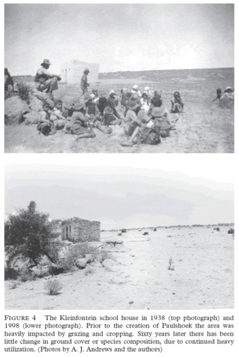
In 1932 in Kleinfontein, a long narrow valley to the west of the present village of Paulshoek, Jacobus (Ouboetetjie) Joseph constructed a small stone house, which was subsequently used by the community as a church and then also as a school. Between 55 and 60 children attended classes (see Figure 4).
In 1937 there was such a terrible drought here. We were so hungry when we went to school … . And if we came across a rabbit that jumped out in front of us then we wouldn't go to school for the day. We would rather spend the day catching that rabbit. We didn't have matches. We would use a stick, which we would rub against a stone. Then the stick would get so hot and we would put it into some donkey dung and hold it up to the sunlight and then it would burn. Then it would start smoking and then we would make a fire. Then we would braai [cook] the rabbit and eat it up. It wouldn't matter if we got to school that day – we would rather get a hiding: we could never resist a rabbit. (Interview with Oom Samuel van der Westhuizen, 14 March 2000)
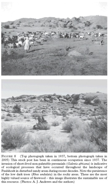
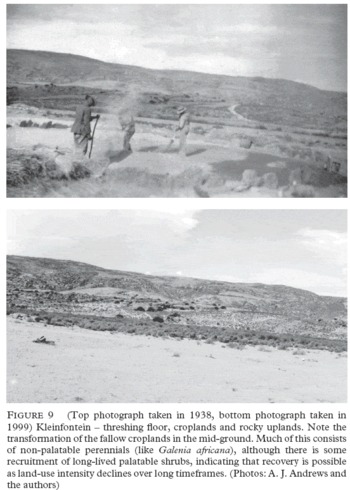
This scene in one of the last acts of the colonial ecological revolution was played out in much the same way as it had been in other reserves throughout Namaqualand. Early peasant settlers began a process of agrarian transformation of the landscape that was to escalate over the coming decades. Croplands that were ploughed in deep sandy bottomlands at this time show little sign of recovery, and stock posts that were first inhabited on a seasonal basis have become permanently settled. While there is no doubt that by the early twentieth century the peasant population of Leliefontein and Paulshoek was integrated in the regional economy, many communal farmers retained the ability to earn a substantial part of their income from agriculture. At the end of this first scene, we have photographic evidence that the landscape was indeed transformed, at least in the main settlement areas (figures 2, 4, 8, 9).
Scene 2: The growth of Paulshoek, closing borders and wage dependency – 1940–65
We were living far apart, and just temporarily in our places. And that was in 1940 to 1945. We stayed in [stock posts] such as Jan Cloete se Puts, Perdedam, T'oeroegorras, Windpoort, Pan se Plaat and Gooikloof, Golmuskie, Moedverloer. And then we moved to Paulshoek in 1946. We lived in all those places, but we all came to this little church in Kleinfontein. (Interview with Oom Samuel van der Westhuizen, 14 March 2000 – see Figure 4)
During the decades following the depression, livestock numbers returned to late-nineteenth-century levels and the reserve's human population increased by a third (Cape Archives 1891, 1904, 1909; Carstens Reference Carstens1966). This came about as a result of government policies that simultaneously consolidated white settler farming on reserve borders and promoted territorial segregation with the migrant labour system. At the same time, the Union government was busy finding ways of linking segregationist policies to ecological recovery. De-stocking schemes and the introduction of the camp system to communal areas were promoted after the 1936 Drought Commission and in 1939 became a cornerstone of Betterment planning (Beinart Reference Beinart1984). This was taken up later with renewed vigour by the Tomlinson Commission of 1956 in the context of the Bantu Authorities Act (1951) in order to combat soil erosion and promote agricultural expansion within viable Bantustans. Formal rules governing rights of residence and access to grazing were instituted in the Namaqualand reserves along with various taxes on livestock, arable and residential land. The Boards of Management and Advisory Boards that were set up to administer the reserves' internal affairs were in effect institutions designed to ensure that the economic development of these areas was in line with the interests of the state and the labour requirements of commercial farmers and mining companies.
Up until 1940 many whites were little better off than the reserve inhabitants, both groups having suffered during the prolonged depression (Sharp and West Reference Sharp1984). However, the colour divide steadily deepened as legislation such as the Land Settlement Act of 1940 provided grazing licences, eventually converted to ownership rights, to white farmers. In 1948, grazing regulations to be administered by the Reserve Management Board were passed, which set limits on stock numbers and stock post movements (Government Notice 2600).
Meanwhile, reserve families began to gravitate to the newly established Paulshoek village in 1942 in order to be closer to the school and church and because of new regulations relating to summer and winter grazing. During the winter, families and their livestock were concentrated around Paulshoek in kraals built just outside the village boundary. ‘Now we stood in a line and we left our croplands till the summer time, after the harvest, then we would move back’ (Oom Karel Joseph 14 March 2000). A linesman was employed to enforce the exclusion of livestock from the village and to make sure that cropping areas were reserved for summer grazing and the lowlands for winter grazing. This system seemed to work for about 20 years, but a major change in the practice of seasonal transhumance occurred in the 1960s, coinciding with a period of extended drought (1964–73), increased labour migration and changing lifestyles in the younger generation. The effects of this ‘line’ are evident in the landscape surrounding Paulshoek, which today has few palatable shrubs as a result of the heavy grazing associated with the concentration of kraals located here during this period.
In 1950 almost 10 per cent of Leliefontein's population consisted of whites (some of whom had immigrated from as far afield as Cornwall and St Helena) and mixed marriages were common (Leeuwenburg Reference Leeuwenburg, Whisson and van der Merve1972; Sharp Reference Sharp1984). All this would change with the introduction in 1950 of the Group Areas Act which confined ‘coloured’ farmers to the reserve areas, denying them access to non-privatized, state land across the reserve borders (Archer and Meer Reference Archer and Meer1998). Not only did the Group Areas Act result in a dramatic increase in the reserve population as a result of forced removals from other parts of the country, but, with the provision of pensions, many retiring coloured farm workers ‘returned’ to the reserves, often with their families and livestock.
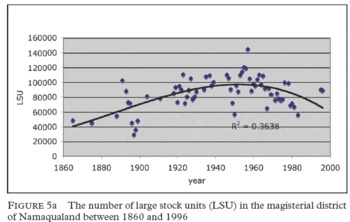
This expansion of the reserve population within a limited land base was exacerbated by the agricultural policies that encouraged neighbouring white farmers to fence their land, sink boreholes and initiate a paddock system with rotational grazing practices. This had a substantial impact on the communal farmers since the porous borders became fixed, effectively enclosing the communal farmers into the commonage. This happened during the mid-1950s, at the peak of livestock numbers in Namaqualand (see Figure 5). Contrary to what Dean and MacDonald Reference Dean and MacDonald1994 have argued, evidence from Namaqualand suggests that the overall decline in livestock numbers was not a result of degradation, but rather a direct consequence of an agricultural policy that promoted de-stocking while the communal areas continued to carry increasing numbers of livestock (Rohde et al. 1999; Benjaminsen et al. 2006).Footnote 4 For the people living in Paulshoek, livestock movements, firewood collection and medicinal plant harvesting were thereafter restricted to the communal area.
Between 1950 and 1970 copper and diamond mining and the fishing industry flourished, producing low unemployment and a degree of prosperity (Sharp and West 1984). Employment opportunities gave both white and coloured Namaqualanders a chance to overcome the uncertainty attached to farming in a marginal environment with an unpredictable climate. Whites were able to invest capital in commercial farming by amalgamating private farms, while others moved off the land altogether. This depopulation of privately-owned farms made it possible for whites to increase the size of individual land holdings, making commercial livestock farming that much more viable. Many white commercial farmers bought second farms in the summer rainfall Bushmanland region to the west of Leliefontein, or in the succulent rich sandveld towards the coast, thereby increasing their management options and effectively reproducing pre-colonial transhumance herding patterns, a practice which continues today among many white farmers who move their stock between farms according to seasonal and climatic conditions.
The effect of this economic growth on local people who had in the meantime been classified as coloureds was somewhat different: newly erected fence lines coupled with the prohibition of coloured farming outside the reserve meant that, from the late 1950s onwards, communal pastoral mobility as a response to drought and seasonal grazing conditions was increasingly confined to discrete village grazing lands within the reserve (Figure 3; c). Such restrictions were mitigated somewhat by the fact that coloured people were not restricted by pass laws, nor were they forced back into the reserves from urban areas like many Africans (Hendricks Reference Hendricks1997). Permanent out-migration from the reserves to the urban centres of Namaqualand and further afield made it possible for remaining reserve inhabitants to crop and herd livestock from this limited resource base and for extended family networks of reciprocity to function between rural and urban areas in time of need (Sharp Reference Sharp1984). This freed the reserves from the levelling effects of progressive overcrowding leading to absolute poverty.
While many family members sought work away from the village, those resident in Paulshoek were largely engaged in agricultural production and over thirty extended families held rights to croplands, covering most if not all of the potential arable land. The clearing and cultivation of croplands reached its peak during the 1960s at a time when many young villagers still aspired to becoming smallholder farmers. Migrant labour had been a way of supplementing family incomes since the inception of the reserve system, but with increasing population pressure and drought during the 1960s, young men left the village to become migrant mine workers, or to join parastatals that controlled many industries, including the railway and telephone systems.
The number of households in Paulshoek increased by more than 70 per cent during the 1960s. The new village continued to attract families who had previously resided on stockposts in Paulshoek and Leliefontein as well as the families of agricultural labourers from the surrounding commercial farms (Leeuwenburg Reference Leeuwenburg, Whisson and van der Merve1972). At the same time as labour migration increased, villagers became truly sedentary as a result of the security provided by village life and remittances from absent family members.
Until this time, little material improvement was discernible from one generation to the next. Ouma Sara Maarman's story is one of long hours of hard work and deprivation as a female herder on the white-owned farms to the east of Paulshoek. Her daughter, Tannie [auntie] Hanna, spent her childhood under material circumstances just like hers, working as part of the family unit for a white commercial farmer. The story of the family's rise to better fortunes began when Tannie Hanna met and married Oom Damon. At first they worked together as herders, moving from farm to farm. In between these periods of paid employment they began to re-establish the family in the reserve:
In the sixties we came back, mainly for the children. They were able to go to school here, and my brother was living here already. We left the children here, but we had to go on working for the farmers. We still had to pay the levies. In 1973 we came to stay for good. For the first couple of years we were lessees, but eventually we became citizens and could work for ourselves. (Tannie Hanna Jas, 22 June 1999, quoted in Abrahams 1999: 18).
It was a time of rapid social change. Population expansion and the continued proletarianization of the reserve population spelt the decline of mixed farming as a viable livelihood option for all but a few. Many of Paulshoek's once extensive croplands have remained fallow since then. The separation of private and communal land with fences created an environmental division that has only widened with time. The fence line contrasts, which today are often cited as evidence of communal degradation, are also an indication of how the veld can recover under reduced grazing pressure. This period marks the real beginning of the divided landscape, in both socio-economic and ecological terms, that characterizes the divisions of Namaqualand today.
Scene 3: Formal employment, economic units and retrenchment – 1966–93
The 1960s were a pivotal point in the social economy of Paulshoek and mark the transition from a mixed-farming subsistence economy supplemented by migrant wage remittances to one that was almost wholly dependent on migrant labour and state pensions. By the end of the 1960s Paulshoek had about 70 households – approximately half of today's population. People who settled or returned to Paulshoek were no longer farmers or agricultural labourers drawn from the surrounding rural areas, but predominantly migrant labourers from mines, urban centres or the highly intensive grape and vegetable farms of Klawer and Vredendal to the south. Families increasingly sought the security of established rights to residence, where their children would have access to education. The aggregation of extended families provided a form of social security, not only for those in need, but also for those who had access to employment outside the village and required a family network to care for those who were left behind.
During the 1970s and 1980s, people settled in Paulshoek for very different reasons than they had previously. The amenities of the village, its safety and the ability of the unemployed to survive here on very little money, made it attractive to many members of extended families who had been absent, often for most of their lives. The village also grew as a result of redundancies and forced retirements from the regional mining sector and increasingly from the parastatal industries. Relatively high wages and retirement packages enabled many to build comfortable brick houses, a trend that continues into the present. Some of these returnees also invested capital in livestock, in many cases providing subsistence wages to local herders.
During the second half of the twentieth century most national agricultural policies were designed to promote the interests of (white) commercial farmers, using ecological models based on equilibrium and succession (Tainton Reference Tainton1999) as a justification for promoting the camp system, infrastructure grants, stock reduction schemes and drought relief programmes (Benjaminsen et al. 2006; Rohde et al. 2006). Such policies were predicated on the notion that extensive soil and vegetation degradation was occurring as a result of overgrazing. This formed the background and justification for the Rural Coloured Areas Law (Coloured Persons Representative Council) of 1979 which established the basis for privatizing much of the commons. It was decided to subdivide the Leliefontein reserve into ‘economic units’, in order to encourage entrepreneurship and the development of the region. It was thought that privatization would lead to more ‘developed’ farming techniques and better conservation of the area, and that these changes would rid the area of ‘whimsical’ and ‘irrational’ traditions that were retarding modernization (Boonzaier et al. 1990; Rohde et al. 2006).
Thirty of the 47 farming units established in 1984 for the Leliefontein Communal Area were rented to individuals or syndicate groups, while the remaining 17 units were reserved for communal use. The majority of people who were granted economic units had other sources of income – they were typically shop owners, teachers and mine workers (Archer et al. 1989). The majority in Leliefontein never accepted the ‘economic units’ initiative because it marginalized communal farmers even further than previously. Popular resistance against this scheme was widespread and it was successfully contested in 1988 when communal residents won their case in the Supreme Court on legal technicalities.
Traces of the economic unit policy are visible today in the rangelands of Paulshoek where fences, in various stages of disrepair, still demarcate camp boundaries. On the whole, this period is a faint mirror image of the ecological revolution of de-agrarianization which occurred throughout the region at this time (Hoffman and Rohde Reference Hoffman and Rohde2007). Communal and commercial croplands were abandoned and many, especially in more marginal areas, remain fallow today; the partial recovery and recruitment of perennial plants is often misinterpreted as evidence of overgrazing (Hoffman and Rohde Reference Hoffman and Rohde2007).
Epilogue: political and economic transformation – 1994–2007
The 1990s represent another watershed period for the village of Paulshoek. With the democratization of national politics and the creation of several development and land reform programmes, material improvements have occurred in the village. Many previous observers believed that the reserve's pattern of marginalization, poverty and social fracture were somehow inevitable (for example, Price Reference Price1976). It was suggested that the worst-case scenario of a ‘laissez-faire policy’ (which is basically what transpired during most of the twentieth century) would lead to an ‘increase in absolute poverty, growth of class distinctions, migration away from the area, deterioration of physical resources and decline in internally generated capital’ (Leeuwenburg Reference Leeuwenburg, Whisson and van der Merve1972: 26). It is true that these processes have occurred – poverty exists, as do class distinctions. There has also been no immediate improvement in the conservation of natural resources and there is little to suggest that outside capital has been put to productive use inside the communal area. The solution of land privatization or ‘group-based, industrial farming’ was unsuccessful. However, events since 1994 have shown how quickly the transformation of the rural social economy can occur. The addition of commonage through the Land Reform Programme (Rohde et al. 2002; May and Lahiff Reference May and Lahiff2007), new housing provided under the Reconstruction and Development Programme (RDP), the reorganization of local government, the inclusion of Paulshoek's younger generation in the political decision-making processes of the village – these and other recent developments would have been unthinkable only 20 years ago.
In spite of these positive changes, little has changed in terms of land use and its impact on the commons, which are typically portrayed by policy makers and agricultural advisers as examples of degradation caused by overgrazing and inappropriate land-use practices (Hoffman and Ashwell Reference Hoffman and Ashwell2001). Today, land redistribution within the Land Reform Programme is dependent on the formulation of management plans approved by the Department of Agriculture, along lines which are not dissimilar to those promoted under the ‘economic units’ policy. Commercial farms bordering the Leliefontein communal area are being bought by the Department of Land Affairs and made into Municipal commonage to be administered on a different basis from the old commons. Management plans for these new communal farms stipulate a low fixed carrying capacity, adherence to the camp system, a prohibition on donkeys and kraaling or the erection of shelters for herders, and a monthly payment per head of livestock (Rohde et al. 2002; Lebert Reference Lebert2004; Lebert and Rohde Reference Hoffman and Rohde2007). The imposition of a management system based on commercial farming models, as well as the relatively large distances that have to be travelled to access the new Municipal commonage, has meant that to date only wealthier farmers have benefited from these programmes.
Impacts of Land Use on the Environment
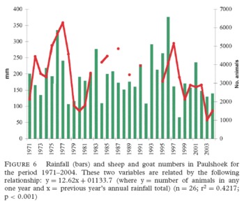
Land-use practices in Namaqualand have always been strongly influenced by the climate of the region, especially rainfall and temperature. These climatic influences are not static in either space or time but vary considerably across the landscape and over days, months and years. Paulshoek falls within the arid and semi-arid winter-rainfall Succulent Karoo biome and has a mean annual rainfall of 200 millimetres with high inter-annual variability (see Figure 6). This temporal variability is matched by a significant spatial difference in annual rainfall across the landscape, determined largely by distance from the Kamiesberg massif and by local topographic features. Livestock herders appreciate this spatial variability and sometimes move their stock posts to areas of better grazing where isolated thundershowers have fallen.
While rainfall is a key driver of ecosystem processes and human responses in the region, several different land-use practices, some of which have changed substantially in their extent and intensity over time, have influenced the composition and dynamics of Paulshoek's landscapes over the last 100 years. However, not all landscape units (such as rivers, sandy pediments, rocky uplands) have been affected in the same way or to the same extent, and neither have all land-use practices had the same degree of influence. Two distinct processes account for the obvious environmental differences observed across fence lines between communal areas and neighbouring privately-owned farms: the impact of decades of firewood collection and relatively high stocking densities on the communal side and the lower stocking levels within rotational systems of fenced camps on the other. The collection of medicinal plants (Goldberg Reference Goldberg1998) and reeds and other materials such as Polymita albiflora (Evans Reference Evans2001), used for constructing shelters, have had a relatively small and insignificant impact on the environment.
Before 2003, when electricity was installed in the village, households relied predominantly on fuelwood for their energy needs. Although 18 different species were commonly collected and used for a range of different purposes (such as cooking, heating, baking, ironing) Rhus undulata, a 2–3 metre evergreen shrub, was preferred and used extensively by all households (Solomon Reference Solomon2000). Using a time series analysis of aerial photographs which start in 1960, Solomon 2000 has shown that, despite decades of use, this species has not declined in abundance in the region even at localities close to the village. Its ability to survive drought and to re-sprout after being harvested (even when all of its above-ground stems were experimentally removed at ground level) has ensured its survival. However, the impact over many years of the removal of the dead material from a number of small (less than one metre) shrubs which dominate the region has perhaps been more significant. In an assessment of the impact of fuelwood harvesting on rangeland succession, Solomon 2000 experimentally removed dead shrub skeletons and measured the response of seedlings growing underneath. She recorded a 17 per cent increase overall in shrub mortality when dead material was removed. Such impacts on the differential recruitment of key rangelands species could have significantly influenced the composition and biomass production of Paulshoek's environments over the long term. With the installation of electricity, total fuelwood consumption has declined by 75 per cent, although many poorer households continue to collect and burn fuelwood to augment their energy needs (Price Reference Price2005).
For the first half of the twentieth century cultivation was widely practised on the sandy pediments by all households in Paulshoek. This formed part of a general subsistence production strategy that included livestock. However, the rise of a cash economy in the village, which we suggest occurred from the mid-twentieth century, resulted in a general decline of cropping as an economic activity in the region. Detailed cropping records, collected since 1996 in the village, show that an average of only eight farmers have cultivated crops of any sort (predominantly wheat and oats but also small quantities of barley and rye), and then usually only a few hectares in any one year. Although many croplands in Paulshoek have lain fallow for more than 50 years, their impact on rangeland composition and productivity is still evident today. Soils of abandoned croplands are significantly lower in nitrogen and organic matter than surrounding rangeland soils and remain dominated by the unpalatable and semi-toxic shrub, Galenia africana even after many years (Allsopp Reference Allsopp1999). Annuals are also common on old lands following good rains. However, a full and productive complement of perennial leaf-succulent and evergreen edible shrubs such as Ruschia robusta and Eriocephalus microphyllous, which are abundant in unploughed and lightly grazed areas in the region, appears unable to recolonize croplands under high grazing intensity.
Heavy grazing by goats, sheep and donkeys over decades has altered the composition of Paulshoek's rangelands substantially, particularly the low-lying productive sandy areas. The Department of Agriculture recommends that if Paulshoek's 20,000 hectares were to be used for sustainable commercial livestock production, then fewer than 2,000 small stock (goats and sheep) should be kept on the range. However, since 1971, when reliable stock records were first assembled for the village, an average of 3,458 goats and sheep have grazed the Paulshoek commons (Figure 6). This number has fluctuated between 1,007 and 6,269 animals over this period, largely in response to rainfall.5
Heavy grazing results in both a general loss of perennial vegetation cover and a predictable shift in species composition (Todd and Hoffman Reference Dahlberg and Blaikie1999). Palatable perennial shrubs are reduced in cover by as much as 20 to 30 per cent in heavily stocked communal lands (Seymour and Dean Reference Joubert and Ryan1999; Todd and Hoffman Reference Dahlberg and Blaikie1999; Mayer Reference Mayer2004). In this semi-arid environment where cover rarely exceeds 50 per cent, this represents a significant reduction in biomass of nearly two tonnes per hectare. During high-rainfall years, geophytes and annuals are abundant in areas where perennial shrub cover is reduced, but they are generally absent during drought conditions. Besides the physical effect that heavy and continuous grazing has on preferred plant species (Riginos and Hoffman Reference Hoffman, Dean, Allsopp, Allsopp, Palmer, Milton, Kirkman, Kerley, Hurt and Brown2003; Mayer Reference Mayer2004), an important way in which the communal area rangelands are transformed over long time periods is through the continuous removal of reproductive material during the spring flowering season, resulting in reduced or non-existent seed set and recruitment (Todd and Hoffman Reference Dahlberg and Blaikie1999; Todd Reference Todd2000; Riginos and Hoffman Reference Hoffman, Dean, Allsopp, Allsopp, Palmer, Milton, Kirkman, Kerley, Hurt and Brown2003). Not all species are affected in the same manner and those species with relatively few, showy and nutritious flowers, such as Cheiridopsis denticulata and Tripteris sinuatum, are most affected (Hoffman et al. 2003; Mayer Reference Mayer2004).
Changes in plant cover and composition have cascade effects for a range of organisms and associated ecosystem properties (Hoffman et al. 2003). For example, soil nutrient levels in the region are significantly influenced by the density as well as the size, canopy spread and chemical properties of different perennial shrub species (Allsopp Reference Allsopp1999). A reduction in plant cover and density and a shift in species composition thus not only lower soil nitrogen and plant-available phosphorus levels, but also affect several other associated properties, such as arbuscular mycorrhizal infectivity, soil moisture and soil pH (Allsopp Reference Allsopp1999).
Other organisms within the region are also affected by the transformation in plant cover and species composition brought about by heavy grazing. Seymour and Dean Reference Joubert and Ryan1999 show that the dominance of granivorous, florivorous and predator/scavenger insect guilds increases in response to the increase in flower and seed availability associated with the heavily grazed, annual-dominated communal areas. Differences in soil temperature, shrub size and plant species composition between heavily grazed and lightly grazed sites also influence the abundance, diversity and dominance of different invertebrate habitats in the region. Seymour and Dean Reference Joubert and Ryan1999 argue that the change in insect guild dominance has long-term implications for a range of ecosystem processes such as flower production, seed dispersal and perennial plant recruitment, and, because of this, compounds the effects of a transformed landscape.
Working in both heavily and lightly grazed environments in Paulshoek, Mayer 2004 recorded a decline in insect pollinator diversity and abundance in transformed vegetation. This resulted in a decrease in fruit set in several leaf-succulent shrubs. Low vegetation cover and the dominance of unpalatable plants in a landscape appear to disrupt co-evolved plant–insect pollination systems.
A reduction in plant cover as a direct consequence of heavy grazing also has knock-on effects for the diversity of small mammals and birds in the region (Joubert and Ryan Reference Joubert and Ryan1999). Different guilds within these broad groups of organisms are affected differently, primarily by the change in habitat structure and food availability.
While different land-use practices, particularly firewood collection, crop cultivation and heavy livestock grazing of the communal lands over many decades, have affected the biota and ecosystems of Paulshoek, not all landscape units have been affected in the same way or to the same extent. The impacts have been greatest for the sandy pediments and the many low-lying valleys in the region (Petersen et al. 2004), which comprise less than 10 per cent of the area (Vetter Reference Vetter1996). River systems, and particularly the rocky uplands (Anderson and Hoffman Reference Anderson and Hoffman2007), appear better buffered from long-term, intensive land use.
At a somewhat smaller unit of scale, the effects of heavy grazing pressure are also most pronounced in the immediate, 400–500 metre radius around permanent stock posts (Riginos and Hoffman Reference Hoffman, Dean, Allsopp, Allsopp, Palmer, Milton, Kirkman, Kerley, Hurt and Brown2003). The location of water points and stockposts, which are usually easily accessible to herders, as well as the necessity of having deep sandy soil for cultivation, are some obvious reasons why it has been these lowland environments that have been most transformed. Furthermore, this pattern of major transformation of the lowlands, so evident in Paulshoek, is repeated across the communal areas of Leliefontein (Anderson and Hoffman Reference Anderson and Hoffman2007) and appears to be a general phenomenon for Namaqualand as a whole, irrespective of land tenure regime (Hoffman and Rohde Reference Hoffman and Rohde2007).
How has this transformation of the environment affected Paulshoek's livestock production system over the last 33 years? Figure 6 shows that stock numbers in Paulshoek fluctuate in a significant relation to rainfall. A significant correlation between stock numbers and the previous year's rainfall has also been observed in the communal area of Concordia, some 100 km north of Paulshoek (Benjaminsen et al. 2006); it appears to be a general pattern for the heavily stocked communal areas of Namaqualand. Although the trend in livestock numbers in Paulshoek since 1971 is slightly downward, it is difficult to know if this will persist over longer time periods. With the loss of perennial plants under heavy grazing, the livestock production system becomes more reliant on annual plants for forage, as is the case for the lowlands of Paulshoek. Under these conditions, multiple-year and even severe single-year droughts have a significant impact on stock numbers. Poorly fed, thin animals are also very susceptible to the cold snaps which often follow severe dry periods. In August 2003, for example, a quarter of the animals in Paulshoek died in a single evening after an exceptionally cold and wet period following the protracted drought in the region, although this has been an observed feature of the livestock production system in Namaqualand since the eighteenth and nineteenth centuries (Webley Reference Webley2007). The recent downward trend in livestock numbers might also be explained by several other factors, including a general decline in interest and investment in farming characteristic of processes of de-agrarianization.
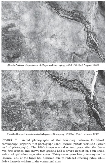
Finally, what historical perspectives are there on the rates of environmental change and how easily could communal area environments be restored if land-use practices were altered? Anecdotal evidence and observations from a 6-hectare exclosure erected in Paulshoek in 1996 suggests that the rocky uplands recover reasonably quickly (perhaps over timespans of a few decades) when fully protected from grazing, and particularly when a reasonably diverse complement of perennial species is present prior to protection. In addition, an historical analysis of aerial photographs suggests that, with a reduction in stock numbers to recommended levels, recovery of the vegetation of the lowland environments is also possible (Figure 7).
Before Paulshoek was enclosed by boundary fences separating private farms from the communal area in the 1960s, borders were porous and farmers grazed in relative freedom within an expanded commons. At this time stocking rates were relatively high both in communal areas and on private farms (Hoffman and Rohde Reference Hoffman and Rohde2007). The impact of grazing was therefore similar for both tenure systems and the aerial photograph taken in 1960 of Kuile, a lowland area on the southern border of Paulshoek, shows little difference in the cover of perennial shrubs between the communal area and adjacent private farm. In 1997, however, following nearly 40 years of relatively low stocking densities on the private farm, an increase in perennial plant cover in the aerial photograph is easily discernible. Field observations at this site confirm the presence of a diversity of perennial shrubs, including many leaf-succulent shrubs (Todd and Hoffman Reference Dahlberg and Blaikie1999). The communal area, however, looks little different from how it appeared in the 1960 aerial photograph, and field observations confirm that it is dominated by Galenia africana and annual plants during high-rainfall years (Todd and Hoffman Reference Dahlberg and Blaikie1999; Mayer 2004).
A series of fifteen repeat photographs depicting croplands, stockposts and grazing areas confirms that much of Paulshoek's pastoral landscape has changed very little since 1940 (see figures 2, 8 and 9). Under the current stocking regime in Paulshoek, however, it is unlikely that perennial leaf-succulent plants will re-establish on the bottom lands, since recruitment is dependent to some extent on the presence of mature adult plants in the vicinity able to provide a source of seed for recolonization. Leaf-succulent species within the family Aizoaceae are notoriously poor dispersers (Parolin Reference Parolin2001) and can take decades to cross even short distances of a few hundred metres. Wind-dispersed diaspores within the Asteraceae, however, are often more widely dispersed and can probably cover hundreds of metres or even kilometres in a single dispersal event. In the absence of reproductively mature adult plants, however, recolonization of transformed lowlands is going to be slow and will probably not occur under current stocking rates.
Discussion
During the twentieth century, the village of Paulshoek, and villages like it across Namaqualand, have been transformed from sparsely populated outstations of subsistence agriculture to nucleated settlements reliant on migrant labour and state welfare. Throughout this time, the lives of villagers have been constrained by increasingly repressive government policies, and disproportionately influenced by events and circumstances far beyond the borders of the communal lands. The endgame of colonialism as played out in the state's takeover of the mission stations in 1913, the great depression which swept the globe in the late 1920s and 1930s, the titling of farms for white farmers in Bushmanland in the late 1930s, the rise of the National Party and its support for white farmers surrounding the communal areas, the promotion of labour reserves in association with commercial agriculture, mining and nationalized industries – all had knock-on effects on the communal environment.
Each scene from the political and socio-economic drama of Paulshoek's history has left a corresponding mark on the surrounding environment. While little direct evidence exists for the changes which accompanied the settlement of the area by peasant farmers in the early part of the twentieth century, some inferences can be drawn from oral histories and comparative studies with well-documented commercial farms on the borders of the reserve. Photographs of the Paulshoek area in the late 1930s and early 1940s, before the village was created, show that the land was already heavily utilized for both grazing and cultivation. The repeats of these photos show that the environment has changed very little since this heyday of agricultural production in the reserve. Just the opposite is the case in the surrounding privately-owned commercial farms. Such fence-line contrasts are an obvious illustration of the dialectical process of landscape change in relation to socio-cultural and political factors. This stark separation in the landscape represents a much deeper and intractable issue of contemporary transformation in South Africa's social and political environment.
The response of the communal population to such external processes and events can be traced in the landscape of villages such as Paulshoek. Reminders of the last days of the colonial ecological revolution, as played out in the aborted ‘economic units’ policy of the 1970s and 1980s, criss-cross the landscape as defunct and broken fences, built in order to enforce the privatization of communal land. This apartheid attempt at ‘land reform’ took place at the cusp of a new post-agrarian era when large tracts of cultivated land were abandoned across Namaqualand in both the commercial and communal sectors (see Bryceson Reference Bryceson1996). Livestock numbers began a steady decline in the commercial sector, largely as a response to government de-stocking schemes and subsidies, whereas the communal areas were largely left out of the loop of agricultural or any other type of development until 1994.
Apart from the obvious decline in the importance of agriculture to the regional economy, the symptoms of a post-agrarian ecological revolution include the increasing importance of conservation in policy and development, and its association with a growing tourist industry. And yet the communal areas lag behind in many important respects, still fixed in the dying phases of apartheid divisions. The process which created the ubiquitous ‘fence-line’ contrasts, so favoured by agricultural advisers seeking to demonstrate the effects of high stocking rates on Namaqualand's communal rangelands, is ongoing even today. On the one side of the fence, the end of agricultural subsidies has led to the exodus of white farmers from the area, where a 30 per cent reduction in occupied farms has occurred during the last eight years alone (May and Lahiff Reference May and Lahiff2007). On the other side, the decline of the mining industry swells the communal population with more unemployed and retrenched labourers, who often seek to reinvest their retrenchment or pension capital in livestock (Anseeuw and Laurent Reference Anseeuw and Laurent2007). Although the population in villages such as Paulshoek has declined slightly during the last ten years, partly due to the concentration and growth of economic and political power in a few large towns such as Springbok, communal stock farmers with few or no other livelihood options continue to eke out a meagre income from the land. As a result, the fence-line contrasts persist. But the post-agrarian ecological revolution in the form of tourist development has come to Paulshoek, which itself now has a tourist camp and several new guest houses. These, however, are occupied for the most part by a newer breed of tourist – academic researchers (including the authors of this article).
During our time in Paulshoek, we have been able to answer many questions about the dialectical relationship of nature, people, land and power. The question of how long it will take to undo the environmental and socio-economic effects of 100 years of separation remains unanswered.
ACKNOWLEDGMENTS
Our gratitude goes first and foremost to the people of Paulshoek, without whose forbearance, intelligence and humour none of this would have been possible. Our thanks, too, to the many generous researchers, officials and friends in Namaqualand whose interest and engagement with the current process of social and political transformation made this research so rewarding. This article was made possible by EU funding under several projects, including ‘;Management and Policy Options for the Sustainable Development of Communal Rangelands and their Communities in Southern Africa (MAPOSDA)’ (INCO, ICA-CT-2001-10050) and ‘Floodwater Recharge of Alluvial Aquifers in Dryland Environments (WADE)’ (GOCE-CT-2003- 506680). The European Commission cannot accept responsibility for any information provided or views expressed. The contribution of BIOTA Southern Africa, sponsored by the German Federal Ministry of Education and Research under promotion number 01 LC 0024A, is also gratefully acknowledged. Finally, we thank the Mazda Wildlife Fund for the use of a courtesy vehicle.
Namaqualand is a relatively poorly defined geographic region in the north-west of South Africa covering about 50,000 square kilometres and straddling two provinces. It stretches from the Orange River in the north to the Olifants River, just south of Van Rhynsdorp, in the south and about 100 to 150 kilometres inland from the Atlantic seaboard. Most of the region prior to 1994 was held under private tenure but several communal reserves (shaded areas) formed discrete islands in the landscape. Paulshoek forms the south-eastern section of the Leliefontein communal reserve

Stockposts within the Paulshoek commons have been a persistent feature of the landscape during most of the twentieth century. The upper photograph was taken by Mr A. J. Andrews in 1938 before the creation of the village of Paulshoek, when most families would have been dispersed in small groups and alternated between seasonal croplands and grazing areas. Today (lower photograph taken 1 March 2004), although building materials have changed, such structures remain movable and semi-permanent

Transhumance routes of Nama livestock keepers in (a) Namaqualand during pre-colonial era c. 1700 (upper map); (b) Leliefontein mission station and reserve during the nineteenth century (centre map); and (c) Paulshoek (and other villages of Leliefontein) today (lower map)

The Kleinfontein school house in 1938 (top photograph) and 1998 (lower photograph). Prior to the creation of Paulshoek the area was heavily impacted by grazing and cropping. Sixty years later there has been little change in ground cover or species composition, due to continued heavy utilization. (Photos by A. J. Andrews and the authors)

The number of large stock units (LSU) in the magisterial district of Namaqualand between 1860 and 1996

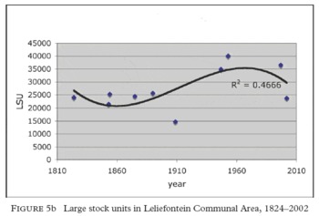
Large stock units in Leliefontein Communal Area, 1824–2002

Rainfall (bars) and sheep and goat numbers in Paulshoek for the period 1971–2004. These two variables are related by the following relationship: y = 12.62x + 01133.7 (where y = number of animals in any one year and x = previous year's annual rainfall total) (n = 26; rFootnote 2 = 0.4217; p < 0.001)

Aerial photographs of the boundary between Paulshoek commonage (upper half of photograph) and Rooiwal private farmland (lower half of photograph). The 1960 image was taken two years after the fence was first erected and shows that grazing had a severe impact on both areas, indicated by the low vegetation cover. Thirty-seven years later, recovery on the Rooiwal side of the fence has occurred due to reduced stocking rates, while little change is evident in the communal area.

(Top photograph taken in 1937, bottom photograph taken in 2005) This stock post has been in continuous occupation since 1937. The invasion of short-lived non-palatable perennials (Galenia africana) is indicative of ecological processes that have occurred throughout the landscape of Paulshoek in disturbed sandy areas during recent decades. Note the persistence of the low dark trees (Rhus undulata) in the rocky areas. These are the most highly valued source of firewood – this image illustrates the sustainable use of this resource. (Photos: A. J. Andrews and the authors)

(Top photograph taken in 1938, bottom photograph taken in 1999) Kleinfontein – threshing floor, croplands and rocky uplands. Note the transformation of the fallow croplands in the mid-ground. Much of this consists of non-palatable perennials (like Galenia africana), although there is some recruitment of long-lived palatable shrubs, indicating that recovery is possible as land-use intensity declines over long timeframes. (Photos: A. J. Andrews and the authors)