

Ἀμφίβιοι γὰρ τρόπον τινά ἐσμεν καὶ οὐ μᾶλλον χερσαῖοι ἢ θαλάττιοι.
For we are amphibious in a sense and are no more tied to land than to sea.
Strabo 1.1.16INTRODUCTION
In the opening of his ‘colossal work’ (κολοσσουργία) on Mediterranean geography, Strabo (1.1.16, 1.1.23) explains that human affairs are inseparable from the sea. This statement, written in the age of Augustus, is similar in tenor to Plato's (Phaedo 109b), nearly four centuries earlier, which likened the inhabitants of the Mediterranean to ‘ants or frogs around a pond’. The idea that life in the ancient Mediterranean was dependent on the sea is also the keystone of a modern colossal study, The Corrupting Sea, in which P. Horden and N. Purcell (Reference Horden and Purcell2000) argue that the Mediterranean operated as a web of interdependent and interconnected microregions. Ancient communities militated against risks (environmental, social, political, economic) by participating in networks of seaborne exchange, which facilitated efficient redistribution of resources across the Mediterranean. The long-term survival and prosperity of any given microregion depended on its seaports, which were the linchpins of Mediterranean interconnectivity (Horden and Purcell Reference Horden and Purcell2000, 393). This model offers an explanation as to why so many cities and the most powerful in antiquity were seaports.
Archaeological investigations of ancient seaports often emphasise issues related to topography and economy, to clarify urbanism and maritime trade (Milne and Hobley Reference Milne and Hobley1981; Goodburn, Jones and Ponsford Reference Goodburn, Jones and Ponsford1991; Parkins and Smith Reference Parkins and Smith1998; Harris Reference Harris2005, Reference Harris2011, 155–87; Morley Reference Morley2007; Robinson and Wilson Reference Robinson and Wilson2011; Rogers Reference Rogers2013, 140–51). Archaeologists have recently broadened their approach by examining the social and cultural context of coastal remains. Nautical archaeology has also yielded valuable evidence through underwater reconnaissance on seafaring, cargoes and the infrastructure of seaports. Marine archaeology, offering a broad exploration of mankind's relationship to the sea, has often been viewed as a subdiscipline of nautical archaeology, rather than as a field integral to the study of ancient urbanism and history (Raban Reference Raban and Raban1988, 9; Dellino-Musgrave Reference Dellino-Musgrave2006). Given the importance of shoreline changes for the development of coastal sites, it is surprising that archaeological research of historical seaports seldom address the subject of historical sea level (Walsh Reference Walsh2014, 30–68). The effects of changing relative sea levels, for example, are not mentioned in a recent monograph entitled Water and Roman Urbanism (Rogers Reference Rogers2013). Excavation projects, in particular, rarely consider sea level when examining site formation processes and never as an environmental force influencing the production of the archaeological record. Historical sea level is more often investigated by multidisciplinary projects dedicated to regional landscape studies and prehistoric archaeology, since survey data is often closely tied to geomorphology (e.g. the Nikopolis Project in north-western Greece: Jing and Rapp Reference Jing, Rapp, Wiseman and Zachos2003; the harbours of Ephesus: Stock et al. Reference Stock, Pint, Horejs, Ladstätter and Brückner2013). With few exceptions (e.g. Brückner et al. Reference Brückner, Herda, Müllenhoff, Rabbel and Stümpel2014; Krahtopoulou and Veropoulidou Reference Krahtopoulou, Veropoulidou, Touchais, Laffineur and Rougemont2014; Reference Krahtopoulou and Veropoulidouin press), historical sea level, as a subject of research, has been the domain of earth scientists and geologists, who grapple with the scientific analyses of eustatic, glacio-hydro-isostatic, and tectonic variables that underlie the evolution of shoreline change over time (Flemming Reference Flemming1969, Reference Flemming1979; Scott, Pirazzoli and Honig Reference Scott, Pirazzoli and Honig1987; Pirazzoli Reference Pirazzoli1976, Reference Pirazzoli1979, Reference Pirazzoli and Raban1988, Reference Pirazzoli1991, Reference Pirazzoli1996; Lambeck Reference Lambeck1995, Reference Lambeck1996; Lambeck and Chappell Reference Lambeck and Chappell2001; Fouache and Pavlopoulos Reference Fouache and Pavlopoulos2005; Marriner and Morhange Reference Marriner and Morhange2007; Walsh Reference Walsh2014). While the phenomenon of plate tectonics is a relatively recent discovery, only becoming widely accepted by geologists in the 1960s, historical changes in sea level have been noted since antiquity and have been investigated systematically since the nineteenth century (Suess Reference Suess1885). Most studies of historical sea levels aim to trace shoreline changes over the Quaternary, rather than over the last two millennia.
All coastal sites in the Mediterranean have been affected by sea level. Some ancient seaports have experienced significant uplift since antiquity, as, for example, those along the north-western coast of Italy on the Tyrrhenian Sea (Lambeck et al. Reference Lambeck, Antonioli, Purcell and Silenzi2004, 1570–80). The majority of ancient seaports in the Mediterranean, however, have experienced subsidence and many are presently fully or partially submerged below sea level, as, for example, in the Aegean and along the western coast of the Balkans on the Adriatic and Ionian seas (e.g. Alexandria, Herakleion, Helike, Kenchreai, Misenum, Baia, Pozzuoli) (Flemming Reference Flemming, Masters and Flemming1983a, Reference Flemming, Masters and Flemming1983b; Raban Reference Raban, Masters and Flemming1983; Sardinas Reference Sardinas, Masters and Flemming1983; Pirazzoli Reference Pirazzoli1991, 93–9; Marriner and Morhange Reference Marriner and Morhange2007; Ghilardi et al. Reference Ghilardi, Fouache, Queyrel, Syrides, Vouvalidis, Kunesch, Styllas and Stiros2008; Walsh Reference Walsh2014, 52–5). A rise or fall in sea level represents a shift in the boundary between land and sea, leading to major changes in the topography, economy, urbanism and microenvironmental conditions of coastal cities over time. In addition to sea level, the long-term formation of coastal zones is also closely tied to processes of erosion, sedimentation and alluviation.
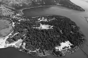
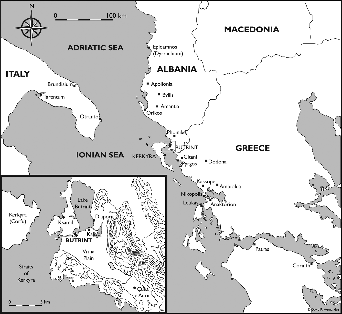
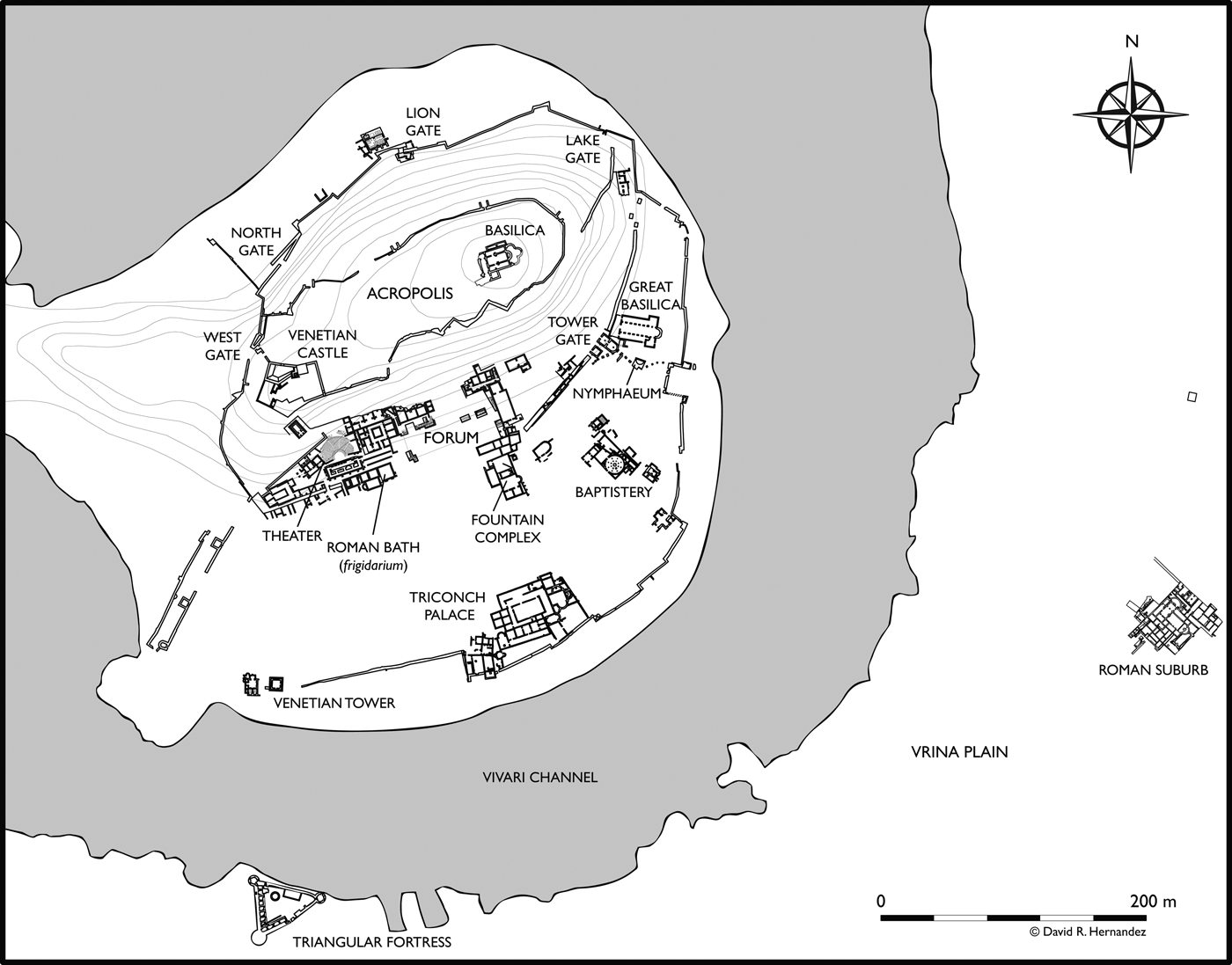
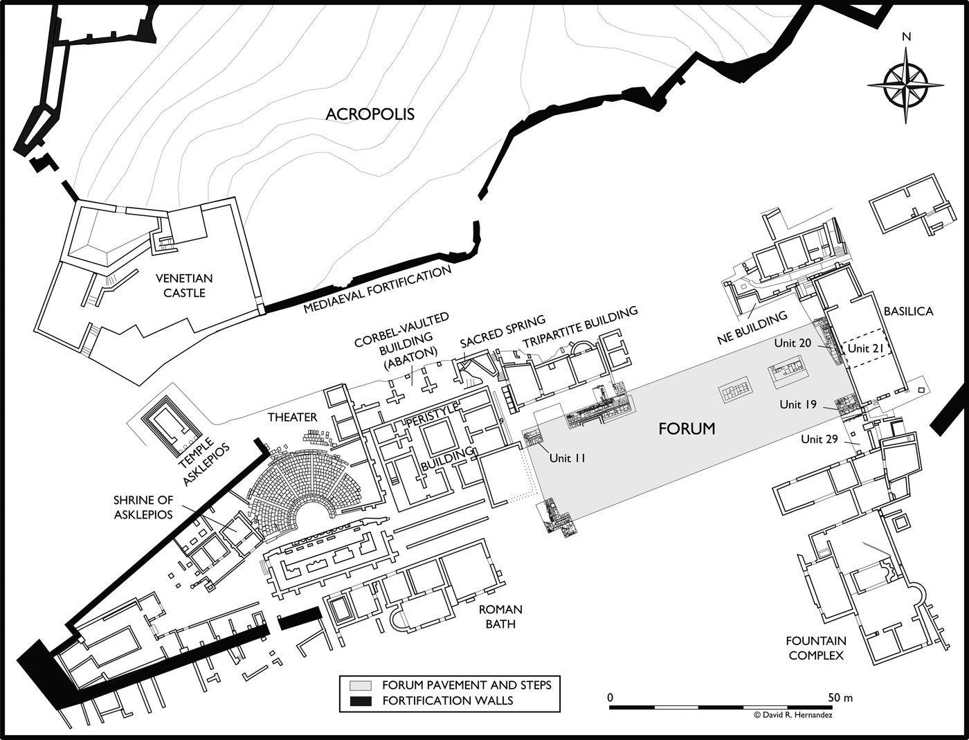
This article presents a case study from the ancient city of Butrint (Bouthrotos/Buthrotum), a UNESCO World Heritage Site located in southern Albania (Figs 1 and 2) (Hodges Reference Hodges2006; Reference Hodges, Hansen, Hodges and Leppard2013a). Habitation at the site is attested archaeologically from the time of the city's foundation in the second half of the seventh century bc until its abandonment in ad 1537 (Hernandez Reference Hernandezin press a, Reference Hernandezin press c). Like many other Mediterranean seaports, the ancient city is deeply buried under thick alluvial deposits and an immense volume of earth and rubble formed from multiple phases of habitation. In the ancient urban centre, the depth of deposition is greater near the foot of the Acropolis and varies between c.6–12 m as measured from the modern surface (Figs 3 and 4).
Butrint (courtesy of the Butrint Foundation).

Map of Butrint and its region.

Butrint plan.

Plan of the Forum and ancient urban centre.

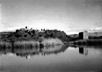
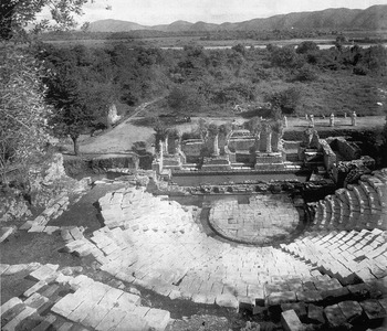
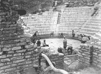
Luigi M. Ugolini began his quest in 1928 to unearth ancient Butrint in the wild environment of thriving wetland (Fig. 5) (Lane Reference Lane2004; Bescoby Reference Bescoby, Hansen and Hodges2007; Reference Bescoby, Hansen, Hodges and Leppard2013; Hodges Reference Hodgesin press). Since the start of his excavations, archaeologists have encountered groundwater and other difficulties excavating in the urban centre. With some areas of the city heavily wooded and others a marsh, Ugolini established a rail system for the transport of spoil and deployed dozens of labourers, who toiled almost year round to expose much of the western end of the urban centre. This work brought to light the Theatre and the Sanctuary of Asklepios (Ugolini Reference Ugolini1937, 116–61; Reference Ugolini1942, 76–146). Ugolini's team reached the water table in every trench in the lower city. At the Theatre, they penetrated up to 60 cm below the water in order to reveal the paved orchestra and the limestone-paved courtyard to the west of the scaenae frons (Fig. 6) (Ugolini Reference Ugolini1937, 40–1; Reference Ugolini1942, 14). Ugolini considered the high water table at Butrint to be detrimental to archaeological research. Subsequent archaeologists, experiencing many of the same struggles posed by the wetlands, have decided to avoid it and have viewed the water table as a limit of excavation. Battling water, archaeologists have shared a universal perception of groundwater as enemy, which obstructs fieldwork, drives up costs, prevents excavation, creates unsanitary work conditions, hinders conservation and destroys material remains.
Butrint marshes, with Venetian Castle (top) and Tower (right), 1932 (courtesy of the Butrint Foundation).

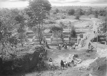
Ugolini's post-excavation photograph of the Theatre, 1932 (courtesy of the Butrint Foundation).

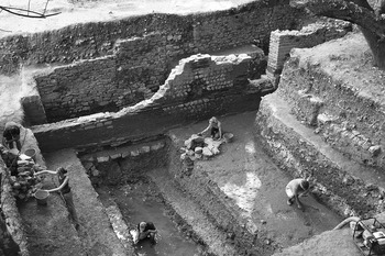
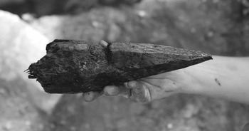
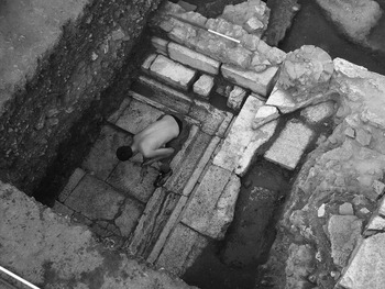
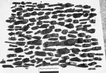
In pursuit of historical narratives concerning Vergil, Illyrians, Atticus, and Augustus, archaeologists have overlooked one of Butrint's most important areas of archaeological research – its wetland and wet-site archaeology. The Roman Forum Excavations (RFE) Project conducted the first wet-site excavations at Butrint, reaching depths of up to four metres below the water table (seven metres below the modern surface) in stratigraphic excavations in the ancient urban centre in 2012 (Fig. 7) (Hernandez and Çondi Reference Hernandez, Çondi, Përzhita, Gjipali, Hoxha and Muka2014; Hernandez and Çondi Reference Hernandez, Çondi, Cabanes and Lamboleyin press). The waterlogged deposits have yielded important evidence not only for the earliest urban phases of Butrint, but also for the formation processes of the Butrint headland (Hernandez Reference Hernandezin press c). By preserving organic materials extremely well in anaerobic conditions, the waterlogged deposits have furnished a new range of important archaeological material, such as wood, seeds, leather, hair and textile (Fig. 8).
Wet-site excavations in Unit 21 at the Roman Basilica; RFE Project Excavations, 2012.

The share of a wooden plough (3rd century bc), discovered in Unit 21; RFE Project Excavations, 2012.

In Albania, wet-site excavations have been undertaken, to an extent, at a cluster of sites at Maliq and Sovjan, located on the western edge of the Korça Basin in the south-eastern part of the country. The basin is situated c.800 m above sea level and was submerged by Lake Maliq. After the drainage of the lake in the 1950s, Albanian archaeologists excavated Neolithic lakeside wood-pile dwellings at Maliq in dryland conditions (Prendi Reference Prendi1966; Aliu Reference Aliu, Bejko and Hodges2006, 43–9). In the case of Sovjan, the site is a submerged tell that came to light when an irrigation canal (116 m wide) was dug through it in 1988 (Lera and Touchais Reference Lera and Touchais2002; Reference Lera, Touchais, Gjipali, Përzhita and Muka2013). Excavations, conducted adjacent to the canal by a joint French and Albanian team, have revealed wood dwellings from the Bronze Age and archaeobotanical remains as early as the Early Neolithic period (seventh millennium bc). At Sovjan, the depth of wet-site excavation and the dewatering systems employed were minimal. The lower waterlogged deposits of the trenches were drained with a small pump. Small seasonal fluctuations (c.20 cm) in the water table created ‘difficult conditions’ during excavation (Lera, Prendi and Touchais Reference Lera, Prendi and Touchais1997, 874). More recent explorations of waterlogged palaeoenvironmental remains have been undertaken at the nearby site of Vashëti by SANAP (Southern Albania Neolithic Archaeological Project) and at Maliq by PALM (Palaeo-Archaeological Survey of Lake Maliq), both of which have focused on coring and excavation of small test trenches rather than large-scale open-area excavation (Allen and Gjipali Reference Allen, Gjipali, Përzhita, Gjipali, Hoxha and Muka2014; Fouache et al. Reference Fouache, Desruelles, Magny, Bordon, Oberweiler, Coussot, Touchais, Lera, Lezine, Fadin and Roger2010). In many ways, the wet-site excavations and methodology of the RFE Project are novel to archaeology in Albania.
The aim of this article is not to examine the wet-site archaeology of Butrint in detail. The methodology of the RFE Project and the results from wet-site excavations at the site of the Roman Forum are being published in a series of articles (Hernandez Reference Hernandezin press a, Reference Hernandezin press b, Reference Hernandezin press c). The purpose of the article is to show that archaeological research and interpretation at Butrint have been inextricably tied to the sea. The article examines the prevailing methodological paradigms of archaeologists at Butrint and the profound influence of the water table (sea level) on the production of the archaeological record. The water table has not only conditioned archaeological objectives, but also has framed the execution of fieldwork and the interpretation of archaeological material. The article lays the conceptual foundation for the development of a new frontier of research at Butrint in wet-site archaeology.
FRAMING THE PROBLEM: THE DISCOVERY OF THE ROMAN FORUM
L'acqua d'infiltrazione (che non è possibile incanalare o deviare) è molto dannosa alla conservazione dei monumenti, rende penoso e assai costoso lo scavo e talvolta addirittura lo impedisce. In una zona priva d'alberi, posta tra il frigidario e il battistero, credo che possa esistere un grande monumento romano, o, meglio, forse il Foro. Qualche colonna di granito più superficiale è già stata trovata. Ma lo scavo qui riuscirebbe difficilissimo. Si pensi che, su questa zona, l'acqua ristagna costantemente per un'altezza media di 30 cm.
The infiltrating water (which cannot be diverted or channelled) is very damaging to the conservation of the monuments, makes excavation very difficult and expensive and sometimes even prevents it. In an area free of trees, situated between the frigidarium (of the Roman Bath) and the Baptistery, I think there might be a great Roman monument, or rather, perhaps the Forum. A few granite columns have already been found on the surface. But an excavation here is most difficult to succeed. If you consider that, in this area, the water stagnates constantly within a range of 30 cm.
(Ugolini Reference Ugolini1937, 45)On the morning of 15 July 2005, groundwater inundated Unit 11 (Fig. 4). The RFE Project had been excavating for six weeks in the ancient urban centre, at the site of the Tripartite Building (Roman shrines), located adjacent to the Theatre and Sanctuary of Asklepios. The team continued excavation, bailing water from the trench with buckets. The removal of the first waterlogged deposit exposed an L-shaped course of ashlar blocks that enclosed the eastern corner of the trench in a square. By the afternoon, at 2.1 m down from the surface, white limestone pavement slabs came to light, framed by a stone gutter and two steps. The discovery was the Roman Forum of Buthrotum (Fig. 9) (Hernandez and Çondi Reference Hernandez and Çondi2008, Reference Hernandez, Çondi, Cabanes and Lamboley2010).
North-western corner of the Forum, Unit 11; RFE Project Excavations, 2005.

During this same season of fieldwork, Albanian archaeologist Neritan Ceka was directing excavations also in search of the Roman Forum, in dense woods located about 70 m to the east, where a monumental inscription of Germanicus Caesar had been discovered in 1977 (Pollo Reference Pollo1988, 213–15; Ceka Reference Ceka, Bejko and Hodges2006; Anamali, Ceka and Deniaux Reference Anamali, Ceka and Deniaux2009, 196).Footnote 1 Ceka's four trenches were deep vertical shafts, about two metres down from the surface, by the time they reached the water table in 2005. Unable to excavate Roman deposits because of groundwater, his team reached a basal level that dated no earlier than the fifth century ad. However, two Roman walls in opus mixtum had emerged, each imbedded within a section of a trench. Owing to the water table, excavation was discontinued and the trenches were abandoned.
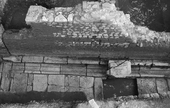
Seven years later, in 2012, the RFE Project recommenced excavations in this area (Units 20 and 21). After the discovery of the Forum's north-western corner in 2005, subsequent fieldwork campaigns were undertaken to reveal the Forum's topography (Hernandez and Çondi Reference Hernandez, Çondi, Përzhita, Gjipali, Hoxha and Muka2014; Reference Hernandez, Çondi, Cabanes and Lamboleyin press). Ceka's team would have revealed the precise location of the eastern end of the Roman Forum, had they excavated an additional 1.4 m below the water table. The two Roman walls exposed in section were shown to belong to a single building, the Roman Basilica at the head of the Roman Forum (Fig. 10).
Eastern end of the Forum, showing the Roman Basilica and Statue Base in Unit 20; RFE Project Excavations, 2012.

These conditions and problems, arising from groundwater, were also faced by Butrint's first excavators. Ugolini presented the team's struggle with l'acqua d'infiltrazione as a dramatic theme in his published narrative of the fieldwork (Ugolini Reference Ugolini1937, 43–5, 56–8; Reference Ugolini1942, 12–15; Reference Ugolini and Gilkes2003, 76–9; Ugolini and Pojani Reference Ugolini, Pojani and Gilkes2003, 198–9). He recounts the difficulty of excavating in the mud, the ruinous condition of the finds due to corrosion and disintegration, the expense of the work and the inability to conserve certain monuments. Above all, he laments that groundwater prevented excavation. In Butrinto: Il mito d'Enea. Gli Scavi (Reference Ugolini1937), at the end of a chapter entitled ‘Difficulties encountered in the work’ (Difficoltà incontrate nei lavori), Ugolini speculates on the location of the Roman Forum (quoted above). After discussing the problems of excavation in the urban centre due to the depth of deposits and groundwater, Ugolini (Reference Ugolini1937, 45, 148–9; Reference Ugolini1942, 46, 76–80) proposes a location for the Forum that is a short distance to the south-west of the Fountain Complex.Footnote 2 Conducting trial excavations in the area to locate the Forum, he discovered an architrave block and columns of grey granite, and thought that they belonged to a major Roman building in the Forum.Footnote 3 Ugolini considered the enterprise to locate the Forum as futile, however, on account of groundwater.
Ugolini's calculation of 30 cm for the fluctuation of the water table corresponds precisely to the tidal range known from modern geological studies (Negroni Reference Negroni2001; Hounslow and Chepstow-Lusty Reference Hounslow and Chepstow-Lusty2004). He took regular measurements of the water table, and this factored into his excavation plans in the lower city (Ugolini Reference Ugolini1942, 12–19). For example, he measured the water level at the Vivari channel and at the Theatre on 19 July 1930 at 9.30 a.m. (Ugolini Reference Ugolini and Gilkes2003, 79). In short, Ugolini discloses that the water table was the reason why he chose to abandon his search for the Forum (Ugolini Reference Ugolini1942, 13). He thought that the undertaking would be too expensive, difficult and long, involving the development of cumbersome hydraulic systems to combat groundwater. It has gone unnoticed that Ugolini was pursuing a master plan at Butrint: to excavate the entire area between the Theatre and the Baptistery by extending the trench at the Theatre eastward (Fig. 3) (Ugolini Reference Ugolini1937, 59–60). Had he succeeded, he would have discovered the Forum. Ugolini's trench ultimately reached no further than the eastern end of the Peristyle Building and the Roman Bath. Sea level terminated Ugolini's enterprise.
VISIONS OF AENEAS: THE ITALIAN ARCHAEOLOGICAL MISSION
Ugolini first arrived at Butrint alone in the spring of 1924 (Ugolini Reference Ugolini1927, 153–7; 1937, 15–22). As the first director of the Italian Archaeological Mission to Albania, having been appointed to this post earlier in the same year by the Italian Foreign Ministry, Ugolini was exploring the archaeological landscape of southern Albania. He arrived at Lake Butrint in search of the kingdom of Helenus and Andromache, the legendary Trojan founders of Butrint. Ugolini developed a burning ambition to discover the Vergilian city. His aims were similar to Schliemann's, to use archaeology to reveal a core truth in the Aeneid (Hodges Reference Hodges and De Maria2012, 55–6). While conceding that the poem should not be interpreted literally, he believed that its narrative outline was true and that Trojan exiles arrived in the Balkans and in Latium after the sack of Troy (Ugolini Reference Ugolini1937, 68–80). The principal aim of his archaeological campaign was to recapture the material that belonged to the glorious golden age of Augustus in which the Aeneid was written (Gilkes Reference Gilkes and Gilkes2003, Reference Gilkes, Galaty and Watkinson2004; De Maria Reference De Maria2006; Magnani Reference Magnani, Magnani and Marcaccini2007). The city had the historical distinction of being a Roman colony under Augustus, which lent greater importance to that particular period in the city's history.
The near-perfect alignment of the imperialist agenda of fascist Italy and Ugolini's research programme helps explain the financial and political support that his expedition received from the Italian government. Ugolini met with Mussolini on several occasions, and both men came from the same region of Romagna in northern Italy. His ascent in academia was in step with the rise of fascism.
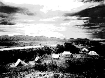
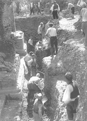
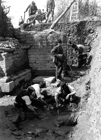
The first two years of excavation (1928–9) were marked by severe shortages in provisions, fresh water, tools, archaeological equipment and skilled personnel (Ugolini Reference Ugolini1937, 22–38, 43–5; Reference Ugolini and Gilkes2003, 75–8). Water had to be transported by mule over a four-hour trek from a spring in the village of Çuka, near Santa Quaranta, c.12 km away. During excavation, his Albanian workers drank semi-salt water from the lake or from reopened Venetian wells. Water became the source of other problems. As spring advanced, mosquitoes became a primary health concern. Together with heat and humidity, malaria made Butrint inhospitable in the summer (Fig. 11). The excavations at the Theatre necessitated the removal of a large amount of earth, which was transported by wooden wheelbarrows in these initial years. In a letter to Mussolini dated 20 June 1928, Ugolini reports that the trench measured 15 × 4 m in area and was 5 m deep (Fig. 12) (Miraj Reference Miraj and Gilkes2003, 36, document 5). The intensity, speed and scale of the excavations are made clear by the fact that this work had only begun at the end of May (Ugolini Reference Ugolini and Gilkes2003, 75).
Ugolini's camp on the Acropolis (Courtesy of the Butrint Foundation).

Ugolini's excavation trench adjacent to the scaenae frons, 1928 (courtesy of the Butrint Foundation).

The focus of the excavations was the site of the Theatre and Sanctuary of Asklepios (Fig. 13). The hardships faced by the team were magnified upon reaching the water table. Ugolini (Reference Ugolini1937, 44) describes it as a ‘fight against the infiltrating brackish water from the lake’ (lottare contro le forti infiltrazioni dell'acqua salmastra del lago). Ugolini hired 20 workers for the sole purpose of bailing water from the trenches with buckets. A fresh crew would arrive in the afternoon to relieve the beleaguered labourers who toiled in these conditions throughout the day. He complains in a letter to Mussolini about the difficulties posed by the infiltrating water and laments not having a pump. By early July, he writes that the lack of drinking water was particularly hard on the workmen, that it was hot, and that malaria had broken out among the team. Despite the remarkable discoveries made during these months of excavations, Ugolini reluctantly withdrew from Butrint for most of July and August owing to these conditions (Miraj Reference Miraj and Gilkes2003, 32). He describes the climate as dangerous (clima pericoloso) in a telegram sent to Tirana from Santa Quaranta on 17 June 1928 (Miraj Reference Miraj and Gilkes2003, 35, document 4).
Excavation of the Theatre's cavea, 1929 (courtesy of the Butrint Foundation).

Ugolini came to realise that his visions of Aeneas lay in these waterlogged deposits. He found almost two dozen Greek and Roman sculptural pieces while excavating beneath the water table in the Theatre (Ugolini Reference Ugolini and Gilkes2003, 198–246; Ugolini and Pojani Reference Ugolini, Pojani and Gilkes2003, 195–6, 246–52).Footnote 4 The team spent considerable time in the mud, working slowly with wooden tools to avoid damaging the items as they were extricated from the ground. Every piece of stone had to be washed and inspected by the Italians to make sure that sculpture and inscriptions were not accidentally discarded. The mud was sieved to recover smaller artifacts. Ugolini wrote that the trench at times looked like a battlefield, with bodies (of sculptures) strewn about (Ugolini Reference Ugolini and Gilkes2003, 211).
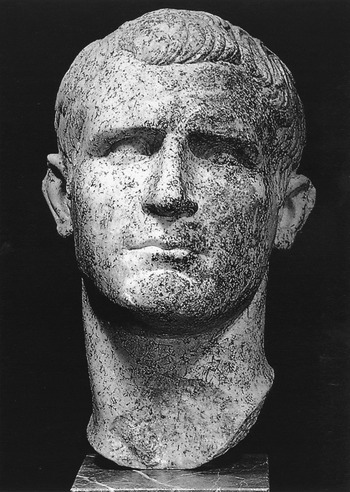
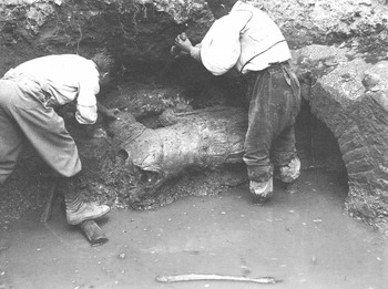
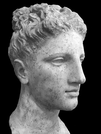
The finds included one of the best-preserved marble portrait busts of M. Vipsanius Agrippa, the famed naval commander who won the battle of Actium in 31 bc for Octavian (Augustus) over the forces of Marcus Antonius and Cleopatra (Fig. 14) (Ugolini Reference Ugolini1932). A photograph vividly illustrates the excavation work, showing Ugolini and an Albanian worker, who stands in a pool of water, extracting the headless cuirassed torso of a Roman statue (Fig. 15) (Ugolini Reference Ugolini1937, 44 fig. 29).Footnote 5 The excavations recovered marble portraits of Augustus and the emperor's wife, Livia, in addition to notable pieces of Asklepios, a Roman woman (Herculanium-type), a Muse, Mercury, and Apollo (Figs 16 and 17) (Ugolini Reference Ugolini1937, 37–148; Bergemann Reference Bergemann1998, 18–66, 125–61; Ugolini and Pojani Reference Ugolini, Pojani and Gilkes2003). At least a dozen other sculptures were discovered in other excavated areas of the city as well. Below the sculptures and the mud, they discovered the pavement of the orchestra in situ, buried 6–8 m from the original modern surface. Groundwater prevented Ugolini from examining the lowest levels of the Theatre to ascertain its original construction date (Ugolini Reference Ugolini and Gilkes2003, 79; Wilkes Reference Wilkes and Gilkes2003, 114).
Bust of Agrippa, discovered at the Theatre (courtesy of the Butrint Foundation).

Ugolini (left) extracting a statue of a Roman general at the Theatre with a local worker, 1928 (Courtesy of the Butrint Foundation).

Bust of Apollo, discovered at the Theatre (the so-called ‘Dea of Butrint’).

Discovery of a female statue at the Theatre, 1928 (courtesy of the Butrint Foundation).

In 1930, Ugolini (Reference Ugolini and Gilkes2003, 32) acquired a motorised water pump, without which it would have been impossible to drain the Theatre and other areas of the ancient urban centre to study and photograph its architecture (Fig. 18). Ugolini (Reference Ugolini1942, 14) had acquired a hand-driven water pump previously, probably in 1929, but it proved insufficient to drain the Theatre. He obtained metal pulleys and various other items of equipment, all of which fundamentally changed the nature and pace of fieldwork.
Ugolini draining the Theatre, 1932 (courtesy of the Butrint Foundation).

Excavation of the Theatre was completed shortly before 26 February 1932, but expansion of the Theatre trench continued, according to Ugolini's master plan. The trench unearthed most of the Peristyle Building and part of the Corbel-Vaulted Building, located north of it (Wilkes Reference Wilkes and Gilkes2003, 134–8, 163, figs 6.35–40, 6.69–70). The excavation joined his two trenches at the Theatre and Roman Bath into one large open square. As he sought to reach surface levels of the Roman period, Ugolini continued to encounter groundwater. It is now clear from the fieldwork experiences of the RFE Project in the urban centre that the larger his trench became, the more difficult it would have been to drain, because the volume of water in a trench increases directly in proportion to the size of the trench (discussed below). It is likely that at this juncture Ugolini reached the dewatering capacity of his pump and came to realise that he would need additional pumps to proceed with large, open-area excavation in the lower city. A continuous trench running from the Theatre to the Baptistery would have required at least 20 times the dewatering capacity of his pump. It is worth noting that it had taken Ugolini nearly two years of written requests to receive the pump that his team was using at the time. It was the practical problem of dewatering, specifically, that forced Ugolini to abandon his master plan.
The Theatre was Ugolini's focal point in thinking about the water table. It was in the Theatre trenches where he first grappled with water during excavation. It became the place where he took measurements over time to track its seasonal oscillations. The pavement of the orchestra, in particular, was used as a benchmark to gauge the behaviour of the water table (Ugolini Reference Ugolini1937, 40–1; Reference Ugolini1942, 12–16; Reference Ugolini and Gilkes2003, 79).Footnote 6 He recognised that the water table had risen since Early Roman times, as the pavement must have been laid on dry ground. He reasoned that the relative rise in sea level was due to subsidence of the Butrint headland, identifying the slow downward movement of land over time as a process of bradyseism (Ugolini Reference Ugolini1937, 40–2; Zuber Reference Zuber and Ugolini1942).Footnote 7 The process of land movement might not have been a linear progression, he thought, since some periods could have experienced greater degrees of subsidence than others, owing to, for example, seismic activity. Ugolini observed that the southern bank of the Vivari channel had receded at a rate of about 1 m per year during the five years since he first visited, citing photographs of the landscape taken in 1924 as evidence. These particular marshes, formed by flooding and alluvial depositions in the past, were now eroding into the Vivari channel. The wetland environment was dynamic, driven by the force of water. These changes led him to conclude that the morphology of the landscape had probably changed significantly since ancient times.
He speculated, on the basis of local accounts, whether major areas of the ancient city had sunk beneath Lake Butrint (Ugolini Reference Ugolini1942, 46). He associated these conditions with the multiple levels of floors, which he encountered during the excavations of the medieval church at the Fountain Complex (Ugolini Reference Ugolini1937, 166–7; Mustilli Reference Mustilli1941, 692). He wondered if the inhabitants at some point in the medieval period began to construct dwellings on the slope of the Acropolis because the lower areas of the city had become bogged. These astute observations, however, were never formulated into a coherent archaeological theory or pursued in any way beyond conjecture. Not discussing excavated deposits in a systematic and meaningful way or recording their superposition by illustration (sections), Ugolini never attempted to interpret the burial of the Theatre, for example, or to seek evidence for the formation of deposits. He was content to propose hypothetical scenarios that came to mind, such as whether the statues in the Theatre fell due to an earthquake or were deliberately brought down by human action. Ugolini's outlook is exemplified at the conclusion of his discussion of bradyseism at Butrint. He notes that this geological process is important to consider for one who wishes ‘to study the ancient topography of Butrint and to attempt to identify modern places with those recorded by Vergil in his long description of the Buthrotum of Helenus and Aeneas’ (Ugolini Reference Ugolini1937, 42).
Not long after Ugolini's untimely death in 1937, Domenico Mustilli became director of the Italian Archaeological Mission. The Fountain Complex was one of the last sites excavated at Butrint by the Italian team. Mustilli (Reference Mustilli1941, 693) reports that excavations at the Fountain Complex had to be abandoned because of groundwater.
REFLECTIONS OF ILLYRIANS: ALBANIAN EXPEDITIONS
A Stalinist-oriented communist government took form in Albania immediately after the Second World War (Vickers Reference Vickers1999, 163–236). Enver Hoxha reached power in 1946, as the First Secretary of the People's Republic of Albania. The ideology of the new regime was rooted in nationalism and grew in opposition to foreign powers. In Hoxha's mind, Albania had been hobbled historically not only by modern Western nations, but also by the ancient Greeks, Romans, Byzantines, Venetians and Ottomans. Archaeology received a new prerogative. It was to contribute overtly to the formulation of national identity. Archaeologists were encouraged to focus their research on the origins and culture of the ancient Illyrians, considered to be the direct ancestors of the Albanian people (Anamali Reference Anamali and Buda1984; Wilkes Reference Wilkes1992, 10–12; Korkuti and Petruso Reference Korkuti and Petruso1993; Miraj and Zeqo Reference Miraj and Zeqo1993; Bejko Reference Bejko1998, 200–8; Korkuti Reference Korkuti1998, 26–9; Bowden Reference Bowden2003, 30–1; Gilkes and Miraj Reference Gilkes, Miraj and Gilkes2003, 46; Galaty and Watkinson Reference Galaty, Watkinson, Galaty and Watkinson2004, 8–12; Hodges and Bejko Reference Hodges, Bejko, Bejko and Hodges2006; Veseli Reference Veseli, Bejko and Hodges2006; Ceka Reference Ceka2013, 19–30).
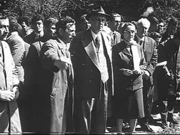
In 1956, Dhimosten Budina was assigned the study of Butrint for his doctoral thesis (Fig. 19). He would become the official director at Butrint and oversee archaeological research over an extensive region of south-western Albania until 1990 (Korkuti Reference Korkuti, De Maria and Gjongecaj2005, 18–21; Hodges et al. Reference Hodges, Bowden, Gilkes and Lako2004, 7; Hodges Reference Hodges2006, 44–7). Budina (Reference Budina1959, Reference Budina and Ceka1988, 23) first excavated an area of the ancient necropolis on Mount Kepin, opposite the small gulf north of the Butrint headland. In the early 1960s, the Vrina plain was cleared of vegetation for agricultural use and later drained in the mid-1970s with dykes and a pumping station in order to end its seasonal flooding (Pluciennik Reference Pluciennik2004, 47–9; Crowson and Gilkes Reference Crowson, Gilkes, Hansen and Hodges2007, 119). In the summer of 1962, Budina undertook an extensive survey of the Vrina plain to examine the Roman aqueduct of Butrint (Budina Reference Budina1967). In the same season, he conducted his first fieldwork within the ancient city, on the northern side of the hill, at a site next to the Lion Gate. From 1963 to 1982, Budina (Reference Budina1971, 336; 1988, 24–30, 58–60, 75–7) directed intermittent excavations on the northern slopes of the Acropolis and on a complex of buildings near the Theatre that included the ‘Prytaneion’, Peristyle Building, and Corbel-Vaulted Building. From 1976 to 1978, he examined and excavated segments of Butrint's multiphase fortification walls, research that led to the discovery in 1977 of the so-called Tower of Inscriptions (Drini and Budina Reference Drini and Budina1981, 227–8, 232; Drini Reference Drini1984, 101; Budina Reference Budina and Ceka1988, 25; Cabanes and Drini Reference Cabanes and Drini2007, 59, 125–72). Budina published very little of his work at Butrint and left unpublished his most important excavations at the site (e.g. the ‘Prytaneion’, Peristyle Building, Corbel-Vaulted Building, and Tower of Inscriptions) (see Korkuti Reference Korkuti, De Maria and Gjongecaj2005, 21–2). The principal publication for his research at Butrint is a long article in Butroti (Budina Reference Budina and Ceka1988).
Dhimosten Budina (left) and Enver Hoxha (right) at Butrint (courtesy of the Butrint Foundation).

Budina's excavation methodology was similar to Ugolini's, based on spits, which represent the removal of standard units of volume in bands, typically to a vertical depth of about 10 cm. This system remained standard practice in Albania until the introduction of stratigraphic excavation by the British team of the Butrint Foundation.Footnote 8 Albanian archaeologists generally believe that their projects were well funded under communism. This is true only in a relative sense. Given the poverty and isolation of the country, the resources available for fieldwork were in many respects quite limited. Good tools and basic archaeological equipment, such as dumpy levels, theodolites, trowels and cameras, were generally lacking. Photographs of the largest Albanian field campaign at Butrint in 1982, for example, are inferior in quality to those taken by Ugolini in the 1930s (Budina Reference Budina and Ceka1988, 25–6; Pani Reference Pani2001, 18–19). Most projects also lacked skilled personnel to study properly the range of material unearthed. Unskilled labour, on the other hand, was plentiful. It was not uncommon, for example, for projects to employ thirty workmen for three or four months of continuous excavation.
There is a pattern, an underlying methodological principle tied to the water table, that can now be discerned in regard to Budina's methodology of fieldwork at Butrint. All his excavations were situated on high ground, at sites on or near the northern and southern slopes of the Acropolis and at ancient cemeteries on Mounts Kepin and Sotirës. In instances where he investigated sites outside of these areas, a substantial portion of a monument's superstructure existed above ground. Wherever there was an opportunity to expose major pre-Roman monuments by removing Late Antique and Medieval deposits, Budina would excavate down to the depth of the water table and then stop (e.g. at the ‘Prytaneion’, Aqueduct, Peristyle Building, Fortification Wall, Tower of Inscriptions).
Budina avoided groundwater, and this explains why he chose not to concentrate his research at Butrint. Most of his time and research funds were invested elsewhere, primarily at Antigonea, the ancient city which he excavated intensively during a series of campaigns from the 1960s to the 1980s (see Zachos et al. Reference Zachos, Çondi, Dousougli, Pliakou, Karatzeni, Bejko and Hodges2006, 381). Antigonea is a hilltop site, like Gajtan and others, where he conducted some of his earliest excavation work (Korkuti Reference Korkuti, De Maria and Gjongecaj2005, 19). Budina was interested in studying the archaeology of pre-Roman Epeiros (southern Albania and north-western Greece), which, in his view, represented Illyrian culture. Excavation in the lower city of Butrint would have involved the removal of more than two metres of Late Antique and Medieval deposits before reaching the water table. Since Roman deposits were waterlogged, pre-Roman levels were quite deep, typically over one metre below the water table. On the Acropolis, Roman construction had disturbed or destroyed most traces of earlier activity, and Roman deposits themselves were equally deep, often beneath two or more metres of later deposits. Given the expense, effort and resources needed to reach undisturbed pre-Roman layers, Butrint was not considered suitable for the search for ‘Illyrians’. The water table explains why Budina favoured the Hellenistic city of Antigonea, with pre-Roman deposits directly below topsoil, over Butrint.
UNCHARTED WATERS: THE BUTRINT FOUNDATION
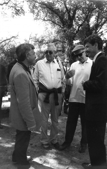
When communist regimes toppled across Eastern Europe, Albania's insular communist government began to fracture. Sweeping democratic reforms in 1991 facilitated official relationships with foreign countries and institutions. In 1993, Lord (Jacob) Rothschild and Lord (John) Sainsbury founded the Butrint Foundation, with an aim to examine the archaeology of Butrint and to protect and to conserve its ruins and natural environment (Payne Reference Payne2003, 2; Hodges Reference Hodges2006, ix). Richard Hodges, the Director of the British School at Rome (1988–95), served as Scientific Director of Archaeological Research for the Foundation, initiating the Anglo-Albanian Archaeological Project (Fig. 20).
(Left to right) James Wolfensohn (World Bank), Lord Sainsbury, Lord Rothschild and Richard Hodges at Butrint, 1995 (courtesy of the Butrint Foundation).

As a medieval archaeologist who had spearheaded projects in England and Italy, Hodges implemented a sophisticated archaeological programme that was closely coordinated with the overall mission of the Foundation, to transform Butrint into a major research centre and first-rate archaeological park. Through a partnership between the Butrint Foundation and the Packard Humanities Institute, he sustained the largest archaeological and cultural heritage project in the country for over 15 years, from 1994 to 2008, during a period when Albania was most precarious and unstable (Hodges Reference Hodges, Hansen, Hodges and Leppard2013b; Reference Hodges2017; Hodges and Paterlini Reference Hodges and Paterlini2013). From the outset, the Butrint Foundation faced tremendous challenges trying to establish itself in a country that had only recently emerged from decades of isolation, political polarisation and poverty. In 1994, Hodges and his team set a course through these uncharted waters.
A principal objective of the research programme was to examine Butrint's Late Antique and Medieval phases, periods which had received marginal study in the past. Excavations were undertaken at the Baptistery and Triconch Palace between 1994 and 1998 (Hodges et al. Reference Hodges, Saraçi, Bowden, Chiles, Gilkes, Lako, Lane, Martin, Mitchell, Moreland, O'Hara, Pluciennik and Watson1997, 224–9; Bowden and Mitchell Reference Bowden and Mitchell2004; Bowden and Përzhita Reference Bowden and Përzhita2004b; Mitchell Reference Mitchell2008). At the Baptistery, archaeologists were unable to recover stratified material remains from deposits associated with the Baptistery's construction on account of groundwater. William Bowden, Project Field Director, reported that
further excavation was severely limited by the level of the groundwater within the Baptistery area, which is such that the Baptistery itself is often partially submerged. Consequently, in only one instance was it possible to reach the original exterior ground level of the Baptistery and no archaeological deposits were excavated that pre-dated the construction of the Baptistery. All the excavated deposits in fact relate to the later medieval use of the Baptistery area. (Bowden and Përzhita Reference Bowden and Përzhita2004b, 181, fig. 10.6)
The emphasis of research during this time was the Triconch Palace, which saw a second phase of excavations between 2000 and 2003 (Hodges et al. Reference Hodges, Bowden, Gilkes and Lako2000; Bowden, Hodges and Lako Reference Bowden, Hodges and Lako2002, 201–9; Hodges, Bowden, and Lako Reference Hodges, Bowden and Lako2004; Bowden and Hodges Reference Bowden and Hodges2011). According to Hodges (Reference Hodges2011a, vii),
The Triconch Palace excavations at Butrint seemed a wonderfully simple endeavour when in 1993 we first agreed with our Albanian colleagues to work here … Only in time did we comprehend the difficulties of excavating in thick woodland that was regularly waterlogged by the higher water-table, and suffered from a stifling humidity because the trees screened off the afternoon breezes from the Ionian Sea.
Like the Baptistery, excavations of the Triconch Palace were obstructed by the water table. The earliest phases of the complex were not clearly identified (Gilkes and Lako Reference Gilkes and Lako2004, 154–5; Bowden and Mitchell Reference Bowden, Mitchell, Lavan, Özgenel and Sarantis2007, 459). Groundwater prevented excavation of deposits dating earlier than the second century ad (Bowden et al. Reference Bowden, Francis, Gilkes and Lako2011a, 11). The walls and floor levels of mosaics, which formed part of the third–fourth century ad complex (phase 2), were unable to be dated by stratified material assemblages because the water table prevented excavation of contemporary and earlier deposits (Hodges, Bowden and Lako Reference Hodges, Bowden and Lako2004, 16; Bowden et al. Reference Bowden, Francis, Gilkes and Lako2011a, 14; Mitchell Reference Mitchell2011, 242).
Although the water table presented difficulties, it did not prevent the project from pursuing its primary objective to examine the period between ad 400 and 1500 (Hodges et al. Reference Hodges, Saraçi, Bowden, Chiles, Gilkes, Lako, Lane, Martin, Mitchell, Moreland, O'Hara, Pluciennik and Watson1997, 209). Hodges’ team developed a strategy in order to minimise the impediments posed by the water table, by excavating the lowest layers of the site at the peak of summer in July. Typically, the water table reached its lowest annual level at that time, after falling gradually from its maximum in spring, the result of thawing on Epeiros’ mountains. This strategy allowed the team to excavate some Late Antique and Early Medieval deposits that otherwise would have been waterlogged during other months of the year.
At the Triconch Palace, excavations identified a period of flooding and/or abandonment in the second half of the fifth century ad, represented by a sterile green-grey silt deposit (Bowden and Mitchell Reference Bowden, Mitchell, Lavan, Özgenel and Sarantis2007, 466, 469; Bowden et al. Reference Bowden, Francis, Gilkes and Lako2011b, 66, 76; Bowden, Cerova, Crowson and Vaccaro Reference Bowden, Cerova, Crowson and Vaccaro2011, 174; Bowden Reference Bowden2011b, 306–7). During this period, the large-scale building programme of the Triconch Palace came to an end before its completion and the site became temporarily abandoned, probably due to flooding. In an earlier phase of the complex, the domus, built c.ad 400, had a floor level almost half a metre higher than that of its predecessor, an arrangement which appears to have resulted from an increase in relative sea level (Bowden Reference Bowden2011a, 299). Ugolini (Reference Ugolini1937, 41) observed a similar sequence of floor levels in the medieval church at the Fountain Complex that he likewise attributed to rising water. Hodges (Reference Hodges2011b, 319, 324) notes that seasonal flooding may have contributed to the sporadic occupation of the Triconch Palace and its adjacent building, the Merchant's House, during the thousand-year period after its abandonment in the seventh century ad. Thus, Bowden and Hodges began to link the Late Antique and Medieval development of the Triconch Palace to periodic episodes of inundations from increased water levels.
In 2000, the Butrint Foundation began a second phase of research, marked by increased interest in the Roman period of the city. Excavations were initiated at Diaporit, centred on the Byzantine Basilica and Roman villa complex overlooking Lake Butrint (Bowden, Hodges and Lako Reference Bowden, Hodges and Lako2002, 209–19; Bowden and Përzhita Reference Bowden and Përzhita2004a). Given its size and waterside location near Butrint, the villa has been considered a candidate for the villa of Cicero's confidant, Titus Pomponius Atticus, who is known to have owned an estate at Buthrotum as early as 68 bc (Cicero, Epistulae ad Atticum 1.5, 1.13, 1.16.15–18, 2.1.11, 2.7.5). The ruins of the villa extend to the shoreline and continue for a distance of 10 m into the lake (Bowden, Hodges and Lako Reference Bowden, Hodges and Lako2002, 209; Bowden Reference Bowden2003, 62). The earliest phases of the complex are submerged beneath the water table, which prevented the project from examining deposits earlier than the first century ad. The excavations recovered residual Hellenistic pottery in later deposits and identified Hellenistic structures beneath the Early Roman phases of the villa. Few details are known about the layout or function of the Hellenistic complex. The association of the villa with Atticus, therefore, remains a tenuous hypothesis.
On the Vrina plain, geomagnetic prospection, beginning in 2001, clarified the layout of the Roman suburb, which appears to have been an organised settlement of 19 ha in the first century ad (Bescoby Reference Bescoby, Bowden, Hodges and Lako2002, 219–21; Reference Bescoby, Hansen and Hodges2007, 112–15; Reference Bescoby, Hansen, Hodges and Leppard2013; Chroston and Hounslow Reference Chroston and Hounslow2004). The excavations of the suburb from 2000 to 2008 never penetrated deeper than the level of the water table (Mitchell, Gilkes and Çondi Reference Mitchell, Gilkes and Çondi2005; Crowson and Gilkes Reference Crowson, Gilkes, Hansen and Hodges2007; Greenslade Reference Greenslade, Hansen, Hodges and Leppard2013, 125). The earliest phase of suburban settlement found in the excavated sector of the settlement dates to the mid-first century ad. David Bescoby hypothesises that the tight clustering of the settlement on the plain might have resulted from recurring flooding, which may have limited the settlement zone. Test trenches excavated to confirm geomagnetic data revealed floor levels of buildings that were 0.4 m higher than those of earlier ones, probably resulting from rising water levels in Roman or Late Antique times.
Borehole cores extracted on the Vrina plain by a hand-driven auger yielded valuable evidence for the long-term formation of the Butrint microregion (Lane Reference Lane2004; Bescoby Reference Bescoby, Hansen and Hodges2007; Reference Bescoby, Hansen, Hodges and Leppard2013; Bescoby, Barclay and Andrews Reference Bescoby, Barclay and Andrews2008). Reaching depths between 4 and 7 m from the surface, the cores revealed a complex topography of subsurface sediments, many of which formed as a result of changing environmental conditions over the Quaternary. Increasing sea levels during the Holocene, rising more than 50 m between 12000 and 3000 bc, created a wide coastal embayment between the Butrint headland and the Vrina plain (Pirazzoli Reference Pirazzoli1991, 88–99; Reference Pirazzoli1996). Widespread deforestation resulting from human habitation in the area, particularly from the Late Bronze Age (c.1600 bc) onwards, precipitated erosion, leading to increased transport of silt deposits through the Pavllas and Bistrica rivers.
The accretion of sediment loads into Butrint Bay led to the formation of an estuary, resulting in a westward progradation of the northern shore of the Vrina plain over time. This process was aided by land subsidence, which, though generally gradual, may have been sudden and substantial at times due to strong earthquakes (for the evidence of historical earthquakes at Butrint and its region, see Pirazzoli, Laboral and Stiros Reference Pirazzoli, Laboral and Stiros1996; Bescoby Reference Bescoby, Hansen, Hodges and Leppard2013). Sometime after the sixth century ad, overbank flooding inundated the Vrina plain seasonally. In time, water submerged the ruins of the Roman and Late Antique suburban settlement on the plain. Continued sedimentation led to the formation of a reed swamp and a wetland environment. Radiocarbon dates of ad 1290 to 1455 (Lane Reference Lane2004, 38) and ad 1270 to 1390 (Bescoby Reference Bescoby, Hansen, Hodges and Leppard2013, 23) derived from borehole samples suggest that this wetland formation process began by the thirteenth/fourteenth century ad. The processes driven by sedimentary accretion and increasing relative sea levels formed the plain's thick homogenous topsoil layer of alluvium (Lane Reference Lane2004, 37, fig. 3.9).Footnote 9 The data show that the plain's formation involved changes to the shoreline, which saw the Vivari channel progressively narrow over the past two thousand years (Lane Reference Lane2004, 36–8; Martin Reference Martin2004, 76–7, fig. 6.1).Footnote 10
WET-SITE EXCAVATION: THE RFE PROJECT
The RFE Project began as a Butrint Foundation project in 2004. After the Forum was discovered in the following year, excavations continued to investigate the Forum's western side until 2007 (Hernandez and Çondi Reference Hernandez and Çondi2008, Reference Hernandez, Çondi, Cabanes and Lamboley2010). The team battled water much as Ugolini's team had, first by hand bailing and then with a small pump beginning in 2006. As with Ugolini, a principal objective in excavating below the water table was to reach architecture, in this case the Forum pavement. Ugolini's copious writings concerning Butrint's ‘groundwater problem’, rooted in the adversity posed by the wetlands, probably contributed to an outlook that saw groundwater as an environmental obstacle to archaeological research. Nevertheless, the recording of excavated waterlogged deposits remained systematic. The deposits sealing the Forum pavement revealed that the demise of the Forum was linked to its inundation in the late fourth century ad.
After the Butrint Foundation excavations came to a close in 2008, the RFE Project was reinitiated in 2011 through a partnership between the Albanian Institute of Archaeology and the University of Notre Dame. Excavations recommenced at the site of the Forum until 2013, followed by two study seasons in the next year. The RFE Project began with a new approach, informed from its earlier experiences at the Forum and also from reflection on nearly two decades of research by the Butrint Foundation. Its principal aims were to determine the topographical layout of the Forum, to examine the history of inundations at the site and, more broadly, to explore the relationship between historical sea levels and urbanism at Butrint. This second phase of research from 2011 to 2014 represents the inception of wet-site archaeology at Butrint (Hernandez Reference Hernandezin press b; Hernandez and Çondi Reference Hernandez, Çondi, Përzhita, Gjipali, Hoxha and Muka2014; Hernandez and Çondi Reference Hernandez, Çondi, Cabanes and Lamboleyin press).
New field methods were developed to excavate stratigraphically below the water table. Many standard techniques of archaeological excavation are not directly transferable to wet sites. With archaeologists working in water and mud, digital-based recording in trenches (e.g. with iPads) is less effective and often unfeasible. In addition to the difficulty of keeping digital devices dry in wet trenches, their utility was also diminished on account of muddy hands and unfavourable lighting conditions. Stratigraphy in waterlogged trenches can be difficult to discern and to record. Photographic recording of waterlogged sections regularly fails to reveal distinct interfaces that are discernible during excavation. The attributes of archaeological layers and features are much more evident in dryland conditions, making them easier to document and excavate.
In the execution of stratigraphic excavation below the water table, the design for laying trenches involved a careful consideration of cubic metres of earth to be excavated, the size and organisation of the excavation team, site topography and project time frame. Owing to the high density of architecture in the urban centre, considerable thought was given to trench design, in order to establish an appropriate final spacing between sections and walls and to ensure a proper stepping strategy that would permit, among other things, deep excavation and the successful redesign of the wheelbarrow path over the course of the excavation. For safety purposes, trenches were stepped by c.0.8 m at depths of every c.1.2 m. This meant that the initial trench size was directly proportional to final trench depth.
Alternate trenching methods were established when excavation proceeded below the water table. Upon reaching water, a new trench was laid within the main trench. Its design was predicated on a number of factors. One of them was the combined rate of the water pumps (volume expelled per minute). Because the void created in the trench through excavation would become filled with water, the size of the trench had to take into account the ability of the pumps to drain it, and the amount of time required to do so throughout the excavation. The larger the trench, the greater the dewatering effort required. On the other hand, the smaller the trench, the greater the limit placed on depth. In the case of waterlogged trenches, this latter factor represents a greater constraint than in the case of dryland excavation, because the integrity of section faces is reduced in waterlogged conditions. Water seeping into the trench through section faces erodes and compromises them over time. As a result, wet-site trenches were stepped by c.0.8 m at depths of c.0.8 m. This meant that a trench's size was rapidly reduced as excavation proceeded deeper. A continuously stepped trench to such depths (greater than 4 m), as required in the lower city of Butrint, also presents hazards. To ensure trench stability and avoid collapse, it is imperative to design the wet trench to be much smaller than the main trench and to place it some distance away from the walls of the main trench, so that the wet trench effectively serves as a separate trench altogether and does not form part of a continuously stepped trench from the surface. Thus, the size of the initial (main) trench must be very large in the lower city of Butrint to permit wet-site excavation.
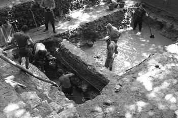
Once the appropriate size and location of the wet trench were determined, the wet trench was divided into two separate trenches, one large and the other small, separated by a narrow baulk (Fig. 21). Excavation would begin in this smaller trench. In addition to providing a preliminary assessment of submerged deposits and site stratigraphy, the small trench operated as a drainage trench or sump. Constant dewatering of the small trench served to drain the adjacent larger one (see Fasham Reference Fasham1984; Roskams Reference Roskams2001, 105–7; Puller Reference Puller2003, 11–68; Doran Reference Doran, Menotti and O'Sullivan2013, 484–8). Once the surface deposits of the large trench became dry, they would be excavated stratigraphically, as if on dryland. By fashioning a narrow opening in the baulk that stood between them to allow water to flow, and by always excavating and dewatering at a deeper level in the smaller trench, the project attempted to drain the larger trench as much as possible in order to excavate its deposits in dry conditions.
Excavation at the Basilica, Unit 21 (drainage trench on the left); RFE Project Excavations, 2012.

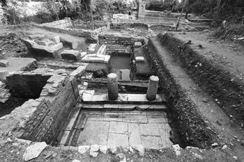
Problems with dewatering became the limiting factor to deep excavation at Butrint. The maximum depth achieved by the RFE Project occurred at the end of June 2012, at 7 m below the surface in the drainage trench within the Roman Basilica (Unit 21), at a little over 4 m below the water table at 3.12 RL (Reduced Level). At this depth, three water pumps, expelling water at a rate of about 2000 litres per minute, reached homeostasis with the incoming water. Deeper excavation became impossible because the amount of water pumped out of the trench was equal to the amount entering it. Similar homeostasis occurred in Unit 29 in 2013 at a slightly higher level at 3.35 RL (Fig. 22).
Pavement and columns in situ at the south-east corner of the Forum, showing drainage hose (background); Units 19 and 29, RFE Project Excavations 2013.

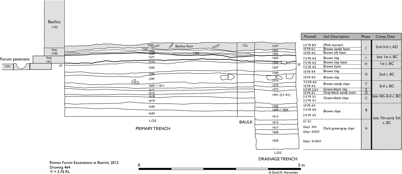
The RFE Project recovered important material evidence from the sequence of deposits below the floor of the Basilica in Unit 21 (Figs 7 and 23). The floor (1547) was made of thick, yellow, water-resistant mortar. The building was apparently thoroughly spoliated after its abandonment in the fifth century ad. The wet trench (3.5 × 7.3 m) was laid out inside the building. Part of the stratigraphy below the floor is illustrated in the south-facing section of the trench. The lowest deposit (1635) contained few and highly degraded remains of cultural material and was probably just above natural deposits of pre-habitation date. Sulphuric gas emissions became increasingly strong below c.5.00 RL, compelling archaeologists to work in shifts and nearly preventing deeper excavation. The gas indicates the presence of substantial underlying hydrocarbon deposits. One can only speculate whether the hydrocarbon deposits and sulphuric emissions played a role in the establishment of the Sanctuary of Asklepios at Butrint in the fourth century bc (Melfi Reference Melfi, Hansen and Hodges2007; Hernandez and Çondi Reference Hernandez, Çondi, Cabanes and Lamboley2010, 247–9).
Stratigraphy below the Basilica floor (south-facing section), Unit 21.

The main stratigraphic sequence encompasses 10 major phases (A–J), with ceramics dating from the late seventh century bc to the early third century ad. No architecture or remains of buildings were encountered within this sequence. A compact surface (above 1574) marks the truncation and working level (1608) for the construction of the first Forum step (1541) and Basilica. A levelling fill (1563, 1571) behind the step dates to the late first century bc, confirming a date in the Augustan period for the Forum's construction (Hernandez Reference Hernandezin press d). A truncation interface (1458) above the fill represents the reconstruction phase of the Basilica in opus mixtum in the late second or early third century ad. The reconstruction included the replacement of the Forum's second step (1540), which also was to serve as a foundation for the front wall (1193) of the remodelled Basilica. The deposits (1560, 1561, 1562, 1565, 1566, 1568) behind the top step show activities of working, filling and levelling prior to the laying of the mortar floor (1547).
More than half of the cultural deposits in the lower city are waterlogged, representing material culture dating from the origins of the city in the second half of the seventh century bc through to its life under the Roman Empire. The deepest deposits have yielded evidence not only for the earliest urban phases of Butrint, but also for the formation processes of the Butrint headland (Hernandez Reference Hernandezin press c). This can be shown from the evidence of seashell and wood remains. Seashells in the archaeological record can serve as a valuable indicator of relative sea level and the historical connectivity of a site to the sea (Pirazzoli Reference Pirazzoli1996, 25, 34–5, 53–4; Flemming Reference Flemming1979; Karali Reference Karali and Bar-Yosef Mayer2005; Dincauze Reference Dincauze2000, 434–43; Delamotte and Vardala-Theodorou Reference Delamotte and Vardala-Theodorou2008; Veropoulidou Reference Veropoulidou, Touchais, Laffineur and Rougemont2014; Krahtopoulou and Veropoulidou Reference Krahtopoulou and Veropoulidouin press). The types and quantities of seashells in deposits furnish information about the formation of deposits, environmental conditions, the relative timeframe of a deposit's submergence, and the historical use of shellfish at Butrint. Wood and other organic remains, such as leather, hair, and seeds, also provide insight into the formation of deposits and the submergence of the site, owing to their relatively rapid decay in dry conditions.
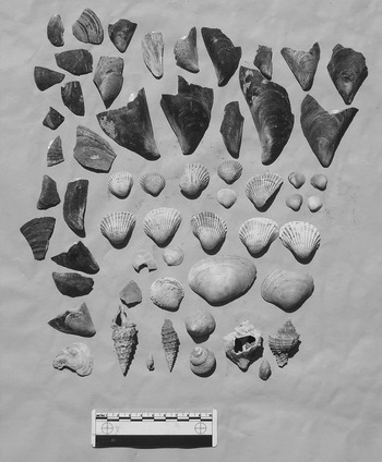
Although a detailed analysis of the material remains and stratigraphy is beyond the scope of this article, the evidence from mollusc and wood remains is sufficiently clear to show the relationship between sea level and urbanism at Butrint. All deposits from phases A–F contained large numbers of seashells from 10 of the 14 types identified by the RFE Project in ancient Butrint (Fig. 24). The most common are cockles (cerastoderma sp.), carpet shells (venerupis sp.; venus verrucosa), sea snails (cerithium sp.) and mussels (mytilus sp.). Less common, but consistently present, are the murex (hexaplex trunculus) and pink oyster (spondylus sp.). These molluscs are endemic to the subtidal and intertidal marine zone (for a contextual analysis of an archaeomalacological assemblage from the Vrina plain at Butrint, see Veropoulidou Reference Veropoulidou and Greensladein press). Mussels in particular flourish in intertidal regions, especially in rocky coastal environments, and are not naturally found in subtidal habitats. Most of the others lived submerged in shallow water, in a sandy, muddy and gravelly environment. The taphonomic conditions of the shells show no signs of sun exposure. There is no evidence that any of the shells were worked or pried open. The variability in their sizes also demonstrates that they developed in their natural habitat and were not harvested. Moreover, abundant fragments of natural wood, mostly small branches and twigs, and in some instances worked wood, were recovered only from these same deposits from phases A–F (Fig. 25). It is noteworthy that mollusc and wood remains are absent in all deposits above 1602/1611 and 1572 in Unit 21.
Molluscs from Context 1617, Unit 21.

Wood from Context 1617, Unit 2.

This evidence demonstrates that all deposits from phases A–F were at some point inundated by the sea, which allowed for mollusc colonisation and for the preservation of wood remains. Deposits in phases A and B were part of an ancient coast from the seventh to fourth centuries bc, located directly below the area that later became the Agora and Roman Forum (Hernandez Reference Hernandezin press c). A short strip of land near the foot of the Acropolis emerged in the third century bc as dryland. Four fragments of a plough, including its share, were recovered from these deposits, indicating agricultural use of the land, rather than public use as an agora (Fig. 8). This coastal strip, nevertheless, became inundated and tied to the sea in the same century. The lower city of Butrint did not become dryland and an urban centre until the second half of the second century bc.
CONCLUSIONS
The history of the water table lies at the heart of understanding the archaeology of Butrint. The water table effectively served as a barrier, acting against the colonialist and nationalist archaeological agendas of Italian fascist and Albanian communist archaeologists at Butrint. Archaeologists perceived all material on site above sea level as available for research. All material below sea level was situated beyond the horizon of their methodological approaches. The discovery of the submerged pavement slabs of the Roman Forum in 2005 is a testament not only to the historical limitations of archaeological methodology at Butrint, but also to the environmental forces that silently act upon the archaeologist in constructing the archaeological record.
The Aeneid is the only surviving ancient literary source to feature scenes of the city populated with people, monuments and topographical details. Ugolini used it as a lens to peer into the past. Viewing the excavations at Butrint as a counterpart to Schliemann's at Troy, he sought archaeological material at the site to validate the history of Rome's greatest epic, as he believed Schliemann had done for Greece's. There was a strong element of nationalism in his endeavour. As an Italian intellectual who believed in the historicity of Aeneas, Ugolini was essentially investigating, in his view, the founder of the Roman and Italian people. His research furthered the cause of Italian fascism, during which he rose to the highest echelon of academia. Italian fascism, promising a renewed age of imperial supremacy, claimed the legacy of ancient Rome and looked to Augustus for inspiration. With the approach of Augustus’ bimillennial birthday in 1937, the Augustan colony of Butrint was showcased as an example of Italy's contribution to ‘civilisation’, adding a positive message to the colonial aspirations of Mussolini's Italy.
Albanian excavations after the Second World War were driven by new ideological and political objectives, chief among which was the investigation of the ancient Illyrians, the purported ancestors of the Albanian people. Under communist rule, archaeological research in Albania was called upon to provide material evidence for the cultural continuity of Illyrians with modern Albanians and for the autochthonous formation of the Albanian people. The aim was to solidify the national identity of the young Albanian nation and heighten the cultural pride of its citizens. Budina, a Soviet-trained archaeologist, searched for Illyrians at Butrint. A methodological pattern is discernible from his archaeological excavations at Butrint. Avoiding groundwater, Budina excavated trenches on high ground and exposed ancient monuments down to the level of the water table. He chose to invest his energy and resources elsewhere, namely at the Hellenistic hilltop city of Antigonea, where pre-Roman (in his view, Illyrian) material can be retrieved directly below topsoil. From the 1960s to 1980s, Budina selected Antigonea for excavation because he considered it a much better site to search for the Illyrians than Butrint.
With the establishment of the Butrint Foundation after the end of communism, Hodges implemented an academically robust and well-funded programme of archaeological research that transformed not only archaeology at Butrint but also the practice and conception of archaeology in Albania. Hodges’ principal research aim was to study the city's Late Antique and Medieval phases, which had been marginalised in previous work at the site. The excavations of the Baptistery, Triconch, Diaporit, and Vrina plain from 1994 to 2008 were circumscribed by the water table, which served as the limit of excavation. When the Butrint Foundation excavations began in 1994, the primary scholarship on Butrint was Ugolini's writings, since Budina and other archaeologists left much of their research at Butrint unpublished. It is possible that Ugolini's expressed frustrations with groundwater influenced the outlook of Butrint's subsequent excavators who came to view groundwater similarly, as both a limit of excavation and an enemy to archaeological research. This serves as a cautionary tale illustrating how the published accounts of previous archaeologists can influence present methodological perspectives on fieldwork.
Recognising the inextricable relationship between historical sea level and urbanism at Butrint, the RFE Project examined the wet-site archaeology of the lower city. This included, in addition to waterlogged deposits, the history of the water table and the site's stratigraphy. The project developed methods to excavate effectively below the water table, using a system of drainage trenches and water pumps. Traces of the city's origins on the Acropolis in the second half of the seventh century bc were recovered from deep deposits in the ancient urban centre. It was found that more than half of the cultural deposits in the lower city of Butrint are waterlogged. This material represents one of the richest sources of archaeological evidence at Butrint. The waterlogged deposits preserve organic remains extremely well, including wood, hair, leather, textiles and seeds. The analysis of mollusc and wood remains collected systematically during excavation reveals that a strip of land near the foot of the Acropolis emerged as dryland in the third century bc. The discovery of a plough suggests that the land was first used for agriculture. This period was short lived, however, and this coastal land became submerged in the same century. The formation of the lower city of Butrint occurred in the second century bc. It is in the later part of this century that the lower city became dryland and an urban centre. The evidence for the changing position of the shoreline and for the rise in relative sea levels shatters present conceptions of Butrint from Archaic to Hellenistic times and calls for a comprehensive reappraisal of pre-Roman Butrint.
Groundwater kept the Greek, Epeirote and Roman archaeology of the lower city untouched by the destructive forces of nature (oxidation) and the ambitions of colonial and nationalist archaeologists. The water table has been a powerful agent at Butrint, not only driving the city's development in antiquity and decline in the modern period, but also shaping the conception and execution of archaeological research at the site. It was the inexorable trend of rising water levels over the past three thousand years, which its inhabitants were constantly confronting, that shaped the city. Battling water at Butrint has represented a struggle in the longue durée, impacting urbanism and the fate of the city, as well as the actions of its ancient inhabitants and its modern archaeologists alike.
ACKNOWLEDGEMENTS
I am indebted to the Loeb Classical Library Foundation, the American Council of Learned Societies and the Woodrow Wilson National Fellowship Foundation for the fellowship awards that permitted me to write this article. The RFE Project has benefited tremendously from the unwavering support and assistance of Richard Hodges, President of the American University of Rome, to whom I owe a heavy debt for all of his help and guidance over the years. I thank the RFE Project co-director, Dhimitër Çondi, for his tireless efforts to ensure the success of the project. I am indebted to numerous individuals and institutions for their invaluable support. Funding for the RFE Project was generously provided by the University of Notre Dame (Office of the Vice President for Research; Institute for Scholarship in the Liberal Arts; Department of Classics), the Packard Humanities Institute, the American Philosophical Society and the Butrint Foundation. I am grateful to the entire faculty in the Department of Classics at the University of Notre Dame and to Jack L. Davis and Charles Brian Rose for their support. On behalf of the RFE Project, I thank the directors of the Albanian Institute of Archaeology, Luan Përzhita and Shpresa Gjongecaj, as well as the Albanian Ministry of Culture for granting the project permission to excavate at Butrint. I am grateful to the two anonymous referees for their helpful comments and suggestions to improve this article. Finally, I wish to thank all archaeologists, specialists, students and local excavators, for their contributions to the RFE Project.