1. INTRODUCTION
The combined use of GPS and GLONASS has attracted increasing interest recently amongst the navigation community due to the steady progress in the revitalization of the GLONASS system. Although a complete constellation was initially planned to be realized by the year 2012, the system is expected to reach its full operational capability by the end of 2009 as a result of accelerated pace for the restoration of the Russian GLONASS system (Petrovski et al., Reference Petrovski, Engelsberg and Babakov2008). Currently GLONASS is already in the phase of modernization. So far sixteen GLONASS-M satellites have been put in orbit. The next generation GLONASS-K satellites will start to launch in 2010 or 2011. A newer satellite, GLONASS-KM, is anticipated to begin launching after 2012 (Revnivykh, Reference Revnivykh2008). It can be expected that a considerable number of navigation users will use the combined GPS/GLONASS equipments in the near future.
Combined GPS/GLONASS navigation can offer many advantages for navigation users, such as enhanced availability, improved accuracy and integrity. Very often the navigation users are in environments with limited satellite visibility such as in urban or mountainous areas. In such situations the navigation users will significantly benefit from the combined use of GPS and GLONASS. However, the number of GPS and GLONASS satellites that can be observed is often still insufficient to derive a position solution partly because an additional unknown has to be solved due to the system time difference between GPS and GLONASS (STDGG). As a result, a fifth satellite is required to obtain a navigation solution.
The GLONASS system has adopted an independent system time maintained by the GLONASS Central Synchronizer by means of a set of hydrogen masters (ICD-GLONASS, 2002). The difference between GPS and GLONASS system times will cause a bias between the GPS and GLONASS pseudo-range measurements in combined GPS/GLONASS receivers (Bauch et al., Reference Bauch, Piester, Moudrak and Petit2004). This problem can be solved either at the user or system level. At the user level, the STDGG can be estimated as an additional unknown parameter in the user navigation solution by processing combined GPS and GLONASS measurements. At the system level, STDGG can be determined and distributed to users through the satellite navigation message. The former requires at least five measurements to estimate three position coordinates, a receiver clock offset and a STDGG and has been widely applied in the GPS/GLONASS receivers (Moudrak et al., Reference Moudrak, Konovaltsev, Furthner, Hammesfahr, Bauch, Defraigne, Bedrich and Schroth2005). The latter requires the availability of the system time difference data between GPS and GLONASS. Although the Russian authorities have proposed to include the STDGG in the GLONASS-M navigation message (Langley, Reference Langley1997), this information has not been available to date. But even if the GPS-GLONASS system time offset is broadcast via the navigation data, an additional unknown parameter is still necessary due to the existence of inter-system hardware delay bias.
In this paper, an algorithm has been proposed which is able to support combined GPS/GLONASS navigation with a minimum of four GPS and GLONASS satellites and is independent of the availability of STDGG from the navigation message. The method provides a novel solution to further improve the accuracy and particularly the availability of combined GPS/GLONASS navigation solutions in poor satellite visibility conditions.
2. STANDARD POSITIONING MODEL
In combined GPS/GLONASS navigation, one additional unknown parameter has to be solved due to the difference between GPS and GLONASS system times. This difference may be interpreted as the offset between the GPS receiver clock and the GLONASS receiver clock (Habrich, Reference Habrich1999).
According to ICD-GLONASS, the GLONASS time is generated on a base of GLONASS Central Synchronizer (CS) time by means of a set of hydrogen clocks. The GLONASS time is based on an atomic time scale UTC(SU) maintained by Russia with a difference of three integer hours and a fractional part less than 1 millisecond (ICD-GLONASS, 2002). On the other hand, the GPS time is established by the GPS Master Control Station and referenced to a UTC (USNO) maintained by the U.S. Naval Observatory. The GPS time differs from UTC (USNO) as the latter is corrected periodically with an integer number of leap seconds (ICD-GPS, 2000). Therefore, there is a difference of leap seconds between GPS and GLONASS times. The GLONASS time could be transformed into the GPS time using the following equation (Habrich, Reference Habrich1999 and Kang et al., Reference Kang, Lee, Park and Lee2002):

where τc=t UTC(SU)−t GLONASS; τu=t UTC−t UTC(SU); τg=t GPS−t UTC. The system time difference t GPS−t GLONASS is the sum of τc, τu and τg after the number of leap seconds is removed.
To determine STDGG, an unknown parameter associated with the STDGG could be estimated along with three position coordinates and a receiver clock offset. Alternatively two receiver clock offsets could be introduced with respect to GPS and GLONASS system times respectively whereas the STDGG becomes the difference between the two clock offsets.
In the following, the algorithm of combined GPS/GLONASS navigation is first described along with mathematical equations based on a standard positioning model currently adopted in most GPS/GLONASS receivers.
For a single-frequency GPS/GLONASS receiver, the pseudorange between a receiver and a satellite is described by:


where the superscript g and r denote a GPS and a GLONASS satellite, respectively; P is the measured pseudorange (m); ρ is the true geometric range (m); c is the speed of light (m/s); dt is the receiver clock offset (s); dt sys is the STDGG (s); dT is the satellite clock offset (s); d orb is the satellite orbit error (m); d trop is the tropospheric delay error (m); d ion is the ionospheric delay error (m); d mult is the multipath error (m); ε is the measurement noise (m).
The unknown parameters for the above model include three position coordinates, a receiver clock offset and a STDGG. The tropospheric delay error is corrected using Hopfield tropospheric model. Niell mapping functions are used for both dry and wet delays. The ionospheric delay is corrected by applying the Klobuchar ionospheric delay model. GPS and GLONASS broadcast ephemerides are used to calculate the satellites' positions and clock offsets. The GLONASS satellite coordinates in the PZ-90 coordinate system are transformed into WGS-84.
A linearized observation equation can be defined as:

where Δρ is the difference between the estimated and measured values; v is the error vector which includes the measurement noise, multipath as well as other residual errors. The explicit form of the H matrix and ΔX matrix is provided below:
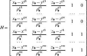

The covariance matrix of the measurements can be expressed by:
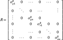
where σgi2 and σri2 are the variance of the i-th GPS or GLONASS satellite, respectively; N and m denote the number of measurements for GPS and GLONASS, respectively. As five unknown parameters need to be estimated, at least five satellites are required in order to obtain a position solution using a Weighted Least Square method.
3. STABILITY OF GPS-GLONASS SYSTEM TIME DIFFERENCE
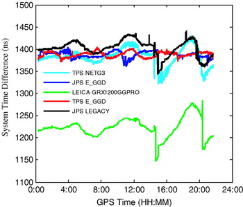
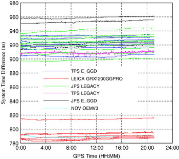
An important consideration in the handling of the system time difference parameter is its stability in time. To obtain a better understanding of its temporal variation characteristics, the short-term stability of the system time difference is investigated in this section. First of all, the standard positioning model is employed to estimate the system time difference. Shown in Figure 1 are the estimated epoch-by-epoch STDGG values using data from different types of receivers at five IGS (International GNSS Service) stations, namely WTZR, PARK, PENC, KHAJ and DLFT, on January 14, 2008. The results indicate that the estimated STDGG values vary within a range of 40ns most of the time during the day. The sudden drop at around 14:30 for TPS NETG3, JPS LEGACY and LEICA GRX1200GGPRO receivers is caused by the decrease of the visible GLONASS satellite number. The estimated STDGG values using this single point positioning (SPP) technique only have an accuracy of more than ten nanoseconds and therefore the curves in Figure 1 could not reflect truly the temporal variation of the system time difference. More accurate estimates of the system time difference could be obtained through the combined GPS and GLONASS precise point positioning (PPP) technique (Cai and Gao, Reference Cai and Gao2008). Figure 2 shows the estimated system time difference for 30 GNSS stations on June 11, 2008 using PPP technique. As can be seen, the estimates of the system time difference are very stable within one day. The difference in the estimated STDGG between different stations in both Figure 1 and Figure 2 is due to the existence of the inter-system hardware delays which are dependent on specific receivers.
Estimated system time difference for different receiver types with SPP.

Estimated system time difference for different receiver types with PPP.

4. A NAVIGATION ALGORITHM WITH A MINIMUM OF FOUR VISIBLE SATELLITES
If a priori known STDGG is available, the required minimum satellite number to derive a position solution can be reduced to four, instead of the five required by the standard positioning model. The accuracy of the estimated position will then depend on the accuracy of the a priori known STDGG value.
The linearized observation equation is rewritten as:

The a priori known STDGG can be treated as a quasi-observable and the corresponding design matrix can be expanded into the following form:
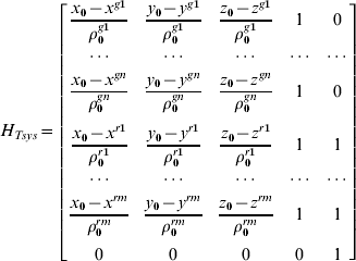
The unknown parameter vector ΔX is given below:

The corresponding covariance matrix of the measurements has the following expression (Vanschoenbeek et al., Reference Vanschoenbeek, Bonhoure, Boschetti and Legenne2007):
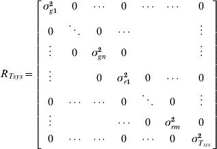
Where  is the variance of the a priori known STDGG. The navigation algorithm based on Equations (8)–(11) is referred to as a new positioning model which is different from the standard positioning model since it contains a priori STDGG information.
According to the previous section, the STDGG remains stable within one day. Therefore, the navigation users may determine STDGG at the user level using the standard positioning model when enough satellites are available. In conditions where only four GPS/GLONASS satellites are visible, the latest computed STDGG value can be used as a priori known information to determine the position using the new positioning model. Sometimes the satellite geometry could still be very poor even if more than four GPS/GLONASS satellites are visible. Using the latest estimated STDGG as a quasi-observable will contribute to improving the positioning accuracy.
5. IMPACT OF SYSTEM TIME DIFFERENCE ON POSITIONING ACCURACY
Before the new positioning model could be applied, the impact of the system time difference on positioning accuracy had to be assessed due to the use of a quasi-observable. To study the influence of the STDGG on the positioning accuracy, the epoch-by-epoch STDGG was first estimated based on all visible satellites using the standard positioning model. Afterwards an absolute error value of 0 ns, 15 ns, 30 ns and 45 ns was respectively introduced to the obtained STDGG estimates, which were then treated as a priori information to perform position determination using the new positioning model with different visible satellite numbers.
A GPS/GLONASS observation dataset, collected on January 14, 2008 at the IGS station KHAJ, was utilized for this study. The data sampling rate was 30s and the elevation mask was set to 10 degrees. KHAJ is equipped with a TPS E_GGD GPS/GLONASS receiver and a JPSREGANT_SD_E antenna. The PDOP mask was set to 15 during the entire processing.
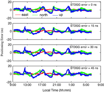
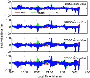
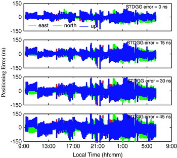
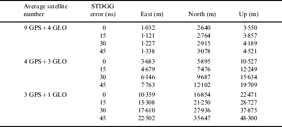
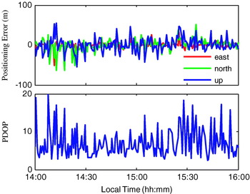
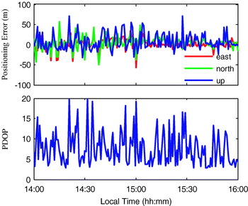
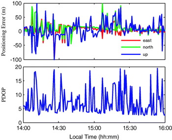
To analyze the impact of the STDGG on the positioning accuracy under different satellite visibility conditions, different numbers of visible satellites are simulated. Figures 3–5 show the comparisons of the positioning errors between different STDGG errors. In Figure 3, the observations from all visible satellites are used while in Figure 4 only measurements from the first tracked four GPS satellites and the first tracked three GLONASS satellites in each epoch are used. The positioning errors with only four GPS/GLONASS satellites are given in Figure 5 where the measurements from the first tracked three GPS satellites and first tracked one GLONASS satellite are used in the position solution. Table 1 shows the statistical results of the positioning errors for different STDGG errors and different visible satellite numbers. These results show an influence of the accuracy of the a priori known STDGG on the position solution.
Impact of system time difference on positioning accuracy with all visible satellites.

Impact of system time difference on positioning accuracy with average seven satellites.

Impact of system time difference on positioning accuracy with four satellites.

RMS statistics of the positioning accuracy for different STDGG errors.
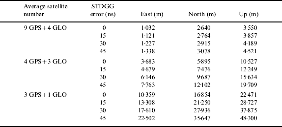
It is clear that the estimated position accuracy will degrade if the accuracy of the a priori known STDGG decreases. The results also show that the fewer the visible satellites are used for a position solution, the greater is the impact of the STDGG error on the positioning solution. But it is interesting to notice that even with an error of 45ns in STDGG, a positioning accuracy of 42m (1-sigma) in the horizontal plane is still obtainable with three GPS satellites and one GLONASS satellite. This provides a basis to apply the navigation algorithm proposed in Section 4 to make combined GPS/GLONASS navigation possible with only four visible satellites.
6. POSITIONING ACCURACY WITH FOUR GPS/GLONASS SATELLITES
To assess the performance of the proposed algorithm for the combined GPS/GLONASS navigation with four GPS/GLONASS satellites, numerical computations were conducted. The observation dataset on January 14, 2008 from KHAJ station and a dataset collected on February 11, 2008 in downtown Calgary were utilized for the performance analysis.
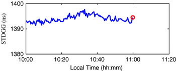
The epoch-by-epoch STDGG from 10:00 to 11:00 at KHAJ station was first determined using the standard positioning model. The STDGG value at 11:00, as can be seen from the red circle in Figure 6, was used as a priori known value in the following position estimation.
Estimated system time difference at KHAJ station.

The dataset from local time 14:00 to 16:00 was processed with the new positioning model for the analysis of the positioning accuracy. The following four scenarios have been assessed:
• four GPS only satellites
• three GPS satellites and one GLONASS satellite
• two GPS satellites and two GLONASS satellites
• one GPS satellite and three GLONASS satellites
Due to the a priori known STDGG, only four GPS/GLONASS satellites are required to obtain a position solution. For each scenario, the GPS and GLONASS observations to be used were taken randomly from all available GPS and GLONASS observations in each epoch, respectively. Since the satellite geometry is usually poor when only four satellites are visible, the PDOP mask is therefore set to 20 so that the positioning accuracy could be assessed more reasonably.
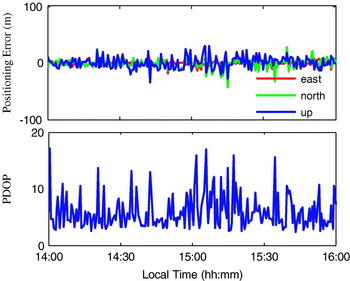
Shown in Figures 7–10 are the positioning errors and the corresponding PDOP values for the four scenarios. Table 2 provides a statistics of the positioning accuracy. The position accuracy degrades if more GLONASS observations are used in the navigation solution. This is partly because of the lower accuracy of the GLONASS satellite orbit and clock data. Further, the a priori known STDGG being considered as a quasi-observable also has an impact on the positioning accuracy. The more the GLONASS observations are used, the greater is the impact on the positioning accuracy. However, even for the worst case with one visible GPS satellite and three visible GLONASS satellites, the positioning accuracy of around 30 m (1-sigma) in the horizontal and vertical planes are still considered useful in some navigation applications such as land navigation, in which a horizontal positioning accuracy of 100 metres is usually adequate (Garmin, 2005). Since land navigation users often operate in mountainous areas, the proposed positioning algorithm enables position determination even with four GPS/GLONASS satellites which will contribute to increasing the availability of position solutions.
Positioning errors with four GPS only satellites.

Positioning errors with three GPS satellites and one GLONASS satellite.

Positioning errors with two GPS satellites and two GLONASS satellites.

Positioning errors with one GPS satellite and three GLONASS satellites.

RMS statistics of positioning results (m).

It is important to keep in mind that the positioning accuracy given in Table 2 is obtained with a PDOP mask of 20 whereas a much smaller PDOP mask is usually adopted in current GPS/GLONASS receivers. If the threshold is set to a smaller value, the positioning accuracy will be higher than the results presented due to its dependence on PDOP. But a lower PDOP setting will also decrease the availability of position solutions in limited satellite visibility environment. Therefore there is a trade-off between the positioning accuracy and the availability of position solutions.
To further evaluate the proposed algorithm for navigation with limited satellite visibility, an experiment was conducted using a Javad Legacy GPS/GLONASS receiver and antenna in downtown Calgary on February 11, 2008. An 1800-epoch dataset was collected with a 1s sampling interval. A 10 degrees elevation mask was used. When only four GPS/GLONASS satellites were visible, the latest computed STDGG was utilized to support the position determination using the new positioning model. PDOP mask was set to 20. Figure 11 shows the environment in the test site where the dataset was collected. Although more than four GPS satellites and one GLONASS were visible most of the time, the PDOP value was greater than the PDOP mask at the first fifteen minutes so that few navigation positions were obtained, which can be seen from Figure 12. In the area between the two pink lines, only three GPS satellites and one GLONASS satellite were visible during this period of time. To determine the positions during this period, the last computed STDGG is used as a priori known value in the new positioning model. The positioning errors are also shown in Figure 12, and the corresponding error statistics are provided in Table 3. As can be seen, the positioning accuracy with four satellites is just slightly lower than the positioning results with more than four satellites. The horizontal positioning accuracy of approximate 16m (1-sigma) is obtained when only three GPS satellites and one GLONASS satellite are available in this experiment.
GPS/GLONASS data collection in downtown Calgary.

Processing results in downtown Calgary.

RMS Statistics of position results (m).

7. CONCLUSIONS
Based on the research results presented in this paper, the difference between the GPS and GLONASS system times remains stable within one day and the accuracy of the system time difference also does not have a severe impact on the positioning results using combined GPS and GLONASS observations. This finding has led to the development of a new algorithm to derive a position solution even in conditions with only four visible GPS/GLONASS satellites. Based on the new algorithm, the system time difference can be determined at the user level when sufficient visible satellites are available. When only four GPS/GLONASS satellites are visible or the satellite geometry become worse, the latest computed system time difference value can be used to determine a valid position.
Numerical computations have been conducted using a dataset from the IGS station KHAJ, and the results have been applied to evaluate the proposed solution for combined GPS and GLONASS navigation. The positioning accuracy with four GPS/GLONASS satellites is lower than the accuracy with four GPS satellites. In the case of four GPS/GLONASS satellites, the more GLONASS measurements are used, the lower is the positioning accuracy. This is due to the lower accuracy of the GLONASS broadcast orbit and clock data and the influence of the error in the latest estimated system time difference as a quasi-observable. A field experiment has also been conducted in downtown Calgary. The results indicate that the positioning accuracy with four GPS/GLONASS satellites is only slightly worse than the positioning accuracy with more than four visible satellites.
Based on the numerical computation results, a horizontal positioning accuracy of 10–30 m (1-sigma) is attainable with a PDOP mask 20 in the case of four visible GPS/GLONASS satellites. The proposed combined GPS/GLONASS positioning algorithm enables position determination even with four visible satellites which can improve the availability of position solutions for navigation users who operate in a limited satellite visibility environment.
ACKNOWLEDGMENTS
The financial supports from NSERC and GEOIDE and the contribution of data from the International GNSS Service (IGS) and Information-Analytical Center (IAC) are greatly appreciated. The experiment support from the Department of Geomatics Engineering at the University of Calgary is also gratefully acknowledged.
Based on a paper presented at The Institute of Navigation International Technical Meeting, Savannah, Georgia, September 2008.