

INTRODUCTION: FROM MIDDLE TO UPPER PALAEOLITHIC
The change from Middle to Upper Palaeolithic and the concomitant change from Neanderthal to anatomically modern humans has long exercised prehistorians and continues to do so, as witnessed by a number of recent broad surveys on the subject (Allsworth-Jones Reference Allsworth-Jones2014; Higham et al. Reference Higham, Douka, Wood, Bronk Ramsey, Brock, Basell, Camps, Arrizabalaga, Baena, Barroso-Ruíz, Bergman, Boitard, Boscato, Caparrós, Conard, Draily, Froment, Galván, Gambassini, Garcia-Moreno, Grimaldi, Haesaerts, Holt, Iriarte-Chiapusso, Jelinek, Jordá Pardo, Maíllo-Fernández, Marom, Maroto, Menéndez, Metz, Morin, Moroni, Negrino, Panagopoulou, Peresani, Pirson, Rasilla, de la, Riel-Salvatore, Ronchitelli, Santamaria, Semal, Slimak, Soler, Soler, Villaluenga, Pinhasi and Jacobi2014; Davies et al. Reference Davies, White, Lewis and Stringer2015; Hublin Reference Hublin2015; Sánchez-Quinto & Lalueza-Fox Reference Sánchez-Quinto and Lalueza-Fox2015). In some respects our perspective on this matter has altered drastically, most notably in connection with improved dating methods. Radiocarbon dating of bone and charcoal using ultrafiltration and an acid-base-oxidation: stepped combustion (ABOx-SC) protocol, respectively, has produced a succession of results which are markedly older than those previously obtained, particularly when taken in conjunction with an improved calibration curve (IntCal09 or later) now extending back for some 50,000 years (Higham Reference Higham2011; Bird et al. Reference Bird, Ayliffe, Fifield, Turney, Cresswell, Barrows and David1999). Also important are methods completely independent of radiocarbon dating, such as Thermo-luminescence (TL) and tephrochronology, employing both macro- and micro-tephra to provide a ‘tephra lattice’ of ‘ash time lines’ (isochrons) extending over very wide areas of the European continent.
The way in which these changes have affected our perceptions can be illustrated by reference to the site of Kostenki 14 in Russia. Here the Campanian Ignimbrite (arising from an explosion at the Phlegrean Fields in Italy) is clearly visible, with a date estimated at 39.3 kyr on the basis of Ar/Ar measurements (Pyle et al. Reference Pyle, Ricketts, Margari, Andel, van, Sinitsyn, Praslov and Lisitsyn2006). Charcoal from this horizon, with a previously younger age, has been re-dated using the ABOx-SC procedure to 35,080±249BP which, when calibrated, comes to 40,990–39,340 calBP (Douka et al. Reference Douka, Higham and Sinitsyn2010). Consistent with this are three further ABOx-SC dates on charcoal from archaeological layer IVa beneath the Campanian Ignimbrite (Wood et al. Reference Wood, Douka, Boscato, Haesaerts, Sinitsyn and Higham2012). Moreover, an Early Upper Palaeolithic industry occurring before, in, and after the Campanian Ignimbrite horizon has been classified as Proto-Aurignacian on the basis of such artefacts as Dufour bladelets (Hoffecker et al. Reference Hoffecker, Holliday, Anikovich, Sinitsyn, Popov, Lisitsyn, Levkovskaya, Pospelova, Forman and Giaccio2008, fig. 6). A skeleton found in 1954, in a burial pit cut down through the volcanic ash layer and always recognised as anatomically modern human, has now been dated to 33,250±500BP (equivalent to a calibrated age of 38,800–36,900 calBP) (Marom et al. Reference Marom, McCullagh, Higham, Sinitsyn and Hedges2012) and Sinitsyn (Reference Sinitsyn2013) has suggested that its association with the Proto-Aurignacian seems now ‘most probable’. By contrast, the Neanderthals in the Caucasus, once suggested to be relatively recent, have retreated into the past. At Mezmaiskaya, a Neanderthal neonate skeleton from layer 3 was originally dated to 29,195±965BP, but now infant cranial fragments from the overlying layer 2 have been dated (using ultrafiltration) to 39,700±1100BP, equivalent to 45,600–42,300 calBP (Pinhasi et al. Reference Pinhasi, Higham, Golovanova and Doronichev2011).
Results not dissimilar to these have also been reported from central and south-eastern Europe, in the first place from Geissenklösterle, Germany. Relying on new ultrafiltrated radiocarbon results, Higham et al. (Reference Higham, Basell, Jacobi, Wood, Bronk Ramsey and Conard2012) conclude that the Early Aurignacian in layer III can be bracketed within the time range 43,060–41,480 calBP. This is in agreement with a mean TL date for this layer of 40,200±1500BP (Richter et al. Reference Richter, Weiblinger, Rink and Wagner2000), whereas the underlying Mousterian layer VII has an estimated radiocarbon age of 48,600±3200BP. At Willendorf II, Germany, re-examination of the archaeological material and new excavations conducted since 2006 have established that the Early Aurignacian in layer III (lithological horizon C8-3) can be bracketed by ABOx-SC dated samples in the horizons above and below (C8-2: 39,000±500 versus D1 top 43,200±900BP) to a period equivalent to about 46,000–43,000 calBP (Nigst et al. Reference Nigst, Haesaerts, Damblon, Frank-Fellner, Mallol, Viola, Götzinger, Niven, Trnka and Hublin2014). Four radiocarbon (ultrafiltrated) dates on bone artefacts from the Aurignacian occupation of Peskő cave in the Bükk mountains of Hungary have been obtained, of which the oldest is on a non-split-based bone point dated to 38,300±1500BP (44,604–40,684 calBP; Davies et al. Reference Davies, White, Lewis and Stringer2015, table 8a). With these results may be compared those now available from the cave of Kozarnika in north-west Bulgaria, where an industry defined as equivalent to the Proto-Aurignacian in layer VII has produced four radiocarbon dates in the range from 39,310 to 36,200BP, equivalent to a calibrated range of 43,400–41,300 calBP (Tsanova Reference Tsanova2008; Hublin Reference Hublin2015). Further results can be expected soon to add to this picture (Hopkins et al. Reference Hopkins, Sirakov, Guadelli, Hromadová, Markó and Higham2016).
As noted, the dates for the Middle Palaeolithic and associated Neanderthal remains at Geissenklösterle and Mezmaiskaya are also much older than hitherto assumed, bearing out the validity of the warning given by Mellars (Reference Mellars2006) that the ‘long tail’ of more recent dates for them in Europe was likely to be severely tested. The Neanderthal range has been confirmed to extend to Central Asia (Teshik-Tash) and to Siberia (Okladnikov and Denisova caves), where genetic evidence indicates that the proportion of Neanderthal-derived DNA in present-day populations outside Africa generally amounts to 1.5–2.1% (Krause et al. Reference Krause, Orlando, Serre, Viola, Prüfer, Richards, Hublin, Hänni, Derevianko and Pääbo2007; Green et al. Reference Green, Krause, Briggs, Marcic, Stenzel, Kircher, Patterson, Li, Zhai, Fritz, Hansen, Durand, Malaspinas, Jensen, Marques-Bonet, Alkan, Prüfer, Meyer, Burbano, Good, Schultz, Aximu-Petri, Butthof, Höber, Höffner and Siegemund2010; Prüfer et al. Reference Prüfer, Racimo, Patterson, Jay, Sankararaman, Sawyer, Heinze, Renaud, Sudmant, Filippo, de, Li, Mallick, Dannemann, Fu, Kircher, Kuhlwilm, Lachmann, Meyer, Ongyerth, Siebauer, Theunert, Tandon, Moorjani, Pickrell, Mullikin, Vohr, Green, Hellmann, Johnson, Blanche, Cann, Kitzman, Shendure, Eichler, Lein, Bakken, Golovanova, Doronichev, Shunkov, Derevianko, Viola, Slatkin, Reich, Kelso and Pääbo2014, 45). So far as Europe is concerned, the related Denisovan ‘sister group’ did not make any such contribution (Krause et al. Reference Krause, Fu, Good, Viola, Shunkov, Derevianko and Pääbo2010a; Reich et al. Reference Reich, Green, Kircher, Krause, Patterson, Durand, Viola, Briggs, Stenzel, Johnson, Maricic, Good, Marques-Bonet, Alkan, Fu, Mallick, Li, Meyer, Eichler, Stoneking, Richards, Talamo, Shunkov, Derevianko, Hublin, Kelso, Slatkin and Pääbo2010, fig. 3; Meyer et al. Reference Meyer, Kircher, Gansauge, Li, Racimo, Mallick, Schraiber, Jay, Prüfer, Filippo, Sudmant, Alkan, Fu, Do, Rohland, Tandon, Siebauer, Green, Bryc, Briggs, Stenzel, Dabney, Shendure, Kitzman, Hammer, Shunkov, Derevianko, Patterson, Andrés, Eichler, Slatkin, Reich, Kelso and Pääbo2012; Prüfer et al. Reference Prüfer, Racimo, Patterson, Jay, Sankararaman, Sawyer, Heinze, Renaud, Sudmant, Filippo, de, Li, Mallick, Dannemann, Fu, Kircher, Kuhlwilm, Lachmann, Meyer, Ongyerth, Siebauer, Theunert, Tandon, Moorjani, Pickrell, Mullikin, Vohr, Green, Hellmann, Johnson, Blanche, Cann, Kitzman, Shendure, Eichler, Lein, Bakken, Golovanova, Doronichev, Shunkov, Derevianko, Viola, Slatkin, Reich, Kelso and Pääbo2014, fig. 8), but certain early modern humans did have a higher than average percentage of Neanderthal-derived DNA. This applies to Peştera cu Oase and Kostenki 14, as well as to Ust’-Ishim in Siberia (Trinkaus et al. Reference Trinkaus, Moldovan, Milota, Bîlgăr, Sarcina, Athreya, Bailey, Rodrigo, Mircea, Higham, Bronk Ramsey and Plicht2003; Rougier et al. Reference Rougier, Milota, Rodrigo, Gherase, Sarcină, Moldovan, Zilhão, Constantin, Franciscus, Zollikofer, Ponce de León and Trinkaus2007; Fu et al. Reference Fu, Li, Moorjani, Jay, Slepchenko, Bondarev, Johnson, Aximu-Petri, Prüfer, Filippo, de, Meyer, Zwyns, Salazar-García, Kuzmin, Keates, Kosintsev, Razhev, Richards, Peristov, Lachmann, Douka, Higham, Slatkin, Hublin, Reich, Kelso, Viola and Pääbo2014; Reference Fu, Hajdinjak, Moldovan, Constantin, Mallick, Skoglund, Patterson, Rohland, Lazaridis, Nickel, Viola, Prüfer, Meyer, Kelso, Reich and Pääbo2015; Krause et al. Reference Krause, Briggs, Kircher, Maricic, Zwyns, Derevianko and Pääbo2010b; Seguin-Orlando et al. Reference Seguin-Orlando, Korneliussen, Sikora, Malaspinas, Manica, Moltke, Albrechtsen, Ko, Margaryan, Moiseyev, Goebel, Westaway, Lambert, Khartanovich, Wall, Nigst, Foley, Lahr, Nielsen, Orlando and Willerslev2014). The remains at Peştera cu Oase consist of a mandible and cranium, the first with an estimated date of 34,950+990/−890BP, equivalent to 40,440±1030 calBP, but it must be remembered that there was no associated archaeological material. The femur from Ust’-Ishim has two dates of c. 41,400BP corresponding to 46,880–43,210 calBP, but here again there was no direct archaeological context. While these results show a degree of inter-connectedness between Neanderthals and early modern humans, in general it seems, on the basis of recent genetic studies, that the Neanderthals had a small long-term population size, with isolated groups probably practising inbreeding at times, and that these characteristics could have played a role in their extinction (Sánchez-Quinto & Lalueza-Fox Reference Sánchez-Quinto and Lalueza-Fox2015). The early moderns did not share these characteristics, so there is still a marked contrast between the two.
So-called ‘transitional’ lithic industries, as the name implies, have long been identified as providing some kind of link between the Middle and Upper Palaeolithic in Europe and elsewhere. One that has been studied with particular care is the Bohunician, named after the type site in Brno, Czech Republic (Valoch Reference Valoch1976). New excavations at this locality were undertaken in 2002, as a result of which we now have a reliable TL date of 48,200±1900BP (Richter et al. Reference Richter, Tostevin and Škrdla2008). The Aurignacian is not represented at the site, but at Stránská skála (7 km east of Bohunice) it is stratified above the Bohunician. The single archaeological layer at Bohunice includes bifacial leafpoints, Levallois points, end scrapers, and burins, as well as side scrapers, and technological elements such as blade cores and crested blades (ibid., fig. 2). Svoboda (Reference Svoboda2007) refers to this industry as ‘Levallois-leptolithic’, where blanks of Levallois character were obtained by a variety of non-Levallois reduction methods. This characterisation reinforces the detailed attribute analysis carried out by Tostevin, but it should be noted that the latter author did not believe that this ‘particular technological style (contributed) to the subsequent Upper Palaeolithic industries of Central and Eastern Europe’ (Tostevin Reference Tostevin2000, 104).
Bohunice is a good reference point because it has both an unambiguous stratigraphy and an industry which can be clearly defined. If these advantages are lacking, it can be quite difficult to determine what exactly is a ‘transitional’ industry. Such an industry was claimed to exist in locality II layer VI at Temnata Dupka in northern Bulgaria, but Tsanova’s careful re-analysis shows that colluvial processes operating on the slope at this point are highly likely to have conflated two separate assemblages (Tsanova Reference Tsanova2008, fig. II.15). There was no single homogeneous industry, nor evidence of an evolution of one into the other (ibid., 78, 102). At Bacho Kiro, also in northern Bulgaria, the industry in layer 11 was originally defined by the excavators as an early form of Aurignacian (Kozłowski Reference Kozłowski1982). Here Tsanova (Reference Tsanova2008, chap. I) claims that we may really have to do with a ‘transitional’ industry, but the difficulty in this case relates not so much to the stratigraphy as to the nature of the industry itself. As she clearly indicates, much of the initial working of the raw material was carried out prior to its transport to the site, and what we have left was subject to considerable use and re-use (redébitage). There are only 15 cores and 319 reliably identified tools, as distinct from the 667 claimed by the original investigators (ibid., tables I.3 & I.6). The author lays emphasis on the appearance of Mousterian points, previously regarded as simply retouched blades, and also on the presence of Levallois flakes (ibid., figs I.19–20 & I.11) but because of breakage and re-use it is difficult to be too sure of the latter.
The situation at Temnata Dupka locality I layer 4 is more satisfactory, both as regards the stratigraphy and the nature of the industry. There are three subdivisions (phases A–C) of layer 4, but Tsanova gives good reasons for thinking that there are no great differences between them (Tsanova Reference Tsanova2008, 158–9). There are more than 10,000 artefacts all told, with indications that all stages of manufacture were carried out on the spot. The industry is defined as ‘transitional’ on the basis of 49 cores and 215 tools (rather than 455 as originally suggested) (ibid., tables II.17 & II.22). The cores witness a ‘technological passage’ from more Levallois type forms to more volumetric ones (ibid., 157, fig. II.62.2 and 3) and there are some triangular flakes which are said to be similar to Levallois débitage products (ibid.,150, fig. II.68). There are three uncalibrated radiocarbon dates in the range of 39,100–38,200BP, as well as a TL date of 45±7 kyr, for phase B at the site.
Partly to avoid the ambiguity inherent in the traditional term, there is a tendency now to refer to ‘transitional’ industries as Initial Upper Palaeolithic (Hublin Reference Hublin2015; Zwyns et al. Reference Zwyns, Rybin, Hublin and Derevianko2012), forming an integral part of what has been termed a ‘mosaic pattern of cultural heterogeneity’ existing prior to the time of the Campanian Ignimbrite (Davies et al. Reference Davies, White, Lewis and Stringer2015, fig. 5; Hublin Reference Hublin2015, fig. 7). This aspect is of particular relevance in the present context, since the cave of Brînzeni has been hitherto best known in the literature as a representative of a ‘transitional’ industry in Moldova.
RESEARCH PROJECT IN MOLDOVA: BRÎNZENI CAVE
In 1992–1993 a programme supported by the British Academy and the McDonald Institute for Archaeological Research was initiated, a primary objective of which was to obtain samples for dating at the Oxford Radiocarbon Laboratory, from three countries, Moldova, Ukraine, and Russia, with particular reference to the early Upper Palaeolithic and the late Middle Palaeolithic in those countries. Forty-four radiocarbon dates from ten sites, and the results of the programme as a whole, have been published (Hedges et al. Reference Hedges, Housley, Pettitt, Bronk Ramsey and Klinken1996; Allsworth-Jones Reference Allsworth-Jones2000). So far as Moldova is concerned, a full account of the work done at Ciuntu has also been published (Borziac et al. Reference Borziac, Allsworth-Jones, French, Medyanik, Rink and Lee1997). Unfortunately the same does not apply to Brînzeni and Buzdujeni, the other two sites investigated in Moldova, despite the fact that, as stated in the report on Ciuntu, the results from that site did to some extent ‘throw into doubt the real existence’ of the Brînzeni culture. The objective of this report is to remedy that omission in respect of Brînzeni, not only by documenting the work done at that time and arising directly from it, but by reconsidering all the evidence available for the site as recorded before and since.
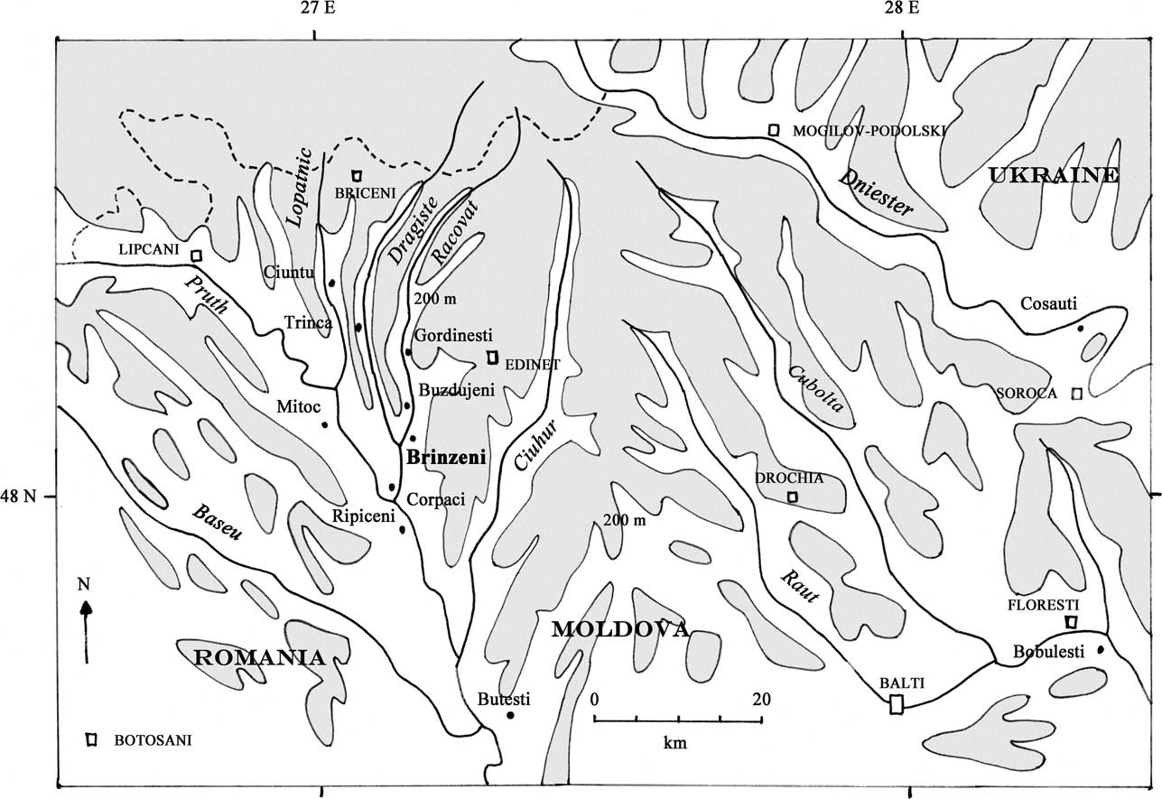
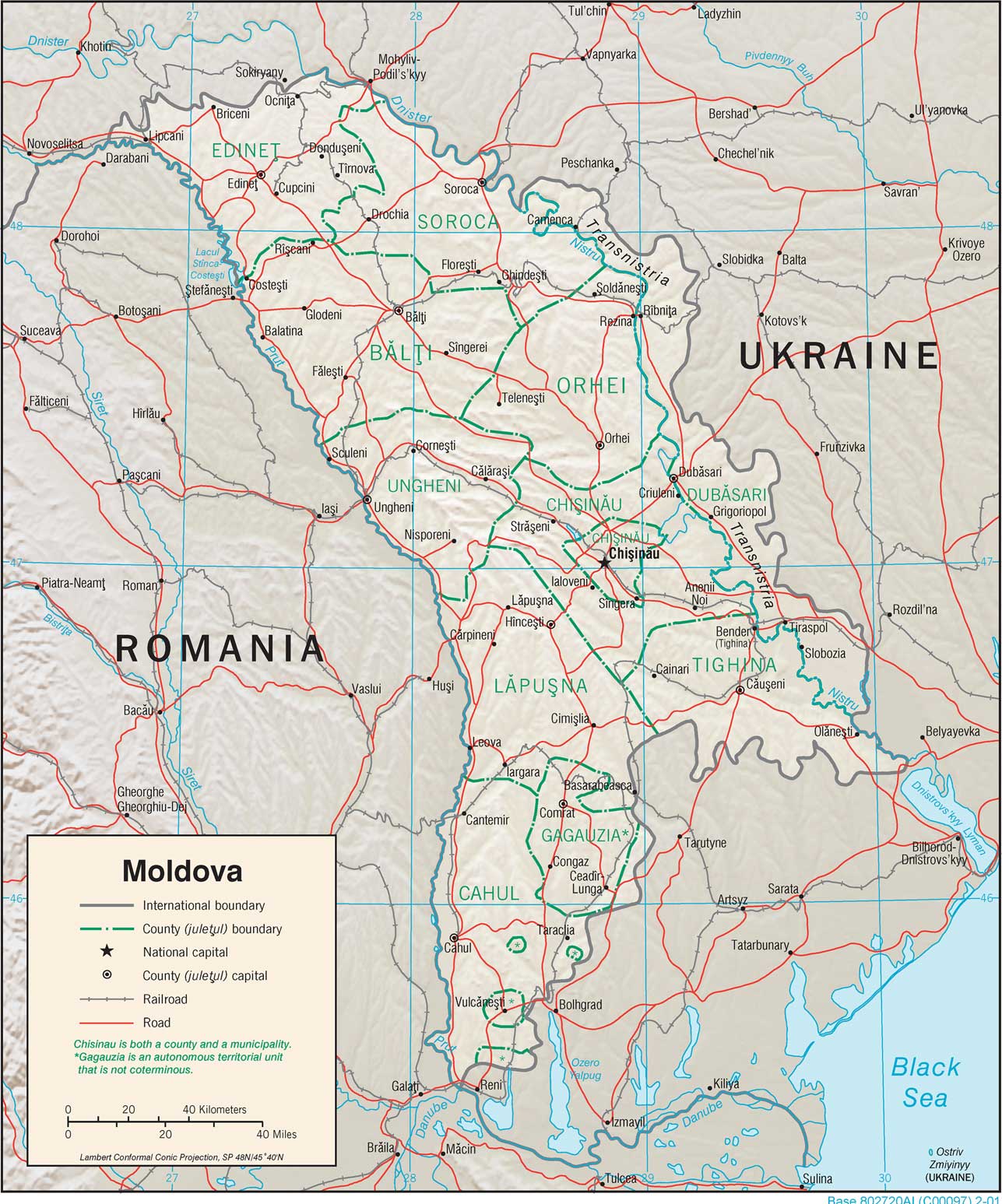
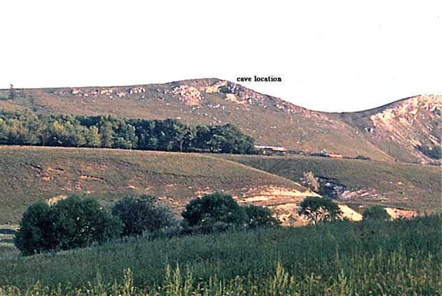
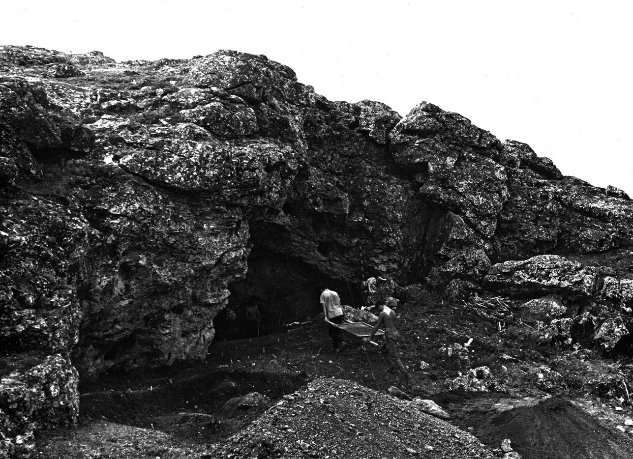
The archaeological site of Brînzeni was discovered by N.A. Chetraru and V.N. Verina in 1960, and was first published by Chetraru in 1973 (Chetraru Reference Chetraru1973; Verina Reference Verina1980). It is situated 1.5 km south-west of the village of Brînzeni in the Edineţ region of north-western Moldova, its approximate geographical coordinates being 48° 05’ N and 27° 15’ E. Its position, together with that of a number of other Palaeolithic sites, is indicated in Figure 1, and the situation of Moldova within south-eastern Europe as a whole is shown in Figure 2. The region is sometimes referred to as a kind of mini-Dordogne on account of the many occupied caves situated in adjacent river valleys in a relatively restricted area; valleys that (as shown on the map) are separated from each other by narrow ridges rising above 200 m in height. The cave known strictly speaking as Brînzeni I faces north-north-west, near the top of one of these karstic limestone ridges on the eastern bank of the river Racovăț, about 62 m above the present course of the river, and 8 km from its confluence with the Pruth (Fig. 3). The ridge was a reef in Miocene times, one of a number of such formations known as Toltry. Originally the cave will have been larger, but the dripline has receded, such that its present dimensions are about 9×18 m. The roof varies in height from about 0.5 m to 4 m. Before the beginning of the excavations, the surface of the cave including the terrace was uneven, with several fallen limestone blocks. The surface was slightly inclined, at an angle of 3–5° to the north, ie, towards the valley. Beneath the terrace, the land slopes away quite steeply, and it is considered that in the past it was probably quite difficult to enter the cave except from the side.
Map of north-western Moldova showing position of Palaeolithic sites

Situation of Moldova within south-eastern Europe

General view of Brînzeni cave above the river Racovăț

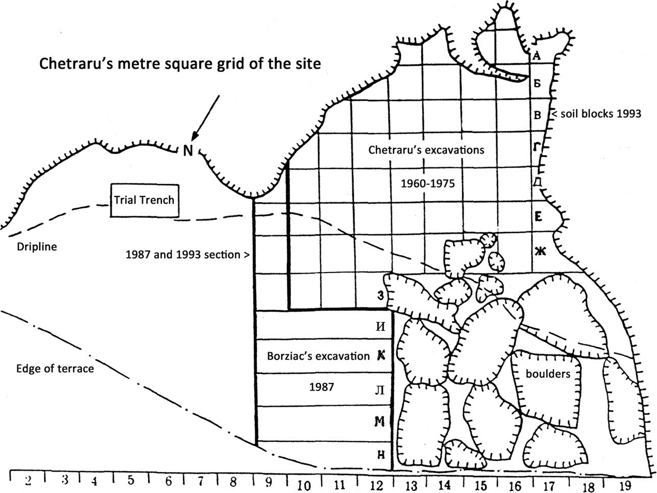
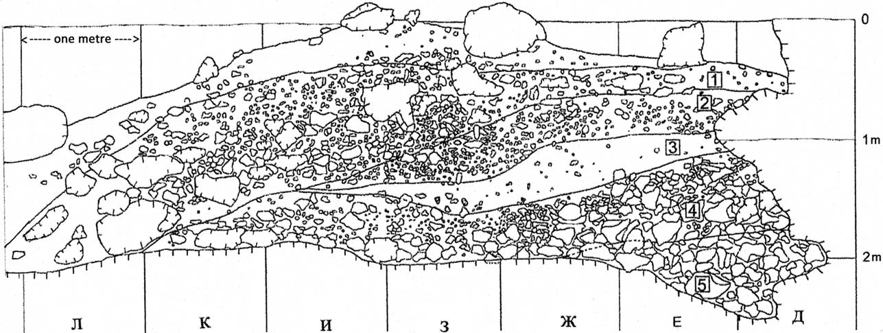
In the year the site was discovered, Chetraru carried out an initial excavation in the form of two trial trenches, each 2×1 m in size, the first in the central part of the cave, the second on the eastern side practically on the terrace. Figure 4 presents a plan of the site showing the excavated squares. It should be noted that here and elsewhere the original numbering plus Cyrillic lettering system for the site has been retained. Chetraru conducted further excavations in 1963, 1964–5, 1968, and 1975. The total area he excavated was about 60 m2 in the south-western portion of the site, mainly beneath the roof overhang (Fig. 5). In 1987, I.A. Borziac extended the excavated area to the north-east by 22 m2, establishing an intact sequence running from the interior out on to the terrace for 8 m. This area is indicated separately on Figure 4. The profile which he established, running along the 8–9 line, is the most detailed which has hitherto been available and is shown in Figure 6. The maximum thickness of deposit did not exceed 2 m. In 1993, part of Borziac’s section on the same line was cleaned and re-examined and samples were taken for dating and other purposes, as described in this report. Quite a large portion of the site on the north-western part of the terrace (which is covered by large boulders) remains unexcavated, as does a further portion on the east. The layer numberings and descriptions given by Chetraru and Borziac (and also by A.I. David, M.N. Grishchenko, and S. I. Medyanik) differ in detail – though not in their fundamentals – and it therefore seems sensble to treat them separately.
Plan of Brînzeni cave showing the grid coordinates employed

Chetraru’s excavations in progress 1963

Brînzeni drawn section on the 8–9 line 1987 (after Chirica et al. Reference Chirica, Borziac and Chetraru1996, fig. 13)

Chetraru’s excavations 1960–1975
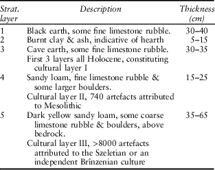
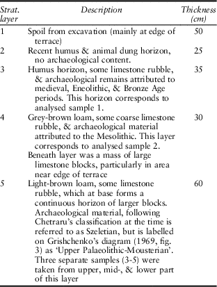
The stratigraphy established by Chetraru was first described by him in terms of five layers, the upper three of which correspond to the Holocene (Chetraru Reference Chetraru1973, 70). It seems that the first two layers did not produce artefacts, whereas the third contained material attributed to medieval times, as well as the Eneolithic and Bronze Age, constituting cultural layer I. This version is reflected in Grishchenko’s account (see below), although the first two layers (beneath the spoil heap) are amalgamated into one (Grishchenko Reference Grishchenko1969, 136). The fact that this layer (or two layers) existed plays quite an important role in his interpretation of the site. The version given later (Chirica et al. Reference Chirica, Borziac and Chetraru1996, 14) differs somewhat from this, in that the uppermost layer is equated with cultural layer I, and this version is repeated by Noiret (Reference Noiret2009, 79–80). Layers 4 and 5 (with cultural layers II and III) are the same in both accounts. Chetraru’s first version (1973, 69–73), with minor corrections, is shown in Table 1.
chetraru’s description of the stratigraphy at brînzeni (chetraru Reference Chetraru1973, 69–70)

Borziac’s excavation 1987
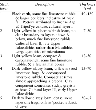
The stratigraphic section described by Borziac is in the north-eastern part of the site, running from the back of the cave to the edge of the terrace in a south-east to north-west direction (Fig. 6, see also Chirica et al. Reference Chirica, Borziac and Chetraru1996, fig. 13; Noiret Reference Noiret2009, fig. 37). Beneath fill from the former excavations, the layers are described as in Table 2 (Chirica et al. Reference Chirica, Borziac and Chetraru1996, 14–15).
borziac’s description of the stratigraphy at brînzeni (chirica et al. Reference Chirica, Borziac and Chetraru1996, 14–15)

Apart from the fact that there is only one Holocene layer in this section, Borziac draws attention to two other ways in which it differs from the sequence described by Chetraru, ie, the presence of layers here labelled 3 and 5. Layer 3 contained no archaeological material, but it served as a reliable reference point for dividing layers 2 and 4. Layer 5 is said to have contained two flint artefacts of ‘rather archaic character’. As is clear from the drawn section, a clear sequence was established, for the most part in the back of the cave under the roof overhang. Nearer to the dripline and beyond, the layers were deformed, in places they merged, and they wedged out all together where the terrace began to slope away.
Borziac comments that in layer 1 the artefacts were found in various positions and did not constitute a real cultural horizon. It is considered that most of them were derived from the plateau above the cave, where there was a Tripol’ye settlement. In layer 2, both in Chetraru’s excavations and those of 1987, the artefacts and associated faunal remains were found in a thin lens near the walls of the cave. They represent traces of what is described as a temporary occupation, dating in Borziac’s view to the end of the Upper Palaeolithic. By contrast, the archaeological material in layer 4 was found in practically all parts of the site and constitutes a substantial cultural layer. The faunal remains, as well as the flint and sandstone artefacts, lay in different positions and were unevenly distributed over the excavated area. It was observed in 1987 that some of the bones occurred vertically, and this was taken as an indication of some disturbance. There were relatively more finds in the central part of the cave excavated by Chetraru than on the terrace, and they tended to be concentrated in the lower rather than the upper part of the deposits. In Borziac’s opinion, however, neither his own excavations nor those of Chetraru gave any reason to doubt the layer’s homogeneity. He draws attention to the fact that at the base of the layer excavated by Chetraru, in square Г13, the ashy remains of a small hearth were discovered. It consisted of a patch of burnt ground more or less round in form and 350–450 mm in diameter, with a thickness varying between 9 mm and 43 mm. Some stones were positioned around the hearth. Elsewhere some burnt bones and flints were observed, as well as traces of ash and charcoal, and these probably represent the remains of further hearths.
Medyanik’s samples for palynological analysis were taken from Borziac’s section in 1987, hence her numbering of the layers follows his system, and the position of the samples within the layers is indicated in her diagram (see Fig. 13). David’s analysis of the fauna, both from Chetraru’s and Borziac’s excavations, was carried out in terms of cultural layers II and III, hence the two sets analysed are identical in terms of provenance.
Re-examination of the stratigraphy 1993
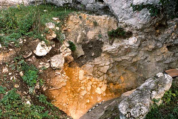
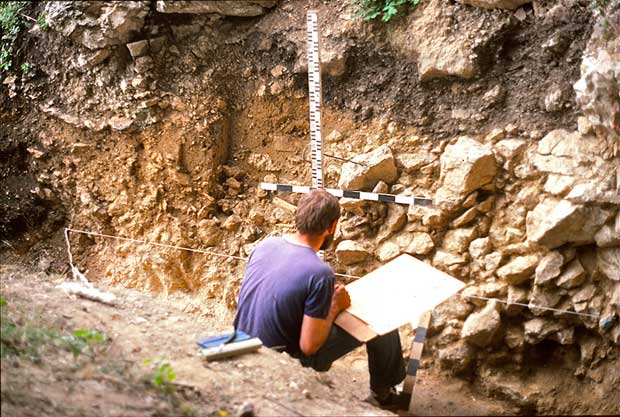
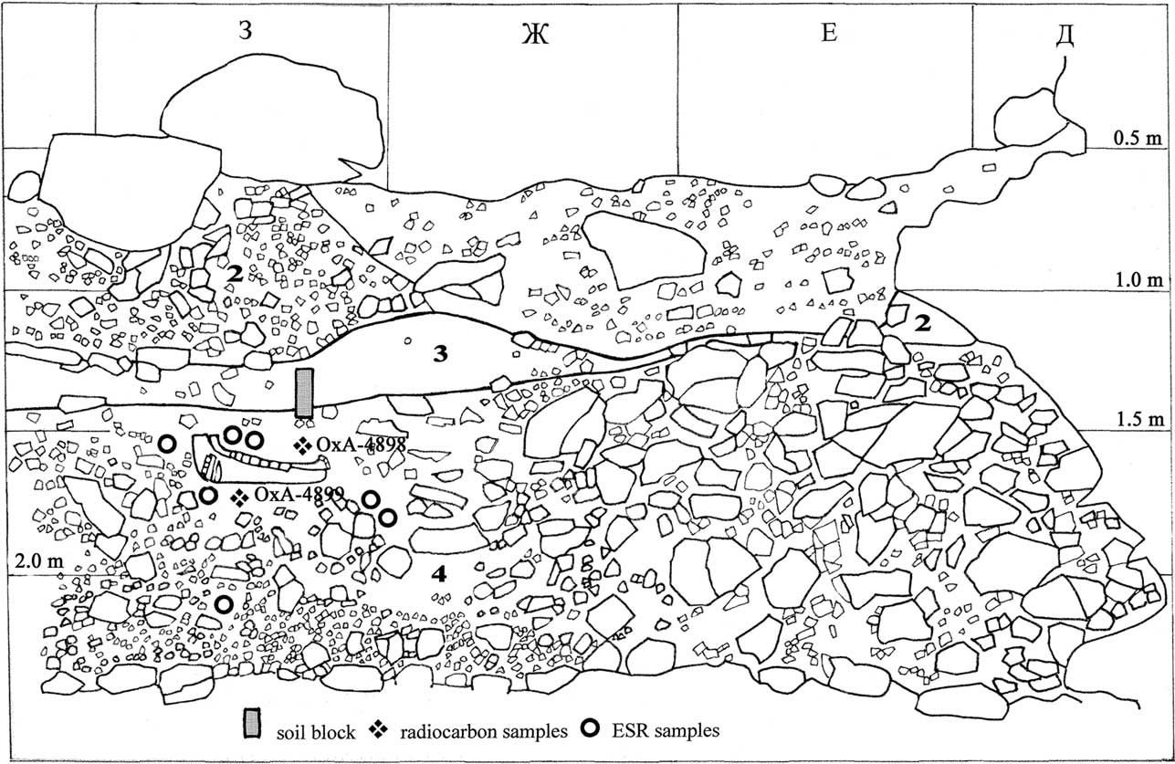
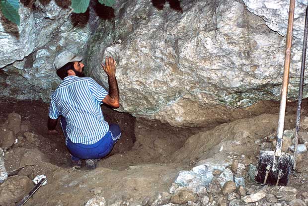
Over seven days in the period 28 July–30 August 1993, Borziac’s section along the line 8–9 was re-examined and samples were taken. The work was directed by Ilie Borziac, with the assistance of Sergei Covalenco, and with the participation of Nicolae Chetraru. Already on 2 July 1992 five samples for radiocarbon dating had been taken from square E15 in the interior of the cave, from intact deposits at the base of the area excavated by Chetraru. The section established in 1993, as drawn by Covalenco (Figs 7–9), extends for a length of about 4.5 m embracing the squares Д, Е, Ж, and З, from the back of the cave to the outer part of the terrace. As indicated in Figure 6, the lettered squares correspond to 1 m each. In order to determine the stratigraphic delimitation of the layers, the section had to be cut back to some extent, hence in horizontal plan some of the finds are recorded as being present in line 8. Since the main centre of interest was cultural layer III, principal attention was devoted to this, and the remainder of the section was cleared only insofar as was necessary for the safe conduct of the work. As Borziac remarked, the situation revealed was essentially the same as that recorded in 1987, but differed in detail, particularly in the upper part of the deposits. At the top of the sequence, there was a considerable thickness of rubble, most of it constituting fill from the former excavations, which we did not seek to differentiate from the observed brown remnants of stratigraphic layer 1 (7.5 YR 4/3). A large amount of stony material on the outer part of the terrace was attributed to stratigraphic layer 2, whereas a small wedge of dark brown material (7.5 YR 3/2) under the rock overhang represented a remnant of cultural layer II. Beneath, a significant layer of light yellowish brown (10 YR 5/6–6/4) relatively stone-free material was observed, which wedged out from the terrace towards the interior. This in Covalenco’s opinion could most suitably be classified as stratigraphic layer 2/3, although it is clearly the equivalent of the layer classified simply as 3 in Borziac’s excavation of 1987. Stratigraphic layer 4 (cultural layer III) was most fully revealed in squares З and Ж, where it attained a thickness of about 0.70 m. The matrix was yellowish brown (10 YR 5/4) to very pale brown (10 YR 7/3), but it was packed with stones, practically constituting a breccia, as Borziac remarked in 1987 (Chirica et al. 1996, 14–15). He also commented on the general dampness of these deposits. In the opinion of Constantin Mihailescu, who was present for some of the time at the site, any loess component in this layer could well have been blown in from the north-west. At the very base, thicker towards the outer part of the terrace, there was a horizon of fine white (10 YR 8/1) rubble, above bedrock. Towards the interior of the cave, there was a mass of large stones, corresponding stratigraphically to Borziac’s layer 5.
Brînzeni section on the 8–9 line work in progress 1993

Brînzeni section on the 8–9 line work in progress 1993

Brînzeni section on the 8–9 line 1993 (as drawn by S. Covalenco)

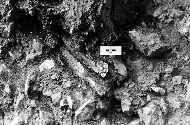
Cultural layer III contained a large quantity of animal bones and teeth, as well as flint artefacts in close association with them. Most noticeably, the remains of a well preserved horse mandible were unearthed in square З8 at a depth of about 1.50–1.68 m (all measurements being calculated by reference to the datum point established in 1987). The maximum length of the horse mandible as recovered was about 0.47 m, constituting – as our excavation crew exclaimed – a virtual ‘Percheron’ (a breed of cart horse) (Fig. 10). Artefacts found in the immediate vicinity included a Levallois point and three burins, one dihedral and two on breaks. Two samples for radiocarbon dating were taken in immediate proximity to the horse mandible, as indicated on the section profile. Also shown are the positions where samples were taken for ESR dating. It was possible to obtain a soil block for micromorphological study at the intersection of stratigraphic layers 3 and 4 (the latter equivalent to cultural layer III) but not lower down at this location because of its excessively stony character. Fortunately there was an opportunity to remedy this situation in the interior of the cave, since as already mentioned there were intact deposits at the base of the area excavated by Chetraru. Two further soil blocks from this layer (which as on the terrace contained abundant archaeological material) were accordingly obtained by the wall of the cave in square B17 at a maximum depth of 2.16 m (Fig. 11). The nature of the deposits in square E15, where radiocarbon samples had been obtained in 1992, was also further examined.
Horse mandible recovered in square З8 in cultural layer III

Work in progress to recover the soil blocks in square B17 in cultural layer III

Geological and micromorphological analysis of the cave deposits
As mentioned above, an analysis of the geological conditions at the site was carried out by M.N. Grishchenko in 1965, published briefly in 1969, but in greater detail in an unpublished report in 1966. Following our work at the site in 1993, two of the soil blocks were analysed by Charles French, with a contribution by L-P. Zhou concerning the magnetic susceptibility analysis. The results are reported here for the first time.
GEOLOGICAL EVALUATION 1965
In 1965 M.N. Grishchenko visited Brînzeni (along with two other sites in the area) in order to evaluate their stratigraphy from a geological point of view. At Brînzeni, as he pointed out, quite a lot of material had already been removed from the interior of the cave. He established a profile along the edge of Chetraru’s trench running from the back of the cave to the terrace; it was not numbered, but it will have corresponded to one of Chetraru’s lines, such as 14–15, Б–Е. The thickness of deposits at that point varied between 1.8 and 1.5 m. The layers essentially were as defined by Chetraru, but their numbering, thickness, and characterisation as shown by Grishchenko (Reference Grishchenko1969, 136 & fig. 3) was somewhat distinct, as shown in Table 3.
grishchenko’s description of the stratigraphy at brînzeni (grishchenko Reference Grishchenko1969, 136 & fig. 3)

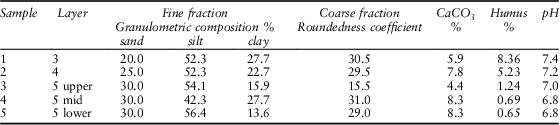
More details concerning the deposits were given in his unpublished report (Grishchenko Reference Grishchenko1966), where five samples were analysed, as in Table 4. The numbers given in this report were used in the diagrams accompanying Grishchenko’s published account (1969, figs 2 & 3). As shown in Table 4, the sediments were analysed in terms of the granulometric composition of the fine fraction, the roundedness of the coarse fraction expressed as a coefficient (the basis for the calculation of which unfortunately was not explained), as well as CaCO3 and humus content, and pH values. The samples were analysed in terms of the given characteristics, as follows, from the base of the sequence upwards.
sedimentological study of the deposits at brînzeni (after grishchenko Reference Grishchenko1966)

Fine fraction
In terms of their relative proportions of sand, silt, and clay, the samples essentially fall into two or three categories (well separated in the triangular diagram in Grishchenko Reference Grishchenko1969, fig. 2): 1, 2, and 4 are classed as ‘heavy silty’ loams on account of their relatively high clay content, whereas 3 and 5 are classed as ‘medium silty’ loams, with reduced clay content. Clay peaks occur in samples 1 and 4, but 4 is also somewhat distinct from 1 and 2, because of its relatively low silt content, thanks to which it stands by itself in the triangular diagram.
Coarse fraction roundedness and calcium carbonate content
Grishchenko pointed out that these two measurements tended to vary in the same way, although there was something of a second dip in CaCO3 content in sample 1. The figures for sample 3, ie, the upper part of layer 5, are particularly significant. The increase in coarse fraction roundedness at this point signifies an increase in chemical as distinct from physical weathering, and is consistent with a decrease in calcium carbonate content through leaching. Climatically this is interpreted as an increase in temperature and humidity, and is linked to the rock fall horizon which seals large parts of layer 5. In Grishchenko’s view, this rock fall brought occupation of the cave to a halt and it lay exposed to the elements for a considerable period, marking a clear hiatus between the end of layer 5 and the commencement of layer 4. By contrast, cold and dry conditions with intensive frost weathering and exfoliation of material from the walls of the cave both preceded and succeeded this episode.
Humus content and pH value
These measurements also tend to vary together, with a regular increase from base to top. In Grishchenko’s view, both reflect the existence of an animal dung horizon in layer 2. It is known that in recent times, before the commencement of the excavations, the cave was used for herding sheep and goats.
In general, therefore, a tripartite division of layer 5 (corresponding to cultural layer III) is suggested, with signs of significant chemical weathering in the upper part and a probable hiatus before sedimentation at the site resumed. Presumably the rock fall at the top of layer 5 corresponds approximately to the light yellow loam layer recognised by Borziac on the terrace (his stratigraphic layer 3). Cold and dry conditions with intensive frost weathering were otherwise characteristic of the site, including layer 4 (corresponding to cultural layer II).
MICROMORPHOLOGICAL ANALYSIS 1993
The application of soil micromorphology (Bullock et al. Reference Bullock, Fedoroff, Jongerius, Stoops and Tursina1985; Courty et al. Reference Courty, Goldberg and Macphail1989; Murphy Reference Murphy1986) is of considerable significance since, apart from Grishchenko’s work mentioned above, little geological or sedimentological investigation has been carried out at Brînzeni, or indeed at any other cave site in the region. The technique aims to provide detailed insights into the composition and derivation of the occupation and/or natural deposits, and the formation processes involved (Goldberg & Macphail Reference Goldberg and Macphail2006, 170ff).
Method
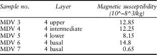
The intact block sediment samples brought from the site were impregnated and made into thin sections, using the methodology of Murphy (Reference Murphy1986). They have been described using the terminology of Bullock et al. (Reference Bullock, Fedoroff, Jongerius, Stoops and Tursina1985) and Stoops (Reference Stoops2003). Detailed micromorphological descriptions are found in the Appendix, and a summary of the results is provided in Table 5. In addition, all the sediment blocks prior to impregnation were scanned using a magnetic susceptibility meter by Dr L-P. Zhou, in order to identify any possible soil and/or occupation surfaces, and sub-samples were also taken for laboratory analysis. The results are summarised in Table 6.
micromorphological results for brînzeni

magnetic susceptibility results for brînzeni

The samples
Three soil blocks were taken from the site, one across the layer 3/4 interface in square З8 in the 1993 section (Fig. 9), and two from layer 4 in square B17 in the interior of the cave. Layer 3 is described as a light yellow to whitish loam with some fine, sharp-edged limestone rubble. Layer 2 above included numerous micro-faunal remains believed to be indicative of owl pellets, corresponding to cultural layer II. The underlying layer 4 is described as a dark yellow loam, containing some animal bones, corresponding to cultural layer III.
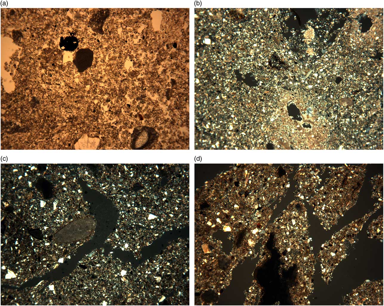
The thin section across the layer 3/4 interface was essentially all one fabric, but it exhibited two distinct types of structure. The upper 25 mm of the slide (layer 3) exhibited a moderately well developed, small, sub-angular blocky ped structure, whereas the lower 110 mm of the slide (layer 4) was apedal, homogeneous, and massive in nature. The fabric is dominated by very fine quartz (30%) and micro-sparitic calcium carbonate (40%), with minor amounts of silt (<8%) and fragments of clay (<15%) (Fig. 12, a & b). The whole fabric is very weakly phosphatised. As minor additions, there are a very few sub-rounded aggregates of calcium carbonate, as well as discontinuous to continuous infills of void space with micritic to amorphous calcium carbonate and discontinuous aggregates of fine fabric, a few irregular zones of manganese cementation, and sesquioxide nodules. Very fine (<50–100μm) fragments of clay occur throughout the groundmass, consisting of laminated and non-laminated pure and dusty clays.
a: Photomicrograph of the dense, ‘dirty’, very fine sandy/silt loam fabric, sample 3/4 (frame width 4.5 mm; plane polarised light); b: Photomicrograph of the calcitic very fine sandy/silt loam fabric with continuous to discontinuous void fills, sample 3/4 (frame width 4.5 mm; plane polarised light); c: Photomicrograph of fine sandy loam, sample 4/1 (frame width 4.5 mm; cross polarised light); d: Photomicrograph of the irregular aggregated fabric, sample 4/1 (frame width 2.25 mm; cross polarised light)

One of the soil blocks from layer 4 in the interior of the cave was analysed. This layer was similar in composition to the lower part of layer 3/4 on the terrace described above, and is a calcitic, very fine to fine sandy silt loam (Fig. 12, c). Nonetheless, it does exhibit discontinuous horizontal laminations, varying in thickness from 0.5–5 mm. Within each ‘bedding zone’, the groundmass is further organised into small, sub-rounded to irregular aggregates of 1–10 mm (Fig. 12, d). The whole fabric is very weakly phosphatised.
Magnetic susceptibility analysis
A series of spot samples for magnetic susceptibility analysis were taken from the sediment blocks prior to impregnation for micromorphological analysis, and from small bulk samples taken from each layer. All the laboratory readings were low, and none suggested that any real soil formation occurred, nor were land surfaces present.
Interpretation
The base of layer 3 (in sample 3/4) exhibits a small blocky ped structure defined by channels, but there were no evident signs of included cultural material. This structure is most probably a consequence of several freeze-thaw cycles (Van Vliet-Lanoe Reference Van Vliet-Lanoe2010, 84). Subsequently, this horizon was subject to considerable secondary wetting with calcium and iron-rich water and subsequent drying. This is most probably the result of water percolating through the soil from within the cave.
The top of layer 4 in the layer 3/4 interface sample is a homogeneous calcitic very fine sand. This is suggestive of a loessic sediment subject to secondary neo-calcitic formation and much mixing through bioturbation. This observation confirms Mihailescu’s comment at the time concerning the presence of a loess component.
The whole of the layer 3/4 interface is weakly phosphatised, indicative of severe surface weathering and perhaps also animals frequenting the cave. In addition, the surface of some of the bones is ‘pock-marked’ or etched, which suggests that there has been a weakly acidic environment present at some point.
Layer 4, in the interior of the cave, although it is comprised of a similar fabric to the above sample, exhibits discontinuous and aggregated material that was once horizontally bedded. This may indicate the accumulation of successive episodes of wind-blown material by water action, which has then become subject to a combination of frost-heave, continuing percolation with water, and much bioturbation.
Conclusions
The micromorphological results from this site, as well as the other Moldovan sites examined, were remarkably consistent. At Brînzeni, the whole sequence in layers 3 and 4 is essentially composed of water-lain, loessic-like sediments. The lower part of layer 3 exhibits a blocky ped structure which is probably indicative of frost-thaw cycles. Layer 4 is much affected by disturbance through bioturbation and freeze-thaw activity. The whole sequence has suffered alternate wetting and drying and the secondary formation of calcium carbonate throughout the fabric. These processes imply that the cave deposits were subject to much within-soil/sediment percolation by water.
As at Ciuntu (Borziac et al. Reference Borziac, Allsworth-Jones, French, Medyanik, Rink and Lee1997), there is a distinct lack of any observable cultural layer or midden-type debris which could represent human use of the cave. There is also little in the way of secondary pseudomorphs of included plant material. This could be because much of it has been subject to oxidation, mixing processes, and destruction in the past. The minute, generally phosphatised, faunal remains found to a greater or lesser extent in all layers indicate the amount of surface physical weathering, disturbance by wind/water, and comminution by freeze-thaw and soil fauna, as well as mixing processes, to which they have been subject.
Palynological analysis and interpretation
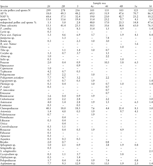
This analysis was carried out by S.I. Medyanik, on the basis of Borziac’s excavations of 1987, using the stratigraphic layer denominations determined by him. A total of nine samples were analysed using standard methods. In all samples apart from 2a pollen and spores were found in sufficient numbers (103–299) to permit analysis.
Apart from pollen and spores in situ, quite large numbers of redeposited specimens were found in all samples, including Tsuga, Sciadopitys, Morus, Betula, Carya, Myrica, Gleichenia, Pinus s/g haploxylon, and others which were widespread in this region in the late Neogene. Their presence is connected with the limestone rubble which was variously concentrated in the different layers. The percentage of all redeposited pollen and spores was determined in comparison to the total of all in situ specimens in each sample. It varies from 1.1% to 48%.
Particular attention was devoted to the in situ pollen and spores which could be considered ruderal (disturbance-tolerant) since their anomalous concentration is usually indicative of relatively prolonged periods of human occupation.
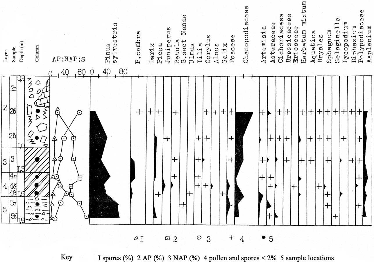
The results of the palynological analysis are presented in Table 7 and Figure 13. The pollen spectra are not identical and are indicative of repeated changes in climate and environment at the site. The palynological characteristics of individual layers (from bottom to top) are given below and an attempt is made to reconstruct the environment at the time.
Palynological diagram of samples from Brînzeni cave

palynological analysis of samples from brînzeni

LAYER 5
Samples 5a and 5б are made up as follows: AP 70.7–86.3%, NAP 10.2–25.2%, spores 3.5–4.1%. AP is dominated by Pinus sylvestris (up to 76.5%) and to a lesser extent by Picea and Pinus cembra. There are a few grains of Betula sect. nanae. NAP is dominated by Chenopodiaceae (up to 8.1%), Poaceae (up to 6.5%), and Artemisia (up to 4.1%). Others are few and not very variegated (Asteraceae, Cichoriaceae). Spores include Selaginella selaginoides, Polypodiaceae, Sphagnum sp., and Asplenium sp. There are traces of ruderal plants (Fagopyrum sp., Plantago sp.), and the presence of Cichoriaceae (eg, Sonchus) may also be indicative of human occupation.
The palynological data indicate the presence at that time of a periglacial wooded steppe (Grichuk Reference Grichuk1973). Pine woods were widespread with a little spruce. The woods occupied the slopes of ravines, and stretched up onto the interfluvial plateaux.
In the river floodplains and at the foot of terraces and slopes were marshes which developed in the cold climate on acid soils poor in nutrients. They were evidently also present on the plateaux, reflecting the influence of islands of frozen ground (Nechaev Reference Nechaev1988). Sphagnum, some grasses, and dwarf birch grew in these marshes. Lycopodium, a plant which likes damp ground, may have appeared occasionally. At present it is characteristic of the tundra and the northern taiga and the alpine and subalpine mountains of Eurasia. Meadow and steppe coenoses were characteristic of the open areas. Xerophytes like Chenopodiaceae and Artemisia grew on eroded slopes or on warmer sandy ridges in the valleys.
LOWER AND MID-PART OF LAYER 4
Samples 4б and 4B comprise: AP 47.6–51.9%, NAP 23.0–42.7%, spores 9.7–25.2%. AP is dominated by Pinus sylvestris, with some P. cembra and Juniperus. Only two grains of Picea were present in one sample. The appearance of Betula sp., Ulmus sp., Tilia sp., and Corylus sp. should be noted. NAP is dominated by Poaceae and Chenopodiaceae, with some Artemisia, Asteraceae, and others. Spores are represented by Bryales, Sphagnum sp., Lycopodium, Polypodiaceae, and Asplenium.
The trees at that time were dominated by pine and birch growing on poor soils. Deciduous species grew in refugia on richer soils and in the valleys. They included elm, lime, and birch, with hazel in the undergrowth. The ground cover consisted of variegated grasses including Ericaceae, Polypodiaceae, and Lycopodium. The marshy areas were occupied by Sphagnum, sometimes with an admixture of spruce. Asplenium must have been growing in cracks and crevices in the limestone rocks, and the fact that it was so widespread must have a local explanation connected with the particular circumstances of the area. Nonetheless taken together with other factors (the appearance of deciduous trees and the absence of arctic-alpine and boreal elements) it does indicate an improvement in climatic conditions (warmer and somewhat wetter).
The widening of the area occupied by variegated grass communities could be connected with the thawing of frozen ground and the spread of very wet subsoils in the periglacial zone, brought about by the improvement in climatic conditions. Xerophyte Chenopodiaceae and Artemisia grew on the interfluvial plateaux or constituted for the most part the coenoses of destroyed substrata. The samples have revealed the presence of some ruderal plants and weeds (Plantago sp., P. major, and Polygonum aviculare) but (as in layer 5) they are few (up to 4% at most) and provide no evidence for a very long occupation of the site.
UPPER PART OF LAYER 4, LAYER 3, LOWER PART OF LAYER 2
Samples 4a, 3, and 2B comprise: AP 48.2–69.5%, NAP 19.0–37.1%, spores 11.4–19.4%. AP is dominated by Pinus sylvestris. There is a considerable increase in Picea sp. Considering that spruce produces very little pollen compared with pine, and that this pollen does not travel far (Iversen Reference Iversen1959), it is reasonable to conclude that it formed a significant component of the woods at that time (Kozyar Reference Kozyar1985). There is a little pollen from deciduous trees, Tilia and Corylus. NAP is dominated by Chenopodiaceae with some Artemisia, and there are also other variegated species, Dipsacaceae, Polygonaceae, Brassicaceae, Cichoriaceae, and Lamiaceae. Aquatica pollen was also found. Spores are represented by Bryales, Polypodiaceae, Sphagnum, Lycopodium, Asplenium, and Diphazium. An increase (up to 8%) in ruderal pollen can be observed in 2B, including Urtica sp., Fagopyrum sp., Polygonum aviculare, and Plantago sp.
At that time there were wooded steppes in the area surrounding the site. The woods were dominated by pine and spruce, and birch was present. In refugia there were occasional lime and hazel.
Xerophyte plants such as Chenopodiaceae, Artemisia, and Diphazium, grew on poor limestone outcrops. They occupied the interfluvial plateaux, scree slopes, and sandy ridges in the valleys. Reed mace and some grasses grew on the banks of swampy water courses. There were meadows on damp ground and they included Poaceae and mesophyte grasses such as Lamiaceae, Primulaceae, and others. It was evidently a time when a cold climate was becoming somewhat damp.
The rather greater number of ruderal plants in comparison with the preceding samples could indicate a relatively prolonged, more than seasonal, human occupation of the site. Judging by the pollen spectra, the area of pine woods mixed with spruce and birch decreased. They occupied a limited space. Ground cover was provided by mosses, Lycopodium, and Polypodiaceae. Asplenium was confined to cracks and fissures in the limestone rocks and boulders. The existence of limited marshy areas is indicated by the presence of hydrophyte and hygrophyte plants, such as Typhaceae and others, as well as spores of Sphagnum.
UPPER PART OF LAYER 2
Sample 2б is made up as follows: AP 18.0%, NAP 68.6%, spores 13.4%. Steppes of periglacial type were dominant. Xerophyte and halophyte grasses played a significant role, particularly Chenopodiaceae with an admixture of Artemisia, as well as Poaceae and others. These species occupied large areas of the interfluvial plateaux and grew on eroded scree slopes. The arctic-alpine species Diphazium cf. alpinum was sometimes encountered. There was an increase in aridity and in cold continentality. The increase (up to 9.3%) in ruderal plants, represented by Polygonum aviculare, Fagopyrum sp., and Plantago cf. major, could indicate a prolonged human occupation of the site. There was some trampling of the area in the vicinity of the cave, which subsequently was colonized by pioneer plants, and the pollen of these plants may consequently be over-represented in the cultural layers at the site, compared with their occurrence in undisturbed natural conditions.
CONCLUSIONS
A gradual evolution took place during the formation of the Upper Palaeolithic layers in Brînzeni cave, whereby the landscape became less wooded, passing from wooded steppe to steppe conditions of periglacial (arid and continental) type. The woods were dominated by pine with some admixture of birch. Willow and alder could be encountered. At certain times when the climate improved somewhat a few deciduous trees (elm, lime, hazel) grew in refugia. Later, in layers 3 and 2, there was an increase in spruce, but it then decreased again in the upper part of layer 2.
The presence, albeit in small numbers, of arctic-alpine and boreal species such as Selaginella selaginoides, Diphazium, Sphagnum, and Betula sect. nanae, is an indicator of periglacial conditions and the existence of islands of frozen ground at that time. The presence of ruderal pollen in the cultural layers and their proportional representation in the spectra can be an indicator of the relative length of human occupation in the cave. It seems that the longest occupation was at the level of cultural layer II (samples 2B and 2б).
Faunal remains from cultural layers II and III
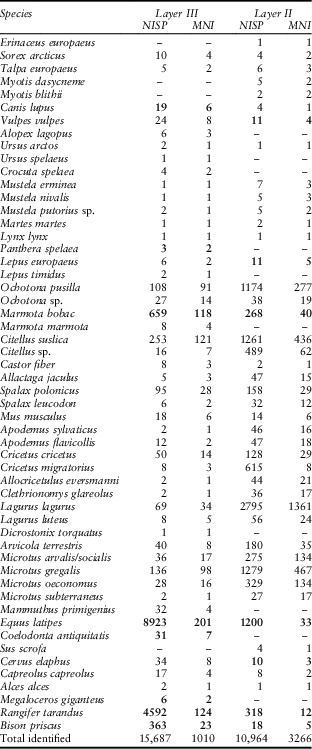
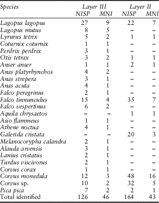
The fauna from N.A. Chetraru’s excavations at the site in the period from 1960 to 1975 have been studied by A.I. David and I.M. Gania (David & Chetraru Reference David and Chetraru1970; Gania & Chetraru Reference Gania and Chetraru1965; David Reference David1980). These results were summarised by Chirica et al. (Reference Chirica, Borziac and Chetraru1996) and by Noiret (Reference Noiret2004; Reference Noiret2009). In addition, David (Reference David1988) studied the fauna from Borziac’s excavations in 1987, information concerning which has not hitherto been available. Taxonomic lists for cultural layers II and III based on the works of these authors, in the order given by them, are provided in Tables 8 and 9. The totals for identified mammals in layers II and III (NISP 10,964 and 15,687 respectively) include the materials added by David in 1988 (NISP 471 and 1252 respectively). Numbers shown in Table 8 in bold indicate that these are different from those hitherto published, for this reason. The new materials recovered in the later excavations, while interesting, do not alter the general balance of the fauna nor do they affect the conclusions previously drawn. The information given by Gania for the identified birds in Table 9 rests solely upon Chetraru’s earlier excavations. The data recovered in 1993 have not been included.
species and frequencies of mammals from cultural layers iii and ii at brînzeni (after david Reference David1980, table 8; 1988)

See text for explanation of bold numbers
species and frequencies of birds from cultural layers iii and ii at brînzeni (after gania & chetraru Reference Gania and Chetraru1965)

The fauna from cultural layer I at the site, which is regarded as belonging to the Holocene, contain a number of domesticated animals, as well as some other material which is considered to be mixed (David Reference David1980, table 8). David notes that the physical condition of the bones in this horizon (in terms of colour, elasticity, specific gravity, and degree of fossilisation) differs markedly from those found in the lower layers, all of which are ascribed to the Pleistocene.
In cultural layer II, according to David, human occupation was restricted to the mid- and back part of the cave (at least in the sector excavated by Chetraru) whereas on the terrace there were enormous quantities of microfauna, accumulated mainly in the form of owl pellets, as well as abundant bird bones (David Reference David1980, 41, 45–6). He emphasises the absence of mammoth, woolly rhinoceros, and giant deer, as well as cave bear, lion, and hyaena. There was a general reduction in the numbers of large animals which, in his opinion, is indicative of a relatively brief human occupation of the site at this time. The remains on the terrace occurred in fissures between large limestone blocks, and in places beneath them, where they could form concentrations up to 200 mm thick.
The fauna from cultural layer III is both abundant and varied. More than 20,000 whole and fragmentary bones (mainly mammals) were discovered during Chetraru’s excavations alone. As indicated in Tables 8 and 9, the great majority could be identified. Numerically, the large mammals are dominated by horse, reindeer, and bison, which together make up 88.4% of the mammalian total given here by NISP or 34.5% by MNI. An alternative list is provided by Noiret (Reference Noiret2009, table 8) where the mammal selection is limited to 15 economically useful species only, in which case the three species mentioned would account for 94.5% by NISP and 67.8% by MNI. According to David and Chetraru (Reference David and Chetraru1970) some bones did have cut marks indicative of butchery. Marmot is included by Noiret among the economically useful species, and if these figures for NISP and MNI are added to those of the three large mammals the percentage occurrence of all four taken together increases significantly. Noiret suggests that this animal was definitely targeted, most probably by trapping rather than hunting, as it was at Ciuntu (Borziac et al. Reference Borziac, Allsworth-Jones, French, Medyanik, Rink and Lee1997). The presence of the other rodents, in Chetraru’s view, is mainly due to the predation of carnivorous birds. David emphasised that the bones in general were scattered throughout the deposits, in various positions, and mainly in a fragmented condition. The presence, albeit in small numbers, of large carnivores such as cave bear, lion, and hyaena, is regarded as significant, since in this area they are usually associated with the Middle rather than the Upper Palaeolithic, and they have often been taken as an at least approximate chronological indicator.
According to David (Reference David1980, 106–16), Equus latipes was widespread in late Pleistocene eastern Europe. This type of horse was first defined by V.I. Gromova at Kostenki (Gromova Reference Gromova1949); subsequently it has been found both at sites with traces of human presence and at those without. At Brînzeni its bones were usually but not always fragmentary, and the complete ones (including four skulls) have allowed the species to be described in some detail. It was of medium size, with massive metapodials and phalanges and broad hooves, said to be adapted to a mainly damp marshy terrain. In David’s view, the predominance of these horse bones in layer III at the site may indicate a comparatively mild climate, possibly interstadial, since this animal was not adapted to very severe conditions. This view has been challenged by Noiret (Reference Noiret2009) who regards the horse as a cold indicator.
Reindeer was one of the most widespread animals throughout the middle and late Pleistocene, and in David’s view it has no exact chronological significance (David Reference David1980, 140–3). He suggests that, because of the proximity of the Carpathian mountains, the reindeer in Moldova was not confined to cold stadial autumns and winters, but could have been present in the region in warmer conditions all year round. Morphologically, it was not significantly different from the present tundra variety, but it had a longer lower tooth row, and shorter metapodials. Bison occurs at practically all the excavated sites in Moldova and the neighbouring countries, but, since it is basically a steppe animal – or at least an animal adapted to open spaces – it is less frequent than horse or reindeer. According to David (Reference David1980, 148–51), the species encountered at Brînzeni is quite large in size. With regard to mammoth, Noiret (Reference Noiret2009) strikes a cautionary note, suggesting that the fairly few remains may be due not to hunting but to scavenging for bones and/or ivory.
Dating the site
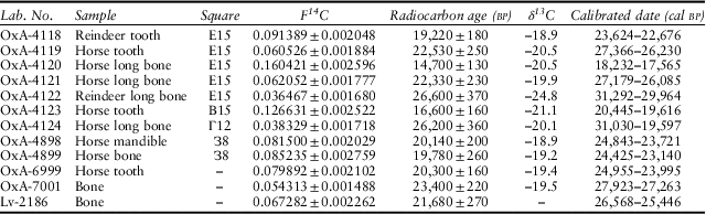
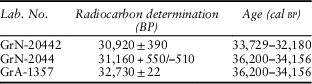
Twelve radiocarbon dates from the site have been published (Hedges et al. Reference Hedges, Housley, Pettitt, Bronk Ramsey and Klinken1996; Bronk Ramsey et al. Reference Bronk Ramsey, Higham, Owen, Pike and Hedges2002; Noiret Reference Noiret2009) as listed in Table 10. The first five samples (OxA-4118 to -4122) were collected in 1992 (as already described) from square E15 at a depth of 1.90–1.95 m below datum. The next two (OxA-4123 and -4124) come from Chetraru’s excavations of 1963, in squares B15 and Г12 but without recorded depths, and were made available by A.I. David from the collections of the Zoological Institute in Chișinău. OxA-4898 and -4899 come from square З8 (wrongly listed as Ф8 in Hedges et al. Reference Hedges, Housley, Pettitt, Bronk Ramsey and Klinken1996) in the section described here, and were collected on 23 and 24 July 1993 at depths of 1.65 and 1.72 m, in immediate proximity to the horse mandible. Hedges et al. (Reference Hedges, Housley, Pettitt, Bronk Ramsey and Klinken1996), commenting on the first nine results achieved, stated that the ‘two dates obtained from the control section’ (20,140±200 and 19,780±260BP) ‘are very consistent and fall in the middle of the previous very scattered set’ (from 26,600 to c. 14,700BP) ‘but while they provide an apparently reliable age determination for that particular part of the sequence, they still leave open the question of the interpretation to be given to the layer as a whole in the light of all the dates reported here’. The last three samples were submitted by Marcel Otte to the laboratories in Oxford and Louvain in an effort to ‘resolve the problem’ of a ‘chronological range that is too broad’ (Bronk Ramsey et al. Reference Bronk Ramsey, Higham, Owen, Pike and Hedges2002). The samples (OxA-6999 and 7001, and Lv-2186) were provided by Borziac but without an indication of their precise provenance within cultural layer III. Noiret (Reference Noiret2009, 81) expresses the opinion that the three dates obtained (in the range from 23,400–c. 20,300BP) ‘confirment d’une certaine manière la validité des deux résultats obtenus pour la sequence de la terrasse’, but clearly the wide range of dates obtained for the site as a whole still requires an explanation. Rink (Reference Rink1996) reported a preliminary ESR date for layer 4 (cultural layer III) of 16,300±4700 (LU) based on gamma dose rates derived from sediment. He commented that this date was younger than but in broad agreement with the mean AMS age for the layer, and in his view the total spread of dates obtained by the two methods also provided a good match. It was consistent with the idea that layer 4 accumulated over a long period of time.
radiocarbon dates from brînzeni cultural layer iii

For calibration OxCal 4.2 (Bronk Ramsey Reference Bronk Ramsey2016) and IntCal13 (Reimer et al. Reference Reimer, Bard, Bayliss, Warren Beck, Blackwell, Bronk Ramsey, Buck, Cheng, Lawrence Edwards, Friedrich, Grootes, Guilderson, Haflidason, Hajdas, Hatté, Heaton, Hoffmann, Hogg, Hughen, Kaiser, Kromer, Manning, Niu, Reimer, Richards, Scott, Southon, Staff, Turney and Plicht2013) was used: F14C figures kindly provided by Rachel Hopkins
The dates as published hitherto were all uncalibrated. The first seven of the Oxford dates were processed in 1993 and the two from the control section in 1994. All received pre-treatment according to the laboratory’s AI protocol in use at the time, a continuous-flow acid-base-acid gelatin method with ion exchange to extract purified collagen from the bone and tooth samples (Hedges et al. Reference Hedges, Law, Bronk and Housley1989). The last two of the Oxford dates were processed in 1997 according to the laboratory’s revised AG protocol, whereby pre-treatment was carried out manually, but without ultrafiltration (Brock et al. Reference Brock, Higham, Ditchfield and Bronk Ramsey2010). In this case, carbon:nitrogen weight ratios were obtained, and were found to be within the acceptable range (2.8 and 2.9). The dates obtained at the Oxford laboratory, and the single result from Louvain, have now been calibrated, using OxCal 4.2 (Bronk Ramsey Reference Bronk Ramsey2016) and IntCal13 (Reimer et al. Reference Reimer, Bard, Bayliss, Warren Beck, Blackwell, Bronk Ramsey, Buck, Cheng, Lawrence Edwards, Friedrich, Grootes, Guilderson, Haflidason, Hajdas, Hatté, Heaton, Hoffmann, Hogg, Hughen, Kaiser, Kromer, Manning, Niu, Reimer, Richards, Scott, Southon, Staff, Turney and Plicht2013), and the results at the 95.4% level are shown in Table 10. The table also shows the F14C or fraction modern values as recommended by Reimer et al. (Reference Reimer, Brown and Reimer2004). These values directly reflect the difference between the 14C/12C ratio as established for the sample (after correcting for fractionation) and the 14C/12C ratio in modern carbon, defined as that which would have obtained in 1950. They provide the basis for all further calculations, and for this reason their publication and use is recommended by radiocarbon dating specialists. Obviously, the calibrated values can be expected to more closely reflect reality than the original uncalibrated results, but they do not greatly change our perception of the site at the present time. The preferred two dates from the control section uncalibrated average about 20,000 yearsBP, while their calibrated equivalents are approximately 4000 years older than that. As might be expected, the range of dates represented also does not undergo a significant alteration. In both cases, from oldest to youngest, there is a range of about 12,000 years or more, so an explanation for this still has to be sought. In the light of results obtained elsewhere, eg, those mentioned by Higham (Reference Higham2011), it is likely that if these samples or others from the site were re-dated using ultrafiltration they might turn out to be several thousand years older than present estimates, although one could not predict the extent to which the spread of dates might be affected.
The archaeological finds at Brînzeni and their interpretation
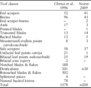
Details of the finds from cultural layer II were given by Chetraru in his first publication (Chetraru Reference Chetraru1973, 142, fig. 50) and nothing substantial has been added since. The 740 artefacts, according to Chetraru, included end scrapers, burins, retouched points, notched blades, and backed bladelets, as well as numerous retouched bladelets, and small prismatic cores. As noted already, Chetraru ascribed this layer to the Mesolithic, but Borziac regarded it as late Upper Palaeolithic. The description and classification of the finds from cultural layer III has proved to be far more significant and controversial. The most accessible account of the inventory from this layer has been given by Chirica et al. (Reference Chirica, Borziac and Chetraru1996), but this for the most part represents a translation into French from Borziac’s unpublished Russian language version of 1994, and a comparison of the two helps to provide some clarification and correction. As explained by Noiret (Reference Noiret2009), in May 1995 he was enabled to re-examine the entire collection from this layer, together with Marcel Otte and Ignacio López Bayón, as a result of which he reached conclusions which in some respects differ markedly from those championed by Chetraru. The differences are particularly acute in respect of the retouched tool classes, as shown in Table 11. Whereas Chetraru and Borziac (in Chirica et al. Reference Chirica, Borziac and Chetraru1996, 23) gave a total for these tool classes of 1378, Noiret (Reference Noiret2009, 90–1) considered that a reliable minimum would not exceed 200. Noiret remarked on some apparent ambiguities in the French text, eg, in relation to the so-called pointes foliacées and pièces bifaciales, which by reference to the Russian text in fact mean unifacial and bifacial leaf points respectively. These ambiguities have been eliminated in the English language version given here in Table 11.
artefact inventory lists for brînzeni cultural layer iii

after Chirica et al. Reference Chirica, Borziac and Chetraru1996, 23, and Noiret, Reference Noiret2009, 90–1; Russian terminology after Borziac Reference Borziac1994
In respect of the industry as a whole, the descriptions and figures given here are based on those provided by Chirica et al. (Reference Chirica, Borziac and Chetraru1996) and Borziac (Reference Borziac1994). According to their account, cultural layer III (apart from the retouched tools) produced a total of 7155 artefacts of flint, divided into the following categories: 22 unworked nodules, 327 cores, 757 blades, 5160 flakes, 41 core rejuvenation flakes, and 848 splinters. The majority of the flint was a local fine-grained grey variety, a minority also of good quality being black, derived from the river Pruth. The 327 cores were classified as: 99 discoidal and sub-discoidal, 139 sub-prismatic, 9 wedge-shaped, 20 secondary, 14 others, and 46 fragments. The sub-prismatic cores were therefore said to constitute the main determinant of the reduction sequence adopted at the site. By secondary cores were meant cores produced on blanks which were already flakes. The so-called wedge-shaped cores deserve a particular mention, since they are described in detail only in Borziac’s text, and they throw an unexpected light on the industry as a whole. It turns out that these are what have sometimes erroneously in the past been termed ‘gigantoliths’. In fact they are an elaborate type of core or pre-core which, as Borziac points out, has long been singled out by Polish archaeologists under the name obłupień (from obłupać/ić to ‘peel’ or ‘bark’). This type of core is well illustrated for example in Krukowski et al. (1939–Reference Krukowski, Kostrzewski and Jakimowicz48, fig. 25, Grzybowa Góra). These objects were made for the production of blades, along one edge, after the removal of a crested guide flake. As such, they must be reckoned quite an advanced phenomenon. Figure 14 is a photograph of one of the most notable of these cores (previously exhibited in the Museum in Chișinău). It is in grey flint, and is quite large: 177×86×56 mm (Museum number БрI-65 III 14н инв.N.417). Out of 3962 striking platforms examined by Chetraru and Borziac, 46.84% of blades and 44.32% of flakes were found to be facetted or dihedral. No precise statement regarding the Levallois component of the industry occurs in any of the published accounts, and tools made on Levallois blanks do not appear in the list of tool classes, but this technique was undoubtedly present (Chirica et al. Reference Chirica, Borziac and Chetraru1996, 21; Noiret Reference Noiret2009, 83, fig. 38). Apart from the flint artefacts, there were 28 of quartzite, and 86 of sandstone, which probably deserve more attention than they have been given in the literature. Apart from fragments, these were mostly flat slabs, interpreted as anvils for flint or bone working, or as rubbers or grinders for the processing of vegetable matter.
Wedge-shaped core (obłupień)

In respect of the retouched tools, the discrepancies between the two lists given by Chirica et al. and by Noiret are less than they appear at first sight, bearing in mind that 1073 of the total given by the first authors consists of five classes (notched blades and flakes, denticulates, retouched blades and flakes, splintered pieces, and naturally backed knives) which are regarded by Noiret (Reference Noiret2009, 90–1) as the product of natural processes, and not as intentional tools. It is difficult to disagree with this conclusion. We have noted already that at Bacho Kiro layer 11 and Temnata Dupka locality I layer 4 tool totals may be revised downwards, and the same is true at Kara Bom (discussed below) where, for reasons similar to those here, notches and naturally backed knives have been excluded from the revised count (Zwyns et al. Reference Zwyns, Rybin, Hublin and Derevianko2012). Noiret considers that a minimum of perhaps 30 pieces or so (originally placed in the classes mentioned above) might be regarded as intentional, hence the inclusion of this figure in Table 11. But leaving these disputed categories aside, the respective totals for retouched tools amount to no more than 305 (Chirica et al.) and 169 (Noiret). The differences between these reduced lists (once some terminological misunderstandings are cleared away) are of degree rather than kind, and generally their assessments are similar. The end scrapers include some which can be classified as carinate, although there are no carinate burins, which would generally be regarded as an Aurignacian characteristic (Chirica et al. Reference Chirica, Borziac and Chetraru1996, 27, figs 22 & 23; Noiret Reference Noiret2009, 84–6, figs 40–4). In contrast, the few backed blades present would commonly be regarded as associated with the Gravettian. Noiret (Reference Noiret2009, fig. 45) agrees that there are a few pieces which can fairly be classified as Mousterian points, and also that the large number of side scrapers could be interpreted as an ‘archaic’ element (ibid., 93). However we may call them, the presence of bifacially worked tools is also undeniable, but whether they should be called ‘archaic’ is another matter, since as all authors agree, many of them are unfinished roughouts abandoned in course of manufacture (Borziac Reference Borziac1994; Chirica et al. Reference Chirica, Borziac and Chetraru1996, 26). In general, the ‘archaic’ aspect of the industry is much reduced if the five classes largely eliminated by Noiret are excluded, since they made up a vital part of the supposed ‘archaic’ constituent in the interpretation favoured by Chetraru and Borziac (Chirica et al. Reference Chirica, Borziac and Chetraru1996, 26).
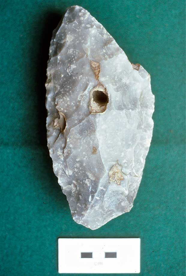
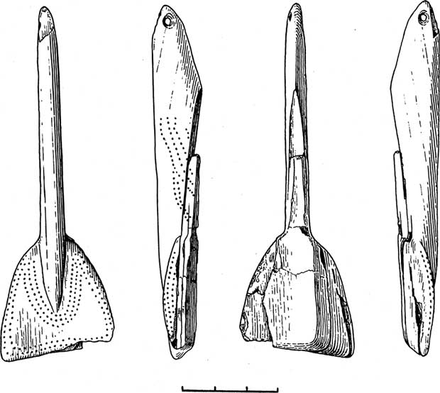
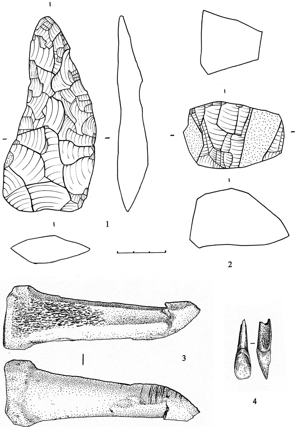
The rare bone artefacts discovered also indicate the relative sophistication of the makers. The best known is a mammoth ivory amulet, details of which have been published by Chetraru (Reference Chetraru1970; Reference Chetraru1989; illustrated here as Fig. 15). As he says, the object was found in 1965 when sorting through the animal bones, but there is no doubt as to its provenance. It came from the interior of the cave, in line 14, near the base of the deposit, where the archaeological layer was compressed beneath large boulders. It had been damaged in antiquity, and then again during its retrieval, although the latest damage could for the most part be repaired. The small aperture at the top indicates that the piece was suspended, and it is likely to have been worn as an ornament. Its maximum dimensions are 111×38×17 mm, in two rather distinct sections, both of which are decorated with rows of punctations, probably originally filled with red ochre. Chetraru could find no close analogy for this piece, the nearest suggested by him (on the basis of the punctations) being the figurine of a horse found at Sungir’ (Bader Reference Bader1978). In addition, a fragment of a hare long bone with worked or polished ends was discovered in 1987, and in 1991 when sieving the soil to recover microfauna a perforated horse incisor, evidently also used as a pendant, was found (Fig. 19.4). Three horse bone fragments with marks suggesting their use as anvils or retouchers were found at the same time (Fig. 19.3).
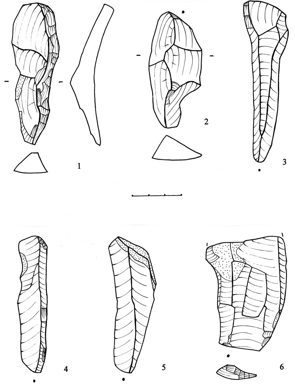
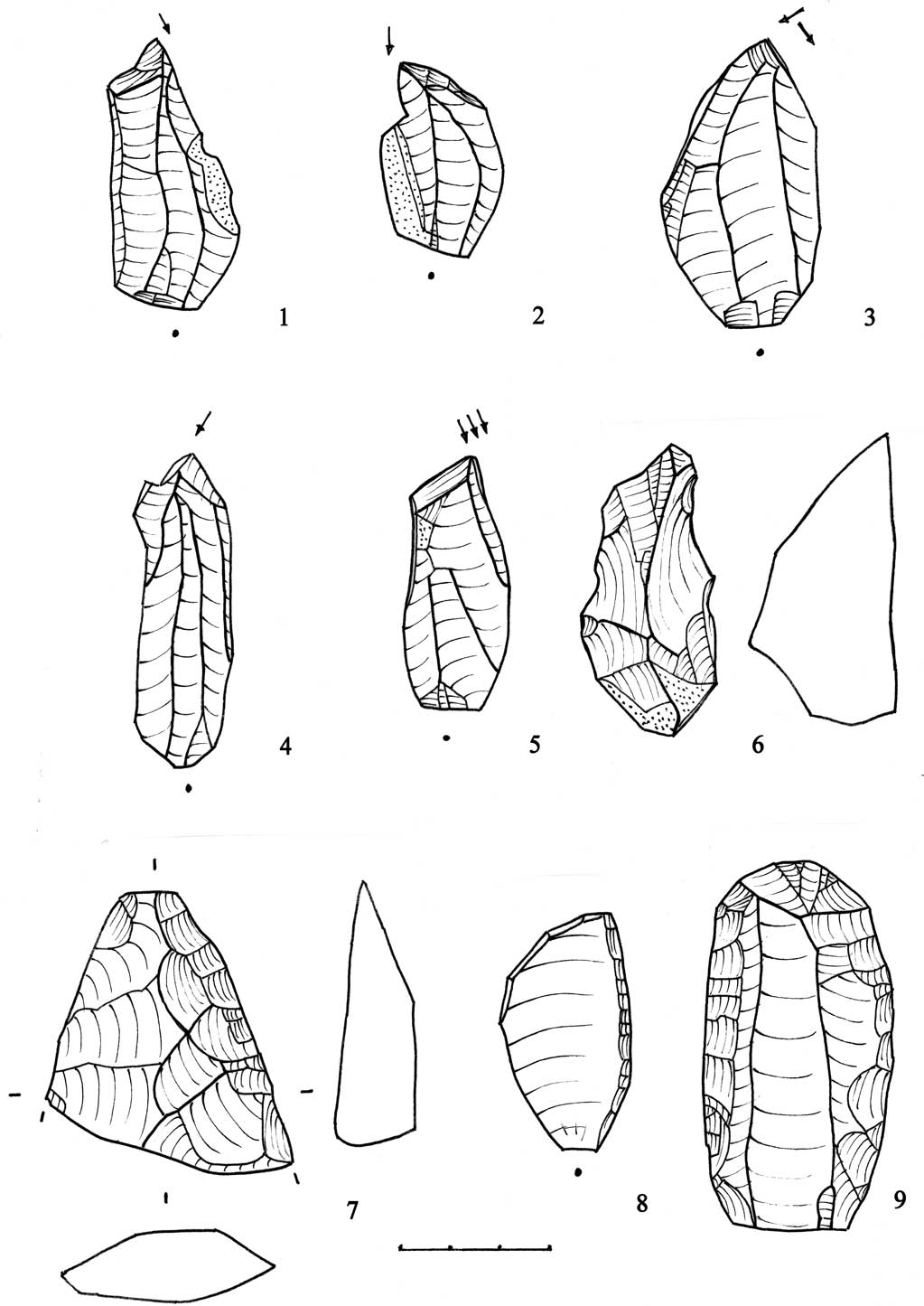
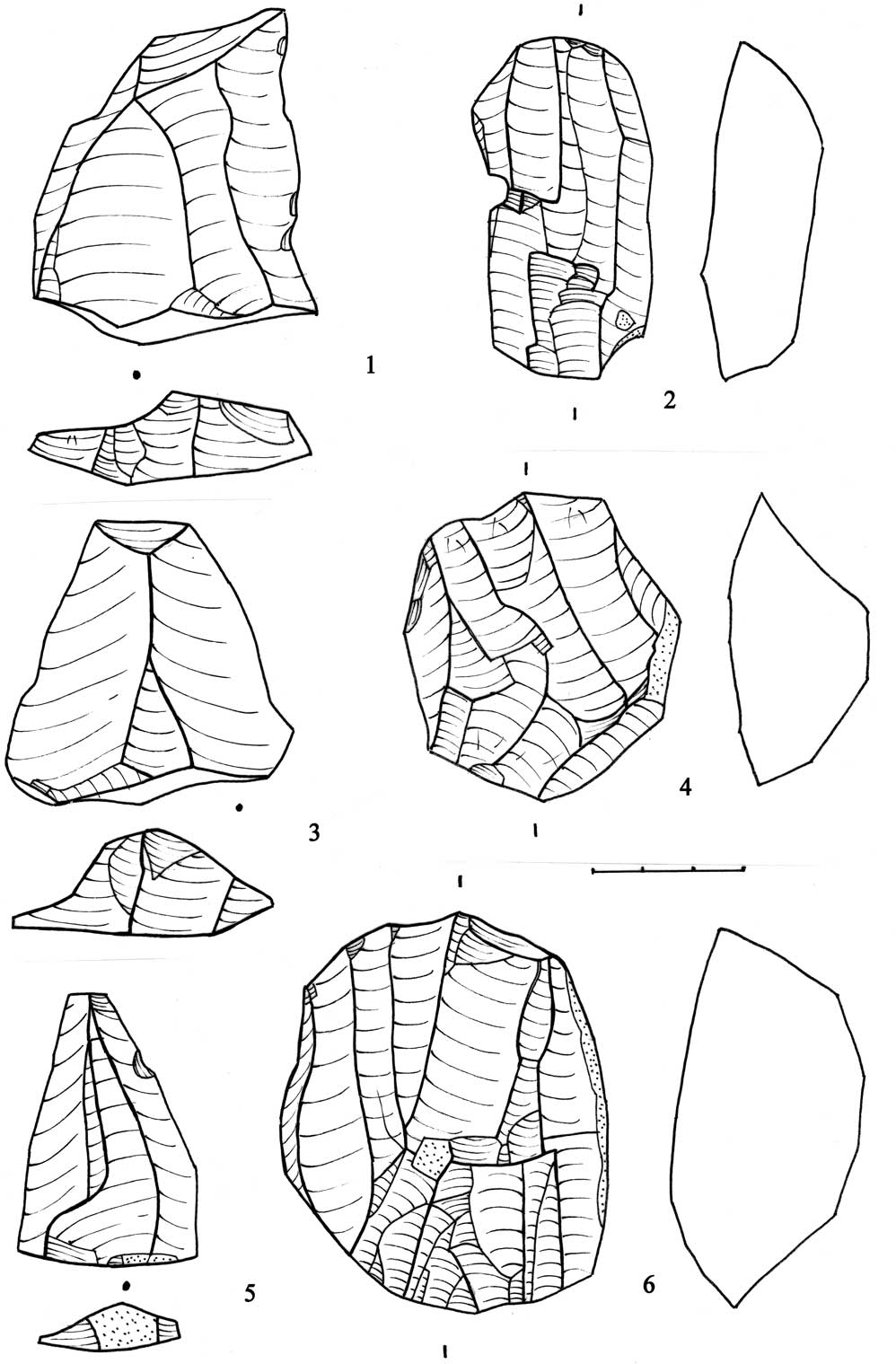
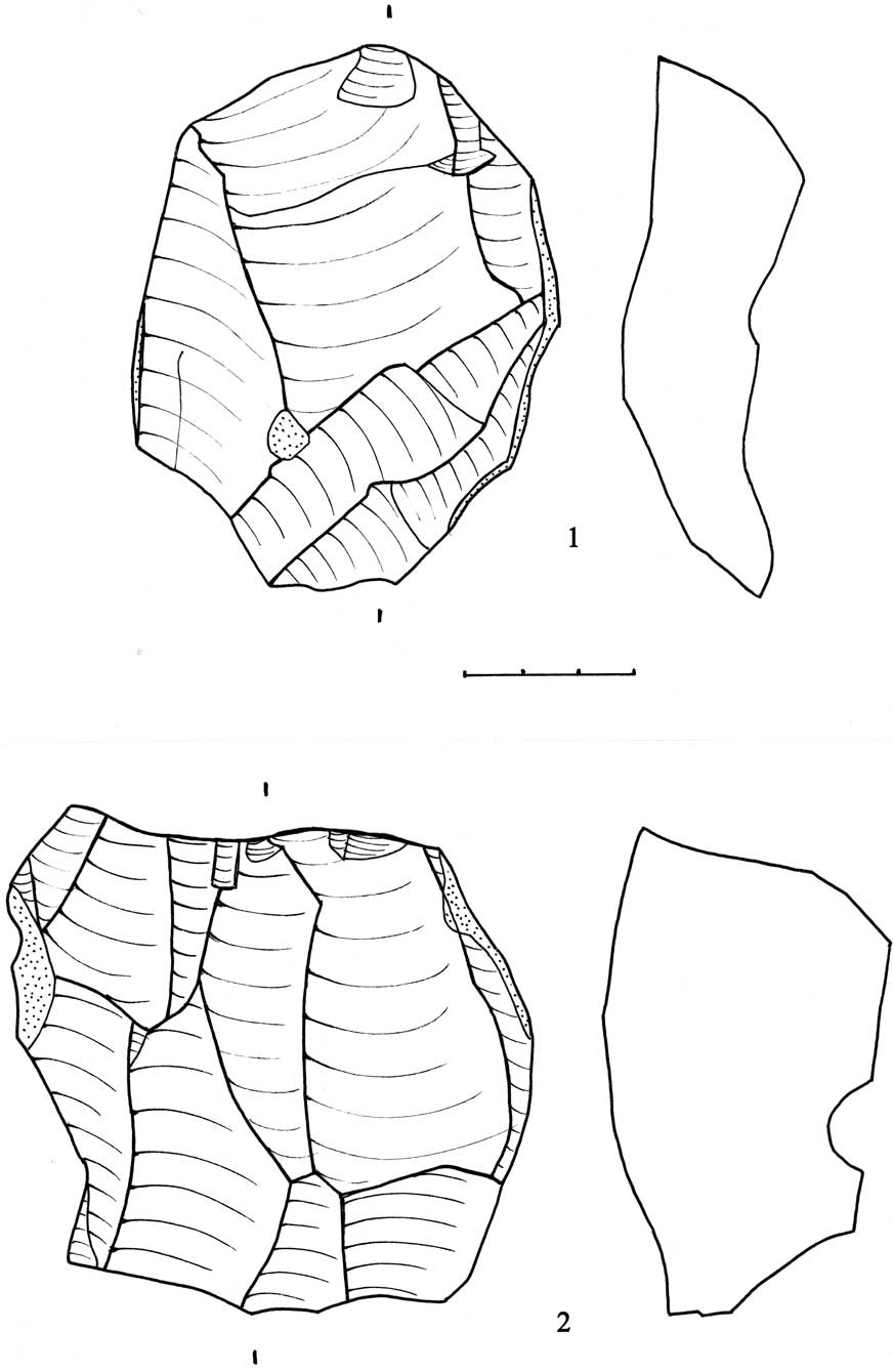
It was possible to re-examine Chetraru’s collection of material from the site at the Archaeological Museum in Chișinău in 1992. Twenty-five of those artefacts are illustrated here (Figs 16–20). Obviously these drawings represent no more than a small selection of the material, but an attempt was made to obtain a sample representative of the whole, both typologically and technologically. Fourteen are in grey and 11 in black flint. On the one hand, there are clear indications of Upper Palaeolithic techniques. This is shown in the presence of crested guide flakes (Fig. 16.1 & 2), and pronounced blades, some of which were struck from two-platform cores (Fig. 16.3–5). On the other hand, Figure 16.6 shows what was evidently a (broken) Levallois blade, and three Levallois points are illustrated (Fig. 18.1, 3, & 5). This apparent mixture of techniques has been commented on before in previous published accounts. There are also clear Upper Palaeolithic type tools, including burins (Fig. 17.1–5) and end scrapers (Fig. 17.6 & 9), as well as others, such as side scrapers (Fig. 17.8). The presence of bifacial leaf points has always attracted attention. The two illustrated here (Figs 17.7 & 19.1) are characteristic of the site as a whole, in that the first is broken and the second is unfinished. The cores also display a degree of technological heterogeneity, which might be expected in the light of the pieces illustrated above. Relatively advanced two-platform blade cores are illustrated as Figures 18.2, 4, & 6, & 19.2. In contrast, what can also be called blade cores (Fig. 20.1 & 2) are not so clear-cut, and probably fall into what have hitherto been described as sub-prismatic or even discoidal varieties. This selection of drawings should be sufficient to indicate why the material from cultural layer III has previously been referred to, rightly or wrongly, as ‘transitional’ in nature.
Mammoth ivory amulet (after Chetraru, Reference Chetraru1973, fig. 29)

Artefacts from cultural layer III. 1 & 2: crested guide flakes; 3–5: blades; 6: Levallois blade, broken at the top

Artefacts from cultural layer III. 1 & 2: truncation burins; 3: dihedral burin; 4 & 5: angle burins; 6. nosed end scraper; 7: bifacial leaf point, broken at the base; 8: side scraper on ventral surface; 9: end scraper

Artefacts from cultural layer III. 1, 3, & 5: Levallois points; 2, 4, & 6: two-platform blade cores

Artefacts from cultural layer III. 1: bifacial leaf point, unfinished; 2: two-platform blade core; 3. utilised horse bone; 4: horse tooth pendant (3 & 4 after Elena Fraseniuc)

Artefacts from cultural layer III. 1 & 2: discoidal and sub-prismatic two-platform cores

THE INDUSTRY FROM CULTURAL LAYER III IN A WIDER CONTEXT
In his first formulation, Chetraru (Reference Chetraru1973, 73) suggested that the industry in cultural layer III could perhaps be regarded as an ‘eastern variant’ of the Szeletian, or rather the representative of a separate ‘Brînzeni culture’. This culture has been portrayed as typical of the Early Upper Palaeolithic, with an amalgam of Mousterian, Szeletian, and Aurignacian forms, indicative of a ‘transition’ from the preceding Middle Palaeolithic (Chirica et al. Reference Chirica, Borziac and Chetraru1996, 167, 175–7). In the ‘historical-cultural region’ between the Dniester and the Carpathians (Rogachev & Anikovich Reference Rogachev and Anikovich1984, 174–5) it does not however stand alone; in fact it forms part of what Borziac (Reference Borziac1983) referred to as a ‘complex mosaic picture’. According to the scenario which he developed at that time, the Upper Palaeolithic in this area consisted of four groups, of which two could be considered as belonging to the early stage. While the first group was centred on Brînzeni, the principal representative of the second was Gordineşti, excavated by him in 1974–76 (Borziac Reference Borziac1984). In Borziac’s view, the differences between the two sites were sufficient to warrant the creation of a new taxonomic unit which he called the ‘Pruth culture’ (Borziac Reference Borziac1983, 52). The whole picture as presented at that time is summarised in Allsworth-Jones (Reference Allsworth-Jones1990, 221–6), where the author also expressed the view that the suggested scenario was over-complicated, and that we were ‘essentially dealing with a single early Upper Palaeolithic entity in this area’. At all events, Brînzeni, in view of its supposedly ‘archaic’ inventory, was still regarded as necessarily early. For this reason, Borziac and Chetraru were initially unwilling to accept that the first radiocarbon dates for the site obtained in Oxford (Hedges et al. Reference Hedges, Housley, Pettitt, Bronk Ramsey and Klinken1996) could possibly be correct (Chirica et al. Reference Chirica, Borziac and Chetraru1996, 30, 168).
A radically different interpretation has more recently been given by Noiret (Reference Noiret2004; Reference Noiret2009). In so doing, he has been able to draw on the excellent stratigraphic results achieved by Haesaerts and his colleagues on the basis of three long open air sequences at Molodova V, Mitoc-Malu Galben, and Cosăuți (Haesaerts et al. Reference Haesaerts, Borziac, Chirica, Damblon, Koulakovska and Plicht2003, figs 5 & 8). At Mitoc-Malu Galben in particular six distinctive soil formation units (labelled MG 13–9 and 6) were identified, with which it was possible to correlate Aurignacian occupations I–III and the first Gravettian occupations I–II at the site; later Gravettian occupations III–IV are associated with a further soil formation unit MG 4 (Noiret Reference Noiret2009, fig. 4, 55). These results allowed Noiret to draw up a chrono-stratigraphic scheme for the region as a whole, plotting the occurrence of dated Aurignacian and Gravettian sites, in comparison with those previously regarded as ‘transitional’, including Brînzeni (ibid., fig. 352, 480). From this it clearly appears that Aurignacian occupations I–III at Mitoc-Malu Galben constituted the first definite Upper Palaeolithic sites in the area. They have uncalibrated radiocarbon dates in the range 32,700–29,500BP, whereas the Gravettian I and II occupations are dated to the interval 27,500–25,500BP. Noiret (ibid., 76) emphasises that the Aurignacian at Mitoc does not contain any bifacially worked pieces nor large numbers of tools which could be called ‘archaic’. In his view, in the light of the available radiocarbon dates, Brînzeni and other sites with which it could be compared occupied an intermediate interval extending from the end of the Aurignacian to the earliest phases of the Gravettian. This interval is bounded by or contains three soil formation units, MG 9, MG 8, and MG 6. Hence the author suggested that the Aurignacian style elements at Brînzeni, and more particularly the Gravettian style elements, might possibly be the result of contact with the site’s neighbours, at either end of the scale (ibid., 484, 486). The appellation ‘transitional’ was not considered appropriate, the more so since at those sites in the region where there is documented superposition of Middle and Upper Palaeolithic levels (Ripiceni-Izvor, Molodova V, Korman IV) there is always a marked stratigraphic hiatus between them (Noiret Reference Noiret2009, 493, 525).
This reconstruction of events is not affected by the calibration procedure and results for Brînzeni mentioned above, which, as we have seen, suggest that cultural layer III at that site is some 4000 years older than hitherto assumed, since the same is likely to apply to the other sites mentioned by Noiret. This may be illustrated by the dates for the first Aurignacian horizon at Mitoc, crucial for the argument that this in fact was the first Upper Palaeolithic in the region. The three dates concerned have been calibrated (Table 12), using the same procedure as outlined above in the case of Brînzeni.
dates for the first aurignacian horizon at mitoc

As can be seen, the calibrated dates are on average some 2000–5000 years older than their uncalibrated equivalents, and there is still a substantial gap of more than 10,000 years between them and their counterparts at Brînzeni. All the samples in this case are charcoal and, therefore, if they were subjected to the ABOx-SC procedure, it is likely that they would be older still, as demonstrated by Wood et al. (Reference Wood, Douka, Boscato, Haesaerts, Sinitsyn and Higham2012).
Noiret (Reference Noiret2009, 487) suggested that in terms of the composition of the industry in cultural layer III a good comparison could be made between Brînzeni and Bobulești VI (which was always Chetraru’s position) but also between Brînzeni and Gordineşti. These three sites constituted the core of an entity which, following Borziac, he preferred to call the ‘Pruth culture’ (ibid., 506). In his view there are too many uncertainties surrounding Brînzeni itself for this name to be employed (ibid., 404). The name of the river is neutral and its use in an economical way conveys the correct impression that the sites attributed to this entity occupy a geographic area distinct from the Gravettian. For the time being, there are sound reasons to accept this solution.
CONCLUSION
The site of Brînzeni has been well known in the region since Chetraru’s first publication in 1973. Cultural layer III was designated as ‘transitional’ in nature, suggesting that it formed a link between the Middle and the Upper Palaeolithic, with the additional implication that it should be chronologically quite early. The first radiocarbon dates for the site were obtained thanks to fieldwork done in 1992–93, and they were promptly published (Hedges et al. Reference Hedges, Housley, Pettitt, Bronk Ramsey and Klinken1996). The two dates obtained on the terrace (20,140±200 and 19,780±260BP) were considered to provide ‘an apparently reliable age determination for that particular part of the sequence’, and they were not inconsistent with three dates obtained later in the range 23,400–c. 20,300BP (Noiret Reference Noiret2009). Such a chronology was not expected in the light of the previous assumptions about cultural layer III, and the nature of the industry was also called into question as a result. In Noiret’s scheme (2009, fig. 352) Brînzeni is subsumed into a ‘Pruth’ culture, which is considered to occupy a chronologically intermediate position between the Aurignacian and the Gravettian in the area.
The calibrated results shown here indicate that the two dates from the terrace are equivalent respectively to 24,843–23,721 and 24,425–23,140 calBP. In other words, they are in real terms about 4000 years older than previously stated. Broadly speaking, the same applies to all the other dates from the site, and results from the other sites mentioned by Noiret could be expected to show the same tendency. This can be illustrated by reference to the first Aurignacian horizon at Mitoc, where the three calibrated dates (Table 12) are between 2000 and 5000 years older than originally estimated, which still leaves a gap of more than 10,000 years between them and their counterparts in Brînzeni. The scheme suggested by Noiret therefore still remains intact for the moment.
Apart from the absolute age to be expected for cultural layer III at the site, the other issue raised by the first radiocarbon dates to be published concerned their apparently broad chronological range, of c. 26,600–14,700BP. The calibrated equivalents of those two dates are 31,929–29,964 and 18,232–17,565 calBP. In other words, for this cultural layer there is still a range of 12,000 years or more. As in other cases mentioned by Higham (Reference Higham2011), it is possible that some of these dates may on re-examination turn out to be too young, but the nature of the layer itself suggests that this may not be a sufficient explanation. Grishchenko (Reference Grishchenko1966; Reference Grishchenko1969) suggested that the upper part of this layer (5 in his numbering) had been subjected to chemical weathering (reflecting an increase in temperature and humidity) and that it had been exposed to the elements for a considerable time (Tables 3 & 4). Its end was marked by a rock fall, which may bear some relationship to the stratigraphically sterile layer 3 detected by Borziac on the terrace between cultural layers III and II.
The micromorphological analysis indicates that stratigraphic layer 4 (corresponding to cultural layer III) consists mainly of loessic wind-blown material, successive episodes of which were subjected to frost-heave, continued percolation of water, and bioturbation. There is no indication of any real soil formation. This accords with observations made by the excavators that the archaeological material was unevenly distributed and that some of the faunal material occurred in such a position as to indicate disturbance. All this suggests that stratigraphic layer 4 is indeed a complex phenomenon and that it could have extended over a long period of time. Both Chetraru and Borziac are adamant however that the archaeological material was homogeneous and that (contrary to the implication by Grishchenko) it could not be divided into separate Upper Palaeolithic and Mousterian components.
The palynological analysis (on the basis of Borziac’s 1987 profile) provides a convincing and detailed record of climatic change from stratigraphic layer 5 through to layer 2 (the latter being equivalent to cultural layer II). In general there was a tendency through time to move from a periglacial wooded steppe to a more open kind of periglacial landscape. It is noticeable that, although layer 4 was dominated by pine and birch, some deciduous species were present, and there are indications of warmer and wetter conditions. Some disturbance-tolerant species could be taken as a sign of human presence, although Medyanik does not think that an intensive occupation is indicated. Later, the climate became distinctly colder and more arid, although cultural layer II in her opinion has more convincing signs of human occupation thanks to the presence of the disturbance-tolerant species. No precise chronological scale can be inferred from her account, but a climatic amelioration at some point in stratigraphic layer 4 would accord with Grishchenko’s interpretation. It would be tempting to assume that this amelioration might correspond to one of the episodes recognised at Mitoc-Malu Galben (Noiret Reference Noiret2009, fig. 352, 480) but that is no more than speculation at the moment.
Clearly the abundant fauna (quite apart from the archaeological remains) demonstrates that there was in fact considerable human activity at the cave at the time of the formation of cultural layer III. Horse, reindeer, and bison are the dominant species present, and their fragmented state leaves no doubt that they were hunted. Marmot may be added, if it is assumed that this animal was trapped, rather than hunted. There is some difference of opinion as to the climatic inferences that may be made on the basis of the fauna, since in David’s view Equus latipes was not adapted to very severe conditions, and if that is the case, the strength of the suggestion that possibly interstadial conditions did exist at some point during the formation of stratigraphic layer 4 would be increased. The predominance of microfauna in cultural layer II (as well as the relatively restricted number of artefacts) surely is convincing evidence that this was mainly a haunt of raptorial birds.
A re-examination of the artefacts from cultural layer III leaves little doubt that their ‘archaic’ character has previously been exaggerated. Technologically and typologically, Upper Palaeolithic characteristics are clearly present, and the relatively sophisticated nature of the assemblage is emphasised by the appearance of the mammoth ivory amulet justly celebrated by Chetraru as part of it. Nonetheless, the picture is not entirely straightforward. Side scrapers constitute a fair proportion of the retouched tools, and while there are advanced Upper Palaeolithic type cores, there are others which are more reminiscent of Middle Palaeolithic procedures. The presence of a Levallois component is undeniable, including one Levallois point found together with three characteristic burins in the immediate vicinity of the horse mandible in 1993. As already noted, both Borziac and Chetraru maintained that the inventory from this layer constituted one assemblage, not a mixture of separate Upper and Middle Palaeolithic components.
In that case, obviously there might be some points of comparison to one or other of the ‘transitional’ industries mentioned in the introductory section, despite the various problems of context and definition which they undoubtedly have. Intriguingly enough, from a strictly technical and typological point of view, it is impossible not to be struck by the apparent similarities between the inventory from layer III at Brînzeni and that from another site altogether, that of Kara-Bom (Zwyns et al. Reference Zwyns, Rybin, Hublin and Derevianko2012; Hublin Reference Hublin2015, fig. 2). Kara-Bom is far away in Siberia. This has not prevented the Initial Upper Palaeolithic at the site from being compared with the Bohunician in central Europe (Svoboda Reference Svoboda2007, fig. 27.2). It was identified in layers 5 and 6, with an estimated age between 46,000 and 40,000 years ago. The inventory of 394 pieces, as at Brînzeni, excludes numerous notches and naturally backed knives, which were previously said to be part of it (Zwyns et al. Reference Zwyns, Rybin, Hublin and Derevianko2012, 39 & table 2). The ‘convergent blanks’ produced are indistinguishable from Levallois points, and there are Levallois blade cores which could equally well be described as sub-volumetric (ibid., fig. 11.7 vs. Hublin Reference Hublin2015, fig. 2.15). Refits show that points could be produced on sub-prismatic cores (Zwyns et al. Reference Zwyns, Rybin, Hublin and Derevianko2012, fig. 11.8). Crested blades are conspicuous, and the authors emphasise the presence of what they call burin-cores, ie cores produced on thick flakes (ibid., fig. 10). It is possible that these correspond to the ‘secondary cores’ detected at Brînzeni. Most of the elements described can in principle be observed in the drawings of material from Brînzeni shown here in Figures 16–20: crested guide flakes, blades, Levallois points, and two-platform blade cores, whether sub-prismatic or not. Zwyns and his colleagues state that whereas the material from Kara-Bom was previously described as a ‘transitional’ technology – showing a shift from a Levallois blade reduction sequence towards reduction based on prismatic and narrow-face cores – in actual fact there was a single process at work, showing a combination of techniques which formed part of one system (Zwyns et al. Reference Zwyns, Rybin, Hublin and Derevianko2012, fig. 14).
It is possible that something similar to this was the case at Brînzeni. That is not to suggest for a moment that there was ever any kind of connection between these two sites. Independent convergent development is a much more parsimonious explanation. No matter what dating revision may affect the site in future, it is perhaps unlikely that Brînzeni will ever find itself in the 46,000–40,000 year old bracket. That is also the bracket occupied by the multifarious Initial Upper Palaeolithic industries shown by Hublin (Reference Hublin2015, fig. 7) occupying the European space prior to the time of the Campanian Ignimbrite. On the basis of the existing evidence, Brînzeni was later than that, and the suggestion that it formed part of a separate entity running parallel to the Aurignacian and the Gravettian in the region is eminently reasonable. In a broader perspective, the important role which this site has played in the development of our concepts concerning the Palaeolithic in Moldova should be recognised. It deserves to be better known internationally, and it is hoped that this paper will help to achieve that end.
Acknowledgements: This work could not have been done without the whole-hearted support of Nicolae Chetraru and Ilie Borziac and their colleagues in Moldova, particularly the Directors of the Museum of Archaeology and the Institute of Archaeology in Chișinău, Eugeniu Sava and Valentin Dergaciov, and their staff. Those who took part in the excavations at Brînzeni in 1993 included Sergei Covalenco, Tudor Golovan, Vladimir Tel’no, and Ruslan Zaporozhan. Elena Fraseniuc drew the two artefacts shown here as Fig. 19.3–4, and provided welcome hospitality. Svetlana Medyanik very kindly supplied the text of her report on the site’s palynology, and kept in touch after her departure from Moldova. Thanks go to Pierre Noiret for providing information and publications concerning the work which he subsequently did in the country, and to Rachel Hopkins for all her help in relation to the calibrated radiocarbon results and for useful discussion. Julie Boreham was responsible for making the thin section slides in the McBurney Geoarchaeology Laboratory, McDonald Institute for Archaeological Research, Department of Archaeology of the University of Cambridge.
APPENDIX: DETAILED MICROMORPHOLOGICAL DESCRIPTIONS OF THE SOIL BLOCKS AT BRÎNZENI
Layer 3/4
Structure: upper 25 mm: moderately well developed, small, subangular blocky peds; lower 110 mm: apedal, homogeneous; Porosity: 15–20%; 10–15% vughs, subrounded, 100 μm–1 mm and 2–6 mm; 5% channels, mainly in upper 60 mm of slide, 2–0.5 mm wide, <400 mm long, near vertical and parallel in upper 25 mm of slide and between 25–60 mm, irregular, smooth to weakly serrated, walls partially accommodated; Organic Components: very few (<1%) subrounded fragments of carbonised organic matter, <100 μm; Mineral Components: limit 100 μm; coarse/fine ratio: <7/>93; coarse fraction: 5% fine quartz, subangular to subrounded, 100–250 μm; <2% fragments of calcium carbonate, subrounded to subangular, 1–2 mm; fine fraction: 30% very fine quartz, subangular to subrounded, 50–100 μm; 40% calcium carbonate, mainly micrite, <50 μm, singly or in aggregates, <250 μm, discontinuously to near continuously infilling void space; <8% silt; <15% oriented clay as very fine sand-size fragments in groundmass, <100 μm; weakly speckled; pale greyish yellow (CPL), pale yellowish brown (PPL), pale grey/greyish yellow (RL); Groundmass: fine and related: close porphyric; coarse: undifferentiated; Pedofeatures: Textural: occasional (4%) non–laminated limpid as fragments in groundmass, <50–100 μm, moderate birefringence, yellow (CPL); occasional (4%) micro-laminated limpid clay as fragments in groundmass, <50–100 μm, moderate to strong birefringence, amber to gold (CPL); rare (<2%) aggregates of non-laminated limpid clay in groundmass, subrounded, <50 μm; occasional (3%) laminated dusty clay in groundmass, moderate birefringence, yellow to gold (CPL); rare (<2%) non-laminated dusty clay in groundmass, moderate birefringence, yellow to gold (CPL); Amorphous: whole fabric very weakly phosphatised; very few (<1%) fragments of bone, pale yellow (PPL), <250 μm; very few (<1% of groundmass) small subrounded to irregular zones of manganese cementation of groundmass; very few (<1%) sesquioxide nodules, subrounded, <100 μm; very few (<2%) aggregates of micro-sparite, subrounded, <250 μm; 40% micro–sparite throughout groundmass and voids, <50 μm; few (<5%) fine fabric as discontinuous infills of voids as subrounded aggregates, 100–250 μm.
Layer 4
Structure: horizontal laminations, discontinuous, 0.5–5 mm in width; fine groundmass in subrounded to subrectangular aggregates, 1–10 mm; Porosity: 30%; 5% vughs, irregular to subrounded, 1–5 mm; 15% complex packing voids; 10% horizontal channels, <1 mm wide, <300 mm long, smooth to weakly serrated, walls partially accommodated; Organic Component: very few (<2%) fine carbonised/amorphous organic matter fragments, <100 μm; Mineral Components: stone/sediment ratio: 15/85; stone fraction: 5% subrounded to irregular limestone, >10 mm; 10% <5 mm limestone; sediment fine fraction: 30% very fine quartz, subrounded to subangular, 50–100 μm; 5% silt; 10% clay; 45% micritic calcium carbonate; pale greyish/yellowish brown (PPL/CPL); Pedofeatures: Textural: 10% fragments of micro-laminated and non-laminated limpid clay, moderate birefringence, yellow (CPL); Amorphous: very few (<1%) fragments of bone, <250 μm, mostly phosphatised; very few (<2%) zones of amorphous sesquioxide impregnation around grains and voids; very few (<2%) sesquioxide nodules, <200 μm; abundant (45%) calcium carbonate as small amorphous aggregates, <250 μm and in groundmass, <50 μm, or as micrite as continuous to discontinuous infills of voids.