The agricultural regimes prevailing in the Usk valley have persistently remained unfavourable for the production of cropmarks; however, the discovery in 1984 of a Romano-Celtic temple at Gwehelog (SO 363 030)Footnote 75 and in 2009 of a 20.2-ha marching camp at Llancayo Farm (SO 3629 0306) enclosing the temple, both on a river terrace 3 km north-west of the Neronian legionary fortress at Usk,Footnote 76 showed the archaeological potential of even small areas under arable given favourable weather conditions. It was, therefore, equally gratifying when in the summer of 2013 another Roman military installation, a fort no less, was discovered by Toby Driver further upstream, some 3 km south-east of Brecon at Cefn-Brynich Farm (SO 0731 2735), following reinterpretation of earlier published sources by Jeffrey Davies.Footnote 77
THE CIRCUMSTANCES OF DISCOVERY
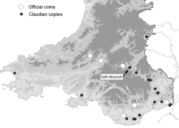
Following the publication of Peter Guest's distribution map of Claudian coins in Wales in 2010Footnote 78 (fig. 9), Davies noticed the ‘string-of-pearls’ effect of such discoveries in the Usk valley and, in particular, a concentration of pre-Flavian coins found by Martin Preece with a metal detector in October 1999 and July 2000 in fields immediately to the west and south of Cefn-Brynich Farm on the north bank of the Usk. These discoveries were reported to the Portable Antiquities Scheme by Philip MacDonald and subsequently published in the Treasure Annual Reports for those years under the designation Llanhamlach.Footnote 79 The coins were identified by Edward Besly at the National Museum and Galleries of Wales and subsequently catalogued as a hoard by Guest and Wells in 2007 (with full references), the find-spot being specified as Cefn-Brynich Farm.Footnote 80 Preece's collection totalled 46 coins: 12 Republican and 5 early Imperial denarii, 34 asses and dupondii, together with 18 unspecified copper-alloy objects. The hoard was subsequently purchased by the Brecknock Museum and Art Gallery.
Location map of south Wales showing Claudian coin finds. (After Guest Reference Guest2010, fig. 1.12 with additions. © Crown: RCAHMW. © Crown copyright and database rights [2015] Ordnance Survey [100022206])

What made this collection of particular interest was the extraordinarily high percentage of so-called Claudian copies (15 in total), which in a Welsh context is highly suggestive of the currency circulating within a military installation of the Claudio-Neronian period. Although there was no antiquarian tradition of a Roman site in the locality, Preece's discoveries convinced Davies that a pre-Flavian fort remained to be discovered at or near Cefn-Brynich. A search of the available aerial photographic coverage of the locality, including those provided by Google Earth, proved negative. On the off chance that the dry conditions of mid-summer might prove productive in terms of grass-mark formation Davies contacted Driver on the last day of July 2013 to suggest a flight over the Cefn-Brynich area should the opportunity arise. On the following day Davies was informed by Driver that he had observed and photographed the cropmarks of what was manifestly part of the ditch system of a Roman fort, not in pasture but in an arable crop, at precisely the find-spot suggested by Davies. The cropmarks were rapidly disappearing following recent rain, with the fields south of the A40(T) being the only ones with ‘responsive’ crops showing archaeological features in the entire Brecon region.
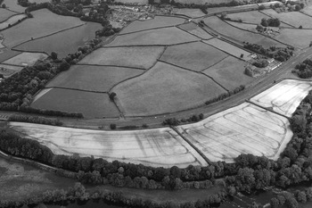
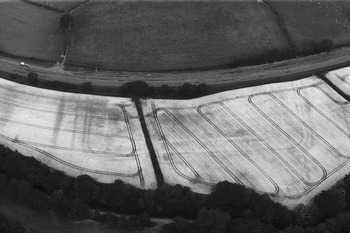
Cropmarks on the aerial photographs (figs 10–11) show the southern third of a large fort with earth and timber defences whose degraded platform is also poorly represented on LiDAR images, though the rampart is barely perceptible on the ground. On the basis of the LiDAR image the fort appears to measure about 260 m north–south by 215 m east–west, encompassing some 5.5 ha overall (excluding the counterscarp; fig. 12). The site occupies ground sloping to the south and is traversed by the A40(T) whose re-engineered course has led to a fall of some 3 m from the road to the field in which the cropmarks appeared. The cropmarks show ditches defining the south-west and south-east corners of the fort with some clarity; the eastern defences comprise a triple-ditch system which may have been continued as far as the south-east corner from where a pair of ditches run south towards the river and clearly define the eastern side of an annexe. The fort's southern defences are unfortunately ill-defined except close to the south-west corner where the ditches appear as a pair, thereafter continuing north to define the western side of the site. Faint traces of two ditches also run south from the south-western corner representing the western side of the annexe, which itself may have been reduced in size by subsequent river erosion. The site of the south gate is unfortunately obscured, while the only discernible feature in the interior is the intervallum road which appears as a parch-mark. Set some 6 m and 25 m from the western defences of the fort two other ditches are visible, the outer being much wider (c. 8 m) than the inner, both sharing the same axis as the western defences of the fort. Extending 120 m west of the outer ditch are the cropmarks of a neatly rounded north-west corner of a single-ditched rectangular enclosure. This may possibly represent part of another annexe, or alternatively a marching or construction camp. The LiDAR also shows a 55-m square earthwork, quite denuded, to the north-west which is presently undated.
General view of the cropmarks of the southern half of Cefn-Brynich Roman fort, showing on 1 August 2013, from the south. The colour bands of the digital aerial photograph have been rebalanced to highlight the poorly defined green-on-yellow/brown cropmarks. (Crown Copyright RCAHMW, AP_2013_5339)

Cefn-Brynich Roman fort. Detail of the fort from the south showing negative cropmarks of the intervallum road and circular anomalies, conceivably the foundations of ovens. (Crown Copyright RCAHMW, AP_2013_5346)

Plan of the Cefn-Brynich Roman fort, showing cropmark features mapped for the southern half of the site and the positions of low, spread earthworks of inner ramparts and the eastern counterscarp as mapped from 2-m LiDAR data. The LiDAR also shows up a 55-m square earthwork on the north-west side which may be a Roman, or later, enclosure. (© Crown: RCAHMW. © Crown copyright and database rights [2015] Ordnance Survey [100022206])

THE SIGNIFICANCE OF THE SITE
Although the precise chronology of the fort at Cefn-Brynich will have to await excavation, the numismatic assemblage from the site is strongly indicative of a pre-Flavian, probably Claudio-Neronian, origin and an occupation which terminates within the first century. Prior to its discovery the most westerly pre-Flavian military installation known in the Usk valley (marching camps excepted) lay at Abergavenny where a fort of uncertain dimensions was certainly in existence by c. a.d. 60 at the latest, the site being thereafter occupied by a succession of auxiliary forts into the second century.Footnote 81 Further north in the middle reaches of the Wye the campaign bases/large forts of the Clyro/Clifford complex represented the only pre-Flavian installations known in this river valley to 2010, the first named being certainly in existence by c. a.d. 60.Footnote 82
The picture has recently been subtly altered by two discoveries, both the result of the perusal of LiDAR images. First, Bryn Gethin recognised a fort measuring c. 175 m by 142 m (enclosing some 2.3 ha) within the 10.5-ha fortification at Clyro,Footnote 83 on a different axis to the campaign base/large fort. Although only excavation can determine the sequence here, there is a strong probability that the new discovery is secondary and represents a post-campaigning or consolidation phase of Neronian or later date. Then, 6 km to the south-west Christopher Martin noted what appears to be a fort of some 1.5 ha on the west bank of the Wye at Glasbury (S0 1830 3912).Footnote 84 The possibility of a Roman road running south-west from Clyro, through Glasbury and Bronllys towards Brecon Gaer (RR63) had already been mooted,Footnote 85 the route broadly corresponding to the modern B4350 and its southern continuation the A470(T). The discovery of the fort at Cefn-Brynich together with the new forts at Glasbury and Clyro, the first named situated close to the junction of the modern Usk valley road (the A40(T)) with the A470(T) heading north, strongly suggests the existence of an early Roman communication route, if not a road, between these major river valleys, with Cefn-Brynich serving as a key site linking two major campaigning routes. This route will have essentially followed the course of the Dulas valley north as far as Glasbury, thence the Wye. Moreover, if a road was already in existence in the pre-Flavian period, then it will have linked Clyro and Cefn-Brynich, and not Clyro and Brecon Gaer as was formerly suggested.
The discovery of the fort at Cefn-Brynich raises a further question about how far west along the Usk valley Roman military operations involving the construction of military bases extended in the pre-Flavian period. Guest's map shows the find-spots of pre-Flavian coinage appearing at the well-known fort at Llandovery in Carmarthenshire, though no structural evidence of a pre-Flavian establishment has been discovered here,Footnote 86 and even as far west as St Brides Bay in Pembrokeshire. It also raises the question of the relationship between Cefn-Brynich and Brecon Gaer. The latter, certainly founded in the early Flavian period, is situated a mere 9.5 km as the crow flies to the west of Cefn-Brynich and probably represents its replacement. While Cefn-Brynich appears to occupy a significant strategic location in respect of pre-Flavian operations in south-east Wales, its replacement by Brecon Gaer suggests that Flavian strategic concerns were quite different to those of the Claudio-Neronian age. However, whether Cefn-Brynich's occupation was simply confined to the Claudio-Neronian period or the fort remained in use into the early Flavian period only excavation can answer.
ACKNOWLEDGEMENTS
The authors are grateful to the landowner, Mrs Prosser of Cefn-Brynich, for her assistance during a visit to the site, to Martin Preece whose original finds first highlighted the archaeological significance of this location and to Peter Guest. The authors are also grateful for information provided by Nigel Blackamore, Senior Curator at the Brecknock Museum and Art Gallery. The hoard is currently accessioned as BRCNM 2001.29. Further information about Cefn-Brynich Roman fort can be obtained from the Royal Commission's online database www.coflein.gov.uk by searching for the site name or the site NPRN 419242.