CEREDIGION
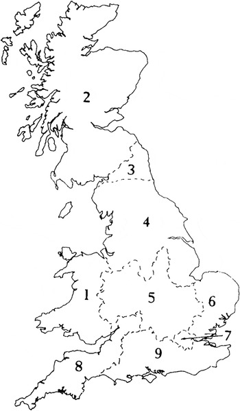
Key to numbered sections of Part I (Sites Explored).

(1) Blaenrheidol, Llys Arthur (SN 78658 82505):Footnote 1 provisional results from a 5 m gridded sampling of the earthwork with a hand-held portable X-Ray fluorescence (pXRF) scanner showed a concentration of lead and other metals within the enclosure, compared to low background levels beyond, very likely originating from anthropogenic activities. These results suggest that metals, particularly lead, were being brought to the site and utilised within the earthwork. The hypothesis behind the work was that the earthwork may have Roman origins, being strategically positioned at the head of a valley pass, surrounded by ore-rich hills, and so well placed to control local mines or process their products.Footnote 2
(2) Llanilar, Pen y Castell trapezoidal enclosure (SN 6299 7468):Footnote 3 a magnetometer survey revealed a clear plan of the enclosure and clarified the position of the main gate for the first time, positioned centrally in the northern (downslope) side. It was possible to make out post-built structures of the gateway within the entrance passage, a causeway through the ditches and heightened magnetic anomalies, potentially dumps of material, in the ditch terminals flanking the gate. The survey showed a well-preserved outer ditch, while darker lines inside the main gate showed the position of an inner revetment wall with deeper layers of material accumulated against it. Disappointingly, no clear structural features or buildings were identified inside the enclosure. The survey did show an apparently random scatter of small iron anomalies less than 0.5 m in size, yielding a high magnetic response. These were clustered towards the south (uphill) side of the enclosure and were scattered further down the slope. There was no way to ascertain, without excavation, whether these anomalies were scraps of smelting debris, buried metal objects, or another more recent metal signature.Footnote 4
DENBIGHSHIRE
(1) Moelfre, Bryn Ewin (SH 9451 7444): a watching-brief along the projected line of the Roman road from Chester to Caernarfon identified no archaeologically significant features.Footnote 5
GWYNEDD
(1) Llanuwchllyn, near Caer Gai Roman fort (SH 87945 31265): a test trench was excavated across the width of a Roman road roughly 250 m south-east of the fort. The upper surface of the road was revealed and a 1 m-wide section excavated along the southern edge of the trench to the upper edge of the ditches, through the agger and displaced agger (probably displaced through ploughing) to the natural deposits. The section revealed that the eastern side of the road and roadside ditch had been truncated by a large ditch. Although this ditch post-dated the road all the finds within the fills of the ditch were Roman, and therefore may belong to a later Roman, or more likely early post-Roman phase after the Roman road had fallen out of use. The ditch may have been used to drain water away from the nearby fort, as the ditch was in line with the former bath-house. Although the ditch heavily truncated the eastern roadside ditch, some clear evidence of the cut remained. The western roadside ditch was largely untouched and contained three fills. A number of pottery sherds were found, mainly within the large ditch cutting the road and roadside ditch; most had rounded edges suggesting that they had been washed down the hill from the fort.Footnote 6
ISLE OF ANGLESEY
(1) Holyhead, Penrhos Leisure Village (SH 2716 8166): an evaluation of 50 trenches over three areas revealed a metalled surface and probable flanking gullies, thought to represent a continuation of a Romano-British trackway identified in a previous investigation. A few sherds of a late Roman black burnished ware jar base, possible oven-lining fragments and cereal remains were recovered from an isolated pit approximately 200 m to the west.Footnote 7
MONMOUTHSHIRE
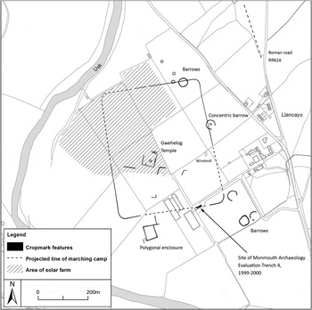
(1) Gwehelog Fawr, Llancayo Farm Roman marching camp (SO 3629 0306) (fig. 2):Footnote 8 further aerial reconnaissance confirmed the line of the eastern defences and allowed a new plan of the site to be completed. The camp as revealed measures 500 m north–south by 400 m east–west, and encloses approximately 20.2 ha.Footnote 9
Llancayo Farm Roman marching camp. (Crown Copyright RCAHMW. © Crown copyright and database rights [2014] Ordnance Survey [100022206])

(2) Monmouth, Church Hall, Overmonnow (SO 50387 12446): an archaeological evaluation produced a fragment of a tegula suggesting the existence of a substantial Roman building in the vicinity. The dating of the pottery recovered, all coarse wares, centred on the third and fourth centuries.Footnote 10
(3) Usk, 33 Old Market Street (SO 3762 0053): a watching-brief indicated that within the area of the small courtyard deposits relating to the Roman period survived toward the east half of the site, overlying natural sandy pink clay. To the west possible Roman deposits had been largely cut away and subsequently backfilled to the formation level for the new building leaving only isolated pockets of clay without any dating evidence.Footnote 11
NEWPORT
(1) Caerleon (Isca), Pillmawr barn (ST 31404 90570): the remains of a building, possibly a barn, apparently destroyed by fire, were recorded in section, the rest of the archaeology having been removed in the distant past. The only dating for these remains was associated with the building's destruction and was a single rim sherd of Roman pottery found sealed inside the collapsed walling and rubble filling the building. The floor here consisted of a thin layer of patchy trodden clay, with charcoal flecks, lying upon the natural bedrock and covered by collapsed walling and a substantial layer of burnt wattle and daub.Footnote 12
(2) Newport, Friars Walk (ST 3125 8790): residual Roman pottery consisting of black burnished ware and South Wales reduced greywares was encountered within later medieval pit and drain features, as well as a buried topsoil deposit. A small group of abraded Roman brick and tile was also recovered from a buried topsoil horizon and from the fill of a post-hole, as well as an early post-medieval cobble surface and cess-pit. A single stone tessera was also recovered from the fill of a late medieval drain and a Sudbrook sandstone quern from the fill of a similarly dated pit. The fortress of Caerleon that lies upstream may be one source, but the presence of pottery, tesserae and a quernstone could indicate an undiscovered settlement closer to the site, near the mouth of the Usk.Footnote 13
PEMBROKESHIRE
(1) Wiston: (a) Roman fort (SN 0254 1844):Footnote 14 a further trench was opened within the fort, revealing further post-holes, pits and the ramparts of the fort. Further pottery analysis by Peter Webster suggests that the fort had been abandoned by a.d. 100.Footnote 15
(b) Romano-British settlement (SN 0270 1847): geophysical survey in fields to the south of the fort indicated an extensive settlement comprising a series of farmstead enclosures roughly aligned along possible trackways and a known Roman road alignment, covering an area of over 10 ha. Four trenches were opened up across a sample of these features which confirmed the presence of the enclosures seen on the survey, as well as the survival of post-holes and gullies suggesting buildings. An area of a possible midden associated with the settlement was identified infilling a low point of the field. Evidence for possible agricultural processing was also recorded in one of the trenches. The pottery recovered was mid-first-century to fourth-century, with a slight hiatus in the early to mid-third century. The pottery assemblage contained few imports, mostly British manufactured wares, which contrasts well with the material recovered from the fort. The discovery of this extensive settlement, which is not a vicus associated with the fort, but a later collection of conjoined enclosures and farmsteads, is the first of its kind identified in this region west of Carmarthen.Footnote 16
POWYS
(1) Beulah, Caerau (SN 9239 5016): further geophysics and evaluations were carried out on features to the west of the main north–south road that bypassed the fort.Footnote 17 Geophysics on a large marching camp showed it to be almost 15 ha in area, with a group of probable ovens set into the inner face of the ditch at its southern corner. A little to the south and some 200 m west of the fort, a sub-rectangular ditched enclosure was found to be comprised of three superimposed practice camps, each measuring c. 65 m north–south by 55 m east–west.Footnote 18
(2) Newtown, Dyffryn Industrial Estate (SO 1234 9193):Footnote 19 a machine-excavated trench revealed a band of gravelly clay make-up with a small area of intact gravelled surface. No dating evidence was recovered but the character of the feature was that of a partially surviving, though truncated, Roman road.Footnote 20
VALE OF GLAMORGAN
(1) Cowbridge: (a) Wayside (SS 98930 74878): a watching-brief revealed a single Roman feature dated to the first or second century, which was excavated.Footnote 21
(b) 18 Westgate (SS 99170 74738): a Roman circular pit probably dated to the second century was partly excavated and recorded. The presence of Roman features at the eastern end of Westgate confirms that Roman occupation extended beyond the core of the known area centred along the northern side of the High Street.Footnote 22
(2) Hensol, land south of Junction 34, M4 (ST 0640 7940): an evaluation comprising six trenches confirmed the presence of a probable late Iron Age to Romano-British farmstead, initially identified by geophysical survey. The features comprised a ditched enclosure with internal features, some potentially structural, and two associated droveways. The small artefactual and ecofactual assemblages comprised pottery tentatively dated as Iron Age; a sherd from a large Roman greyware everted rim jar; fragments of Roman brick/tile; and charred plant remains, including hulled wheat.Footnote 23
(3) Penmark, Kenson Hill (ST 05200 68420): topsoil stripping of the development area failed to locate the cropmark recorded in aerial photographs but confirmed the existence of a Roman site severely damaged by ploughing. Two areas of archaeological interest were identified and excavated. Area A covered some 750 m2 and was centred on the remains of a gully. The full length of the gully and a number of patches of occupation deposits pressed into the limestone bedrock were excavated. The abundant finds of pottery and several coins place the occupation between the second half of the third century and the first half of the fourth century. Area B covered some 20 m2 centred on a large pit to the south of Area A. The pit was partly excavated and revealed several backfilling layers with abundant iron slag and domestic artefacts. The artefact assemblage was similar to that from Area A and it is likely that the features were contemporary.Footnote 24