Foxe Basin is commonly referred to as the center of pre-InuitFootnote 1 populations’ (a.k.a. Paleo-Inuit or Paleo-Eskimo) activities and cultural development and is also known as the Core Area (e.g., Fitzhugh Reference Fitzhugh and Maxwell1976, Reference Fitzhugh1997; McGhee Reference McGhee, Vasari, Hyvarinen and Hicks1972, Reference McGhee and Maxwell1976; Maxwell Reference Maxwell and Maxwell1976; Ramsden and Tuck Reference Ramsden and Tuck2001). The Core Area model maintains that as a result of the region's rich and diverse wildlife, including a large year-round population of walruses, it sustained human populations from the time of Pre-Dorset (an early pre-Inuit group) to contemporary Inuit—that is, for more than 4,000 years (Figure 1; Desjardins Reference Desjardins2013, Reference Desjardins2018; Maxwell Reference Maxwell and Maxwell1976, Reference Maxwell1985). The substantial, stable pre-Inuit populations of Foxe Basin contrast with more peripheral Arctic locales that were periodically abandoned by pre-Inuit peoples (McGhee Reference McGhee, Vasari, Hyvarinen and Hicks1972; Maxwell Reference Maxwell and Maxwell1976, Reference Maxwell1985). The Core Area model also posited a smooth transition from Pre-Dorset to Dorset within the region (e.g., Taylor Reference Taylor1968). The model, however, has not been universally accepted (e.g. Cox Reference Cox1978; Maxwell Reference Maxwell1985; Tuck Reference Tuck and Maxwell1976). Over the past two decades, archaeological research in numerous Arctic locations outside the Core Area has changed our understanding of sites once considered peripheral; sequences have been developed and refined, establishing substantial and continuous occupations in many of these locations (e.g., Appelt and Gulløv Reference Appelt and Gulløv1999; Friesen Reference Friesen2002, Reference Friesen2007; Milne et al. Reference Milne, Park and Stenton2012; Renouf Reference Renouf2011; Schledermann Reference Schledermann1990). Nevertheless, the model has continued to evolve and has figured prominently within Arctic archaeology since its initial proposal (see Murray Reference Murray1996; Ryan Reference Ryan, Friesen and Mason2016; Savelle and Dyke Reference Savelle and Dyke2014).
Site location and pre-Inuit Core Area (outlined on inset).

The results of Savelle and Dyke's (Reference Savelle and Dyke2014) Foxe Basin surveys, which assessed paleodemography based on dwelling feature abundance by elevation on raised beaches, indicate that there is no documented earliest Pre-Dorset or, until now, Early Dorset in Foxe Basin. The results also demonstrated that, contrary to conventional thought, these occupations were not stable but underwent boom (large populations) and bust (small or absent populations) cycles, suggesting that the region was vulnerable to environmental or social stresses, or both, as seen in more peripheral Arctic regions (Dyke and Savelle Reference Dyke and Savelle2009; Dyke et al. Reference Dyke, Savelle and Johnson2011; Savelle and Dyke Reference Savelle and Dyke2002, Reference Savelle and Dyke2009; Schledermann Reference Schledermann1978; Sutherland Reference Sutherland, Grønnow and Pind1996). The cycles were primarily defined by the abundance of short-term dwellings (surface as opposed to semi-subterranean dwellings).
The Dorset period is traditionally divided chronologically into Early, Middle, and Late phases (e.g., Maxwell Reference Maxwell1985); however, archaeologists are still grappling with questions regarding Dorset cultural development, interaction, and transition (Ryan Reference Ryan, Friesen and Mason2016). Particularly salient to our understanding of the three phases is how we define Early and Middle Dorset. Recent research also has demonstrated flaws in the artifact typologies previously used to define these three phases (Desrosiers Reference Desrosiers2009; Desrosiers et al. Reference Desrosiers, Gendron, Rahmani, Arneborg and Gulløv2006, Reference Desrosiers, Gendron, Todisco, Monchot, Rahmani, Bhiry and Houmard2008), and radiocarbon dates from key Early Dorset sites on samples subject to the marine reservoir effect have hampered definition of phase boundaries (see summary in Ryan Reference Ryan, Friesen and Mason2016). As a result, Desrosiers (Reference Desrosiers2009) has proposed an alternative classification based on research in Nunavik, suggesting Early and Middle Dorset be classified together and called Classic Dorset. Excavations at Alarniq and other key Dorset sites will contribute new data that is necessary to redefine the Dorset cultural historical framework and provide a firm chronology for the Dorset cultural phases (see also Desrosiers Reference Desrosiers2009; Desrosiers et al. Reference Desrosiers, Gendron, Rahmani, Arneborg and Gulløv2006). For the purposes of this report, we refer to Early Dorset as the period between approximately 2,500 BP and 2,000 BP (see Helmer Reference Helmer1981, Reference Helmer1991; McGhee Reference McGhee and Maxwell1976; Maxwell Reference Maxwell1985), Middle Dorset as the period between approximately 2,000 BP and 1,200 BP, and Late Dorset as the period between 1,200 BP and 700 BP. We use BP to indicate uncalibrated radiocarbon years before present.
In this report, we provide a new site map and present more details based on surveys and excavations at Alarniq by Savelle and Dyke in 2008 and by Howse in 2015 and 2017.Footnote 2 We also present a new sequence of radiocarbon dates and focus on how these new data change our understanding of the site's occupation, such as indicating that caution should be used when determining fine-grained paleodemography based on feature-level data alone.
History of Research at Alarniq
Alarniq is located on the Melville Peninsula in northern Foxe Basin (Figure 1). It was mapped and excavated by Jorgen Meldgaard in 1954, served as the type site for Dorset culture history (Meldgaard Reference Meldgaard and Wallace1960, Reference Meldgaard and Campbell1962), and was instrumental in the development of Maxwell's (Reference Maxwell and Maxwell1976, Reference Maxwell1985) Core Area model (see Savelle and Dyke [Reference Savelle and Dyke2014] for a history of research in Foxe Basin to 2013). Since Meldgaard's work, archaeological investigations in Foxe Basin have been sporadic (e.g., Desjardins Reference Desjardins2013, Reference Desjardins2018; Rowley Reference Rowley, Fitzhugh, Loring and Odess2002; Rowley and Rowley Reference Rowley, Rowley, Gilberg and Gulløv1997; Savelle et al. Reference Savelle and Dyke2009), however the pre-Inuit occupations in the area are receiving renewed attention with the Foxe Basin Archaeology Project that has resulted in two seasons of excavations at Alarniq and Kapuivik (Jens Munk Island).
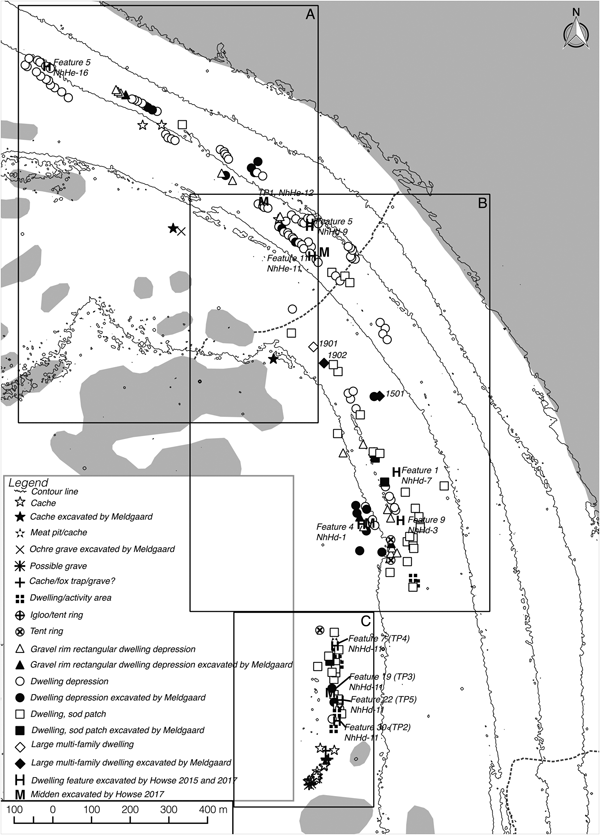
The Dorset occupation at Alarniq extends 5.5 km along a succession of raised gravel beach ridges, ranging in elevation from 8 to 24 m above sea level (asl). It is currently unclear whether all the features at 24 m asl are of Dorset origin or whether a late Pre-Dorset occupation is present (see below). Meldgaard identified 208 Dorset dwelling features at the site, ranging in size from small (typically in the 3.5 x 4.5 m range), presumably single-family dwellings, to large (up to 15.0 x 8.0 m) multifamily dwellings. In addition to identifying dwellings, Meldgaard noted several other types of features, including meat caches and graves, or burials (see Figure 2a). From these latter features, Meldgaard recovered several Dorset human skeletal elements that are exceedingly rare across the eastern Arctic (Lynnerup et al. Reference Lynnerup, Meldgaard, Jakobsen, Appelt, Koch and Frølich2003).
In this area of the Arctic, isostatic rebound has resulted in the uplift of ancient shorelines. Based on the assumption that people tend to build their dwellings on the beach ridge closest to the shoreline, Meldgaard (Reference Meldgaard and Wallace1960) referred to the beach ridges at Alarniq as the “stairway of history.” With this is mind, the artifacts he recovered from the site were used to suggest a gradual development in material culture from the upper beach ridge to the lowest ridges at 8 m asl, representing all phases of the Dorset culture (Lynnerup et al. Reference Lynnerup, Meldgaard, Jakobsen, Appelt, Koch and Frølich2003).
Methods
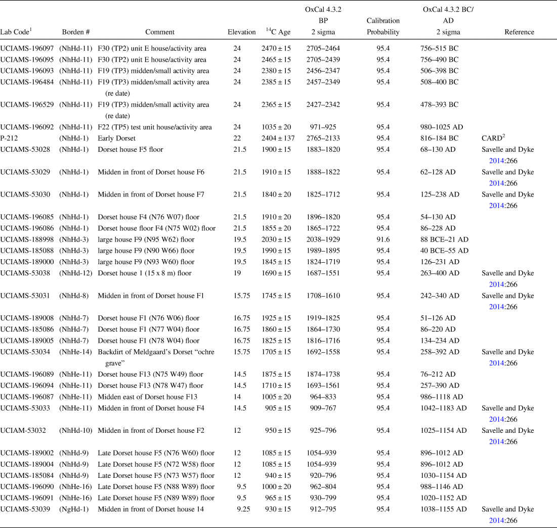
Savelle and Dyke visited Alarniq in 2008 to remap the site and conduct limited test excavations to acquire materials for radiocarbon dating. The changing abundance of dwelling features by beach-ridge elevation was used as a proxy for relative population size and continuity. Savelle and Dyke (Reference Savelle and Dyke2014) noted that while people would not have been constrained to live only at the contemporaneous shoreline, if dwellings were randomly distributed throughout the different beach ridges, they would expect to see little change in the number of features with elevation and no major gaps in their distribution. Further details regarding survey methods and processing of materials for radiocarbon dating are described in Savelle and Dyke (Reference Savelle and Dyke2014), as are the preliminary results. Supplementary data and materials for dating were collected by Howse in 2015 and 2017, when excavations took place and the upper beach ridges at the site were investigated. Feature elevations were measured using a surveying altimeter with the high-tide line as a datum. Note Meldgaard (Reference Meldgaard and Wallace1960) used a level to measure feature elevations, and it is unknown what he used as a datum, thus variation in our methods likely explain the slight discrepancies between our beach level elevations (i.e., we measure the uppermost beach ridge at 24 m asl, and Meldgaard measures it at 22 m asl). The radiocarbon dates were calibrated at 2σ using the program OxCal 4.3.2 (Bronk Ramsey Reference Bronk Ramsey2009). Further, we subdivided the site into a series of subunits based on elevation and probable social subunits, resulting in a new series of Borden designations (as opposed to the original single designation—NhHd-1; Table 1).
Radiocarbon Dates from Alarniq.

1 All dated materials were from Caribou specimens, except for UCIAMS-53059, which was not identified beyond terrestrial mammal.
2 CARD = Canadian Archaeological Radiocarbon Database, www.canadianarchaeology.ca/radiocarbon/card/card.htm.
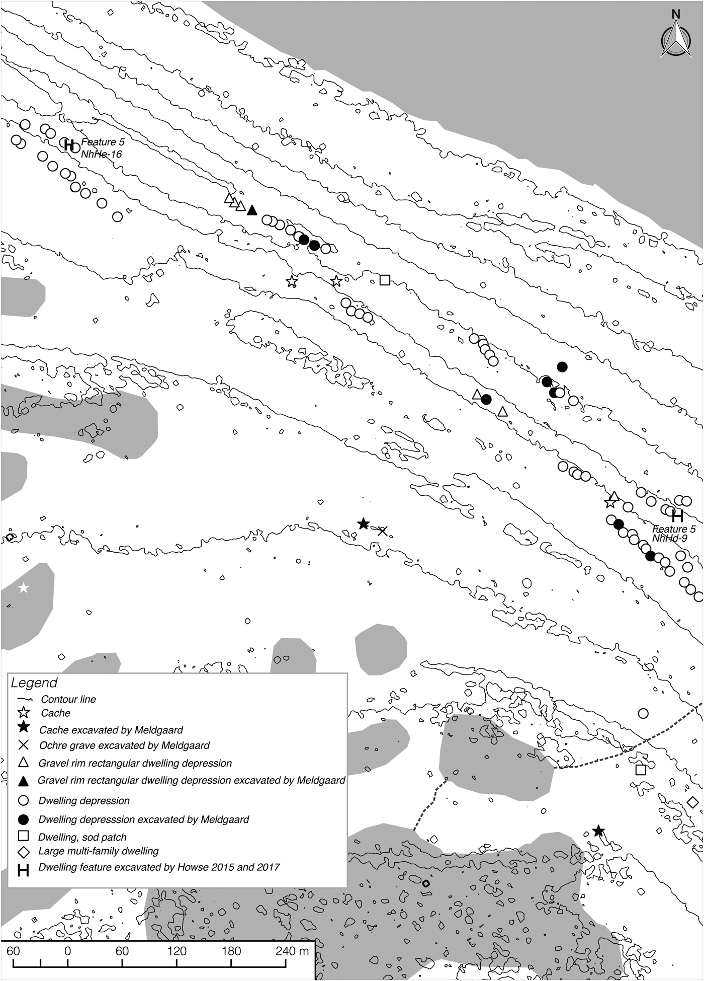
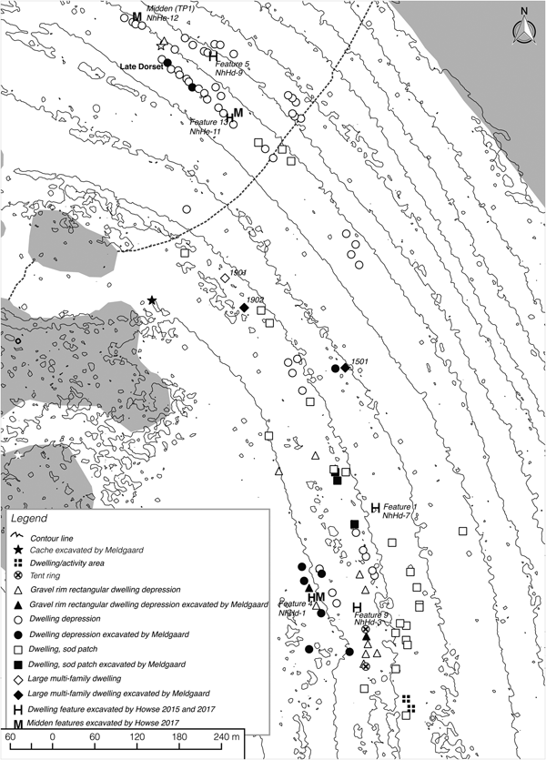
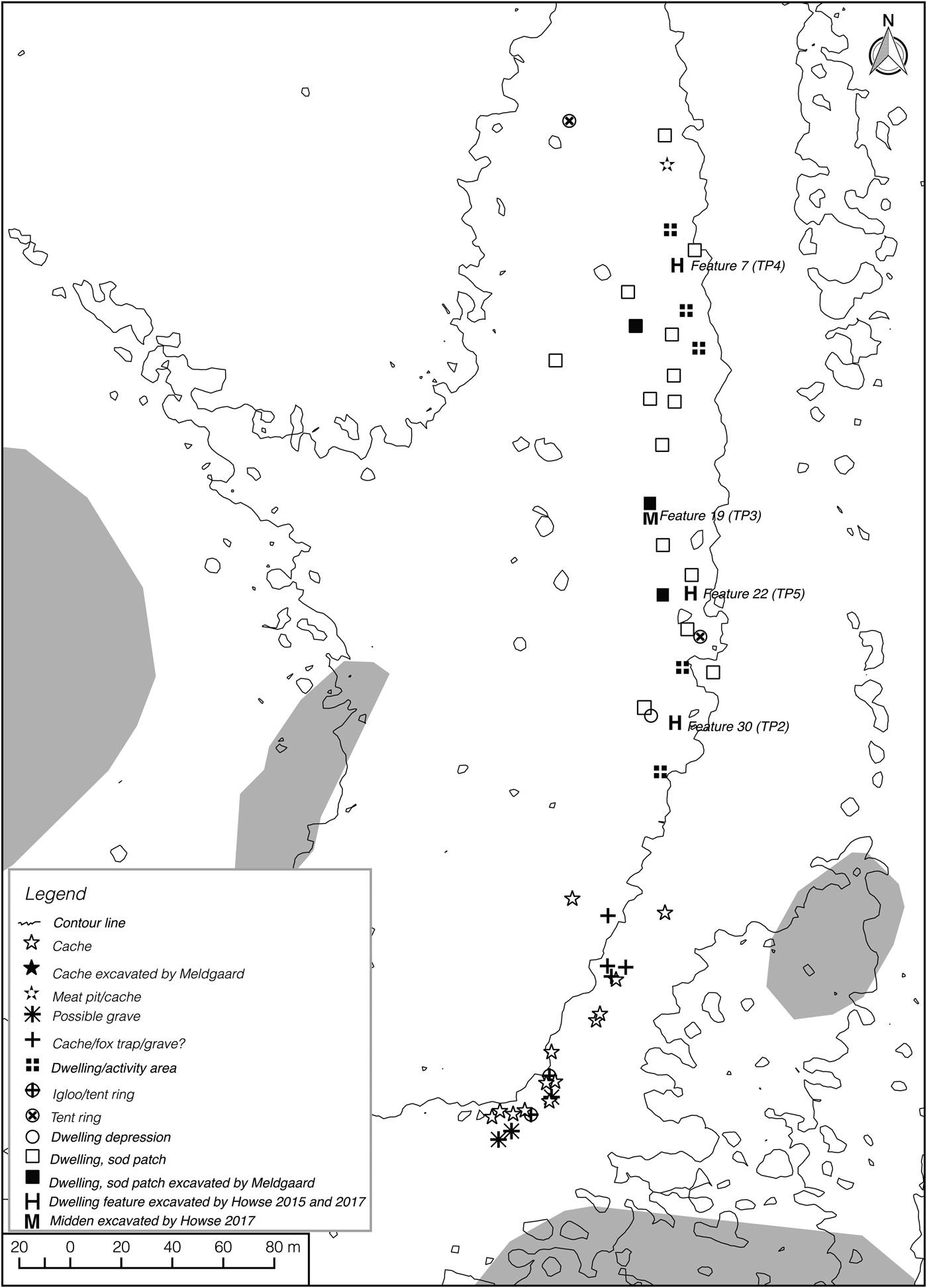
During our surveys, we recognized only 191 dwellings (Figures 2a–d), as compared to the 208 reported by Meldgaard (Reference Meldgaard and Wallace1960). This discrepancy is likely a result of our considering small (1.0 x 1.0 m or less), slight depressions as caches or natural depressions instead of dwellings. Dwellings occur on most beach ridges but typically as clusters and with a noticeable gap at approximately 15 m, indicating the site was probably occupied throughout much of the Dorset period (i.e., from the initial occupations at 24 m asl to terminal Dorset). The majority (185 of 191) of these dwellings appear to be semi-subterranean, suggesting Alarniq was almost exclusively a winter–spring occupation, which is unique among known Foxe Basin Dorset sites, where most sites appear to have been in use during various parts of the year.
Site map based on 2008 survey by Savelle and Dyke and 2017 survey by Howse. Contour lines were generated using a high resolution (2 m) digital elevation model using ArcticDEM (https://www.pgc.umn.edu/data/arcticdem/).

Site map subarea A.

Site map subarea B.

Site map subarea C.

The goal of the 2015 and 2017 fieldwork was to test the boom-and-bust model at Alarniq, examine subsistence-settlement practices, and acquire radiocarbon dates throughout the site.
Results
Site Demography
Pearson's correlation coefficient between beach-ridge elevation and site age at Alarniq is 0.78 (n = 30; p < 0.01), suggesting a positive relationship. Figure 3 presents the number of dwellings per beach ridge at Alarniq and implies there are fluctuations in the frequencies of dwelling features. In particular, a significant decrease in dwelling features occurred between 23.5 and 21.5 m asl, after which there is an increase with dwelling features reaching the highest levels recorded between 20 and 18 m asl preceding another decline. The high correlation between beach-ridge elevation and pre-Inuit site age corroborates Meldgaard's earlier observations (Reference Meldgaard and Wallace1960, Reference Meldgaard and Campbell1962), which have also been identified in neighboring regions (Savelle and Dyke Reference Savelle and Dyke2014).
The number of dwellings per beach ridge at Alarniq (this differs from that published in Savelle and Dyke Reference Savelle and Dyke2014, which also includes dwellings from Pinger Point).

Site Chronology
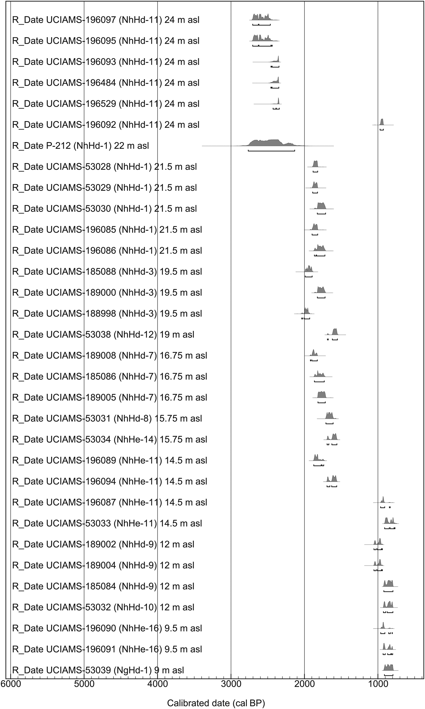
The new radiocarbon sequence for Alarniq indicates it was occupied between approximately 2,700 and 800 cal BP (Table 1 and Figure 4). This is currently based on 30 radiocarbon dates obtained on caribou or terrestrial mammal (most likely caribou) bone collected from various features across the different beach ridges (Figure 4; Table 1; Savelle and Dyke Reference Savelle and Dyke2014). Additionally, one conventional radiocarbon date of 2,765 to 2,133 cal BP was obtained on caribou by Meldgaard in 1956 (P-212; Table 1). Although we recognize that calibrated dates are not precise, following the general standard convention, we use the highest probability in discussing the overall trends from earliest to latest.
Calibrated radiocarbon dates from Alarniq. OxCal v4.3.2 Bronk Ramsey (Reference Bronk Ramsey2017); r:5 IntCal 13 atmospheric curve (Reimer et al. Reference Reimer, Bard, Bayliss, Beck, Blackwell, Ramsey and Buck2013).

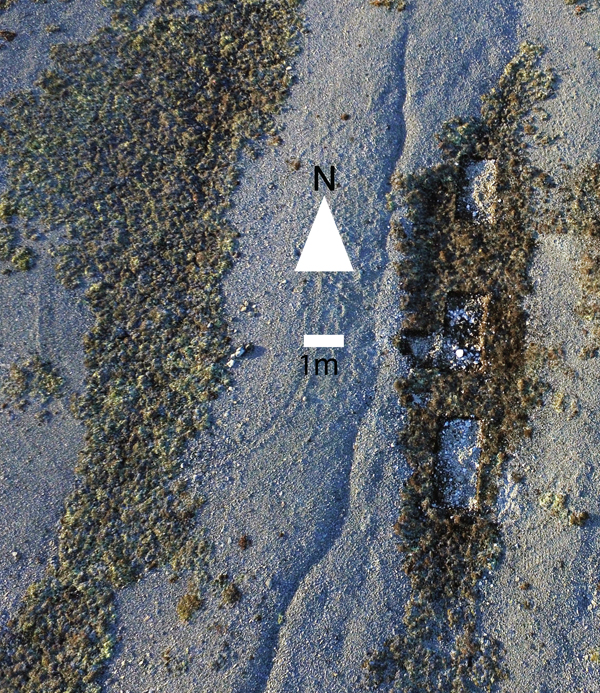
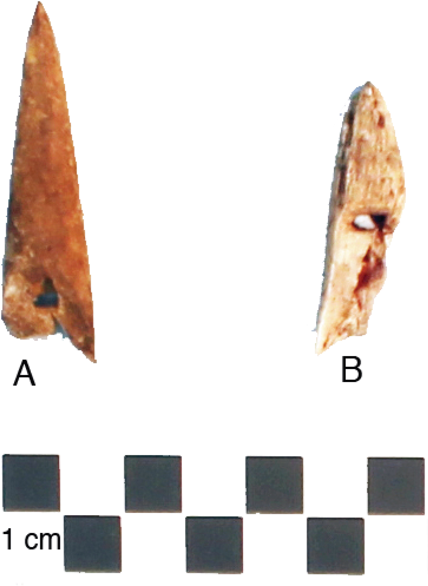
As expected, the earliest dates we have for the site are from two features, a midden (Feature 19) and a dwelling (Feature 30) located on the highest beach ridge in the area, which is 24 m asl (Figure 2d). These dates range between 2,705 and 2,347 cal BP (Table 1). Notably, 17 of the 25 dwelling and possible dwelling features on this beach ridge are distinct from the majority of those found across Alarniq in terms of shape and orientation (Figure 5). They consist of long, narrow, sod-covered patches associated with scatters of lithic artifacts and faunal material and were often positioned in natural depressions along the beach. Eight had obvious hearth features within or slightly adjacent to the sod. Four features in this area were tested in 2017. Initially, there was some suspicion they represented a Pre-Dorset occupation because of their distinct surface appearance and early dates; however, two Dorset-type harpoon heads (Tyara sliced and a self-bladed; Figure 6) were excavated from these features and indicate they were Dorset in origin. Thus far, the radiocarbon dates and Dorset harpoon heads in these features provide the only solid evidence of Early Dorset occupation of northwestern Foxe Basin.
Aerial photo of a dwelling, Feature 30, NhHd-11, located at 24 m asl. Photograph by Lesley Howse.

Photograph of Dorset type harpoon heads excavated from NhHd-11. A) Tyara sliced harpoon head, Feature 30, and B) Self-bladed harpoon head, Feature 19. Photograph by Lesley Howse

The new dates also show two important gaps in the radiocarbon sequence. The first is between 2,400 and 2,000 cal BP. While this time frame may correspond with the occupation that occurs between 23.5 and 21.5 m asl, for which radiocarbon dates are lacking, this does not appear to have been a significant occupation. The features are concentrated at the southern end of the site (Figure 2d, features located to the right of the contour line), and only two of these features were possible dwellings. Unique at the site, they consisted of circular arrangements of boulders with defined benches, possibly the remnants of igloos or tent rings.
A second gap in the radiocarbon sequence occurs between 1,550 and 1,000 cal BP and presumably corresponds with occupations between 14 and 13 m asl (Figure 2c). The numerous dwelling features occurring on these beach ridges have not yet been thoroughly radiocarbon dated. Though one feature was tested in 2017, unfortunately, no caribou bone or other terrestrial mammal remains were recovered. Therefore, it is unclear whether the lack of dates between 1,550 and 1,000 cal BP indicates the site was not occupied during this period or a sampling issue.
Most revealing about this new series of radiocarbon dates is that it shows overlap between site age and beach ridges located within 5 to 7 m of each other that were potentially occupied during the same period. Since the calibrated radiocarbon dates include age ranges between 60 and 300 years, it is not possible to further determine the degree of overlap between the timing of these occupations. Regardless, the dates we obtained suggest the dwellings between 14.5 and 21.5 m are the same general age. Hence, paleodemography at the site is less straightforward than suggested by the number of features per beach ridge.
Radiocarbon Dates and Dwelling Reuse
Of the six dwelling features that have been completely excavated at the site (Figure 2a–d), the radiocarbon dates from four suggest they were reoccupied or rebuilt over time (Table 1). This includes a large Middle Dorset multifamily house at 19.5 m asl (excavated in 2015), which appears to have been at least partially reoccupied for two centuries (Howse Reference Howse2016). Notably, this also includes Feature 13, NhHe-11, and Feature 5, NhHd-9, located on Alarniq's lower beach ridges (Howse Reference Howse2018; Figure 2c), suggesting reoccupation of the features did not just occur on the upper beach ridges. Feature 4, NhHd-1, located at 21.5 m asl, appears to be two separate dwellings that slightly overlap (Figure 7) and is the only excavated dwelling feature with stratigraphic deposits and corresponding radiocarbon dates that indicate reuse over time. Further, the radiocarbon dates show that dwelling features located on one beach ridge, including those located nearby, were occupied during different periods. For instance, at 24 m asl, Feature 22 dates to the Late Dorset period and is located proximate to Feature 30, which dates to the Early Dorset period (Figure 2d; Table 1). A similar pattern is found on the beach ridge at 14.5 m asl where a Late Dorset midden is located in the same cluster of houses as Feature 11, a Middle Dorset dwelling (Figure 2c; Table 1).
Plan of Feature 4, NhHd-1.

Discussion
The new radiocarbon sequence indicates that dwellings between 14.5 and 21.5 m are the same general age. It appears that there was little shoreward shifting of dwellings until relative sea level (rsl) had fallen below 16 m. Hence, paleodemography at the site is less straightforward than suggested by the number of features per beach ridge. The continued occupation of the higher levels may be explained in a number of ways. First, shoreline tracking may not have been forced as strongly by rsl change in winter village sites because of the value of existing infrastructure. Second, a certain amount of freeboard (height above crest of the active beach) is essential, and some elevation improves a site's value as a gaze across sea ice. Third, the actual shoreline on a gentle slope is a very inconspicuous and unimportant feature in the winter when land and sea ice are blanketed with snow. Fourth, not every 1 m increment of rsl fall results locally in new space that can be occupied. Livable space is provided once the new beach has built a crest higher than storm tides, typically 1 to 2 m above quiet water high tide.
Additionally, we suggest seasonality has played a significant role in the settlement patterns at the site. During the warm season, Dorset were presumably highly mobile, using the shore fast ice/beach (or water?) for travel, and camping immediately above the active beach (i.e., on the first dry relict beach). In contrast, the winter settlement mobility is highly restricted, and dwellings are more permanent, increasing their value and their chance for reuse. The data collected in the two recent field seasons at Alarniq support this theory. It appears that there is more of an emphasis on ideal dwelling construction locations, and thus more variation between the elevation-age relationship, as is the case with many Thule Inuit winter villages. Altogether, this suggests a relatively high degree of site fidelity. Whatever the reasons, the data indicate that when analyzing Dorset winter villages such as Alarniq, caution should be used when estimating paleodemography based on feature elevation alone.
Importantly, the lack of a strict correlation between feature elevation and age is bound to affect the current Dorset artifact typology that has largely developed using the material Meldgaard recovered at Alarniq (see Maxwell Reference Maxwell1985). Desrosiers and Gendron (Reference Desrosiers and Gendron2004) have previously pointed out that there are substantial problems with Dorset harpoon head typology, since the Tyara harpoon heads, traditionally interpreted as marking the Early Dorset period, are now shown to date to the Middle Dorset period at the Tyara site. This problem has been identified at Alarniq, where Tyara harpoon heads as well as a Nanook Wasp Waist type, which has been associated with the Middle Dorset period (Maxwell Reference Maxwell1985; Taylor Reference Taylor1968), were recovered from the same feature (Feature 9, NhHd-3); similarly, the radiocarbon dates at Alarniq clearly associate the Tyara harpoon heads with both the Early and Middle Dorset periods (Howse Reference Howse2016, Reference Howse2018). It is expected that future analyses will reveal more artifact categories that have been incorrectly assigned.
Conclusion
The new data from Alarniq questions our previous understanding that populations fluctuated throughout the site's occupation and of the elevation-age relationship. Whether there were booms and busts in population, as has been seen elsewhere (Savelle and Dyke Reference Savelle and Dyke2009; Savelle et al. Reference Savelle, Dyke, Whitridge and Poupart2012), remains unclear. It now seems that seasonality may be a key factor in where Dorset constructed their winter–spring dwellings. It is also clear that at Alarniq, Dorset did not consistently build their dwellings as close as possible to the shoreline. This, along with the potential reoccupation of the features noted, supports the suggestion that beach-ridge chronology alone does not necessarily predict relative feature age.
Work at Alarniq continues to redefine our understanding of Core Area populations and the Core Area model itself. Despite the lack of published data from Foxe Basin, Dorset sites outside the region have continually been defined as peripheral sites. It seems, however, that our understanding of the nature of the pre-Inuit occupations in this region is still in its infancy. Since Alarniq appears to have been occupied throughout much the Dorset period, continued work at the site will provide the opportunity to reassess the definition of Early and Middle Dorset and define new artifact typologies within a solid site chronology. Furthermore, the results from Alarniq attest to the importance of obtaining radiocarbon sequences throughout Foxe Basin sites to clarify population fluctuations within the region and the area's importance within the larger Dorset cultural sphere.
Acknowledgements
This research was financed primarily through a SSHRC Insight grant to Savelle and Dyke. Howse received additional financial support from the Nunavut Department of Culture and Heritage (DCH), the Northern Scientific Training Program, and the Inuit Heritage Trust. She is grateful to McGill University and the Canadian Museum of Nature (especially Scott Rufolo and Kamal Khidas for support and facilities). She is also very grateful to the Municipality of Igloolik, Igloolik Hunters and Trappers Association, Inuit Heritage Trust, Qikiqtani Inuit Association, and DCH for their gracious support of the fieldwork. We extend particular thanks to the Mikki and Kadlutsiak families and to the 2008, 2015, and 2017 field crews. Finally, we thank Adam Pollock for producing the site location and site overview maps and Pierre Desrosiers for providing the French abstract. All permits were granted by the Government of Nunavut. The 2008 archaeology permit was granted to James Savelle. The 2015 and 2017 archaeology permits were granted to Lesley Howse (2015-33A; 2017-15A).
Data Availability Statement
Data from the 2008, 2015, and 2017 field seasons are on file with Inuit Heritage Trust and the Government of Nunavut, Iqaluit. Archaeological materials collected during the 2015 and 2017 field seasons are currently stored at the Canadian Museum of Nature, Ottawa, and that collected during the 2008 field season is stored in the Archaeology Lab, Anthropology Department, McGill, Montreal.
Supplemental Materials
For supplementary material accompanying this paper, visit https://doi.org/10.1017/aaq.2018.92
Supplemental Figure 1. Profile of Feature 4, NhHd-1.