NORTHUMBERLAND
(1) Woodburn, outside Risingham Roman fort: a hoard containing 24 dupondii and/or asses and seven artefacts was reported to the Portable Antiquities Scheme (PAS) as Treasure.Footnote 36 The coins range in issue from Nero to Antoninus Pius, some originally concreted together. The objects consist of a key, a phallic pendant, a disc brooch, two pelta-shaped mounts, a button-loop toggle (all in copper alloy) and a circular lead object. The composition of the objects indicates that the hoard has a military character and that it was deposited c. a.d. 154–61.Footnote 37
CUMBRIA
(1) Westward: a denarii hoard of 27 coins of emperors from Nero to Marcus Aurelius (as Caesar) and probably deposited around a.d. 140–44 was reported as Treasure via the PAS.Footnote 38
(2) Ravenglass (SD 0877 9599–0857 9613): test pitting and trial trenching north of the Roman fort found evidence for occupation continuing at least 280 m from the fort.Footnote 39 Occupation deposits, cobble surfaces, stone-lined channels and possible sill walls suggest intense occupation, mostly industrial in character. One test-pit unearthed a gravel surface over cobbles, with a bedding of large granite boulders; this is probably part of the main road north. The occupation was presumably concentrated along the north road, but also extended west as far as the river Esk.
(3) Muncaster, Muncaster Castle (SD 1029 9638): trenching in 2018 over the site of a Roman inscription found in 2017Footnote 40 showed that the inscription lay within an 18th- to 19th-century rubble deposit associated with landscaping of the castle grounds.Footnote 41
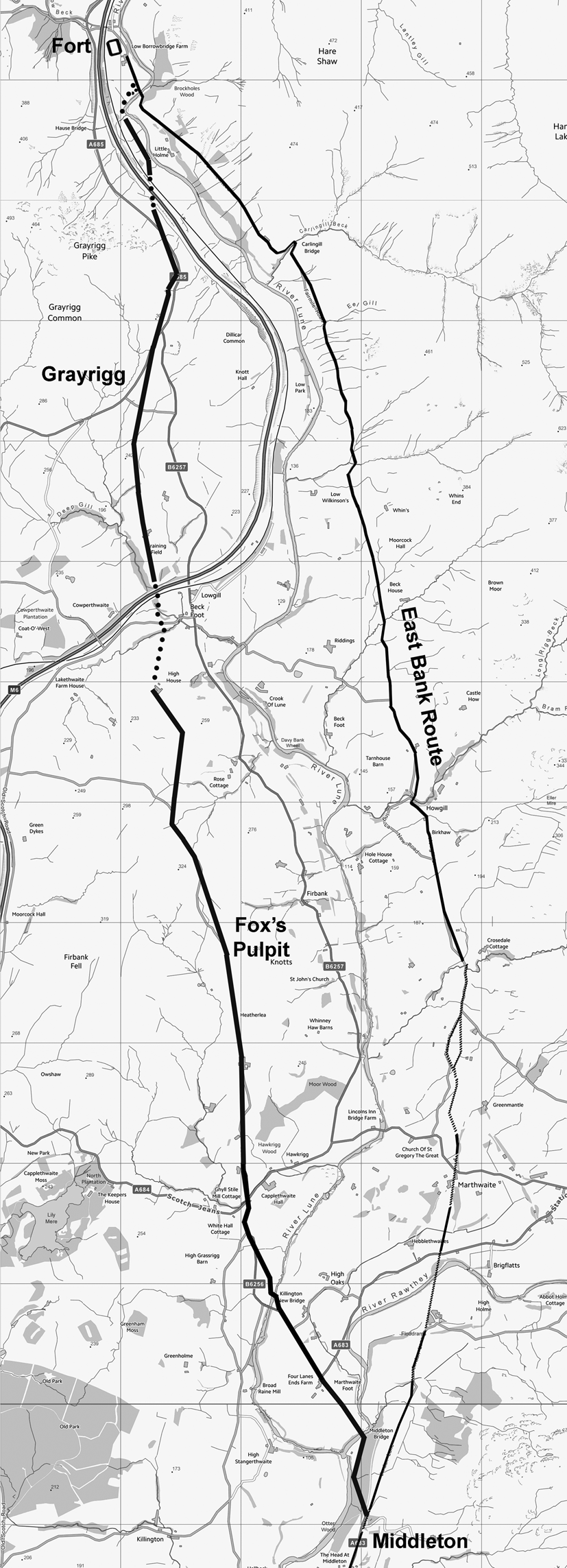
(4) Middleton (to Low Borrowbridge), a second Roman road: a previously unknown Roman road has been detected by LiDAR on the west bank of the river Lune, from Middleton to Low Borrowbridge (fig. 4).Footnote 42 The road left the previously known Roman road at Middleton, crossing the river Rawthey at Middleton Bridge (SD 63000 89750), then crossing the river Lune 100 m north of Killington Bridge (SD 62273 90903). Further stretches of agger are detectable beyond Fox's Pulpit (SD 61827 93897), High House (SD 61280 95917) and Graining Field Farm (SD 61205 97233), and west of Dillicar Knott, Grayrgg (SD 61147 98157); it descends into the Lune gorge following the west bank of the Lune to the fort. The chronological relationship of the two roads is uncertain; while the western route appears to branch off the eastern road, the western route is hillier and thus harder to traverse.
Middleton: the route of the newly discovered Roman road on the west bank of the river Lune, with the known road east of the Lune also shown. (OS Opendata base mapping)

(5) Tebay: a hoard of 56 nummi issued from the reign of Constantine I and deposited c. a.d. 333–35 was reported to the PAS as Treasure. The coins were associated with a waterlogged fragment of textile.Footnote 43
COUNTY DURHAM
(1) Sedgefield, East Park (NZ4353 5290): the first season of a new campaign of excavation at this large village/small town was undertaken in 2019 as one of a range of archaeological projects in the Brightwater Landscape Partnership scheme supported by the National Lottery Heritage Fund.Footnote 44 One of the rectilinear enclosures at the southern end of the settlement and west of Cade's Road was partially explored at the point where it coincided with a linear feature more than 500 m long which crosses the area on a north-west–south-east alignment and continues outside the area in both directions. Thought to be either pre- or post-Roman, the linear feature was proven to be contemporary with the Roman settlement. No more than 1.5 m wide and deep, it was not defensive and seems unlikely to be for drainage. It possibly constituted the formal boundary of the settlement for a time. It was subsequently filled in and succeeded by the enclosure, which may represent an expansion of the settlement beyond its original limits in the later second century. Two cremation burials were found nearby.
(2) Binchester (NZ 2102 3134): investigation of the area immediately in advance of the north-eastern gate of the Antonine fort continued in 2019.Footnote 45 The existence of a ‘bypass road’ branching off from Dere Street and skirting the north-eastern side of the fort was confirmed. The road exiting the north-eastern gate continued beyond the ‘bypass road’ forming a crossroads with it. A succession of slightly built structures of second- and third-century date was recorded. A section across the inner ditch of the Flavian fort was excavated, revealing it to be approximately 5 m wide and 2.5 m deep with evidence of a re-cut following a considerable accumulation of silt.
NORTH YORKSHIRE
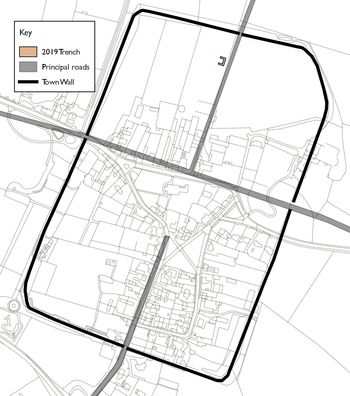
(1) Aldborough, north-east of the village (SE 4068 6666): a C-shaped excavation trench measuring 10 by 14 m in maximum length and width was excavated in an area in which 1924 excavations identified the remains of a structure and recent geophysical survey identified the course of a Roman street (fig. 5). The excavations confirmed activity from the Roman period, provisionally dated across seven periods. Period 1, mid- to late second century, had evidence for a workshop/smithy evidenced by a stone-built furnace, small pit, an infant burial, a timber beam-slot and a series of surfaces composed of alternating lenses of coal, ash, slag and sand/clay debris. Period 2, later second century, saw the replacement of the workshop with a timber-built structure. Period 3, mid-third century, saw the raising of ground level and construction of a stone building, with associated floor levels, built gable-end towards the road. Period 4, fourth to fifth century, saw the laying of a series of surfaces, including well-laid cobbles and more mixed surfaces containing reused architectural stones. Period 5, fourth to fifth century, consists of a possible timber-framed building with stone footings, associated with a substantial bone-rich midden that included off-cuts of antler. Period 6 was attributed to a series of post-holes that may or may not relate to the Period 5 structure(s), as associated medieval pottery may have been redeposited due to animal burrowing. Period 7 identified areas associated with the 1924 excavation. The excavations suggest that this northern part of the town may have been associated with production and/or storage, and that occupation and activity continued into the late Roman period and potentially into the post-Roman period.Footnote 46
Aldborough: location of the 2019 trench in relation to the modern village, the Roman town wall and the principal roads of Isurium Brigantum.

(2) Malton, Roman fort, extramural settlement (SE 792 718): continuing work has investigated development outside the fort's northeastern gate, to either side of the road leading from the gate. To the southeast, towards the river Derwent, multiple phases of structures and activity have been identified, with the sequence commencing with an undated building evidenced by stone-packed post-holes and beam-slots, which was succeeded by a stone-paved roadway. This area also had a high-status late Roman domestic building with multiple phases of activity. Above the collapsed remains of this building was a layer of soil formation, followed by a very late or sub-Roman stone platform, itself consisting of many phases of construction. Evidence for a timber-framed building was found on the surface of the platform. Additionally, a late boundary wall with an apsidal addition was dated contemporary to the stone platform. To the northwest of the road, a strip building was excavated. It was found to have a neonatal burial under its threshold and a backyard space with evidence of intensive use. Further northeast, a substantial, rectangular masonry foundation was inserted into the hillside; the use of one end of the structure as a granary was evidenced by the presence of sub-square stone-built pillars. A possible corn-drying oven was excavated at the opposite end of the building. To the northeast of this large structure, a stone-lined drainage system was encountered, which also incorporated a stone-built kiln.Footnote 47
(3) Well, Bedale Road (SE 26623 81943): a watching-brief and limited excavation identified a substantial stone-built rectangular structure, with dispersed tiles indicating a tile roof, and a pottery dump set against the external wall of the structure containing sherds of vessels dating to the third and fourth centuries. A fragmented quern, probably dating to the mid-third century or later, was incorporated into the top-surviving course of the building's stone fabric.Footnote 48
(4) York, Dunnington: a hoard of seven denarii issued by emperors from Trajan to Septimius Severus and deposited c. a.d. 194 was reported to the PAS as Treasure.Footnote 49
(5) York, Wheldrake: a hoard consisting of seven siliquae and a folded fragment of a silver vessel, deposited no earlier than c. a.d. 395–402, was reported to the PAS as Treasure. The siliquae were minted under the houses of Constantine, Valentinian and Theodosius. The folded sheet of silver weighs 25.2 g and its outer surface bears a partial double-banded incised ring enclosing the engraved letters AL[ ]SA.Footnote 50
EAST RIDING OF YORKSHIRE
(1) Elmswell: metal-detecting found two denarii of Vespasian, dating to a.d. 73, which are considered part of the hoard of 16 denarii reported in 2016. The deposition date of the hoard is a.d. 80 or later.Footnote 51
(2) Rudston: a hoard of eight clipped siliquae minted by the house of Theodosius was reported to the PAS as Treasure.Footnote 52 The hoard was deposited no earlier than c. a.d. 395–402.Footnote 53
DONCASTER
(1) Sprotborough: a denarii hoard of 33 coins issued by emperors from Nero to Antoninus Pius, deposited c. a.d. 148–61, was reported to the PAS as Treasure.Footnote 54
(2) Norton: a scattered hoard consisting of 1,055 denarii and one radiate issued from the reign of Mark Antony to Severus Alexander, deposited c. a.d. 231, was reported to the PAS as Treasure.Footnote 55
(3) Tickhill: a further 19 nummi dating to the reigns of Constantine and his son were added to previous discoveries of a hoard from the same location, deposited c. a.d. 355, and reported to the PAS as Treasure.Footnote 56
(4) Wath: two heavily clipped siliquae issued by the house of Theodosius and deposited no earlier than c. a.d. 395–402 were reported to the PAS as Treasure.Footnote 57
LANCASHIRE
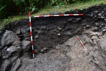
(1) Lancaster, Hillside (SD 47275 61925): a ground-penetrating radar survey undertaken by RSK Environmental for Lancaster and District Heritage Group (LDHG) indicated several anomalies, and two trenches were excavated at the northern end of Hillside, west of the Roman forts outside the area of the scheduled monument, followed by the excavation of two further trenches (fig. 6).Footnote 58 Residual Roman ceramics were recovered from Trench 1 (8 by 2 m, on a north–south alignment), though all other deposits related to the former Lancaster Royal Grammar School (née Free School, c. 1469–1853). Trench 2 (2 by 2 m, with a 1 by 1 m extension), outside the school footprint, revealed a section of a Roman rampart cut by a small portion of a building, evidenced by an opus signinum floor, with both the rampart and building probably relating to the first-century fort. Subsequently, these features were cut by a ditch, probably belonging to the second-century fort. The ditch fill included an assemblage of bird and fish bone, and pottery of second- to fourth-century date.
Lancaster, Hillside: partial section through ditch, which cuts an opus signinum floored building and rampart material (right) (1 m and 500 mm scales).

(2) Ribchester, Lower Alston Farm (SD 6490 3477): a watching-brief recovered abraded Roman and medieval pottery and a small assemblage of chert or poor-quality flint thought to date to the later prehistoric era.Footnote 59
GREATER MANCHESTER
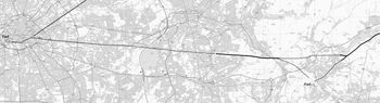
(1) Manchester, Roman Road from Manchester to Melandra Castle: examination of LiDAR and aerial photographic images indicates a direct route from Manchester to the Longdendale valley, passing 1.6 km (1 mile) north of Melandra fort (fig. 7). A Roman agger can be seen north of Matley Lane (SJ 96900 967734), which projects westward and aligns with Hooley Hill (SJ 92272 97112), on old road in Audenshaw and Ashton Old Road (SJ 89861 97344). Eastward from Matley, an old cutting across the hill (SJ 98302 96612) between Harrop Edge Road and Matley Road continues the line. A road agger was recently discovered via LiDAR in the Longdendale valley and by Bottoms Reservoir, Tintwistle (SK 02844 96718), an apparent junction between the main road and a link road to the fort of Melandra.Footnote 60
The Manchester to Longdendale valley and Melandra Castle Roman Road. The probable link roads to Melandra fort are also indicated. (OS Opendata base mapping)

NORTH LINCOLNSHIRE
(1) Winteringham: two denarii of Septimius Severus and Elagabalus, deposited c. a.d. 218–22, were reported to the PAS as Treasure.Footnote 61
(2) Roxby cum Risby: two denarii of Diva Faustina I and Marcus Aurelius issue were reported as Treasure to the PAS.Footnote 62
LINCOLNSHIRE
(1) Riby: a hoard of 776 radiates issued from the reigns of Gordian III to Carausius, deposited c. a.d. 286–93, was reported to the PAS as Treasure.Footnote 63
(2) Riseholme: two hoards dating to the late fourth century were reported to the PAS as Treasure. The smaller hoard consists of 28 nummi with coins minted by the houses of Constantine, Valentinian and Theodosius, and was deposited c. a.d. 378–83. The larger hoard consists of 40 nummi with issues of the houses of Constantine and Theodosius; it was deposited c. a.d. 388–93 and reported with two fragments of greyware.Footnote 64
(3) Bardney area: a hoard of 66 siliquae, some clipped and others incomplete, minted under the houses of Constantine, Valentinian and Theodosius and deposited no earlier than c. a.d. 395–402 was reported to the PAS as Treasure.Footnote 65
(4) Rauceby: a stone-lined pit containing two hoards was reported to the PAS as Treasure. The larger hoard, consisting of two radiate coins and 3,097 nummi issued between the reigns of Gallienus and Constantine I, was placed in a pot in the centre of the pit. The second hoard was smaller, placed to the side in the pit and consisted of ten radiate coins issued from the reigns of Gallienus to Carausius. On the basis of the date of the latest coin, the hoards were deposited c. a.d. 307–08.Footnote 66
(5) Temple Bruer: a hoard of 16 denarii and one sestertius issued by emperors from Vitellius to Caracalla and deposited c. a.d. 203–05 was reported to the PAS as Treasure.Footnote 67
(6) Londonthorpe and Harrowby Without, Harrowby Lane, Alma Park (SK 94104 71992 to SK 94217 36243): evaluation of 134 trenches and subsequent excavation of 17 separate areas was undertaken as part of the first phase of mitigation for the Lincoln to Grantham Resilience Pipeline route. Evaluation revealed extensive limestone quarrying undertaken near Ermine Street in one location, while a Romano-British trackway/hollow way was identified elsewhere. In Welby (Area 9), a Bronze Age barrow ditch was truncated by Roman ditches, with the remains of a settlement abandoned in the late Iron Age or early Roman period to the north of this. At another site in Welby (Area 10) an extensive enclosure system was identified via geophysical survey, probably from a late Iron Age or early Roman settlement. Excavation here revealed a partially industrialised area of the settlement. Small stone-lined flues believed to be for drying pottery prior to firing were found along with a small kiln of early Roman (pre-Flavian) form that produced wine strainers and cheese presses. Human skeletal remains, of probable Roman date, were found buried to the north-east of the kiln and an undated cremation was excavated at the southern end of the site. Excavation at Greetwell (Area 13) identified a significant Roman limestone quarry, a potential source for building stone. The northern part of a site at Canwick (Area 14) revealed ditches and several large stone-quarry pits, which produced artefacts of late Iron Age and Roman date. The southernmost quarry produced artefacts of late fourth-century date, including a nail cleaner strap end. A probable large Roman quarry pit was found in Navenby (Area 16), while excavation at Wellingore (Area 17) revealed two ditches, agricultural furrows and a large undated quarry pit alongside Ermine Street.Footnote 68
(7) Deeping St James, Linchfield Road (TF 1472 1085): evaluation revealed ditches containing small amounts of Roman pottery, possibly relating to putative Iron Age or Romano-British enclosures and field boundaries recorded in aerial photographs to the north. The ditches are broadly aligned with the cropmarks, but both share a common alignment with the post-medieval and modern field boundaries and therefore cannot be conclusively dated.Footnote 69
(8) Sutton St Edmund: two denarii dating to a.d. 190–92 and issued by Commodus were reported to the PAS as Treasure.Footnote 70