INTRODUCTION
Human settlements have existed in the Himalayas for thousands of years. However, it is only in the last hundred years or so that human intervention in the Middle Hills has taken place on a large scale (Moench & Bandyopadhyay Reference Moench and Bandyopadhyay1986; Singh Reference Singh1998; Carpenter Reference Carpenter2005; Subedi Reference Subedi2006). The Middle Hills form a central belt of mountains ranging from 1000 to 3000 m altitude, running alongside the high Himalayas in a north-western to south-eastern direction, constituting 30% of the surface area of Nepal, and the area is densely populated by subsistence farmers. The human population in Nepal dramatically increased from c. 3.6 million in 1900 to 26.6 million in 2010 (CBS [Central Bureau of Statistics] 2011). Coupled with political instability and changes in forest policy, this led to increased pressure on forest resources. During the 1970s and 1980s, Himalayan forest degradation led to the prediction that no trees would be left in the Himalayas by the year 2000, and ensuing debate (Eckholm Reference Eckholm1976; Thompson & Warburton Reference Thompson and Warburton1985; Ives Reference Ives1987, Reference Ives2004; Ives & Messerli Reference Ives and Messerli1989). In response to the severe deterioration of the state controlled forests and the grave environmental degradation, forest management was handed over from state to community control (Gilmour & Fisher Reference Gilmour and Fisher1991) and the concept of community forestry (CF) management emerged in the Nepalese Himalayas (Acharya Reference Acharya2002). From 2.3% per annum in the Hills between 1978 and 1994, deforestation declined to 1.4% between 2000 and 2005 (DFRS [Department of Forest Research and Survey] 1999a , b ; Baral et al. Reference Baral, Sah, Sherpa, Paudyal, Oli and Dhungana2008). However, deforestation and forest degradation are still of serious concern, the latter being considered more important than the former. Forest degradation, implying forest stock decrease without loss of area, represents a very common form of chronic disturbance in which biomass removal is ‘invisible’ on a short timescale (Singh & Singh Reference Singh and Singh1992) but, in the long run, contributes to forest degradation. Major drivers of deforestation and forest degradation include agricultural expansion, illegal harvesting, lack of clarity in the tenure system and government resettlement programmes (Sharma & Acharya Reference Sharma and Acharya2004).
Within the Himalayas, forests are the richest habitats for plant species richness (Chaudhary Reference Chaudhary1998), which is the basis of rural livelihoods in the Middle Hills of Nepal; it provides ecosystem services including provision of fuelwood, timber, livestock fodder, and edible, aromatic and medicinal plants, and regulation of water quality and flow, carbon sequestration, erosion and regional climate (Millennium Ecosystem Assessment 2005; Bhattarai et al. Reference Bhattarai, Måren and Chaudhary2011; Price et al. Reference Price, Gratzer, Duguma, Kholer, Maselli and Romeo2011). In Nepal, fuelwood constitutes c. 72% of the energy supply (GON-NPC/UNCTN [Government of Nepal, National Planning Commission/United Nations Country Team of Nepal] 2010). In the Middle Hills c. 40% of the livestock is fed with leaf fodder from c. 100 tree species (Moench & Bandyopadhyay Reference Moench and Bandyopadhyay1986) and a household consumes c. 334 kg of fuelwood, 1.49 m3 of timber, 887 kg of grass and 863 kg of leaf litter annually (Sharma Reference Sharma2009). Consumption of fodder exceeds the sustainable supply in some regions, oak species being the most heavily exploited (Saxena et al. Reference Saxena, Singh and Singh1984; Mahat et al. Reference Mahat, Griffin and Shepherd1986; Måren & Vetaas Reference Måren and Vetaas2007). Chronic disturbance (Singh Reference Singh1998) through cutting, lopping, logging and/or overgrazing of forest forming species does not allow regeneration (Nagendra et al. Reference Nagendra, Karmacharya and Karna2005; Nagendra Reference Nagendra2007). Loss of forest habitat is seen as a major threat to biodiversity conservation, as well as affecting local livelihoods adversely (Chaudhary et al. Reference Chaudhary, Subedi, Vetaas and Aase2002, Reference Chaudhary, Aase, Vetaas and Subedi2007).
With most of the global land area being outside formally protected areas, community based management of common pool resources (CPR) has become an important land-use policy in many countries (Kareiva & Marvier Reference Kareiva and Marvier2007; Baghwat et al. Reference Bhagwat, Willis, Birks and Whittaker2008), Nepal being one of the pioneers in forest resource management (Agrawal & Gibson Reference Agrawal and Gibson1999; Ostrom et al. Reference Ostrom, Burger, Field, Norgaard and Policansky1999; Agrawal & Ostrom Reference Agrawal and Ostrom2001; Gibson et al. Reference Gibson, Williams and Ostrom2004; Kumar & Kant Reference Kumar and Kant2005). The argument is that people are more likely to conserve neighbouring forests than private institutions or central government (Ostrom Reference Ostrom1990). CF, one form of CPR, was introduced to Nepal through the Master Plan for the Forestry Sector in 1988 (MFSC/ADB/FINNIDA [Ministry of Forests and Soil Conservation, Asian Development Bank, and Finnish International Development Agency] 1988). The Nepalese government has since been transferring user rights in forests from state to forest user groups (FUGs). As of 2009, about 1 229 669 ha of state managed forests had been handed over (c. 35% of the potential community forestry area) to 14 439 FUGs, benefiting 1 659 775 user households (c. 40% of all Nepalese households) (DoF [Department of Forest] 2010). However, several thousand hectares of forest are still managed by the state.
Understanding the dynamics between anthropogenic disturbance and biodiversity is essential for successful conservation work. Few empirical studies compare governance systems in terms of biodiversity and ecosystem service delivery, and conclusions are often drawn from observational and anecdotal evidence. We compare two models of forest management, namely CF and government managed forests (GMF), the latter generally functioning as open access for all. Analysing the woody species richness patterns in relation to legal regime and human disturbance in the form of biomass outtake, our aims were to (1) test whether CF or GMF has greater woody species richness; (2) test whether CF or GMF has greater density of tree recruits; (3) investigate which forest ecosystem services and associated species are most important to local farmers, and (4) document the local farmers’ views on forest management practices and recent forest development. Woody species are the most significant plants for providing a whole suite of ecosystem services such as fuelwood, fodder, litter and timber to the local communities on and around Panchase Mountain, which has been scarcely studied in comparison to the adjacent Annapurna Conservation Area (for example Christensen & Heilmann-Clausen Reference Christensen and Heilmann-Clausen2009; Baral & Stern Reference Baral and Stern2011).
METHODS
Study area
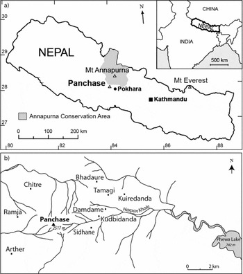
Panchase Mountain, north-west of Pokhara, 83° 45′ to 83° 57′ E and 28° 12′ to 28° 18′ N, in the Middle Hills of Central Nepal (Fig. 1 a) ranges from 855 m altitude on the Harpan River to 2517 m altitude at the peak of Panchase (Fig. 1 b), and the forests range from 1450 m altitude to the peak. The forests cover c. 10–12 km2 and do not border or connect to any legally protected areas. Panchase Mountain is the origin of many rivers and tributaries supplying water to villages, agricultural lands and many local wetlands, including Phewa Lake (DoF/MFSC 2011). Throughout the Middle Hills the bedrock is dominated by competent phyllites and metamorphosed schist, with interbedding of quartzite; loams and sandy loams are the most common soil types (Carson Reference Carson1992). Climate is subtropical at lower altitudes and moist temperate above 2100 m. Temperature and rainfall data for Panchase are not available; however, data from Lumle Agricultural station (1620 m, c. 8 km to the north) were used to extrapolate mean summer and winter temperatures of 12.3°C and 6.8°C, respectively (Appendix 1, Table S1, see supplementary material at Journals.cambridge.org/ENC). Annual precipitation of 5454 mm at Lumle is the highest recorded in Nepal (Shakya Reference Shakya and Majupuria TC1985).
(a) Location of Panchase Mountain in the Middle Hills of the Western Development Region of Nepal and (b) Panchase Mountain with associated villages and rivers draining into Phewa Lake by Pokhara City.

The forests of Panchase are classified as ‘low to mid-montane hemi-sclerophyllous broadleaf forest with concentrated summer leaf drop’ (Singh & Singh Reference Singh and Singh1992), in which Himalayan oaks dominate and play an important role in maintaining ecosystem integrity. These forests harbour rare and endemic plant species, including three endemic and three threatened species of orchids (Subedi et al. Reference Subedi, Subedi and Chaudhary2007, Reference Subedi, Chaudhary, Vermeulen and Gravendeel2011) and are home to a number of important wildlife species, including the Himalayan black bear (Ursus thibetanus), the common leopard (Panthera pardus), the jackal (Canis aerus) and eight species of bats (Koirala Reference Koirala1998; Aryal & Dhungel Reference Aryal and Dhungel2009).
The forests of Panchase are spread over the districts of Kaski, Parbat and Syangja, and are subject to the Village Development Committees (VDCs) of Arthar, Badhaure/Tamagi, Chapakot, Chitre, Dhikurpokhari, Kaskikot and Salyan. The villages occur between 1400 and 2000 m altitude, most of them bordering forested areas. The ethnic composition is the indigenous Gurung and Magar, together with Brahmin, Chhetri, Bishwokarma, Nepali, Pariyar and Thakali (DoF/MFSC 2011). Approximately 40 000 people live in the three districts and depend upon the forests for fuelwood, timber, fodder collection, litter collection, livestock grazing, medicinal and aromatic plant collection, and illegal hunting to sustain their livelihoods. Additional regulating ecosystem services are water quality and flow regulation. Both Hindus and Buddhists consider the Panchase mountain peak as a sacred religious site and each year a festival draws pilgrims from a large area. The name of the mountain (Panchase), is derived from its extraordinary location and means ‘five seats of the divine mother’.
There were two management regimes in the studied forests; (1) CFs, where the National Forest has been handed over to local FUGs, and is now managed by the local communities, and (2) GMFs, managed by the government in theory, but functioning as an open access resource for all in practice. The borders between the two management regimes were, however, contested in several areas. Community FUGs (CFUGs) constituted 80% of the households in the Panchase area in 2006, and the CFUGs were generally positive to the conservation of the Panchase forest ecosystem (MDO [Macchhapuchhre Development Organization] 2006). The practices of jhadi katne and godmel, namely thinning/pruning and weeding, were carried out inside several of the CFs in winter (January) for approximately 15 days, in order to promote the growth of useful species and to eliminate unwanted species, viewed as weeds. Fuelwood acquired through this activity was distributed equally amongst participants, and typically one person was sent from each household to partake. A tourism master plan with facilitation for CF handover (12 CFs covering 867 ha), demarcation of the Panchase forest, plantation and nursery management, promotion of non-timber forest products (NTFPs), installation of improved cooking stoves (ICS) and solar home systems, trail improvements, initiation of off-seasonal vegetable farming, beekeeping and the plantation of coffee was developed by Nepal Tourism Board and the Global Environmental Facility (GEF) Small Grants Programme (UNDP [United Nations Development Programme] Nepal 2008).
Sampling design
Forest analyses and social surveys were conducted in the pre-monsoon season from February to June 2010. We sampled natural forests and avoided plantations, in both the CFs and in the GMFs, using stratified random sampling where plots were laid out along the hillsides of the three main aspects (east, north and south) of the mountain. Both forest management types were situated on the same mountain, and equal numbers of plots were sampled in each; results from pH and loss on ignition (LOI) analyses indicate only small differences in soil conditions. Tree species richness for the Nepalese Himalayas between 2000 and 2500 m altitude shows a plateau (Bhattarai & Vetaas Reference Bhattarai and Vetaas2006). Consequently, we assume the biophysical conditions of the two sampled management types to be similar and hence comparable. The 10 × 10 m2 plots (0.01 ha) were spaced randomly along the slope by drawing random metres (20–90) of separation. In total, we analysed 90 plots (45 in CFs and 45 in GMFs). We excluded plots where they: (1) had a steeper than 45° slope, and were thus inaccessible; (2) lacked woody vegetation; (3) contained special habitat types, such as grass-dominated stone outcrops; (4) consisted of >50% rock or exposed soil; or (5) contained an established trail. The principal measure of woody species diversity was woody species richness, defined as the number of woody species present within the 0.01 ha plots (see for example Grime Reference Grime1973; Bhattarai & Vetaas Reference Bhattarai and Vetaas2003). We included trees, woody bushes (woody plant with several stems, none dominant, and usually <3 m tall) and woody climbers in this measure. Trees were defined as having a diameter breast height (DBH) >5 cm measured at 1.37 m height, and seedlings and saplings of tree species were counted in each plot. Seedlings were defined as individuals <1.37 m in height with no DBH, while saplings had DBH ≤5 cm at 1.37 m. Species were identified on site (Stainton Reference Stainton1972, Reference Stainton1988; Polunin & Stainton Reference Polunin and Stainton1984). Uncertain and unidentified plants were collected and later identified at the National Herbarium and Plant Laboratory (KATH) at Godawari, Lalitpur and Tribhuvan University Central Herbarium (TUCH), Kirtipur. Ocular cover estimates of crown, bushes, herbs/ferns, graminoids, mosses, exposed soil and rock were made from the centre of the plot. Estimates of lopping, cutting and droppings were recorded on a scale from 0 to 3, where 0 indicates no visible signs and 3 indicates very obvious signs throughout the plot. We recorded the approximate walking time from plots to the nearest village. We sampled soil at a depth of 0–0.3 m (four samples from each plot were pooled, sieved and mixed) and analysed for pH in water:suspension (1:2), determining organic content by LOI combustion in an oven at 550 °C for 6 hours (Black Reference Black1965).
Using a household questionnaire (Appendix 2, see supplementary material at Journals.cambridge.org/ENC), we conducted 30 surveys with farmers in the villages surrounding Panchase Mountain (Fig. 1 b) in order to record species used, estimate biomass outtake (Appendix 1, Fig. S1, see supplementary material at Journals.cambridge.org/ENC) and identify perceived forest ecosystem services. Important crops and livestock types were recorded, along with crop- and livestock-damaging species. The questionnaire also contained questions about the present state of the forest compared to the period 10 years previously, and major disturbance events, if any. We strived to achieve gender, age and ethnic equality by actively choosing to interview young and old, as well as male and female respondents, however, many of the villages were predominantly composed of one or two ethnic groups: the people interviewed ranged in age from 18 to 73 years, with a median age of 40 years, and with a 50/50 gender distribution. Village size ranged from 34 to 193 households, with three to seven people per household.
Data analyses
Both univariate and multivariate statistical methods were used to explore relationships between species richness, species composition and environmental variables in CFs and GMFs. To portray gradients and overall successional trends, we analysed the vegetation data using multivariate ordination techniques. A detrended correspondence analysis (DCA; Hill & Gauch Reference Hill and Gauch1980) with downscaling of rare species found the length of gradient for the first ordination axis to be 1.66 SD, hence linear-based ordination methods were used. A multivariate redundancy analysis (RDA; ter Braak Reference ter Braak, Jongman, ter Braak and Tongeren1987) was used to quantify and visualise effects of environmental factors based on measured factors related to disturbance, namely walking distance, canopy cover, lopping and cutting. Ordination analyses and ordination diagrams used the software package VEGAN in R 2.12.2. (R 4 Development Core Team 2010). We used the generalized linear model (GLM) approach to test effects of the different environmental and human disturbance factors on species richness, and seedling and sapling numbers in the GMF and CF, performing all analyses in R 2.12.2. (R 4 Development Core Team 2010).
RESULTS
Woody species richness, composition and forest structure
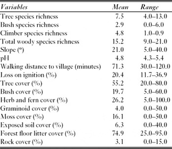
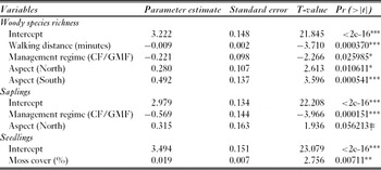
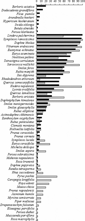
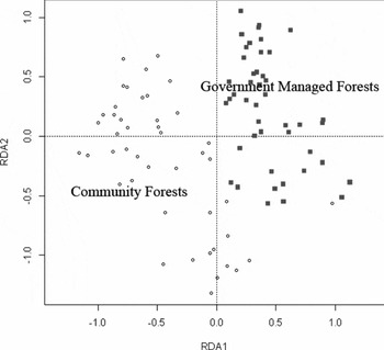
We recorded a total of 60 woody species from the forests of the Panchase Mountain, constituting 28 species of trees, 17 species of woody bushes and 15 species of woody climbers (Fig. 2) with an average of 15.2 species per plot (Table 1). The five most commonly occurring species in order of occurrence were Symplocos ramosissima, Daphne bholua, Viburnum erubescens, Euonymus echinatus and Lindera pulcherrima, showing a mix of trees, woody bushes and climbers. The much used tree species Neolitsea pallens, Lyonia ovalifolia, Ilex dipyrena, Quercus semecarpifolia, Rhododendron arboreum and Quercus lamellosa occurred in 30% or more of all sampled plots. Altogether, we found 52 species in the CFs and 47 species in the GMFs. Species richness ranged from 9 to 21 in the GMFs and from 12 to 20 in the CFs, and was significantly higher in the CF plots in comparison to in the GMF plots (F1,78.811 = 3.2084, p < 0.001, n = 90). Walking time to the nearest village, as well as aspect, were also significant variables (Table 2); species richness decreased as the walking distance from the nearest village increased, and there were more species occurring at the southern aspect. Canopy cover varied between 20% and 80% in both forest types, however the GMF plots had significantly higher canopy cover (p < 0.05, n = 90) with a mean of 60 ± 18% compared to the CF plots with a mean of 50 ± 13%. The RDA ordination showed a clear separation of the sampled plots into two clusters based on the human disturbance factors (Fig. 3, Appendix 1, Fig. S2, see supplementary material at Journals.cambridge.org/ENC). Eigenvalues for the first four axes were 0.6145, 0.2972, 0.1759 and 0.1368, respectively, and the proportions explained were 0.4598, 0.2224, 0.1316 and 0.1023.
Mean and range of species richness and measured environmental variables in the sampled plots in government managed forest and the community forest at Panchase Mountain, Nepal (n = 90).

Results of generalized linear models (GLMs) exploring factors in the effects of the measured environmental and human disturbance factors on woody species richness, and seedling and sapling numbers, in forests under different management regimes at Panchase, Central Nepal. We used forward selection and only significant variables are included, n = 90. CF = community forest, GMF = government managed forest. Significance: ***p = 0, **p = 0.001, *p = 0.01, ǂ p = 0.05.

Occurrence of woody species (per cent presence in the 45 × 2 sampled plots) in government managed forest (■), intermixed in both government managed forest and community forest (■/□), and only in community forest (□) in broadleaf forests of Panchase, Central Nepal.

Multivariate redundancy analysis (RDA) ordination of sampled plots in the government managed forest (filled squares) and the community forest (open circles) in relation to anthropogenic disturbance measures at the Panchase Mountain in Central Nepal.

On average, the GMFs contained 2108 tree saplings ha−1, which was almost twice as many saplings as the CFs, which averaged 1193 saplings ha−1 (p < 0.001, n = 90); management regime and aspect were significant variables (Table 2). Tree seedling density was roughly similar; the GMFs contained 4447 seedlings ha−1 and CFs 4644 seedlings ha−1 (p = 0.8028, n = 90), and moss cover (a human disturbance variable as it reflects the intensity of trampling and browsing) was the only significant variable (Table 2). Species with high seedling and sapling numbers were Symplocos ramosissima, Eurya acuminata, Lindera pulcherrima and Lyonia ovalifolia, reflecting the composition of the mature forest. Quercus lamellosa and Q. semecarpifolia had very few saplings and seedlings in either forest, even though these oak species constituted the trees with the largest DBH in both cases. In contrast, Rhododendron arboreum had high seedling and sapling density in GMFs, but not in the CFs, while Daphniphyllum himalense had almost no seedlings or saplings in the GMFs, but was present in high densities of both in the CFs.
Forest ecosystem services and the farming system
Rainfed cultivation was the most common practice, and average size of farms was 0.75 ha per household. Commonly grown crops were maize, wheat, millet, potato and paddy. Additionally, farmers grew smaller crops of soybean, oats, mustard, radish, cabbage, carrots and garlic. Livestock rearing was an integral part of the rural livelihood and common livestock were chickens, buffaloes, goats, sheep, cows, oxen and pigs.
Farmers used the forest substantially with regard to provisioning ecosystem services, mainly related to biomass outtake. The respondents’ perception of the overall condition of the forest were increasing (76%), stable (17%) or decreasing (7%). When asked about important ecosystem services provided by the forest ecosystem, all the respondents claimed that fuelwood, fodder and medicinal and edible plants were important resources they obtained from the forest. Additionally, 86% stated that timber and 21% that litter for bedding and compost were important. The harvesting time of forest products differed between CFs. Generally, a 15-day period was assigned for harvesting fuelwood during winter, after the rice harvesting. In the CFs closest to farm households, harvesting of woody resources was prohibited for most of the year and only permitted according to availability of resources and free time after harvesting crops. Availability of resources was determined by visual observation and long local experience of forest management; communities felt more ownership of forests located close to their villages/households. In CFs located further away, more time was required to harvest forest resources and one month was allotted for collection. Harvesting outside the allotted time frame incurred fines. The GMF had open access for all, all year. Within the GMFs around the peak of Panchase, hundreds of non-milk-yielding buffaloes were grazing year round, together with a larger number of animals during the monsoon. Stall feeding was generally practised for milk-yielding animals. Although the GMFs were managed by the government, the presence of government authority was very rare and the forest range office is located a day's travel from Panchase Mountain. Some of the wild animals were depriving the local farmers of their crops. The three most crop-damaging animals were considered to be monkey, porcupine and hare, damaging crops often (63%), sometimes (7%) or rarely (30%). Only two wildlife species were described as damaging livestock, namely, leopard and jackal, sometimes (73%) or rarely (27%). When asked about major disturbance events of the past, nearly all the 30 respondents replied ‘occasional fire’ and ‘heavy snowfall which led to tree uprooting’. Fibre yielding, edible or medicinal plant species were being collected in the forests for traditional use and/or for commercial trade. The most commonly used non-timber plants were Swertia spp., Paris polyphylla, Girardinia diversifolia and Centella spp. in descending order of importance. Important edible plants included Berberis spp., Rubus spp., Asparagus racemosus, Myrica esculenta, Viburnum mullaha, Dioscorea spp., Smilax spp., mushrooms, fern shoots, bamboo shoots, and seeds of Castanopsis indica. The endangered tree fern Cyathea spinulosa was observed along streams, and its young shoots and seedlings used for human consumption. Two commonly used fibre plants found above 2000 m altitude were the woody bush Daphne bholua (named chet barua locally), where the bark is used for paper production, and Girardinia diversifolia (named allo locally), a tall perennial herb producing a fine silky fibre for the production of coarse clothing, for example the Gurung's traditional cloths, and ropes. On-farm trees, a form of agro-forestry, were common in the north-east, but not in the south-west. Mitigating fodder scarcity, time saving, yielding fuelwood and/or easily available seedlings were reasons for planting on-farm fodder trees.
DISCUSSION
Biodiversity and governance of forest resources
We found higher woody species richness in the CFs than in the GMFs, supporting findings of other studies from the Himalayas (see Gautam et al. Reference Gautam, Webb, Shivakoti and Zoebisch2003 and references therein). Maintaining a high diversity of woody species is important; it provides a broad resource base for fodder collection throughout the year, as hill farmers have a sophisticated set of criteria for assessing fodder quality in relation to season, livestock type and qualitative properties (Thapa et al. Reference Thapa, Walker and Sinclair1997; Aase & Vetaas Reference Aase and Vetaas2007). Due to free access, the GMFs suffered degradation, and many patches within the forests were converted to treeless openings, dominated by grasses and bushes (Berberis spp.). High sapling density in the GMFs indicates a young forest structure where large trees have been felled for timber and smaller trees for fuelwood. This study thus supports the argument that generally, the community-managed forests are less degraded and more species rich than open access forests (Ostrom Reference Ostrom1990). Across the Middle Hills, there are reports of a marked reversal in the deforestation trend seen in the 1970s as a result of forestation programmes and local people's involvement in forest management (Gautam et al. Reference Gautam, Webb, Shivakoti and Zoebisch2003), giving support to community-based forest governance. However, although the CF approach in Nepal has demonstrated notable successes, it still has several shortcomings. The practice of using a few selected species for fuelwood and fodder may have consequences for plant diversity, community structure and regeneration. Particularly, species diversity may drop due to a management system that focuses solely on forest products and the removal of unwanted species (Gautam & Watanabe Reference Gautam and Watanabe2005). Such silvicultural practices, where CFUGs tend to conserve only ‘useful’ species, may have negative effects on overall biodiversity in the long term (Baral & Katzensteiner Reference Baral and Katzensteiner2009). We analysed woody species diversity and further studies are needed to confirm whether this is also true for Panchase Mountain. Loss of overall biodiversity is, however, documented from similar regions in the Himalayas (Chaudhary Reference Chaudhary2000). Additionally, CF does not include management strategies that promote natural regeneration of the important oak species in this system (Måren & Vetaas Reference Måren and Vetaas2007).
The survey respondents revealed a genuine sense of responsibility and awareness for the forest and its ability to provide them with provisioning, regulating, supporting and cultural ecosystem services. They highlighted the positive effects of CF, regulating biomass outtake and preventing overexploitation as seen in the open access GMFs. Community participation was mentioned specifically as a success factor, as well as mass out-migration of residents from the area and increasing environmental awareness. The people of Panchase's general notion was that the deforestation and forest degradation trend of the past has slowed down or reversed, consequently benefiting forest conservation and reducing landslides, as deforestation in steep terrain with high precipitation is known to increase landslide risks (Salyan VDC recently suffered a large landslide in an area of sparse forest cover).
Panchase Mountain also provides a multitude of cultural services. Both Hindus and Buddhists consider Panchase Mountain a sacred religious site. The Bala Chaturdasi festival attracts pilgrims from a large area. This notion of Panchase as sacred may contribute to the conservation of its forests, as documented from other areas on the sub-Indian continent (Bhagwat et al. Reference Bhagwat, Kushalappa, Williams and Brown2005; Ormsby & Bhagwat Reference Ormsby and Bhagwhat2010). This form of informal protection in the landscape matrix surrounding protected areas and cropped lands should be recognized as a potentially important component for successful biodiversity conservation. The importance of conservation outside formally protected areas has in recent years gained increased attention internationally (Bhagwat et al. Reference Bhagwat, Willis, Birks and Whittaker2008; Willis & Bhagwat Reference Willis and Bhagwat2009), and our study demonstrates that research outside legally protected areas is needed to enable a fuller understanding and provide a sound basis for environmental conservation of the biodiverse forests of the Himalayas.
Farmers and forest ecosystem services
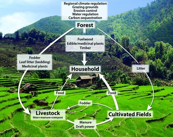
The forests of Panchase are integral parts of the subsistence agro-economy of the region, as they are the sources of fuelwood, fodder, timber, nutrients, and edible, aromatic and medicinal plants (Fig. 4). Crop and livestock productivity was maintained by inputs of biomass and nutrients derived from the forest. There were three important biomass based ecosystem services.
Traditionally, in the Middle Hills farming system of Nepal, crop production, livestock husbandry and forestry are closely related, as illustrated. Line thickness indicates the importance of each element's contribution to the household. Biomass and nutrients flow from forest to farm household through the traditional system of leaf fodder collection by lopping trees to feed stall fed livestock, and by forest leaf litter collection. Leaf litter and fodder residue are mixed with livestock manure to form a natural fertilizer for enhancing soil quality and crop production. Important regulating and provisioning services benefiting the household are listed at the top.

-
(1) Fuelwood. In the absence of alternatives, fuelwood remains the only source for cooking and heating for the vast majority of the population in the area and, in spite of the various degrees of forest product dependency amongst the respondent households, all of them relied on fuelwood for their daily livelihood. Preferred fuelwood species were Daphniphyllum himalense, Schima wallichii, C. stanopsis indica, C. tribuloides, Mallotus nepalensis and Rhododendron arboreum, some found in the plots while others occurred at lower altitudes, close to the settlements.
-
(2) Fodder. As livestock comprises a major part of the Himalayan agro-ecological system, fodder collection is the second most important biomass outtake, especially in dry periods when on-farm fodder is particularly sparse, and preferred species were Schima wallichii, C. stanopsis indica, C. tribuloides, Eurya acuminata, Prunus species, Quercus lamellosa and Q. semecarpifolia.
-
(3) Leaf litter.The forests of Panchase are vital to most of the local farmers who cannot afford to buy chemical fertilizers. To sustain 1 ha of terraced farmland under the traditional system in the Middle Hills, 1–4 ha of forest is needed (Ives & Messerli Reference Ives and Messerli1989). People collected leaf litter frequently to prepare compost manure, as the traditional faming practice is based on the input of organic manure to fertilize the cropped fields and enhance soil quality. Leaf litter of Schima wallichii was most preferred, but Quercus semecarpifolia, Daphniphyllum himalense, C. stanopsis indica, C. tribuloides, Lyonia ovalifolia and Alnus nepalensis were also used.
Some of the recorded woody species were providing multiple services and may consequently be under higher anthropogenic pressure, such as the oak species. The natural mixed Quercus and Rhododendron forests (Stainton Reference Stainton1972) appear to be replaced towards the settlements at lower altitudes by a mixed Rhododendron and Daphniphyllum forest. Daphniphyllum himalense, an early successional species (Stainton Reference Stainton1972), tends to colonize fallow lands close to settlements and in forest openings. It cannot be used as fodder and thus gains a regeneration advantage in comparison to the much sought after and palatable Quercus species. The occurrence of few Daphniphyllum saplings in the CFs as compared to the GMFs is explained by the practice of weeding and pruning inside these CFs.
The farmers of Panchase raised concerns over three limiting factors to agricultural production, namely labour, water and fertilizer. In a study conducted just north of the Panchase Mountain (Thapa Reference Thapa1996), all 298 households applied compost/manure to their fields and the majority of them reported inadequate amounts of compost. The use of tree fodder and forest forage combined with grasses from terrace risers ensures a net movement of nitrogen from the forest land to the agricultural land in the traditional hill farming system (Fig. 4), although the exact magnitude of this movement is not known (Pilbeam et al. Reference Pilbeam, Tripathi, Sherchan, Gregory and Gaunt2000). Traditionally, children have played a significant role in supporting women in the collection of livestock fodder and forest leaf litter, and in carrying compost and manure to the infields (Pilbeam et al. Reference Pilbeam, Tripathi, Sherchan, Gregory and Gaunt2000). As income has increased for families with migrant workers (in Pokhara, Kathmandu or abroad) in the Panchase area, the number of children that attend school has increased. This, in turn, has increased the workload for the local women, because less labour is available for the collection of forage, bedding and leaf litter for compost. The outcome may be twofold; fields are laid fallow due to out-migration and lack of labour, or yields from active fields decrease as a result of reduced nutrient and biomass input. The former was observed around villages on the north-eastern slopes of Panchase.
Implications for biodiversity conservation and forest management
The Panchase Mountain constitutes a crucial link between the protected areas in Chitwan National Park to the south and Annapurna Conservation Area to the north, because Panchase still constitutes relatively species rich temperate broadleaved forests. Very few protected areas in the Himalayas have lowland, mid-elevation and highland represented, capturing the full scale of the Himalayan diversity (Shrestha et al. Reference Shrestha, Shrestha, Chaudhary and Chaudhary2010). An initiative to conserve Panchase as the very first protected forest in Nepal is now being undertaken by the Department of Forest (Ministry of Forests and Soil Conservation), Government of Nepal and other stakeholders. This will be unlike all other national protected areas (national parks, wildlife reserves, hunting reserves and conservation areas), which are managed by the Department of National Parks and Wildlife Conservation. Nevertheless, conservation measures cannot be successful without the cooperation of the local population. We have documented a large and extensive biological knowledge base among the local inhabitants and this can be of great potential in future management of forest biodiversity and condition, as also advocated by Nagendra and Ostrom (Reference Nagendra and Ostrom2011). To further reduce pressure on the forest, the benefits of the community participation should be employed to focus on key challenges and move forward with the facilitation of alternative energy sources such as installation of biogas, establishment of small-scale hydropower, adoption of improved cooking stoves, socioeconomic enhancement and education, as also recommended in the Panchase Protected Forest Management Plan (DoF/MFSC 2011). For further protection and development of Panchase forests, over 50% of the respondents suggested (1) promoting conservation through regulating the free access to the GMFs, (2) increasing awareness of sustainable development, and (3) economic strengthening of the local communities. The concept of sustainability combines balanced resource use with economic viability, integrating biological, social and economic aspects at the farm household level (Perrings et al. Reference Perrings, Duraiappah, Larigauderie and Mooney2011). In sum, biodiversity conservation needs to be seen in a broader sense in areas dominated by poverty and social inequity (Agrawal & Redford Reference Agrawal and Redford2006).
CONCLUSION
We found that, in the forests of Panchase, CFs contained a higher woody species richness and were better managed than GMFs. Local people were knowledgeable about good forest management practice, and suggested potential improvements for GMF areas, such as regulating free access, increasing awareness of sustainable development, and economic strengthening of local communities. The proposed Panchase protected forest will benefit from the existing knowledge pool and CF management system, but, first and foremost, from the genuine sense of community responsibility and awareness for the forest and its ability to provide local people with provisioning, regulating, supporting and cultural ecosystem services. Given the rich biodiversity of the Panchase area, its designation to this new conservation category, ‘protected forest’, will hopefully contribute to the sustainable environmental conservation of Panchase Mountain for the future.
ACKNOWLEDGEMENTS
Thanks to B. Chapagain, A. Chaudhary, K. Bhatta, R. Gurung and K. McInturff for field assistance, and to all the villagers around Panchase who participated in the project. B. Gurung and Macchhapuchhre Development Organization (MDO) contributed valuable information. This was funded by the Norwegian Research Council (190153/V10) and Grolle Olsens Legat.