Spatial reference systems such as maps and geographic information systems are fundamental tools underpinning ecological and environmental studies, particularly when studies cover broad spatial domains. In Antarctica, spatial reference systems include the pan-Antarctic SCAR (Scientific Committee on Antarctic Research) Antarctic Digital Database (www.add.scar.org) and SCAR Composite Gazetteer (https://data.aad.gov.au/aadc/gaz/scar), as well as numerous broad-scale geographic information systems and maps produced by various nations covering their regions of operation and active research. The importance and utility of these existing systems and maps to operations and research is immense and unquestionable. However, generally only a few of the geographic features in these existing maps and systems have a unique identifier such as a name associated with them. This limits the ability to easily, accurately and consistently record and communicate spatial information at fine spatial scales. Here, we briefly describe a spatial reference and identification system for coastal ice-free land across 4500 km of the East Antarctic coastline. Although ice-free land covers <1% of the Antarctic continent, it is a critical habitat for almost all Antarctic terrestrial biodiversity (Lee et al., Reference Lee, Raymond, Bracegirdle, Chadés, Fuller, Shaw and Terauds2017), is important for land-breeding marine species such as seabirds and marine mammals (Croxall & Prince, Reference Croxall and Prince2009) and is a window for understanding the geological processes that have shaped Antarctica (Campbell & Claridge, Reference Campbell and Claridge1987).
The spatial reference system comprises a series of maps in PDF format and a related database and was specifically designed for practical use in field-based ecological and environmental studies.
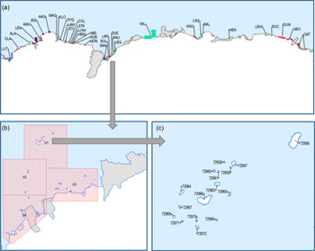
The maps were produced in a geographic information system using physical data sourced from the Australian Antarctic Territory Coastline 2003 data set produced by Geoscience Australia and the Australian Antarctic Division, and from the Antarctic Digital Database version 4.0 produced for the Scientific Committee on Antarctic Research. The maps show ice-free land between longitudes 37°E and 160°E and include islands within 100 km north from the Antarctic coastline and outcrops of continental rock within 1 km south from the coastline. Each of these islands and rock outcrops is referred to here as a “geographic site”. There are 252 individual maps arranged in a spatial hierarchy of sub-groups (n = 216) and groups (n = 35) (Fig. 1(a) and (b)). The partitioning of space into sub-groups and groups was done heuristically to attain scales that are practical to use and ensure that geographic sites are visually recognisable in the field, to limit the number of features in each map and ensure readability, and to locate boundaries between sub-groups and groups within natural gaps in the distribution of ice-free land. The 35 group maps are each named according to a prominent feature contained within them and summarised by a three-letter code (Fig. 1(a)). For example, the Svenner Islands group in Figure 1(b) contains, but is not restricted to, a group of islands collectively called the Svenner Islands and is coded “SVE”. The sub-group maps within a group are each identified by the three-letter code of the group, the two letter code “SG” indicating sub-group, and a numeric suffix (e.g. the four sub-group maps within the Svenner Group are named SVE_SG_01, SVE_SG_02, SVE_SG_03 and SVE_SG_04). The sub-group maps also include an automatically generated Unique Feature Identifier (UFI) for each geographic site (Fig. 1(c)) which allows sites to be uniquely, accurately and unambiguously identified and communicated. The UFIs for island geographic sites in the maps comprise a numeric code of up to five digits (Fig. 1(c)), while the UFIs for continental rock sites comprise a numeric code of up to five digits prefaced by “R”.
Example of the spatial hierarchy of maps and geographic site identification, focusing on the northern islands of the Svenner Islands group in Prydz Bay, East Antarctica. (a) Map of all 35 spatial groups across East Antarctica; (b) map of the Svenner Islands spatial group and four sub-groups; (c) map of islands in the Svenner Islands sub-group 1, showing Unique Feature Identifiers for each island. The maps shown here are subsets of the full maps to illustrate important features described in the text. The full maps also include a map title, a legend, a scale, and latitudes and longitudes. The maps are freely available at doi: 10.26179/53yk-8z83.

The database has a record for each geographic site shown in the maps (n = 4884 total sites, comprising 4490 islands and 394 outcrops of exposed continental rock). Each geographic site record in the database has the same alpha-numeric code of the UFI shown on the maps, except that the numeric-only island UFIs in the maps are prefaced by “IS” in the database (it was not possible to include this preface in the maps because it compromised readability). Other attributes associated with each geographic site include: (a) the sub-group in which it occurs; (b) the latitude and longitude of its centroid; (c) the area of the site; (d) where relevant, the name(s) and place identification from the SCAR Composite Gazetteer and (e) where relevant, qualifying commentary on the geographic site.
The reference system has been an extremely useful tool in our research by underpinning a gap analysis of historical observations of penguin populations (Southwell, Smith & Bender, Reference Southwell, Smith and Bender2009), for designing and conducting new surveys of penguin populations (Southwell et al., Reference Southwell, Emmerson, Takahashi, Barbraud, Delord and Weimerskirch2017a), in correcting erroneous conclusions on penguin colonisation and extinction events that resulted from discrepancies in the names and locations of historical records in the literature (Southwell et al., Reference Southwell, Emmerson, Takahashi, Kato, Barbraud, Delord and Weimerskirch2017b) and for designing new surveys of flying seabird populations (current work). It could also provide a foundation tool for a wide range of other environmental studies in coastal East Antarctica in the future. The maps and underlying database are freely available at doi: 10.26179/53yk-8z83.
Acknowledgements
The work was conducted under AAS projects 2722, 4088 and 4518. We thank Jonathon Kool and Ursula Harris from the Australian Antarctic Data Centre and an anonymous reviewer for helpful comments on the manuscript.
Funding
This research received no specific grant from any funding agency, commercial or not-for-profit sectors.
Conflict of interest
There are no conflicts of interest.