1. Introduction
Very little has yet been published on the Lower–Middle Palaeozoic strata and faunas of the Truong Son Terrane in Laos. Recent studies on the Palaeozoic strata of central Laos in close collaboration with the staff of the Department of Mines and Geology (Vientiane) and of the Sepon Mine Lane Xang Minerals Ltd (LXML), a subsidiary of Minerals and Metals Group (MMG), have revealed Lower Ordovician – Carboniferous faunas in generally well-studied structural, stratigraphic and sedimentological settings that record the rift, drift and collision history of the Truong Song Terrane (Burrett et al. Reference Burrett, Zaw, Meffre, Lai, Khositanont, Chaodumrong, Udchachon, Ekins and Halpin2014; Cannell et al. Reference Cannell, Stewart, Williams, Wallace, Burrett and Davis2015).
Early geological work in Laos during French colonial times was hampered by physical, infrastructure, man-power, political and financial constraints (Stokes, Reference Stokes, Chuwong and Tithimakorn2008). Regional surveys and collection of fossils by Bourret (Reference Bourret1925) and Hoffet (Reference Hoffet1933, Reference Hoffet1937) in the south and Dussault (Reference Dussault1919) in the north of central Laos sketched the broad details of regional geology and provided age contraints for some of the sequences. Devonian limestone was recognized and mapped in the present study area (Hoffet, Reference Hoffet1937). Wars and insurgencies curtailed further studies until the 1990s. In 1990 a joint survey of central Laos was initiated by the geological surveys of Laos and Vietnam through the Hanoi-based INTERGEO organization, which resulted in the publication of seven 1:200,000 scale maps and a three-volume memoir (Tran Van Ban, Reference Tran Van2000; Tran Van Ban et al. Reference Van Ban, Vu, Le, Tran, Ta, Phengthavongsa, Vilayhack, Sayaseng and Thoummarath2000a, b). However, this survey was also hampered by financial problems, malaria and widespread unexploded ordnance. Ordovician–Cretaceous strata were recognized, and formations defined, mapped and correlated to similar units in neighbouring Vietnam. Little attention was paid to structural geology and, as a result, formation thicknesses were greatly exaggerated. The survey did not extend south to the present-day main Sepon Mine Area. In the early 1990s exploration by company geologists (Conzinc Riotinto of Australia or CRA) also resulted in the discovery of significant gold and copper geochemical anomalies. Ultimately, this exploratory work led to the establishment of the economically important Sepon mine – smelter complex. Drilling and fieldwork resulted in the erection of a stratigraphy by Morris (Reference Morris1998) that is little changed today (S. Ekins, unpub. Honours thesis, University of Tasmania, 2005; Smith, Olberg & Manini, Reference Smith, Olberg, Manini, Rhodes, Steininger and Vikre2005; Bouthathep Reference Bouthathep, Senebouttalath and Roibang2013; Cannell et al. Reference Cannell, Stewart, Williams, Wallace, Burrett and Davis2015). Most recently, we have obtained fossils from all of the formations in the Sepon Mine area and, using conodonts, have dated all of the carbonate units. We have described a Frasnian radiolarian and tentaculitid fauna from the Nam Kian Formation of the Sepon Mine area and from cherts 150 km to the NW of the mine (Thassanapak, Udchachon & Burrett, Reference Thassanapak, Udchachon and Burrett2012; Udchachon et al. Reference Udchachon, Thassanapak, Feng and Burrett2017).
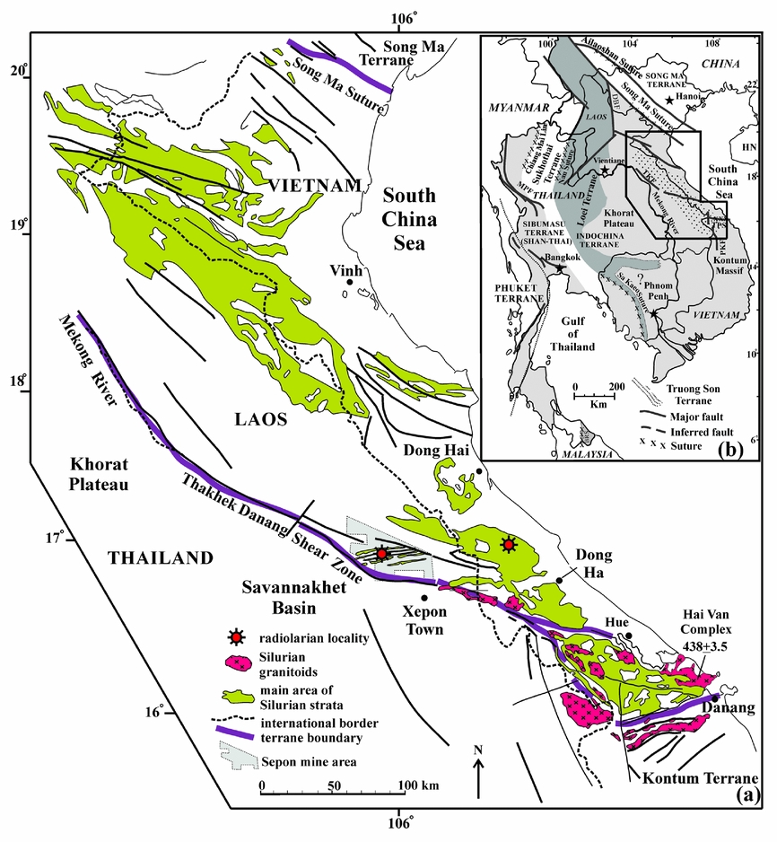
The present study area is in the southern part of the Truong Son Terrane and is bordered to the south by the Thakhek–Danang Shear Zone or Lineament (Mouret, Reference Mouret, Angsuwathana, Wongwanich, Tansathein, Wongsomsak and Tulyatid1994; Lepvrier et al. Reference Lepvrier, Maluski, Van Vu, Thi and Van Vuong2004, Reference Lepvrier, Van Vuong, Maluski, Thi and Van Vu2008; Burrett et al. Reference Burrett, Zaw, Meffre, Lai, Khositanont, Chaodumrong, Udchachon, Ekins and Halpin2014) (Fig. 1). We suggest correlations between the Palaeozoic strata of central Laos and central Vietnam and assess the Silurian palaeogeography and active tectonic margin setting of the southern Truong Son Terrane.
(a) Distribution of Upper Ordovician – Silurian sequences on Truong Son Terrane from Phan Cu Tien (Reference Phan1991). The Truong Son Terrane is bordered in the north by the Song Ma Suture and in the south and west by the Thakhek–Danang Shear Zone. This map includes some older Ordovician and some Early Devonian sequences as being of Silurian age. Intrusive granitoids are mainly of Silurian age but also may include some Late Ordovician and Early Devonian granitoids. Some granitoids along the Thakhek–Danang Shear Zone are orthogneisses. Note the general strike of strata is NW–SE with the restricted area around the Sepon Mine having an anomalous E–W strike and the Silurian strata occurring as thin slices. Radiolarian locality in Vietnam is the Wenlock fauna illustrated by Tran Van Tri & Vu Khuc (Reference Van Tri and Khuc2011). The zircon date for the Hai Van Complex, north of Danang, is from Shi et al. (Reference Shi, Lin, Fan, Deng, Cong, My–Dung, Zhu and Wang2015). (b) Terrane map of part of mainland Southeast Asia.

About 30 Silurian radiolarian faunas have been described worldwide, but few of these are from mainland Asia. Here we document a Ludlow–Pridoli radiolarian fauna in cherts from south-central Laos (Lao PDR) which is the second illustrated Silurian radiolarian fauna from SE Asia (Tran Van Tri & Vu Khuc, Reference Van Tri and Khuc2011). This is the third in a series of papers that document the biostratigraphy and palaeoenvironmental setting of the Laotian Palaeozoic strata (Thassanapak, Udchachon & Burrett, Reference Thassanapak, Udchachon and Burrett2012; Udchachon et al. Reference Udchachon, Thassanapak, Feng and Burrett2017).
2. Geological setting
2.a. Regional geology
Mainland Southeast Asia has long been assumed to consist of two main terranes: the Sibumasu Terrane (Shan–Thai Terrane in part) and the Indochina Terrane (Bunopas & Vella, Reference Bunopas and Vella1978; Bunopas, Reference Bunopas1982; Burrett & Stait, Reference Burrett, Stait and McKenzie1987; Burrett, Long & Stait, Reference Burrett, Long, Stait, McKerrow and Scotese1990; Reference Metcalfe, Hall and BlundellMetcalfe, 1996a, b). The volcanic arc Sukhothai Terrane and the Inthanon Terrane were recognized subsequently (Metcalfe, Reference Metcalfe2013). Recent studies in Laos and Vietnam have substantially increased the number of terranes (Lepvrier et al. Reference Lepvrier, Maluski, Van Vu, Thi and Van Vuong2004, Reference Lepvrier, Van Vuong, Maluski, Thi and Van Vu2008; Burrett et al. Reference Burrett, Zaw, Meffre, Lai, Khositanont, Chaodumrong, Udchachon, Ekins and Halpin2014; Khin Zaw et al. Reference Zaw, Meffre, Lai, Burrett, Santosh, Graham, Manaka, Salam, Kamvong and Cromie2014). Indochina has been subdivided into the Loei Terrane (or Fold Belt or Loei–Petchabun Terrane/Fold Belt), the Song Ma Terrane, the Truong Son Terrane (or Fold Belt), the Khorat Terrane and the Kontum Terrane (or Block or Massif) based on distinctive tectonostratigraphic and magmatic histories (Lepvrier et al. Reference Lepvrier, Maluski, Van Vu, Thi and Van Vuong2004; Burrett et al. Reference Burrett, Zaw, Meffre, Lai, Khositanont, Chaodumrong, Udchachon, Ekins and Halpin2014; Khin Zaw et al. Reference Zaw, Meffre, Lai, Burrett, Santosh, Graham, Manaka, Salam, Kamvong and Cromie2014). The Truong Son Terrane (Fig. 1) is characterized by Ordovician–Silurian strata, Permo-Triassic granitoids and very restricted Devonian magmatism. Ordovician and Silurian marine faunas are widespread in the Truong Son Terrane, but are absent from the adjacent Khorat and Kontum terranes and very rare in the Loei Terrane. Upper Silurian – Lower Devonian red beds (‘Old Red Sandstone’ facies) extend across the northern and central parts of the Truong Son Terrane, are absent from adjacent Indochina terranes and were probably formed by collision of the South China Terrane with the Truong Son Terrane along the Song Ma Suture. Famennian shallow-water platform limestones are widespread on the Truong Son Terrane, but are absent from the Loei, Khorat and Kontum terranes. Permian granite intrusions are widespread and may have been caused by southwards subduction under the Song Ma Suture zone or by northwards subduction along a precursor subduction zone in the approximate position of the Thakhek–Danang Shear Zone (Shi et al. Reference Shi, Lin, Fan, Deng, Cong, My–Dung, Zhu and Wang2015). The Indochina Composite Terrane probably amalgamated in several collisions during Carboniferous and Triassic time (Lepvrier et al. Reference Lepvrier, Maluski, Van Vu, Thi and Van Vuong2004; Burrett et al. Reference Burrett, Zaw, Meffre, Lai, Khositanont, Chaodumrong, Udchachon, Ekins and Halpin2014; Khin Zaw et al. Reference Zaw, Meffre, Lai, Burrett, Santosh, Graham, Manaka, Salam, Kamvong and Cromie2014).
The stratigraphic sequences in central Vietnam and in central Laos are similar and range from Ordovician to Cenozoic strata (Tran Van Tri, Reference Van Tri1977; Tran Van Ban, Reference Tran Van2000; Tran Van Tri & Vu Khuc, Reference Van Tri and Khuc2011; Williams et al. Reference Williams, Komatsu, Tanaka, Nguyen, Zalasiewicz, Vandenbrooke, Wallis and Perrier2016). The Palaeozoic sequences were deformed in several phases of the Triassic Indosinian orogeny. Post-orogenic Triassic siliciclastics were deposited in small basins and unconformably overlain by mainly terrestrial siliciclastics of the Upper Jurassic – Cretaceous Nam Theun Group, equivalent to the widespread Khorat Group in Thailand (Carter et al. Reference Carter, Roques, Bristow and Kinney2001). Triassic Indosinian deformation and later Cenozoic transcurrent fault movements resulted in the regional NW–SE tectonic grain seen in much of the Truong Son Terrane in Laos and Vietnam (Figs 1, 2). Around the Sepon Mine area, faulting was associated with sinistral movement on the Thakhek–Danang Shear Zone and was contemporaneous with the intrusion of small, but economically important, bodies of rhyodacitic porphyry (RDP) during earliest Permian time (Cannell et al. Reference Cannell, Stewart, Williams, Wallace, Burrett and Davis2015). This deformation event led to the formation of relatively small, fault-bound wedges of sedimentary rock striking E–W, in contrast to the more extensive distribution of the stratigraphic units outside of the mine area which have a NW–SE strike (Fig. 1). Movement on the Thakhek–Danang Shear Zone from the Triassic was dextral, and this shearing continued into the Cenozoic along with dextral movement along several NW–SE-trending shear zones in mainland SE Asia caused by the indentation of India into Asia (Lepvrier et al. Reference Lepvrier, Maluski, Vuong, Roques, Axente and Rangin1997, Reference Lepvrier, Maluski, Van Vu, Thi and Van Vuong2004, Reference Lepvrier, Van Vuong, Maluski, Thi and Van Vu2008).
Geological map of central Laos. Adapted from United Nations (1990) 1: 500 000 map of Laos. The Cretaceous sequence consists of the upper part of Nam Theun Group and the Jurassic sequence is the lower part of Nam Theun Group (both consisting of mainly terrestrial siliciclastics). The Triassic sequence is mainly found in geographically restricted basins and consists of terrestrial siliciclastics. The upper Palaeozoic sedimentary succession consists mainly of platform carbonates of the Upper Carboniferous – Permian Khammouan Formation and the Tournaisian–Visean marine and terrestrial siliciclastics of the Boualapha Formation. The middle Palaeozoic consists mainly of platform carbonates and reef limestones of Devonian–Tournaisian age and Lower Devonian shales. The lower Palaeozoic consists mainly of marine siliciclastics with minor limestone of Ordovician age and Silurian shales and cherts. Granitoids range from the Ordovician to Cretaceous in age.

2.b. Sepon Mine stratigraphy
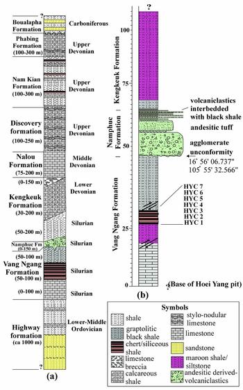
Nine formations are recognized in the Sepon Mine area and range in age from Early Ordovician to Early Carboniferous (Tournaisian) (Fig. 3). The ‘Highway’ and ‘Discovery’ formations were named informally during initial company exploration work and, pending formal description and renaming, are written here within apostrophes. Except for the volcanogenic–conglomeratic Namphuc Formation, all formations are fossiliferous and most contain conodonts. The shallow marine, mainly siliciclastic, ‘Highway’ formation contains a few, thin (1–3 m) limestone beds which exhibit cyanobacterial structures and are probably peritidal. The siliciclastics of the ‘Highway’ formation are unfossiliferous, despite intensive searching, and even trace fossils are absent from outcrops. At least two conodont assemblages are present in rare limestone beds: one of the Pygodus anserinus Zone and another of Floian age (S. Ekins, unpub. Honours thesis, University of Tasmania, 2005).
(a) Stratigraphic column of Sepon Mine area, from Cannell et al. (Reference Cannell, Stewart, Williams, Wallace, Burrett and Davis2015). (b) Faulted stratigraphic column measured in abandoned Hoei Yang pit, showing collection sites for the Hoei Yang section.

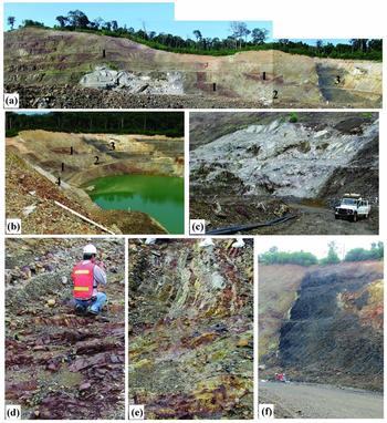
The ‘Highway’ formation is conformably overlain by the 200–300 m thick Vang Ngang Formation. The 0–100 m thick limestone of the lower Vang Ngang Formation contains the conodont Pterospathodus amorphognathoides which indicates a range in age from late Llandovery (or Telychian) to earliest Wenlock (early Sheinwoodian) (S. Ekins, unpub. Honours thesis, University of Tasmania, 2005). A correlate of this limestone is found in the Hoei Yang Pit (Figs 3, 4) but has not yielded conodonts and appears to have a faulted contact with the shales and cherts of the Vang Ngang Formation (Fig. 4c). In the Hoei Yang Pit, the Vang Ngang Formation consists of 20 m of limestone in faulted contact with more than 10 m of maroon siltstone, conformably overlain by 4.5 m of radiolarian chert followed conformably by 24 m of black shale (Figs 3, 4). Although the Vang Ngang Formation limestone in the Hoei Yang Pit appears to be a block or olistolith surrounded by graptolitic shale (Fig. 4c), which may suggest a mélange or olistrostrome, its occurrence in most drill cores through this interval (Cannell et al. Reference Cannell, Stewart, Williams, Wallace, Burrett and Davis2015) over a large area (about 1000 km2) does not support such an origin. Whether this assemblage constitutes a mélange must await detailed study of core from throughout the Sepon Mine Area. The black shale is in faulted contact with the radiolarian chert and contains graptolites that include Normalograptus and Diplograptus, which range in age from Late Ordovician to early Silurian. The graptolitic shales are overlain with slight angular unconformity by the Namphuc Formation (Figs 3–5).
Photographs of the Hoei Yang pit (latitude 16° 56′ 06.737″ N, longitude 105° 55′ 32.566″ E). (a) Study section including 1, maroon shale/siltstone; 2, chert; 3, black shale; and 4, limestone. Sedimentary rocks are separated by irregular intrusions of earliest Permian rhyodacite porphyry (RDP). (b) View of Hoei Yang pit from above. Light-coloured rock between 1 and 1 is RDP. (c) Unfossiliferous limestone correlated to the lower Vang Ngang Formation, which elsewhere in the mine area contains Telychian to Sheinwoodian conodonts. (d) Maroon shale/siltstone. (e) Chert (samples HYC 1–5). (f) Graptolitic black shale (samples HYC 6, 7) containing Normalograptus and Diplograptus. Enclave of black shale within RDP intrusion is seen at right of photograph.

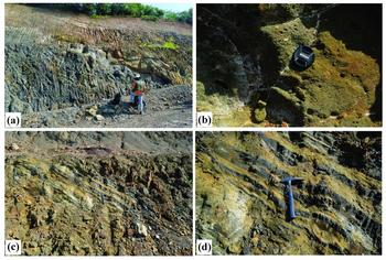
Photographs showing volcaniclastics in the Hoei Yang pit. (a) Contact of graptolitic black shale and volcaniclastics; (b) agglomerate; (c) volcaniclastics interbedded with black shale; and (d) magnification of (c).

The Namphuc Formation is 20 m thick in the Hoei Yang Pit and consists of a volcaniclastic agglomerate with andesitic clasts, with some minor non-volcanic clasts overlain by andesitic tuff (Fig. 5). The basal section of the Namphuc Formation contains clasts of the underlying Vang Ngang Formation (Fig. 5). Generally, the Namphuc Formation ranges over 0–100 m in thickness (Cannell et al. Reference Cannell, Stewart, Williams, Wallace, Burrett and Davis2015), and deposition in a submarine fan palaeoenvironment is likely (Smith, Reference Smith2009). Radiometric ages for andesite, diorite and dacite clasts from the Namphuc Formation of the Sepon Mine area range from 439 +/− 2 Ma to 433 +/− 3.5 Ma and average 436 Ma, equivalent to an Aeronian–Sheinwoodian age (Smith, Reference Smith2009; Melchin, Sadler & Cramer, Reference Melchin, Sadler, Cramer, Gradstein, Ogg, Schmidz and Ogg2012). The Namphuc Formation is overlain gradationally by the 50–200 m thick basal member of the Kengkeuk Formation, which contains retiolitids and monograptids in tuffs at its contact with the Namphuc Formation and grades upwards into red and black non-calcareous pyritic shales containing rare, small proetid trilobites. Elsewhere in the mine area, the Kengkeuk Formation contains a fauna consisting of Aulacopleura (and other proetid trilobites), Monograptus sp. and hyolithids. The conformably overlying Nalou Formation carbonates were deposited in a Givetian–Frasnian platform-margin reef complex, and large blocks of the reef complex are found within the upper part of the Kengkeuk Formation. The Nalou Formation is overlain conformably by the slightly deeper-water calcareous shales of the Discovery Formation and the shales and cherts of the Nam Kian Formation. The Nam Kian Formation contains an upper Frasnian radiolarian and tentaculitid fauna which is identical to that found in cherts 150 km to the NW of the mine (Thassanapak, Udchachon & Burrett, Reference Thassanapak, Udchachon and Burrett2012; Udchachon et al. Reference Udchachon, Thassanapak, Feng and Burrett2017). This fauna indicates relatively deep water, and the chert geochemistry suggests water depth increased towards the south (Udchachon et al. Reference Udchachon, Thassanapak, Feng and Burrett2017). The Nam Kian Formation is succeeded conformably by the mainly shallow-water carbonates of the Phabing Formation which contains Famennian and Tournaisian conodonts. The Phabing Formation also appears to increase in palaeo-water depth towards the south.
3. Radiolarian faunas
3.a. Materials and methods
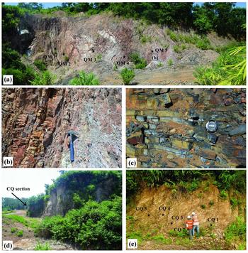
Radiolarians have been extracted from red cherts in the abandoned open-cut Hoei Yang Pit (HYC section) and brown cherts in a small nearby quarry used for road metal (CQ and QM sections). Both quarries show a faulted contact with black graptolitic shales and the radiolarian cherts (Figs 4, 6). Collection sites are shown on Figures 3, 4 and 6. Cherts from the HYC section are folded, with bed thickness averaging about 5 cm with a total thickness of at least 3 m. The cherts from the CQ and QM sections are strongly folded with average bed thickness of 5 cm. Total thickness is difficult to measure but at least 5 m is estimated.
Photographs of the CQ and QM sections in a small abandoned road metal quarry (at latitude 16° 56′ 09.538″ N, longitude 105° 56′ 10.331″ E). (a) Overview of the QM section and sampling points. (b) Chert beds in the QM section magnified from box in (a). (c) Graptolitic black shale. (d) CQ section at entrance to small road metal quarry (view from QM section). (e) CQ section and sampling points.

Chert rock samples from three sections were dissolved in dilute 5–10 % HF solution for 24 hours (method adapted from Pessagno & Newport, Reference Pessagno and Newport1972), and 18 radiolarian species were recovered. The following radiolarian species are identified.
3.b. Systematic palaeontology (H.Thassanapak)
Infrakingdom Rhizaria Cavalier–Smith, Reference Cavalier–Smith2002, emend
Cavalier–Smith, Reference Cavalier–Smith2003
Phylum Retaria Cavalier–Smith, Reference Cavalier–Smith1999
Class Polycystina Ehrenberg, Reference Ehrenberg1839
Order Spumellaria Ehrenberg, Reference Ehrenberg1876
Family Inaniguttidae Nazarov & Ormiston, Reference Nazarov, Ormiston, Petrushevska and Stepanjants1984, sensu Noble, Reference Noble1994
Genus Futobari Furutani, Reference Furutani1990
Type species: Futobari solidus Furutani, Reference Furutani1990
Futobari morishitai Furutani, Reference Furutani1990
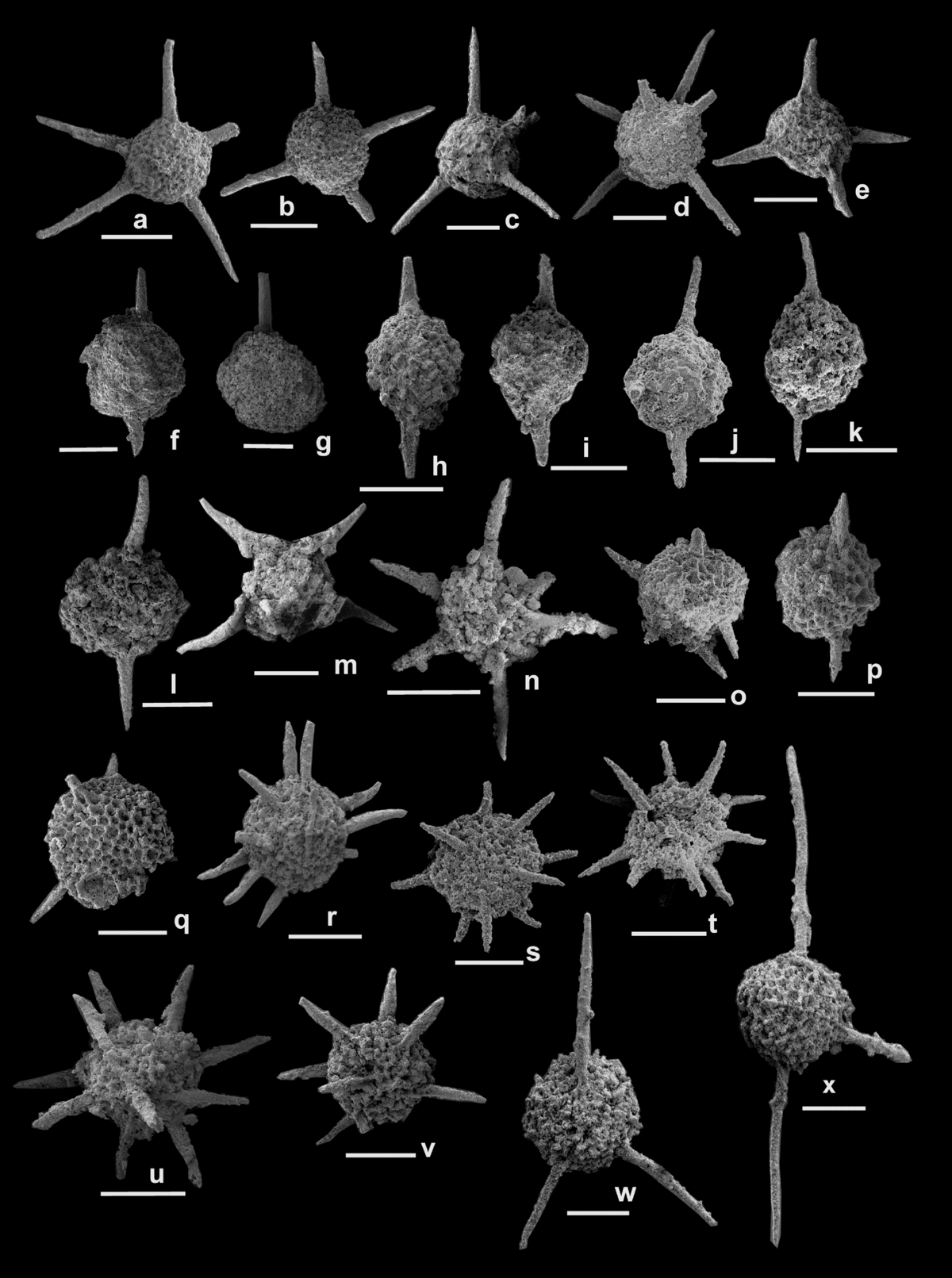
Figures 7a–d, 8a–d, 9a–e
1990 Futobari morishitai Furutani, p. 35, pl. 1, fig. 5, pl. 2, figs 1–3.
1996 Futobari sp. cf. F. morishitai Aitchison, Hada, Ireland & Yoshikura, p. 65, pl. 1, fig. 18; pl. 2, fig. 13; pl. 3, fig. 11.
1997 Futobari morishitai Umeda, pp. 421–422, pl. 2, fig. 16; pl. 4, fig. 13.
1998a Futobari morishitai Umeda, fig. 9.6.
2000 Futobari morishitai Kurihara & Sashida, p. 58, pl. 1, fig. 7.
2004 Futobari morishitai Kurihara, pl. 2, figs 18.
2007 Futobari morishitai Kurihara, p. 231, pl. 2, figs 22, 23.
2013 Futobari morishitai Nuramkhaan, Horie & Tsukada, p. 238, fig. 11L, M; fig. 13O, P.
2015 Futobari morishitai Tetard, Noble, Danelian, Monnet & Lenz, p. 872, fig. 5j.
Scanning electron micrographs of radiolarians from CQ section, Sepon district, Savannakhet province, central Laos. All scale bars: 100 µm (CQ320: SEM number and PRC numbers are specimen numbers in the Palaeontological Research Centre of Mahasarakham University). (a–d) Futobari morishitai: (a) CQ320PRC1; (b) CQ308PRC2; (c) CQ324PRC3; and (d) CQ329PRC4. (e) Futobari solidus (CQ325PRC5). (f) Praespongocoelia parva (CQ304PRC6). (g) Praespongocoelia sp. (CQ14PRC7). (h, i) Pseudospongoprunum sagittatum: (h) CQ347PRC8; and (i) CQ320PRC9. (j, l) Pseudospongoprunum tazukawaensis: (j) CQ320PRC10; and (l) CQ307PRC62. (k) Pseudospongoprunum sp. (CQ327PRC61). (m) Rotasphaera sp. cf. R. quadrata (CQ314PRC63). (n) Secuicollacta sp. cf. S. cassa (CQ310PRC64). (o–q) Zadrappolus yoshikiensis: (o) CQ321PRC65; (p) CQ325PRC66; (q) CQ345PRC67. (r–v) Zadrappolus tenuis: (r) CQ38PRC68; (s) CQ316PRC69; (t) CQ333PRC70; (u) CQ319PRC71; (v) CQ334PRC72). (w, x) Zadrappolus sp. aff. Z. tenuis: (w) CQ317PRC73; and (x) CQ315PRC74.

Remarks: This species is characterized by having 8–12 main spines. The main spines are long, rod-like, slender, conical and deeply grooved proximally. The cortical shell is single, latticed and moderately large compared to the main spines. The pore frames of the shell are numerous, evenly disposed, round and vary in size. This species may be distinguished from Futobari solidus Furutani in having thinner and more numerous spines.
Range and occurrence: ‘Upper’ Silurian (Ludlow–Pridoli) – Lower Devonian. This species has been reported from the Cape Phillips Formation in Arctic Canada, the Yoshiki Formation, Fukuji and Kuzuryu areas in the Hida Gaien Terrane and in the Konomori, Yoshinosawa-guchi, and Jingamori areas in the Kurosegawa Terrane, Japan.
Futobari solidus Furutani, Reference Furutani1990
Figure 7e
1990 Futobari solidus Furutani, p. 34, pl. 1, figs. 1–4.
1990 Spumellaria gen. indet. sp. A Wakamatsu, Sugiyama & Furutani, p. 174, pl. 8, figs 1a, b.
1990 Spumellaria gen. indet. sp. E Wakamatsu, Sugiyama & Furutani, p. 175, pl. 8, fig. 5.
1996 Futobari solidus Aitchison, Hada, Ireland & Yoshikura, p. 65, pl. 3, figs 3, 8.
1997 Futobari solidus Umeda, p. 422, pl. 4, figs 14–17.
1998a Futobari solidus Umeda, fig. 9.12.
2004 Futobari solidus Kurihara, pl. 2, figs 16, 17.
2007 Futobari solidus Kurihara, p. 231, pl. 2, figs 17–21.
2009a Futobari solidus Kurihara, fig. 6.36.
Remarks: The specimen exhibits a single, moderately large and latticed cortical shell. Pores are mostly round and vary in size. The main spines are thick and tapered from the basal portion to the end. The spines are wide and deeply grooved proximally. This species is distinguished from F. morishitai Furutani by having a larger cortical shell, stronger, wider and more deeply grooved spines and fewer main spines.
Range and occurrence: ‘Upper’ Silurian – Lower Devonian. This species has been reported from the Yoshiki Formation in the Fukuji and Kuzuryu areas in the Hida Gaien Terrane and in the Konomori, Yoshinosawa-guchi, and the Jingamori areas in the Kurosegawa Terrane, Japan.
Genus Zadrappolus Furutani, Reference Furutani1990
Type species: Zadrappolus yoshikiensis
Furutani, Reference Furutani1990
Zadrappolus yoshikiensis Furutani, Reference Furutani1990
Figures 7o–q, 8zc, 9n
1990 Zadrappolus yoshikiensis Furutani, pp. 35, 36, pl. 2, figs 4–6; pl. 3, figs 1, 2.
1994 Zadrappolus yoshikiensis Noble, p. 32, pl. 6, figs 14–16.
1997 Zadrappolus yoshikiensis Umeda, p. 421, pl. 4, fig. 10.
1998 Zadrappolus yoshikiensis Kurihara & Sashida, pl. 1, figs 1, 2.
2000 Zadrappolus yoshikiensis Kurihara & Sashida, p. 58, pl. 1, figs 1, 2.
2004 Zadrappolus yoshikiensis Kurihara, pl. 1, fig. 33; pl. 2, figs 6, 19.
2007 Zadrappolus yoshikiensis Kurihara, p. 229, pl. 1, figs 21, 24.
2009a Zadrappolus yoshikiensis Kurihara, figs 3.24–41; fig. 4.33; figs 5. 1–6, 29–49; figs 6. 1–14.
2009b Zadrappolus yoshikiensis Kurihara, fig. 4.7.
2013 Zadrappolus yoshikiensis Nuramkhaan, Horie & Tsukada, p. 232, figs 11N–R, 12A–D.
2015 Zadrappolus yoshikiensis Tetard, Noble, Danelian, Monnet & Lenz, p. 872, 873, fig. 5o.
Remarks: This species is characterized by having a spherical and latticed cortical shell. Pores are either polygonal or round and vary in size. Spines possess deep grooves and are thick in the basal portion then taper to conical at the distal end. This species has shorter, thicker and fewer main spines compared to Zadrappolus tenuis Furutani.
Range and occurrence: ‘Upper’ Silurian (Ludlow–Pridoli) – Lower Devonian. This species has been reported from the Yoshiki Formation in the Fukuji and Kuzuryu areas in the Hida Gaien Terrane, in the Konomori, Yoshinosawa-guchi and Jingamori areas in the Kurosegawa Terrane, Japan, in the Marathon uplift in west Texas, USA and in Arctic Canada.
Zadrappolus tenuis Furutani, Reference Furutani1990
Figures 7r–v, 8z–zb, 9p, q
1990 Zadrappolus tenuis Furutani, pp. 36, 37, pl. 3, figs 3–6.
1990 Spumellaria gen. indet sp. I Wakamatsu, Sugiyama & Furutani, p. 177, pl. 3, figs 9–11.
1994 Zadrappolus tenuis Noble, p. 32, pl. 6, figs 10, 12, 13.
1994 Zadrappolus sp. aff. Z. tenuis Noble, p. 32, pl. 6, fig. 11.
1996 Zadrappolus tenuis Aitchison, Hada, Ireland & Yoshikura, p. 67, pl. 1, figs 1, 6; pl. 2, fig. 6; pl. 3, figs 1, 2, 15.
1997 Zadrappolus(?) tenuis Umeda, p. 421, pl. 2, figs 8–15.
1997 Zadrappolus(?) sp. aff. Z. tenuis Umeda, p. 421, pl. 4, figs 11, 12.
1998 Zadrappolus tenuis Kurihara & Sashida, pl. 1, fig. 3.
1998a Zadrappolus tenuis Umeda, fig. 9.7.
2000 Zadrappolus tenuis Kurihara & Sashida, p. 58, pl. 1, fig. 3.
2004 Zadrappolus tenuis Kurihara, pl. 2, figs 7, 20.
2007 Zadrappolus tenuis Kurihara, p. 230, pl. 1, figs 25–29.
2009b Zadrappolus tenuis Kurihara, figs 4.4–6.
2013 Zadrappolus tenuis Nuramkhaan, Horie & Tsukada, p. 234, figs 12E–P.
2016 ? Zadrappolus sp. Kachovich, Sheng & Aitchison, p.3, pl.1, figs 1–7.
Remarks: This species is distinguished from Z. yoshikiensis Furutani and other species of Zadrappolus on the basis of numerous, long and cylindrical spines. According to Kurihara & Sashida (Reference Kurihara and Sashida2000), Z. tenuis is variable in number and length of spines judging from the specimens illustrated by Furutani (Reference Furutani1990). Some of our specimens from this study have grooves on the basal portion of the spines. Some of them are long and cylindrical with or without shallow grooves and are commonly bent and slender.
Range and occurrence: ‘Upper’ Silurian (Ludlow–Pridoli) – Lower Devonian. This species has been reported from the Yoshiki Formation in the Fukuji and Kuzuryu areas in the Hida Gaien Terrane, in the Konomori, Yoshinosawa-guchi and Jingamori areas in the Kurosegawa Terrane, Japan, in the Marathon uplift in west Texas, USA and in the Jenolan cave region, NSW, Australia.
Zadrappolus hitoeganensis Furutani, Reference Furutani1990
Figures 8y, 9l, m
1990 Zadrappolus? hitoeganensis Furutani, pp. 37, 38, pl. 4, figs 5, 6; pl. 5, fig. 1.
2004 Zadrappolus hitoeganensis Kurihara, pl. 1, fig. 34.
2007 Zadrappolus hitoeganensis Kurihara, p. 230, pl. 2, figs 5–7.
2009a Zadrappolus hitoeganensis Kurihara, figs 3.1–9; fig. 5.28.
2009a Zadrappolus (?) hitoeganensis Kurihara, figs 4.34, 35.
2013 Zadrappolus hitoeganensis Nuramkhaan, Horie & Tsukada, p. 234, fig. 12Q.
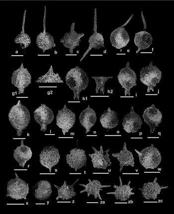
Scanning electron micrographs of radiolarians from QM section, Sepon district, Savannakhet province, central Laos. All scale bars: 100 µm (QM320: SEM number and PRC numbers are specimen numbers in the Palaeontological Research Centre of Mahasarakham University). (a–d) Futobari morishitai: (a) QM376PRC75; (b) QM3812PRC76; (c) QM36211PRC77; and (d) QM114PRC78. (e, f) Zadrappolus spp.: (e) QM112PRC79; and (f) QM31012PRC80. (g–r) Devoniglansus (?) seponensis n. sp. Thassanapak: (g) QM3913PRC81; (h) QM369PRC82; (i) QM3106PRC83; (j) QM3813PRC84; (k) QM373PRC85; (l) QM3104PRC86; (m) QM3107PRC87; (n) QM3117PRC88; (o) QM3615PRC89; (p) QM3623PRC90; (q) QM3631PRC91; (r) QM3617PRC92). (s, t) Pseudospongoprunum parvispina: (s) QM129PRC93; and (t) QM371PRC94. (u, v) Spumellaria gen. et sp. indet.: (u) QM246PRC95; and (v) QM256PRC96). (w, x) Zadrappolus cf. Z. lunaris: (w) QM365PRC97; and (x) QM36111PRC98. (y) Zadrappolus hitoeganensis, QM3114PRC99. (z–zb) Zadrappolus tenuis: (z) QM399PRC100; (za) QM361PRC101; and (zb) QM363PRC102). (zc) Zadrappolus yoshikiensis, QM242PRC103.

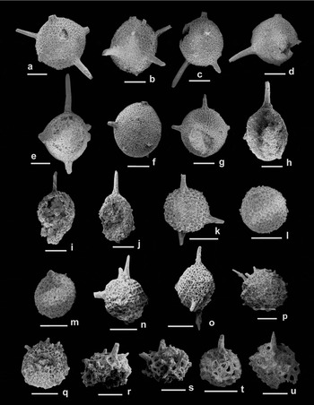
Scanning electron micrographs of radiolarians from HYC section, Sepon district, Savannakhet province, central Laos. All scale bars: 100 µm (HYC021: SEM number and PRC numbers are specimen numbers in the Palaeontological Research Centre of Mahasarakham University). (a–e) Futobari morishitai: (a) HYC021PRC104; (b) HYC026PRC105; (c) HYC037PRC106; (d) HYC028PRC107; and (e) HYC029PRC108. (f, g, o) Futobari sp.: (f) HYC24PRC109; (g) HYC025PRC110; and (o) QM45PRC503. (h–j) Pseudospongoprunum sagittatum: (h) HYC26PRC111; (i) HYC12PRC112; and (j) HYC211PRC113. (k) Futobari sp. cf. F. solidus, HYC031PRC114. (l, m) Zadrappolus hitoeganensis: (l) QM053PRC115; and (m) QM213PRC116. (n) Zadrappolus yoshikiensis, QM310PRC502. (p, q) Zadrappolus tenuis: (p) QM32PRC504; and (q) QM42PRC505. (r–u) Secuicollacta sp.: (r) HYC210PRC506; (s) HYC29PRC507; (t) HYC0226PRC508; (u) HYC0228PRC509.

Remarks: This species possesses the generic characteristics of Zadrappolus in having spherical latticed cortical shells. The shape and size of the pores are variable. As mentioned by Furutani (Reference Furutani1990), the original length of the spines is unknown as shown by the illustrated maximum length at 20 µm.The specimens shown here are identical to the type specimen of Z. hitoeganensis (Furutani, Reference Furutani1990).
Range and occurrence: ‘Upper’ Silurian (Ludlow–Pridoli) – Lower Devonian. This species has been reported from the Yoshiki Formation, Fukuji and Hitoegane areas in the Hida Gaien Terrane.
Zadrappolus sp. cf. Z. lunaris Noble, Reference Noble1994
Figure 8w, x
cf. 1990 Spumellaria gen. indet. sp. D Wakamatsu, Sugiyama & Furutani, p. 175, pl. 8, fig. 4.
cf. 1994 Zadrappolus lunaris Noble, pp. 32, 33, pl. 6, figs 7, 8; pl. 9, fig. 8.
cf. 2007 Zadrappolus lunaris Kurihara, p. 230, pl. 2, figs 8–10.
cf. 2013 Zadrappolus lunaris Nuramkhaan, Horie & Tsukada, p. 234, figs 13A–D.
Remarks: This species is distinguished from other species of Zadrappolus by possessing fewer and shorter external conical spines which taper to rod-shaped. Our specimens from the Sepon mine resemble the type specimen of Z. lunaris illustrated by Noble (Reference Noble1994), except that there are fewer spines than in the type.
Range and occurrence: ‘Upper’ Silurian (Ludlow–Pridoli).
Family SECUICOLLACTIDAE Nazarov & Ormiston, Reference Nazarov, Ormiston, Petrushevska and Stepanjants1984
Genus Rotasphaera Noble, Reference Noble1994
Type species: Rotasphaera marathonensis Noble, Reference Noble1994
Rotasphaera sp. cf. R. quadrata Noble, Reference Noble1994
Figure 7m
cf. 1994 Rotasphaera quadrata Noble, p. 21, pl. 2, figs 13–16, 19, 20.
Remarks: The shell of this species is quadrate in outline. There are 6–8 long straight spines with a high degree of tenting and with cylindrical and tapered primary spines. The specimen shown here is similar to the type specimen R. quadrata Noble (Reference Noble1994), except it has smaller pore frames compared to the latter.
Range and occurrence: ‘Upper’ Silurian (Ludlow–Pridoli).
Genus Secuicollacta Nazarov & Ormiston, Reference Nazarov, Ormiston, Petrushevska and Stepanjants1984
Type species: Secuicollacta cassa Nazarov & Ormiston, Reference Nazarov, Ormiston, Petrushevska and Stepanjants1984
Secuicollacta sp. cf. S. cassa Nazarov & Ormiston, Reference Nazarov, Ormiston, Petrushevska and Stepanjants1984
Figure 7n
cf. 1984 Secuicollacta cassa Nazarov & Ormiston, p. 75, pl. IV, fig. 5.
cf. 1994 Secuicollacta cassa? Noble, p. 23, pl. 1, figs 1, 2.
cf. 1995 Secuicollacta cassa Amon, Braun & Ivanov, p. 8, pl. 1, fig. 6; text-figs 13, 14
Remarks: The specimen shown here is not well preserved but similarity to the type specimen includes having thin, long and rod-shaped primary spines forming minor tenting. Unfortunately, the internal structure is covered by matrix which makes it difficult to determine the meshwork and secondary rod development.
Range and occurrence: ‘Upper’ Silurian (Ludlow–Pridoli).
Family SPONGURIDAE Haeckel, Reference Haeckel1862 sensu Noble, Reference Noble1994
Genus Devoniglansus Wakamatsu, Sugiyama & Furutani, Reference Wakamatsu, Sugiyama and Furutani1990
Type species: Devoniglansus unicus Wakamatsu, Sugiyama & Furutani, Reference Wakamatsu, Sugiyama and Furutani1990
Devoniglansus (?) seponensis new species Thassanapak.
Figure 8g–r
Diagnosis: This species has a subspherical and coarse spongy shell with two morphologically different polar spines. One is a short, small, rod-like to conical spine and the other is a larger, longer and distally trifurcated spine.
Description: Shell is subspherical in shape. Shell wall is slightly coarse and spongy and perforated by various sizes of numerous circular to oval pores. The apical spine originates from the pole of the shell and is short, small, rod-like to conical and tapers distally, sometimes showing shallow grooves at the base. The basal spine is larger, longer and more robust than the apical spine. The terminal part of the basal spine forms a shallow hole and is divided into three bladed spines, mainly triangular in outline and tapering distally.
Measurements: Based on measurement of 17 specimens (in micrometres) from a total of 36 specimens discovered from QM section.
Long axis average length = 170.31 μm
Wide axis average length = 154.71 μm
Apical spine average length = 44.71 μm
Basal spine average length = 53.48 μm
Comparison: Because the internal details of this species are uncertain, we tentatively assign it to Devoniglansus as it shows similarity to this genus in external shape as having a shallow hole at the basal spine and meshwork pattern. It may be distinguished from other Devoniglansus species by the different characteristics of the two polar spines. One is shorter, smaller and tapers into a cone; the other is longer, larger and thicker and is trifurcated distally.
Etymology: This species is named after the type locality at Sepon Mine in the Sepon District of Savannakhet Province, Lao PDR (Laos). All illustrated specimens of this new species are from the QM section in the small abandoned road-metal quarry at latitude 16° 56′ 09.538″ N, longitude 105° 56′ 10.331″ E.
Type materials: Holotype number QM3 913PRC81 (Fig. 8g), Paratype number H: QM3 69PRC82; I: QM3 106PRC83; J: QM3 813PRC84; K: QM3 73PRC85; L: QM3 104PRC86; M: QM3 107PRC87; N: QM3 117PRC88; O: QM3 615PRC89; P: QM3623PRC90; Q: QM3 631PRC91; R: QM3 617PRC92 (Fig. 8h–r).
Range and occurrence: ‘Upper’ Silurian (Ludlow–Pridoli) from this study. This species is abundant in the QM section in the Sepon Mine area, Lao PDR (Laos).
Genus Pseudospongoprunum Wakamatsu, Sugiyama & Furutani, Reference Wakamatsu, Sugiyama and Furutani1990
Type species: Pseudospongoprunum tazukawaensis
Wakamatsu, Sugiyama & Furutani, Reference Wakamatsu, Sugiyama and Furutani1990
Pseudospongoprunum parvispina Tetard, Noble & Danelian, Monnet & Lenz Reference Tetard, Noble, Danelian, Monnet and Lenz2015
Figure 8s
2015 Pseudospongoprunum parvispina n. sp. Tetard, Noble, Danelian, Monnet & Lenz, p. 11, figs 5 p–r, 6f.
Remarks: The specimen is identical to the type species of P. parvispina by having a large subspherical shell with two very small conical polar main spines. The conical spines gradually change into rod-like in the distal end. Its length is less than one-quarter of the shell length. The shell pores are spongy and have various sizes and shapes.
Range and Occurrence: Lower Gorstian (lower Ludlow), based on that reported by Tetard et al. (Reference Tetard, Noble, Danelian, Monnet and Lenz2015) from the Cape Phillips Formation, Bathrurst Island, Canadian Arctic and this study.
Pseudospongoprunum sagittatum Wakamatsu, Sugiyama & Furutani, Reference Wakamatsu, Sugiyama and Furutani1990
Figures 7h, i, 9h–j
1990 Pseudospongoprunum sagittatum Wakamatsu, Sugiyama & Furutani, p. 173, pl. 3, figs 1–4.
1991 Copiellintra sp. Aitchison, Hada & Yoshikura p. 87, fig. 3F
1996 Pseudospongoprunum sagittatum Aitchison, Hada, Ireland & Yoshikura, p. 60, pl. 1, fig. 5; pl. 3, fig. 9.
1996 Pseudospongoprunum sagittatum Suzuki, Takahashi & Kawamura, figs 4.1–3.
1997 Pseudospongoprunum sagittatum Umeda, p. 421, pl. 2, figs 1–5.
1998a Pseudospongoprunum sagittatum Umeda, fig. 9.5.
1998b Pseudospongoprunum sagittatum Umeda, p. 38, pl. 5, figs 1–4.
2000 Pseudospongoprunum sagittatum Kurihara & Sashida, p. 58, pl. 1, figs 8, 9.
2005 Pseudospongoprunum sagittatum Larghi, Cordey, Corradini, Gaetani & Nicora, p. 127, pl. 1, figs 5, 6, 8.
2009b Pseudospongoprunum sagittatum Kurihara, figs 4.1–3.
Remarks: This species is characterized by having a subspherical spongy shell with rod-like polar spines. Two polar spines are thick, unequal in length and sometimes blade-like at the proximal part. Structurally, its shell is rugby-ball shaped and mostly inflated on the side of the shorter spine.
Range and occurrence: ‘Upper’ Silurian (Ludlow–Pridoli). This species has been reported from the Gion yama, Konomori and Yokokurayama areas in the Kurosekawa Terrane, in the Kuzuryu area of the Hida Gaien Terrane and on Chios Island, Greece.
Pseudospongoprunum tazukawaensis Wakamatsu, Sugiyama & Furutani, Reference Wakamatsu, Sugiyama and Furutani1990
Figure 7j–l
1990 Pseudospongoprunum tazukawaensis Wakamatsu, Sugiyama & Furutani, p. 173, pl. 2, figs 1–4.
1996 Pseudospongoprunum tazukawaensis Aitchison, Hada, Ireland & Yoshikura, p. 60, pl. 2, figs 1–4.
2005 Pseudospongoprunum tazukawaensis Larghi, Cordey, Corradini, Gaetani & Nicora, p. 127, pl. 1, fig. 1.
Remarks: Shell has a subspherical spongy meshwork with two rod-like polar spines. This species is distinguished from P. sagittatum in having a more circular shell and smaller, thinner rod-like polar spines.
Range and occurrence: ‘Upper’ Silurian (Ludlow–Pridoli). This species has been reported from the Gion yama, Konomori and Suberidani areas in the Kurosekawa Terrane, the Kuzuryu area in the Hida Gaien Terrane and from Chios Island, Greece.
INCERTAE SEDIS
Genus Praespongocoelia Noble, Reference Noble1994
Type species: Spongocoelia parvusFurutani, Reference Furutani1990 emend. Noble, Reference Noble1994
Praespongocoelia parva (Furutani) emend. Noble, Reference Noble1994
Figure 7f
1990 Spongocoelia parvus Furutani, p. 47, pl. 9, figs 5–6, pl. 10, fig. 1.
1994 Praespongocoelia parva (Furutani) Noble, p. 38, pl. 7, figs 1–4.
2004 Praespongocoelia parva (Furutani) Kurihara, pl. 1, figs 29, 30.
2009a Praespongocoelia parva (Furutani) Kurihara, figs 3.50, 51.
Remarks: The specimen is similar to the original diagnosis of the type species described by Furutani (Reference Furutani1990) in having a subspherical shell and unequal conical polar spines which are offset from the poles. It can be distinguished from Pseudospongoprunum tazukawaensis in having a finer spongy meshwork shell.
Range and occurrence: ‘Upper’ Silurian (Ludlow–Pridoli). This species has been reported from the Fukuji area in the Kurosegawa Terrane, the Hitoegane Formation of the Hida Gaien Terrane, Japan and from the Marathon Uplift, west Texas, USA.
3.c. Age of the radiolarian faunas
Section CQ: Radiolarian faunas obtained from this section consist of Futobari morishitai Furutani, Futobari solidus Furutani, Zadrappolus yoshikiensis Furutani, Zadrappolus tenuis Furutani, Pseudospongoprunum sagittatum Wakamatsu, Sugiyama & Furutani, Pseudospongoprunum tazukawaensis Wakamatsu, Sugiyama & Furutani and rare specimens of Praespongocoelia parva (Furutani), Rotasphaera sp. cf. R. quadrata Noble, Secuicollacta sp. cf. S. cassa Nazarov & Ormiston and Praespongocoelia sp.
Section QM: Radiolarians from this section include Futobari morishitai Furutani, Zadrappolus yoshikiensis Furutani, Zadrappolus tenuis Furutani, Zadrappolus hitoeganensis Furutani, Zadrappolus sp. cf. Z. lunaris Noble, Pseudospongoprunum parvispina Tetard, Noble & Danelian, P. sp., Zadrappolus sp. and one new species; Devoniglansus (?) seponensis n. sp. Thassanapak.
Section HYC: The recovered radiolarians from this section are Futobari morishitai Furutani, Futobari sp. cf. F. solidus Furutani, Zadrappolus yoshikiensis Furutani, Zadrappolus tenuis Furutani, Zadrappolus hitoeganensis Furutani, Pseudospongoprunum sagittatum Wakamatsu, Sugiyama & Furutani, Futobari sp. and Secuicollacta sp.
Among them, Futobari morishitai, Zadrappolus yoshikiensis and Z. tenuis are the most characteristic species of the assemblage and are recovered from every section. They are representative species of the Zadrappolus yoshikiensis Assemblage of Furutani (Reference Furutani1990) who regarded the age of the assemblage to be latest Silurian – earliest Devonian. However, Noble (Reference Noble1994) and Kurihara & Sashida (Reference Kurihara and Sashida2000) point out the age of this assemblage is ‘late’ Silurian (Ludlow–Pridoli). Kurihara (Reference Kurihara2007) proposed the F. solidus – Z. tenuis assemblage as an equivalent of the Zadrappolus yoshikiensis Assemblage and inferred the age to be Pridoli–Pragian. Recently, zircon dating of the radiolarian-bearing Yoshiki Formation has shown that the lower limit of the Zadrappolus yoshikiensis – Futobari solidus Assemblage might be before the Ludlow (Nuramkhaan, Horie & Tsukada, Reference Nuramkhaan, Horie and Tsukada2013). However, based on Gradstein, Ogg & Hilgen (Reference Gradstein, Ogg and Hilgen2012), the age of the sequence from the Yoshiki Formation can be re-assigned to Pridoli.
In section CQ and HYC, the above species co-occur with Pseudospongoprunum sagittatum Wakamatsu, Sugiyama & Furutani. This is the characteristic species of the Pseudospongoprunum sagittatum Assemblage of Wakamatsu, Sugiyama & Furutani (Reference Wakamatsu, Sugiyama and Furutani1990) from the Kurosegawa Terrane who indicated its age as from ‘late’ Silurian to Middle Devonian. Noble (Reference Noble1994) compared this assemblage of Wakamatsu, Sugiyama & Furutani (Reference Wakamatsu, Sugiyama and Furutani1990) to her Devoniglansus unicus – Pseudospongoprunum(?) tauversi Zone from the Marathon Uplift, west Texas, USA. Based on the co-occurrence of conodonts, Noble (Reference Noble1994) concluded that the Pseudospongoprunum sagittatum Assemblage of Wakamatsu, Sugiyama & Furutani (Reference Wakamatsu, Sugiyama and Furutani1990) is ‘late’ Silurian (Ludlow–Pridoli).
In section QM, abundant Devoniglansus (?) seponensis n. sp. co-occur with Pseudospongoprunum pavispina, P. sp. and Zadrappolus sp. As mentioned by Noble & Aitchison (Reference Noble and Aitchison2000), the Postrotasphaerid Zone is distinguished from the lower zone of Long-spined inaniguttid Zone 2 and 3 by the absence of rotasphaerids and the predominance of inaniguttids such as Zadrappolus and Oriundogutta. The Devoniglansus–Pseudospongoprunum Assemblage also occurs within this zone. Conodonts from the west Texas locality show that this zone is not older than early Ludlow and not younger than late Pridoli. Pseudospongoprunum pavispina has been reported in the Gorstian in Canada which supports the lower extension to early Ludlow (Tetard et al. Reference Tetard, Noble, Danelian, Monnet and Lenz2015).
We therefore conclude that all three radiolarian-bearing sections in the Sepon Mine area may be assigned to a stratigraphic range from lower Ludlow to upper Pridoli.
4. Regional correlation and palaeogeography
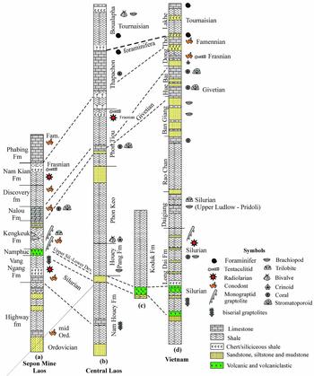
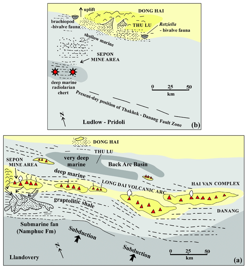
The discovery of red radiolarian cherts suggests deep to very deep marine conditions in the Sepon Mine Area of southern central Laos during Ludlow–Pridoli time. This contrasts with the shallow-marine facies containing brachiopods such as Retziella 80 km to the east in central Vietnam and in north-central Laos (Tong Dzuy Thanh et al. 2001, Reference Tong Dzuy, Phuong, Janvier, Hung, Cuc and Duong2013; Tran Van Tri & Vu Khuc, Reference Van Tri and Khuc2011). By the “latest Silurian Pridoli to Early Devonian Old Red Sandstone facies is present almost everywhere” (Tong Dzuy Thanh et al. Reference Tong Dzuy, Boucot, Rong and Fang2001, p. 323) in Vietnam and Laos, but is not recorded in the Sepon Mine area nor further north in central Laos where a brachiopod-bivalve-tentaculitoid fauna (Schizophoria, Cymostrophia, Plectodonta and ?Uniconus) in fine siliciclastics of the Houay Pang Formation is recorded (Figs 10, 11b) (Tran Van Ban, Reference Tran Van2000, p. 58). This deepening towards the south of the terrane is also recorded in our geochemical and field studies of the Upper Devonian strata in the region (Udchachon et al. Reference Udchachon, Thassanapak, Feng and Burrett2017).
Regional correlation of Ordovician–Devonian stratigraphic units (a) mapped around Sepon Mine area, Laos (adapted from Cannell et al. Reference Cannell, Stewart, Williams, Wallace, Burrett and Davis2015); (b) central Laos north of the Sepon Mine area (adapted from Tran Van Ban, Reference Tran Van2000); (c) eastern central Laos (adapted from Tran Van Ban, Reference Tran Van2000); and (d) central Vietnam (adapted from Vu Khuc, Reference Vu1986; Tran Van Tri & Vu Khuc, Reference Van Tri and Khuc2011).

Speculative non-palinspastic, palaeogeographic map of southern Truong Son Terrane in central Laos and central Vietnam. (a) Llandovery and (b) Ludlow–Pridoli based on many sources (see text). Note north arrow is present-day north. Ludlow–Pridoli terrestrial ‘Old Red Sandstone Facies’ is generally found in northern central Laos and extensively in Vietnam, and is replaced by shallow-marine facies and then deep-water sedimentation further south. Radiolarian symbol as in Figure 10. Presumed land is shown in yellow. Dots indicate sandstones and dashes are shales.

In the Llandovery, deep-water graptolitic shales are found northeastwards to the Dong Hai area of Vietnam. Wenlock-aged radiolarians and graptolites from cherts in the Long Dai Formation from Thu Lu, Vietnam, 80 km east of our collection site (Fig. 11), were collected and the radiolaria illustrated by Tran Van Tri and T. Kurihara (Tran Van Tri & Vu Khuc, Reference Van Tri and Khuc2011, pp. 63–65). The radiolarian fauna consists of ?Inanigutitidae, ?Rotasphaera sp. and doubtfully identified species of Stigmosphaerostylus. The first two taxa are present at Sepon but Stigmosphaerostylus is absent. The Vietnamese cherts overlie andesites and deep-water Upper Ordovician siliciclastics containing a psychrospheric trilobite fauna that includes Nileus, Cyclopyge and Microparia (Tran Van Tri & Vu Khuc, Reference Van Tri and Khuc2011, p. 63). The andesites and associated volcaniclastic rocks in the Long Dai Formation in Vietnam have a stratigraphic range of Upper Ordovician – Wenlock and these have been included in the Long Dai Volcanic Arc by Le Van De (Reference Le Van De1997). Several Silurian granitoids are mapped in the eastern part of the Thakhek–Danang Suture (Carter et al. Reference Carter, Roques, Bristow and Kinney2001) and one of them (the volcanic-arc Hai Van Complex, Fig. 1) has a Llandovery age (438 +/− 3.5 Ma, Shi et al. Reference Shi, Lin, Fan, Deng, Cong, My–Dung, Zhu and Wang2015). The Long Dai Volcanic Arc follows the southern margin of the Truong Son and grades into agglomerates and tuffs of the Namphuc Formation submarine Fan in the Sepon Mine area (Fig. 11a). The Namphuc Formation varies in thickness, but is dominantly volcanic and volcaniclastic in the east of the mine area and has mainly non-volcanic clasts in the west. Andesitic volcanics are mapped in the east of the mine area (Smith, Reference Smith2009). The submarine fan of the Namphuc Formation received clasts and ash from an andesitic volcanic arc (Smith, Reference Smith2009). Lithic correlates of the upper Llandovery Vang Nang Formation limestone have not been found elsewhere in Laos nor in Vietnam, and the majority of Upper Ordovician – Wenlock sedimentary sequences of the southern Truong Son Terrane in Vietnam and Laos are deep-water marine (e.g. Williams et al. Reference Williams, Komatsu, Tanaka, Nguyen, Zalasiewicz, Vandenbrooke, Wallis and Perrier2016).
The Long Dai Volcanic Arc was initiated during Late Ordovician time, continued into Wenlock time and includes the volcanic-arc granites of the Hai Van Complex in Vietnam (Fig. 11a). There is no record of significant Siluro-Devonian volcanism or plutonism in the southern Truong Son Terrane after Wenlock time (Fig. 10), suggesting that northwards subduction under the terrane, paralleling the present-day Thakhek–Danang Suture, lasted for about 20 Ma (Tran Van Tri, Reference Van Tri1977; Shi et al. Reference Shi, Lin, Fan, Deng, Cong, My–Dung, Zhu and Wang2015). The active continental margin identified in this study is a westwards extension of the Tamky–Phuoc Son Suture of central Vietnam (Hai Thanh Tran et al. Reference Hai Thanh Tran, Halpin, Manaka, Meffre, Kit Lai, Lee and Hai Van Le2014).
Hada et al. (Reference Hada, Ishii, Landis, Aitchison and Yoshikura2001) described a similar Silurian radiolarian fauna from the Kurosegawa Terrane of Japan. They suggest that this terrane was within the Colania–Lepidolina territory during Permian time, possibly close to the eastern margin of the Indochina – East Malaysia – South China continental block. The Kurosegawa Terrane may therefore have been close to our Laotian fauna during Silurian time and possibly even contiguous with the active southern margin of the Truong Son Terrane.
5. Conclusions
This study is a significant addition to the inventory of Silurian radiolarian faunas. Apart from one new species, the fauna is generally cosmopolitan but has greatest specific affinity with faunas from Japan and Canada. The Sepon Mine Ludlow–Pridoli radiolarian red cherts, of presumed deep-marine origin, contrast with the shallow-marine shelly faunas 85 km to the north and NE in central Laos and Vietnam, and are in marked contrast to the terrestrial ‘Old Red Sandstone’ facies found across most of the northern Truong Son Terrane to the Song Ma Terrane and into the South China Terrane.
The correlation of the volcaniclastics of the Namphuc Formation submarine fan with andesitic volcanics further east in Laos and with volcanics and volcanic-arc granitoids in Vietnam suggest that the Late Ordovician – Wenlock Long Dai Volcanic Arc (Le Van De, Reference Le Van De1997) was the result of northwards subduction under the Truong Son Terrane close to and parallel with the Permian–Recent Thakhek–Danang Shear Zone (Shi et al. Reference Shi, Lin, Fan, Deng, Cong, My–Dung, Zhu and Wang2015). The Sepon Silurian therefore constitutes the southern margin of the Truong Son Terrane and a westwards extension of the Tamky Suture of central Vietnam (Tran Van Tri, Reference Van Tri1977; Hai Thanh Tran et al. Reference Hai Thanh Tran, Halpin, Manaka, Meffre, Kit Lai, Lee and Hai Van Le2014).
Acknowledgements
This research is supported by Mahasarakham University. We are indebted to the past and present staff of LXML (MMG) at Sepon Mine for their help and hospitality, especially Stuart Smith, Paul Burrell, James Cannell, Bounoum Bouthathep, Derek Backhouse, Vila Phoutsavath, Xaynahalath (Bot) Phinsavanh, Vandone Photisone, Vilay Photivong, Thavisone Inthivong, Juanito Salamat, Olivia Arifin and Peng (Zippy) Zhang. The assistance of Sam Ekins, Tran Van Tri and the late Srixomcheun Duagsurigna is also appreciated. The manuscript was substantially improved by helpful reviews from Martin Tetard and Johnathan Aitchison.