INTRODUCTION
Making inventories and monitoring biodiversity are crucial to identifying the natural processes and the human activities that affect ecosystems. The loss of biodiversity should be of considerable concern to everyone because it threatens the functioning of a system (Rigby et al., Reference Rigby, Iken and Shirayama2007). There is compelling evidence that climate is changing and this change is driving important alterations in the composition and structure of a very diverse array of natural assemblages: terrestrial, marine and aquatic (Cruz-Mota et al., Reference Cruz-Mota, Miloslavich, Palomo, Iken, Konar, Pohle, Trott, Benedetti-Cecchi, Herrera, Hernandez, Sardi, Bueno, Castillo, Klein, Guerra-Castro, Gobin, Gomez, Riosmena-Rodriguez, Mead, Bigatti, Knowlton and Shirayama2010). Destruction of natural habitats, loss of strong interacting species (such as habitat formers and keystone species), introduction of non-native species (Orensanz et al., Reference Orensanz, Schwindt, Pastorino, Bortolus, Casas, Darrigran, Elias, López Gappa, Obenat, Pascual, Penchaszadeh, Piriz, Scarabino, Spivak and Vallarino2002), over-exploitation of natural resources, such as overfishing (Jackson et al., Reference Jackson, Kirby, Berger, Bjorndal, Botsford, Bourque, Bradbury, Cooke, Erlandson, Estes, Hughes, Kidwell, Lange, Lenihan, Pandolfi, Peterson, Steneck, Tegner and Warner2001), urban pollution (Díaz et al., Reference Díaz, López Gappa and Piriz2002) and climate change (Smith et al., Reference Smith, Fong and Ambrose2006) are all potential threats to biodiversity. The first step towards understanding these complexities, on the large scale, is to investigate global patterns of biodiversity (i.e. taxonomic composition and diversity of assemblages) over a broad range of spatial scales, and to develop a sustainable network for long-term monitoring (Rigby et al., Reference Rigby, Kato and Shirayama2000). To detect changes in natural communities, and unequivocally relate them to anthropogenic impacts or climate disruptions, proper baseline data are of utmost importance (Cruz-Mota et al., Reference Cruz-Mota, Miloslavich, Palomo, Iken, Konar, Pohle, Trott, Benedetti-Cecchi, Herrera, Hernandez, Sardi, Bueno, Castillo, Klein, Guerra-Castro, Gobin, Gomez, Riosmena-Rodriguez, Mead, Bigatti, Knowlton and Shirayama2010), as well as to have knowledge about the processes governing the patterns observed locally in rocky intertidal habitats (Underwood, Reference Underwood2000). In this sense, it is important to perform experiments to test hypotheses about the processes that structure and maintain diversity in such communities. Alternatively, standardized global monitoring programmes can be put in place to assess changes in biodiversity and relate those changes to possible anthropogenic causes (Darling & Côté, Reference Darling and Côté2008).
In the particular case of coastal ecosystems, studies on benthic community structure are an adequate tool to assess the impact caused by pollution (Díaz et al., Reference Díaz, López Gappa and Piriz2002), mainly due to the reduced mobility of benthic species, which cannot avoid the potentially dangerous environmental conditions. For instance, on the southern Atlantic shores, the structure of the intertidal community characterized by the tiny mussel Brachidontes rodriguezii, has been successfully used to detect environmental impact due to domestic sewage (López Gappa et al., Reference López Gappa, Tablado and Magaldi1990, Reference López Gappa, Tablado and Magaldi1993; Vallarino, Reference Vallarino2002; Vallarino et al., Reference Vallarino, Rivero, Gravina and Elías2002). Therefore, baseline information on benthic community structure is critical to avoid confounding the consequences of an impact, given the high level of variability in natural assemblages (Smith & Simpson, Reference Smith and Simpson1995; Gelin et al., Reference Gelin, Gravez and Edgar2003). Several authors have pointed out that pre-impact data are essential to understand effects of pollution such as an oil spill (Paine et al., Reference Paine1996). The problem is that the databases available at the moment are restricted to a few regions and locations throughout the world (Cruz-Motta et al., Reference Cruz-Mota, Miloslavich, Palomo, Iken, Konar, Pohle, Trott, Benedetti-Cecchi, Herrera, Hernandez, Sardi, Bueno, Castillo, Klein, Guerra-Castro, Gobin, Gomez, Riosmena-Rodriguez, Mead, Bigatti, Knowlton and Shirayama2010). Despite the ecological and economic importance of Patagonian coasts, its benthic biodiversity remains poorly understood, except for some records in the literature (Olivier et al., Reference Olivier, Paternoster and Bastida1966; Bertness et al., Reference Bertness, Crain, Silliman, Bazterrica, Reyna, Hidalgo and Farina2006; Cuevas et al., Reference Cuevas, Martin and Bastida2006; Kelaher et al., Reference Kelaher, Castilla, Prado, York, Schwindt and Bortolus2007; Torres & Caille, Reference Torres and Caille2009; Irigoyen et al., Reference Irigoyen, Trobbiani, Sgarlatta and Raffo2010; Miloslavich et al., Reference Miloslavich, Klein, Díaz, Henández, Bigatti, Campos, Artigas, Castillo, Penchaszadeh, Eneill, Carranza, Retana, Díaz de Astarloa, Lewis, Yorio, Piriz, Rodríguez, Yoneshigue-Valentín, Gamboa and Martín2011; Silliman et al., Reference Silliman, Bertness, Altieri, Griffin, Bazterrica, Hidalgo, Crain and Reyna2011; Sueiro et al., Reference Sueiro, Bortolus and Schwindt2011). In this context, the rocky shore of Punta Este (Golfo Nuevo, Patagonia) was selected as one of the sites distributed along the world for the Census of Marine Life (CoML), an international science programme for inventorying and monitoring marine biodiversity all over the world (finished in 2010). The main goal of this project was to establish an initial census for future comparisons and monitoring programmes over time (Iken & Konar, Reference Iken and Konar2003). Through the combination of a simple, cost-efficient and intentionally low-tech sampling protocol and a hierarchically nested design, the project NaGISA (Natural Geography in Shore Areas), carried out a series of globally-distributed standard transects in more than 250 sites within 28 countries. At present, the NaGISA database, growing since 2003, is available through the Ocean Biogeographic Information System (OBIS) and contains nearly 54,666 records for 2867 taxa (Plos collections, 2011). Based on the data generated by the NaGISA project, the aim of the present study was directed to describe the benthic assemblages in terms of richness, specific and functional composition at different levels (intertidal and subtidal) of Punta Este rocky shore, as baseline data that could be useful for future temporal monitoring programmes, allowing to detect changes in biodiversity or ecosystem function due to anthropogenic impacts or environmental changes.
MATERIALS AND METHODS
Study area
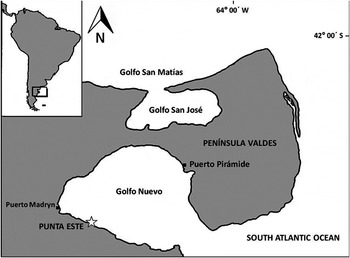
The rocky shore of Punta Este (42°47′5.7″S64°57′7.3″W) is ~8 km from the city of Puerto Madryn, located in northeast Patagonia, Argentina and on the west coast of Golfo Nuevo (Figure 1). The region is characterized by extreme weather conditions. A characteristic of the Patagonian climate is the predominance of winds from the west. Westerly winds are characterized not only by the persistence during the year but also by their intensity (Paruelo et al., Reference Paruelo, Beltran, Sala and Golluscio1998), recording an annual mean speed of 16.6 km/h and reaching up to 90 km/h (Labraga & De Davies, updated Reference Labraga and De Davies2013). Also low humidity content characterizes this wind, so most of the region belongs to the arid category (Paruelo et al., Reference Paruelo, Beltran, Sala and Golluscio1998). The mean annual precipitation over the region is 235.9 mm (Labraga & De Davies, updated Reference Labraga and De Davies2013) and the mean annual temperature is 13.4°C with annual amplitude reaching 40°C and daily variations of up to 30°C. These strong, dry winds combined with low rainfall, make the Patagonian intertidal the place with the highest desiccation stress recorded for rocky shore communities (Bertness et al., Reference Bertness, Crain, Silliman, Bazterrica, Reyna, Hidalgo and Farina2006). The tide regime is semidiurnal in the zone and the mean amplitude is 3.8 m, but spring tides can reach 5.7 m. Coastal shoreline is predominantly of consolidated limestone, locally known as tosca. Subtidal shallow waters present less thermal variation than the intertidal, recording surface water temperature of 18°C at the end of the summer and minimum of 8°C in spring (Rivas & Beier, Reference Rivas and Beier1990), and more homogeneous environmental conditions resulting in less physical stress.
Sampling site (star) at Punta Este, Golfo Nuevo, Patagonia, Argentina.

Sampling protocol
Samples were collected during November 2006 at low tide, following the NaGISA protocol (see Rigby et al., Reference Rigby, Iken and Shirayama2007 for further details). Six levels were sampled: the high (hereafter HT); middle (hereafter MT) and low intertidal zone (hereafter LT); and 1 m depth (hereafter 1 m) (only exposed during spring tides); 5 m depth (hereafter 5 m); and 10 m depth (hereafter 10 m) in the subtidal zone. The levels in the intertidal zone were selected noting patterns in the distribution coverage of the most conspicuous benthic invertebrates and algae and topography that determines different exposure to water. The HT was defined where barnacles and tiny mussels were abundant; this is the zone most exposed to desiccation during low tides. The MT was defined as the tidal zone covered by a compact tiny mussel bed. The LT was defined as the zone that was dominated by dense coralline algal cover and above the low tide limit. Subtidal levels were selected by measuring depth with a digital depth-meter during low tide (1 m, 5 m, 10 m). For invertebrates samples were taken randomly at each level by five 25 × 25 cm quadrats along a 30 m transect parallel to the shoreline. All organisms were carefully removed from the substratum with a scraper, placed into mesh bags, fixed in 10% formalin and later transferred to 70% ethanol. At the laboratory each sample was sorted through a sieve of 0.5 mm mesh. Organisms retained were identified to the lowest possible taxonomic level and counted to calculate abundance (ind.m−2). Each organism from each level was assigned to a functional group according to their feeding type: suspension feeder (SF); deposit–detritus feeder (DF); predator–scavenger (PS); grazer (G); and opportunist (O). A voucher of each specimen collected was deposited in the CENPAT Invertebrate Collection with numbers CNP_INV_0101 to 0136. The mytillids Brachidontes rodriguezii and Brachidontes purpuratus, the latter historically placed into the genus Perumitylus, form a ‘mussel matrix’ and were counted and grouped together under the name of ‘tiny mussels’ because of their morphological similarities, high phenotypic variability (Rechimont, Reference Rechimont2011; Trovant et al., Reference Trovant, Ruzzante, Basso and Orensanz2013) and shell damage during sampling procedure that make it difficult to discriminate between species. In the 10 m depth only two samples were possible on hard substrate due to the randomness of the sampling and the characteristics of hard substrates in the studied area, so soft bottoms were presented in the other three quadrats, and were sampled following the NaGISA protocol for hard bottoms as in the other quadrats.
Algae samples were collected following the same protocol and routine (Rigby et al., Reference Rigby, Iken and Shirayama2007), but using a 50 × 50 cm quadrat. Algae were removed, placed in plastic bags and stored in a cooler until they were frozen at −18°C. Algae were identified in the laboratory to the lowest possible taxonomic level. Dry weight of each species or higher taxa were measured to the nearest 0.01 g in a Sartorius analytical balance after stove samples at 60°C for about 24 h or up to the weight was constant. Because of the precision of the balance samples with less than 0.01 g dry weight were not detected. Algae were not present in the 10 m level, due to the quadrats falling onto sandy bottoms or bare hard substrate.
Data analysis
Multivariate approaches were used to examine invertebrate assemblages in the six different levels. In order to investigate differences in assemblage structure the one-way analysis of similarity (ANOSIM) procedure was used (Clarke, Reference Clarke1993). A graphical comparison of assemblage structure between levels was produced by ordination of the data using two-dimensional non-metric multidimensional scaling (nMDS, Clarke, Reference Clarke1993). In order to identify taxa that dominated or characterized the levels sampled, a similarity percentage analysis (SIMPER) was performed (Clarke, Reference Clarke1993). Data were fourth-root transformed and the Bray–Curtis coefficient was used as a resemblance parameter (Clarke, Reference Clarke1993).
In addition, taxonomic richness, diversity (Shannon's index H), and total abundance (ind.m−2) were compared between intertidal and subtidal levels using the non-parametric Kruskal–Wallis test because variances were heterogeneous and could not be stabilized after different transformations.
RESULTS
Invertebrate samples
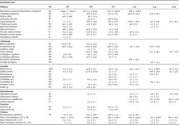
Among invertebrates, a total of 16,344 individuals were counted encompassing 35 species or higher taxa. In terms of species, the dominant phyla were molluscs (12 species), arthropods (eight species) and annelids (eight species). Also the presence of echinoderms (four species), nemerteans (two species) and cnidarians (one specie) were detected (Table 1). Throughout all levels sampled in the intertidal zone (HT, MT, LT), as well as in 1 m samples, the tiny mussels Brachidontes rodriguezii and Brachidontes purpuratus were dominants, their abundances being several orders of magnitude higher than those accounted for in the rest of the sampled taxa (Table 1). Although the non-native barnacle Balanus glandula was observed in all levels at the intertidal zone, its highest abundance was recorded on HT samples (Table 1). Other taxa showing high abundances at intertidal samples were the gastropod Siphonaria lessoni, the isopod Exosphaeroma sp., the tanaid Tanais dulongii and the polychaete Syllidia armata (Table 1). At the subtidal level, 1 m samples, showed high abundances of the bivalve Lithophaga patagonica while the gastropod Tegula patagonica, and the polychaete Platynereis sp. showed to be abundant at all subtidal levels (Table 1). Finally, echinoderms were almost exclusively present in the subtidal samples (Table 1).
Mean values (±SD) of abundance (ind.m−2), total abundance (ind.m−2), diversity (H) and taxonomic richness (S) of invertebrates found in each level sampled.

Levels are indicated as follows: high (HT), middle (MT) and low (LT) intertidal and 1 m depth (1 m), 5 m depth (5 m) and 10 m depth (10 m). The functional group (FG) of each taxon is indicated as: suspension feeder (SF), deposit–detritus feeder (DF), grazer (G), predator–scavenger (PS), opportunist (O) and all functional groups (AFG).
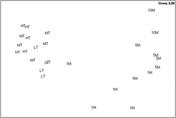
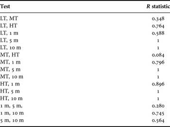
The multivariate analysis indicated that the assemblage composition of benthic invertebrates was different among levels (Figure 2; Table 2). We found significant differences between all pairs of samples from intertidal and subtidal zones and in the case of the intertidal, samples from HT showed to be different from samples from LT, while in the case of subtidal, samples from 1 m differed from 10 m samples (P < 0.001; Table 2).
Non-matric multidimensional scaling ordination for the invertebrate assemblages in the different levels sampled in the shore of Punta Este based on Bray–Curtis similarities and square root transformed data. HT (empty diamond); MT (empty square); LT (empty circle); 1 m (solid diamond); 5 m (solid circle) and 10 m (solid square).

Summary of ANOSIM results for Punta Este shore: (P<0.001 for all tests). R Global for level 0.6.

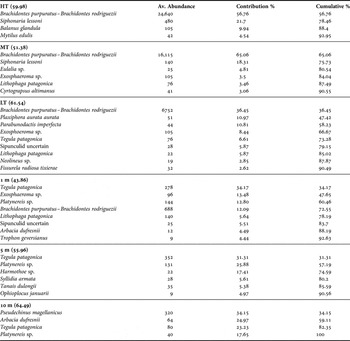
The SIMPER analysis showed the characteristic taxa from each level (Table 3).While the mussels Brachidontes rodriguezii and Brachidontes purpuratus characterized intertidal levels, the gastropod Tegula patagonica was characteristic from 1 m and 5 m samples and the sea urchin Pseudechinus magellanicus was from 10 m samples.
Summary of SIMPER results for Punta Este shore: average abundance (ind.m−2) of typifying species in each level, their contribution (%) to the within-group similarity, and cumulative total (%) of contributions (90% cut-off).

Diversity and total abundance differed significantly between intertidal and subtidal levels, while subtidal samples were more diverse than intertidal samples (Kruskal–Wallis test H = 20.61, P ≤ 0.001; Table 1), intertidal showed higher total abundances (Kruskal–Wallis test H = 21.05, P ≤ 0.001; Table 1). On the other hand, no differences were observed for species richness between intertidal and subtidal samples (Kruskal–Wallis test H = 5.133787, P = 0.399).
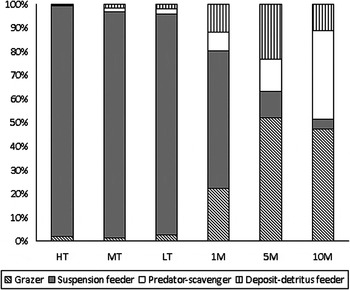
Based on the mean abundances of each feeding type, the intertidal level was clearly dominated by suspension feeders while in 1 m samples this feeding group showed the same percentage as that of grazers. On the other hand, 5 m and 10 m samples were dominated by grazers and predators (Figure 3). There was a tendency of decreasing suspension feeders species and increasing of grazers and predators from intertidal to subtidal level.
Percentage proportion of the different feeding types present in each sampled level.

Algae samples
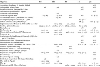
From the algae samples, 29 species or higher taxa were identified and weighted (Table 4). Corallina officinalis was the main algae species in the intertidal level with the higher biomass (HT: 254.99 g.m−2, MT: 402.85 g.m−2, LT: 76.17 g.m−2) (Table 4). This alga forms a matrix that retains humidity and is related to a great abundance of invertebrates (see Table 1). In the LT level the invasive algae Undaria pinnatifida was present with a biomass of 24.16 g.m−2 . The 1 m level was characterized by Dictyota dichotoma with 14.64 g.m−2 and U. pinnatifida (Table 4). Despite D. dichotoma presented high biomass in the 5 m level also (23.08 g.m−2), Codium vermilara showed the highest biomass of native algae in this level (81.80 g.m−2) (Table 4). Additionally, in the 5 m level the biomass of U. pinnatifida was elevated, with values of 442.74 g.m−2 . At the 10 m level no algae were registered as quadrats fell onto soft bottom or bare hard substrate.
Mean values (±SD) of biomass (g of dry weight.m−2) and non-detected weights (n/d; less than 0.01 g of dry weight.m−2) of algae found in each level sampled.

Levels are indicated as follows: high (HT), middle (MT) and low (LT) intertidal and 1 m depth (1 m) and 5 m depth (5 m).
DISCUSSION
The rocky shore of Punta Este, selected as one of the sites distributed along the world for the Census of Marine Life, showed a high benthic biodiversity which encompassed 64 taxa of invertebrates and algae. Given the characteristics of the standardized sampling protocol used, it could be highlighted that the composition of invertebrate assemblages showed a vertical zonation where the greatest differences were observed between intertidal and subtidal samples. In this sense, it was found that the high intertidal was dominated by the tiny mussels Brachidontes purpuratus and Brachidontes rodriguezii, forming a conspicuous mussel bed (mussel matrix), while in the lowest levels the tiny mussel bed disappeared and the zone is dominated by a mixture of bigger mussels and the coralline alga Corallina officinalis. Rocky intertidal communities on Argentinean coasts are structured by the dominance of mytillids, and particularly by B. rodriguezii in the warm temperate and B. purpuratus in the cold-temperate sector, coexisting in the same beds along the transition zone (41–43°S) (Penchaszadeh, Reference Penchaszadeh1973; Adami et al., Reference Adami, Tablado and Sodor2008; Trovant et al., Reference Trovant, Ruzzante, Basso and Orensanz2013; Van der Molen et al., Reference Van der Molen, Márquez, Idaszkin and Adami2013). These mussel beds are critical in the structure and function of the intertidal community because light, temperature, wave action and potentially lethal desiccation stress are significantly reduced within them, while sediment loading and relative humidity increase (Seed & Suchanek, Reference Seed, Suchanek and Gosling1992; Silliman et al., Reference Silliman, Bertness, Altieri, Griffin, Bazterrica, Hidalgo, Crain and Reyna2011). Although diversity may decline on the rocky surface due to mussel dominance, the development of the beds creates a secondary substratum with enriched infaunal and epibenthic assemblages (Dittman & Robles, Reference Dittman and Robles1991; Lohse, Reference Lohse1993; Ragnarsson & Raffaelli, Reference Ragnarsson and Raffaelli1999). Likewise, the turf-forming coralline alga also provides a more benign habitat for the recruitment and survival of several invertebrate species (Kelaher et al., Reference Kelaher, Castilla, Prado, York, Schwindt and Bortolus2007). Due to the high abundance of the tiny mussels registered, the intertidal zone was characterized by suspension-feeders. This kind of feeding is favoured in this environment due to the plankton abundance in the waters around the rocky shores and the wave movement that contributes to the nutrient circulation (Bertness, Reference Bertness1999).
With regard to subtidal samples, the 1 m level showed a merged invertebrate assemblage with both components of LT and 5 m samples. Even though this level was characterized by the grazer gastropod Tegula patagonica and that all feeding types were present, the suspension feeders remained dominant. On the other hand, 5 m and 10 m samples clearly differed in composition assemblages from intertidal. At subtidal zone the tiny mussels suspension feeders were not present, and that zone was dominated by grazers and predator–scavenger. That dominance of grazers may be associated with the macroalgae, composed mainly of the invasive species Undaria pinnatifida. The dominance of herbivore gastropods in Punta Este are concordant to some other mid to high-latitude assemblages (from LMEs: Beaufort Sea and Gulf of Alaska), which represent more than 90% within the gastropods; such dominance in herbivores with high densities could be related to high macroalgal biomass (Miloslavich et al., in press). Irigoyen et al. (Reference Irigoyen, Trobbiani, Sgarlatta and Raffo2010) have found that the presence of U. pinnatifida is associated with increased invertebrates species richness and diversity, and could potentially produce a bottom-up effect on local food chains by increasing the abundance of prey for a wide range of predators. An example are the sea Arbacia dufresnii and Pseudechinus magellanicus that fed on the invasive kelp U. pinnatifida, whereas the snail T. patagonica scraped off biofouling adhered to its surface (Teso et al., Reference Teso, Bigatti, Casas, Piriz and Penchaszadeh2009). We observed this tendency in our results, so the increase of biodiversity in the subtidal assemblage might be related to the presence of U. pinnatifida and less environmental physical stress.
Differences on assemblage's composition, together with the higher total abundance and the lower diversity of the intertidal with regard to subtidal zone is likely to be the result of a trade-off between the individual physiological tolerance with the relative contribution of positive and negative interaction operating. In this sense, it has been proposed that under harsh physical conditions, positive interactions should be the main forces structuring the assemblage while as physical conditions decrease competitive interactions should be dominant structuring forces (Bertness & Callaway, Reference Bertness and Callaway1994). Previous experimental researches on Patagonian rocky shores have demonstrated that: (1) the thick mussel matrix protects associated animals from lethal, wind-driven desiccation stress; and (2) maintenance of the whole-community diversity depends exclusively on facilitation by foundation species, rather than keystone predation, under the intense climate stress registered (Bertness et al., Reference Bertness, Crain, Silliman, Bazterrica, Reyna, Hidalgo and Farina2006; Silliman et al., Reference Silliman, Bertness, Altieri, Griffin, Bazterrica, Hidalgo, Crain and Reyna2011).
Experimental research is required to have a clear picture of the mechanism underlying assemblage patterns on Punta Este rocky shores. However, it is likely that the differences registered between intertidal and subtidal assemblages could be explained in part by an increase in physical stress at the intertidal with low predation pressure that promotes positive interactions (amelioration of stress by founding species, such as the mytillid matrix), while in the subtidal the increase in consumers and decrease of physical stress could lead to negative interactions, such as predation, that could lead to associational defences.
Our results add to the information generated in the last ten years by the NaGISA project, a series of globally-distributed standard transects in more than 250 sites within 28 countries that produced several papers (Plos collections, 2011). Data about the benthic diversity and assemblage of Punta Este rocky shore could be useful for a long-term monitoring programme to detect community changes due to anthropogenic activities or environmental changes and to test the factors that structure this assemblage. In this sense the recently created South American Research Group in Coastal Ecosystems (SARCE) will continue monitoring marine diversity and biomass in more than 50 localities using a more dynamic and non-invasive protocol than that used in the present work, encouraging the study of the ecosystem function and human impact on South American rocky shores.
ACKNOWLEDGEMENTS
We are grateful to A. Irigoyen who generously helped in the subtidal sampling, F. Dellatorre and E. Gomez Simes who kindly helped in the identification of decapods and P. Raffo who helped to identify some algae. V. Böekenhans, F. Arrighett; and J. Giménez helped in the sorting of species. This work was part of the NaGISA project of the Census of Marine Life at Puerto Madryn site.
FINANCIAL SUPPORT
We thank the Census of Marine Life and the Nagisa project for funding this work.