1. Introduction
Many tectonic and magmatic features have long been recognized as reflecting an Early Ordovician deformation event along the northern Gondwana margin (Teichmüller, Reference Teichmüller1931; Stille, Reference Stille1939; Arthaud, Reference Arthaud1963; Den Brok, Reference Den Brok1989; Diaz Garcia, Reference Diaz Garcia2006; Romão et al. Reference Romão, Coke, Dias and Ribeiro2005; Casas, Reference Casas2010). These include (1) folds affecting the pre-Middle Ordovician succession; (2) an angular unconformity between Lower Ordovician and Middle Ordovician sedimentary rocks; (3) an important erosional phase indicated by conglomerates that rest on the unconformity; and (4) widespread Middle Ordovician calc-alkaline magmatism with intrusive and extrusive products. In the last decade, many studies have reconstructed the Ordovician geodynamic setting of several sectors of the NE Gondwana margin, based mainly on the geochemical signature of magmatic rocks. Such reconstructions have been made for the SW Alps (Zurbriggen, Reference Zurbriggen2017), the Calabro-Peloritan arc (Trombetta et al. Reference Trombetta, Cirrincione, Corfu, Mazzoleni and Pezzino2004), Corsica (Rossi, Oggiano & Cocherie, Reference Rossi, Oggiano and Cocherie2009), the Maures Massif (Lancelot, Moussavou & Delor, Reference Lancelot, Moussavou and Delor1998), the French Massif Central (Alexandre, Reference Alexandre2007), the Pyrenees (Laumonier, Reference Laumonier, Canérot, Colin, Platel and Bilotte2008; Casas et al. Reference Casas, Castiñeiras, Navidad, Liesa and Carreras2010), the southwestern Iberian Peninsula (Solà et al. Reference Solà, Pereira, Williams, Ribeiro, Neiva, Montero, Bea and Zinger2008), Turkey (Okay, Satir & Shang, Reference Okay, Satir and Shang2008), South China (Li et al. Reference Li, Pei, Li, Pei, Liu, Chen, Zhang, Wang and Xu2016) and Sardinia (Oggiano et al. Reference Oggiano, Gaggero, Funedda, Buzzi and Tiepolo2010; Gaggero et al. Reference Gaggero, Oggiano, Funedda and Buzzi2012). The main sectors of northern Gondwana margin where tectonic studies have been undertaken are (1) SW Sardinia (specifically the Iglesiente area; Fig. 1), where local Ordovician deformation was first identified (the “Sardic Unconformity” of Teichmüller, Reference Teichmüller1931 or the “Sardic Phase” of Stille, Reference Stille1939) and where, more recently, pre-Middle Ordovician E–W-trending folding and thrusting have been reported (Pasci et al. Reference Pasci, Pertusati, Salvadori and Murtas2008); and (2) the eastern Pyrenees, where Early–Middle Ordovician folding pre-dates an angular unconformity between the Cambrian – Lower Ordovician and Upper Ordovician series (Casas et al. Reference Casas, Queralt, Mncos and Gratacòs2012).
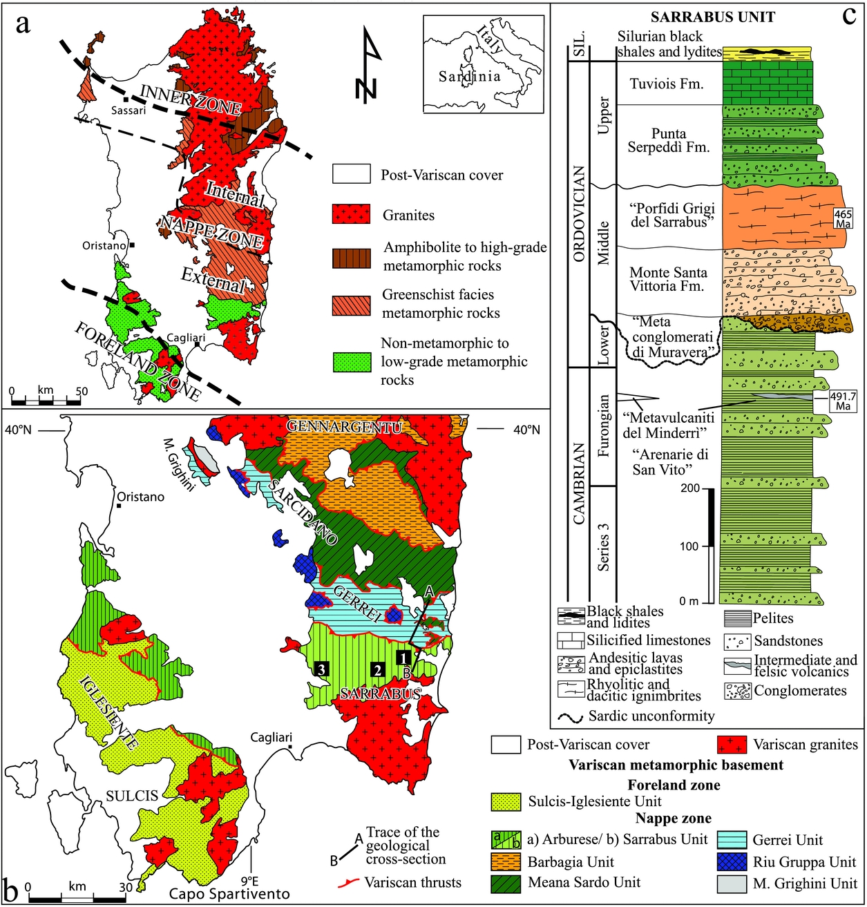
(a) Tectono-metamorphic zones of the Variscan basement of Sardinia. (b) Geological sketch map of the Variscan basement of southern Sardinia. The numbered squares mark the areas studied in this work: 1 – Su Scoffoni; 2 – Riu Ollastu; 3 – Monte Acutzu. (c) Stratigraphic column of the Sarrabus Unit.

In SE Sardinia, although the Sardic Unconformity is well exposed, clear-cut evidence of Early Ordovician deformation has not previously been reported. In this paper, we present new structural data demonstrating that a folding event affected the pre-Middle Ordovician series, but not the younger successions. We conducted structural analysis and detailed (1:5000 scale) geological mapping over three areas located in the shallowest and most external tectonic unit of the Variscan nappe stack (the Sarrabus Unit; Fig. 1b), where the Sardic Unconformity is well exposed. The Sardic Unconformity is difficult to identify in deeper tectonic units (the Gerrei and Meana Sardo units; Fig. 1b), possibly because the later Variscan deformation was pervasive enough to largely mask any Early Ordovician tectonic features. The new data of the present study disclose an Early Ordovician folding event in SE Sardinia. Through a synthesis of our findings with published studies from other areas of the northern Gondwana margin, we propose a framework for correlating Sardic folds, the Sardic Unconformity and associated calc-alkaline volcanism among different regions, and identify the geodynamic setting consistent with the observed relationships.
2. Cambrian–Carboniferous tectono-stratigraphy in southern Sardinia
The main tectonic features of the Palaeozoic Sardinian basement are related to the Variscan Orogeny. The section of the Variscan chain exposed in Sardinia includes three tectono-metamorphic zones (Carmignani et al. Reference Carmignani, Carosi, Di Pisa, Gattiglio, Musumeci, Oggiano and Pertusati1994) (Fig. 1a): a Foreland zone in SW Sardinia; a Nappe zone in southeastern and central Sardinia; and finally an Axial inner zone in northern Sardinia. The Nappe zone is divided into an ‘external Nappe’ in the south, close to the leading edge of the nappe front, and an ‘internal Nappe’ in the north, close to the inner axial zone. The main Variscan shear sense direction in this package is top-to-the-south, changing to top-to-the-west in the final stage of shortening (Conti, Carmignani & Funedda, Reference Conti, Carmignani and Funedda2001). Deformation intensity increases northwards, consistent with the regional metamorphic grade which increases from anchizonal in the south to amphibolite facies in the north.
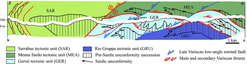
The study area is part of the external Nappe zone that crops out in SE Sardinia and comprises four stacked tectonic units (Fig. 1b). From the deepest to the shallowest, these are the Riu Gruppa Unit, the Gerrei Unit, the Meana Sardo Unit and the Arburese/Sarrabus Unit in the external Nappe zone (Conti, Carmignani & Funedda, Reference Conti, Carmignani and Funedda2001) (Fig. 2). Each tectonic unit is characterized by the same four main lithostratigraphic successions, separated from one another by regional unconformities (Carmignani et al. Reference Carmignani, Conti, Barca, Cerbai, Eltrudis, Funedda, Oggiano, Patta, Ulzega, Orrù and Pintus2001a) as follows: (1) a Lower Cambrian – pre-Middle Ordovician succession shows a transition from intertidal to continental shelf facies deposited along the continental passive margin of northern Gondwana (Cocozza, Reference Cocozza1979; Galassi & Gandin, Reference Galassi and Gandin1992); (2) a Middle Ordovician magmatic and volcano-sedimentary succession of andesitic to fractionated rhyolitic compositions and calc-alkaline affinity, with associated intrusive rocks (Oggiano et al. Reference Oggiano, Gaggero, Funedda, Buzzi and Tiepolo2010; Gaggero et al. Reference Gaggero, Oggiano, Funedda and Buzzi2012); (3) an Upper Ordovician – lower Carboniferous terrigenous to carbonate-dominated succession characterized by Upper Ordovician transgressive siliciclastic deposits (Loi et al. Reference Loi, Barca, Chauvel, Dabard and Leone1992; Loi & Dabard, Reference Loi and Dabard1997), and Silurian–Devonian black shale and limestone (Corradini, Barca & Spalletta, Reference Corradini, Barca and Spalletta2003; Corradini & Ferretti, Reference Corradini and Ferretti2009); and (4) a lower Carboniferous clastic succession interpreted as a Culm-type flysch related to the Variscan orogeny (Barca, Reference Barca1991), which represents the youngest succession affected by Variscan tectonics in Sardinia. The pre-Middle Ordovician succession contains a regional unconformity (the Sarrabese Unconformity) that was first recognized by Calvino (Reference Calvino1959) in the Sarrabus Unit, and was then correlated with the Sardic Unconformity in the 1980s (Barca, Del Rio & Pittau Demelia, Reference Barca, Del Rio and Pittau Demelia1988). The older formations that are not deformed by collisional Variscan tectonics are upper Carboniferous – Permian in age (Cocozza, Reference Cocozza1967) and crop out in scattered intra-continental basins (Pittau, Del Rio & Funedda, Reference Pittau, Del Rio and Funedda2008).
Simplified geological cross-section across the Flumendosa Valley (see the location in Fig. 1b), showing the stacked Variscan tectonic units with the pre-Sardic Unconformity succession highlighted.
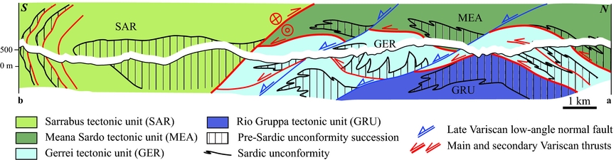
The Foreland zone exposed in SW Sardinia (Fig. 1a) differs litho-stratigraphically from the external Nappe zone in that (1) the Foreland lower Cambrian – pre-Middle Ordovician succession consists of a thick carbonate succession (Pillola, Leone & Loi, Reference Pillola, Leone and Loi1998), whereas equivalent strata in the Nappe zone are mainly siliciclastic; (2) Middle Ordovician volcanic products are absent from the Foreland zone; and (3) the Sardic Unconformity is covered by thick, coarse conglomerates deposited in an alluvial to littoral environment (the Monte Argentu Formation of Leone et al. Reference Leone, Hamman, Laske, Serpagli and Villas1991; Laske, Bechstadt & Boni, Reference Laske, Bechstadt, Boni, Bechstadt and Boni1994) that are largely thicker than those found in SE Sardinia. Moreover, Loi & Dabard (Reference Loi and Dabard1997) describe a difference in sedimentary source of Foreland and external Nappe zone based on zircon typology, and Hamman & Leone (Reference Hamman and Leone1997) suggest that trilobites found in the Foreland are representative of a different bio-province from those collected in the external Nappe zone.
These differences suggest that SW and SE Sardinia were not contiguous during their early Palaeozoic evolution, and were instead part of different zones of northern Gondwana that were juxtaposed during Variscan shortening (Conti, Carmignani & Funedda, Reference Conti, Carmignani and Funedda2001).
3. Cambro-Ordovician succession and tectonics in the Sarrabus Unit of SE Sardinia
The pre-Sardic Unconformity succession in SE Sardinia (in particular in the Sarrabus Unit; Fig. 1c) consists of a thick siliciclastic sequence (the Arenarie di San Vito Formation; Calvino, Reference Calvino1959) of Cambrian – Early Ordovician age (Barca, Del Rio & Pittau Demelia, Reference Barca, Del Rio and Pittau Demelia1988; Gnoli & Pillola, Reference Gnoli and Pillola2002). This sequence is characterized by intercalations of silty-clayey and arenaceous deposits with abundant sedimentary structures (flute casts, load casts, current ripples, etc.), and is interbedded with intermediate and felsic transitional volcanic rocks (the Metavulcaniti del Minderrì lithostratigraphic units) of Furongian age (491.7±3.5 Ma; Oggiano et al. Reference Oggiano, Gaggero, Funedda, Buzzi and Tiepolo2010). The base of the succession is not exposed, whereas its top is defined by an erosional surface (the Sardic Unconformity) that is overlain by a later volcano-sedimentary succession. The apparent thickness of the pre-Sardic Unconformity succession is c. 500 m, but its true original thickness is obscured by the effects of subsequent deformation and erosion, and late Palaeozoic intrusions.
The post-Sardic Unconformity succession (Fig. 1c) starts with the Metaconglomerati di Muravera Formation (Carmignani et al. Reference Carmignani, Conti, Barca, Cerbai, Eltrudis, Funedda, Oggiano, Patta, Ulzega, Orrù and Pintus2001a), which is a clastic deposit containing large (1–10 cm) clasts derived from the underlying siliciclastic metasediments of Arenarie di San Vito Formation, interlayered with sandstone and siltstone. Volcanic clasts are also found locally, probably derived from the Metavulcaniti del Minderrì. The conglomerate crops out discontinuously and varies in thickness from 0 to c. 40 m (Carmignani et al. Reference Carmignani, Conti, Barca, Cerbai, Eltrudis, Funedda, Oggiano, Patta, Ulzega, Orrù and Pintus2001a). The Metaconglomerati di Muravera Formation is overlain by a c. 250 m thick Darriwilian (465±1.4 Ma U–Pb concordia age; Oggiano et al. Reference Oggiano, Gaggero, Funedda, Buzzi and Tiepolo2010) calc-alkaline volcanic succession (Fig. 1c) that consists of basal andesitic lavas and epiclastites (the Monte Santa Vittoria Formation; Carmignani et al. Reference Carmignani, Conti, Barca, Cerbai, Eltrudis, Funedda, Oggiano, Patta, Ulzega, Orrù and Pintus2001a) overlain by rhyolitic and dacitic ignimbrites (Porfidi Grigi del Sarrabus Formation; Calvino, Reference Calvino1959). A pronounced angular unconformity (discordance of up to 90°) separates the pre-Sardic Arenarie di San Vito Formation from the post-Sardic volcano-sedimentary succession (Carmignani et al. Reference Carmignani, Conti, Barca, Cerbai, Eltrudis, Funedda, Oggiano, Patta, Ulzega, Orrù and Pintus2001a, Reference Carmignani, Oggiano, Barca, Conti, Salvadori, Eltrudis, Funedda and Pascib; Cocco & Funedda, Reference Cocco and Funedda2011, Reference Cocco and Funedda2012). The Sardic deformation in SE Sardinia occurred during Early–Middle Ordovician time. The youngest sediments deformed by the Sardic tectonic event contain Arenig fossils (SE Sardinia: Gnoli & Pillola, Reference Gnoli and Pillola2002; SW Sardinia: Pillola, Piras & Serpagli, Reference Pillola, Piras and Serpagli2008), while the oldest formations of known age unaffected by the Sardic event are the Middle Ordovician volcanites belonging to the Monte Santa Vittoria and Porfidi grigi del Sarrabus formations (Oggiano et al. Reference Oggiano, Gaggero, Funedda, Buzzi and Tiepolo2010; Gaggero et al. Reference Gaggero, Oggiano, Funedda and Buzzi2012; Pavanetto et al. Reference Pavanetto, Funedda, Northrup, Schmitz, Crowley and Loi2012).
The Middle Ordovician volcano-sedimentary succession is unconformably overlain by sandstone, conglomerate and siltstone in the lower beds of the Upper Ordovician succession, which then gives way to alternating marls and silicified limestone (Fig. 1c), attesting to its marine transgression (Loi et al. Reference Loi, Barca, Chauvel, Dabard and Leone1992; Pistis, Loi & Dabard, Reference Pistis, Loi and Dabard2016) (Fig. 1c). The overlying Silurian succession consists of black shale with interbedded limestone lenses (Barca & Jäger, Reference Barca and Jäger1989).
The entire stratigraphic succession of the Sarrabus Unit is affected by two principal Variscan deformational phases (Carmignani et al. Reference Carmignani, Carosi, Di Pisa, Gattiglio, Musumeci, Oggiano and Pertusati1994; Conti, Carmignani & Funedda, Reference Conti, Carmignani and Funedda2001): (1) a compressive event of Visean–Namurian age (Carmignani et al. Reference Carmignani, Conti, Barca, Cerbai, Eltrudis, Funedda, Oggiano, Patta, Ulzega, Orrù and Pintus2001a) that produced west-verging, nearly isoclinal folds, pervasive axial planar cleavage and thrusts that were in turn refolded by hectometric- to kilometric-scale large antiforms and synforms (Conti & Patta, Reference Conti and Patta1998); and (2) a late-orogenic extensional event that probably occurred before late Westfalian time and is marked by low-angle normal shear zones, transcurrent faults and high-angle normal faults (Conti et al. Reference Conti, Carmignani, Oggiano, Funedda and Eltrudis1999).
4. Sardic deformation in the Sarrabus Unit
Evidence of the Sardic deformation in SE Sardinia is largely obscured due to overprinting by polyphase Variscan deformation. We undertook detailed mapping of the Sarrabus Unit in three key areas (Fig. 1) where the Sardic Unconformity is well exposed: Su Scoffoni, Riu Ollastu and Monte Acutzu (Fig. 1b). Pre-Variscan structures can also be recognized in the three examined areas by comparing the structural characteristics of the pre- and post-Sardic Unconformity successions, including younging directions, the orientations of bedding and fold axes, the occurrence of axial planar cleavage and structural facing directions. Reconstructing folds at the map-scale for this sequence is challenging because of the scarcity of continuous marker beds in the pre-Sardic Unconformity succession (restricted largely to the Arenarie di San Vito Formation), which hinders assessments of fold shape, style and attitude.
4.a. Su Scoffoni
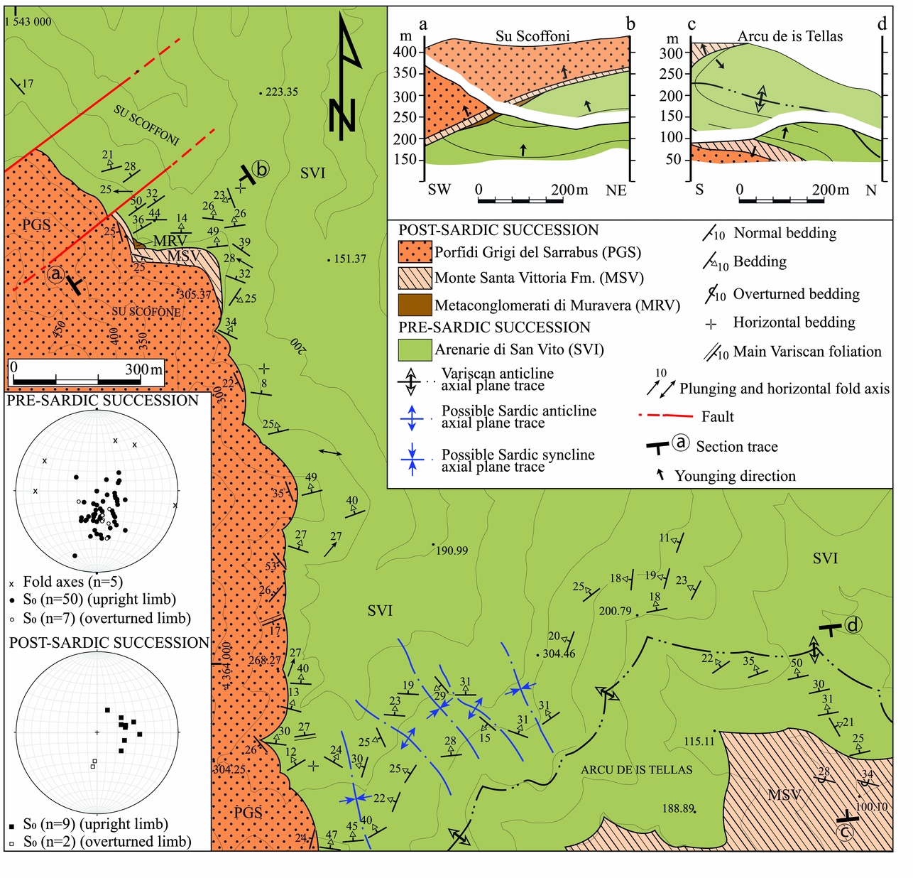
In the Su Scoffoni area (Fig. 3), the Arenarie di San Vito Formation consists of layered sandstone and siltstone characterized by both parallel and cross-bedded sedimentary structures. A small body of Metaconglomerati di Muravera Formation is overlain by the andesitic lavas and epiclastites of Monte Santa Vittoria Formation and the ignimbrites of Porfidi Grigi del Sarrabus Formation.
Geological map of the Middle Ordovician angular unconformity in the Su Scoffoni area. Equal-area, lower-hemisphere stereoplots of fold axes and bedding planes from the Arenarie di San Vito area, and bedding planes from the post-Sardic Unconformity succession in the Su Scoffoni area. Cross-section showing the geometric relationships between the pre-Sardic and post-Sardic Unconformity successions.

The main tectonic structure that affects the whole Palaeozoic succession of this area, including the Sardic Unconformity, is a Variscan recumbent antiform with a NW-dipping axial plane (Fig. 3). The normal limb crops out in the western sector of the area, while the overturned limb crops out close to Arcu de is Tellas (see the SE sector of the map and geological cross-section c–d in Fig. 3). In the normal limb, the angular discordance of bedding across the Sardic Unconformity is consistently close to 90° (see geological cross-section a–b in Fig. 3). In the overturned limb, despite the Variscan overturning (geological section c–d in Fig. 3), the strata in the Arenarie di San Vito Formation (geological section c–d in Fig. 3) have a normal polarity, as suggested by the cross-stratification. Evidently, this overturning has affected a sequence which was previously reversed but was straightened during the Variscan Orogeny.
In the central–southern sector of Su Scoffoni area, NNW–SSE-striking folds could also be ascribed to the Sardic Phase. They are antiforms and synforms with a wavelength of roughly 200–300 m, subvertical axial planes and NNW-dipping fold axes that seem to be truncated by the Sardic Unconformity. Comparable folds have not been found in the post-Sardic Unconformity succession.
The complex geometry of the pre-Sardic Unconformity succession compared with the post-Sardic succession is further demonstrated by the attitude of bedding (S0), which is more scattered in the Arenarie di San Vito Formation than in the post-Sardic Unconformity succession (Fig. 3).
Although it is not possible to clearly distinguish the superposition of folds in the field in this area, this combination of structural evidence therefore demonstrates that the pre-Sardic Unconformity series experienced a folding event that pre-dates the Sardic Unconformity.
4.b. Riu Ollastu
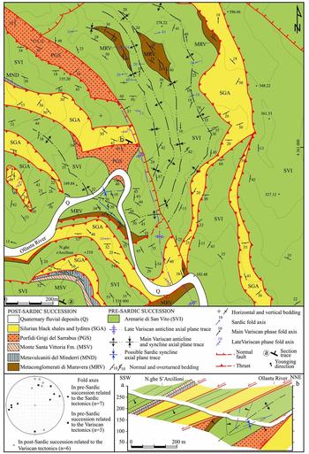
The Riu Ollastu area is characterized by a more complex structural setting than the other mapped areas, related principally to polyphase Variscan deformation affecting the Cambrian–Silurian succession (Fig. 4). The first Variscan phase is characterized by isoclinal W-facing folds with an axial planar foliation and N-trending fold axes, and by numerous imbricate thrust sheets along the W-verging thrust that separates the Sarrabus and Gerrei units (Carmignani et al. Reference Carmignani, Conti, Barca, Cerbai, Eltrudis, Funedda, Oggiano, Patta, Ulzega, Orrù and Pintus2001a; Conti, Carmignani & Funedda, Reference Conti, Carmignani and Funedda2001). These tectonic structures were themselves deformed into a large antiform during a late Variscan folding event (Conti & Patta, Reference Conti and Patta1998).
Geological map of the Riu Ollastu area. Cross-section showing the geometric relationships between the pre-Sardic and post-Sardic Unconformity successions. Equal-area, lower-hemisphere stereoplots of fold axes from the post-Sardic Unconformity succession and from the Arenarie di San Vito Formation in the Riu Ollastu area.

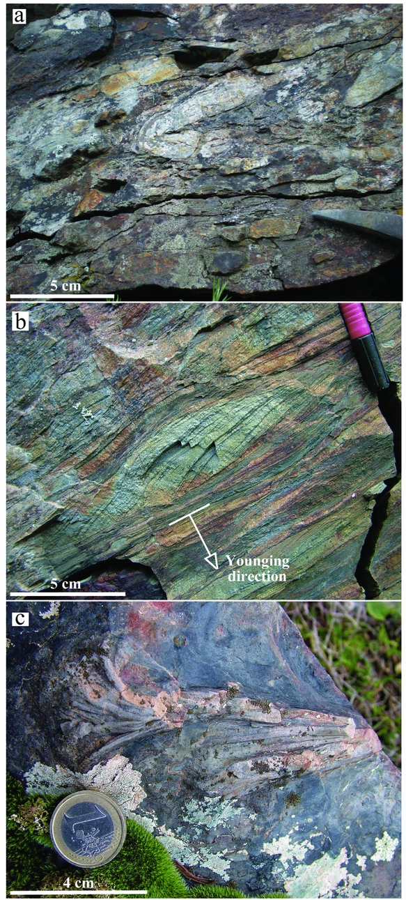
In the clastic rocks of Arenarie di San Vito Formation immediately below the Sardic Unconformity, the younging direction indicated by flute-casts, cross-lamination (Fig. 5b) and numerous specimens of Phycodes circinatum (Fig. 5a) highlights how the succession is overturned (Fig. 5c); the post-Sardic succession (here the Metaconglomerati di Muravera Formation) therefore lies directly above overturned strata of the pre-Sardic Unconformity succession. Furthermore, close to a meander of the Ollastu River, both way-up and overturned strata of the Arenarie di San Vito Formation (defining a Sardic syncline) are capped by the ignimbritic flows of Porfidi Grigi del Sarrabus Formation. This fold has been refolded twice during Variscan tectonism, producing an antiformal syncline (see the geological cross-section a–b in Fig. 4).
(a) The Metaconglomerato di Muravera Formation above the Sardic Unconformity. (b) Centimetre-scale cross-laminated sandstone in the Arenarie di San Vito Formation, with sharp erosive contact that indicates an overturned younging direction. (c) Phycodes circinatum on an overturned limb of the Arenarie di San Vito Formation that lies directly below the same unconformity. All the outcrops are located in the Riu Ollastu area.

In the pre-Sardic Unconformity succession, the wide range of fold axis orientations (Fig. 4) suggests that it was the product of subsequent fold events. To isolate these episodes from the overprinting effect of the late Variscan folding, the deformation has been studied in homogeneous domains on the eastern limb of the late Variscan antiform (Fig. 4). Under these conditions it is possible to recognize both E- and N-trending folds. The E-trending folds involve only the pre-Sardic succession and, in the few outcrops where it is possible to observe them directly, these structures generally have a decimetre-scale wavelength, are close in form with sub-rounded and thickened hinges, moderately inclined and plunging, with a SSW-dipping axial plane but lacking an axial planar foliation. The N-trending folding affects both pre- and post-Sardic formations, particularly well exposed in the Silurian shales. These folds are associated with an axial planar foliation and, at the outcrop scale, vary from close to tight, with subangular/sub-rounded hinges and an equant aspect ratio (ratio of the amplitude to the distance between adjacent inflection points, after Twiss, Reference Twiss1988). These data suggest that the pre-Sardic succession was folded then eroded by the event that produced the Sardic Unconformity, and folded again during the Variscan event.
4.c. Monte Acutzu
The Sardic Unconformity is well exposed in the Monte Acutzu area (Fig. 6). Here, the Arenarie di San Vito Formation consists of alternating layers of arenaceous and silty-clayey deposits, and is discordantly overlain by the Metaconglomerati di Muravera Formation and by the volcanites of the Monte Santa Vittoria and Porfidi Grigi del Sarrabus formations. In this area the angular discordance of beds across the unconformity reaches 90°, and locally overturned strata of the Arenarie di San Vito Formation lie directly below the post-Sardic succession.
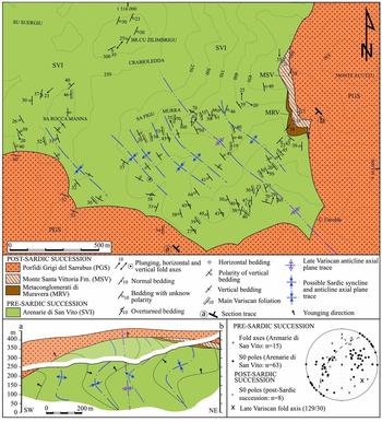
Geological map of the Monte Acutzu area. Equal-area, lower-hemisphere stereoplot of fold axes and bedding planes from the Arenarie di San Vito Formation and bedding planes from the post-Sardic Unconformity succession in the Monte Acutzu area. Cross-section showing the geometric relationships between the pre-Sardic and post-Sardic Unconformity successions.

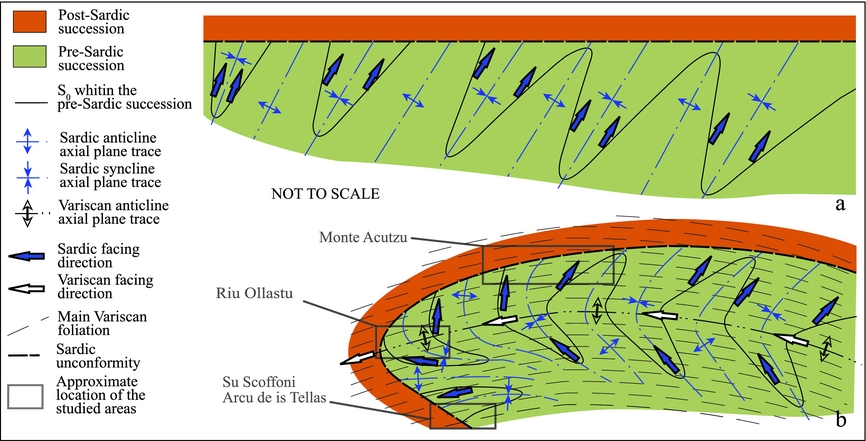
The entire succession is deformed by a late Variscan open fold with a SE-plunging fold axis (Fig. 6) that refolds a subhorizontal axial planar foliation related to the earlier Variscan phase (Carmignani et al. Reference Carmignani, Conti, Barca, Cerbai, Eltrudis, Funedda, Oggiano, Patta, Ulzega, Orrù and Pintus2001a). The S0 foliation in the Arenarie di San Vito Formation is more variable in orientation than in the post-Sardic succession, and the fold axes are also highly scattered and range from horizontal to vertically plunging (Fig. 6). In the Arenarie di San Vito Formation the subhorizontal Variscan foliation cuts both limbs of decametric-scale, upright, close folds at a consistent angle, meaning the folds can be ascribed to the Sardic Phase. This is particularly clear to the south of Sa Rocca Manna, in the western part of the Monte Acutzu area (Fig. 6). Finally, the folded Arenarie di San Vito Formation shows opposite structural facing directions (Shackleton, Reference Shackleton1957), whereas in the post-Sardic succession the facing is constantly westwards, consistent with the kinematics of Variscan tectonics (Fig. 7).
Simplified scheme to explain the different facing directions in the Arenarie di San Vito Formation. (a) Geological setting in Middle–Upper Ordovician stratigraphy. (b) Geological setting after the development of the main Variscan foliation and the following gentle folding event.

5. Discussion
The structural data collected from the three areas studied here suggest that in the external Nappe zone exposed in SE Sardinia, the upper Cambrian – Lower Ordovician sedimentary succession (pre-Sardic succession) underlying the Sardic Unconformity was affected by a folding event that was not experienced by the overlying post-unconformity succession. Although Sardic folds are difficult to recognize in the field due to overprinting by Variscan deformation, and can only rarely be reconstructed at the map scale, Sardic folding is supported by a number of indirect structural observations, as follows. (1) Large sections of overturned pre-Middle Ordovician strata are capped by the Sardic Unconformity and affected by Variscan deformation. By restoring the Variscan deformation, unfolding the Variscan folds, the downwards-younging direction in the Arenarie di San Vito Formation (see the geological cross-section c–d in Fig. 3 across the Arcu de is Tellas area) indicates the occurrence of pre-Variscan overturned folds. (2) Removing the Variscan deformation also demonstrates the occurrence of variably oriented axial planes and fold axes within the pre-Sardic succession, indicating a folding event not detected in the post-Sardic succession. (3) The pre-Sardic succession contains folds that lack the axial planar foliation typical of Variscan deformation. (4) The Variscan foliation clearly post-dates the Sardic folds. (5) The opposite structural facing directions in the pre-Sardic succession corroborate the occurrence of a folding event not found in the post-Sardic succession.
The lack of a syn-folding foliation in the pre-Sardic succession suggests that the Sardic deformation probably occurred at a shallow structural level where the temperature and pressure were not high enough to allow cleavage development in siliciclastic rocks. The size of overturned limbs and the lack of evidence of faulting (e.g. fault rocks, stratigraphic separation) in the pre-Middle Ordovician succession rules out the possibility that these folds are drag structures that formed along Sardic faults. Furthermore, no older crust is involved in the Sardic folds, thereby indicating the thin-skinned nature of the deformation.
5.a. Geodynamic setting of the Sardic Phase
By combining the data presented above with the results of previous studies of Variscan terranes, we seek to reconstruct the geodynamic evolution of SE Sardinia along the northern Gondwana margin during early Palaeozoic time (Fig. 8).
Late Cambrian (a) plate-tectonic and (b) northern Gondwana margin reconstructions (modified after von Raumer et al. Reference von Raumer, Stampfli, Arenas and Sànchez Martìnez2015). (c) Late Floian plate-tectonic reconstruction (modified after Stampfli et al. Reference Stampfli, Hochard, Vérard, Wilhem and von Raumer2013). Note that the opening of the Rhéic Ocean had not yet affected the eastern side of Northern Gondwana. Av – Avalonia; Ba – Baltica; NC – North China; Qa – Qaidam Ocean; Qi – Qilian; SC – South China.

5.a.1. Andean-type geodynamic model for the Sardic Phase
Based on the petrography, geochemistry and geochronology of the Middle Ordovician volcanic rocks of Sardinia, Oggiano et al. (Reference Oggiano, Gaggero, Funedda, Buzzi and Tiepolo2010) and Gaggero et al. (Reference Gaggero, Oggiano, Funedda and Buzzi2012) suggested that the geodynamic setting of the Sardic Phase was an Andean-type arc that initiated during subduction of the Rhéic Ocean lithosphere under the continental terranes of northern Gondwana that eventually developed also a back-arc basin (see fig. 11 in Gaggero et al. Reference Gaggero, Oggiano, Funedda and Buzzi2012). This interpretation is consistent with the earlier hypothesis of Carmignani et al. (Reference Carmignani, Carosi, Di Pisa, Gattiglio, Musumeci, Oggiano and Pertusati1994). The same authors (Oggiano et al. Reference Oggiano, Gaggero, Funedda, Buzzi and Tiepolo2010) interpreted the 491.7±3.5 to 479±2.1 Ma volcanic rocks interbedded with the Cambro-Ordovician sediments as a volcanic stage preceding the calc-alkaline, subduction-related Middle Ordovician volcanic suite. According to this model, the absence of Middle Ordovician volcanites in SW Sardinia indicates that this area was a back-arc region (Carmignani et al. Reference Carmignani, Carosi, Di Pisa, Gattiglio, Musumeci, Oggiano and Pertusati1994), whereas SE Sardinia was the arc region. These papers can be merited with recognizing and strengthening the occurrence of an Early Ordovician oceanic subduction under continental crust; additional considerations can now be made to better describe the geodynamic setting in which that plate convergence developed.
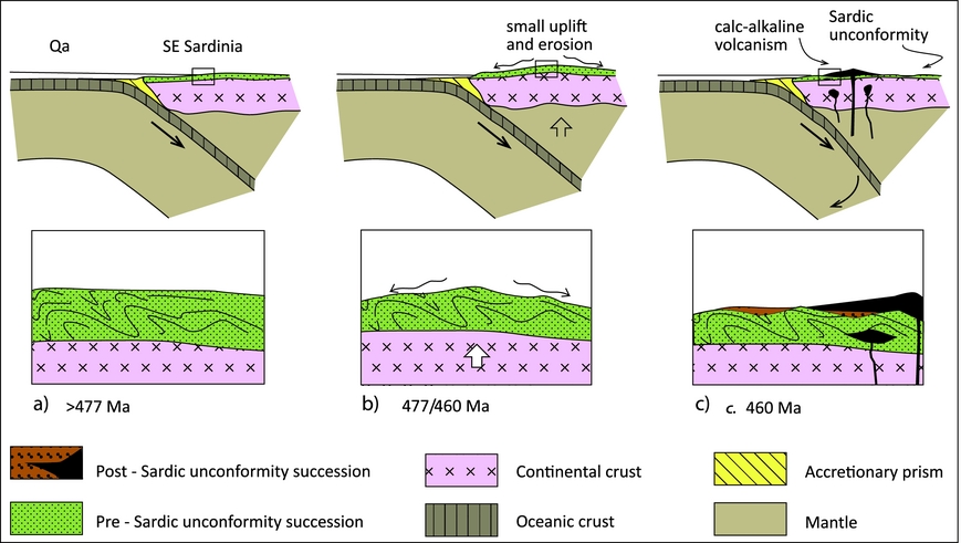
The following observations derived from geological mapping in SE Sardinia can be integrated with published studies to define a more complete framework for the Sardic tectonic event. (1) In SE Sardinia, tight and overturned folds affecting just the Early Ordovician rocks can be found (Fig. 9a). (2) The Sardic Unconformity indicates an erosional episode between Floian and Darriwilian times (477–465 Ma), probably in response to uplift of the Lower Ordovician succession in the convergent setting (Fig. 9b). Thereafter, the erosional surface and the compressive structures below it were overlain in SW Sardinia by alluvial to littoral conglomerates (the Monte Argentu Formation) produced during the period of broad uplift of the region (Martini et al. Reference Martini, Tongiorgi, Oggiano and Cocozza1991). In SE Sardinia, the equivalent unconformity is overlain by a Middle Ordovician volcano-sedimentary succession (Fig. 9c). The occurrence of marginal marine–littoral sedimentation on the Sardic unconformity suggests that the uplift, which was not strong enough to produce a highland morphology, occurred before the emplacement of the Middle Ordovician succession.
Simplified cartoon of the main features of the Sardic tectonic evolution: (a) convergence between Qaidam ocean (Qa) and the northeastern Gondwana margin and deformation of the pre-Sardic unconformity succession; (b) small uplift of the upper plate related to the subduction and subsequent developing of the Sardic unconformity; and (c) emplacement of the calc-alkaline volcanism and ending of the convergence.

According to these observations, the Sardic folding, angular unconformity and arc-type volcanism could be the deformational, morphological and magmatic components of a subduction system that did not reach the terminal stage of continental collision (see Carmignani et al. Reference Carmignani, Carosi, Di Pisa, Gattiglio, Musumeci, Oggiano and Pertusati1994 for a discussion of the main evidence that a continental collision was not reached).
Some of the features summarized above (Fig. 9) are not entirely consistent with the Andean-type geodynamic system proposed by Carmignani et al. (Reference Carmignani, Carosi, Di Pisa, Gattiglio, Musumeci, Oggiano and Pertusati1994), Oggiano et al. (Reference Oggiano, Gaggero, Funedda, Buzzi and Tiepolo2010) and Gaggero et al. (Reference Gaggero, Oggiano, Funedda and Buzzi2012). These features include the following. (1) In the Andean model deformation extends to deep structural levels, affecting both the sedimentary cover and the older cratonic crust, whereas the compressive Sardic structures were developed entirely at shallow structural levels. (2) The Andean volcanic arc rests on crystalline basement, whereas the Sardinian Middle Ordovician volcanic arc rests on folded Sardic sediments. (3) In the Andean model the upper plate is affected by strong uplift, with deposition of coarse sediments in highland areas (e.g. the Atacama Desert in the South Andean plateau), whereas in Sardinia the deposits resting on the Sardic Unconformity were all laid down near sea level, suggesting that only minor uplift occurred during the Sardic Phase. (4) Exhumation of the lower crust, a defining feature of the Andean model, is not observed in Sardinia.
Further, the proposed model does not take into account the timing of the Rhéic opening that, according to recent studies (von Raumer & Stampfli, Reference von Raumer and Stampfli2008; Nance et al. Reference Nance, Gutierrez-Alonso, Keppie, Linnemann, Murphy, Quesada, Strachan and Woodcock2010), began in late Cambrian time in the western part of the north Gondwana margin (Fig. 8a, b) and only later in the eastern part (Fig. 8c), where current reconstructions (Stampfli et al., Reference Stampfli, Hochard, Vérard, Wilhem and von Raumer2013; von Raumer et al. Reference von Raumer, Stampfli, Arenas and Sànchez Martìnez2015) place the Palaeozoic Sardinia.
5.a.2. Alternative geodynamic models for the Sardic Phase
The data currently available prevent the development of a robust integrated geodynamic model of the northern Gondwana margin during early Palaeozoic time. We emphasize that some of the above-listed characteristics, such as the absence of large thrust sheets, the lack of lower crustal involvement in deformation and the lack of strong uplift, could be consistent with other models incorporating more complex tectonic geometries, such as oblique plate convergence and the occurrence of a sedimentary subduction channel preventing strong uplift and deformation of the overriding plate (De Franco, Govers & Wortel, Reference De Franco, Govers and Wortel2007; Malatesta et al. Reference Malatesta, Gerya, Crispini, Federico and Capponi2016). The occurrence of slab retreat during convergence (e.g. Japanese-like subduction) should be taken into account, because it does not develop a strong uplift. However, one of the main differences from the SE Sardinia Early Ordovician geodynamic setting is that the volcanic arc related to the oceanic subduction under the Japanese margin lies on exhumed high metamorphic rocks that were part of ancient accretionary prisms (Taira, Reference Taira2001). Conversely, in Sardinia the volcanic arc rests on the folded Sardic succession. Some characteristics could be consistent with the subduction–accretion orogenic model (Crook, Reference Crook1980; Collins, Reference Collins2002) recently proposed by Zurbriggen (Reference Zurbriggen2015, Reference Zurbriggen2017) for the early Palaeozoic basement of the western Alps, where Middle Ordovician magmatic products are similar in age and geochemical affinity to those (intrusive and effusive) in Sardinia (Oggiano et al. Reference Oggiano, Gaggero, Funedda, Buzzi and Tiepolo2010; Pavanetto et al. Reference Pavanetto, Funedda, Northrup, Schmitz, Crowley and Loi2012). The same model has also been proposed for the Lachlan Fold Belt (Foster & Grey, Reference Foster and Grey2000; Collins, Reference Collins2002; Glen, Reference Glen, Vaughan, Leat and Pankhurst2005) of the eastern Gondwana margin. Subduction–accretion differs from Andean-type subduction in that new continental crust is laterally accreted onto the craton margin, rather than being emplaced on top of it (Zurbriggen, Reference Zurbriggen2017). Consequently, thrust sheets and nappe zones are largely absent from such a margin, as is substantial thickening of continental crust and related metamorphism and deformation. Despite these favourable elements, the subduction–accretion model is inconsistent with the absence of evidence of Ordovician accreted continental crust with steepened tectonic structures and the lack of an Ordovician trench in present-day Sardinia; this model therefore does not provide a comprehensive explanation of the available data.
5.b. The Sardic Phase in the widespread north Gondwana terranes
The stratigraphic and structural features described for southern Sardinia can be correlated across other areas of the northern Gondwana margin. In the eastern Pyrenees, the Cambro-Ordovician successions of some Alpine units can be correlated with those of Sardinia. An upper Neoproterozoic – Lower Ordovician siliciclastic succession (Cavet, Reference Cavet1957; Castiñeiras et al. Reference Castiñeiras, Navidad, Liesa, Carreras and Casas2008; Casas & Palacios, Reference Casas and Palacios2012) is unconformably overlain by an Upper Ordovician succession characterized by the basal Rabassa conglomerate (Hartevelt, Reference Hartevelt1970; Laumonier, Reference Laumonier, Canérot, Colin, Platel and Bilotte2008) and locally by Upper Ordovician metavolcanic rocks of the Ribes de Freser Unit. In the La Molina area (eastern Pyrenees), Casas (Reference Casas2010) mapped Middle Ordovician folds without an axial planar cleavage that occur beneath an angular unconformity. As in the Sarrabus Unit, these folds are cut by the main Variscan cleavage and are unconformably overlain by the Middle–Upper? Ordovician succession. In Portugal, the Mação-Vale do Grou area in the Centro-Iberian zone is characterized by folds without an axial planar cleavage in sedimentary sequences of Cambrian – Early Ordovician age ascribed to the Sardic Phase. In this case, the structures are also overlain by an Ordovician volcano-sedimentary succession and refolded by Variscan structures (Romão et al. Reference Romão, Coke, Dias and Ribeiro2005).
The timing of the Sardic deformation in SE Sardinia is consistent with that in SW Sardinia and that inferred for deformation events in some areas of northern Gondwana (Romão et al. Reference Romão, Coke, Dias and Ribeiro2005; Castiñeiras et al. Reference Castiñeiras, Navidad, Liesa, Carreras and Casas2008; Casas et al. Reference Casas, Castiñeiras, Navidad, Liesa and Carreras2010, Reference Casas, Queralt, Mncos and Gratacòs2012; Del Greco, Johnston & Shaw, Reference Del Greco, Johnston and Shaw2016), demonstrating continuity in the tectonic conditions affecting terranes along the continental margin, although the exact nature of these conditions is relatively unknown.
It follows from these arguments that field, structural and geochemical data from now-scattered Variscan terranes that were part of early Palaeozoic northern Gondwana corroborate the idea that blocks along its margin were affected by convergent tectonics during Ordovician time. However, many palaeo-tectonic reconstructions propose a generalized rift setting for the region at this time related to the progressive opening of the Rhéic Ocean and closure of the Iapetus Ocean (von Raumer et al. Reference von Raumer, Bussy, Schaltegger, Schulz and Stampfli2013; Alvaro et al. Reference Alvaro, Colmenar, Monceret, Pouclet and Vizcaino2016; Domeier, Reference Domeier2016). Nance et al. (Reference Nance, Gutierrez-Alonso, Keppie, Linnemann, Murphy, Quesada, Strachan and Woodcock2010), Stampfli et al. (Reference Stampfli, Hochard, Vérard, Wilhem and von Raumer2013) and von Raumer et al. (Reference von Raumer, Stampfli, Arenas and Sànchez Martìnez2015) propose that the opening of the Rhéic Ocean started during late Cambrian time and proceeded from west to east. During Early Ordovician time, these reconstructions place Sardinia on the eastern side of the northern margin of Gondwana. It was still a convergent setting (Li et al. Reference Li, Pei, Li, Pei, Liu, Chen, Zhang, Wang and Xu2016) where the Qaidam Ocean (more or less coincident with the Proto Tethys Ocean according to previous reconstructions, e.g. von Raumer & Stampfli, Reference von Raumer and Stampfli2008) was subducting under the South China terrane with SE Sardinia being located close to the convergent margin of the upper plate and, on the basis of our findings, probably somewhat closer to the margin than previously thought (von Raumer & Stampfli, Reference von Raumer and Stampfli2008; von Raumer et al. Reference von Raumer, Bussy, Schaltegger, Schulz and Stampfli2013). Furthermore, the lack of the calc-alkaline volcanism in SW Sardinia and the strong differences in the pre-Sardic sedimentary successions between SE and SW Sardinia conflict with the published reconstruction that considers the present-day Sardinia as a unique crustal block since Cambrian time (as still reported in Fig. 8). This tectonic system ended with the Late Ordovician amalgamation of the Hunia and Qilian terranes, with a switch to the passive margin conditions of the eastern Rhéic Ocean. Contrary to what was previously believed, the theory that SW and SE Sardinia were separated during early Palaeozoic time and only amalgamated during the Variscan Orogeny cannot be ruled out.
6. Conclusions
Detailed geological mapping, field observations and structural analysis of the Variscan Sarrabus Unit in SE Sardinia indicate that a folding event (the Sardic event) affected the pre-Middle Ordovician series of this region. These folds represent an early stage of tectonic convergence, followed by minor uplift of the upper plate and later by calc-alkaline arc-type Middle Ordovician volcanites still related to the subduction and emplaced above the folded succession. Considering the inferable tectonic features of the Sardic Phase in SE Sardinia (deformation style, structural level, lack of exhumation of lower crust, small uplift) we suggest that the Sardic compression event did not necessarily develop in an Andean-like orogenic context, as commonly accepted in previous studies.
The pre-Variscan deformation event identified in SE Sardinia can be correlated with the ‘Sardic compressive phase’ described in other parts of the now-scattered South Variscan realm (e.g. the Pyrenees and Portugal). This suggests that the terranes along the northern Gondwana margin did not act as a passive margin from the early Cambrian period until their inclusion in the Variscan Orogeny, because convergent tectonics instead occurred in northeast Gondwana during the Early Ordovician period, contemporaneous with the opening of the Rhéic Ocean in the west and closure of the Qaidam Ocean in the east that was still subducting under the Gondwana margin. The field data presented here come from one of the few areas where early Palaeozoic structural features are still recognizable; we believe that these data could be useful in reconstructing the plate-tectonic configuration and the geodynamic setting of the northern Gondwana margin before the Variscan Orogeny.
Acknowledgements
This work has been partially carried out in the framework of the new geological mapping of Italy funded by the Italian Geological Survey (now ISPRA), Regione Autonoma della Sardegna (L. 222/99, grant to A.F.) and by the Italian government (MIUR-PRIN2007, grant to A.F.). We are grateful to Francesco Leone for discussions and helpful suggestions and to Paola Cara and Pierandrea Marras for their field support. We thank M. Zucali and D. Zanoni for their helpful observations on an earlier version of this paper. We are also grateful to two anonymous reviewers for their constructive comments and suggestions, and to the editor O. Lacombe.