Commerce, economies, population, and settlements were dynamic phenomena during the Classic period in Mesoamerica, particularly in those areas involved in economic production, intense trading, and the transport of goods from places like the Gulf Coast of Veracruz and the coastal fringes of the peninsula of Yucatan to the east (Andrews Reference Andrews, Clancy and Harrison1990; Andrews and Mock Reference Andrews, Mock, Masson and Freidel2002; Rattray Reference Rattray and Rattray1998). During this epoch, coastal communities usually engaged both in the production and the trade of various raw materials and crafted goods. Before the rise of merchant confederations—which increasingly controlled the peninsular trade networks after a.d. 700—most of these coastal trade and production sites retained relative autonomy, with many rising to relative prosperity by combining basic subsistence economy with resource exploitation and exchange activities.
Scholarship on coastal Mesoamerican trade networks has traditionally focused on the sourcing of nonlocal natural resources and the distribution of goods with known proveniences, like different ceramic wares and figurines. At present, these combined archaeological and geological approaches have successfully mapped the sources, production areas, and transportation routes for much of Mesoamerica; at least for those goods that are evidenced in the material record (Ball Reference Ball, Eaton and Ball1978; Hirth Reference Hirth1984; Lee and Navarrete Reference Lee and Navarrete1978; McKillop Reference McKillop2002; Pastrana Reference Pastrana2002). More problematical and limited is the understanding of the actual social, political, economic, and human dynamics behind Mesoamerican production and exchange, as these are not directly apparent from the material record.
The limitations in inferring embedded social dynamics from the archaeological record has been a point of departure for a series of studies of which this one seeks a deeper understanding of the foundations of ancient Mesoamerican production and trade networks beyond the recognition of shifting distribution patterns in the material record. This quest necessarily includes the ancient human actors who participated actively in the production process, exchange, administration, supervision, and control. By combining analyses of the material culture with that of human skeletal remains, we hope to gain an integrated knowledge about trade dynamics and the traders themselves, including their lifestyle, ethnicity, and their geographic mobility.
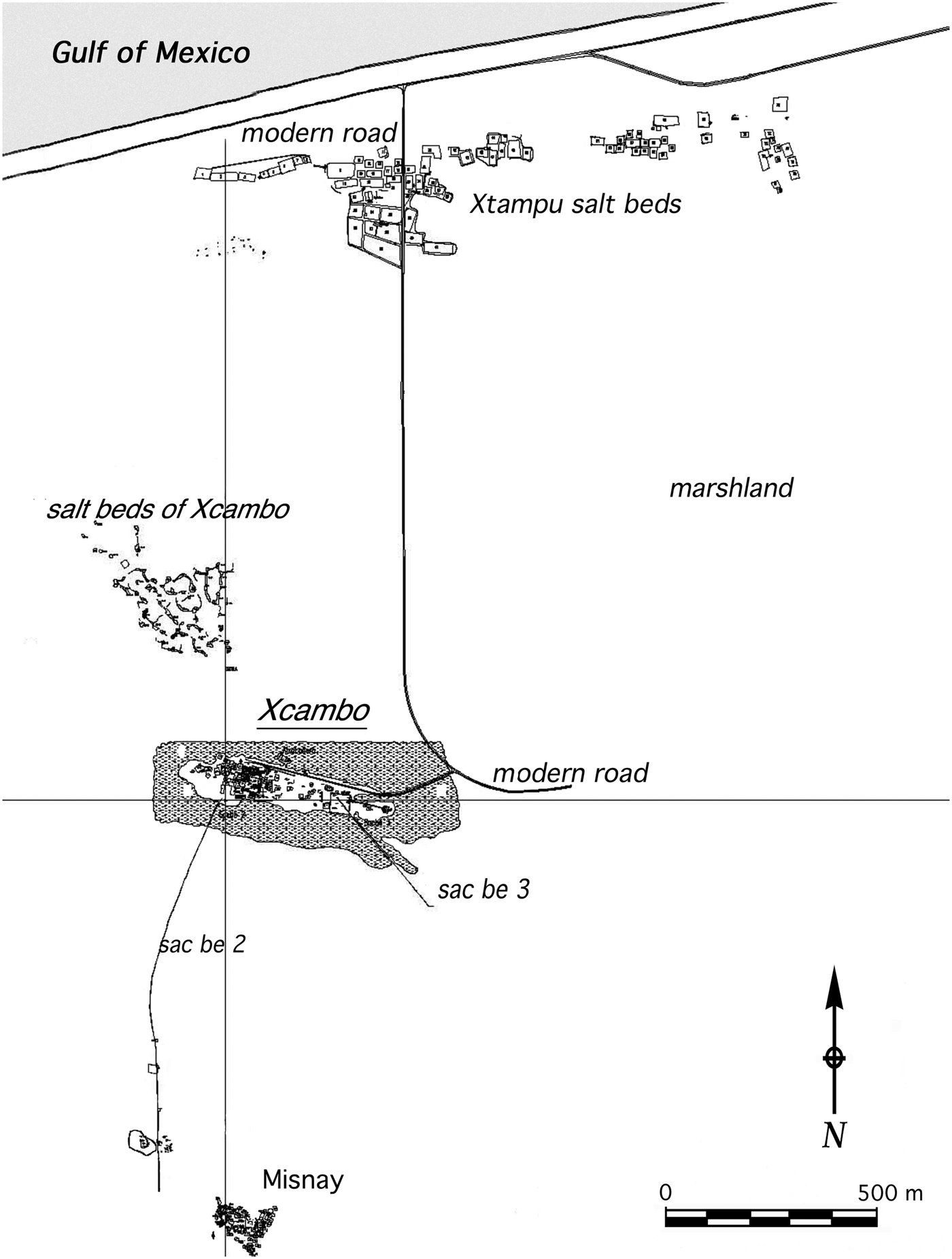
We have pursued a single-site perspective for this approach by selecting the Classic period coastal port of Xcambo on Yucatan's north coast (Figure 1). This is an extensively studied settlement, which allowed us to combine fruitfully different data sets to conduct a sort of “living site anatomy.” Its local folks and their neighbors were involved in intense trading and transportation, and the data sets highlight the gradual, increasingly visible changes that took place in the peninsular political and economic landscape in the second half of the first millennium a.d., which culminated in the rise of a powerful new merchant network under the auspices of the cult of Quetzalcoatl and controlled by the city of Chichen Itza (Andrews et al. Reference Andrews, Andrews and Robles2003; Cobos Reference Cobos, Demarest, Rice and Rice2005; Kowalski and Kristan-Graham Reference Kowalski and Kristan-Graham2007; Ringle et al. Reference Ringle, Gallareta and Bey1998). These changes constitute one of the enduring puzzles in Mesoamerican archaeology.
Area map of coast line, salt beds, archaeological sites, and roads around the elevated marshland island of Xcambo.

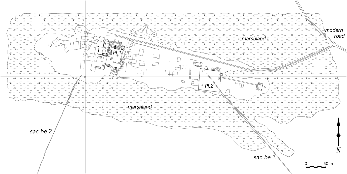
Xcambo was set strategically on top of a small artificial platform surrounded by natural marshlands (Figure 2). The site has been described as a salt production center and port (Sierra Sosa Reference Sierra Sosa2004). Explored intensively by the senior author of this paper, the settlement has been the object and focus of various interdisciplinary efforts (Ceballos Reference Ceballos2003; Cetina and Sierra Reference Cetina and Sierra2005; Cucina Reference Cucina2011; Cucina et al. Reference Cucina, Tiesler, Sierra and Neff2011a, Reference Cucina, Perera, Sierra and Tiesler2011b; Götz and Sierra Reference Götz and Sierra2012; Jiménez Reference Jiménez2002; Maggiano et al. Reference Maggiano, Schultz, Kierdof, Sierra, Maggiano and Tiesler2008; Méndez et al. Reference Méndez, Sierra, Tiesler and Cucina2009; Peña and Sierra Reference Peña and Sierra2004; Quintal Avilés Reference Quintal Avilés2000; Sierra Sosa Reference Sierra Sosa1999a, Reference Sierra Sosa1999b, Reference Sierra Sosa2001, Reference Sierra Sosa2004; Suzuki et al. Reference Suzuki, Cucina, Tiesler, Sierra, Laporte, Arroyo and Mejía2009; Tiesler et al. Reference Tiesler, Tejeda, Sierra, Laporte, Escobedo and Arroyo2002, Reference Tiesler, Cucina, Sierra and Meindl2004, Reference Tiesler, Cucina, Sierra, Falla and Meindl2005; Tiesler and Cucina Reference Tiesler, Cucina, Hernández and Pool2010; Wanner et al. Reference Wanner, Sosa, Alt and Tiesler2007). The combined efforts of this research have granted novel insights on Xcambo's traders and local produce, along with the movements of goods to and from the site. The latter underline Xcambo's far-reaching ties with other parts of the Maya world and with coastal populations toward Veracruz (Jiménez Reference Jiménez and Cucina2013), a region that we consider critical for understanding the broader patterns of interaction during the centuries leading up to the so called “collapse” of inland Classic period hegemonies and the reorientation of political and economic networks from the coast.
Site map of Xcambo with delineation of structures, plazas, and sac beob.
For the purposes of this paper, we synthesize the methods and results obtained from conventional archaeological data sets from Xcambo, including settlement information and ceramic analyses. We further compare the results from the material culture studies with bioarchaeological information on the port's burial population, specifically on their sex and age distributions, lifestyle, and head shaping, or cranial modification. Finally, we present isotopic studies of the diet and geographic provenience of Xcambo's residents, which serve to enhance these archaeological and bioarchaeological perspectives. The structure of this paper follows the interdisciplinary approach advocated here. The three subsequent sections convey methodology, results, and a brief interpretation of each data set.
THE ARCHAEOLOGY OF XCAMBO
The archaeological site of Xcambo was first registered by Anthony Andrews in 1976. Two decades later, intensive archaeological field prospection and excavation over four years (1996–2000) covered all sectors of the site, and resulted in an initial characterization of Xcambo's architectural plan and its surrounding areas, the excavation and restoration of public spaces and structures, as well as of some residential compounds, and eventually the excavation of stratigraphic test pits. Excavations and restoration were followed by a host of conventional and special analyses of artifacts, focusing on the more than 500 burials with their offerings that were recovered from the settlement's administrative core and residential areas (Sierra Sosa Reference Sierra Sosa2001). The integration of the different data sets (architectural, ceramic, lithic, malacological, and burial patterns) permitted reconstruction of the settlement's occupation history (Sierra Sosa Reference Sierra Sosa2004).
Settlement Pattern and Occupational Sequence
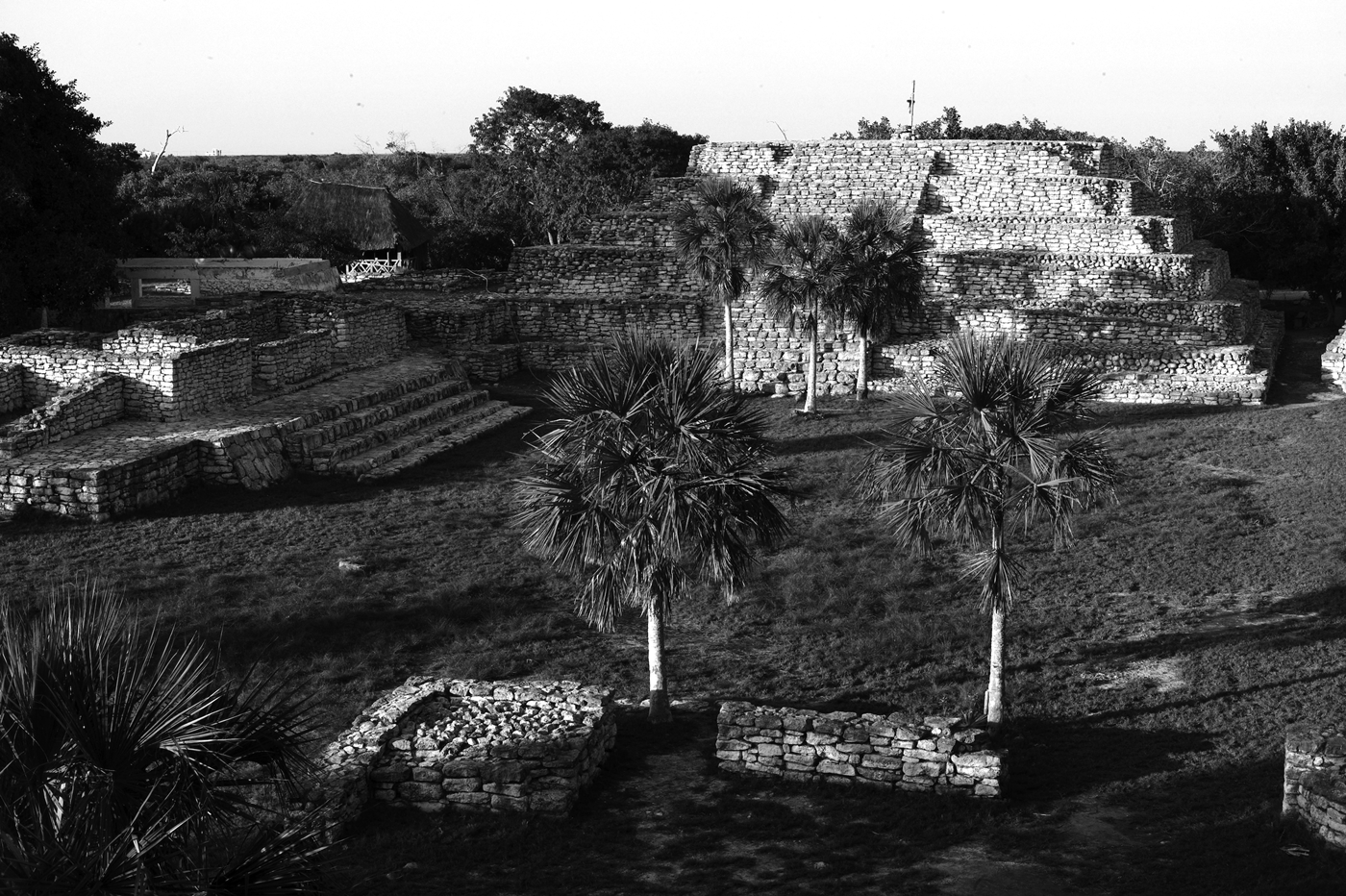
The site occupies a 700 m east-west by 150 m north-south area on top of a natural mound that was artificially expanded and raised above sea level by its settlers during the Classic period (a.d. 250–750) (Figures 2 and 3). Its constructions date to chronologically different phases. The analysis of ceramics and obsidian from the more than 300 stratigraphic test pits, and the characterization of both public and residential architectural structures, point to an uninterrupted sequence of occupation at the site spanning roughly 1,000 years. Although its initial settlement dates to the Middle Preclassic, Xcambo really prospered during the Classic period. Ceramic sequencing (Ceballos Reference Ceballos2003; Jiménez Reference Jiménez2002) distinguishes two major occupational phases, respectively, during the Early Classic period (a.d. 250–550) (Figure 4a) and the first part of the Late Classic period (a.d. 550–700) (Figure 4b), before it was swiftly abandoned shortly after a.d. 700 (Sierra Sosa Reference Sierra Sosa2004).
View of the northern part of Xcambo's reconstructed main plaza, dominated by Temple Platform NE-18. Note the modern buildings that line the coast in the background. Photo by Vera Tiesler.
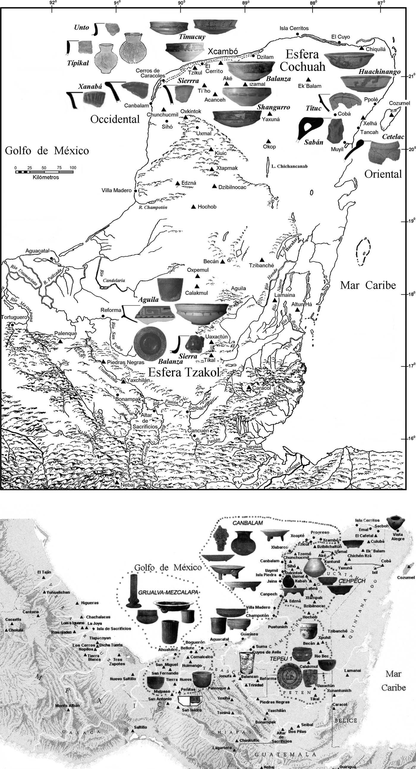
Distribution of ceramic wares at Xcambo during its two phases of occupation. (a) The ceramic distribution during the Early Classic period (a.d. 250–550), which is characterized by the Xtampu complex (after Ceballos Reference Ceballos2003). (b) The ceramic distribution during the Late Classic period, characterized by the Grijalva, Canbalam, Cehpech, and Tepeu I ceramic complexes (after Jiménez Reference Jiménez2002).

During the Early Classic period, Xcambo consisted of a small settlement core that held administrative and ceremonial functions and was surrounded by small residential platforms with patios. The foundations were built with roughly carved stones with rounded corners covered with stucco. Wood-framed huts with thatch roofs were erected on top. Daily activities such as cooking, maintenance, and so forth were carried on outside the huts. In most parts of the site, rounded, conical stone foundations supported structures that served as storage facilities (Sierra Sosa Reference Sierra Sosa2004:102–103).
Toward the onset of the Late Classic period, Xcambo experienced new prosperity, growth, and architectural transformation with all its earlier structures being built over. Expanded and densely populated residential spaces, which surrounded two public plazas, replaced earlier ceremonial architecture and the storage facilities. The central plaza was surrounded by 11 structures. Within the site, these structures are the largest, built with the finest carved stones, and their overall arrangement distinguishes them from the rest of the settlement (Sierra Sosa Reference Sierra Sosa1999a, Reference Sierra Sosa1999b) (Figure 3). Civic, religious, and administrative functions were likely carried out in this plaza and the surrounding area, specifically toward the north pier of the elevated island settlement with embarking facilities.
Toward the Late Classic period, at the easternmost limit of the site—some 250 m from the main plaza—a second small plaza surrounded by three public structures was erected. Its U-shaped arrangement leaves one side open from which a sak be (white road) leads to a residential compound some 110 m to the east that seems to represent the eastern limits of the entire settlement. Also from this secondary plaza, another sak be connected Xcambo to the inland agricultural settlements of Misnay and Cemul (Figures 1 and 2).
Due to the site's limited area above the marshlands, space was used intensively. Most of the residential compounds were erected around the plazas. Similarly, workshops, storage rooms, and areas of domestic activities were built in close proximity to one another. The older residential compounds lined up west of the main plaza. Their foundations supported stone-walled structures with straw roofs distributed around small inner patios, or laid out in contiguous quadrangles, forming a single continuous constructed compound (Sierra Sosa Reference Sierra Sosa2004).
The platforms distributed east of the main plaza differ from those in the western sector. The western sector was only leveled during the second occupational phase, to build low and wide mounds on top of which stone-walled rectangular foundations were erected for houses with wooden walls and perishable roofs. Contrary to the western sector, the houses in the eastern sector were not as numerous or concentrated. The large unroofed spaces were probably used for outdoor production and domestic chores.
The limited (re)occupation evidence dating to the Postclassic period (a.d. 1100–1543) is limited to four structures erected in the main plaza (Sierra Sosa Reference Sierra Sosa2004:166). Two miniaturized and roof-vaulted temple adoratorios are embedded in a building lining the plaza's northeast corner and held ritual functions. The remaining structures consist of two altar-platforms close to the southeastern corner. All these late structures closely resemble the East Coast style of Quintana Roo and may have served as shelters during seasonal salt gathering (McKillop Reference McKillop2002:176–181).
Artifact Distribution and Provenience
The analysis of the ceramic materials was based on the Type-Variety classification system (Ceballos Reference Ceballos2003; Jiménez Reference Jiménez2002), which is nowadays used by most archaeologists to classify pre-Columbian Maya ceramics (Gifford Reference Gifford1960; McKillop Reference McKillop2004; Smith and Gifford Reference Smith, Gifford and Willey1965). Such a taxonomic system is a practical analytical tool that establishes analogous ceramic categories by defining ceramic types, complexes, and spheres (McKillop Reference McKillop2004). A detailed comparison of analogous ceramic units (Type-Variety) from different sites provides information on the cultural ties among Maya sites through time (Gifford Reference Gifford1960; Sabloff and Smith Reference Sabloff and Smith1969; Smith et al. Reference Smith, Willey and Clifford1960). The purpose of establishing a Type-Variety system was twofold: first, to assess the chronology of ceramics at a single site or at a regional level and, secondly, to investigate diachronic relationships among sites or between regions. Firstly, the physical features of the ceramic wares were described and organized according to basic units including groups, types, and/or varieties. From there, ceramic complexes, horizons, and spheres were established and compared to other sites at regional and supraregional levels (Ceballos Reference Ceballos2003; Jiménez Reference Jiménez2002, Reference Jiménez and Cucina2013; McKillop Reference McKillop2004; Robles Reference Robles1990).
The results obtained from ceramic distribution and sequencing indicate that the port community of Xcambo had already assumed an important economic and political role during the Early Classic period (Figure 4a), and its evolution must be analyzed not as an isolated center but, rather, within a larger peninsular sociopolitical context and beyond. During the Early Classic period, the site shows unquestionable evidence of the cultural influence of the Peten region in Guatemala, which was manifested in structures found all around the Maya region, particularly in the northern Yucatan where it dominates the styles of regional capitals like Izamal (Millet and Burgos Reference Millet and Burgos2001), Yaxuna, Oxkintok, or Ti'ho. During this time, Izamal controlled—politically and economically—a vast territory, and likely watched over the communities along the northeastern and northern coast, as well as the goods produced or traded there. It is likely that Xcambo was part of such a network and that its main functions were directed toward the administration of salt production and procurement of marine goods and, to a lesser extent, the trading of local and regional products. Many elements, in fact, hint at Xcambo's Early Classic period role as a trading port. Both the public and residential structures there manifest Peten-style architecture and megalithic Izamal features. The personal attire and outfitting of the deceased were abundant; with many burials containing ceramic vessels imported from areas outside the Maya shpere (Medrano Reference Medrano2005). Unlike any other coeval coastal sites explored so far, Xcambo exhibits a highly diversified range of local ceramic types including Tipikal, Unto, Saban, Hubila, Xanaba, Shangurro, and Timucuy, among others (Ceballos Reference Ceballos2003; Smith Reference Smith1971). The majority of the abundant foreign ceramics were determined to have originated from the east coast; namely the Huachinango, Cetelac, Tancah, Habana, and Tituc groups (Canché Manzanero Reference Canché Manzanero1992; Ceballos Reference Ceballos2003; Peraza Lópe Reference Peraza Lópe1993; Robles Reference Robles1990) (Figure 4a).
Regarding Xcambo's Early Classic period transportation routes, the presence of elevated roads (sak be'oob) demonstrate ample communication with inland communities. The presence of a pier connecting the site to the seaside marshland and the open sea reflects activities related to receiving and shipping trade goods, as also demonstrated by the presence of monochrome and polychrome vessels from Campeche, the Guatemalan Peten and Belize, among which stand out the Triunfo, Balanza, Águila, and Pucte groups, and polychrome vessels from the north of Quintana Roo, including the Tituc variety. Lithic material includes obsidian from El Chayal, located in the Guatemalan highlands, and green stone artifacts from the Guatemalan Peten (Ceballos 2003; Forsyth Reference Forsyth1983; Sierra Sosa Reference Sierra Sosa2004; Smith and Gifford Reference Smith and Gifford1966).
At the onset of the Late Classic period, the Maya world experienced a series of regional changes at the expense of the older, more localized economic and political structure that prevailed in the Early Classic period in the Yucatan. It is then that Xcambo appears to have both redirected and expanded its trade connections. Large numbers of Early Classic ceramic vessels found at the site—particularly the Chum, Muna, Ticul, Teabo, Batres, Hunabchen, Chuburna, Maxcanu, Baca, Nimun, Dzitbalche, Cui, Chukul, Chimbote, Charote, Vista Alegre, Arena, and Chumul ceramic groups—belong to the Cambalam and Cehpech spheres, testifying to relationships with the Puuc and Chenes areas of northwestern Yucatan, as well as with the northeastern parts of the Yucatan Peninsula (Ball Reference Ball and Ball1975a, Reference Ball1975b, Reference Ball, Eaton and Ball1978; Peraza Lópe Reference Peraza Lópe1993; Robles Reference Robles1990; Simmons Reference Simmons1980; Smith Reference Smith1955, Reference Smith1958, Reference Smith1971) (see Figure 4b). Conversely, no ties with the Caribbean coastal fringes of Yucatan toward the east appear in the site's ceramic assemblage during the Late Classic period.
Close relationships were maintained during the Late Classic, however, with the southern inland elite of the Mexican and Guatemalan Peten, as demonstrated by the presence of ceramics from the Tepeu 1 sphere. In this same timeframe, unusually high quantities of high-quality Fine Grey, Fine Orange, Fine Brown, and Fine Cream ceramics from Tabasco (Berlin Reference Berlin1960; Jiménez Reference Jiménez and Cucina2013; Smith Reference Smith1958) and the northern Chiapas region appear, testifying to the intensity of trade with this part of the Gulf of Mexico (Jiménez Reference Jiménez2002, Reference Jiménez and Cucina2013; Sierra Sosa Reference Sierra Sosa2004).
With respect to Fine Grey ware, Jiménez (Reference Jiménez and Cucina2013) mentions that this, as well as other types and varieties, must be characterized in relation to its chronology. For the Chablekal (Fine Grey) ceramics specifically, three different phases are identified: Early, Intermediate, and Late, which she asserts correspond to different chronological periods and places of origin. Jiménez (Reference Jiménez and Cucina2013) indicates that the Fine Grey phase from Xcambo corresponds to the Early Chablekal ceramics, dating to a.d. 550/650–750. This typology, which adheres to the panregional coastal trade system that at that time encompassed an area extending from Veracruz to Yucatan, manifests strong connections with the fine paste wares of the Villalta phase from sites located along the Coatzalcoalcos River in Veracruz and, to some extent, to the Early Mezcalapa and Grijalva style from the Comalcalco area in Tabasco (Jiménez Reference Jiménez and Cucina2013; Jiménez et al. Reference Jiménez, Sosa, Seu and Caso2006) (Figure 4b).
Fine-paste and domestic ceramics of the “Choles” region of the Usumacinta River also made their way to Xcambo during this time. These well-documented ceramics belong to the Balancan, Calatraba, Pozarrica, Cocoyoles, and Hunal groups (Jiménez Reference Jiménez2002). Finally, contacts with the “Zoque” from southern Veracruz are also evinced by the presence of local ceramic wares from that area, as well as with the Laguna de Términos region and parts of central Veracruz (Jiménez Reference Jiménez and Cucina2013).
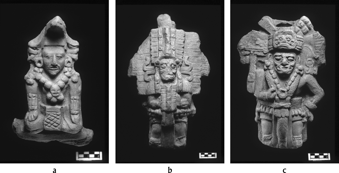
Polychrome wares and terracotta figurines included among the funerary equipment of Xcambo's dead also testify to its far-reaching ties (Figure 4b and Figure 5b). All 23 complete and 97 fragmented figurines from graves belong to the Late Classic period “Dzibalche” style, which originated on the Gulf Coast and has been associated with merchant investitures. The obsidian from this occupational phase comes mainly from El Chayal and Ixtepeque sources located in Guatemala. Lesser quantities originated from Zaragoza, Puebla, Hidalgo, and Ucareo in Michoacan, and were likely distributed through the Gulf Coast (Braswell Reference Braswell2002). This distribution differs significantly from the predominance of highland sources that supplied Chichen Itza at this time (Braswell Reference Braswell, Laporte and Escobedo1997, Reference Braswell2002). Beyond obsidian, other exotic lithics including jadeite, turquoise, basalt, and pyrite artifacts are all trade goods that were well represented at Xcambo during the Late Classic period.
Late Classic period terracotta figurines from Xcambo: (a) Structure NE-18 (5-XXV), (b) Structure NE-7a, Burial 21, (c) Patio IX, Burial 313.
THE BIOARCHAEOLOGY OF XCAMBO
A large mortuary population at Xcambo was recovered as part of the general excavation efforts during the 1990s (Medrano Reference Medrano2005; Sierra Sosa Reference Sierra Sosa2004). The excavation and recovery of more than 500 burials followed standard recording techniques, complemented by photo-interpretations of positioning and the associated burial environment (Duday Reference Duday2009). The 538 skeletons include 338 individuals dating from the Late Classic period and 82 more from the Early Classic period. Sex in the adult segment of the population was determined on the basis of dimorphic features in the skull and pelvis, following standard procedures laid out in Buikstra and Ubelaker (Reference Buikstra and Ubelaker1994). Age-at-death determination of subadults was based on stages of dental formation and eruption, long-bone length, and epiphyseal fusion (Buikstra and Ubelaker Reference Buikstra and Ubelaker1994). Adult age-at-death was estimated through the analysis of degenerative changes in the pubic symphysis (Brooks and Suchey Reference Brooks and Suchey1990), in the auricular surface of the ileum (Lovejoy et al. Reference Lovejoy, Meindl, Pryzbeck and Mensforth1985), in the sternal end of the fourth rib (Iscan et al. Reference Iscan, Loth and Wright1984, Reference Iscan, Loth and Wright1985), and the degree of closure of ectocranial sutures (Meindl and Lovejoy Reference Meindl and Lovejoy1985). Histomorphological analyses followed the parameters set forth in Stout and Paine (Reference Stout and Paine1992) and Valencia and colleagues (Reference Valencia, Cucina and Tiesler2010; see also Suzuki et al. Reference Suzuki, Cucina, Tiesler, Sierra, Laporte, Arroyo and Mejía2009).
Burial Population
The burial pattern at Xcambo is rather homogeneous with mostly well-equipped burials in simple or cist graves. Many of the graves contained imported ceramic vessels and figurines, along with diverse local or imported items of personal adornment (Medrano Reference Medrano2005; Sierra Sosa Reference Sierra Sosa2004). Xcambo's burial practices did not change substantially over time. On average, 13.8% of the skeletons presented different amounts of pigment, which appears distributed mostly over the long bones. The use of cists as funerary containers was not very popular throughout the site, particularly in the central, administrative, and western compounds, but reached a frequency peak of 58.3% in the eastern sector. No differences in the use of cist graves could be noted between the two periods, with 6.7% occurring during the Early Classic period and 7.2% in the Late Classic period. Two-thirds of the burials are in the extended dorsal position, while only about one-third are flexed—either on the left or the right side—and sex or age at death was not a contributing factor in the determination of burial positioning. A slight decrease in extended body position is noted for the Late Classic period (59.3% vs. 72.5% in the Early Classic) when a variety of different flexed body positions are adopted (Medrano Reference Medrano2005).
A clear change, however, can be highlighted between primary and secondary burials. The latter dropped from 88.2% (during the early phase) to 73.8% in the Late Classic period. Yet, such change does not necessarily imply a shift in burial customs, possibly introduced by the adoption of foreign practices; instead it can be explained by the fact that Xcambo's population continued to grow during the Late Classic, with more people living (and being buried) at the site, and new structures being erected. In this context, redeposition of human remains most likely ensued as a result of circumstantial (rather than ritual) interference with previous burials during the excavation of new graves or of the foundations for new platforms.
Distribution of Sex and Age at Death
Adult males and females are equally represented in both Early and Late Classic period samples. In both occupational periods, their proportion approaches 1:1 when individuals with well-preserved iliac bones are scored (Tiesler et al. Reference Tiesler, Cucina, Sierra, Falla and Meindl2005). Apart from fertility, demographic parameters appear to indicate a high level of infant mortality, with almost 50% of the entire sample representing infants that died during the first five years of life (Tiesler et al. Reference Tiesler, Cucina, Sierra and Meindl2004, Reference Tiesler, Cucina, Sierra, Falla and Meindl2005). The reasons for such a high rate of infant deaths, which is also indicative of a growing population (Sattenspiel and Harpending Reference Sattenspiel and Harpending1983), is tracked by scholarship related to weaning, infectious diseases, and other pathological conditions commonly responsible for premature deaths in preantibiotic populations (Reyes et al. Reference Reyes, Tiesler, Cucina and Sierra2006; Sattenspiel Reference Sattenspiel2000). Once past the weaning age, however, it appears that Xcambo's healthy population enjoyed a long life span, which is evidenced by the high proportion of elderly individuals, who survived well past 50 years of age.
Lifestyle and Physiological Stress
The environmental impact on those who survived the early years of life has been highlighted by Mendez and colleagues (2009), who reported an elevated amount of physiological developmental stress in the form of linear enamel hypoplasia (LEH) in this coastal, tropical population, and by Cucina (Reference Cucina2011), whose LEH analysis documented that, with few exceptions, those who managed to survive the early, critical years of life suffered the same risk of dying during subadulthood or after reaching adulthood.
Although LEH is commonly associated with nutritional deprivation (Goodman et al. Reference Goodman, Armelagos and Rose1980; Goodman and Rose Reference Goodman, Rose, Kelley and Larsen1991;), in the case of Xcambo such high levels of developmental stress can hardly have been a result of malnutrition, as the dietary chemical analyses attest (see below). The skeletal analyses indicate a population that was on average slightly taller than most Maya inland groups, a tendency that has been associated with better nutritional conditions likely associated with greater marine protein intake, as evidenced by the large amount of terrestrial and marine skeletal remains encountered at the site (Sierra Sosa Reference Sierra Sosa2004; Tiesler Reference Tiesler2001; Tiesler et al. Reference Tiesler, Tejeda, Sierra, Laporte, Escobedo and Arroyo2002). It is unmistakable that diet was fairly well balanced between carbohydrate and protein consumption, as the combined evidence of a high level of carious lesions and zooarchaeological remains indicate (Cucina et al. Reference Cucina, Perera, Sierra and Tiesler2011b; Götz Reference Götz2006; Götz and Sierra Reference Götz and Sierra2012). Such a balanced diet was also inferred by the low frequency of skeletal markers of nutritional stress, such as cribra orbitalia and porotic hyperostosis, whose frequencies (16.6% and 18.9%, respectively) are clearly below most other Maya contexts (Cetina and Sierra Reference Cetina and Sierra2005).
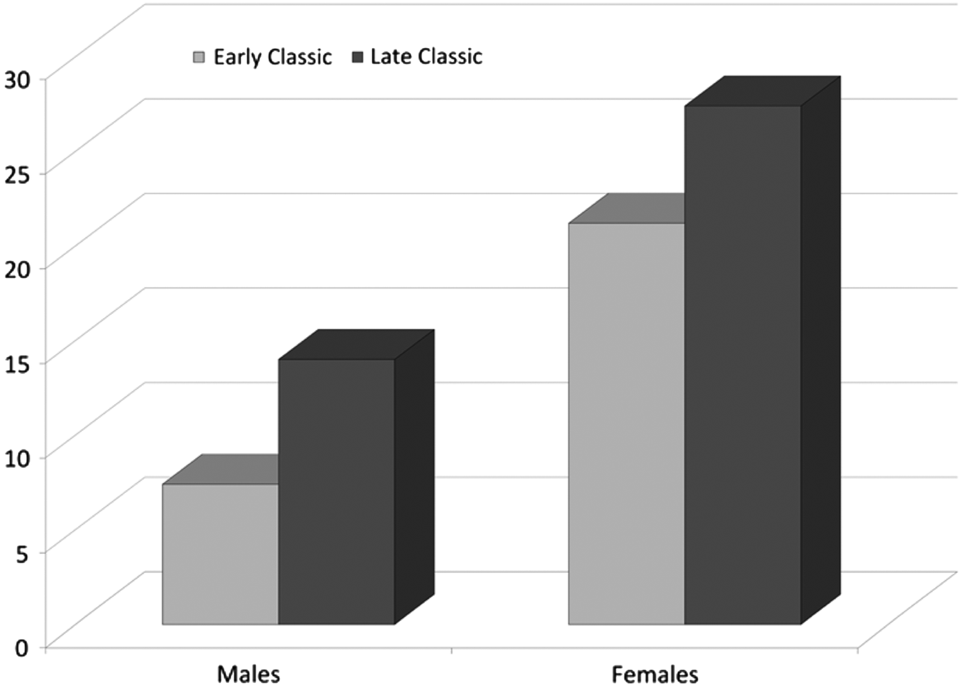
The overall picture of this costal pre-Columbian community is one of a relatively well-fed population that proliferated at an increasingly prosperous site for several centuries, especially during the second phase of continuous occupation in the Late Classic period (a.d. 550–700). Yet the improved economic conditions did not appear to relieve physiological stress, as demonstrated by the LEH analyses (Méndez et al. Reference Méndez, Sierra, Tiesler and Cucina2009). In fact, these changing conditions triggered a dramatic rise in cariogenic oral pathologies. Carious lesions, a common disease associated with carbohydrate consumption (Lukacs Reference Lukacs and Iscan1989), notably increased from the Early to the Late Classic period in both sexes at Xcambo (Figure 6). Here such a high rate of carious lesions cannot be simply explained by a shift toward a maize-based diet. Instead, as argued elsewhere (Cucina et al. Reference Cucina, Perera, Sierra and Tiesler2011b), the lesions appear as a consequence of increased consumption of sweetened foodstuff, such as honey, which was locally produced.
Frequency of carious lesions by sex and chronological period in the adult segment of the population of Xcambo.
At the same time, Wanner and colleagues (Reference Wanner, Sosa, Alt and Tiesler2007) and Maggiano and collegues (2008), on the basis of skeletal occupational markers, noted a significant decrease in the physical regimen of males moving from the Early into the Late Classic period phases of occupation, while that of the females essentially remained the same. Such a decrease in male physical activity has been associated with increased administrative functions and wealth on the artificial island of Xcambo, which did not demand as much hard physical labor for subsistence and salt production from its men as it had during the Early Classic period.
Artificial Head Shapes
As we have argued elsewhere (García and Tiesler Reference García and Tiesler2011; Tiesler Reference Tiesler2010, Reference Tiesler2011, Reference Tiesler2012, Reference Tiesler2014; Tiesler and Cucina Reference Tiesler, Cucina, Hernández and Pool2010) that artificially produced head shapes constituted a widespread and highly visible body emblem of Maya group identification, especially during the Classic period, when culturally modified head forms reached a peak both in popularity and diversity. Unlike most other forms of body modification, cranial vault modeling bridges the generations, as it is performed by second- or third-generation adult practitioners on their infant kin who then carry the resulting artifical head shape for the remainder of their lives. This protracted, conservative quality of head modeling raises the social importance of this practice above that of more ephimeral, transitory body fashions and turns it into an enormously useful trait for examining longue durée (long-term) cultural dynamics, expressions of group ancestry and ethnicity, social integration, and embodied group identity (Tiesler Reference Tiesler2011, Reference Tiesler2012, Reference Tiesler2014). As head shaping leaves traces in archaeologically human skeletal remains, it can be studied and contextualized from the archaeological record.
For this study, we used head shape as a potential marker of ethnic identity and provenience, given that preferences in head form varied visibly according to region and timeframe among the Classic period Maya. Some 371 skulls were preserved well enough to be analyzed, at least in terms of presence or absence of this practice. To characterize the artificially modelled skulls, both formal (morphological) and procedural (technical) criteria were used, which are extensivley described elsewhere (see Tiesler Reference Tiesler2012). The taxonomy, which goes back to the work of José Imbelloni (Dembo and Imbelloni Reference Dembo and Imbelloni1938; Romano Reference Romano1965), distinguishes between tabular erect forms, attributed to the use of cradleboards, while the fitting of free compression boards on the infant head usually results in receding tabular oblique forms. The duration of compression force and the amount of pressure applied determine the severity of the morphological changes. Hard compression devices may be combined with constricting bands or a superior compression plane, each leading to specific morphological results.
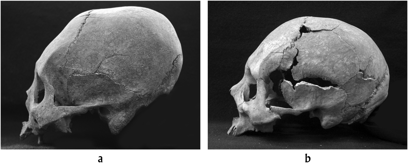
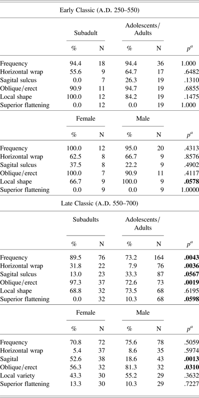
During the Early Classic period, some 94% of Xcambo's population sported artificially modified crania. And the local oblique form is seen in more than 90% of the modified individuals (Figure 7a; Table 1). This form consisted of a reclined forehead and an elongated oblique skull vault with two flattened areas at the back, which was uniformly seen in adults, children, and infants during this occupational period. This pattern changes toward the Late Classic, which witnesses a significant (p = .006) drop in artificially modified head forms (73.2% in the adult population) (Table 1). This later occupational period also demonstrates a greater variety of head shapes, including a trend toward erect forms, which again is significant for the adult segment (p = .0406). Superior flattening made its debut in the headforms of Xcambo's settlers in the Late Classic period (Figure 7b). Here, some 10.3% of adolescents and adults show this distinct form, which has also been described for other coastal Maya populations after a.d. 500 (Tiesler et al. Reference Tiesler, Romano and Pallán2010). Interestingly, this form also appears at Mixtequilla sites, in Veracruz, where it has been identified as “El Zapotal” modification by Romano (Reference Romano, Gutierrez and Hamilton1977), who first described these distinct vault shapes 40 years ago.
Examples of (a) Xcambo's local tabular oblique head shape (Burial NE-14/1) in lateral view, and (b) Late Classic period cranial modification with superior flattening in lateral view (from Burial NE-35/135). Photos by Shintaro Suzuki.
Frequencies of artificial head shapes at Xcambo according to chronological placement, age, and sex
aSignificant p values (<p = .05) highlighted.
When Late Classic adult and subadult head forms are compared, the results show significant differences in almost all of the examined criteria (Table 1). While Late Classic subadults continue to present local oblique shapes (97.3%), adults show a much broader range of shapes when compared to the previous occupational phase. These differences are perhaps best explained by the fact that infants and children, due to their young age, had less time and therefore were less likely to have moved from one place to another when compared to adults. Many adults, in turn, are categorically more likely to be of foreign origin, based on the fact that their head forms differed from locally preferred shapes. This scenario, to be confronted by isotopic measurements in the first molar (see next section), suggests a higher degree of immigration and mobility in those who died at Xcambo during the Late Classic period, and, at the same time, points toward prompt cultural adoption of local head-shaping devices by foreign female newcomers (Tiesler and Cucina Reference Tiesler, Cucina, Hernández and Pool2010:129–132).
THE CHEMICAL SIGNATURES OF XCAMBO'S DIET AND PROVENIENCE
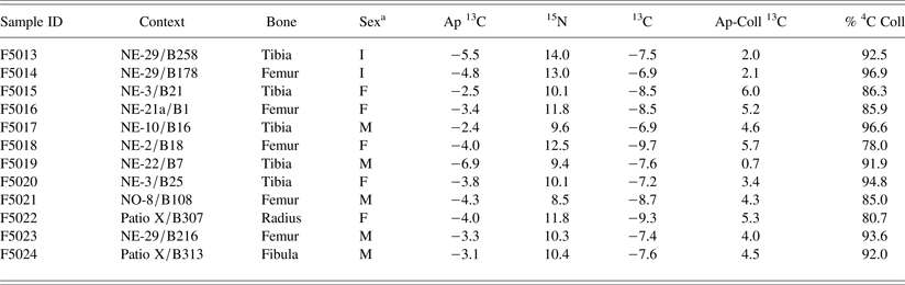
Chemical analyses of bone and teeth provide information on diet and origin of past individuals (Ambrose and Katzenberg Reference Ambrose and Katzenberg2001; Montgomery Reference Montgomery2010). Carbon and nitrogen isotopes have been employed to address questions regarding ancient dietary components and subsistence patterns (see, for example, Tykot Reference Tykot and Jakes2002). Strontium (and oxygen) isotopes have been used extensively in the study of past human movement in Mesoamerica (Price et al. Reference Price, Manzanilla and Middleton2000, Reference Price, Burton, Fullagar, Wright, Buikstra and Tiesler2008; Wright Reference Wright2005). Baseline maps for parts of the central highlands of Mexico and the Maya region have been published (Hodell et al. Reference Hodell, Quinn, Brenner and Kamenov2004; Price et al. Reference Price, Burton, Fullagar, Wright, Buikstra and Tiesler2008). Here we summarize the results of isotopic analyses of the human remains from Xcambo (Table 2).
Isotope ratios and apatite-collagen spacings for the 12 individuals analyzed in the skeletal collection
aI = indeterminate; F = female; M = male
Past Diet: Carbon and Nitrogen in Bone Collagen and Apatite
The measurement of carbon isotope ratios in bone collagen is well known in the study of marine resources and C4 plants (maize) in human diets (Schoeninger and DeNiro Reference Schoeninger and DeNiro1984; Tauber Reference Tauber1981; Van der Merwe and Vogel Reference Van der Merwe and Vogel1978). Carbon from the mineral (carbonate) portion of bone and tooth enamel also contains information on diet (Cerling and Harris Reference Cerling and Harris1999; Sullivan and Krueger Reference Sullivan and Krueger1981), and nitrogen isotope ratios tell us about the importance of meat in the diet, the role of freshwater fish, and the trophic level of human diets. The isotopes of carbon and nitrogen are expressed as the ratios 13C/12C and 15N/14N to a reference material. Carbon is reported as per mil values of δ13C and nitrogen as δ15N. Naturally occurring δ13C numbers for biologically interesting carbon compounds are negative in value and range from roughly 0 to –25‰. There are two primary sources of variation in δ13C in the human diet and bone collagen: in the kinds of plants we eat and between terrestrial and marine foods. δ13C is more abundant in certain kinds of tropical plants, such as corn, and in the oceans. Thus, less negative values for collagen in bone indicate either marine foods, C4 plants in the diet, or both. Nitrogen is also measured in bone collagen; values of δ15N in human bone range from approximately −5‰ to +10‰, and reflect the trophic level. A more positive nitrogen isotope ratio generally reflects a higher trophic position. Carbon and nitrogen isotopes in bone collagen together provide information about diet during the last 10 − 20 years of life due to chemical turnover during bone remodelling.
Krueger and Sullivan (Reference Krueger, Sullivan, Turnland and Johnson1984) initially documented the difference in stable carbon isotope ratios between the apatite and collagen compartments of bone in the same individual. They proposed that consumer collagen carbon was derived from dietary protein, while apatite reflected the isotopic composition of the whole diet. They used this model to explain systematic differences in the isotopic composition of collagen and apatite of nonhuman herbivores versus carnivores and omnivores, and marine versus terrestrial human diets. Apatite carbon isotope ratios in enamel reflect the diet of early childhood, while bone apatite ratios are a composite of the last 10−20 years of life. Controlled diet experiments confirmed the fundamental aspects of their model (Ambrose and Norr Reference Ambrose, Norr, Lambert and Grupe1993; Jim et al. Reference Jim, Ambrose and Evershed2004; Tieszen and Fagre Reference Tieszen, Fagre, Lambert and Grupe1993). This demonstrated that when the protein and bulk diet have the same δ13C values, collagen is enriched by 5.0‰, apatite is enriched by 9.4‰ relative to the total diet, and the apatite-collagen spacing (δ13Cap-coll) is 4.4‰.
Specifically, protein-rich marine foods, like the ones we expect to have been consumed at Xcambo, contribute disproportionately to the amino acids in collagen compared to terrestrial plants. Moreover, being enriched in 13C, marine proteins will disproportionately increase the collagen δ13C values relative to the bulk diet and relative to apatite δ13C. In marine contexts with no C4 plants, protein comes mainly from 13C-enriched marine animal resources, while carbohydrates and some proteins come from 13C-depleted C3 plants and C3-feeding animals. Because the marine protein source is more enriched in the heavy carbon isotope, the diet-to-collagen spacing (δ13Cdiet-coll) should be greater than 5‰, and collagen to carbonate spacing (δ13Cap-coll) should be less than 4.4‰. Because the marine protein source is more enriched in 15N, collagen δ15N values should also be high. In a coastal environment lacking C4 plants, a positive correlation should exist between collagen δ13C and δ15N, and a negative correlation should occur between δ15N and δ13Cap-coll (Ambrose et al. Reference Ambrose, Butler, Hanson, Hunter-Anderson and Krueger1997; see also Ambrose and Norr Reference Ambrose, Norr, Lambert and Grupe1993; Harrison and Katzenberg Reference Harrison and Katzenberg2003; Jim et al. Reference Jim, Ambrose and Evershed2004; Tykot et al. Reference Tykot, Falabella, Planella, Aspillaga, Sanhueza and Becker2009).
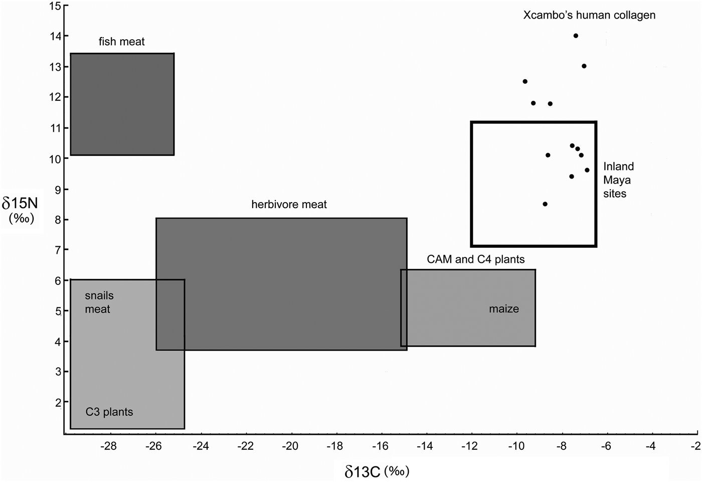
In the present prospective study on the Xcambo collection, a small, albeit representative, sample of 12 individuals, which are mainly dated to the Late Classic period, was selected for carbon and nitrogen in-bone collagen, as well as for oxygen isotopes and apatite carbon and oxygen. The sample was processed by Stanley Ambrose at the Stable Isotope Laboratory (University of Illinois Champagne-Urbana). These data are presented in Table 2 and characterize general local dietary habits at Xcambo. The δ13C values exhibit a narrow range, between −6.9 and −9.7, with a mean value of −8.0; the δ15N values range from 8.5 to 14.0 with a mean of 10.9. In general, the very positive δ13C values point to a diet high in maize and other C4 plants, as well as the possibility of marine foods in the diet. The variation in δ15N‰ is more pronounced, and higher values may reflect a diet containing more meat or fish. Since a diet based on terrestrial meat hardly overpasses a δ15N of 11 (Wright Reference Wright2006), however, the higher values at Xcambo seem to indicate a diet based on marine proteins (fish), as Figure 8 indicates.
Scatterplot representing δ13C and δ15N values for the 12 individuals from Xcambo compared with isotopic distribution from various inland Maya sites (after Wright Reference Wright2006:193) and isotopic general values from C3, C4, herbivores and fish meat (after Wright Reference Wright, Whittington and Reed1997:187).
On the contrary, bone apatite carbon isotope ratios vary from −2.4 to −6.9, with a mean of −4.0; the apatite-collagen spacing values range from 0.7 to 6.0 with a mean of 4.0. Such spacing, along with the nitrogen isotope ratios from bone collagen suggest a diet based largely on maize, with estimated consumption rate ranging from 78–96%. Values for δ15N and δ13C are plotted together in Figure 8 in comparison with isotopic values from different inland sites in the Maya region (Wright Reference Wright2006) and according to the expected distribution of C3 and C4 (terrestrial and marine proteins, respectively). The distribution of values is generally linear with a relatively small range of values, with the exception of three outliers. Two of these outlying individuals (Burials NE-29/178 and NE-29/258) have distinctively high nitrogen values, while the remaining individual (NO-8/ B108) has the lowest nitrogen value among the samples. Burial NE-2/18 may also be somewhat distinctive given its most negative δ13C. Unfortunately, we do not have strontium isotope data from these same individuals to compare with differences in provenience.
There are a number of investigations of collagen carbon in human remains from Mesoamerica (for example, Tykot Reference Tykot and Jakes2002; White et al. Reference White, Longstaffe and Law2001a, Reference White, Pendergast, Longstaffe and Law2001b; Wright and Schwarcz Reference Wright and Schwarcz1998). The results of these studies generally point to menus dominated by maize, and to some differences with less maize and more protein in elite diets. Among the comparative data presented by Wright (Reference Wright2006), and whose range of distribution appears in Figure 8, the distribution of the 12 individuals from Xcambo seems to generate two patterns. The first falls within the typical carbon and nitrogen range of variability among inland Maya samples, indicating a diet based on maize but with consistent intake of animal proteins, as Wright (Reference Wright2006) also indicates for her samples from the Pasión region, located in the Maya lowlands, Guatemala. The second, which includes five individuals from Xcambo, falls above such range of variability, particularly with regard to the nitrogen values, which indicate that alongside a diet based on maize, their intake in animal (marine) proteins was also well above that of the other individuals.
A further study of 25 samples from Yaxuna and Chunchunmil in the northern Maya lowlands—the former representing an inland context and the latter closer to the coast (Mansell et al. Reference Mansell, Tykot, Freidel, Dahlin, Ardren, Staller, Tykot and Benz2006)—are of direct interest for this analysis. The results suggest significant differences between the two sites, with the residents of the more inland site being more dependent on maize. There was also greater dietary variation among the individuals at the near coastal site, perhaps because of the availability of diverse resources and differences related to social status. Overall, the chemical composition of bone collagen in the sample from Xcambo seems to confirm the idea of a balanced diet with a consistent intake of marine proteins as well as maize. The current lack of information on potential differences between sexes and the two chronological phases of (continuous) occupation limit the interpretation of the results at this stage.
Past Movement: Strontium and Oxygen
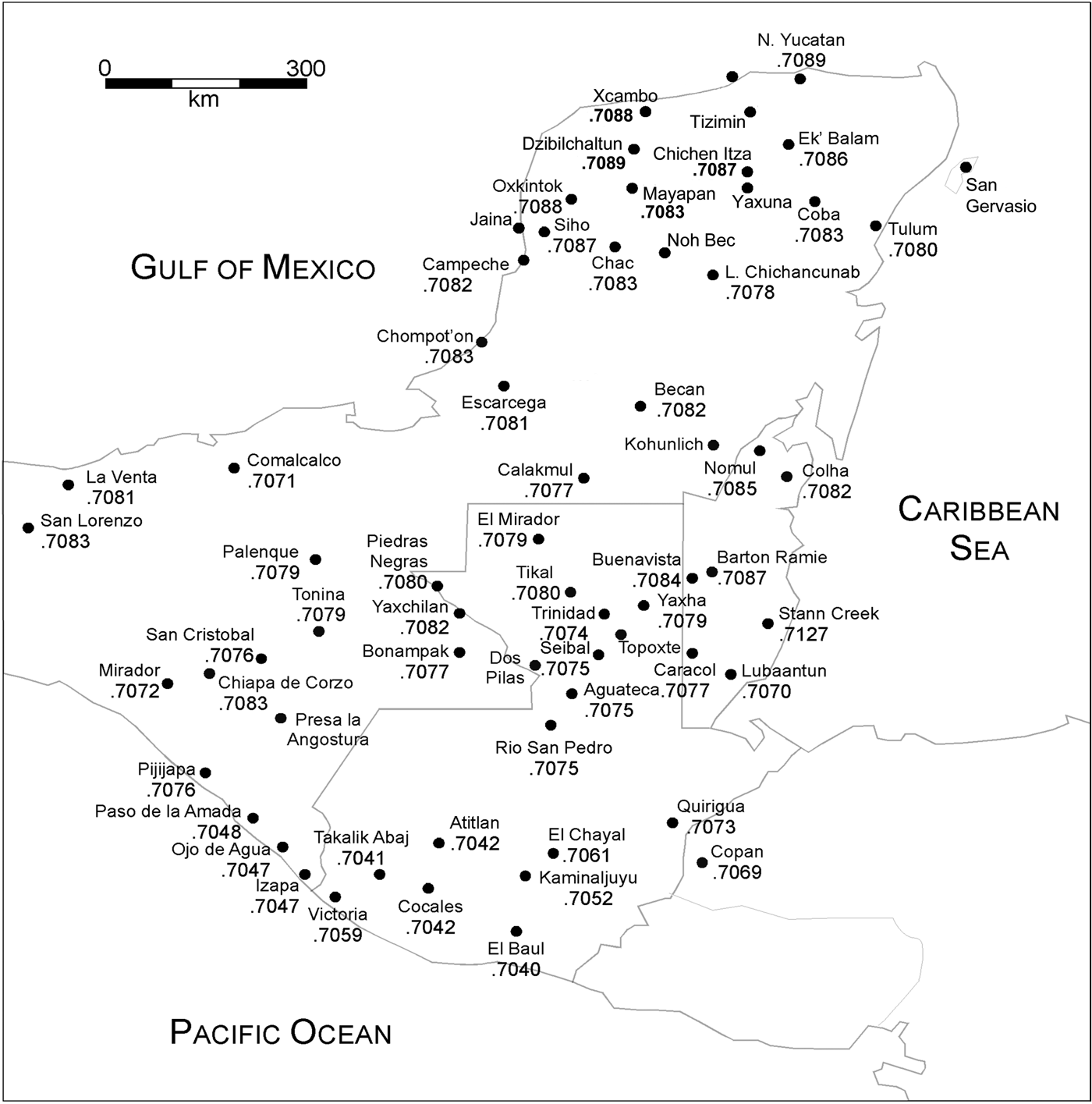
The use of strontium isotopes to study human mobility relies upon geographic variation in 87Sr/86Sr and the fact that this ratio is maintained in diet essentially unchanged from the environmental ratio. When dental enamel develops during the first few years of life, it traps this local ratio and keeps it unchanged into adulthood and after death. By comparing the 87Sr/86Sr in teeth to that of the local ratio, we can identify individuals whose teeth have different ratios and, thus, who must have migrated to the site from a region that presents such a different strontium ratio. Figure 9 shows the distribution of 87Sr/86Sr values in the Maya region. (For specific information on the geological nature of the different parts of the Maya realm, see Hodell et al. [Reference Hodell, Quinn, Brenner and Kamenov2004]; Price et al. [Reference Price, Burton, Fullagar, Wright, Buikstra and Tiesler2008]; and Torres-Alvarado et al. [Reference Torres-Alvarado, Verma and Carrasco-Nuñez2000].)
Distribution of 87Sr/86Sr ratios in the Maya area.
Distinct from strontium, oxygen has three isotopes, 16O (99.762%), 17O (0.038%), and 18O (0.2%), all of which are stable and nonradiogenic. Oxygen isotopes, in opposition to strontium, are much lighter and have a much greater relative mass difference than strontium isotopes, making them highly sensitive to environmental and biological processes. Oxygen isotopes, reported as difference in 18O/16O between a sample and a standard, can be measured in either the carbonate (CO3)−2 or phosphate (PO4)−3 ions of bioapatite. This value is designated as δ18O.
Oxygen isotopes in the skeleton reflect that of body water (Luz and Kolodny Reference Luz and Kolodny1985; Luz et al. Reference Luz, Kolodny and Horowitz1984), which in turn predominantly reflects that of local rainfall. Isotopes in rainfall are greatly affected by enrichment or depletion of the heavy 18O isotope relative to 16O in water due to evaporation and precipitation. Major factors affecting rainfall isotope ratios are geographic and include latitude, elevation, and distance from the evaporation source (for example, an ocean). Lachniet and Patterson (Reference Lachniet and Patterson2009) showed an inverse correlation between rainfall amount and δ18O. Additional information on oxygen isotopes in groundwater across Mexico (Wassenaar et al. Reference Wassenaar, Van Wilgenburg, Larson and Hobson2009) shows δ18OVSMOW values of −4 to −5‰ for the entire Yucatan Peninsula. Using the equation δ18O ap(PDB) = 0.653 × δ18O W(VSMOW) + 0.09, derived from Iacumin et al. (Reference Iacumin, Bocherens, Mariotti and Longinelli1996) and Longinelli (Reference Longinelli1984), this corresponds to apatite (PDB) values of approximately −3‰.
Like strontium, oxygen is incorporated into dental enamel during the early life of an individual where it remains unchanged through adulthood. Oxygen isotopes have been employed in a number of studies in Mesoamerica (Spence et al. Reference Spence, White, Longstaffe and Law2004; White et al. Reference White, Spence, Stuart-Williams and Schwarcz1998, Reference White, Longstaffe and Law2001a, Reference White, Pendergast, Longstaffe and Law2001b, Reference White, Spence and Longstaffe2004; Wright and Schwarcz Reference Wright and Schwarcz1998). Because 87Sr/86Sr and δ18O respond to different geographical variables, the use of both isotopic ratios together can sometimes place stronger constraints on the place of birth.
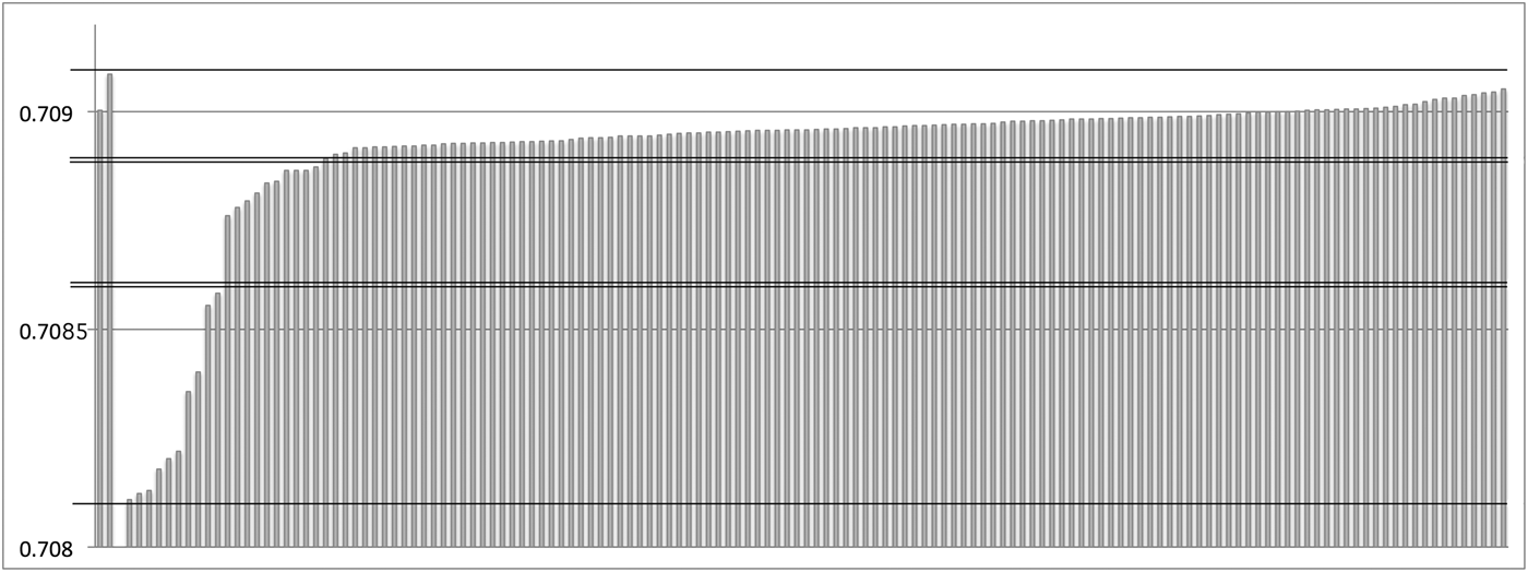
We measured 87Sr/86Sr isotopic signatures from dental enamel in 133 specimens from Xcambo's burial cohort. Our results are presented graphically in Figure 10. The individual bars in this graph represent individual human enamel samples from the site. The first two values come from modern animals collected at the site to obtain some direct baseline information. The faunal values are quite high at 0.7090 and 0.7091 and document the maximum levels of 87Sr/86Sr found in the Yucatan Peninsula. Seawater, the highest source of 87Sr/86Sr in the Yucatan, has a constant value of 0.7092.
Graphic representation of the 87Sr/86Sr values in the samples from Xcambo. Horizontal lines separate the three ranges mentioned in the text.
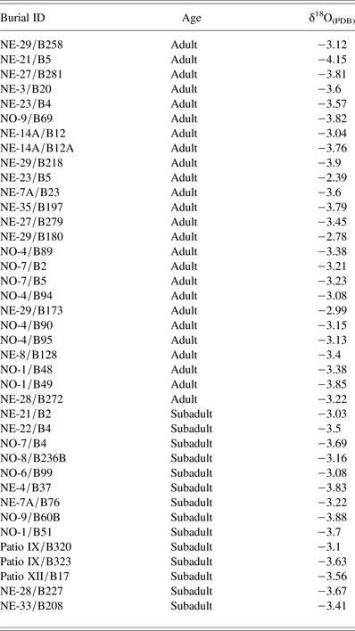
Our results indicate that 111 of the 131 scored residents from Xcambo, including all but one from the early phase, fall into the local strontium range, between 0.7089 and 0.7092. Similar results were also obtained on the basis of trace element composition of first permanent molars (Cucina et al. Reference Cucina, Tiesler, Sierra and Neff2011a). This range also encompasses much of the west and northern coast of Yucatan, stretching from Isla Jaina, on the west coast of Yucatan, to Isla Cerritos, some 110 km east of Xcambo. Ten more people fall in the 0.7087 to 0.7088 range, identified most probably with the neighboring inland areas of the northern Yucatan. Nine of these date to the Late Classic period, and only one individual to the Early Classic. Ten more men and women, all dated to the Late Classic period, fall in the 0.7081 and 0.7086 range, with a gap devoid of samples between 0.7082 and 0.7084. These low values are not observed in faunal remains and rarely in human values from sites north of approximately 19°N, nor from sites south of Calakmul. As a result, we suspect that these individuals came from the lower coastal fringes of the Yucatan or central Maya lowland inland areas, also given the results obtained from oxygen measurements (Table 3).
Oxygen isotopic values for 39 analyzed individuals from Xcambo
One of the foreign immigrants, as determined from the strontium signature (NE − 23/Burial 5; δ18O = 2.39 ‰PDB; 87Sr/86Sr = 0.7082), has the heaviest δ18O of the 39 samples measured for oxygen (Table 3), consistent with an origin in the southern interior, somewhere in the Peten or Usumacinta area. The remaining individuals for whom oxygen isotopes were measured in dental enamel have a relatively narrow range of approximately −3 to −4 ‰PDB, which is typical of the northern parts of the Yucatan.
DISCUSSION
Our combined results from the Xcambo site provide insights into the local economic dynamics and the broad Classic period Maya exchange networks, and at the same time reveal the life style, cultural affiliation, and geographic provenience of their human actors. When we take into consideration the archaeological evidence, the bioarchaeological information, and the chemical signatures, we can cautiously disentangle the complex social, cultural, and living conditions that characterized Xcambo's settlers. These suggest a small but growing community in the vicinity of salt production areas and the coastline, with ample access to inland food resources and a sustaining hinterland population. The choice to settle in the unhealthy zoonotic marshland setting, which probably led to the high frequency of unspecified stress episodes and infant mortality rates that we documented, was probably a toll that the settlers willingly paid and that was maintained due to the advantages this location held for controlling the local salt mines and conducting short- and long-distance trade along the coast (McKillop Reference McKillop2002, Reference McKillop2005), as well as with the inland communities south of Xcambo.
The chemical and skeletal results of this study suggest a balanced diet, which included marine protein, more so than herbivore meat, and a prominent portion of far-off terrestrial C4 sources (probably maize). Maize that was harvested inland was likely brought into Xcambo where it was processed. This is indicated by the abundance of metates at the site and sustained female activity patterns, as measured by the upper limbs (Wanner et al. Reference Wanner, Sosa, Alt and Tiesler2007), which attests to an intense physical regimen that continued through the later occupational phase among the women of Xcambo. Conversely, the port community's male population witnessed a significant drop in physical workload toward the end of the occupation sequence, which indicates that the harsh transport, subsistence, and/or salt production chores were no longer executed by the male settlers of Xcambo, who must have delegated this work to other folk while dedicating more time to product administration, trading, and probably also traveling.
This last aspect invites broader reflections regarding the mobility and geographic provenience of Xcambo's residents. All data sets combined, our results delineate a scenario either of a coastal enclave, which saw itself increasingly under the direct control of foreign traders, or, alternatively, of a thriving, increasingly exogamous and potentially multiethnic residential population. We favor the latter scenario given the dense settlement pattern and uniformly rich burial equipment found with both locals and foreigners during the Late Classic period, along with a balanced sex ratio of adult immigrants, which speaks of incoming families rather than individuals.
In fact, both artificial head shapes and the isotopic evidence seem to confirm a general shift toward higher mobility among Xcambo's residents during the Late Classic period, as also inferred from the diversity and provenience of ceramic wares, which came from the northern Yucatan, Puuc region, Chenes region in the Guatemalan Peten, Tabasco, Chiapas, and the Zapata-Usumacinta region (Jiménez Reference Jiménez2002, Reference Jiménez and Cucina2013). It is noteworthy that the individuals born in the inland areas to the south and, more so, those 10 residents who immigrated to Xcambo from afar, were buried predominantly in the administrative core of the settlement, adjacent to the site's main plaza.
As noted, head shapes confirm this theory. While the isotopically determined north coast folk typically sported oblique head forms, immigrants present a much broader range of cranial morphologies including noticeably physiological morphologies (with no trace of artificial shaping), erect forms, and superior flattening (Figure 5b). The 10 individuals whose 87Sr/86Sr ratios indicate more distant southern origins are significant in that most showed particular head shapes, a trait that was evaluable in four individuals. Of these, three show superior flattening. Conversely, only three of those in the local 87Sr/86Sr range, equaling less than 3%, were noted to have exhibited this form of cranial modification, all dating to the Late Classic period.
As discussed earlier, superior head flattening, achieved by compression above the parietals of infants using hard compression devices, was initially recorded for Mixtequilla populations from Veracruz, where it appears very pronounced, but is also witnessed in the River Grijalva Isthmic area in the Middle Classic period (Tiesler Reference Tiesler2012; Tiesler et al. Reference Tiesler, Romano and Pallán2010). During the second half of the first millennium a.d., this form made its appearance in the Maya area proper, where it is ascribed exclusively to coastal populations like those of Jaina, Uyamil, Xcambo, Isla Cerritos, and San Gervasio, along with associated sites—namely Chichen Itza (Tiesler Reference Tiesler2012; Tiesler and Cucina Reference Tiesler, Cucina, Hernández and Pool2010; Tiesler et al. Reference Tiesler, Romano and Pallán2010). This readily visible head modification, which we argue was favored by merchant folk and was sported also by their patron deity, God L, continued to increase in popularity along the Maya coastlines into the Terminal Classic and Early Postclassic periods, indicating a shift in cultural, and possibly ethnic, affiliations (García and Tiesler Reference García and Tiesler2011; Tiesler Reference Tiesler2012).
As a next step, we combined the results obtained on cranial vault modification with those of the burial offerings and the strontium isotopic signatures from dental enamel. To this end, we analyzed 69 individuals with complete data (out of 133 individuals buried with ceramic wares), who were proportionally distributed between Early and Late Classic period contexts. Contrary to our expectations, when comparing the burial goods of the north coast folk with those of foreign-born individuals, we found proportionately more objects in the graves of the locals, who were apparently supplied with similar, or larger, amounts and better qualities of objects, than the newcomers at the time of interment. Locals and foreigners exhibited equal numbers of funerary ceramics from both close by and afar, indicating that, more so than geographic origin and ethnicity, the provenience of funerary objects expresses the individuals' access to long-distance trade routes, which we know nourished Xcambo's economic boom.
In the proposed context, the increase in mobility among Xcambo's settlers implies that there where both inbound and outbound members of the community in the context of an increasingly entangled network of products. Local production and distribution, importation, and redistribution of products would also have been controlled and administered at the site, together with its commercial allies along the coast, stretching out across time toward the coastal plains of southern Veracruz and Tabasco, as well as into the Usumacinta valley.
We suspect, therefore, that it was the relative autonomy of Xcambo, within an increasingly powerful Gulf league, that awakened dissent in interests, economic tensions, and subsequent direct conflict (Andrews Reference Andrews, Clancy and Harrison1990; Andrews and Mock Reference Andrews, Mock, Masson and Freidel2002). New ports were founded during the Late Classic period, new alliances were forged, and new exchange networks introduced (McKillop Reference McKillop2002). These appear to have eventually replaced Xcambo in the increasingly centralized long-distance trading system with the Gulf Coast. In turn, these external developments likely translated into intrinsic problems, resulting in the swift abandonment of the site soon after a.d. 700.
CONCLUSION
The combination of different data sets, based on material culture and the human record from the Classic period port community of Xcambo, Yucatan, has proven to be a powerful means of gaining deeper insight into ancient Maya economic dynamics and their local manifestations. The archaeological evidence unquestionably reveals intense relationships with faraway lands. This pattern was initially limited to the Maya region during the Early Classic period, but it expanded well beyond the Maya realm in subsequent years. Structural and funerary organization indicates that the site was initially a trade center under the sphere of influence of inland centers like Izamal, but it acquired regional autonomy during the Late Classic period (Sierra Sosa Reference Sierra Sosa2004, Reference Sierra Sosa and Cucina2013) due to its ability to manage and administer important commercial resources like salt and marine products. The abundance of foreign ceramic wares and prestige trade goods encountered at the site shows the strong connections with close and far-away production and trade centers, as well as the economic power of the site.
The isotopic evidence seems to confirm the general shift toward higher mobility during the Late Classic. As expected, the burial places of those 10 residents, whose isotopic signature indicates that they had been born far away, cluster around the public core of the settlement. Head shapes further confirm this increased mobility. While the isotopically determined locals typically demonstrate oblique head forms, interred foreigners present a much broader range of shapes, including noticeably erect forms and superior flattening. It is noteworthy that no discernible differences in the number or type of funerary vessels were observed in the accoutrements of foreigner burials.
Considered in the broader context of Late Classic period Maya society, the profile of Xcambo's inhabitants marks the initial phases of a peaceful and gradually intensifying trading dynamic along the Maya coastal fringes. At the same time, trouble was mounting with the inland social order, which was to deteriorate and collapse in the centuries immediately after Xcambo's abandonment. The merchants of Xcambo would not witness the rise of the powerful trading league of Chichen Itza—Isla Cerritos—San Gervasio in the centuries to come. But the small port would be remembered for a long time. From the Postclassic period forward, Xcambo's main plaza became a center of continuous religious pilgrimage, with its grounds serving as a ritual depository. Xcambo has sustained its religious importance for today's Yucatecan Maya communities. Each year during the month of May, devote pilgrims visit the site from the surrounding villages in order to pay their tribute here to the Virgin of the Immaculate Conception of Xcambo.
RESUMEN
Esta investigación interdisciplinaria del enclave costero de Xcambo, Yucatan, combina acercamientos arqueológicos, bioarqueológicos y químicos. Examina la producción y las redes costeras de intercambio entre los mayas del clásico conjuntamente con el estilo de vida, la etnicidad y movilidad geográfica de los residentes. Enclavado en la ciénaga costera del norte de Yucatan, México, Xcambo funcionó como exitoso centro de producción salina y puerto durante los 500 años de su ocupación principal, manteniendo lazos extensos con áreas cercanas y lejanas del área maya y con Veracruz.
Aquí exploramos los giros que las redes de intercambio de Xcambo dieron, empleando evidencia arquitectónica, cerámica y lítica de sus dos fases ocupacionales del clásico temprano y tardío. La población mortuoria de más de 500 entierros brinda una visión directa de la población residente, sobre el régimen físico y la dieta balanceada, aunque dentro de un ambiente de ciénaga adverso a la salud. La proveniencia geográfica de sus pobladores y su filiación cultural a través de la forma artificial de sus cabezas atestigua un incremento constante en la movilidad de sus habitantes y en sus contactos dentro de la península y con los territorios al sur y suroeste de la península.
Consideradas conjuntamente, las fuentes de información hacen patente la expansión comercial, aún pacífica y relativamente diversificada de sus grupos costeros peninsulares en los siglos que anticipan el colapso maya, con sedes aún relativamente autónomos, como lo mostramos en el caso de Xcambo. Ahí, este desarrollo llega a un fin poco después de 700 d.C. Es cuando el sitio es abandonado en pocos años, un proceso que testimonia el surgimiento de un nuevo esquema económico-político, personificado por las potentes ligas de mercaderes costeros en tratos con Chichen Itza.
ACKNOWLEDGMENTS
We are indebted to Christopher Götz, Geoffrey Braswell, Teresa Ceballos, Socorro Jiménez, Agustín Peña, and Paul Fullagar for conducting and sharing their archaeofaunal, lithic, and ceramic studies. Chemical analyses were funded by the National Science Foundation (0413047). We are also thankful to Kirk D. Straight and another anonymous reviewer for their constructive criticism and most useful comments and suggestions.