Introduction
During the early medieval period (c. AD 400–1100), monastic communities contributed to the development of literacy, craft production, agriculture, commerce, royal power and Christian practice across Ireland, Britain and the continent (Dunn Reference Dunn2000; Carver Reference Carver2003; Carver Reference Carver2015; Flechner & Meeder Reference Flechner and Meeder2016). Famed as refuges of learning and eremitic devotions, monasteries were also venues of labour, worship and pilgrimage for lay men and women of various classes. Informed by theories of practice and embodiment, recent research examines how monastic landscapes structured the experiences, identities and relations among monastic and lay worshippers (Gilchrist Reference Gilchrist1994, Reference Gilchrist2014; Williams Reference Williams and Day2013). This paper explores new evidence for the interactions of diverse groups in early medieval ritual on island monasteries off the coast of Connemara in western Ireland. Analysing settlement organisation alongside early medieval texts reveals how ritual landscapes supported ideologies of sacred hierarchy that regulated the physical interactions and economic exchanges between monks and laypeople. Excavations on Inishark Island revealed a shrine complex that, by accommodating both pilgrims and ascetics, highlighted the devotional affinity of lay and monastic worshippers. This research emphasises the social and organisational diversity of medieval monastic landscapes, and suggests how their study can contribute to cross-cultural analyses of pilgrimage.
Irish monasticism in context
Christian monasticism took various forms as worshippers adapted the examples of fourth-century AD hermits in the deserts of North Africa to the cultural and physical environments in the early medieval west. Although daily devotions and ascetic self-denial remained common ideals, monastic communities favoured different landscape and built settings across Europe (Dey & Fentress Reference Dey and Fentress2011). From the eighth century, continental monastic communities developed the claustral plan—a church and other ritual and domestic buildings organised around a quadrangular cloister (Horn & Born Reference Horn and Born1979). The covered walkways of a cloister facilitated the seclusion of monks from their serfs, lay congregates or pilgrims visiting shrines set within monastic churches (Bonde et al. Reference Bonde, Maines, Mylonas and Flanders2009: 369–71).
The Christianisation of Ireland, catalysed by contact with sub-Roman Britain in the early fifth century AD, led to distinct traditions of ecclesiastical practice and architecture (Charles-Edwards Reference Charles-Edwards2000: 182; Edwards Reference Edwards2009). Conscious of Ireland's position on the western edge of the Christian world, Irish monks saw Atlantic islands as opportunities for ascetic exile—akin to the desert wilderness sought by Early Christian hermits (Johnston Reference Johnston, Flechner and Meeder2016: 44–47). Despite their dramatic settings, island monasteries shared common spatial layouts with early medieval Irish mainland establishments. Unlike on the continent, Ireland lacked claustral monasteries before the mid twelfth century (O'Keeffe Reference O'Keeffe2003: 104). Instead, virtually all Irish ecclesiastical settlements between the fifth and mid twelfth centuries comprised one or more churches and other ritual and domestic structures enclosed by one or multiple concentric boundaries, such as ditches, earthen or stonewalls, or even the shorelines of islands (O'Sullivan et al. Reference O'Sullivan, McCormick, Kerr and Harney2013: 145–48).
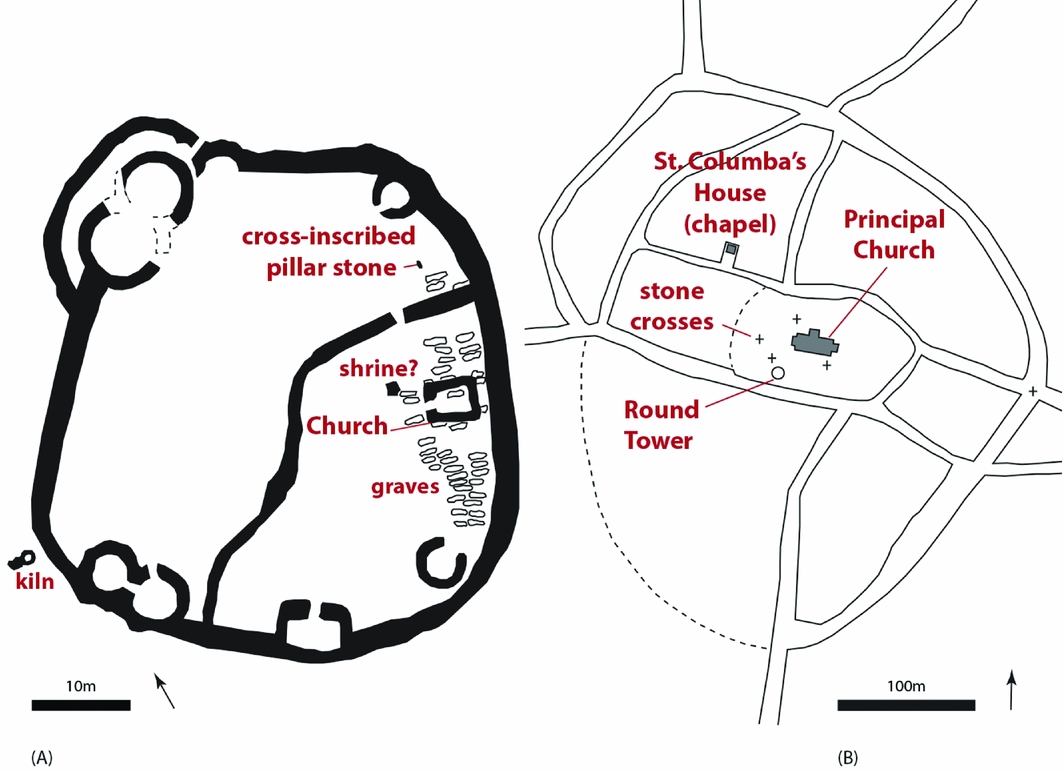
This ubiquity of concentric settlement organisation belied considerable functional diversity, including local, episcopal and monastic settlements (Figure 1). Excavations at Irish ecclesiastical settlements indicate various levels of investment in agriculture, craft, monastic practice, lay worship and pilgrimage (O'Sullivan et al. Reference O'Sullivan, McCormick, Kerr and Harney2013; Corlett & Potterton Reference Corlett and Potterton2014). Laypeople often dwelt, worked and worshipped at ecclesiastical settlements alongside men and women in religious orders (Etchingham Reference Etchingham1999: 363–45). Combining these insights with archaeological theories of ritual, emerging research explores how built settings structured the experiences, interactions and economic relations between monks and lay groups (Ó Carragáin Reference Ó Carragáin2009, Reference Ó Carragáin2010, Reference Ó Carragáin2013).
Concentric plans at (A) Reask, County Kerry, a small church settlement that probably served a local kin-group (after Ó Carragáin Reference Ó Carragáin2010: 226) and (B) Kells, County Meath, a major monastic-episcopal centre (after Ó Carragáin Reference Ó Carragáin2010: 264).

Sacred space and social diversity
Recent archaeological studies frame ritual as an embodied experience, fundamentally structured by its material settings and vital to the production of cultural, political and institutional ideologies (Insoll Reference Insoll2004; Fogelin Reference Fogelin2007; Rowan Reference Rowan2012). The built environments of ritual afford certain experiences that influence how people act to sustain or transform their social relations (Sewel Jr Reference Sewell2005; Beck & Brown Reference Beck, Brown and Rowan2012). This framework especially suits the analysis of pilgrimage forms, in which actors from different areas and status backgrounds partake in prescribed movements across landscapes. While the juxtaposition of different actors joined in pilgrimage can promote temporary sentiments of equality, the spatial segregation of actors can alternatively re-inscribe prevailing social divisions (Turner & Turner Reference Turner and Turner1978; Coleman & Elsner Reference Coleman and Elsner1995; Mack Reference Mack2004; Van Dyke Reference Van Dyke2007). How did the settings of early medieval ritual enable embodied experiences, interactions and the reproduction or transformation of social relations?
The extent of formalised pastoral care in early medieval Ireland remains uncertain. Yet contemporaneous legal texts indicate that laypeople who worshipped at ecclesiastical settlements were often tenant farmers who paid food-rents to ecclesiastical communities in return for participation in ritual and for burial on sacred ground (Etchingham Reference Etchingham1999: 363–454; Ó Carragáin Reference Ó Carragáin2014). An eighth-century collection of ecclesiastical law—Collectio Canonum Hibernensis—suggests how the concentric organisation of ecclesiastical landscapes and an ideology of sacred hierarchy could legitimate exchanges of resources for spiritual wellbeing. The text prescribes three concentric divisions at holy sites—the outermost sanctus (sacred), the intermediate sanctior (more sacred) and the innermost sanctissimus (most sacred). While only clerics could access the sanctissimus, laypeople, regardless of gender, and even those guilty of sexual sins could access the outer boundaries (Doherty Reference Doherty, Clarke and Simms1985: 59). Similarly, a seventh-century depiction of a church in Kildare imagines internal divisions separating men and women and clerical and lay worshippers—“people of varying status, rank, sex and local origin, with partitions placed between them [. . .] differing in status, but one in spirit” (Connolly & Picard Reference Connolly and Picard1987: 25–26). Although idealised, these texts indicate that ecclesiastical communities designed ritual infrastructure to accommodate social diversity by segregating different categories of worshippers. By regulating the access of laypeople, ritual performances could generate experiences of unity without challenging clerical claims to a privileged sacred status.
Island monasteries of Connemara
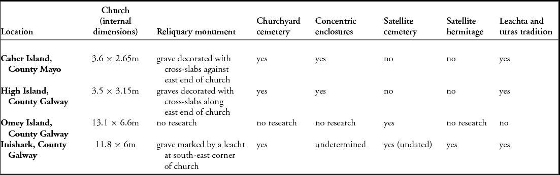
Despite the symbolic power of islands as desert retreats, monasteries on offshore islands collected food-rents from tenants on mainland estates and hosted seasonal pilgrimages (Ó Carragáin Reference Ó Carragáin and Carver2003: 141; Murray et al. Reference Murray, McCormick and Plunkett2004: 183; Bourke et al. Reference Bourke, Hayden and Lynch2011: 465). Island ecclesiastical settlements in Connemara, a region in western Ireland, accommodated different groups in various ritual traditions, materialised through enclosures, church dimensions, cemeteries and varied locations for prayer (Table 1).
Ritual infrastructure at four island settlements in Connemara.

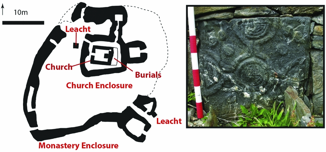
The well-preserved medieval landscapes of High Island (County Galway) and Caher Island (County Mayo) include concentric boundaries defined by walls and circuits of satellite stone platforms known as leachta (singular leacht). Leachta acted as prayer stations within processional circuits, or turas ‘journey’ rituals, in the post-medieval period (Herity Reference Herity1995: 106–107). Recent research confirms that leachta and their associated ritual practices developed in the context of early medieval pilgrimage liturgies (O'Sullivan & Ó Carragáin Reference O'Sullivan and Ó Carragáin2008: 316–17; Corlett Reference Corlett, Corlett and Potterton2014: 85–89). On both islands, graves marked with elaborate cross-slabs are located immediately adjacent to the east end of small churches set within concentric enclosure walls (Figure 2). On High Island, excavations revealed the burials of what are believed to be four adult males enshrined in a stone grave setting—probably former monks whose remains were venerated as relics (Scally Reference Scally2014: 309–11). The combination of turas traditions and concentric boundaries suggests that the small monastic communities occupying High and Caher Islands could tightly regulate the access of pilgrims to churches and reliquary monuments. Omey Island's early medieval landscape is less well preserved, but excavation of a coastal cemetery approximately 170m from the church yielded the remains of at least 134 children, women and men, ranging in date from the seventh to the thirteenth centuries (Scott Reference Scott2006: 31–33, 63). These results suggest that laypeople came to Omey over many centuries to worship and to bury their dead (Scott Reference Scott2006: 109–10). The burial patterns at Omey and High Islands reflect a broader trend amid ecclesiastical settlements: the corporeal relics of venerated monastic men—often placed in monumental settings—stood near the centre of ritual landscapes, while demographically mixed lay cemeteries were located in more peripheral settings (Ó Carragáin Reference Ó Carragáin2013: 28–29). Textual and archaeological evidence suggests that such lay cemeteries sometimes developed around the burial of a monastic figure whose presence consecrated the site (Fry Reference Fry1999: 163; O'Sullivan & Ó Carragáin Reference O'Sullivan and Ó Carragáin2008: 296).
Left) simplified plan (after Marshall & Rourke Reference Marshall and Rourke2000: 48) of the concentric enclosures of the central monastic complex on High Island; right) a cross-slab marking a grave along the east end of the church on High Island.

At each island in this regional overview, the configuration of ritual infrastructure would have cultivated different models of sacred hierarchy that framed the physical interactions and economic exchanges between monks and laypeople. Regulating the proximity of lay worshippers—in ritual and in death—to sacred places and corporeal relics of holy men established the superior sanctity of clerics. New evidence from Inishark reveals how juxtaposing the devotions of lay-pilgrims and penitential ascetics could highlight sacred affinity, as well as hierarchy.
Ritual infrastructure on Inishark
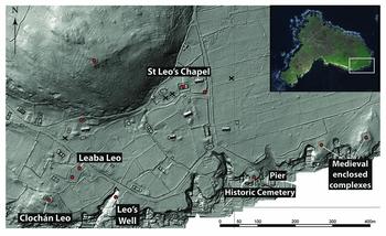
Remnants of Inishark's early medieval monastic settlement persist amid a landscape dominated by houses and field walls of a post-1800 village (Gibbons & Higgins Reference Gibbons and Higgins1993; Kuijt et al. Reference Kuijt, Lash, Gibbons, Higgins, Goodale and O'Neill2010, Reference Kuijt, Lash, Shakour, Burke and Donaruma2015). During the nineteenth century, islanders visited Inishark's early medieval landmarks as part of a turas circuit on St Leo's Day (11 April) (Browne Reference Browne1893; MacLoughlin Reference MacLoughlin1942). Guided by early Ordnance Survey maps, antiquarian accounts, oral history and LiDAR imagery, the Cultural Landscapes of the Irish Coast's (CLIC) survey has identified 15 features that islanders used as ritual monuments in the historic village settlement (c. AD 1750–1960) or in previous centuries (Figure 3).
Ritual infrastructure plotted on LiDAR image of Inishark. Circles mark extant monuments; Xs mark the locations of monuments recorded in the 1838 Ordnance Survey of Ireland and documented in 1942 (inset map from Google Earth).

The earliest phases of St Leo's Chapel date to between the eleventh and thirteenth centuries. Later renovations preserved the dimensions (11.85 × 6m, internal) of its medieval form, which could have served a large congregation of monks and laypeople. Eight burials exposed during test excavations along the eastern, western and southern walls of the church may represent only a small portion of an early medieval cemetery (Kuijt et al. Reference Kuijt, Lash, Gibbons, Higgins, Goodale and O'Neill2010: 60). A small leacht capped a grave at the south-east corner of the church, but there is no evidence of any associated carved or incised cross-slabs. Later settlement has obscured any enclosing features that may originally have surrounded the church and cemetery.
The 1838 Ordnance Survey map and folklore collected in April 1942 indicate that a number of small stone leachta once stood within the village (MacLoughlin Reference MacLoughlin1942). The best preserved of these is Leaba Leo, a sub-rectangular platform (1 × 1.5m) located approximately 300m from the church. Farthest from the church and set along the coast are three stone enclosures, including the Clochán Leo Complex and two sub-rectangular enclosures east of the pier (Figure 3). Nineteenth-century worshippers slept within Clochán Leo as the final stage of the pilgrimage circuit (Browne Reference Browne1893: 359). Although the Clochán Leo Complex is positioned on the shoreline distant from St Leo's Chapel, excavations indicate that the site represented an important focus of early medieval ritual on the island.
The Clochán Leo Complex
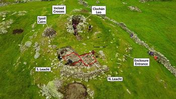
The complex is defined by a curvilinear stone enclosure (17.7m north–south × 16.5m east–west, external) on a prominent knoll along the south-east coast of Inishark. A 0.5m-wide gap in the 0.75m-thick enclosure wall provided an entrance from the north-east. To the west within the enclosure is Clochán Leo, a ruined stone structure (clochán) standing approximately 1.5m above modern ground level (Figure 4). Appearing circular externally, the clochán's internal dimensions (1.9m north–south × 2.6m east–west) are sub-rectangular with an eastern entrance. The structure formerly had a corbelled stone roof.
Clochán Leo Complex under excavation (2017).

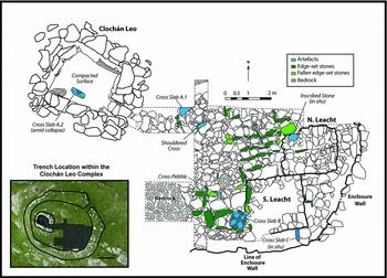
To understand better the character and origins of the complex, the CLIC project excavated approximately 35m² extending from the interior of the clochán to the eastern enclosure wall (Figures 5–7). Within the clochán, archaeologists removed 0.7m of post-medieval deposits, including collapse, informal pavements and ash scatters of temporary hearths. Associated ceramic and glass finds indicate that people periodically re-visited the site between the seventeenth and twentieth centuries to consume alcohol, picnic and camp, probably during St Leo's Day celebrations. The western wall of the clochán included three large stones incised with simple crosses of uncertain date. The variability of design and tooling of the crosses could reflect multiple events—possibly separated by centuries—rather than a single initiative. The probable early medieval floor within the clochán consisted of a hardened surface of packed soil. Considering its small size and eastern entrance, the clochán could have acted as an oratory for a small congregation of worshippers, or as a hermitage for an ascetic or penitent in the early medieval period.
Composite plan of excavations (2012, 2017) within the Clochán Leo Complex, showing the developed Phase II complex.

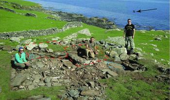
View of the complex under excavation (2012) with most of the quartz pebbles removed. The inscribed stone and cross-slab B are outlined in blue and the extent of the leachta in red.

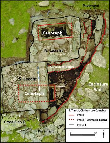
Phasing of cenotaphs and leachta at the Clochán Leo Complex (2017).

Finely fitted flagstones led from the threshold of the clochán into a wider pavement area strewn with quartz pebbles and divided by alignments of edge-set stones (Figure 6). At the eastern end of the trench stood two 0.3m-high leachta platforms (Figure 7). The northern leacht encased a rectangular chamber (0.8m north–south × 1.9m east–west) defined by edge-set stones and filled with a 0.5m-deep deposit of beach gravel intermixed with quartz pebbles and periwinkle shells. The southern leacht (only partially excavated) overlaid a similar rectangular chamber (0.8m north–south), which was also filled with beach gravel, quartz and shell to a depth of 0.35m. Although the chamber dimensions and orientations were suggestive of graves, their gravel fills lacked any skeletal material. A recent assessment of hagiographic and archaeological evidence suggests that some leachta represented cenotaphs or symbolic tombs for saints buried elsewhere (Ó Carragáin Reference Ó Carragáin, O'Donovan, Ghabhann and Narkiewicz2017). At the Clochán Leo Complex, early medieval builders seemingly constructed the leachta as monumental commemorations for cenotaphs.
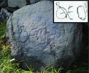
Stone artefacts help to define the phasing of the complex. An inscribed stone (approximately 0.38 × 0.3 × 70mm) capped the gravel chamber encased in the northern leacht (Figure 8). Notably, the stone lay with the inscription facedown. The faint text appears to read beo (or possibly ben) in Insular script, a form of writing dating to the seventh to ninth centuries (Duncan Reference Duncan, Flechner and Meeder2016: 217–19). Most inscriptions from ecclesiastical settlements are commemorative stones from mortuary contexts that implore the reader to pray for a named individual (Higgins Reference Higgins1987: 136; Okasha & Forsyth Reference Okasha and Forsyth2001). The inscription could represent a discarded attempt at such a formula, or simply read beo, meaning ‘I bless’ in Latin or ‘life’ and/or ‘alive’ in Old Irish. Speculatively, the inscription may represent a consecration stone (‘I bless’) laid at the completion of the cenotaph, or be a reference to resurrection theology (‘alive’). Whatever the case, the inscription could suggest a construction date before the tenth century for the northern cenotaph.
The ‘beo’ stone, in Insular script, found facedown atop the northern cenotaph.

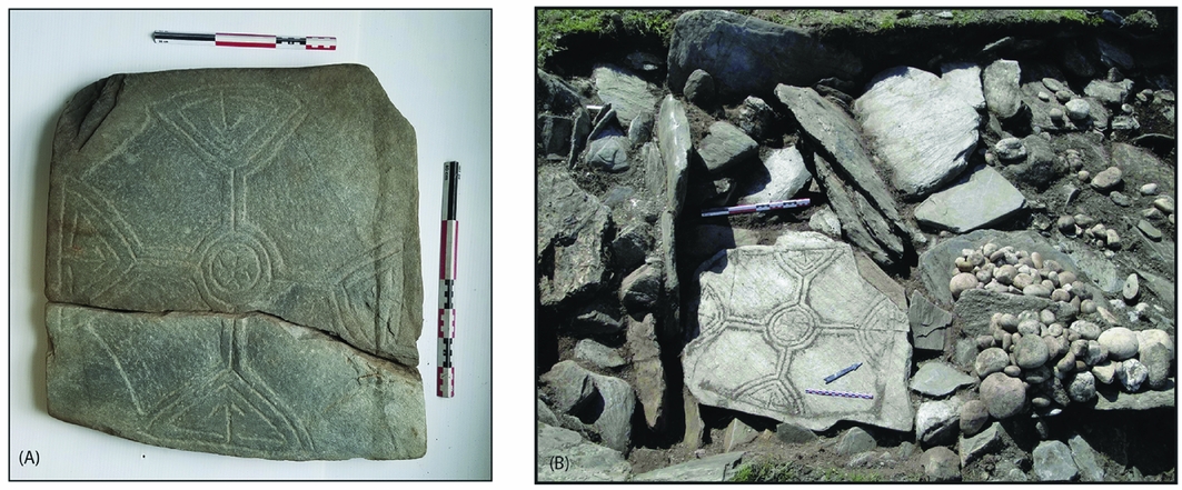
Incised cross-slabs represent a later phase, probably corresponding with the construction of the leachta and pavement. Cross-slab A was found ex situ in two fragments, one outside the clochán entrance and another amid a layer of collapsed stone within the clochán itself (A1 & A2 in Figure 5). A similar but more intact cross-slab (cross-slab B) rested on the pavement where it appeared to have fallen from atop the collapsed southern leacht and broken in situ (Figure 9). Folklore and photography collected on Inishark in the 1940s attests to the existence there of at least one other cross-slab, now missing, bearing a similar design (Machoughlin Reference MacLoughlin1942; Higgns & Gibbons Reference Higgins, Gibbons, Galway and Higgins2017). Such ‘expansional’ cross designs are found on slabs across the country, including at Clonmacnoise in County Offlay (Swift Reference Swift and King2003: 118). The nearest comparable pieces come from High Island, where two such slabs covered the graves of individuals dated to between the late ninth and early eleventh centuries (Maddern Reference Maddern and Scally2014: 194–96; Scally Reference Scally2014: 228–30). Cross-slabs A and B probably belong to the same period. Found in situ, cross-slab C bears a faint double-lined Latin cross, and is stratigraphically contemporaneous with the leachta and pavement. Thus, the commissioning of the cross-slabs and the addition of the pavement and leachta probably date to between AD 900 and 1020.
A) Cross-slab A, found ex situ in two fragments; and B) cross-slab B in its findspot beside a heap of quartz excavated from the pavement east of Clochán Leo.

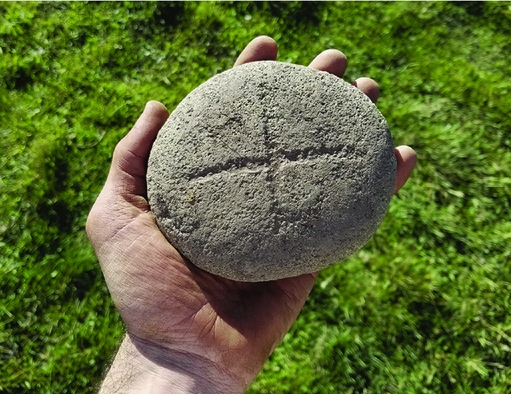
This elaboration of ritual infrastructure at the turn of the first millennium AD developed the complex as a pilgrimage shrine focused on the twin leachta. Six hundred and eighty-eight water-rolled quartz pebbles, excavated from atop the pavement (with many more embedded between flagstones), may represent direct evidence of pilgrims’ journeys (Figure 9). The densest concentration of pebbles was clustered near the eastern end of the trench, suggesting that their deposition focused on the leachta. Several excavations from across northern Britain and Ireland demonstrate that people deposited quartz stones in graves and on pilgrimage monuments during the early medieval period (Hill Reference Hill1997: 472–43; Marshall & Walsh Reference Marshall and Walsh2005: 87–89; O'Sullivan & Ó Carragáin Reference O'Sullivan and Ó Carragáin2008: 270, 320). Medieval hagiography references both the healing capacity of white stones and the manipulation of sacred stones to swear oaths and enact curses (Anderson & Anderson Reference Anderson and Anderson1991: 398–405; Maddern Reference Maddern and Scally2014: 198). These early medieval practices influenced later turas traditions, in which pilgrims marked their journeys to shrines by depositing stones or rotating distinctively shaped or decorated ‘cursing stones’ in order to swear an oath or enact a blessing or curse (Higgins Reference Higgins1987: 18–24; O'Sullivan & Ó Carragáin Reference O'Sullivan and Ó Carragáin2008: 335–41; Corlett Reference Corlett, Corlett and Potterton2014: 84–85). The complex produced one possible earlymedieval cursing stone—a cross-inscribed granite pebble found on the pavement (Figure 10). Although we can only speculate that quartz pebbles represent the offerings of pilgrims, these finds indicate that early medieval pilgrims sought spiritual rewards by manipulating stones at sacred places.
Overall, the Clochán Leo Complex contains all of the infrastructural components of a pilgrimage shrine developed between the ninth and eleventh centuries. Perhaps understood as symbolic graves, the twin leachta functioned as foci of veneration, including possible votive deposition, cursing and oath-taking. Notably, the complex integrates pilgrimage activity with a small oratory or hermitage. Early medieval annalistic references to reiclés appear to denote subsidiary complexes at ecclesiastical settlements that served such a dual function (MacDonald Reference MacDonald1999). Similarly, at the early medieval monastery on Inishmurray (County Sligo), a coastal enclosed complex known as Trahanareear combined an ascetic cell with a pavement and two leachta (O'Sullivan & Ó Carragáin Reference O'Sullivan and Ó Carragáin2008: 216–39). Clochán Leo seems to have functioned as both a marginal hermitage and a primary focus of pilgrimage on Inishark.
The cross-incised granite beach pebble excavated from the Clochán Leo Complex.

Ritual experiences at the Clochán Leo Complex
How did the Clochán Leo Complex frame experiences of monastic and lay worshippers? Based on analogy with comparable settlements, monks and pilgrims probably visited Clochán Leo as part of penitential liturgies that included a circuit of leachta and other ritual monuments (Ó Carragáin Reference Ó Carragáin2013). The complex's enclosure marked visitors’ transition to an especially sacred space and allowed monks to restrict access as they wished. The size, orientation and marginal setting of Clochán Leo suggest that it represented a hermitage used for the personal prayer of an ascetic. Influenced by depictions of Early Christian hermits, early medieval texts associate anchorites and recluses with caves and stone-dwellings (Manning Reference Manning, Conduit and Corlett2005). Enclosing an ascetic within a privileged sacred space, the cave-like clochán facilitated imitation and observation of a revered model of devotion. The eastern entrance would have allowed an ascetic to look outwards towards the leachta, while visiting pilgrims might have looked inwards at an ascetic.
Part of a seascape of monasteries with shared patterns of art and architecture, ritual infrastructure at Clochán Leo situated worshippers within multiple geographic scales of ecclesiastical affiliation and authority. To well-travelled pilgrims and monks, the ‘expansional’ cross-slabs evoked a common iconographic repertoire. A recent survey using portable XRF analysis of stone crosses in Connemara suggests that the exchange of lithic material and cross designs reflect interactions between island monasteries (Goodale et al. Reference Goodale, Bassett, Bailey, Lash and Kuijt2017). The monasteries on High Island and Inishark, although invested in different saint cults, probably shared a tradition of artisanship or access to the same group of travelling sculptors. Intriguingly, nineteenth-century celebrations of Leo's Day on Inishark correspond in date (11 April) with the medieval feast day of Pope Leo the Great (died AD 461). Although speculative, a symbolic tomb in honour of St Leo the Great on Inishark is entirely consistent with allusions to the sacred topography of Rome in the layout and dedications of Irish ecclesiastical landscapes (Ó Carragáin Reference Ó Carragáin2010: 60–65). Offering pilgrims the intercession of an illustrious pope, a cenotaph dedicated to Leo would have affirmed papal power, even to the western edge of Christendom.
For lay worshippers, seasonal pilgrimage represented a rare opportunity to access sacred space and to ensure their own spiritual wellbeing. Pebbles played an integral role in this endeavour. Pilgrims may have used the granite cross-pebble to make oaths, blessings or curses. Angular quartz bands occur in the bedrock of Inishark, but monks or pilgrims had to seek out and gather the quartz pebbles from beaches, where the churning seas, often associated with divine agency (Muhr Reference Muhr1999), had worn them smooth. If pilgrims brought the pebbles as offerings, the excavated total would reflect nearly 700 journeys during the early medieval period. Biblical precedent and hagiographic tradition associate whiteness with spiritual cleanliness, monastic living and healing (Stancliffe Reference Stancliffe, Whitelock, McKitterick and Dumville1982: 40; Thompson Reference Thompson, Lucy and Reynolds2002: 240). Hence, early medieval Christians may have perceived smoothed white stones as embodiments of divine power and vectors of sanctity that spiritually cleansed their handlers.
Spatial order and sacred affinity
As discussed above, ecclesiastical landscapes regulated the interactions of laypeople with monks and sacred loci to promote ideologies of sacred hierarchy. The landscape setting of the Clochán Leo Complex and its distinctive combination of features suggest that ritual practice could also highlight the devotional affinity of worshippers.
Unlike nearby island monasteries, the most elaborate foci of pilgrimage on Inishark were not the relics of monks set within concentric boundaries, but cenotaphs, which were set within a peripheral complex possibly occupied by a living ascetic. Peregrinatio (‘pilgrimage’) has many resonances in early Irish texts, implying penitential exile that could be embodied by both travel or hermetical isolation and stability (Hughes Reference Hughes1960: 148; Johnston Reference Johnston, Flechner and Meeder2016: 40). Hence, pilgrims granted access to the complex participated temporarily in an idealised form of worship embodied by the ascetic devotee. Instead of reiterating sacred hierarchy by segregation and exclusion, ritual practices at the Clochán Leo Complex could highlight the similarity between lay-pilgrimage and more permanent ascetic lifestyles as forms of peregrinatio. The possibility that pilgrims contributed to the formation of the complex by depositing quartz pebbles would have enhanced this sense of shared participation in ascetic devotion. Allowing physical access to the enclosure may have been a useful strategy for attracting pilgrims and maintaining reciprocal relations with affiliated lay tenants. Crucially, monks could selectively restrict access to the complex and the occult objects curated within. Monks thereby maintained a privileged position as mediators of salvation, which could legitimate claims to the economic support of lay tenants and pilgrims. This tension between hierarchy and affinity resonates with cross-cultural analyses of pilgrimage, and suggests how temporary experiences of equality in ritual can often sustain more durable, hierarchical social relations (Eade & Sallnow Reference Eade and Sallnow1991; Coleman Reference Coleman2002).
Conclusion
Excavation of the Clochán Leo Complex on Inishark revealed a hermitage and pilgrimage shrine dating from the ninth to eleventh centuries AD. Proximity to a practising ascetic and cenotaphs probably provided the major attraction for pilgrims. The material settings of the complex situated worshippers within a regional and international context of ecclesiastical authority. Ritual experiences enacted ideologies of sacred hierarchy and affinity that reinforced relations between monks and laypeople. Along the coast of Connemara, as within Ireland as a whole, early medieval churchmen constructed ritual landscapes that supported their communities’ practical and ideological demands by materialising models of sacred space in nuanced ways. Despite the apparent contrast between Irish monastic landscapes and continental claustral monasteries, both architectural styles acted simultaneously as ritual and political infrastructure that strategically regulated worshippers’ experiences in order to promote the monks’ spiritual and economic privilege. In early medieval Ireland, as elsewhere, recognising diversity among participants in ritual means also considering how the infrastructure of seclusion, exclusion and integration worked to create, sustain or obscure that diversity.
Acknowledgements
Profound thanks are due to the people of Inishark, Inishbofin, Inishturk and surrounding points on the mainland for the insight, generosity and hospitality that they have offered to the CLIC project. Special thanks go to the staff of the Doonmore Hotel, Inishbofin, and the crew of the Inishbofin Ferry. Research would not have been possible without the help of the CLIC field crews, especially Linda Martellaro. We also thank Terry O'Hagan and Franc Myles for their experience and guidance in the field and during the drafting of this paper, and the peer reviewers for their insightful comments and critiques. Any remaining errors are our own. Funding for this research has been provided by the John Tynan family, the Institute for Scholarship in the Liberal Arts, University of Notre Dame, and the Office of Sponsored Research, University of Notre Dame. Additional funding has been provided by the National Science Foundation Graduate Research Fellowship 1000135637 and Doctoral Dissertation Improvement Grant Award 1630141.