Untangling site occupation histories is key to many archaeological investigations (e.g., Binford Reference Binford1982; Holdaway and Wandsnider Reference Holdaway and Wandsnider2008; Schiffer Reference Schiffer1983, Reference Cook1987). Particularly vexing are attempts to sequence site histories in single-component occupations that often spanned as little as a few decades in settings where radiocarbon dating provides most of the temporal control, since radiocarbon dating inadequately parses events such as the construction sequence for houses that might be spaced only a few years apart. This situation is not fully remedied with Bayesian modeling and is often compounded at sites lacking in pronounced vertical stratigraphy and the lack of stylistic changes in artifacts that could provide useful data for seriations. Although it is possible to use radiocarbon dates, architectural evidence for rebuilding, and the associations of diagnostic artifacts to determine a village's occupation sequence, as at the SunWatch site (Cook Reference Cook2007, Reference Cook2008; Krus et al. Reference Krus, Cook and Hamilton2015), such is only possible with a site that has been extensively excavated, in the case of SunWatch over nearly two decades of field research (Heilman et al. Reference Heilman, Lileas and Turnbow1988; see also Cook Reference Cook2008). How can we examine other site formation histories without excavating most of a given settlement? In this report, we utilize a method for sequencing houses detected with geophysical prospection at the Guard site (12D29), a village located in southeastern Indiana (Figure 1). We excavated narrow trenches (1 m wide) or small test units (50 × 50 cm) in house anomalies and analyzed materials to determine the site occupation history via relative artifact frequencies and fluoride analysis of animal bone. We then compared the Guard village formation sequence with that of the SunWatch site, which is located along the same river as the Guard site, shares many cultural characteristics, and is the only other Fort Ancient village where many houses have been clearly defined (Cook Reference Cook2017).
Location of study sites in the Fort Ancient region of the Middle Ohio River valley (Fort Ancient boundary based on Cook 2017:Figure 2.2).

Our results support the conclusion that the sequences for Guard and SunWatch are very similar. At both sites, occupations commenced with larger houses in what became multihouse households. Houses were first added to an inner ring in each village, with the final houses built in the outermost ring. At Guard, relative artifact frequencies are negatively correlated with fluoride levels and together form relatively discrete categories, likely reflecting different stages of formation and function. Generally, houses constructed first have the most fluoride and the lowest artifact frequencies, and houses constructed last have the least amount of fluoride and the highest artifact frequencies. Fluoride analysis also revealed that some houses have older bones in levels above those with younger ones, the reverse of what would be expected of accretional refuse deposits, which were also present. The general interpretation of this pattern is that some house basins were filled with surrounding midden deposits at the time of village abandonment, while others were used as trash receptacles during occupation of the site.
A Known and Unknown Case of Household and Village Formation
Here we compare a known (SunWatch [33MY57]) and unknown (Guard [12D29]) case of village growth, two sites that are part of the Fort Ancient culture (ca. AD 1000–1650), a Mississippian manifestation located along a portion of the Middle Ohio River and its tributaries (Cook Reference Cook2017). The SunWatch site is located along the Great Miami River, just south of Dayton, Ohio, and is the only Fort Ancient village where the sequencing of house construction is known (Cook Reference Cook2007; Krus et al. Reference Krus, Cook and Hamilton2015). In this case, the village commenced as a smaller circular pattern of widely spaced houses, with the intervening gaps filling in with time along with the addition of another ring of structures in some portions of the site (Figure 2a). This pattern of village growth has been interpreted to relate to the growth cycle of corporate households in the north and south parts of the village and the development of a ritual/political center defined by the solstice alignments that bracket the western portion of the site (Cook Reference Cook2008). At the mouth of the Great Miami River (86 km [53 mi] downstream from SunWatch), the senior author is directing a long-term investigation focused on the Guard site. A magnetic gradiometry survey of this site produced an unusually clear house pattern, with 16 well-defined structures (Figure 2b; Cook et al. Reference Cook, Comstock, Martin, Burks, Church and French2015).Footnote 1 The overall similarity in village structure for these two circular village sites is further enhanced by consideration of house size, with the largest houses concentrated in the western portion of each site, which is demarcated by key solar alignments (Figure 3).Footnote 2
(a) Location of key solar alignments and the construction sequence previously established for the SunWatch site (see Cook Reference Cook2007, 2008, for more details) and (b) structures identified at the Guard site as a result of magnetic gradiometry survey (see Cook 2017; Cook et al. Reference Cook, Comstock, Martin, Burks, Church and French2015).

Comparison of house sizes at the (a) SunWatch and (b) Guard sites.

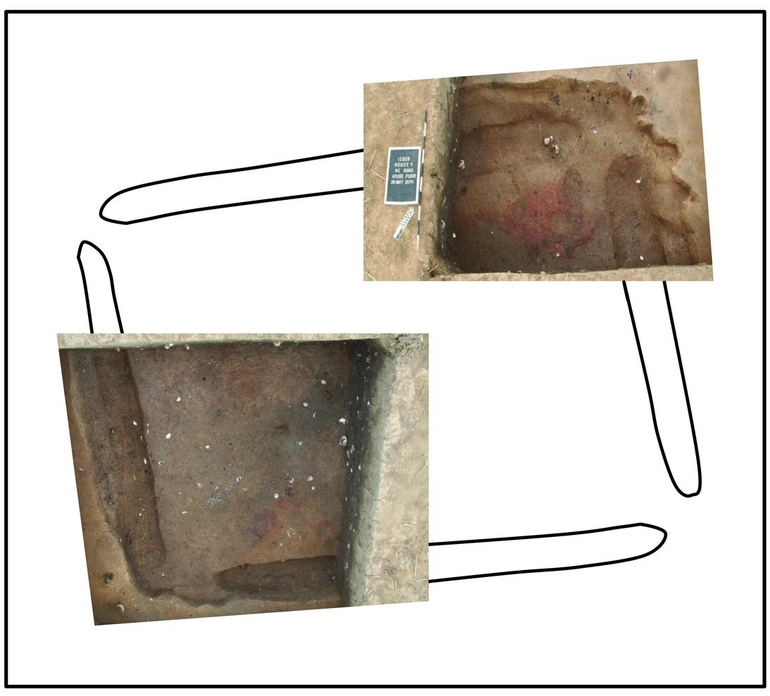
Photographs of two house corners and the projected extent of House 4 at the Guard site. Note that the scale is 1 m in length.

Excavations completed thus far at Guard have focused on testing a variety of magnetic anomalies within the site. We began by excavating narrow (1 m wide) trenches through Houses 1, 2, and 3 (Cook et al. Reference Cook, Comstock, Martin, Burks, Church and French2015), approximately one-half of House 4 (two 3 × 3 m blocks over opposing corners; Figure 4), and small units (50 × 50 cm) in other clearly defined structures (Cook et al. Reference Cook, Schulenburg and Comstock2016), as well as portions of a variety of pit and hearth features throughout the plaza (Cook et al. Reference Cook, Comstock, Martin, Burks, Church and French2015; Cook et al. Reference Cook, Comstock and Schulenburg2018). Accelerator mass spectrometry radiocarbon dates on multiple media (bone, carbonized wood, and a variety of carbonized annuals) place the site among the earliest in the region (Cook Reference Cook2017; Cook et al. Reference Cook, Comstock, Martin, Burks, Church and French2015), predating but overlapping with the SunWatch site (Supplemental Figure 1). Of particular interest for the present study are the five radiocarbon dates associated with architectural elements and contexts from known house structures at Guard, which are consistent with the dating of the site as a whole (see Cook et al. Reference Cook, Comstock, Martin, Burks, Church and French2015). These dates are associated with four different houses in the village pattern. Calibrated two-sigma date ranges overlap considerably for all four houses from the early eleventh to thirteenth centuries AD, with one statistically significant outlier being a fourteenth-century date from House 1. This date is from a large intrusive ritual post in this structure. House 1 also provides the only clear evidence thus far for vertical stratigraphy on the living surfaces indicative of rebuilding. Excavation of House 3 revealed more evidence for horizontal stratigraphy (i.e., feature overlap and higher posthole concentrations), suggestive of reuse/rebuilding as well. In contrast, Houses 2 and 4 are much clearer patterns that seem to reflect single construction episodes or at least less intensively remodeled structures. As we expected from consideration of the SunWatch pattern, where there were more rebuilding episodes for the inner ring of houses than the outer ring of houses, Guard Houses 1 and 3 are in the inner ring of houses, and Houses 2 and 4 are in the outer ring of houses. With the SunWatch model in mind, and on the basis of the limited data from radiocarbon dating and excavations at Guard, we formulated two hypotheses for the present study: (1) Guard's inner ring of houses was established first, and then, as the outer ring of houses was added, the inner ring was remodeled; and (2) larger houses were built first, initiating household growth cycles throughout the village.
A Method for Sequencing the Unknown Case
Our focus here is on exploring a relatively quick, simple, and inexpensive method of sequencing a village household construction sequence, focused on artifact frequencies and the fluoride contents of animal bone. Excavation methods were focused on small test units (50 × 50 cm) in central portions of each house in areas without intramural magnetic anomalies (i.e., not over potential hearths or pits), as the goal was to obtain samples from fill and floor contexts. Standard procedures were followed for the excavation of these test units. As natural levels could not be consistently discerned given the homogeneity of most of the deposits, all levels were arbitrarily defined (10 cm) and were screened in their entirety with 0.64 cm (1/4-inch) hardware cloth, with the exception of the plow zone, which was consistently excavated at 30 cm and from which a 25% sample was screened. For the four houses that were excavated previously with larger extents (Houses 1–4), a 1 × 1 m unit was selected from the larger block to represent a comparable unit. The artifact totals from this unit were divided by four to be comparable with the 50 × 50 cm units. Also, selection of the 1 × 1 m units in Houses 1–4 adhered to the same criteria used for positioning of the smaller ones (i.e., in central portions of the houses in areas devoid of magnetic anomalies). Since all units were the same volume, artifact frequencies represent a standard measure (i.e., there would be no relative distinction if we calculated densities).
Fluoride dating is based on the simple principle that buried bones pick up fluoride ions from soil moisture over time so that older bones contain more fluoride (Oakley Reference Oakley1951). Although simple in principle, fluoride dating can be difficult to implement in practice. It is well known that fluoride dating produces relative chronologies because fluoride concentrations in bone can vary significantly based on the local soil and groundwater chemistry. Variations in exposure to soil moisture can also be significant. When different depositional contexts produce marked variations in exposure to soil moisture, results can be unreliable or even inverted (Guerrero et al. Reference Guerrero, Schurr, Kuijt, Anfruns and Molist2011; Wrobel Reference Wrobel2007), and there is often very little information available about variations in soil chemistry or moisture levels that might affect fluoride uptake even within a single site. It is therefore necessary to evaluate the applicability of fluoride dating in each specific case. In general, fluoride dating seems to work best at sites with fine-grained soils that show relatively little or no variation in soil type or elevation across the site.
The geologic and sedimentary setting of the Guard site seems well suited for fluoride dating as the site is located on a floodplain that is relatively flat, with gradual changes in elevation of less than a meter between 144.2 and 144.8 m (473–475 ft) asl. There is a single soil type, Huntington silt loam, a deep floodplain soil with a neutral pH (Nickell Reference Nickell1981). The bones that were analyzed came from depths of 40–80 cmbs, with the majority of samples coming from depths of 60–80 cmbs in house basins that would have incorporated soil from the Ap, A12, and B21 horizons (Nickell Reference Nickell1981:73), all of which are composed of neutral silt loam with no abrupt stratigraphic changes in soil texture. Given the consistency in elevation and soil composition, it seems unlikely that variations in the local hydrology or soil chemistry of individual houses would produce the observed patterns.
Bones selected for fluoride analysis from Guard were from similarly sized mammals and were part of the same types of skeletal elements (in this case, long-bone fragments, probably from white-tailed deer [Odocoileus virginianus]). This is an important selection process for fluoride dating, as different bones absorb fluoride at different rates (Schurr and Gregory Reference Schurr and Gregory2002).
Fluoride content was determined by ion-selective electrode (Schurr Reference Schurr1989). Bone fragments were first washed manually with deionized water using a nylon brush to remove any adhering soil. The fragments were then ultrasonically cleaned in deionized water for 30 minutes and dried in an oven for 48 hours at 70°C. The dried bone was ground into a fine powder with an agate mortar and pestle. Using an analytical balance, samples of bone powder that weighed between 4.5 and 5.5 mg were placed in small, disposable plastic cups. The samples were dissolved in a solution of 500 μl of 0.5 M perchloric acid, 1,000 μl of deionized water, and 1,000 μl of TISAB II buffer. The potential in millivolts was recorded when the electrode had been immersed in the solution for two minutes. Before each set of measurements, the electrode was calibrated with standard fluoride solutions (in place of the deionized water) that bracketed the range of concentrations exhibited by the samples. The fluoride activity of the solution was determined using a calibration curve prepared with the standard fluoride solutions. Three replicate measurements were taken for each sample.
Results
Our first consideration was the general range of fluoride levels and artifact frequencies for each house (Table 1; Supplemental Table 1). Materials from the deepest contexts are more likely associated directly with activities that took place within a specific house (i.e., primary refuse). Here, whenever possible, we consider materials within 20 cm of the floor to be most closely associated with primary uses of that structure (similar to Diehl Reference Diehl1998:620). Primary refuse artifact assemblages are rare in houses in villages that were intentionally abandoned (Brooks Reference Brooks, Cameron and Tomka1993; Cameron Reference Cameron1991; Diehl Reference Diehl1998; see also Schiffer Reference Schiffer1983, Reference Cook1987), which we interpret to be the case at Guard (Cook et al. Reference Cook, Comstock, Martin, Burks, Church and French2015). However, it was reasoned that small fragments such as animal bones could well have been incorporated into house floors during primary use. Bones sampled in lower levels at Guard that had higher fluoride concentrations (i.e., older bones) are generally from the inner ring of houses, and those with lower fluoride concentrations (i.e., newer bones) are mainly from the outer ring of houses. Furthermore, findings indicate that the village began with the construction of houses on or near solstice alignments, which were major ritual axes that would likely have been particularly important to this early farming village (Cook Reference Cook2008, Reference Cook2017). The next phase of construction in the village was to establish houses roughly in each major household group in the village, which then grew laterally and then outward into a new ring in the village (Figure 5). As has been found elsewhere in relation to household cycles (e.g., Wilk Reference Wilk1983), these initial house sizes (founders/lineage heads) are larger than those subsequently built in a given household (Figure 3).
Average Bone Fluoride Content per House at the Guard Site by Level.

a Burned level.
Maps of the Guard site showing (a) variation in relative artifact frequencies and (b) the deepest fluoride levels tested for the houses, along with indications of different fill sequences (accretional vs. reversed). Note that each arrow represents one multihouse household construction sequence.

There are two scenarios regarding fluoride levels with respect to vertical stratigraphy at Guard. One is that the shallower levels are younger than deeper ones, which is expected if there was a gradual accumulation of refuse in an abandoned house basin (Cameron Reference Cameron1991; Sullivan Reference Sullivan2008). Fluoride levels in Houses 3, 5, 6, 8, and 14 are consistent with a gradual accumulation scenario. The other vertical stratigraphy scenario observed at Guard is that the shallower levels are older than the deeper ones; such reversed strata are expected when a house basin was filled in with older trash. Houses 1, 2, 4, 7, 10, 11, and 12 are consistent with this scenario. There are two clear spatial patterns. First, houses in the western part of the site (i.e., on or between solar alignments) only contain reversed stratigraphies. We interpret this to be related to a more ritualized function (i.e., they were not used for the gradual accumulation of trash). Second, Phase 4 is the only time when there is a notable distinction between these fill types, with a marked rise in the incidence of reversed stratigraphies (Figure 6). This pattern is clearest in the northern portion of the site. We interpret this to mean that those houses built toward the end of the site's use, and presumably in use at the time of site abandonment, were not present to serve as trash receptacles when the village was occupied.
Bar graph showing different fill types for each phase of house construction.

Houses with the most abundant artifacts are more common in the outer ring of structures, whereas houses with the fewest artifacts are mostly in the inner ring of structures (Figure 5). Three artifact classes (bone, chipped stone, and pottery) are responsible for most of this pattern (Supplemental Table 1). Limestone concentrations are similar in the inner and outer rings, with two exceptions, Houses 5 and 8, which have many more pieces of limestone than other houses. Burned earth also occurs in similar frequencies in inner and outer houses, with the exception of Houses 2 and 5, which contain roughly three times the amount as other houses. Sandstone (House 11), ground stone (House 5), and shale/slate (Houses 8 and 11) are only present in houses located in the outer ring. Fire-cracked rock occurs in roughly equal amounts in both outer and inner houses.
To further explore the formation histories of house fills, we considered the vertical patterning of burned earth and other artifacts. Houses 1, 2, 5, 8, 9, 10, 11, 15, and 16 contain burned earth that is vertically concentrated. Concentrations of burned earth were relatively deep in Houses 1, 2, 5, 7, 9, and 11 but relatively shallow in Houses 8, 10, 13, 15, and 16. However, other artifact concentrations were more evenly distributed vertically throughout Houses 1, 2, 4, 5, 9, and 11; but in Houses 15 and 16 artifacts and burned earth were similarly distributed. All but one (House 5) of the “deep burned earth” cases also contain reversed stratigraphy in terms of fluoride dates. We interpret this pattern to have resulted from house burning and infilling with older midden trash. It is also possible that house floor preparation or refurbishing used older village trash as fill for leveling uneven surfaces. To this point, we do know that the floor of House 4 (which has a reverse fluoride stratigraphy) was initially uneven and filled to make it level (Cook et al. Reference Cook, Schulenburg and Comstock2016). While houses located in the outer ring of the village are generally younger and have denser artifact concentrations, there is a further distinction for Houses 2, 4, 5, and 8. These houses contain disproportionately large amounts of shell. This pattern could have resulted from various events; one possibility is that they are the remains of feasts held in conjunction with the final backfilling of structures in the village, perhaps during the late summer/early fall, when mussels are most easily collected (Reidhead Reference Reidhead1981:141).
We statistically examined the relationship between relative artifact frequencies and fluoride levels at Guard, hypothesizing that fluoride concentrations and artifact frequencies would be strongly and significantly correlated. This was supported by the regression coefficient (r 2 = 0.62, p = 0.0003). The correlation is primarily driven by the three most common artifact types: bone, chipped stone, and pottery.
We further explored four fluoride/artifact groups: High Fluoride and Few Artifacts, Moderate Fluoride and Moderate Artifacts, Low Fluoride and Many Artifacts, and Low Fluoride and Moderate Artifacts (Figure 7). When we consider the spatial distribution of structures associated with these four artifact/fluoride groups, the construction sequence at Guard appears compellingly similar to the SunWatch case (Figure 8). The High Fluoride and Few Artifacts houses are interpreted as related to village founders keyed to the winter solstice alignment. The Moderate Fluoride and Moderate Artifacts category houses outside of the western area (n = 3), which is delineated by the two solstice alignments, are interpreted as being associated with founders of households, whereas the houses along the summer solstice alignment (n = 1) and inside the western area (n = 1) are more likely to have served a ritual function. The Low Fluoride and Many Artifacts category houses (n = 7) mainly appear to be more junior members of households whose structures are not as likely to have been rebuilt. The Low Fluoride and Moderate Artifacts houses (n = 2) are anomalous in terms of their slight deviation from the regular linear relationship (see Figure 7). They are also in a particular location in the village, along or near the equinox alignment (Figure 8). The relatively low occurrence of artifacts in these structures may also relate to a more specific ritual function.
Scatterplot of total artifact frequencies and deepest fluoride levels for all Guard site houses.

Comparison of house construction sequences at (a) the SunWatch site, based on radiocarbon dates, architectural evidence for rebuilding, and the associations of diagnostic artifacts (Cook Reference Cook2007, 2008), and (b) the Guard site, as established in this report. High-fluoride houses were built earliest, while low-fluoride houses were built most recently.

A Calcium Carbonate Concern
The house basins contained fragments of bone, limestone, and shell, all of which could interact with fluoride in groundwater and potentially affect results. Bone is composed of calcium hydroxyapatite (Ca5[PO4]3OH). Fluoride can be incorporated into the bone mineral when hydroxide ions (OH−) are displaced by fluoride ions (F−) that have the same charge and a similar atomic radius to OH− ions. The replacement first occurs at the surface, and F− ions migrate into the crystal (Fan et al. Reference Fan, Parker and Smith2003). Limestone and shell are composed of calcium carbonate (CaCO3) with minor impurities. The CaCO3 crystals do not contain spaces that can incorporate F− ions permanently into the crystal matrix. Fluoride is incorporated into limestone by surface adsorption only, which is temporary and reversible at low fluoride concentrations. While limestone has been used to filter fluoride from water, that is only effective when the limestone particle size is very small (particle sizes less than 1,500 μm) and when the aqueous fluoride concentration is relatively high (above 30 ppm; Labastida et al. Reference Labastida, Armienta, Beltrán, Caballero, Romero and Rosales2017) or even above 2,000 ppm (Fan et al. Reference Fan, Parker and Smith2003). The limestone fragments at Guard (see Supplemental Table 1) were much larger than those used to filter water, with a relatively low surface area, and are therefore not effective fluoride adsorbers. We did not test the fluoride content of groundwater from Guard, but tests of groundwater at the Angel site (12VG1), also in the Ohio Valley, produced results below the detection limit of the fluoride selective electrode (<0.01 ppm).
Linear regressions of bone fluoride content on the frequencies of bone, limestone, and shell counts (see Supplemental Table 1) of each level that contained the bones sampled for fluoride versus the average fluoride content for each level were conducted to test whether bone fluoride contents were correlated with the amounts of the co-deposited materials. No significant regression correlations were found for amounts per level (limestone: r 2 = 0.12, p = 0.18; bone: r 2 = 0.04, p = 0.46; shell: r 2 = 0.07, p = 0.34). It thus seems unlikely that co-deposited materials that could interact with fluoride are responsible for the differential fluoride contents of the bones from the house basins.
Conclusion
The goal of this study was to examine the utility of a low-impact and inexpensive field and laboratory method to sequence houses within a village made up of earthen architecture, comparing its fit with a known case in the same cultural tradition. Certainly, we did not expect the two site construction sequences to be identical; we hypothesized only that there should be some similarity, which is supported by our results. Fluoride dating and artifact frequencies allow us to describe a basic formation history for the Guard site. Based on fluoride results, the first structures to be built at the site included one on the summer solstice alignment and one on either side of the winter solstice alignment, followed by key founders of households who built relatively large structures spaced in all major parts of the village. As time passed, these households grew with the addition of new members, presumably the spouses of children and their offspring and/or others joining the kin group. The final stages of construction included the completion of the outermost ring of houses and a structure directly on the winter solstice alignment, which occurred at a time when many of the houses in the inner ring were being refurbished. It is also possible that there were shifts in annual occupation duration such that higher relative artifact frequencies reflect year-round instead of more seasonal occupations. We also proposed two possible processes of house abandonment: (1) that some houses were rapidly filled in with refuse at the time of final village abandonment and (2) that some houses were gradually filled with refuse after their use as residences ceased.
Our findings are important in establishing a sequence of house construction at the Guard site, which can serve as a guide for targeting future excavations, focusing on specific houses to examine particular aspects of household growth. This method is also very promising for sequencing other sites where houses have been located with geophysical prospecting and where there are adequate faunal assemblages and appropriate soils and topography for fluoride dating. This should prove of particular interest given the recent proliferation of geophysical surveys that have been able to map entire settlement plans (for a few Mississippian examples, see Bigman et al. Reference Bigman, King and Walker2011; Butler et al. Reference Butler, Berle Clay, Hargrave, Peterson, Schwegman, Schwegman and Welch2011; Peterson Reference Peterson, Pauketat and Alt2015). This approach could possibly be used to relatively quickly and feasibly sequence these and other sites.
Acknowledgments
The Sedler family and the Oxbow Conservancy graciously allowed us to conduct fieldwork on their properties that contain the Guard site. Amy Johnson and Rachel Sharkey at the Indiana Department of Natural Resources provided invaluable guidance and permissions regarding these investigations. Many Ohio State University students helped in the field and lab over the last several years, gathering the materials we have analyzed in this study. Lane Fargher assisted with the translation of the abstract into Spanish. Bob Kelly and several anonymous reviewers considerably improved both the content and clarity of our arguments.
Data Availability Statement
Archaeological remains analyzed in this study are curated at the Cincinnati Museum Center.
Supplemental Material
For supplementary material accompanying this report, visit https://doi.org//10.1017/aaq.2018.31.
Supplemental Table 1. Artifact Frequencies for Each House at the Guard Site by Level.
Supplemental Figure 1. Calibrated radiocarbon date probability distributions associated with four of the Guard site houses in the context of the range for all dates from the SunWatch site (Cook Reference Cook2017:94–95).