1. Introduction
The processes and timing of orogenic uplift in relation to clastic sedimentation and slope development are topics of fundamental geological importance (Blum & Törnqvist, Reference Blum and Törnqvist2000; Allen, Reference Allen2008; Bridgland & Westaway, Reference Bridgland and Westaway2008; Whittaker, Reference Whittaker2012; Jamieson & Beaumont, Reference Jamieson and Beaumont2013; D’Arcy & Whitaker, Reference D’Arcy and Whittaker2014; Jia et al. Reference Jia, Zhang, He, He, Wu, Zhou, Fu and Zhao2015). The Eastern Mediterranean region is very well suited for such studies (Macklin et al. Reference Macklin, Fuller, Lewin, Maas, Passmore, Rose, Woodward, Black, Hamlin and Rowan2002) because major uplift has taken place during the last 3 Ma, notably within and around Anatolia (Glover & Robertson, Reference Glover and Robertson1998; Maddy et al. Reference Maddy, Demir, Bridgland, Veldkamp, Stemerdink, Van der Schriek and Westaway2008; Seyrek et al. Reference Seyrek, Demir, Pringle, Yurtmen, Westaway, Bridgland, Beck and Rowbotham2008; Cosentino et al. Reference Cosentino, Schildgen, Cipollari, Faranda, Gliozzi, Hudáčková, Lucifora and Strecker2012; Schildgen et al. Reference Schildgen, Cosentino, Bookhagen, Niedermann, Yildirim, Echtler, Wittmann and Strecker2012, Reference Schildgen, Yıldırım, Cosentino and Strecker2014; Duman et al. Reference Duman, Robertson, Elmacı and Kara2017; Fig. 1). Cyprus is of particular interest because of the rapid uplift of both the Troodos Massif in the centre and the Kyrenia Range in the north of the island, mainly during the Pleistocene (McCallum & Robertson, Reference McCallum, Robertson, Malpas, Moores, Panayiotou and Xenophontos1990; Poole & Robertson, Reference Poole and Robertson1991; Kinnaird et al. Reference Kinnaird, Robertson and Morris2011; Weber et al. Reference Weber, Schirmer, Heller and Bachtadse2011; Palamakumbura & Robertson, Reference Palamakumbura and Robertson2016a; Palamakumbura et al. Reference Palamakumbura, Robertson, Kinnaird and Sanderson2016a). A range of proximal to distal, continental to marine facies are exposed around the periphery of the Troodos Massif (Poole et al. Reference Poole, Shimmield and Robertson1990; Poole & Robertson, Reference Poole, Robertson, Panayides, Xenophontos and Malpas2000) (Fig. 1, inset), which is a key area for the study of clastic sedimentation and geomorphology related to uplift (Poole & Robertson, Reference Poole, Robertson, Robertson, Emeis, Richter and Camerlenghi1998; Main et al. Reference Main, Roberston and Palamakumbura2016). The Troodos Massif is widely accepted to have been located in a supra-subduction (‘fore-arc’) setting during Neogene time related to diachronous continental collison of the African and Eurasian plates (Robertson, Reference Robertson, Malpas, Moores, Panayiotou and Xenophontos1990; Anastasakis & Kelling, Reference Anastasakis and Kelling1991; Zitter et al. Reference Zitter, Huguen and Woodside2005; Kinnaird & Robertson, Reference Kinnaird, Robertson, Robertson, Parlak and Ünlügenç2013), although other tectonic models have been proposed (Sage & Letouzey, Reference Sage, Letouzey and Letouzey1990; Harrison et al. 2004; Calon et al. Reference Calon, Aksu and Hall2005).
Outline tectonic map of the Eastern Mediterranean region including the location of the Cyprus trench south of Cyprus (modified from Main et al. Reference Main, Roberston and Palamakumbura2016). Inset: Outline map of Cyprus showing the location of the Vasilikos Valley.

A key requirement for uplift-related geomorphological and sedimentological studies is a good understanding of the geology and structure of the Troodos Massif. Previous studies indicate that the main uplift of the Troodos Massif was focused on Mount Olympos, resulting in overall radial drainage and clastic sediment distribution, as indicated by palaeocurrent data (Poole & Robertson, Reference Poole, Robertson, Robertson, Emeis, Richter and Camerlenghi1998, Reference Poole, Robertson, Panayides, Xenophontos and Malpas2000). Because the Troodos ophiolite is well mapped (Constantinou, Reference Constantinou1995), sediment provenance in many areas around the Troodos Massif can be related to specific outcrops, with known erosional properties (e.g. chert vs basalt) and predictable distances of transport. Fluvial and marine terraces have been traced generally around the Troodos Massif without marked disruption or abrupt changes in height, suggesting that the Troodos Massif was uplifted essentially as a coherent structural unit (Poole et al. Reference Poole, Shimmield and Robertson1990; Harrison et al. Reference Harrison, Tsiolakis, Stone, Lord, Mcgeehin, Mahan, Chirico, Robertson, Parlak and Ünlügenç2013). Some other fore-arc settings, in contrast, are highly fault-segmented. For example, in the fore-arc of the Island of Crete, Pleistocene sediments are offset by major margin-parallel, high-angle extensional faults which have created syntectonic sedimentary basins (Caputo et al. Reference Caputo, Catalano, Monaco, Romagnoli, Tortorici and Tortorici2010; Gallen et al. Reference Gallen, Wegmann, Bohnenstiehl, Pazzaglia, Brandon and Fassoulas2014). Similarly, the adjacent Messenia Peninsula, SW Peloponnese, is also strongly fault segmented (Kourampas & Robertson, Reference Kourampas, Robertson, Panayides, Xenophonotos and Malpas2000; Fountoulis et al. Reference Fountoulis, Mariolakos and Ladas2014).
Although the Troodos Massif has risen as a relatively coherent entity, this has been modified by neotectonic faulting in some areas. The most notable of these is the Polis graben of west Cyprus, which has continued to be highly active during Late Miocene to Recent time (Robertson, Reference Robertson1977a; Payne & Robertson, Reference Payne and Robertson1995; Balmer et al. Reference Balmer, Robertson, Raffi and Kroon2018). In addition, coastal SE Cyprus is cut by numerous high-angle c. E–W faults that are related to regional strike-slip faulting (Soulas, Reference Soulas, Petrides, Chrysostomou, Kyrou and Hadjigeorgiou2002; JP Soulas & Geoter Consortium, unpub. report, 2005; TC Kinnaird, unpub. PhD thesis, Univ. Edinburgh, 2008; Harrison et al. Reference Harrison, Tsiolakis, Stone, Lord, Mcgeehin, Mahan, Chirico, Robertson, Parlak and Ünlügenç2013; Kinnaird & Robertson, Reference Kinnaird, Robertson, Robertson, Parlak and Ünlügenç2013). Neotectonic faulting could therefore have significantly affected the geomorphology and sedimentation in some areas.
In this paper, we specifically consider the example of the Vasilikos river catchment in southern Cyprus (Fig. 2). This is a classic area for study because geomorphic terraces, slopes, fossil soils (palaeosols) and fluvial deposits are all well developed in successive stages during the Pleistocene. Pleistocene fluvial deposits, termed Fanglomerate, were initially mapped along the southern margin of the Troodos Massif (Morel, Reference Morel1960) and interpreted as alluvial fans derived from the Troodos ophiolite and its sedimentary cover (Bagnall, Reference Bagnall1960). Gomez (Reference Gomez1987) identified four terrace levels within the Vasilikos river valley and suggested that younger terraces are located at progressively lower topographic levels as a result of successive incision. The Vasilikos river valley is known to have been affected by neotectonic faulting in some areas (Soulas, Reference Soulas, Petrides, Chrysostomou, Kyrou and Hadjigeorgiou2002; Kinnaird & Robertson, Reference Kinnaird, Robertson, Robertson, Parlak and Ünlügenç2013). This raises the question as to whether such faulting could have had a significant effect on the geomorphology of the river catchment and thus on clastic sediment supply.
Simplified geological map of part of the SE Troodos Massif, the Limassol Forest area and the Vasilikos River (box). Based on the 1:250,000 Geological Map of Cyprus (Constantinou, Reference Constantinou1995). Note also the locations of Vasilikos Quarry and Vasilikos Dam.

Around the Troodos Massif as a whole, the oldest Pleistocene fluvial sediments have been successively incised by younger fluvial sediments as surface uplift proceeded (Poole et al. Reference Poole, Shimmield and Robertson1990; Poole & Robertson, Reference Poole and Robertson1991). This resulted in four main stages of fluvial accumulation, that were termed F1 (oldest) to F4 (youngest), as identified in many areas (Poole & Robertson, Reference Poole, Robertson, Panayides, Xenophontos and Malpas2000; Main et al. Reference Main, Roberston and Palamakumbura2016).
On the other hand, a detailed study of the much-visited, large Vasilikos Quarry (Fig. 2) near the SW periphery of the lower Vasilikos river catchment has been described and interpreted, alternatively as an essentially two-phase, aggrading fluvial succession (Waters et al. Reference Waters, Jones and Armstrong2010). The sediments in the quarry are very well exposed, allowing individual depositional units (e.g. fore-set bedding; channels) to be observed in three dimensions (Waters et al. Reference Waters, Jones and Armstrong2010). The present interpretation of the facies exposed in the quarry contrasts with the evidence of successive downcutting during the Pleistocene, as inferred in many other areas (Poole et al. Reference Poole, Shimmield and Robertson1990; Poole & Robertson, Reference Poole and Robertson1991; Main et al. Reference Main, Roberston and Palamakumbura2016). Waters et al. (Reference Waters, Jones and Armstrong2010) inferred that alluvial fan deposits, dominated by conglomerates and sandstones, lie disconformably above open-marine silty mudstones of the Late Pliocene – Early Pleistocene Nicosia Formation. The base of this alluvial fan above the Nicosia Formation is located at c. 50 m asl (metres above sea level). A caliche sample from the upper part of the alluvial succession yielded a U-series age of c. 59 ka (Waters et al. Reference Waters, Jones and Armstrong2010), which implies remarkably rapid uplift since that time, averaging 84 cm ka−1. The authors concluded that a major alluvial fan aggraded during the late Pleistocene over c. 120 000 years, generally equivalent to MIS (marine isotope stage) 5 to MIS 1. This compares with uplift rates of ∼24 cm ka−1 for the Early to Mid-Pleistocene and ∼5 cm ka−1 for the Late Pleistocene time periods, based on dating of south Cyprus coastal marine terraces using solitary coral (Poole et al. Reference Poole, Shimmield and Robertson1990).
The apparent discrepancy in inferred uplift rates between coastal southern Cyprus generally and Vasilikos Quarry specifically raises the question as to whether the quarry could have been strongly uplifted by neotectonic faulting (and any other related neotectonic processes; e.g. folding), which if valid, could have also had a major effect on the geomorphology and clastic sediment supply in the adjacent Vasilikos river catchment. Neotectonic faulting is known to have affected the Vasilikos river catchment (Soulas, Reference Soulas, Petrides, Chrysostomou, Kyrou and Hadjigeorgiou2002; JP Soulas & Geoter Consortium, unpub. report, 2005; TC Kinnaird, unpub. PhD thesis, Univ. Edinburgh, 2008; Kinnaird & Robertson Reference Kinnaird, Robertson, Robertson, Parlak and Ünlügenç2013; this study – see below). However, it is uncertain whether this faulting significantly affected uplift rates in any part of the Vasilikos river catchment. Alternatively, the reported c. 59 ka caliche age might not be correct.
To test the existing alternative interpretations, it is necessary to correlate the sedimentary record in Vasilikos Quarry with the combined geomorphological and sedimentary development of the adjacent Vasilikos river catchment within the regional temporal framework.
Here, we report new field evidence of a hitherto unknown, major angular discontinuity within the Pleistocene succession in Vasilikos Quarry. As a result, the local fluvial stratigraphy can be reinterpreted as recording successive phases of downcutting, as reported elsewhere around the Troodos Massif (Poole et al. Reference Poole, Shimmield and Robertson1990; Poole & Robertson, Reference Poole and Robertson1991; Main et al. Reference Main, Roberston and Palamakumbura2016). During the present work, fluvial terraces within the Vasilikos river valley were found to be much more extensive than previously documented, allowing three-dimensional relationships to be determined through time (H Murray, unpub. Master’s thesis, Univ. Edinburgh, 2016). Successive phases of development (from the coast up-catchment for c. 15 km) can be recognized by an integration of geomorphological and sedimentological evidence related to successive fluvial incision. This allows the Vasilikos river valley and the adjacent quarry sediments to be correlated for the first time. This has wider implications for other areas of Cyprus and the Eastern Mediterranean region, including the relative role of local neotectonic faulting compared to more regional-scale uplift in controlling geomorphology and related sedimentation. In addition, climatic change (and potentially sea level change) have also had an important influence on the geomorphology and sediment deposition within the Vasilikos river catchment, as elsewhere in Cyprus, and an attempt is made to unravel the relative roles of these processes.
2. Methods and nomenclature
To understand the facies and facies distribution, detailed field observations and sedimentary logs were made within and around Vasilikos Quarry, and also within the adjacent Vasilikos river catchment (mainly south of Vasilikos Dam), where possible (Fig. 2). River terraces within the catchment were mapped using a combination of topographic maps, Geographical Information Systems (GIS) (using ArcGIS 10.1) and Google Earth satellite imagery. Ten-metre contours were taken from the 1:25,000 Geological Survey Department map of the area (Pantazis, Reference Pantazis1967), converted to a digital elevation matrix (DEM), and used to generate a series of cross-sectional valley profiles that highlight geomorphological surfaces. The overall Pleistocene development of the Vasilikos river catchment was then determined using the combined geomorphological and sedimentary evidence, in turn allowing a detailed correlation with the logged sequences in Vasilikos Quarry. In addition to fluvial sediments, palaeosols, colluvium and secondary deposits (e.g. caliche) shed light on climate and climatic change. Many studies focus on individual facies, whereas here we have been able to establish a developing geomorphological framework as a basis to interpret the interrelations of the different sediment types as large-scale uplift and incision have proceeded during the Pleistocene.
In this study, we follow the nomenclature of Poole & Robertson (Reference Poole and Robertson1991), in which the topographically highest of the non-marine conglomerates (Fanglomerate Group) is termed F1 (i.e. Fanglomerate 1). Topographically lower conglomerates are correspondingly termed F2, F3 and F4. However, no relative ages were initially assumed. Together these conglomerates form the four main terrace levels within the Vasilikos river valley that were originally identified by Gomez (Reference Gomez1987). Elsewhere in the Kyrenia Range, N Cyprus, where marine and non-marine terraces are thicker and more extensive, the geomorphological surfaces underlying and overlying the deposits have been identified and classified separately (Palamakumbura and Robertson, Reference Palamakumbura and Robertson2016a; Palamakumbura et al. Reference Palamakumbura, Robertson, Kinnaird and Sanderson2016a, b). However, within the Vasilikos river catchment the fluvial terraces are mainly restricted to thin, discontinuous remnants of valley fill (of similar heights above sea level), and thus a single F1–F4 classification suffices.
Any interpretation of sedimentation in and around the Vasilikos river catchment must also take account of several types of associated finer-grained deposits, of both primary and secondary origin, two of which have local Cyprus names:
First there is harvara, a term used in Cyprus for surficial (primary) sedimentary deposits (Bellamy & Jukes-Browne, Reference Bellamy and Jukes-Browne1905). Harvara is a form of colluvium related to hillslope adjustment. Unconsolidated calcareous sediment predominates, with variable amounts of detrital material, locally including rock clasts (Pantazis, Reference Pantazis1967, Reference Pantazis1973). Harvara is commonly interbedded with brownish-grey to reddish-coloured palaeosols, some of which correspond to the widespread Mediterranean terra rossa (Schaetzl & Andreron, Reference Schaetzl and Anderson2005).
Secondly, the fluvial terraces are commonly capped by a calcareous crust of secondary origin termed kafkalla (Pantazis, Reference Pantazis1967, Reference Pantazis1973). Kafkalla is preferentially developed above carbonate rocks and sediments. Two types commonly occur: first, calcrete, a cemented surface with or without clasts, and secondly, caliche which is typically nodular or pipe-shaped. Although preferentially developed above carbonate rocks and sediments, caliche and calcrete can also occur within and above ophiolite-derived sandstone and conglomerate.
Kafkalla (calcrete and caliche), harvara (colluvium) and palaeosols (e.g. terra rossa) encode important geomorphological and climatic information and therefore play an important role in understanding of the Vasilikos catchment.
3. Vasilikos Quarry and adjacent natural exposure
Below, we focus on the successive sedimentary events that can be inferred from Vasilikos Quarry. However, we begin by outlining the upward sedimentary passage from the Pliocene than can be inferred from an adjacent natural escarpment.
3.a Exposures in the vicinity of Vasilikos Quarry
Key sedimentary information comes from within and adjacent to Vasilikos Quarry (Fig. 2). An overall Late Pliocene – Early Pleistocene succession is well exposed along a WNW–ESE-trending topographic escarpment, c. 1.8 km NW of the quarry (Fig. 3a, b). Localized exposures of Pliocene–Pleistocene sediments in this area have been referred to as the Mari basin (JE McCallum, unpub. PhD thesis, Univ. Edinburgh, 1989). The local succession begins with Messinian evaporites (locally gypsum breccias) that are exposed near the Limassol–Nicosia highway to the west (Fig. 3a). The evaporites are unconformably overlain by a relatively thin (c. 60 m) succession of marine mudrocks of the Nicosia Formation (Henson et al. Reference Henson, Browne and McGinty1949; Ducloz, Reference Ducloz1964; JE McCallum, unpub. PhD thesis, Univ. Edinburgh, 1989). The base of the succession includes clastic intervals and is followed by marine silts of Early Pliocene age, in which ostracod fauna suggest open-marine shelf-depth accumulation (JE McCallum, unpub. PhD thesis, Univ. Edinburgh, 1989). This is followed by a lenticular body of coarse clastic sediments (termed the Vasilikos Formation by JE McCallum (unpub. PhD thesis, Univ. Edinburgh, 1989)) (Fig. 3b), which have been interpreted to represent the overall progradation of a fan delta towards the SE (McCallum, unpub. PhD thesis, Univ. Edinburgh, 1989, pp. 179–82). A series of braided streams and gravelly to sandy bars was inferred and related to tectonically driven fluvial incision. The conglomeratic facies occurs between the Pliocene – Early Pleistocene Nicosia Formation and the Pleistocene Fanglomerate Group, suggesting an Early Pleistocene age for these deposits (McCallum, unpub. PhD thesis, Univ. Edinburgh, 1989).
Sedimentary log and photograph of the Late Pliocene – Early Pleistocene succession exposed in a natural escarpment, c. 1.8 km NW of Vasilikos Quarry. (a) Sedimentary log from near the Nicosia–Limassol old highway in the north, to the approximately NW-facing escarpment shown in (b) (based on JE McCallum, unpub. PhD thesis, Univ. Edinburgh, 1989, and this study). (b) Transition from shelf-depth, Late Pliocene – Early Pleistocene fine-grained sediments (A) to Early Pleistocene coarse clastic sediments exposed in the escarpment above (B). Note the mainly planar-bedded to low-angle cross-bedded sands (pale), interspersed with lenticular conglomerates (C). Total thickness shown = c. 30 m. The line of section in (a) is c. 80 m west of the end of the photograph (beyond a bend in the outcrop).

The overall upward transition from fine to coarse-grained sediments was studied during this work to facilitate facies comparisons with Vasilikos Quarry and the adjacent river valley. Marine mudrocks are overlain by four main laterally persistent units of sand/conglomerate, which become generally coarser and more laterally extensive upwards (Fig. 3a, b). Interbedded marls become more sand-rich upwards and contain reworked oyster shells (mostly fragmentary). The conglomerates are lenticular (up to 2 m thick × up to 10 m wide) and are matrix-supported. Clasts are mainly well rounded and were mostly (c. 70–80 %) derived from the Palaeogene chalks of the Lefkara Formation that overlie the Troodos ophiolite. Other clasts were mainly derived from ophiolitic diabase, which is relatively resistant to breakdown during erosion and fluvial transport. The Lefkara Formation chalk clasts (up to c. 1 m) are, on average, distinctly larger than the ophiolite-derived ones (tens of cm) in any given conglomerate depositional unit. The finer-grained conglomerates (pebblestones) are more matrix-rich and include localized, poorly developed clast imbrication which is variably orientated. Locally measured northerly palaeoflow hints at the presence of meandering streams. The thicker more laterally continuous conglomerates that occur towards the top of the marine succession (Fig. 3b) exhibit patchy reverse clast grading, irregularly distributed outsized clasts (mostly chalk) and variable matrix abundance, features that indicate accumulation by high-energy mass-flow processes. In addition, these conglomerates are relatively rich in diabase clasts, together with a few gabbro and ultramafic rock clasts, indicating an increased contribution from the relatively far-removed intrusive rocks of the Troodos ophiolite. The above conglomeratic sediments accumulated in small channels within a shallow-marine fan delta.
Upwards, there is a relatively abrupt change (over <10 cm) to more laterally continuous, less matrix-rich, clast-supported conglomerates. The abundance of ophiolite-derived clasts increases further to c. 50 %, with the remainder still being chalk from the Lefkara Formation. The conglomerate includes ‘floating’ intraclasts, up to 2 m in size, that are composed of sandy and silty sediments, as exposed within the underlying marine succession. Sandy sediments directly beneath these conglomerates in places exhibit extensive soft-sediment deformation, including disharmonic folding. These conglomerates include reworked oyster shells and are therefore likely to be still shallow-marine in origin. These conglomerates are interpreted as having accumulated along a rapidly prograding delta front with erosion and disruption of underlying finer-grained material. There is then a break in the succession owing to downcutting by later-Pleistocene non-marine deposits (F2 unit; see below). The highest levels of the escarpment (above the level of Fig. 3a, b) are made up of very coarse conglomerates, similar to those exposed in the highest topographic levels of Vasilikos Quarry (F1 unit; see below), capped by a well-developed calcretized surface. In terms of facies and topographic height above sea level, these conglomerates also correlate with the F1 fluvial conglomerate, as exposed on ridges to the NE of the Limassol–Nicosia highway (see below).
The lower, marine, channelized part of the succession in the escarpment (Fig. 3a, b) is similar to the marine fan-delta system (Kakkaristra Formation), which transitionally overlies the Nicosia Formation in the Mesaoria Basin, north and northeast of the Troodos Massif (McCallum & Robertson, Reference McCallum and Robertson1995). The laterally persistent, non-marine conglomerates which form the highest levels of the succession are correlated with the Fanglomerate Group, as in the Mesaoria Basin (Ducloz, Reference Ducloz1964; McCallum & Robertson, Reference McCallum and Robertson1995). In the Mesaoria Basin, there is an intervening unit of fluvial conglomerates (Apolos Formation) which is very thin (several metres) or absent in the escarpment, which is suggestive of relatively rapid marine regression.
3.b. Exposures within Vasilikos Quarry
The exposures in the escarpment (Fig. 3a, b) can be traced southeastwards through abandoned quarries and correlated with the succession in the SW face of Vasilikos Quarry (Fig. 4).
Sketch map of Vasilikos Quarry showing the Pliocene and Pleistocene exposures. Based on Google imagery and observations during this work. Key features and areas mentioned within the quarry are indicated, including the key dipping erosion surface from the highest conglomerates in the SW, down into the Mid-Late Pliocene marls/mudrocks (Nicosia Formation).

Within the quarry, the lowest exposed deposits (Fig. 5, face A) are fine-grained, grey/light-brown, silty calcareous mudrocks of the Nicosia Formation (Fig. 5, faces A–C). These are fine-grained, grey/light-brown, silty calcareous mudrocks that dip gently towards the east (10/126°, 08/104°, 10/113°, 07/080°). These sediments have been dated as Late Pliocene – Early Pleistocene using planktonic foraminifera (G. inflata biozone, i.e. c. 1.8–2.1 Ma) (Waters et al. Reference Waters, Jones and Armstrong2010). The mudrocks also contain abundant shallow-marine shell fragments including abundant gastropods and bivalves (averaging 3 mm in size), and also small (<1 cm) intraclasts of Nicosia Formation mudrock. Thalassinoides trace fossils (c. 1 cm wide elongate traces) are well developed. Upwards in face A (Fig. 6, log A), lenses of unconsolidated conglomerate appear, mainly comprising small (c. 1 cm), well-sorted ophiolite-derived clasts (99 % of the total), in a matrix of medium to coarse-grained sand. These conglomerates can be correlated with the lower level of the coarse shallow-marine facies (Kakkaristra Formation equivalents) in the escarpment described above (Fig. 3a, b).
Schematic fence diagram illustrating well-exposed faces in Vasilikos Quarry. The diagram shows five panels, A–E (the gap between D and E conceals a re-entrant in the quarry). Note the distribution of the sedimentary packages and the key dipping erosion surface (angular unconformity) cutting down through the F1 conglomerate into the Nicosia Formation to the NE, overlain by F2 deposits.

Details of the sedimentary successions exposed at the southern and northern margins of Vasilikos Quarry. Sedimentary logs: Log A (left). Upward succession from the Pliocene facies of the Nicosia Formation, through thin marine, to non-marine lenticular conglomerates (Early Pleistocene), into the relatively thick and coarse F1 conglomerate; Log B (right). Two lenticular F2 conglomerate intervals, separated by a sandy interval, and overlain by regular-bedded fine-grained silts and palaeosols (F3 deposits). See Figures 4 and 5 for locations. Sections SW–NE schematic section across part of the NE quarry face showing the Pliocene facies of the Nicosia Formation, overlain by F1 conglomerate and downcut by the major F2 channel; this was then infilled by the F2 clastic sediments and overlain by silts and palaeosols (correlated with F3 deposits). Insets: Inset 1: detail of the erosional unconformity (channel margin) between the F1 and F2 conglomerates (clast size is exaggerated). Inset 2: Topographic profile of the entire Vasilikos Valley east of the quarry showing age-equivalent F2 conglomerates, overlain by fine-grained sediments, especially palaeosols as in the quarry.

Upwards in the succession, there is a clearly defined sedimentary contact with an interval of clast-rich, matrix-supported lenticular conglomerates, c. 10 m thick (Fig. 6, log A; mid part). The matrix of these conglomerates is fine to medium-grained, dark brown/yellow sand. The clasts are sub-rounded, larger than those beneath (>4 cm), and again mainly ophiolite-derived (>85 % of the total). Gabbro and diabase clasts are conspicuous (up to 15 % of the total), together with chalk and chalk–chert clasts, mainly from the Lefkara Formation. Overall, the clasts are moderately sorted and increase in relative abundance upwards. Conglomerate lenses become thicker and more numerous compared to finer-grained intercalations. The conglomerates are characterized by large-scale cross-bedding (up to 1 m in amplitude). Palaeocurrent indicators (cross-bedding and clast imbrication) indicate flow towards the SE.
There are also lenses of medium-grained sand (up to c. 50 cm thick) that generally thin southwards (Fig. 5, face B), suggesting the existence of channel margins in this direction. Where present, intercalated mudrocks contain scattered clasts that have a vague alignment parallel to bedding (orientated 09/102°, 10/114°). No fossils were noted in the above conglomeratic interval and non-marine deposition is likely, broadly equivalent to the (much thicker) Apolos Formation in the Mesaoria Basin (McCallum & Robertson, Reference McCallum and Robertson1995).
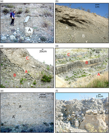
The succession in the SW face of the quarry (Fig. 6, log A; upper part) terminates with very coarse conglomerates that can be correlated with the F1 unit (Fanglomerate Group) at the top of the escarpment section. The F1 conglomerate in the quarry ranges from very poorly sorted to moderately sorted and is predominantly matrix-supported (Fig. 7a). However, clast-supported lenses (>80 % of the clasts) are also widespread. Overall, the clasts are subangular to angular and vary in size from <1 cm to >100 cm (average 6 cm). Individual conglomerate lenses vary in clast size and composition. Chalk clasts vary from 15 to 45 % of the total. The remainder of the clasts are ophiolite-derived, mostly gabbro and diabase, and are generally more rounded than the chalk clasts. Progradational (Gilbert-type) foresets (0.5–2 m thick) are locally well developed in the SW corner of face C (Fig. 7b). Large-scale cross-bedding and associated clast imbrication indicate palaeoflow towards the SE. The uppermost c. 4 m of the conglomerate, beneath the modern erosional surface, is heavily calichified.
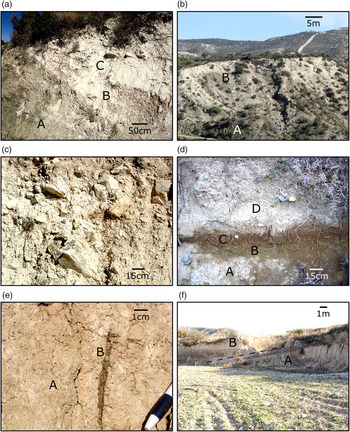
Field photographs of clastic sediments in Vasilikos Quarry. (a) F1 conglomerate. Weakly stratified, poorly sorted, with near-randomly sorted clasts, including outsized blocks of ophiolite-derived diabase (A); SW face of upper quarry re-entrant. (b) SE-prograding planar-bedded foresets (A) composed of relatively well-sorted pebbly conglomerate. Note the more extensive, relatively matrix-rich conglomerate above and below (B), as in (a). NE face of same quarry re-entrant. (c) F2 channel (A) eroded through F1 conglomerate (B) (see Fig. 6, enlarged inset). Note the pale, marly matrix and the poorly sorted clasts in the F2 deposit (C). Larger clasts are locally reworked from the F1 conglomerate. (d) F2 channel infill; NE face of the quarry. The lower conglomeratic package (partly hidden by reeds) (A) is followed by a mainly sandy interval (poorly exposed) (B) and then by a higher, conglomeratic interval (C), as detailed below; total thickness of conglomerate = c. 16 m. (e) Tabular cross-bedding (A) within pebbly conglomerate from the upper of the two aggrading intervals within the F2 deposits; viewed approximately at right angles to SE-directed palaeoflow. (f) Conglomerate-filled small channel cut into fluvial silt (A). The silt was armoured by caliche before being incised. Note the weakly developed normal grading in the conglomerate infill (B); pen for scale; same unit as (e).

A key finding is that the F1 conglomerate is abruptly terminated by a laterally persistent, inclined erosion surface that is reported here for the first time. This surface dips eastwards at up to c. 40° (Figs 6, sections; 7c). Crucially, this surface can be traced across quarry faces C and D to the base of face E, where it cuts into the Nicosia Formation, i.e. over a vertical height of c. 40 m from the unconformable contact with the Nicosia Formation to the top of the Pleistocene exposure (Fig. 5). The succession that unconformably overlies the Nicosia Formation in the northerly part of the quarry (Fig. 5, faces C and D) does not therefore represent the oldest part of the Pleistocene succession but rather the result of later-stage large-scale incision. The presence of an erosional unconformity explains the unexpectedly abrupt contact between the Nicosia Formation mudrocks and Pleistocene conglomerates, which contrasts strongly with the actual marine to non-marine facies transition that is exposed in the west of the quarry (Fig. 6, log A). The probable reason why this key inclined erosion surface (unconformity) was not reported before is that it is not clearly visible from the access track in the east.
The inclined erosion surface forms the base of a composite conglomerate and sand-dominated sedimentary package, which being the second oldest after the F1 conglomerate, is termed the F2 conglomerate. Within this interval, the base of the local succession decreases in angle of dip over several tens of metres away from the unconformity (towards the NE) and the clast size decreases (Figs 4, 6 (section and inset 1)). Ophiolite-derived clasts, mostly diabase, predominate near the unconformity, with a higher percentage of Lefkara Formation chalk clasts further away. Many of these clasts appear to have been reworked directly from the F1 conglomerate. Compared to the underlying F1 conglomerates, which contain little matrix, the F2 conglomerates have a buff to pinkish, silty to sandy calcareous matrix.
The F2 sedimentary package is made up of three distinct depositional intervals from the base upwards: a predominantly conglomeratic interval, a sandier unit and then another mostly conglomeratic interval (Figs 5, 6 (section and inset 1), 6 (log B, lower part), 7d–f).
The lower, predominantly conglomerate interval (as well exposed at the base of face D; Fig. 5) is c. 5 m thick and made of a clast-rich, clast-supported conglomerate, in which a coarse-gained matrix is locally present. Although still large, the average clast size (average 10 cm) is less than that within the F1 conglomerate. This lower interval of the F2 conglomerate is poorly sorted, with mainly subangular clasts that indicate imbrication, and thus palaeoflow, towards the SE, in agreement with Waters et al. (Reference Waters, Jones and Armstrong2010). The majority of the clasts are gabbro (40 %), chalk (35–40 %), and diabase (20 %) with a small percentage (<5 %) of plagiogranite. Diabase clasts tend to be relatively small (4 cm) and sub-rounded, whereas associated chalk clasts are larger (c. 10 cm) and commonly tabular (elongate in outcrop).
Above the lowest conglomerate interval in the F2 deposit there is a relatively sharp transition (tens of cm) to a second conglomerate-dominated interval (Fig. 6 section, Fig. 7d) that can be observed in both long profile (Fig. 5, face E) and cross-section (Fig. 5, face D).Along face E, sand and conglomerate are interbedded (Fig. 7d). Medium to coarse-grained, lenticular sands, with lithic fragments (<1 mm), increase in relative abundance towards the south (from 10–20 % to 80 %). Where the sand is dominant, the intercalated conglomerate lenses extend laterally for 2–15 m, vary in thickness (commonly 20–30 cm) and pinch out locally. Within these conglomerate lenses, the clasts are moderately well sorted by size and composition. The clasts are predominantly ophiolite-derived (60–80 %), with gabbro and diabase clasts being particularly dominant. Palaeocurrent data (clast imbrication and cross bedding) within the conglomerate and sand lenses again indicate flow towards the SE. Planar-dipping foresets (50 cm scale) occur towards the top of Figure 5, face E. On face D, the same interval reappears as discontinuous lenses of conglomerate (1–2 m thick × up to c. 4 m long), within a background of medium to coarse-grained sand. The clasts there are small (1–2 cm), sub-rounded, well sorted and fine upwards, with an increasing percentage of matrix upwards (i.e. between the individual coarse-grained lenses). Towards the NW, on Figure 5, face C, this sand–conglomerate interval is in direct erosional contact with the Nicosia Formation mudrocks beneath.
The contact between the second interval and the upper more laterally continuous, predominantly conglomeratic interval is highly irregular, including a 3–4 m deep, scoured channel (Fig. 7f) that is located on Figure 5, face E. This upper conglomeratic interval is dominated by disorganized, clast-supported conglomerate, with poorly to moderately sorted, sub-rounded clasts (average 5 cm; maximum >46 cm), again demonstrating imbrication towards the SE. Overall, c. 80 % of the clasts are ophiolite-derived (mainly gabbro and diabase) and c. 20 % chalk. However, the individual conglomerate lenses contain different proportions of clast lithologies. The clast size and relative clast abundance gradually decrease upwards, with a corresponding increase in coarse-grained sandy matrix, as exposed along Figure 5, faces C and D. Towards the west, the upper conglomerate package transgresses the Nicosia Formation with a sharp, irregular contact that can be traced upwards towards the south until an erosional contact with the F1 conglomerate (Fig. 6, section).
The above mainly coarse-grained package (F2) is followed by a sharp (several cm) but undulating change to a strongly contrasting, sub-horizontal-stratified finer-grained sedimentary interval (Fig. 6, section). The lower few metres of this are dominated by buff-coloured calcareous sands and silts (Fig. 6, log B; see also photographs in Supplementary Material available online at https://doi.org/10.1017/S0016756819001134). Above this, sandy sediment is intercalated with occasional conglomerate lenses (1–5 m thick) that contain moderately to well-sorted, sub-rounded clasts, set in a sandy matrix. Higher in the succession, the sediments change to dark brown/grey. Clasts diminish and then disappear. Above, there is a westward-thickening interval that is dominated by brownish to reddish layers (c. 17 m thick) that are interpreted as palaeosols. These sediments alternate with pale grey/buff-coloured, calcareous silts (Fig. 6, log B; see also photographs in Supplementary Material available online at https://doi.org/10.1017/S0016756819001134). The palaeosols contain occasional small (<1 cm) chalk clasts, charcoal fragments (up to 5 cm long × 3 cm thick) and roots/rootlets (up to 4–5 cm long × 2–3 cm thick), particularly in the stratigraphically higher layers. The uppermost palaeosol interbed (2–3 m thick) is very dark brown/red and intensifies in colour upwards to the present-day erosion surface (Fig. 6, log B; see also photograph in Supplementary Material available online at https://doi.org/10.1017/S0016756819001134). This deposit is unusually coarse-grained, poorly sorted and contains subangular to sub-rounded clasts (maximum 4.6 cm × average 2 cm). These clasts are randomly orientated, irregularly distributed and made up of 60 % chalk and 40 % ophiolitic rocks.
Within the palaeosols as a whole (along Fig. 5, face C), the relative size (0.5 cm to 8 cm) and abundance (<5 % to c. 65 %) of clasts relative to brown-coloured matrix increases for over 120 m laterally towards the SW. The clasts are predominantly ophiolite-derived (75–80 %), moderately sorted, vary from rounded to angular, range in size from <1 cm to 40 cm and generally fine upwards. In contrast, the interbedded pale grey/buff-coloured intervals are generally thicker (>1 m) and finer-grained than the brownish/reddish palaeosols and contain occasional small (<1 cm) clasts and roots (up to 6 cm long × 6 mm wide), together with common caliche nodules (see Supplementary Material available online at https://doi.org/10.1017/S0016756819001134).
Of particular note, the lowermost brown palaeosol, which grades upwards into fine to medium-grained grey/buff-coloured silt (c. 20 cm thick), includes well-developed caliche nodules towards the top, one of which was dated at 59 ka using the U-series whole-rock method (Waters et al. Reference Waters, Jones and Armstrong2010). The caliche nodules are fine-grained, hard and contain numerous small black specks of inferred organic matter, up to c. 3 mm in size (average c. 1 mm). The caliche also contains detrital grains of quartz, calcite, basic igneous rocks and bioclastic material (reworked) within a very fine-grained brown, muddy matrix, as seen in thin section.
In summary, Vasilikos Quarry and the adjacent escarpment document a Late Pliocene – Early Pleistocene aggrading marine succession (marine fan delta), passing upwards into thin, only locally exposed, non-marine conglomerates (non-marine fan delta). These sediments are overlain by very coarse fluvial conglomerates representing the major fluvial package (F1). This is, in turn, strongly incised into by a major lenticular conglomerate–sandstone package (F2), which is, in turn, directly overlain by grey/buff-coloured calcareous silts and reddish to brownish palaeosols. Evidence from the Vasilikos river valley, discussed below, allows all of these deposits to be correlated throughout the catchment.
4. Vasilikos river catchment
The geomorphology of the Vasilikos river valley (Fig. 8) is first outlined to provide a framework for the description and interpretation of the associated Pleistocene sediments. Several geomorphological surfaces within the Vasilikos river catchment can be identified as sub-horizontal features that vary in width, length and altitude, referred to here as terraces. Although discontinuous, both down-catchment and in cross-profile, some of the terraces can be correlated throughout the catchment, allowing the identification of four main geomorphological surfaces. These terraces are associated with locally preserved F1, F2, F3 and F4 deposits, with F1 being the highest and F4 the lowest, closest to the modern-day Vasilikos river course. However, correlation with the F1–F2 units exposed in Vasilikos Quarry is not initially assumed but will be demonstrated in the Discussion.

4.a. Geomorphology of Vasilikos river catchment
From its source at c. 1200 m asl, Vasilikos River flows approximately southeastwards over the Troodos Sheeted Dyke Complex for c. 7.8 km, and then turns east for c. 4.5 km (Fig. 2). The river flows over the Arakapas Fault and then sub-parallel to the lithologically variable Arakapas Fault Zone (South Troodos Transform Fault Zone) for c. 6 km. This highly tectonized ophiolitic belt (Fig. 9a) includes serpentinized ultramafic rocks (e.g. dunite, websterite, wherlite), gabbro (layered and massive), sheeted dykes, basaltic pillow lavas and small volumes of volcaniclastic rocks (Pantazis, Reference Pantazis1967; MacLeod & Murton, Reference Macleod, Murton, Prichard, Alabaster, Harris and Neary)1993). In its lower reaches (as defined here) the river flows SSE over ophiolite extrusive rocks, near very localized Fe–Mn sediments (umbers) and radiolarites (Perapedhi Formation), and then over extensive outcrops of chalk, marl and chert of the Maastrichtian–Oligocene Lefkara Formation (Robertson, Reference Robertson1976, Reference Robertson1977b). The river then flows over soft-weathering marl, chalk and Messinian-aged gypsum of the Miocene Pakhna and Kalavasos formations, and finally mudrocks of the Pliocene – Early Pleistocene Nicosia Formation (Pantazis, Reference Pantazis1967) (Figs 2, 8).
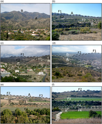
Photographs of geomorphological features taken in the upper (a–c), middle (d) and lower (e, f) reaches of the Vasilikos Valley. Terrace levels are indicated. (a) Terraces and surfaces are largely absent in the higher reaches above the dam because of the development of late Pleistocene dendritic drainage (A). View NW towards the Arakapas Fault Zone (South Troodos Transform Fault Zone) with the Troodos Mountains behind (B). (b) Well-preserved F1 and F2 terraces in the upper reaches (A). In this area, the F3 terrace is dissected by younger streams (B). View SW along profile c in Figure 8. (c) Landscape readjustment in the upper reaches. F1 is the highest elevation. The valley sides curve gently down to the F2 terrace, representing the next break in slope. There is then a steeper break in slope between the F2 and F3 levels on both sides of the valley. The F4 is represented by the valley floor. Note the decreasing vertical distance between each of the F1 to F4 terrace levels. View north from Kalavasos at profile d in Figure 8. (d) Constriction of the valley south of Kalavasos (A) (intermediate reaches), followed by widening and flattening downstream (B). F1 is the highest level, with F2 as the next break in slope. The F3 terrace is not well preserved around Kalavasos. The fields and houses lie on the F4 terrace. View south from above Kalavasos at profile e in Figure 8. (e) F2, the highest preserved terrace level (lower reaches), tapers out down-valley, merging with the F3 surface (A). F4 surfaces are well developed on both sides of the modern channel (B) (fields). View from Mari looking east; between profile h and I in Figure 8. (f) F2 forms the highest terrace on the west side of the river valley (lower reaches). F3 forms a well-developed, wide terrace. The F4 terrace on both sides of the modern channel (A) is also well developed but narrower. View west along profile j in Figure 8.

Topographic profiles (Fig. 10) of the present-day valley were constructed to help indicate the distribution of geomorphological surfaces. The profiles were constructed from near the south coast for c. 10 km northwards as far as Vasilikos Dam (Fig. 8). Geomorphological surfaces cannot be traced directly northwards beyond this because there is an abrupt change to an area of immature dendritic drainage with little evidence of preserved terraces (Figs 8, 9a). However, mature erosional surfaces and related sediments (e.g. conglomerates and palaeosols) reappear closer to the river source, especially within the Arakapas Fault Zone. The northward change from an immature to a more mature drainage pattern suggests the presence of one or more northward-retreating nick points which have yet to reach the E–W-trending Arakapas Fault Zone (although this will not be considered further here).
Same-scale topographic profiles derived from ArcGIS showing large-scale changes down-catchment (see Fig. 8 for locations). Note the locally preserved F1–F4 terraces (solid red lines) and extrapolations (dashed blue lines).

For descriptive purposes, the stretch of the valley that was studied in detail (south of Kalavasos Dam; i.e. lower reaches) is here subdivided into three distinct geomorphological segments, namely the upper reaches (Fig. 10a–d), the middle reaches (Fig. 10e, f) and the lower reaches (Fig. 10g, j) of the Vasilikos river catchment. Profiles (a–c) (Fig. 10) indicate that the valley is wide in the upper reaches (over c. 5 km), with moderately steep slopes. Three geomorphological surfaces are separated vertically by a total of c. 100 m. Further south the channel narrows, with the Asgata Potamos tributary coming in from the NW (Fig. 10d). In the middle reaches, including Kalavasos village (Figs 8, Fig. 10e, f), the river channel passes through a steep gorge (c. 70 high × up to 800 m wide). This narrowing corresponds to the river passing through the relatively resistant chert-bearing interval of the Palaeogene Lefkara Formation, suggesting a lithological control on fluvial incision (see Discussion). Geomorphological surfaces within the gorge are restricted to narrow (several metres wide) low-amplitude (several metres high) benches or ribs. In the lower reaches, south of Kalavasos village (Fig. 10g-j), the active channel cuts into relatively soft Miocene Pakhna Formation chalks and marls and the valley widens greatly (to c. 1200 m wide). Three to four major geomorphological surfaces in this interval are separated, vertically by tens of metres. However, small slope irregularities locally exist between these marked surfaces, suggesting a complex and variable incision history (e.g. Fig. 10d, f for F3; Fig. 10a for F2).
Overall, four distinct types of geomorphological surface are identified, as shown on the same-scale topographic profiles with terrace conglomerates added (Fig. 11). Where sediments are present, the terrace surfaces correspond to the tops of the sedimentary infills of incised fluvial channels.
Comparative topographic profiles (the different scales highlight sediment abundances down-catchment): (a–d) upper reaches, (e, f) middle reaches and (g–j) lower reaches. The fluvial terrace deposits are marked as: (t) undifferentiated terraces; (d) terraces associated with sediments; (s) geomorphological surfaces without sediments; (r) remnant or partially eroded terraces. See Figure 10 for more detailed (same-scale) topographic profiles and Figure 8 for locations.

The upper reaches are dominated by three terrace levels at c. 300, 200 and 75 m asl (Fig. 11a–d). On its SW side, the highest level of the valley locally corresponds to the F1 geomorphological surface with rare preserved conglomerates (Fig. 8). However, on the NE side of the valley the F1 surface is marked by a break in slope at c. 310 m asl without preserved fluvial conglomerates. There are hints of an older (unstudied) remnant surface above this (Fig. 11a).
Below the remnant F1 surface, hillslopes are initially steep but shallow downwards into sub-horizontal surfaces, with a marked break in slope, corresponding to a distinct surface at c. 220 m asl (Fig. 11a). This second surface is associated with coarse conglomerates, defined as the F2 terrace, which are semi-continuous on the western slopes of the catchment for >3 km (Figs 8, 11a–d). Colluvial deposits (i.e. slope-related unconsolidated sediment) are very well developed at topographic heights between the F2 terrace and the F3 terrace (c. 150 m asl), especially in the upper and middle reaches, between Kalavasos and Vasilikos Dam (Fig. 9c).
Directly SE of Vasilikos Dam (Fig. 8), the modern river channel lies within a narrow (c. 20 m wide), steep-sided (c. 20 m deep) gorge (Fig. 11b). Above the gorge, the topography broadens out greatly, with a narrow (<20 m) but well-defined terrace on the SW side of the valley and a much wider (c. 500 m) undulating, discontinuous terrace on the NE side of the valley. This extensive surface represents the F3 terrace at c. 75 m asl. Unlike the F2 terrace, the F3 terrace is in places laterally continuous for >100–200 m, particularly on the NE side of the valley, where it is dissected by small tributary channels (Figs 8, 9b).
Within the upper reaches, the F3 terraces can also be traced from the Vasilikos Valley, near Kalavasos, northwestwards for several kilometres up the adjacent Asgata Potamos tributary valley (Figs 8, 10d). The highest elevations in this segment of both valleys (c. 270 m asl) correspond to a series of ridges that are correlated with the F1 terrace. Major breaks in slopes occur at the same heights (c. 200 and c. 140 m asl) in both valleys and are associated with similar geomorphological surfaces which are correlated with the F2 and F3 surfaces. On the floor of Asgata Potamos valley, a series of narrow (<15 m wide), sloping surfaces occur 5–6 m above the active channel and are continuous up-valley for c. 2 km. These localized surfaces correlate with lower, wider (c. 200 m), gently sloping, better-developed surfaces in the main Vasilikos valley. These features, which first appear at c. 130 m asl and are continuous down-catchment, are interpreted as the F4 surface, which becomes progressively better developed in the lower reaches. This overall evidence suggests that the two palaeovalleys, despite differing lengths and source lithologies, underwent a similar geomorphological and sedimentary development.
In the middle reaches (Figs 8, Fig. 11e, f), the overall valley height decreases from c. 180 m to c. 135 m asl. The F2 is the highest preserved surface (c. 120 m asl) on the eastern side of the valley (Fig. 11f). Between the upper and middle reaches, the valley narrows from c. 3 km to c. 1.5 km and as a result the F1 and F2 surfaces are much closer together than in the upper reaches.
Near Kalavasos, the valley is constricted, steep-sided and retains only localized remnants of the F3 and F4 terraces (Figs 9d, 10e). F2 deposits are rarely preserved as a narrow, discontinuous rib on the west side of the valley (Fig. 8). F3 and F4 terraces are more widely preserved but lack identifiable geomorphological surfaces on both sides of the valley. The F4 surface is well preserved as a continuous feature (c. 150 m wide) on the western margin of the valley, although it decreases in width from c. 150 m to <20 m towards Kalavasos as the channel narrows (Figs 8, 10e). Beyond where the river leaves the confinement (Figs 8, 11f), the F3 terrace reappears as a well-preserved feature (c. 70 m wide) on the western side of the valley. The F3 terrace is also present there as a narrow (c. 20 m), upward-sloping remnant on the valley’s eastern side (c. 100 m asl) (Figs 8, 10f). The F4 terrace is only locally preserved on the western side of the valley, increasing to c. 75 m in width.
The lower reaches of the Vasilikos Valley are broader and flatter (Fig. 10g–j). The F1 surface is patchily preserved as a remnant surface on the western side of the valley, above Mari village (c. 115 m asl) (Figs 8, Fig. 10h). Although discontinuous (Fig. 9e), the F2 remnant terrace forms the highest surface within the valley in the vicinity of Tenta (c. 95 m asl) (Fig. 10g). In contrast, the F3 terrace is increasingly well preserved down-catchment, enlarging from remnant surfaces at Tenta (Figs 8, Fig. 10g) to wide (c. 65 m in the east vs c. 600 m in the west), gently dipping terraces near Mari, at c. 50 m asl (Fig. 10i). The upper surface of the F3 terrace is generally characterized by a series of palaeosols, which overlie F3 clastic deposits, culminating in dark red/brown palaeosols on both sides of the valley (Fig. 11i, j). The position of the top of the upper terraces on the west side of the valley (Fig. 10j) is indeterminate owing to quarrying. The extensive palaeosols on the F3 surfaces are very similar to those exposed in Vasilikos Quarry (see above). None of the other surfaces expose similar bright reddish-coloured palaeosols although reddish to brownish palaeosols occur at several different levels in the palaeovalley including the late Pleistocene, intercalated with harvara (colluvium).
In the wide lower reaches (Figs 9f, 10g–j), the F4 terrace is well established near the valley floor, c. 4–5 m above the present-day channel on both sides of the valley. In this segment, there is a marked change in slope gradient from sub-horizontal to steeply dipping between the F3 and F4 terraces (Fig. 11f). The present-day channel meanders in the lower reaches.
4.b. Vasilikos river deposits
The sequential river deposits are classified according to the geomorphological surface that they overlie conformably and are illustrated on the geological map (Fig. 8), same-scale simplified topographic profiles (Fig. 11a–f) and photographs (Figs 12, 13).
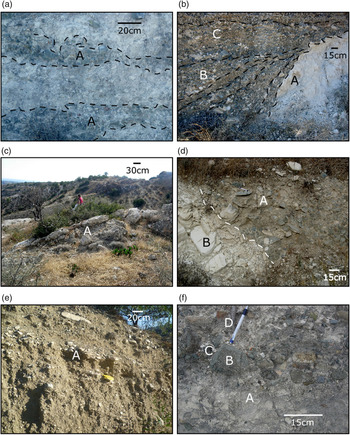
Field photographs of key features of the F1 and F2 deposits in the Vasilikos river catchment. (a) Thin F1 conglomerate consisting of small (1–2 cm), poorly sorted, subangular, predominantly ophiolite-derived clasts in a fine-grained matrix. The conglomerate forms discontinuous (3 m), thin (40 cm) lenses (A) which are heavily calcretized; above Kalavasos along profile e in Figure 8. (b) Relatively thick, well-bedded conglomerate (F2). The contact (A) between the conglomerate and the Lefkara Formation bedrock is steep and highly irregular as a result of fluvial erosion. As a result of local slope increase, the conglomerate accumulated as prograding foresets (1–2 m) (B). Clasts are poorly to moderately sorted, subangular to rounded and coarsen upwards (C). View along profile f in Figure 8. (c) Inclined (23°) blocks (up to 2 m across) of calichified conglomerate on the hillside (A). The blocks were reworked from the topographically higher F1 conglomerate terrace as a result of landscape adjustment processes. View c. 20 m downhill from (b); along profile f in Figure 8. (d) Contact between the F2 conglomerate (A) and the Lefkara Formation bedrock (B), above Kalavasos. The uppermost chalks below are reworked as clasts in a fine-grained matrix, overlain, with a c. 45° contact, by moderately sorted conglomerate with a mixture of sub-rounded to rounded, predominantly ophiolite-derived clasts (A); along profile e in Figure 8. (e) Matrix-rich, poorly to moderately sorted, weakly bedded conglomerate with c. 75 % chalk clasts and c. 25 % ophiolite-derived clasts. The beds dip (A) towards the SW with local clast imbrication in this direction; east side of valley, just below the Kalavasos Dam; along profile a (Fig. 8). (f) Matrix-rich, poorly sorted conglomerate with a marly matrix (A). The largest clasts (B) are ophiolitic diabase (e.g. near pen top), which were rounded and then, in some cases, broken, prior to final deposition. The smaller clasts (C) are mainly silicified chalk (white) from the Lefkara Formation and jasper (D) related to the Troodos ophiolite. The clasts represent a concentrate of the most erosionally resistant lithologies; F2 conglomerate west of, and above, Kalavasos.

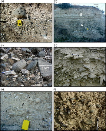
Field photographs of key features of the F3 and F4 deposits in the Vasilikos river catchment. (a) Two different conglomerates (contact marked by white dashed line). The lower conglomerate (A) (F3 terrace level) consists of sub-rounded, mostly ophiolite-derived clasts within a dark medium-grained sandy matrix. The upper conglomerate (B) is a more chalk-rich conglomerate containing subangular to angular chalk clasts within a fine-grained chalky matrix. Occasional outsized ophiolite-derived clasts (C) are likely to have been reworked from older terraces; small tributary in the upper reaches on the west side of the valley; profile c in Figure 8. (b) F3 conglomerate typical of the lower reaches (A) overlain by brown/reddish palaeosols alternating with paler silty horizons interpreted as poorly developed cold-climate palaeosols (B); west side of the valley, near Mari, profile I in Figure 8. (c) F3 conglomerate (lower reaches) made up of poorly to moderately sorted, sub-rounded clasts within a fine to medium-grained, lithic fragment-rich matrix. Clasts (c. 50 % chalk and c. 50 % ophiolite-derived) indicate palaeoflow to the south; east side of the valley just below road; profile j in Figure 8. (d) F3 chalky colluvial deposit with c. 95 % chalk clasts (middle reaches). The fabric is weakly stratified; clasts are subangular–angular, blocky, elongate and poorly to moderately sorted, with a fine chalky matrix; west side of the valley between Kalavasos and Tenta (see Fig. 8 for locations). (e) Near-basal F4 conglomerate (middle reaches) close to the active channel. The conglomerate is mud matrix-rich with small sub-rounded clasts (mostly chalk) (A). Palaeoflow is to the south based on weakly developed clast imbrication (B); southern outskirts of Kalavasos, in fields along profile f in Figure 8. (f) F4 conglomerate (lower reaches) made up of small, sub-rounded to subangular, poorly to moderately sorted, clasts within a fine-grained, muddy matrix; close to active channel along profile j in Figure 8.

4.b.1 F1-related facies
Deposits associated with the F1 terrace are limited to the middle reaches, close to Kalavasos. NW of Kalavasos (Fig. 14.F1a), the F1 (c. 4.5 m thick × c. 20 m across) is conglomerate with poorly sorted, subangular clasts, set in an abundant fine-grained (calcretized) matrix. The conglomerate occurs as very small (unmappable) discontinuous lenses, up to 3 m long × 40 cm thick (Fig. 12a). The clasts are small (average c. 1–2 cm) and become better-sorted upwards. Larger clasts (maximum 8 cm) mainly occur near the base of individual lenses. The clasts exhibit weakly developed imbrication towards the SE. Most of the clasts are ophiolite-derived (c. 70 %), with the remainder (c. 30 %) being chalk from the Lefkara Formation. The sedimentary clasts are usually relatively small (average c. 1 cm), elongate and angular.
Sedimentary logs of terrace deposits in the Vasilikos river catchment. The logs are identified by F number (F1–F4) and by small letter for different logs of each terrace. Locations are marked in Figure 8.

The F1 terrace deposits SW of Kalavasos (Fig. 11f), although restricted to the western margin of the Vasilikos River (on either side of distributaries), are more extensive (c. 3–4 m thick × 35 m across), and differ in facies from the conglomerates further northwest. The contact between the Lefkara Formation bedrock and the conglomerate is locally steep and highly irregular, indicating fluvial incision into bedrock (1–2 m thick) (Fig. 12b). The overlying conglomerate is covered by prograding foresets (c. 30 cm thick) that vary from matrix- to clast-supported and are calcrete-cemented. The dip locally steepens towards the bedrock. The clasts are poorly to moderately sorted, subangular to rounded, and coarsen upwards (<1 cm at the base vs >10 cm at the top). Individual lenses vary in size and composition, with typically 65–70 % ophiolite-derived clasts and c. 30 % Lefkara Formation clasts. Clast imbrication is absent, although occasional large clasts (up to c. 47 cm) are aligned parallel to bedding. On the hillslope, c. 20 m below intact exposures, large (up to 2 m thick), steeply inclined bodies of calcrete-cemented conglomerate are interpreted as slip-blocks from the terrace above (Fig. 12c). The F1 fluvial deposits were therefore incised into bedrock in some places and the fluvial deposition was strongly influenced by the stream-bed topography.
4.b.2. F2-related facies
Preservation of the F2 terrace deposits increases down-catchment. In the upper reaches, the deposits are restricted to near Vasilikos Dam, exemplified by a thin (c. 80 cm), localized exposure on the SW side of the valley (Fig. 11a). This conglomerate comprises well-cemented clasts (70 %) within a white chalky matrix (30 %), and includes small (average 1 cm; maximum 3 cm), angular, predominantly (c. 95 %) ophiolite-derived clasts. At the equivalent height on the NE side of the valley there is a contrasting, thicker poorly sorted conglomerate (up to 20 m thick), which is dominated by chalk clasts (>c. 95 %) within a very fine-grained chalky matrix. This deposit overlies weathered pillow lavas with an irregular, undulating contact. Lenticular bedding is visible (c. 30 cm scale), with subangular to angular clasts (<0.5 cm to >10 cm). Similar-sized clasts are concentrated within individual conglomerate lenses. This chalk-rich conglomerate is interpreted as a texturally immature colluvial deposit which overlies an inward-sloping erosional surface (see below).
Lower on the hillside, indistinctly bedded, clast-poor (30 %) conglomerate is exposed 30 m in altitude below the colluvium mentioned above (Figs 12e, 14.F2a). This dips towards the SW (15/195°, 14/201°, 15/198°) and has a smaller proportion of chalk clasts (75 %) vs ophiolite-derived clasts (25 %), compared to the colluvium. The clasts are relatively large (4–5 cm, maximum 57 cm), poorly to moderately sorted, subangular to angular, and locally imbricated towards the SW.
In the middle reaches, both north and south of Kalavasos (Fig. 14.F2b), the F2 deposit is a represented by conglomerate, up to 18 m thick, with a calcretized upper surface. This conglomerate overlies the Lefkara Formation with a gently undulating, steep-sided contact (Fig. 12d). The clasts fine upwards, from an average of c. 4 cm at the base, to c. 2 cm at the top, although outsized clasts (up to 30 cm) are present throughout. The base of the conglomerate is clast-supported, with a fine-grained, grey, silty matrix that increases in relative abundance upwards. The clasts are sub-rounded to rounded, and poorly to moderately sorted, with weakly developed imbrication towards the SE. The clasts were derived from the ophiolite (c. 65 %) and from the Lefkara Formation (c. 35 %).
In the lower reaches, near Mari, F2 conglomerates (c. 5 m thick), cemented by calcrete, directly overlie the Pliocene – Early Pleistocene Nicosia Formation (Fig. 14.F2c). The conglomerate is irregular downslope, forming undulations (1–3 m in amplitude). Clast-supported near the base, this conglomerate becomes increasingly matrix-supported upwards. The clasts are poorly to moderately sorted and grade upwards, with smaller (1–2 cm) than average-sized clasts (c. 6 cm), towards the top of the deposit. Smaller clasts (c. 3 cm) infill depressions in the bedrock, whereas larger ones (maximum 38 cm) are distributed randomly throughout the conglomerate.
4.b.3. F3-related facies
The F3 deposits, up to 40 m thick, are well preserved within all three reaches of the Vasilikos river catchment. In the upper reaches, the basal contact with the underlying ophiolitic pillow lavas undulates gently (Fig. 14.F3a) and steepens towards the NE margin of the exposure. This conglomerate varies from clast-supported to matrix-supported. The matrix is grey, medium-grained sand with lithic fragments. Increasingly clast-supported intervals occur both towards the base and the top of the deposit. The clasts are poorly to moderately sorted, fine upwards (average 18–20 cm at the base vs 1–3 cm at the top) and are imbricated towards the SE. The uppermost conglomerate contains well-developed caliche (c. 3 m thick). In the upper reaches the deposits occur at several topographical levels along the eastern side of the valley, but these are man-made (agricultural) benches within the same F3 deposit.
A small tributary channel on the western side of the valley is infilled with typical F3 conglomerate (Fig. 8, just NE of profile c). The lower levels (1.5 m) of the deposit are similar to those on the opposite, eastern side of the valley (Fig. 13a, lower unit). Large (average 5–6 cm; maximum 17 cm), subangular to angular chalk clasts (5–10 %) are locally concentrated in the uppermost c. 40 cm of the deposit. The uppermost levels (c. 1 m thick) of this deposit contain >95 % chalk clasts, which are small (4 cm; maximum 28 cm), subangular to angular, and poorly sorted, within a fine-grained chalky matrix, together with occasional much larger ophiolite-derived clasts that are likely to be reworked (Fig. 13a, upper unit). The proportion of chalk clasts increases laterally from to east to west, away from the valley axis (from 90 to 15 %).
Within the middle reaches (e.g. east of Kalavasos), the basal contact of the F3 conglomerate undulates. The conglomerate, which is up to c. 40 m thick, is clast-rich and matrix-supported. The matrix is fine-grained, silty, lithic fragment-rich and increases upwards within individual depositional units. Clasts are generally poorly sorted to moderately sorted, and imbricated towards the S or SE. The clasts fine upwards (c. 7 cm at base vs c. 2 cm at the top), and change from rounded to subangular on average upwards. The uppermost conglomerate (c. 5 m) is rich in caliche, as seen on the west side of the valley south of Kalavasos (Fig. 11f). There is general increase in chalk and chalk–chert clasts (Lefkara Formation) in the middle reaches (Fig. 14.F3b,c), averaging 30 % to 45 % , compared to the upper reaches.
Also, within the middle reaches, the F3 conglomerates are typically overlain by colluvial deposits. These are weakly bedded (5–10 cm scale), made up of c. 95–100 % chalk clasts, with the addition of occasional gypsum clasts downstream of the in situ outcrop (Fig. 14.F3b, c). The chalk clasts vary in size (0.5 cm to >10 cm), are randomly orientated, mostly highly angular, poorly to moderately sorted, and set within a fine-grained, sandy, silty or chalky matrix (Fig. 13d). Weak clast imbrication towards the SW is locally developed near the base of the deposit (Fig. 14.F3b). West of Kalavasos, colluvium near the underlying F3 fluvial conglomerate contains subangular to sub-rounded ophiolite-derived clasts that increase in size (up to 6–7 cm) and relative abundance (up to 40 %) towards the east (axially).
A small slope-cut of relatively fine-grained colluvium (harvara; see below), together with reddish-brown palaeosol (poorly developed terra rossa) was previously studied by Schirmer (Reference Schirmer1998) and later by Kinnaird et al. (Reference Kinnaird, Robertson, Robertson, Parlak and Ünlügenç2013) along the SW edge of Kalavasos village (c. 150 m south of the village church). The sampled section is c. 5 m high, up a track off the main road through the village (GPS UTM 34° 46′ 08″ N; 33° 17′ 47″ E). The site is c. 30 m above the valley floor where the slope toe begins to flatten. Re-examination of the exposure indicates that it begins with brownish recessive-weathering palaeosol (Gondéssa soil) from which a radiocarbon age of 31.970 ka was determined. An OSL (optically stimulated luminescence) age of estimate of 29.82 ± 2.11 ka was obtained from this palaeosol (Kinnaird et al. Reference Kinnaird, Robertson, Robertson, Parlak and Ünlügenç2013). This is followed, with a transition over several centimetres, by buff-white harvara (c. 2.9 m thick) with poorly sorted angular clasts (<5 cm in size), mainly chalk. Scattered clasts of chert (formed by replacement of chalk) are also present, up to 15 cm in size, and a few rounded basalt pebbles (<4 cm in size). Transitionally above (over several centimetres) there is then a second palaeosol (Lower Tsiáko Soil), which is distinctly brown, with smaller clasts than the palaeosol beneath, followed by a second harvara (up to 80 cm thick) with scattered relatively large clasts (up to 35 cm in size), and then a third (laterally discontinuous) palaeosol (Upper Tsiáko Soil). Further harvara follows (up to c. 1.5 m thick), from which charcoal near the base was radiocarbon-dated at 27.44 ± 1.6 ka (Schirmer, Reference Schirmer1998). Reworking of organic matter from the directly underlying palaeosol can be considered, although this would not significantly change the depositional age.
The section ends with redeposited palaeosol and harvara with a caliche capping.
In the lower reaches, the well-cemented F3 conglomerate (10 m thick) is matrix-supported, although with clast-supported lenses (Fig. 14.F3d). The matrix is fine to medium-grained sand, with lithic fragments. Most clasts are poorly to moderately sorted. Clasts of similar size and composition are sorted into lenses (c. 2–3 m long × c. 20 m high), with better sorting in the clast-supported lenses. Clasts vary in size (averaging 4–6 cm), but generally fine upwards from a maximum (38 cm) near the base. Exposures near Mari contain 60–70 % ophiolite-derived clasts and 30–40 % chalk clasts, which are imbricated towards the SE. Downstream, the proportion of ophiolitic vs chalk clasts decreases (to c. 50 %), with south-directed clast imbrication (Fig. 13c). The calichified top of the F3 deposit forms an extensive sub-horizontal geomorphological surface which underlies modern-day agricultural fields.
The F3 conglomerates near Mari are overlain by highly distinctive palaeosols on both sides of the valley (Fig. 6 inset 2). Where best developed on the east side of the valley (Figs 13b, 14.F3d), the contact between the F3 deposit and the palaeosols above is irregular and locally undulating due to erosion. The palaeosols are locally intercalated with lenticular conglomerates. Dark-brown to grey, fine-grained, poorly consolidated palaeosols alternate with paler, white/yellow fine-grained silts (Fig. 13b, upper part). The silts contain numerous small (<1 mm) lithic fragments and occasional caliche horizons. Relatively large clasts (>1 cm) are scattered through both the darker and paler-coloured deposits. Clasts of similar size, composition and angularity characterize specific horizons. The uppermost horizon is a very dark brown/red fine-grained palaeosol which continues downstream above caliche-rich conglomerate.
4.b.4. F4-related facies
In the upper reaches, the F4 (and/or younger) deposits are restricted to clasts within the modern channel. F4 deposits in the middle and lower reaches are largely fine-grained, grey to light-brown silt which supports rich farmland. Where they first appear widely, directly south of Kalavasos (Fig. 14.F4a), the silts include small (average 1–2 cm; maximum 8 cm), scattered, sub-rounded to subangular clasts, mostly chalk (Fig. 13e). The relative abundance and size of the clasts increases southwards (Fig. 14.F4b), averaging 2–3 cm opposite Tenta. Larger clasts (maximum 25 cm) tend to be concentrated in lenses towards the top of the deposit. The clasts are subangular, moderately to well sorted, and have localized imbrication towards the S-SE. Excavated pits in the lower Vasilikos Valley have revealed three to five layers (each several cm thick), composed of silt with intercalated calcareous layers (Gomez, Reference Gomez1987).
The F4 deposits in the lower reaches (Fig. 14.F4c) comprise two distinct intervals, a lower (c. 80 cm thick) clast-rich muddy, matrix-supported conglomerate, and an upper (c. 70 cm thick) fine-grained, muddy palaeosol that is similar to the F4 deposits further up-valley. Clasts within the lower unit (Fig. 13f) are small (average 3 cm), but with occasional outsize clasts (up to 47 cm). The clasts are poorly to moderately sorted and subangular to sub-rounded, with weakly developed imbrication towards the SE.
The axis of the F4 channel was incised downwards by up to c. 6 m, followed by alluvial deposition between 5400 and 5010 BC (Gomez, Reference Gomez1987). Downcutting to within 2 m of the present floodplain took place during post-Byzantine times, as documented elsewhere in S Cyprus (JA Gifford, unpub. PhD thesis, Univ. Minnesota, 1978).
In summary, the combined geomorphological and sedimentary evidence demonstrates four main stages of Pleistocene geomorphological and sedimentary development (F1–F4) which can now be compared with those recognized in Vasilikos Quarry.
5. Discussion
5.a. Correlation of the Vasilikos quarry and valley deposits
The two independently determined stratigraphic schemes can be correlated based on three main related lines of evidence.
1 Geomorphology. The top of the F1 terrace, as seen in Vasilikos Quarry, represents the highest preserved geomorphological surface, as does the F1 throughout the Vasilikos river catchment (Figs 10, 11). These F1 surfaces can be visually correlated from the escarpment c. 1.8 km NW of the quarry (Fig. 3b), across a topographic depression that is occupied by the Limassol–Nicosia highway, to the northward-rising topography (towards Kalavasos). The F1 surfaces in both areas are heavily calcretized, representing prolonged subaerial exposure during which erosional and depositional processes mainly took place at lower topographic levels.
2 Stratigraphy. Of the four stages of development in the Vasilikos river valley (F1–F4), two (F1 and F2) can be recognized on lithological grounds in Vasilikos Quarry. However, the F3 and F4 conglomerates are not developed at Vasilikos Quarry. This reflects post-F2 fluvial incision which located these younger deposits at lower topographic levels near the modern river channel (c. 1 km to the east). The river channel is likely to have migrated eastwards after the F2 deposition as no equivalent of the relatively thick F2 conglomerates is preserved on the opposing eastern margin of the modern river channel.
3 Sedimentology. The F1–F3 deposits show many similar features in both the lower reaches of the river valley and the quarry. The F1 deposits in both areas are sheet-like, extensively distributed at relatively high topographic levels and include, on average, the largest clasts, mainly of ophiolite-derived rocks. The incised F2 deposits in both areas also show marked similarities in both areas, including erosive bases, lenticular (channelized) morphology, sedimentary structures, clast size, clast maturity, matrix type and relative abundance. The intense brown to dark reddish-coloured palaeosols are highly distinctive and occur only on the F3 fluvial deposits in Vasilikos Valley and also depositionally above the F2 conglomerates in the quarry. The occurrence of these palaeosols in the quarry above the F2 conglomerates is at first sight anomalous because F3 deposits (with overlying palaeosols) are incised into F2 conglomerates in the river valley. However, this can be explained by accumulation of the palaeosols on the upper, westerly slopes of F3-related palaeovalley (Fig. 8), well away from the then active channel. Fluvial material derived from the main river channel is absent, and the material accumulated as soils on a weathering and eroding landscape. Similar-coloured palaeosols developed on valley slopes adjacent to the F3-aged river channel, especially in the mid to upper reaches of Vasilikos catchment, especially north of Kalavasos.
5.b. Geomorphological development of the Vasilikos river catchment
In general, the valley profiles have deepened and narrowed through time, especially in the middle and upper reaches (Fig. 10), representing successive stage of incision. However, the channel generally widened and shallowed in the lower reaches, down to the modern coast, largely reflecting the relatively soft rheology of the underlying mudrock (Nicosia Formation).
The geomorphological development of the headwaters of the Vasilikos river catchment to the north of Vasilikos Dam was not studied in detail. However, for >1 km north of the dam the F1–F4 terraces are replaced by a young dendritic drainage pattern (Figs 8, 9a). This feature could represent the development of markedly steeper slopes above relatively resistant ophiolitic rocks (e.g. diabase/gabbro) with correspondingly increased incision and erosion of pre-existing terrace deposits. Structural control (relative uplift) could have a similar effect, although there is no direct evidence of this (see below). Further northwest, within the Arakapas Fault Zone (Fig. 2), the Vasilikos River flows down more gentle slopes, possibly isolated above one or more nick points (although this remains to be tested). Within the Arakapas Fault Zone, well-developed erosional surfaces reappear close to the present-day Vasilikos River. Morphologically, these are similar to the F3 surfaces south of Vasilikos Dam. The associated deposits are mainly thin (<5 m) ophiolite-derived conglomerates with a reddish sandy matrix, covered by distinctive, reddish terra rossa palaeosols.
South of Vasilikos Dam, the dominant control on the geomorphology within the upper, middle and lower reaches is interpreted to be lithology, as supported by the geological map (Fig. 8) and the topographic profiles (Figs 10, Fig. 11). The upper reaches (Fig. 11a–c) are underlain by the Lower Pillow Lavas of the Troodos ophiolite near Kalavasos Dam, and by the Upper Pillow lavas towards Kalavasos (Pantazis, Reference Pantazis1967). The Lower Pillow Lavas are predominantly massive and pillowed flows with much fragmental material (lava breccia and hyaloclastite) that erodes readily. The F3 deposits directly overlie the Lower Pillow Lavas on the east side of the valley, where they have been largely removed by small tributary channels. In contrast, the F3 deposits are better preserved on the west side of the valley where the bedrock is more resistant to erosion. The Upper Pillow Lavas, although composed of comparable extrusive lithologies, are generally more indurated in this area as a result of hydrothermal alteration and sea-floor weathering and support locally steeper valley slopes (Pantazis, Reference Pantazis1967), as reported from the north-Troodos Akaki river catchment (Main et al. Reference Main, Roberston and Palamakumbura2016).
In the middle reaches (Fig. 11e, f), the bedrock is dominated by chalks of the latest Cretaceous–Oligocene Lefkara Formation (Fig. 2). The Vasilikos river valley gradually narrows southwards, culminating in a pronounced constriction (just south of Kalavasos), which is coincident with erosionally resistant bedded and nodular chert making up the Middle Lefkara Formation (Pantazis, Reference Pantazis1967). Incision of this highly resistant interval resulted in steep channel margins, leaving only a narrow preserved rib of F2 deposits on the steep westerly slope and a thin strip of F3 deposits on the lower eastern valley slope, without a preserved F3 terrace. The local development of the F4 terrace on the lowest west side of the valley is interpreted as the inner bend of a small meander within the previously incised valley, where locally reduced stream velocities resulted in fluvial aggradation.
The lower reaches (Fig. 11g–j), where the valley broadens and shallows, are underlain initially by the soft-weathering limestones, marls, chalks and local evaporites of the Miocene Pakhna Formation, and further down-catchment by mudrocks and marls of the Pliocene – Early Pleistocene Nicosia Formation. Asymmetrical topographic profiles contrast with further upstream (Fig. 11a–c, e). This, and the marked variation in the width of the preserved F4 terraces, points to meandering of the river channel in this area.
5.c. Fluvial processes
Poorly to moderately sorted, clast-rich, matrix-supported conglomerates with outsized clasts (>1 m) are best represented by the F1 conglomerates (Fig. 7a), which are interpreted as very high-energy mass-flow accumulations, i.e. debris-flows and hyperconcentrated-flow deposits (Harvey et al. Reference Harvey, Mather, Stokes, Harvey, Mather and Stokes2005; Waters et al. Reference Waters, Jones and Armstrong2010). Spasmodic flash floods introduced packages of similar-sized clasts of similar composition, although individual depositional units vary (see ‘Sediment provenance’, below). Such flash floods were highly erosive, as inferred from their irregular, eroded basal contacts (Fig. 12b). In the Vasilikos river catchment, bedrock chalks were locally scoured into to form depressions that were infilled by foresets, marking the base of high-energy conglomerates. North of Kalavasos (Fig. 12a), clasts in the F1 conglomerates are relatively small, well sorted and lenticular, with some clast imbrication. These conglomerates were deposited from a weaker flow with a higher degree of traction current activity compared to the coarser deposits preserved further south. The finer chalk-rich conglomerates are likely to have accumulated in a relatively marginal position where stream energy was reduced. Conglomerates, which are relatively well sorted and show clast imbrication, generally to the S-SE, represent the accumulation from sustained traction-flow processes (Collinson, Reference Collinson and Reading1996; Waters et al. Reference Waters, Jones and Armstrong2010). Locally developed tabular foresets, mainly in the F1 and F2 conglomerates(Fig. 7e), are indicative of foreset progradation during short periods of high-energy, sustained flow when clasts rapidly infilled local accommodation space (Miall, Reference Miall1996). Sorting, clast size and imbrication commonly decrease upwards within individual depositional units (Fig. 7f, 14.F3a), pointing to waning flow, particularly in the upper levels of the F3 fluvial deposits within the Vasilikos river valley. The fluvial processes previously identified within Vasilikos Quarry (Waters et al. Reference Waters, Jones and Armstrong2010) are also largely applicable to the equivalent-aged river valley deposits (and so will not be discussed again here).
5.d. Alluvial settings
Most of the margins of the F1 channels are not preserved owing to extensive erosion of the older terrace deposits. However, discrete conglomerate-filled channels are locally preserved within the F2 deposits, and more commonly within the F3 and F4 deposits (Figs 8, 11). These are all interpreted as relatively marginal facies because the coeval channel axis sediments were mostly eroded during subsequent incision events. The sedimentary structures and lithologies of the conglomerates are generally indicative of braided or semi-braided stream accumulation (Miall, Reference Miall1996; Jones et al. Reference Jones, Frostick and Astin2001), including the F1 and F2 deposits in Vasilikos Quarry (Fig. 6). Palaeocurrent evidence (mainly clast imbrication) from the F1–F3 deposits indicates consistent flow to the S-SE and does not confirm meandering flow in our F2 conglomerate in Vasilikos Quarry (cf. Waters et al. Reference Waters, Jones and Armstrong2010). On the other hand, geomorphological differences on either side of the channel in the southern reaches of the Vasilikos River, as far north as near Kalavasos (Figs 10, 11), suggest that some of the F4 deposits are likely to have accumulated from a meandering river. The relatively well-sorted silts, especially the thin, laterally extensive F4 sheet-like deposits in the lower reaches, can be interpreted as overbank deposits related to channel avulsion (Nichols & Fisher, Reference Nichols and Fisher2007).
The aggrading F2 succession in Vasilikos Quarry is of particular interest (Figs 5, Fig. 6). This is interpreted as a remnant of a relatively wide and deep channel that was cut into the F1 conglomerates. The eastern part of this channel is not preserved owing to subsequent F3 downcutting and relocation of the active channel to the east. The dipping erosional surface (Figs 5, Fig. 6, 7c) represents a section through this F2 channel western margin. The steep, undulating nature of the basal (near-axial) contact resulted from erosion into the Nicosia Formation. Following this incision, three-phase aggradation took place (all within F2), two phases of poorly sorted, clast-rich, clast or matrix-supported, lenticular conglomerates, and one of medium to coarse-grained sands, interspersed with isolated conglomerate channels. The highly erosive base of the upper conglomeratic unit (Fig. 6) is suggestive of a high-energy, flashy mode of emplacement. Both of these conglomerate intervals exhibit stream-flow characteristics, such as size sorting and clast imbrication, that suggest a strong component of perennial flow during deposition (Waters et al. Reference Waters, Jones and Armstrong2010). The two main conglomeratic intervals are interpreted to have accumulated during periods of relatively high-magnitude stream-flood events. The markedly lenticular nature of the sand and conglomerate lenses within both of the conglomeratic packages (Fig. 6) resulted from the switching of channels within an overall semi-braided setting. The decreasing clast size, clast imbrication and local tabular foreset bedding point to less flashy, more sustained perennial flow in the upper levels of both of the conglomeratic intervals. The stacked morphology of some isolated conglomerate channels, mainly between the two conglomeratic intervals (Fig. 6), indicates repeated short-term cutting and filling of relatively immobile channels. However, other adjacent similar-sized channels were more mobile. The transition from the uppermost F2 unit to the overlying palaeosols (equivalent to F3) is interpreted to represent waning flow. The aggrading F2 unit in the quarry demonstrates a variable flow evolution within a single major incised depositional package, which is also likely to be applicable to the less well-preserved terrace deposits within the Vasilikos Valley.
Coarse-grained F3-aged sediments are well developed in the Vasilikos Valley, in contrast to Vasilikos Quarry where they are absent, owing to narrowing of the incision, resultant channel abandonment and relocation of the active channel eastwards after F2 accumulation ended. The irregular, undulating nature of the base of the F3 infill in the Vasilikos Valley (Fig. 14.F3a, b) is indicative of erosional downcutting. The immature textures and lenticular character (Fig. 14.F3c, d) of the conglomerates are indicative of high-energy flash floods interspersed with periods of more sustained background flow. The smaller clasts observed at the top of the infill (Fig. 14.F3a–d) indicate decreasing energy during waning flow, prior to channel abandonment.
The mainly silty, sheet-like infill of the F4 deposits mainly represents overbank deposits from the axial channel that probably meandered, and was later incised to its present level in several stages (Gomez, Reference Gomez1987). During and after F4 deposition large volumes of coarse material, as exposed in the present-day river bed, continued to bypass the coastal plain and accumulate offshore.
5.e. Sediment provenance
Around the western, northern and eastern peripheries of the Troodos Massif, the outcrops are distributed in a broadly radial pattern, with increasingly higher-level units outwards (Constantinou, Reference Constantinou1995). As a result, for any given clast lithology (e.g. diabase; chert), in many areas (e.g. Akaki river catchment; Main et al. Reference Main, Roberston and Palamakumbura2016) the provenance of the clasts can be specified based on lithology (i.e. minimum/maximum distance of transport). However, this straightforward approach breaks down in the Vasilikos river catchment because the outcrops of ophiolitic rocks to the north of Kalavasos Dam are variably distributed, owing to the highly tectonized nature of the E–W-trending Arakapas Fault Zone and the Limassol Forest area to the south (Fig. 2). Despite this limitation, the derivation of sedimentary rock clasts within the Vasilikos river catchment can be related to the well-organized southward-younging Maastrichtian–Pliocene stratigraphy (Bagnall, Reference Bagnall1960; Pantazis, Reference Pantazis1967) (Fig. 8).
Clasts of the same range of lithologies occur in all of the F1–F4 deposits, which suggests that the source area exposures did not change significantly during the development of the Vasilikos River. There is a higher proportion of ophiolitic clasts in the upper reaches, with chalk clasts first appearing in the middle reaches, where the river starts to flow over the Lefkara Formation (Fig. 8). There is variable mixing of relatively far-travelled ophiolite-derived clasts (mostly diabase and microgabbro) and more locally derived sedimentary clasts (Fig. 14). The ophiolite-derived clasts are mostly well-rounded and smooth-surfaced (Fig. 13c, f) compared to the chalk clasts (Lefkara Formation) that are commonly subangular to angular, blocky or elongate (Fig. 13c, d). These differences in textural maturity represent a combination of transport distance, abrasion during overall transport and the tendency of some sedimentary rocks, especially bedded chert, to erode into highly resistant angular-sided, tabular clasts (e.g. Fig. 13c, top left). In agreement, studies of recent Cyprus beach conglomerates show that chert is strongly overrepresented (by volume) compared to source outcrops, indicating the very high preservational potential of chert (Garzanti et al. Reference Garzanti, Andò and Scutellà2000). Similar preferential chert preservation is represented by the local abundance of chert clasts in some of the Vasilikos valley conglomerates. In addition, there is some evidence of multi-cycle erosion and transport during which some clasts from higher terraces were reworked into lower ones (e.g. in Vasilikos Quarry, Fig. 6 inset). This particularly results in anomalously large or well-rounded clasts of ophiolitic rocks (mostly diabase) (e.g. Fig. 13a), as also noted in the north-Troodos Akaki river catchment (Main et al. Reference Main, Roberston and Palamakumbura2016).
Clast counting of the F1 conglomerate in Vasilikos Quarry previously indicated a predominance of diabase/microgabbro compared to basalt and sedimentary rocks, with only minor basic intrusive rocks and negligible ultramafic rocks (AJ Poole, PhD thesis, Univ. Edinburgh, 1992; Poole & Robertson, Reference Poole, Robertson, Robertson, Emeis, Richter and Camerlenghi1998). The F2 conglomerates, where previously sampled, comprised a more even distribution of the above rock types (AJ Poole, PhD thesis, Univ. Edinburgh, 1992; Poole & Robertson, Reference Poole, Robertson, Robertson, Emeis, Richter and Camerlenghi1998). Within the Vasilikos Valley, diabase and microgabbro clasts dominate, together with rare gabbro, very rare ultramafic rocks (weathered serpentinite) and rare, localized jasper (iron-rich chert) related to the Troodos extrusive rocks (Fig. 12f). The relative clast abundances reflect the widespread availability of erosionally resistant diabase and gabbro from the higher reaches of the Vasilikos River, north of Kalvassos Dam (Fig. 8). On the other hand, despite their widespread outcrop, basaltic clasts are sparse other than directly overlying the ophiolitic extrusive rocks. This reflects the tendency of the basalt to weather mainly to fine-grained silt-sized material, as reported in the north-Troodos Akaki catchment (Main et al. Reference Main, Roberston and Palamakumbura2016). Despite the existence of a large outcrop of serpentinized rocks that begins c. 2 km NW of the dam site (Pantazis, Reference Pantazis1967), ultramafic ophiolitic rock clasts are notably sparse, reflecting alteration to soft-weathering serpentinite.
5.f. Palaeosol development
Both the Vasilikos river valley and Vasilikos Quarry are characterized by widespread development of brownish to reddish palaeosols (Fig. 6; see also Supplementary Material available online at https://doi.org/10.1017/S0016756819001134). In the Vasilikos Valley, strongly reddish terra rossa-type palaeosols occur within and directly overlying the F3 fluvial deposits (Fig. 13b). Palaeosols occur elsewhere in the relative chrononology (e.g. late Pleistocene) near Kalavasos (Schirmer, Reference Schirmer1998; Kinnaird et al. Reference Kinnaird, Robertson, Robertson, Parlak and Ünlügenç2013). However, these are mainly brownish rather than reddish, and less well-developed. The facies similarities and position in the stratigraphy support a correlation of the very well-developed, intensely red terra rossa palaeosols in the quarry with the F3 deposition (and associated geomorphical surfaces) in the valley. Similar terra rossa palaeosols are reported from the same relative stratigraphic level (equivalent to F3) in the north-Troodos Akaki canyon (Main et al. Reference Main, Roberston and Palamakumbura2016) and the Kyrenia Range (Palamakumbura & Robertson, Reference Palamakumbura, Robertson, Kinnaird, Van Calstern, Kroon and Tait2016a).
In the quarry, the transition between clastic deposition and palaeosols (Fig. 6 log b; see also Supplementary Material available at https://doi.org/10.1017/S0016756819001134) is interpreted as the result of soil formation, alternating with fluvial sand accumulation, prior to channel abandonment. Southward thickening of the palaeosols suggests more extensive soil formation away from the river channel. In places, small (< several metres deep) steep-sided channels cut the palaeosols and are infilled with a mixture of reworked (rounded) ophiolite-derived clasts and locally derived (highly angular) Lefkara Formation chalk clasts (see Supplementary Material available online at https://doi.org/10.1017/S0016756819001134). The uppermost, darkest red (most iron-rich) palaeosol is indicative of highly favourable conditions for soil formation and/or a relatively long period of accumulation. The palaeosols in the quarry developed on the very gentle upper slopes of the F3 river channel that was by then located well to the east and at a lower topographic level. Partially eroded F1 conglomerate to the SW contributed texturally mature, ophiolite-derived clasts (mostly diabase) to the locally overlying palaeosol (Fig. 6, section, west end). Elsewhere, clasts are scattered through the palaeosols; these are randomly orientated and range from well-rounded to highly angular. The clasts are likely to have been washed downslope individually during wet periods, without sorting. Where present, localized small conglomerate-filled channels within the palaeosols in the quarry are interpreted as high-energy flash-flood events, which mainly reworked clasts from the F1 or F2 conglomerates.
In general, local topography strongly influenced palaeosol morphology and thickness, varying from thin sheets on flat areas (e.g. lower reaches), to locally thickened lenses in some hillslope areas (middle and upper reaches). The palaeosols in the quarry are thicker (several metres) and darker in colour (more iron-rich) compared to most of those overlying the F3 deposits and related surfaces in the Vasilikos Valley; these are relatively thin (tens of cm), grey-brown to reddish (Fig. 13b). This is probably because a relatively long time was available for palaeosol formation in the distal valley slope after major channel abandonment (i.e. quarry), uninterrupted by major fluvial input or mass-wasting processes. In addition, bright red palaeosols developed on correlative F3 surfaces including ophiolite-derived conglomerate in the higher reaches of the Vasilikos river catchment, within the Arakapas Transform Fault Zone (see Supplementary Material available online at https://doi.org/10.1017/S0016756819001134).
Palaeosols are well known to be climate-influenced. Relatively warm, moist periods generally favoured the formation of brownish/reddish terra rossa-type palaeosols (Kraus, Reference Kraus1999; Schaetzl & Anderson, Reference Schaetzl and Anderson2005; Celma et al. Reference Celma, Pieruccini and Farabollini2015). The presence of roots/rootlets and charcoal within the palaeosols is indicative of a well-developed vegetation cover, with an increasing number of root traces up-sequence as the soils became more developed (see Supplementary Material available online at https://doi.org/10.1017/S0016756819001134). The terra rossa could include a significant proportion of aeolian dust as elsewhere in the Mediterranean region (e.g. Mallorca, Spain; Muhs et al. Reference Muhs, Budahn, Avila, Skipp, Freeman and Patterson2010), although geochemical analysis is needed to test this possibility.
5.g. Colluvium formation
Landscapes tend towards equilibrium stability (Hurst et al. Reference Hurst, Mudd, Walcott, Attal and Yoo2012). As a result, material tends to move from high to lower topographic elevations, particularly on valley sides. Hillslope readjustment processes have therefore played an important role in the development of the Vasilikos Valley, especially in the topographically steeper upper to middle reaches. The readjustment-related deposits are of two types, one associated with the F1 and F2 surfaces which is conglomeratic (e.g. Nemec & Kazanci, Reference Nemec and Kazanci1999) and one with the F3–F4 surfaces, which is mainly composed of silt-sized material (harvara).
5.g.1. Conglomeratic colluvium
Chalky conglomeratic or breccia-like colluvium (>20 m thick) overlies the F2 erosion surface in the upper reaches near Vasilikos Dam (Fig. 15b). This material was derived from the Lefkara Formation (Fig. 8) that is exposed on the upper, easterly slopes of the Vasilikos river catchment (c. 2 km away and >100 m topographically higher). This colluvial conglomerate is matrix-rich (75 %), poorly sorted and contains >95 % angular to subangular chalk clasts, without imbrication (Fig. 15c). In places, the deposits fill depressions in the underlying extrusive igneous rocks, indicating that that they were crudely channelized.
Field photographs of calcrete (caliche), colluvium palaeosol in the Vasilikos river catchment. (a) Pillow lava (A) overlain by poorly developed palaeosol (B) and then by chalky talus (C) (talus); north of Kalavasos Dam. (b) Pillow lava (A) overlain by lenticular, poorly stratified chalky talus (B) that overlies the F2 erosion surface; derived from the Lefkara Formation outcrop on the ridge above (to the NE); view from Kalavasos Dam. (c) Unsorted talus rich in angular clasts of bedded chert and chalk; derived locally from the Lefkara Formation (above the F3 erosion surface) on the east side of the steep-sided valley opposite Kalavasos. (d) Pebbly colluvium (buff-grey) (harvara) at the base (A), overlain by greenish pebbly lenticular alluvium (B), then laterally continuous reddish pebbly palaeosol (C) and finally by additional pebbly colluvium (D); overlying F3 surface, NW of Kalavasos. (e) Buff-coloured calcareous sandy silt (A), cut by rootlet (B); intercalation with reddish palaeosol from the F3 unit in Vasilikos Quarry; upper NW face; interpreted as a poorly developed soil. (f) Lower units of harvara (pale) and palaeosol (brownish) (A), overlain by less steeply dipping harvara, palaeosol and young superficial deposits (B). The probable explanation of the angular discordance is back-tilting, then transgression of similar material; above the F3 surface; W margin of palaeovalley N of Kalavasos (outcrop since degraded).

Chalky conglomeratic colluvium also forms exposures (up to c. 0.5 km across) above ophiolitic lavas elsewhere within the upper reaches of the Vasilikos Valley (Pantazis, Reference Pantazis1967). This chalky conglomerate, like the exposure near the dam, appears to have mainly formed post-F2 incision but pre-F3 incision. In addition, comparable conglomeratic colluvium forms widespread exposures (up to c. 2 km across) on the southward-facing slopes of the Arakapas Transform Fault valley (c. 7 km N of the dam). In this area, the Lefkara Formation chalks were subsequently eroded leaving thick (tens of metres) chalky conglomerates, isolated from their source outcrop.
The chalky conglomerates and breccias as a whole accumulated in response to erosion of relatively soft-weathering chalk, followed by downslope movement by mass-flow processes. Erosive power was sufficiently strong to incise locally into basaltic lavas, although these are likely to have been strongly weathered (Fig. 15a). After incision of the F2 palaeovalley, which increased sediment accommodation space, the higher valley slopes underwent mass wasting of chalk to form the clast to matrix-supported conglomerate/breccia which then accumulated on the F2 erosion surface. Remnants of this coarse colluvial material remain after later incision and erosion (F3, F4).
Within the middle reaches of the Vasilikos Valley, the steeply sloping margins of the incised F3 surface are mantled by fallen blocks of conglomerate that were locally derived from the topographically higher F2 terrace. In many places, such as SW of Kalavasos, there is a clear change in slope beneath the F2 surface, which is initially steep and then flattens out downwards. The slope change corresponds to the occurrence of numerous irregularly distributed conglomerate blocks (up to 10 m long × <5 m thick). The blocks are lithologically similar to the F2 conglomerate that is locally preserved above. These F2 conglomerates were armoured by calcrete, incised (related to F3 downcutting), and then locally collapsed downslope as detached blocks. Mass wasting of blocks of lithified conglomerate has therefore played a role in slope adjustment, at least locally.
5.g.2. Silty and marly colluvium
Sloping F3 surfaces are commonly mantled by variably dipping, variably stratified, impure marls and silts (harvara), which are locally interbedded with matrix-supported conglomerates and/or grey to brown palaeosols (Fig. 15d). These deposits are very widespread, especially on the western side of the valley, in the middle reaches. The deposits range from thin (typically several metres), irregular veneers, especially on upper slopes, to lenticular slope cones (tens of metres thick) where valley re-entrants merge with valley floors. Downslope and axially, the colluvial deposits are increasingly mixed with fluvial conglomerate. The broad, sloping F3 valley surfaces were particularly well suited to harvara accumulation and were preserved from Holocene erosion related to their topographic position above the modern-day river channel.
The harvara formed preferentially on carbonate-rich bedrock (Schirmer, Reference Schirmer1998). However, it can also be reworked downslope onto other lithologies, as seen in the Vasilikos Valley near the dam, where it overlies ophiolitic rocks. Harvara commonly forms debris cones at the toes of valley slopes (<10 m thick), although it can also occur as thin sheets or lenses on more gently inclined surfaces.
Individual stratified harvara deposits, as well exposed at Kalavasós Márkou (see above), begin with calcareous silt with rock fragments, interpreted to represent unstable slopes with limited binding vegetation. The presence of scattered relatively large, angular clasts in some of the harvara points to ‘flashy’ coarse sediment supply. Harvara layers then fine-upwards into more homogeneous silty marl that is interpreted to have accumulated under more stable slope conditions.
The palaeosols in Vasilikos Quarry are interbedded with thicker intervals of pale calcareous silts, commonly with rootlets and variably calichified (Figs 6, 15e). These sediments are interpreted as poorly developed palaeosols, mixed with terrigenous material, that accumulated on a gently sloping land surface away from the active river channel.
Harvara in Cyprus has been interpreted as mainly the product of slow periglacial mass wasting (solifluction), coupled with downslope mass movement. Initially strong, but waning, climatically controlled erosion–redeposition characterized glacials, followed by humic soil formation on a forested land surface during interglacials (Schirmer, Reference Schirmer1998). During glacial periods, mechanical erosion (e.g. freeze–thaw; frost shattering) provided a large amount of immature angular material, explaining the presence of relatively large (outsized) angular clasts (e.g. Lefkara Formation chalk) within the harvara, compared to generally smaller and more texturally mature (rounded) clasts within the overlying terra rossa when the landscape was more vegetated. Harvara therefore developed cyclically as climate changed, varying in thickness and facies according to the duration and intensity of climatic downturms and the prevailing slope conditions. A similar influence of vegetation on run-off is inferred from other areas including the Late Quaternary of the Sparta area, Greece (Pope & Wilkinson, Reference Pope, Wilkinson, Harvey, Mather and Stokes2005).
During harvara accumulation, hillslopes approached or exceeded 30°, which favoured sediment transport by dominantly nonlinear processes such as mass flow and downslope creep. Sediments that moved downslope by such diffusive processes were shielded from chemical weathering that commonly affected subaerially exposed material.
Aeolian processes are likely to have contributed to harvara formation (Schirmer, Reference Schirmer1998), which is consistent with the abundance of Pleistocene aeolianites in adjacent areas (e.g. Israel coast plain) (Frechen et al. Reference Frechen, Neber, Tsatskin, Boenigk and Ronen2004). However, the Cyprus harvara is not necessarily equivalent to fine-grained colluvium in general, which is believed to have formed at various times and under varying climatic conditions (Nemec & Kazanci, Reference Nemec and Kazanci1999).
Taken together, the chalky conglomerate/breccia and the finer-grained colluvium (harvara) were influenced by a range of processes including slope angle (and slope change), sediment accommodation space (related to incision), climate (and climate change) and source rock. Source rock was important, especially the outcrops of Maastrichtian–Palaeocene marly chalks which are particularly soft-weathering and supplied large volumes of chalky material. Relatively steep slopes were also important in concentrating colluvium in slope toes above terraces (especially F3). Chalks are also extensive in the NE-Troodos Akaki catchment (Main et al. Reference Main, Roberston and Palamakumbura2016). However, there, chalky colluvium is minimal mainly because the adjacent slopes (e.g. F3) were much more subdued.
5.h. Calcrete and caliche formation
The fluvial terraces are capped by a calcareous crust (kafkalla; see Section 2 above), which is generally thickest (up to several metres) and most pervasive on the topographically highest and thus older terraces (F1 and F2) (Fig. 13c), reflecting prolonged subaerial (or near-subaerial) exposure. The uppermost levels of the conglomerate terraces are commonly cemented by calcrete (up to several metres thick), with or without a kafkalla capping. Beneath this, the matrix of the conglomerates at all levels commonly contains caliche nodules (see Supplementary Material available online at https://doi.org/10.1017/S0016756819001134). Nodular caliche is widespread especially within the F3 and F4 finer-grained fluvial sediments.
Caliche forms in a semi-arid climate with seasonal rainfall, similar to today (Arakel, Reference Arakel1982). Recent studies of other areas (e.g. Sorbas basin, Spain) suggest that suitable climatic conditions for caliche formation (similar to today) existed during several Pleistocene warm intervals, prior to the Holocene (MIS 1–5) (Candy et al. Reference Candy, Rose and Lee2006; Candy & Black, Reference Candy and Black2009). Caliche is also reported from areas of high but seasonal rainfall and relatively high temperature (Retallack, Reference Retallack2001). Given that caliche relates to fluid flow, precipitation and clastic sediment replacement, it may form over a prolonged time period, and might even develop cyclically as climatic conditions change assuming that it remains within the seasonally affected profile. Whole-rock radiometric ages of caliche therefore need to be treated with some caution.
5.i. Development of the Vasilikos catchment through time
Combined with the quarry exposure, the river valley geomorphology and deposits allow the progressive development of the Vasilikos river catchment to be reconstructed (Figs 16, 17; Table 1).
Interpretative maps showing the inferred stages of fluvial deposition in the Vasilikos River and its tributary. (a) F1: broad, weakly channelized; (b) F2: incised narrower channels; (c) F3: further incised, narrower channels (only shown where known to have existed); (d) F4: narrow further incised channel (only shown where known to have existed).

Block diagram showing the restored development of the Vasilikos River and its fluvial sediment infill. (a) F1: Mid-Pleistocene, broad semi-braided fluvial conglomerates; (b) F2: Middle Pleistocene, confined semi-braided to locally channelized fluvial conglomerates; (c) F3: late Mid – early Late Pleistocene, incised, confined fluvial deposits with marginal overbank deposits and palaeosols; (d) F4: Late Pleistocene; further incision, confined fluvial deposits and overbank silts.

Summary of the facies/stratigraphy, main field evidence, interpretation and age estimates of the primary deposits exposed in Vasilikos Quarry and the adjacent Vasilikos river catchment. Material formed by secondary (diagenetic) processes (e.g. caliche) is excluded

The scene was set during the early, focused uplift of the Troodos Massif (Poole & Robertson, Reference Poole and Robertson1991). As a result, fully marine shelf deposition of the Pliocene – early Pleistocene Nicosia Formation (mud/marl) gave way to sand and conglomerate lenses, interbedded with bioturbated marine marls, rich in macrofossils. The interval records the progradation of a shallow-marine fan delta generally towards the SE (JE McCallum, unpub. PhD thesis, Univ. Edinburgh, 1989), although with hints of meandering streams. This was followed by a thin and probably short-lived interval of non-marine fan-delta accumulation. Each conglomerate lens is likely to represent a flash flood event, with the higher proportions of generally larger clasts representing deposition from the highest energy flows.
The regionally distributed F1 conglomerate (Fanglomerate Group) accumulated during very rapid uplift of Troodos Massif. This background tectonic control coincided with a humid climate that facilitated major bedrock erosion, coarse clastic sediment supply and development of sheet-outwash fans, radially around the Troodos Massif (Poole and Robertson, Reference Poole and Robertson1991, Reference Poole, Robertson, Panayides, Xenophontos and Malpas2000). Erosion and associated incision can be accentuated during times of climate deterioration and vegetation loss, as inferred in Mallorca (Spain) during the last 140 ka (Rose et al. Reference Rose, Meng and Watson1999). Studies in other areas (e.g. Makran Range) suggest on the other hand that incision and terrace abandonment were accentuated during the transition to, and also during, warm, humid periods (Bridgland & Westaway, Reference Bridgland and Westaway2008; Wegmann & Pazzaglia, Reference Wegmann and Pazzaglia2009; Kober et al. Reference Kober, Zeilinger, Ivy-Ochs, Dolati, Smit and Kubik2013).
The F1 conglomerates, as in Vasilikos Quarry and in the highest fluvial terraces in the Vasilikos river catchment, conform to the previously documented overall radial distribution pattern around the Troodos Massif (Poole & Robertson, Reference Poole and Robertson1991, Reference Poole, Robertson, Panayides, Xenophontos and Malpas2000). The palaeocurrent evidence, including the foresets in the F1 and F2 deposits of the quarry and the clast imbrication in all of the fluvial terraces studied, indicates dominant flow towards the SE, which is in keeping with uplift and erosion centred on Mount Olympos (Poole & Robertson, Reference Poole and Robertson1991, Reference Poole, Robertson, Panayides, Xenophontos and Malpas2000).
The topography of the F1 fluvial distributary in the lower reaches is envisaged as a broad, shallow semi-braided channel, which transported very coarse material from the ophiolitic hinterland via a series of high-energy traction and mass-flow events (Figs 16a, 17a). The mid to higher reaches of the F1 distributary cannot be inferred owing to lack of sufficient deposits.
The F2 deposits accumulated in a discrete, constrained channel that was incised into the F1 deposits or into bedrock (Figs 16b, 17b). This is specifically demonstrated in Vasilikos Quarry, where the F2 conglomerates cut through the F1 conglomerates into Late Pliocene – Early Pleistocene marine marls/mudrocks of the Nicosia Formation (Figs 5, 6). The F2 conglomerates extend into the upper reaches of the Vasilikos river valley (Fig. 11), where the pre-existing, relatively broad F1 channel was incised by a narrower, steeper-sided channel. Further indications of the F2 channel-filling processes come from the quarry, where the lower of the two aggrading conglomeratic intervals (Figs 5, 6) shows evidence of deposition near the threshold of a change between braided and channelized deposits. In some places, these conglomerates have similar depositional features to the F1 conglomerates, with lateral continuity for tens of metres or more and evidence of sandy and pebbly bars. However, in places conglomerates are strongly channelized and stacked vertically or obliquely.
The F3 surfaces in the Vasilikos Valley record profound erosion which removed most of the pre-existing conglomerates, leaving only fringing fluvial deposits as terraces (Figs 16c, 17c). In the middle and upper reaches of the catchment, the F3 channel incised pre-existing channels. In contrast, in the lower reaches, above softer lithologies (Pakhna and Nicosia formations), the channel narrowed and deepened into bedrock. The western margin of the F2 channel infill, represented by the quarry outcrop, was abandoned and covered by mainly fine-grained deposits in the form of alternating palaeosols and pale calcareous silts.
After F3 deposition, further incision created a range of geomorphologies and deposits (Figs 16d, 17d). A slot-like gorge was incised in the upper reaches, with minimal preserved sediment (Figs 10, 11). A comparable but deeper (c. 25 m) slot-like gorge formed during equivalent late-stage geomorphological development of the Akaki canyon, NE Troodos margin (Main et al. Reference Main, Roberston and Palamakumbura2016), and has also been noted elsewhere around the Troodos Massif (unpublished data). The finer-grained F4 deposits mostly represent overbank deposits, probably from a meandering channel, which spilled over a broad, low-amplitude palaeovalley in the lower reaches, south of Kalavasos. The modern-day channel in the lower reaches ranges from a shallow, well-constrained channel (south of Kalavasos) to a broader, less constrained semi-braided channel towards the coast.
5.j. Major controls of erosion and aggradation
Long-term tectonic uplift focused on Mount Olympos was the dominant control of geomorphology and fluvial deposition (Poole & Robertson, Reference Poole and Robertson1991). However, shorter-term climatic changes (on Milankovitch timescales) also played a key role (Poole & Robertson, Reference Poole, Robertson, Panayides, Xenophontos and Malpas2000; Waters et al. Reference Waters, Jones and Armstrong2010). Similar climatic influence is inferred for many other areas undergoing tectonic uplift, including Calabria (Massari et al. Reference Massari, Capraro and Rio2007) and south-central Australia (Quigley et al. Reference Quigley, Sandiford and Cupper2007). Eustatic sea-level change is also likely to have played a role by lowering the base level of erosion, particularly at the near-coast quarry site (now c. 40–80 m asl). Eustatic sea-level oscillations of up to c. 130 m took place during the Last Glacial Maximum (19 000 and 30 000 years ago) (Lambeck et al. Reference Lambeck, Esat and Potter2002) and presumably affected all areas of coastal Cyprus. The incised F4 channels, including the slot-like gorge in the upper reaches (south of the dam), could relate to northward retreat of a sea-level-change-induced nick point, similar to that suggested for the NE-Troodos Akaki river catchment (Main et al. Reference Main, Roberston and Palamakumbura2016). Elsewhere in the Mediterranean, fan deposition on the Cabo de Gata coast, SE Spain, is interpreted to have responded to base-level change with increased erosion and incision (Harvey, Reference Harvey2002).
5.k. Timing of erosion and aggradation
Absolute age constraints on the direct age of the non-marine Pleistocene surfaces and deposits within the Vasilikos river catchment unfortunately remain very limited, restricted to two radiocarbon dates and three OSL age estimates of palaeosols, together with supporting OSL age profiling (Kinnaird et al. Reference Kinnaird, Robertson, Robertson, Parlak and Ünlügenç2013), and one whole-rock U-series caliche age (Waters et al. Reference Waters, Jones and Armstrong2010) of debatable significance (see below). Despite these limitations, some older ages can be suggested for the earlier deposits, mainly based on magnetostratigraphy of deposits in S Cyprus and correlations with radiometrically dated shallow-marine, coastal carbonates.
Palaeomagnetic studies of Pleistocene fine-grained deposits from the western, southern and eastern periphery of the Troodos Massif indicate a normal magnetic polarity for both the fluvial and littoral–marine sediments as a whole (Kinnaird et al. Reference Kinnaird, Robertson and Morris2011; Weber et al. Reference Weber, Schirmer, Heller and Bachtadse2011) (i.e. post-781 ka; Cohen et al. Reference Cohen, Finney, Gibbard and Fan2013). The F2 and F1 deposits (and by extension the associated surfaces) are not dated anywhere in Cyprus, largely owing to the absence of preserved aragonitic coral suitable for dating of correlative shallow-marine deposits. The older deposits (F1 and F2), originally inferred to be early–mid Pleistocene (Poole & Robertson, Reference Poole, Robertson, Robertson, Emeis, Richter and Camerlenghi1998, Reference Poole, Robertson, Panayides, Xenophontos and Malpas2000), are now redefined as Middle Pleistocene age, following the reclassification of the Pliocene–Pleistocene boundary (from 1.806 Ma to 2.588 Ma) (see Cohen et al. Reference Cohen, Finney, Gibbard and Fan2013). However, it can be assumed that these two major incision–aggradation cycles correspond to major sea-level excursions prior to MIS 7, of mid-Middle Pleistocene age, potentially MIS 9, MIS 11 and possibly older (see Palamakumbura et al. Reference Palamakumbura, Robertson, Kinnaird, Van Calstern, Kroon and Tait2016b). Large-scale fluvial conglomerate accumulation (pre-F1, F1 and F2) therefore took place during Early–Middle Pleistocene time when the aggrading marine to non-marine fan-delta system is included. Although younger, the two correlative aggrading conglomerate intervals (F2) in the quarry are also inferred to be of mid-Middle Pleistocene age. The reported 59 ka (Late Pleistocene) whole-rock age (Late Pleistocene) of caliche from the upper level of these conglomerates (Waters et al. Reference Waters, Jones and Armstrong2010) therefore appears to be too young, and is reinterpreted as a diagenetic age.
The relative chronology of the F1–F4 deposits in the Vasilikos river catchment is similar to elsewhere around the periphery of the Troodos Massif (Poole & Robertson, Reference Poole, Robertson, Robertson, Emeis, Richter and Camerlenghi1998, Reference Poole, Robertson, Panayides, Xenophontos and Malpas2000), notably the NE-Troodos Akaki river catchment (Main et al. Reference Main, Roberston and Palamakumbura2016). In addition, similar stages of geomorphologic development have been established in the Kyrenia Range, N Cyprus (Palamakumbura & Robertson, Reference Palamakumbura, Robertson, Kinnaird, Van Calstern, Kroon and Tait2016a, b; Palamakumbura et al. Reference Palamakumbura, Robertson, Kinnaird and Sanderson2016a, b). Shallow-marine terrace deposits, both around the periphery of the Troodos Massif and in the Kyrenia Range, have been radiometrically dated by means of U-series disequilibrium dating of Cladocora solitary coral, and then lithologically correlated with marine and continental deposits elsewhere around coastal Cyprus. Shallow-marine deposits that can be broadly correlated with the F3 fluvial deposits in southern Cyprus have been dated at c. 185–192 ka, generally corresponding to MIS 7 (Poole et al. Reference Poole, Shimmield and Robertson1990), of later Mid-Pleistocene age. Comparable marine terraces in the Kyrenia range, N Cyprus, have recently yielded more accurate ages of 243 and 131 ka (Palamakumbura et al. Reference Palamakumbura, Robertson, Kinnaird and Sanderson2016a), also within the age span of MIS 7. MIS 7 lasted for c. >500 ka, with at least two main internal excursions, implying >60 m of eustatic sea-level change within this time interval (Cohen et al., Reference Cohen, Finney, Gibbard and Fan2013), with pronounced geomorphological and depositional effects.
In many coastal areas, MIS 7 marine terraces are covered by a veneer (commonly tens of centimetres thick) of shallow-marine carbonate rock (Poole & Robertson, Reference Poole, Robertson, Panayides, Xenophontos and Malpas2000; Palamakumbura & Robertson, Reference Palamakumbura, Robertson, Kinnaird, Van Calstern, Kroon and Tait2016b). These littoral deposits are dated generally at c. 116–130 ka and correlated with MIS 5e; i.e. related to the Last Interglacial (∼129–116 ka) when sea levels are inferred to have been c. 6 m above modern day in many areas (Horton et al. Reference Horton, Kopp, Garner, Hay, Khan, Roy and Shaw2018). MIS 5 lasted for >350 ka, with several high-frequency oscillations (Cohen & Gibbard, 2010), which are again likely to be represented by small-scale geomorphological and depositional changes. For example, on the island of Mallorca (Spain), MIS 5e was associated with coastal erosion and eustatic sea-level rise (Rose et al. Reference Rose, Meng and Watson1999). Comparable coastal erosion is seen around Cyprus, notably in the Larnaca area (Poole & Robertson, Reference Poole, Robertson, Panayides, Xenophontos and Malpas2000).
The long-lived, strongly fluctuating MIS 7 highstand (later Middle Pleistocene) facilitated extensive downcutting to form wide coastal terraces, as best developed in SW Cyprus (Poole & Robertson, Reference Poole and Robertson1991). The associated deep incision gave rise to a broad (but variable) valley and the accommodation space necessary for a wide range of clastic sediments, palaeosols and colluvium, as observed throughout the Vasilikos river catchment. The similarly long-lived MIS 5 highstand (Middle–Late Pleistocene boundary) was followed by incision of the narrow, steep-sided slot into the ophiolitic bedrock in the upper reaches and erosion of the broad shallow valley in the lower reaches (south of Kalavasos). In general, aggradation is likely to have occurred following strong incision, mainly during periods of high eustatic sea level (interglacials), as also inferred for the NE Troodos Akaki river catchment (Main et al. Reference Main, Roberston and Palamakumbura2016).
Charcoal from the palaeosol in the lower part of the colluvium (harvara) at Kalavasós Márcou which overlies the F3 erosion surface yielded a radiocarbon age of 31 970 ± 910 a BP (Schirmer, Reference Schirmer1998) and an OSL age estimate of 29.82 ± 2.11 ka (Kinnaird et al. Reference Kinnaird, Robertson, Robertson, Parlak and Ünlügenç2013). Charcoal from a brown-grey discontinuous parting higher up (‘charcoal streak’) in this section yielded an age of 27.44 ± 1.6 ka (Schirmer, Reference Schirmer1998). Palaeosol from the lower part of a succession (c. 8 m thick) of alternating palaeosols and harvara in another section, c. 1.2 km north of Kalavasos, gave an OSL age estimate of 9.97 ± 2.08 ka (Kinnaird et al. Reference Kinnaird, Robertson, Robertson, Parlak and Ünlügenç2013). In addition, a sample from another section, which is located c. 200 m further WNW (Vasilikos–Drapia), gave a significantly older age of 66.40 ± 4.07 ka. The sample was collected 2 m above the modern channel bed and at a slightly lower level than the younger sample.
The Kalavasós Márkou harvara is similar to the widely distributed colluvium overlying the F3 surface (e.g. N of Kalavasos) which is therefore likely to be mainly late Pleistocene. However, the available stratigraphic and age evidence suggests that that harvara formed cyclically throughout the Pleistocene. The dated palaeosols also formed at different times (>65 ka to <10 ka), at different levels of the valley slopes, especially above the F3 and/or F4 erosion surfaces. The Eastern Mediterranean experienced relatively wet conditions during c. 6000–5400 BP, followed by drier conditions with short-lived more humid periods until the present day (Finné et al. Reference Finné, Holmgren, Sundqvist, Weiberg and Lindblom2011). Comparable results from SW Cyprus (Dhiarizos River) suggest that incision and subsequent alluvial aggradation took place synchronously in Cyprus over the last 2000 ka (Deckers, Reference Deckers2005) and also elsewhere in the Mediterranean (Macklin et al. Reference Macklin, Fuller, Lewin, Maas, Passmore, Rose, Woodward, Black, Hamlin and Rowan2002).
5.l. Influence of neotectonic deformation
Did neotectonic faulting play a significant role in Vasilikos Valley geomorphology and sedimentation?
North of Kalavasos, the colluvium above the F3 surface exposes a local angular discordance which is likely to reflect contemporaneous fault-related tilting, followed by progradation of further colluvium (sub-horizontal) (Fig. 15f). The fault-modified palaeotopography in this area affected erosion and sediment deposition locally. However, there is little evidence that neotectonic faulting has had a significant regional influence on sediment supply or geomorphology in the Vasilikos river catchment, where instead the development is similar to the periphery of the Troodos Massif as a whole. Most other faults deform units up to and including the Messinian deposits. Some faults in the area appear to have been reactivated in response to NW–SE compression, associated with c. E–W left-lateral strike-slip during Pleistocene–Recent time. Such transpressional effects can be broadly related to the westward tectonic escape of Cyprus from the colliding African and Eurasian plates (Soulas, Reference Soulas, Petrides, Chrysostomou, Kyrou and Hadjigeorgiou2002; Harrison et al. Reference Harrison, Newell, Batıhanlı, Panayides, McGeehin, Mahan, Ozhur, Tsiolakis and Necdet2004; Kinnaird & Robertson, Reference Kinnaird, Robertson, Robertson, Parlak and Ünlügenç2013). However, there is no known structural evidence of major vertical fault offset which could have significantly affected the overall relative chronology of geomorphic terraces and deposits, including those in Vasilikos Quarry.
5.m. Wider implications
Much Quaternary research focuses on trying to identify and isolate specific features (e.g. fluvial deposits; geomorphological slopes) that can then be studied in terms of the processes involved, quantitatively where possible (e.g. stream power, mass flow). However, there is also considerable merit in detailed case histories through time where every geomorphic surface and deposit has its place, allowing detailed comparisons of the processes involved. Global survey of such processes indicates a preference for climatic-related explanations, representing 55 % of documented examples compared to tectonic-related explanations that make up only 5 % (Schanz et al. Reference Schanz, Montgomery, Collins and Duvall2018). In this regard, the Vasilikos river catchment is firmly in the ‘camp’ of a dominantly tectonic control at least during the Early–Middle Pleistocene when most of the geomorphological surfaces and sediments discussed here were formed. However, the processes of tectonic uplift (including timing and rate), climate (and climatic change) and eustatic sea-level change (especially in near-coastal areas) go hand-in-hand and interact to produce the landscape and deposits. The Vasilikos river catchment has the potential to emerge as a classic open-air laboratory for a wide range of related processes, especially if more accurate dating becomes possible in the future.
6. Conclusions
1. The depositional and geomorphological setting of the isolated Pleistocene deposits exposed in the important (and much visited) Vasilikos Quarry in southern coastal Cyprus is resolved by establishing a stratigraphy within the quarry and also within the adjacent Vasilikos river valley, allowing an overall correlation of geomorphic surfaces and depositional units within the Vasilikos river catchment as a whole.
2. The key to understanding the stratigraphy of the deposits within Vasilikos Quarry is the discovery of a major angular unconformity which is incised through the highest-level (oldest) Pleistocene deposits into underlying fine-grained, open-marine Late Pliocene – Early Pleistocene deposits (Nicosia Formation).
3. The construction of E–W geomorphological profiles over c. 10 km N–S within the Vasilikos river catchment (using ArcGIS) allows four main stages of valley development to be inferred, mainly involving successive fluvial incision, coarse clastic deposition, colluvium and palaeosol development.
4. Fluvial conglomerates and associated sediments have been mapped through a large part of the Vasilikos river catchment in the form of patchily preserved, ribbon-like terrace deposits, which are indicative of four main successive cycles of fluvial aggradation (F1–F4) at progressively lower topographic levels.
5. The quarry outcrop includes the distal, westerly margin of the F2-aged channelized fluvial deposits. The channel was abandoned related to incision to form a new channel (F3) further east and at a lower topographic level.
6. Mass movement of calcareous material on sloping surfaces produced colluvial deposits ranging from chalky debris flows, mainly on a relatively high and thus old geomorphic surface (F2), to mainly lenticular calcareous silts (Cyprus harvara) which predominate above younger surfaces (mostly F3-aged), especially near slope bases.
7 Correlation with comparable Pleistocene deposits elsewhere in Cyprus suggests that the pre-F1 (thin) fluvial deposits accumulated during the Early Pleistocene, the F1 and F2 conglomerates during the Middle Pleistocene, the F3 conglomerate during the Middle Pleistocene (c. 219–185 ka) and the F4 conglomerate near the Middle–Late Pleistocene boundary (c. 141–116 ka).
8 Initial, Early Pleistocene uplift focused on the Troodos Massif was characterized by overall SE progradation of a regressive shallow-marine fan delta, exemplifying tectonically forced regression. The overlying coarse, immature and widely distributed F1 conglomerates accumulated during an inferred humid interval of high run-off of coarse clastic sediment. This climatic perturbation was coeval with ongoing rapid surface uplift that was focused on the core of the Troodos Massif (Moun Olympos). The F2 conglomerates accumulated within palaeovalleys that were mainly incised into the F1 deposits during another humid period when rapid surface uplift was still continuing. The F3 conglomerate and associated colluvial deposits (harvara) and palaeosols (terra rossa) accumulated during, or after, a prolonged period (c. 219–185 ka) of fluctuating eustatic sea level and related glacio-eustatic climate change when the climate was largely warm and humid and when surface uplift was still continuing (possibly at a reduced rate). The F4 conglomerates and extensive silty overbank deposits mainly accumulated within a wide, broadly incised palaeovalley within the coastal plain. These sediments may have aggraded during a humid period of high eustatic sea level (c. 141–116 ka). Clastic sediment bypassing to the offshore continued throughout the Pleistocene, especially during the Early–Middle Pleistocene when surface uplift was most intense.
9 Following incision episodes, channel infill took place during relatively humid periods by a combination of high-energy stream-flood events, creating poorly sorted, commonly chaotic conglomerates, and also by lower-energy sustained flow, producing more organized conglomerates (including local Gilbert-type foresets).
10 The geomorphology of the Vasilikos Valley was strongly influenced by lithology. Channels are wider and broader where incised into relatively soft extrusive igneous rocks (weathered basalt) and soft sedimentary rocks (marls and gypsum). Distinctive narrowing and confinement of the river channel at Kalavasos coincides with highly resistant chert layers within the Eocene interval of the Lefkara Formation. Slope evolution and colluvium were also influenced by lithology, with chalk liberating the largest volumes of colluvium (both fine and coarse-grained).
11 The dominant control of catchment development was focused tectonic uplift of the Troodos Massif, mainly during Early–Middle Pleistocene time (F1–F2 surfaces and fluvial deposits).
12 The effects of surface uplift later waned, allowing climatic change and related glacio-eustasy to dominate the late Middle–Late Pleistocene (F3 and F4 surfaces and fluvial deposits).
13 Neotectonic faulting in the Vasilikos river catchment had some influence on sedimentation and geomorphology but only locally on a small scale. Our new evidence is therefore consistent with the uplift of the adjacent Troodos Massif, essentially as one structurally coherent unit, in contrast to many other ‘fore-arc’ areas (e.g. S Crete) that were dissected by major high-angle faulting during the Pleistocene.
Acknowledgements
The first author thanks Eric Fitton for acting as her field assistant during fieldwork in Cyprus, and also the School of GeoSciences for part-funding travel and subsistence. The second author acknowledges the John Dixon Memorial Fund for financial assistance with the fieldwork in Cyprus. Romesh Palamakumbura participated in early reconnaissance fieldwork. We thank Dick Kroon and Louis Kinnear for helpful discussion in the field. Hülya Alçiçek, Timothy Kinnaird and Louis Kinnear provided constructive comments on the manuscript.
Supplementary material
To view supplementary material for this article, please visit https://doi.org/10.1017/S0016756819001134