Introduction
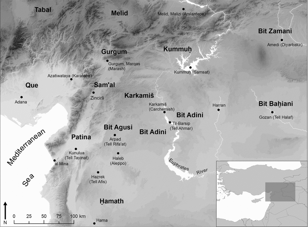
The collapse of the Hittite Empire of Late Bronze Age Anatolia in the early twelfth century BC led to a fragmented political landscape during the Iron Age I period in southern Turkey and northern Syria. These early Iron Age polities gradually became a complex and dynamic collection of city-states during the early first millennium, or Iron Age II (Figure 1). These Syro-Anatolian kingdoms survived until the mid–late eighth century BC, when they were conquered by the resurgent Neo-Assyrian Empire, at which time the Syro-Anatolian city-states effectively ceased to exist as a political or cultural phenomenon.
Map of the Syro-Anatolian city-states.

The capital cities of the Syro-Anatolian city-states were excavated extensively in the early decades of Near Eastern archaeology, with large sites such as Carchemish, Hamath, Malatya, Tell Halaf, Tell Tayinat and Zincirli all receiving massive horizontal exposures. As was typical of late-nineteenth- and early-twentieth-century excavations, this work focused almost exclusively on the remains from elite compounds: palaces, temples, statuary and other monumental arts, and royal inscriptions. All of these continue to play a vital role in how we understand the social dynamics of this time and place (Gilibert Reference Gilibert2011; Harmanşah Reference Harmanşah2013). The same bias applies to other large Syro-Anatolian cities that were not capitals per se, but that have impressive monumental remains, such as the spectacular temples at ‘Ain Dara (Abou Assaf Reference Abou Assaf1996) and Aleppo (Gonnella et al. Reference Gonnella, Khayyata and Kohlmeyer2005). This early research neglected not just rural life, but all those sectors of the cities occupied by non-elite residents. Furthermore, although understanding Iron Age socio-economic organisation has become as important as exposing monumentality, elite citadels remain the focus of the many renewed archaeological projects at these cities.
The typical Syro-Anatolian city comprises three topographical elements: a lower town, or settlement, usually at plain level; a citadel, or high mound, typically constructed on a pre-existing tell; and a palace compound situated at the highest point of the citadel; all of these were separated by fortification walls but connected by ascending streets through ceremonial gateways (Harmanşah Reference Harmanşah2013: 108–109). These elements of the city—fortifications, gates, human and animal statuary, palatial architecture—appear to have been tightly coordinated spatially as well as conceptually as a unified symbol of royal legitimacy (Osborne Reference Osborne2014). Yet, although our understanding of Syro-Anatolian capitals has become more sophisticated, their lower towns, presumably the location of the bulk of their populace, remain frustratingly underexplored. At Tell Rifa'at (ancient Arpad), for example, a huge outer city was mentioned in passing by the excavators (Seton-Williams Reference Seton-Williams1961: 70), who declined to investigate it. Indeed, it was all but forgotten until recognised in satellite imagery as an astonishing 120ha in size: the largest city in the Syro-Anatolian system (Casana Reference Casana2013: 261, fig. 4). This incomplete picture of Iron Age urbanism is in dire need of correction. This paper argues that, in the appropriate archaeological and geomorphological conditions, extremely high-resolution surface survey can provide a vast amount of information for broad sectors of ancient cities.
Ancient Kunulua and the Tayinat Lower Town Project
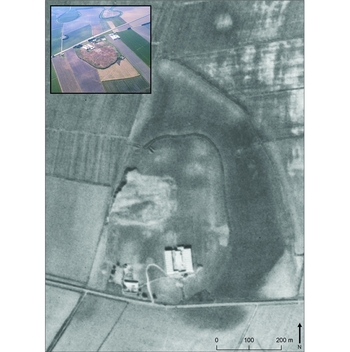
In 2014, the author launched the Tayinat Lower Town Project (TLTP), which seeks to shift attention away from the upper citadel of Iron Age cities and focus instead on their large lower settlements. Located in the Amuq Valley of southern Turkey, at the north-east corner of the Mediterranean Sea, Tell Tayinat is a low-lying 35ha site, of which roughly 16ha belong to the lower town. Today, this lies under the surface of the valley due to alluviation from the nearby Orontes River, only visible as discoloured soil in satellite imagery (Figure 2). Epigraphic discoveries have confirmed that Tell Tayinat was the ancient city of Kunulua, capital city of the Iron Age kingdom of Patina during the early first millennium BC.
Declassified Corona satellite image of Tell Tayinat with modern aerial photograph overlay. Note the invisibility of the lower town in the aerial photograph due to the alluviation of the nearby Orontes River (photograph by Murat Akar).

Tell Tayinat was excavated by the Oriental Institute of the University of Chicago in the 1930s (Haines Reference Haines1971). Part of a monumental gateway at the eastern edge of the lower town was exposed (Haines Reference Haines1971: 59–60), but otherwise the lower settlement was left unexplored. When work resumed in 1999, surface survey confirmed that the extent of the settlement roughly corresponded to the satellite imagery, and that on the basis of diagnostic ceramics (Batiuk et al. Reference Batiuk, Harrison, Pavlish and Yener2005), the entire lower town dated to the early first millennium BC (Iron Age II/III). Excavations conducted by the Tayinat Archaeological Project (TAP) since 2004 have uncovered impressive monumental remains from the Early Bronze Age and Iron Age II/III, as well as domestic architecture from the Iron Age I period, but the project did not move beyond the upper mound (Harrison Reference Harrison2009; Welton et al. Reference Welton, Batiuk and Harrison2011; Harrison & Osborne Reference Harrison and Osborne2012).
The TLTP was begun with the overall goal of directly exploring the archaeology of non-elite residents of capital cities. Planned excavations will address the specific objectives of a) understanding the processes of daily life during the early first millennium; b) craft specialisation in luxury goods traded across the Near East, whose specialists probably resided in the capitals (Winter Reference Winter1973, Reference Winter1983); and c) identifying evidence for the massive forced migrations that followed conquests by the Neo-Assyrian Empire (Oded Reference Oded1979). First, however, a broader programme of fieldwork was necessary to characterise the lower settlement of Tell Tayinat in broad terms, especially given the meagre attention these neighbourhoods have received. Specifically, TLTP began with a surface survey across the lower town to a) map settlement density as reflected by the differential concentration of artefacts; b) detect the presence of elite and non-elite neighbourhoods through analysis of find distributions; and c) determine differences in the functional use of space as indicated by the nature of the finds. This article presents results from two seasons at Tell Tayinat, and argues that high-density survey can be greatly informative regarding these aspects of urban life, further suggesting that Iron Age urbanism was a complicated phenomenon that varied between city-states.
Methods
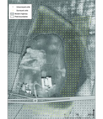
The surface of the 16ha lower settlement at Tell Tayinat is covered with a dense blanket of material culture, and so a probabilistic systematic sampling strategy was used to obtain a statistically valid estimate of the density of material across the settlement (Whallon Reference Whallon1979). We took collections from 10 × 10m units every 20m, resulting in 25 collection units per hectare, or 25 per cent of the total area surveyed. These units were placed on the coordinates of the pre-existing site grid in use by the TAP, which employs the Universal Transverse Mercator (UTM zone 37 north) coordinate system. Units were identified on the ground using handheld Garmin 62s GPS devices, which are usually accurate to under 350mm and rarely over 500mm. In total, 456 units were surveyed, including two large areas beyond the presumed northern and southern edges of the site to reconfirm that its areal extent matched that visible in the Corona image (Figure 3).
Tayinat Lower Town Project survey units.

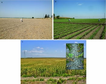
Three agricultural fields provided convenient survey areas: a fallow field south of the highway containing a small portion of the ancient settlement, a corn field to the north of the tell and a large cotton field on the east side that contained the bulk of the survey units. Visibility was extremely good: in the cotton field, survey took place before plants grew too large to obscure the ground, while in the corn field, survey was conducted after they had grown large enough not to impede walking or visibility at ground level (cf. Casana & Gansell Reference Casana, Gansell and Yener2005: 157, no. 35; Figure 4). Topographically, the lower settlement of Tell Tayinat is uniformly flat up to the edge of the upper mound, the northern and eastern edges of which have been scraped back by agricultural activity.
Surface conditions at the time of survey: A) the fallow field south of the modern highway (photograph by Megan Lewis); B) the east field with young cotton plants; C) the northern cornfield, with inset showing visibility at ground level (photographs by Rosanne Liebermann).

Adopting the collection methodology of the Tell Brak Suburban Survey (Ur et al. Reference Ur, Karsgaard and Oates2011), we derived two primary datasets from the collection units. The first comprised the total collection of artefacts from 2 × 2m squares in the south-west corner of each unit. Ceramics from these sub-units were counted and weighed as proxies for the density of the ancient settlement. The second dataset came from the remaining 96m2, from which only diagnostic ceramic sherds—rims, handles, bases and decorated body sherds—were kept in order to explore the functional use of space in the lower settlement. Dating and type attributions of each sherd were made according to a ceramic typology created by the author based on the excavations on the upper mound of the site (Osborne in press).
Intensive survey of large urban centres remains an uncommon practice, and this degree of resolution at a relatively large site ranks TLTP as one of the highest-resolution surveys of Bronze and Iron Age sites in the ancient Near East. The Tell Brak surface collection, for example, surveyed more units and collected more sherds, but across a much larger horizontal expanse and with a lower resolution (Ur et al. Reference Ur, Karsgaard and Oates2011: 3). Other site surveys in the Near East have similarly low resolution: Redman and Watson's random sampling surveyed only 10 per cent of Çayönü and Girik-i-Haciyan (Reference Redman and Watson1970: 281), and the survey of the lower town of the Neo-Assyrian site of Ziyaret Tepe used the same 10 × 10m collection unit but at a 2 per cent ratio (Matney Reference Matney1998: 9–10). Several site surveys have used methods that render their results difficult to compare: at Mashkan-shapir, a high-resolution survey collected objects but not ceramics (Stone & Zimansky Reference Stone and Zimansky2004: 43). Site topography also often dictates the use of ad hoc transect lines, especially when the primary research question is the areal extent of the site (e.g. Batiuk et al. Reference Batiuk, Harrison, Pavlish and Yener2005; Casana & Gansell Reference Casana, Gansell and Yener2005). The results might then be combined with larger arbitrary collection units for the purposes of better understanding diachronic site morphology (e.g. Peasnall & Algaze Reference Peasnall and Algaze2010: 169). Smaller sites present fewer challenges to intensive survey (Mazzoni et al. Reference Mazzoni, D'Agostino and Orsi2010), but even in these cases, TLTP had unusually high resolution and comprehensiveness.
The lower town at Tell Tayinat
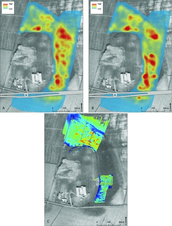
In total, TLTP collected 29667 sherds and 304 objects. The high number of sherds provides an extraordinarily robust sample reflecting the nature of the lower settlement at Tell Tayinat. Ceramic counts and weights for the sherds collected from the 2 × 2m units were mapped to show densities across the lower town. Artefact density between the collection units was determined using a kernel density extrapolation, with a quadratic formula estimating tapering values around known points according to an input radius parameter of 30m in order to approximate the diagonal distance between survey units spaced 20m apart (Figure 5A & B). For both counts and weights, clear patterns emerge, most prominently the expected confirmation of the edge of the ancient settlement aligning with the lower town's fortification wall visible in the Corona satellite image. This finding demonstrates the power of remote-sensing imagery for determining site size in alluvial environments. The lack of ceramic remains outside the edge of the settlement also serves as evidence that, as found in previous methodological studies (Rick Reference Rick1976; Ammerman Reference Ammerman1985), the surface pottery has not travelled significantly since the early first millennium BC, and thus can safely be used to interpret patterns in both the density of settlement and the functional use of space.
A) Kernel density extrapolation of ceramic sherds by count; B) kernel density extrapolation of sherds by weight; C) geomagnetic survey conducted by Charly Bank (with permission). Note the yellow line running east–west in the eastern sector of the geomagnetic survey. This line appears to connect gateway VII on the tell with gateway XI in the lower town, and may represent the magnetic signature of a stone-paved street identified in preliminary soundings in the 1930s (Haines Reference Haines1971: 60).

The data also reveal an uneven distribution of ceramic density across the settlement. Both count and weight show clear evidence of clustering, sharing multiple zones where they are disproportionately high. If surface ceramic density corresponds to the density of ancient occupation, it would appear that settlement in Kunulua's lower town was spatially uneven, with some areas particularly sparsely populated; for example, the north-western sector, a broad corridor in the north-east and a large area in the southern portion of the east field. The close similarities of both the count and weight extrapolations suggest that the two variables could be used interchangeably as estimates of ancient population density, although an additional large open space in the kernel density extrapolation of weight was driven by the lack of large storage vessels found in this area.
These sherd density clusters are spatially correlated with subsurface phenomena. A magnetometry survey of the lower town's northern sector and part of the eastern sector was conducted in 2010 by a team led by Charly Bank of the University of Toronto. As architecture at Tell Tayinat was constructed exclusively out of mud-brick without the use of stone foundations, remote-sensing surveys are unable to provide the detailed architectural plans produced at other Iron Age sites in the region such as Zincirli (Casana & Herrmann Reference Casana and Herrmann2010), Ziyaret Tepe (Matney & Bauer Reference Matney and Bauer2000) and Kerkenes Dağ. Areas with strong magnetic signatures are nevertheless visible. These may indicate the presence of monumental stone statuary, but their spatial correlation with surface pottery suggests rather that the magnetism is indicative of soils modified by anthropogenic activity. Strikingly, the areas with the strongest magnetic signatures—the red-coloured areas of the geomagnetic survey in the northern sector—align exactly with sherd weight and count density clusters, indicating in a few cases that even weak clustering of surface material is probably correlated with subsurface features (see Figure 5). In this case, the magnetic and surface ceramic data serve as independent verifications of each other's reliability, and together point towards these areas as having been densely settled neighbourhoods—prime locations for targeted excavations of architectural compounds. In addition, the magnetometry data indicate possible networks of streets, especially in the northern sector where several lines intersect immediately north of the tell, and in the south-east, where a distinct east–west line connects the locations of two gateways (VII and XI) excavated in the 1930s, and where limited soundings suggested the location of a stone-built road (Haines Reference Haines1971: 60).
The ceramic remains themselves date almost exclusively to the initial centuries of the first millennium BC (Iron Age), with just 1.2 per cent of the assemblage (n = 121) attributable to the late third millennium, or Early Bronze Age III and IV. These periods are mostly indicated at Tell Tayinat's lower town by Simple Ware, and a handful of Red Black Burnished Ware, sherds (Braidwood & Braidwood Reference Braidwood and Braidwood1960), the latter often used as the ceramic marker of the Early Transcaucasian Culture phenomenon (Batiuk Reference Batiuk2013). Similarly, 0.75 per cent of the sherds (n = 74) date to the Roman period, and probably derive from a small unmounded Roman-period villa immediately north of Tell Tayinat. That the Early Bronze Age sherds might actually represent settlement of that period in the lower town itself is indicated by the sherds’ spatial concentration in the northern quarter, including in areas over 100m from the tell, and are thus unlikely simply to have been eroded off the upper mound. With such small quantities, excavation will be needed to confirm settlement, and several metres of accumulated alluviation from the nearby Orontes River may explain why Early Bronze Age sherds do not appear in greater numbers on the surface.
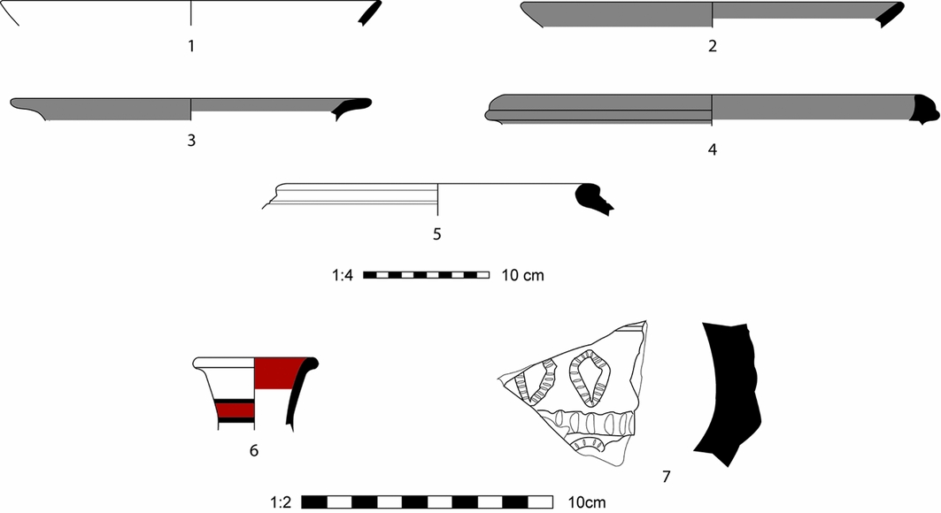
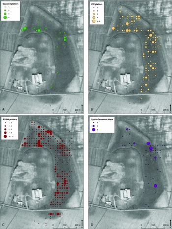
Aside from a handful of sherds that may be from the second millennium, the remainder of the assemblage belongs to the Iron Age II and III periods, roughly the ninth, eighth and seventh centuries BC (Figure 6). This pottery is characterised by large platters and a diverse array of bowl forms that appear in both Common Ware and Red Slipped Burnished Ware (RSBW), possibly a skeuomorph of the more prestigious bronze vessels that also exist in Iron Age capitals of the region. The rest of the assemblage, including cooking pots that are either stone-tempered hole-mouthed vessels or shell-tempered pots with outfolded rims, shares a number of characteristics with contemporary sites in northern Syria and south-eastern Turkey (Hausleiter & Reiche Reference Hausleiter and Reiche1999; Stone & Zimanksy Reference Stone and Zimansky1999). Platters with squared lips, purplish colouring and streaky burnishing, assumed (but not yet demonstrated stratigraphically) to derive from the beginning of the RSBW sequence around 900 BC (Swift Reference Swift1958), are predominantly located in the northern sector of the lower town, suggesting that settlement may have begun in this quarter before spreading to the lower town's full extent (Figure 7A).
Pottery from the TLTP survey discussed in the text: 1) Common Ware platter; 2) Red Slipped Burnished Ware platter; 3) Red Slipped Burnished Ware bowl with flat, everted rim; 4) Red Slipped Burnished Ware bowl with exterior thickened rim; 5) shell-tempered cooking pot; 6) Cypro-Geometric (Bichrome) Ware; 7) Assyrian stamped pottery.

Distributions of certain ware types across the lower settlement: A) early Iron II (c. 900 BC) platters; B) Common Ware platters; C) Red Slipped Burnished Ware platters; D) Cypro-Geometric (White Painted and Bichrome Ware) sherds.

RSBW's time-consuming and aesthetically pleasing surface treatment, as well as its resemblance to bronze, renders it a more prestigious version of its Common Ware equivalent. The stronger spatial clustering of RSBW platters in the lower town compared with the ubiquity of Common Ware platters may therefore indicate the locations of more elite residences (Figure 7B & C). The cluster of RSBW platters in the north-east next to the city wall, for example, aligns spatially with the most significant cluster of high-value Cypriot White Painted and Bichrome Wares from the contemporary Cypro-Geometric III period (Figure 7D), a strong indication of an elite residence or compound in this vicinity. Similar patterns exist elsewhere in the ceramic corpus, such as a clear spatial differentiation between RSBW bowls with flat, everted rims and those with exterior thickened rims (Figure 6.3 & 6.4); the significance of such findings is not yet certain.
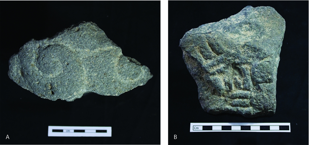
Although there are a small number of sherds that are definitely Assyrian, especially those stamped with Assyrian iconographic motifs, and a few pieces of possible Assyrian Palace Ware, there is little pottery that can be dated unequivocally to the period prior to the Assyrian takeover of the city in 738 BC, as the conquest of Tiglath-pileser III did not precipitate a significant change in local ceramic traditions. Two basalt statuary fragments, however, clearly derive from local traditions of monumental art dating to the tenth and ninth centuries or earlier (Orthmann Reference Orthmann1971). One is a piece of curly hair from the head of a colossal statue, and the other may be a fragment of dress (Figure 8). Both were found in the same survey unit, indicating the statuary's original ancient context in this area. Such finds indicate that the lower settlement of Kunulua was occupied both before and after the arrival of the Assyrians.
Pre-Assyrian, local Syro-Anatolian statuary fragments: A) hair fragment from a colossal statue; B) unidentified, possibly dress fragment? (photographs by Emily Booker and Steven Karacic).

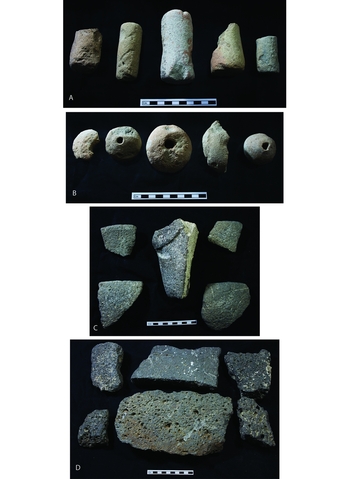
The 304 objects found in the survey, a significantly smaller dataset than the sherds, exhibit fewer patterns, and at lower resolution (Figure 9). By far the most common were fragments of basalt bowls and grinding stones, both of which were spatially ubiquitous. Worked and partially worked steatite and serpentine vessels were, however, concentrated in the eastern sector of the lower town, as were chert and flint blades and cores, suggesting that this district is where stone-working took place. A small number of indiscernible ivory fragments were also found in the vicinity, and if these too derive from the making of final products, then the eastern quarter may have been the area of production for a variety of craft specialties. By contrast, loomweights and spindle whorls clustered in two large neighbourhoods in the northern and eastern sectors.
Quotidian objects from across the lower settlement: A) cylindrical loom weights, or ‘spool weights’; B) tubular loom weights; C) basalt bowl fragments, including a tripod leg; D) grinding stone fragments (cf. Stone & Zimansky Reference Stone and Zimansky1999: figs 91–93; photographs by Emily Booker and Steven Karacic).

Comparisons and discussion
Very little modern archaeological attention has been paid to the non-elite lower settlements of Iron Age Syro-Anatolian capital cities. In some cases, such as Hama and Tell Rifa'at, the lower town lies underneath modern settlement, above which only the acropolis rises as a tell in the centre of the city. In others, excavation has taken place but has been restricted to the Neo-Assyrian period, as at Tell Ahmar (Jamieson Reference Jamieson2012), or has been comparatively small in scale and restricted primarily to public architecture, as at Tell Halaf and Carchemish (Woolley Reference Woolley1921; Naumann Reference Naumann1950), although in the case of Carchemish, a small number of houses were exposed (Woolley Reference Woolley1921: 118–32). One contemporary and morphologically similar site in south-eastern Anatolia is Ziyaret Tepe. Here, the lower town has been explored thoroughly with both surface collections (Matney Reference Matney1998) and magnetometry survey (Matney & Bauer Reference Matney and Bauer2000), as well as extensive excavation. In this case, however, the lower town appears to be an unambiguously Assyrian settlement, as indicated by, for example, courtyard buildings with pebbled mosaics (e.g. Matney et al. Reference Matney, Greenfield, Hartenberger, Keskin, Köroğlu, MacGınnıs, Monroe, Raınvılle, Shepperson, Vorderstrasse and Wıcke2009), similar to those found at Tell Ahmar.
The nearest Iron Age city to Tell Tayinat to have had its lower town surveyed is ‘Ain Dara, a roughly 17ha site located in the Afrin Valley, a tributary valley of the Amuq. Although not strictly the capital of a Syro-Anatolian kingdom like Tell Tayinat, its similar size and morphology render it a good basis for comparison. Here, surveyors collected diagnostic sherds from 50 × 50m units across the lower town, determining that it was occupied from the Late Bronze Age and into the early first millennium and later. Unlike the lower town at Tell Tayinat, ‘Ain Dara is a multi-period settlement, but as with Tell Tayinat, ‘Ain Dara seems to have been occupied across the entire city during the Iron Age II period, with two possible areas of greater density in the north-western and north-eastern quadrants of the site (Stone & Zimansky Reference Stone and Zimansky1999: 11, fig. 13). Small-scale preliminary excavations in these quadrants discovered domestic architecture of precisely the kind assumed to be present in the lower settlements of capitals, with many material parallels to Tell Tayinat (Stone & Zimansky Reference Stone and Zimansky1999: 23–58); regrettably, these excavations were ended prematurely.
Ultimately, across the Syro-Anatolian region, there is a dearth of comparative information about the nature of urban capital centres beyond the acropolis. The resulting impression has been that the Iron Age capital cities of southern Anatolia and northern Syria were exclusively occupied by the wealthiest and most politically powerful members of society, building their monumental art and architecture with very few people to impress in the urban centres themselves.
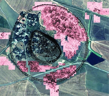
The major exception to the lack of empirical research into lower town dynamics of a proper Syro-Anatolian capital has been the large-scale remote sensing and excavations at Zincirli, Tell Tayinat's northern neighbour. In this case, the site's morphology—a lower town occupied by buildings immediately below the surface, and constructed using basalt stones with a strong magnetic signature for foundations—rendered it ideal for a large-scale magnetic gradiometry survey (Figure 10; Casana & Herrmann Reference Casana and Herrmann2010). This revealed a series of circular roads within a circular defensive wall, clearly constructed by central authorities, with its north-eastern quarter densely filled with buildings on a scale comparable with the palaces on the citadel. Even the apparently more cluttered area in the south-west may be present only as a result of modern agricultural practices (Casana & Herrmann Reference Casana and Herrmann2010: 68). Yet excavations in the lower town revealed a mortuary stele with a dedicatory inscription, a clear indication of elite-status individuals in this area (Struble & Herrmann Reference Struble and Herrmann2009). If Zincirli is representative of the Syro-Anatolian urban capital, these findings raise a profound question: if lower settlements are also filled with monumental architecture and statuary, then where did non-elite Syro-Anatolian residents live (Casana & Herrmann Reference Casana and Herrmann2010: 68)? One solution to this problem may be the discovery of earlier, non-elite, small and agglutinative buildings that were present at Zincirli before it was conquered by the Assyrians (Marom & Herrmann Reference Marom and Herrmann2014; Herrmann & Schloen Reference Herrmann, Schloen, MacGinnis and Wicke2016: 268), in which case, the magnetic survey results relate primarily to the Assyrian period.
Geomagnetic map of the lower town of Zincirli overlaid on the nineteenth-century excavation plan and modern satellite imagery (map made by Jason Herrmann, with permission of the Neubauer Expedition to Zincirli).

Results from the TLTP suggest that Zincirli's monumental and elite lower town may not, in fact, be representative of Iron Age capitals in the region. TLTP's survey and earlier geophysical work may not have provided as detailed an architectural plan of Tell Tayinat's lower town, but several lines of evidence indicate that it was occupied in a manner that was strikingly different from Zincirli. First, the clear spatial distinction between areas with dense occupation interspersed irregularly with sparsely occupied zones points to a lower settlement that was for the most part unplanned, with neighbourhoods growing over time and ultimately only occupying roughly half of the area within the city wall. Second, the concentration of RSBW in conjunction with high-value imported Cypro-Geometric pottery in specific locations suggests a lower town in which wealth was not distributed evenly across these neighbourhoods. The same is also implied by the negative correlation of domestic industry objects such as loom weights with these areas of valuable ceramics. Third, the spatial clustering of certain classes of objects, especially those involved in textiles, stone-working and ivory-carving suggests that craft specialisation may have been more highly localised than the uniform architectural layout of Zincirli seems to imply. Thus, the lower town at Tell Tayinat was probably occupied by a settlement that one would typically expect to encounter in such a context, and similar to the preliminary results from ‘Ain Dara: a diverse collection of actors and interest groups characterised by varying degrees of social status, including some elite households, but predominantly less wealthy and powerful than their neighbours on the acropolis.
Conclusions
The high-intensity survey performed by the TLTP has proven extremely effective at characterising, at least in broad strokes, a large area of settlement in a holistic and efficient manner. The success of this approach was dependent on the right morphological and archaeological conditions, including a highly constricted occupational history, a flat surface relatively unaffected by taphonomic processes, and spatially discrete clustering of artefacts that is demonstrably unchanged since the time of deposition. In the case of Tell Tayinat's lower town, the challenges of geophysical survey mean that architectural details remain unknown for now (pending experimentation with additional geophysical methods), but surface collections taken from 25 per cent of the 16ha lower settlement have compensated partially by providing a map of population density across the site and indicating how different sectors of the lower town were used by its occupants. Under similar circumstances, replicating this survey method elsewhere in the Near East could have a major impact on our understanding of urban centres.
TLTP's findings contribute significantly to the little we know about the lower settlements of Iron Age capitals in southern Anatolia and northern Syria. Although shared aspects of historical trajectory and material and visual culture, including urban symbolism, bring all of these Syro-Anatolian city-states into a shared cultural discourse, it is possible that the urban composition outside of the acropolis differed greatly in each of their capitals. Whereas Zincirli seems to have been characterised by large households in monumental buildings, the lower town of Tell Tayinat possessed a diverse and multifaceted array of social categories. If differences such as these are noted in other regional capitals when such research is conducted, then the inevitable conclusion will be that Near Eastern urban centres of the late second and early first millennia BC are resistant to characterisation under a convenient, single urban model.
Acknowledgements
The author extends his gratitude to Timothy Harrison, director of the Tayinat Archaeological Project, for his encouragement and support of the TLTP. The research presented here was conducted under the TAP excavation permits of 2014 and 2015, generously offered by Turkey's Ministry of Culture and Tourism. Funding for this work was kindly provided by the National Geographic Society (grant 9485-14) and the Wenner-Gren Foundation (grant 8963). Fieldwork was conducted by TLTP members Emily Booker, Ioana Dumitru, Megan Lewis, Rosanne Liebermann, Steven Karacic and Jill Waller.