Introduction
Yemen, lying at the tip of the Arabian Peninsula, borders the Red Sea to the west and the Indian Ocean to the south. Mountain ranges (>3500 m above sea level [asl]) run parallel to the Red Sea coast, coastal mountains border the Indian Ocean, while desert areas lie to the east and north (Fig. 1). Today, Yemen’s high plateaus and mountains receive significant rainfall, ranging from 300 to 1000 mm annually, primarily due to the Indian summer monsoon. Nevertheless, no lakes or ponds are present, for at present the evaporation far exceeds precipitation. Certainly, the area is sensitive to long-term moisture changes experienced during the Pleistocene and Holocene. The high mountain ranges may even have been subject to Pleistocene glaciation (El-Nakhal, Reference El-Nakhal1993). Thus, the Yemeni highlands have, potentially, been sensitive to both moisture and temperature fluctuations of the late Quaternary; to date, however, they remain relatively understudied (Davies, Reference Davies2006). This study aims to contribute to the understanding of climatic conditions in the Yemeni Highlands during the Holocene by investigating the biodiversity and distribution of freshwater ostracods. Two outcrops (Fig. 1) were investigated: one Bani Mattar Directorate, and the other on the Jahran plain (ASM4), south of Maba’ar Village (Fig. 2), and one in Al-Masajid Village (MASA) (Fig. 3). Both basins were shaped by rift systems, with the latter also characterized by volcanic activity (Geukens, Reference Geukens1966; Mattash et al., Reference Mattash, Pinarelli, Vaselli, Minissale, Al- Kadasi, Shawki and Tassi2013).
Locations of Al-Masajid Village (MASA) and Jahran Basin (ASM4).

Elevation map of mentioned localities in the Jahran Basin. Grey-scale colors indicate elevation (m asl).

Elevation map of in the Al-Masajid area. Grey-scale colors indicate elevation (m asl).

Climate evolution in Yemen
Groos et al. (Reference Groos, Akcar, Yesilyurt, Miehe, Vockenhuber and Veit2021) suggested that temperatures in the mountainous regions of East Africa during the Late Pleistocene were approximately 5 to 6°C lower than present-day temperatures. Glacier formation has been documented in various mountainous regions in East Africa above 3000 m asl (Groos et al., Reference Groos, Akcar, Yesilyurt, Miehe, Vockenhuber and Veit2021). In Yemen, El-Nakhal (Reference El-Nakhal1993) identified indications of glaciation and proposed the existence of glaciers in the highlands of Yemen citing Mitchell in Jado and Zötl (Reference Jado and Zötl1984).
Davies (Reference Davies2006) pointed out that climate in the plateaus of highland Yemen at the Pleistocene-Holocene transition changed considerably, based on samples taken in the Qa‘Jahran and Qa‘Shirah basins near the city of Dhamar. Her stratigraphical and chronological results showed high moisture levels in the Early Holocene, as indicated also by other archaeological and geological investigations (Wilkinson, Reference Wilkinson1997; Fleitmann, Reference Fleitmann, Burns, Mudelsee, Neff, Kramers, Mangini and Matter2003; Mayewski et al., Reference Mayewski, Rohling, Stager, Karlen, Maasch, Meeker, Meyerson, Gasse and Holmgren2004; Engel et al., Reference Engel, Brückner, Pint, Wellbrock, Ginau, Voss, Grottker, Klasen and Frenzel2012; Enzel et al., Reference Enzel, Kushnir and Quade2015).
This shift is attributable to the northward movement of the Intertropical Convergence Zone (ITCZ) during the Late Pleistocene and Early Holocene (Morrill et al., Reference Morrill, Overpeck and Cole2003). Consequently, the Indian summer monsoon brought increased precipitation to East Africa and the Arabian Peninsula, accompanied by a decrease in temperatures. During the Early and Middle Holocene, the landscape witnessed the development of lakes and marshes, indicating higher water availability, which has been attributed to reduced evaporation and increased precipitation (Wilkinson, Reference Wilkinson1997; Davies, Reference Davies2006). The landscape likely transitioned to a savanna-type vegetation cover (Wood, 1997, cited in Davies, Reference Davies2006).
Present conditions
Today, Yemen experiences a predominantly semi-arid to arid climate influenced by the southwest monsoon. Precipitation patterns vary significantly across the region. In the western part of the highlands at altitudes higher than 2000 m asl areas like Sana’a (Figs. 1 and 3) receive 200 to 600 mm annually, primarily from April to May and July to August, with mean temperatures ranging from 10 to 18 °C. Rainfall decreases towards the north, where temperatures can drop to freezing. In the eastern and central areas mean temperatures are higher, with significant day and night differences and frost occurs only occasionally. The sample site MASA is situated about 15 km west from Sana’a in the northern part of the highlands (Fig. 3), while ASM4 lies about 20 km north of Dhamar in the central part of the highlands (Fig. 2).
The western mountain range in Yemen spans approximately 450 km in a north-south direction and is 250 km wide. The peaks of these mountains reach heights of up to 3665 m (Jabal an-Nabi Schu‘aib) in the Sana’a governorate. The region is one of the most fertile areas in the Arabian Peninsula (Parker, Reference Parker, Petraglia and Rose2009). Agriculture remains the predominant economic activity, with crops such as grain, grapes, and fodder being cultivated. However, the recent expansion of khat cultivation has significantly displaced food crops. The remaining regions of Yemen are predominantly arid and hyper-arid, primarily used for livestock breeding, including sheep, dromedaries, horses, and cattle (Wilson, Reference Wilson2003).
Material and Methods
The study utilized sediment samples from two distinct stratigraphic sections: one located in Al-Masajid Village MASA (15°18ʹ34.76ʹʹN 44°4ʹ47.64ʹʹE) near Sana’a (Fig. 3) at an altitude of 2555 m asl, and the other in the Jahran Plain ASM4 (14°45ʹ2.70ʹʹN, 44°19ʹ27.20ʹʹE) (Fig. 2), at an altitude of 2323 m asl. A field trip was conducted in March 2019 to Al-Masajid Village, situated approximately 14 km from the center of Sana’a City, within a smaller basin inside the larger Sana’a Basin. Sediment samples were collected from a shallow well approximately six meters deep, dug by local residents, with 16 samples collected at intervals of 30 cm (Supplementary Fig. 4). The sediment composition consists of marl, peat, mollusks, shell remains of ostracods and rock fragments.
The Jahran Plain samples were collected during a field trip in November 2014, with a three-m-deep hole to gather the material, resulting in 31 samples at intervals of 5 and 10 cm from the grey marls and peat horizons. Data on sediments and ostracod associations for the second stratigraphic section in the Jahran basin were mainly taken from Mohammed and Keyser (Reference Mohammed, Keyser and Laith2021), with new isotopic and radiocarbon data added.
The sediment composition includes silty sediments, fine and coarse sands, coarse gravels, peat, and plant remains. Visual inspections of sediment lithology, grain size, color, sedimentary structures, and mollusk shell content were conducted for both sections.
Standard micropalaeontological techniques were applied to all samples (Moore, Reference Moore1961). For ostracod analysis, 200–250 g of unweathered sediment was taken, washed over a 200-mesh sieve (0.074-mm opening) to remove mud-sized sediment. Approximately 10 to 30 g of washed residue was extracted from each sample. Ostracod valves and carapaces were collected using a 00 brush under a stereomicroscope and placed into micro-slides. Scanning electron microscope (SEM) photos were taken at the Zoological Institute and Museum at Hamburg University with a SEM LEO 25. Specimens from Al-Masajid were deposited in the Leibniz Institute for the Analysis of Biodiversity Change in Hamburg (ZIM K-), while those from Jahran Plain were stored in the Department of Earth Sciences, Faculty of Petroleum and Natural Resources, Sana’a University (QJ), with SEM specimens also stored in the Leibniz Institute (ZIM K-). Morphological and systematic information on the collected ostracods is provided in the supplemental information (Supplementary Figs. 1–3).
Radiocarbon dating of well-preserved wood debris from the peat samples at 5.5 m depth in Al-Masajid Village was conducted at the Center for Mass Spectrometry Laboratory in Lithuania. Freshwater gastropod shells from two levels in the Jahran basin were collected for the new radiocarbon dating and analyzed in the Beta Analytic Radiocarbon Dating Laboratory in Miami, Florida. Radiocarbon results are given in Table 1 as calendar years before present (cal BP; calibration: BetaCal 3.21: HPD method: INTCAL20, no reservoir effect for aquatic material applied).
Radiocarbon data.

No reservoir effect for aquatic material applied.
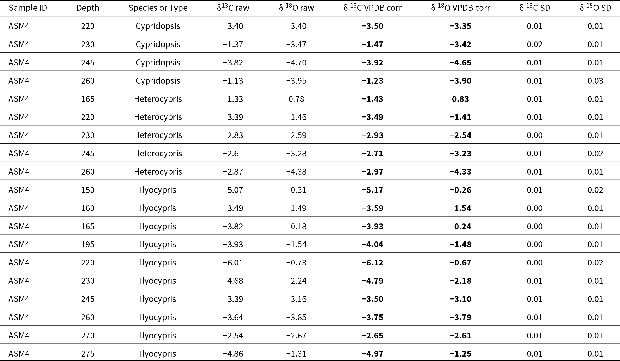
For stable isotope analysis, two to five ostracod valves each of three abundant species (Heterocypris salina, Cypridopsis vidua, Ilyocypris bradyi) were collected from the material of the stratigraphic section (ASM4) in the Jahran basin at depths 165, 220, 230, 245, and 260 cm for Heterocypris salina; 220, 230, 245, and 260 cm for Cypridopsis vidua; and 150, 160, 195, 220, 230, 245, 260, 270, and 275 cm for Ilyocypris bradyi. Ostracods were thoroughly cleaned and checked for adhering materials under a binocular microscope, then washed with distilled water for a few minutes and dried immediately after. The stable isotope analyses were performed in the Center for Marine Environmental Sciences, Isotope Chemistry in Bremen, Germany, using a ThermoFisher Scientific 253plus gas isotope ratio mass spectrometer with Kiel IV automated carbonate preparation device. The calculated standard deviation based on house standard (Solnhofen limestone) over the measurement period was 0.02‰ for δ13C and 0.06‰ for δ18O (Table 2).
Stable isotope signatures of some ostracod species.

Instrument: ThermoFisher Scientific 253plus gas isotope ratio mass spectrometer with Kiel IV automated carbonate preparation device.
Standard deviation of house standard (Solnhofen limestone) over measurement period:
0.02‰ for δ13C
0.06‰ for δ18O
Results
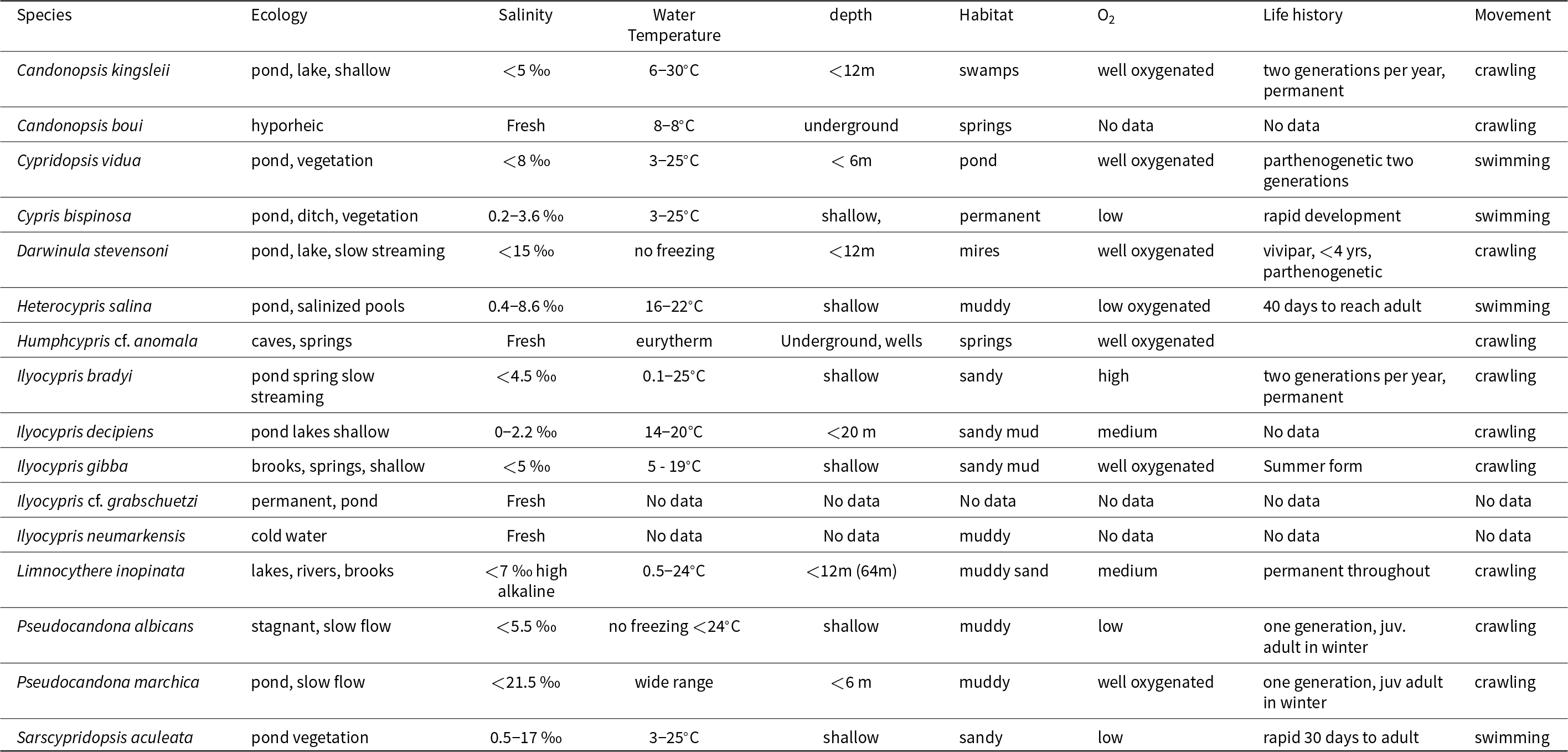
Ostracods were found exclusively in the marl layers of Jahran Plain and the silt sediments of Al-Masajid Village. Several of these species are known also from the African mountainous regions (Lindroth, Reference Lindroth1953; Löffler, Reference Löffler1968; Martens, Reference Martens1997). Others are distributed across the Palaearctic. Especially interesting is the appearance of different Ilyocypris species, which were originally described from the German Quaternary (Fuhrmann, Reference Fuhrmann2012). The ecological preferences are summarized in Table 3, and additional information is given in the supplementary information.
Ecological preferences of collected ostracod species compiled according to several authors (see also Supplemental Information).

Jahran Basin (ASM4)
The ASM4 section in Jahran Basin (300 cm) comprises gravelly fine sands (300–290 cm) overlain by a layer of grey marl approximately 160 cm thick, separated by a stratigraphic unconformity. The uppermost layer consists of valley sediment and modern soil, with dark gray horizons of organic-rich soils occurring at levels between 205–185 cm and 155–135 cm (Fig. 4).
Stratigraphic sections investigated for Ostracoda and mollusks: lithology and radiocarbon ages.

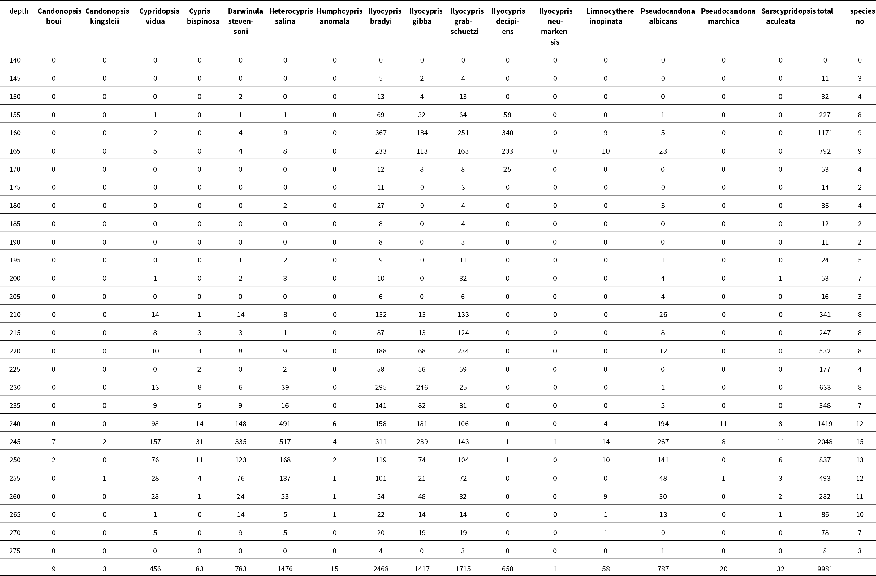
Ostracods were confined to the marl layers of Jahran Plain. They were notably abundant in sediments ranging from 270–205 cm and 170–150 cm, with a total of 16 species and 9980 valves of freshwater ostracods identified (Table 4 and supplemental information). Adult and juvenile ostracods were present in each of the samples. Therefore, an autochthonous population is assumed (Boomer et al., Reference Boomer2003). No ostracods were encountered in the lowest parts of the ASM4 section (280 cm to 270 cm) (Fig. 5). From 270 cm up to 260 cm, ostracods were present in low numbers but with relatively high diversity.
Distribution of ostracod species in section ASM4 with environmental stages indicated.

Species distribution and abundance in ASM4.

The highest diversity and abundance of ostracods were observed between 260 cm and 235 cm, followed by a reduction in diversity and abundance from 235 cm to 205 cm. Interestingly, a resurgence of high abundance, particularly of Ilyocypris and Limnocythere species, was noted in the 165 cm to 150 cm interval before diminishing again in the upper parts of the section (Fig. 5).
The most abundant species overall was Ilyocypris bradyi, accompanied by significant numbers of I. cf. grabschuetzi, I. gibba, and Heterocypris salina. Other species, such as Pseudocandona albicans, Darwinula stevensoni, Ilyocypris decipiens, and Cypridopsis vidua, were present in moderate abundance, while species such as Cypris bispinosa, Limnocythere inopinata, Sarscypridopsis aculeata, Pseudocandona marchica, and Humphcypris cf. anomala were found in lesser abundance. Candonopsis kingsleii and Candonopsis boui were rarely encountered (Fig. 5). Charophytes and/or mollusks are also present in some levels of the section.
Radiocarbon dating of mollusks from two levels (245 cm and 230 cm) yielded calibrated ages of 7594 ± 31 cal yr BP and 6933 ± 81 cal yr BP, respectively (Fig. 8, Table 1). A reservoir effect for the data was not calculated.
Stable isotope data revealed matching trends for δ13C and δ18O across all three species, with shifts of 1–4‰ (Fig. 7). The highest δ13C values for Ilyocypris bradyi were recorded at 270 cm (-2.5‰) and for Heterocypris salina at 165 cm (-1.5‰). An outlier to the δ13C trend occurs at 230 cm for Cypridopsis vidua and all taxa show low values at 220 cm. δ18O values were lowest between 260 cm and 245 cm for all species, with the highest value measured at 160 cm for Ilyocypris bradyi (Fig. 7, Table 2).
Al-Masajid Village (MASA)
The lowermost layer of the pit at Al-Masajid Village is a black peat, which was exposed from an unknown depth up to about 500 cm (Fig. 4). Above it lies a distinct layer (150 cm) of mixed coarse sand intercalated with a dark peat. This is followed by a transition from coarser sediments to finer ones in the subsequent 25 cm to a depth of 3.25 m. The subsequent 250 cm of the section comprises fine greyish brown to dark brown silty sediments, while the uppermost meter consists of a modern agricultural horizon of fine sandy silt loam, not included in sampling. A single sample of wood from the peat layer at level 550 cm was dated to 5657 ± 89 cal yr BP (Table 1).
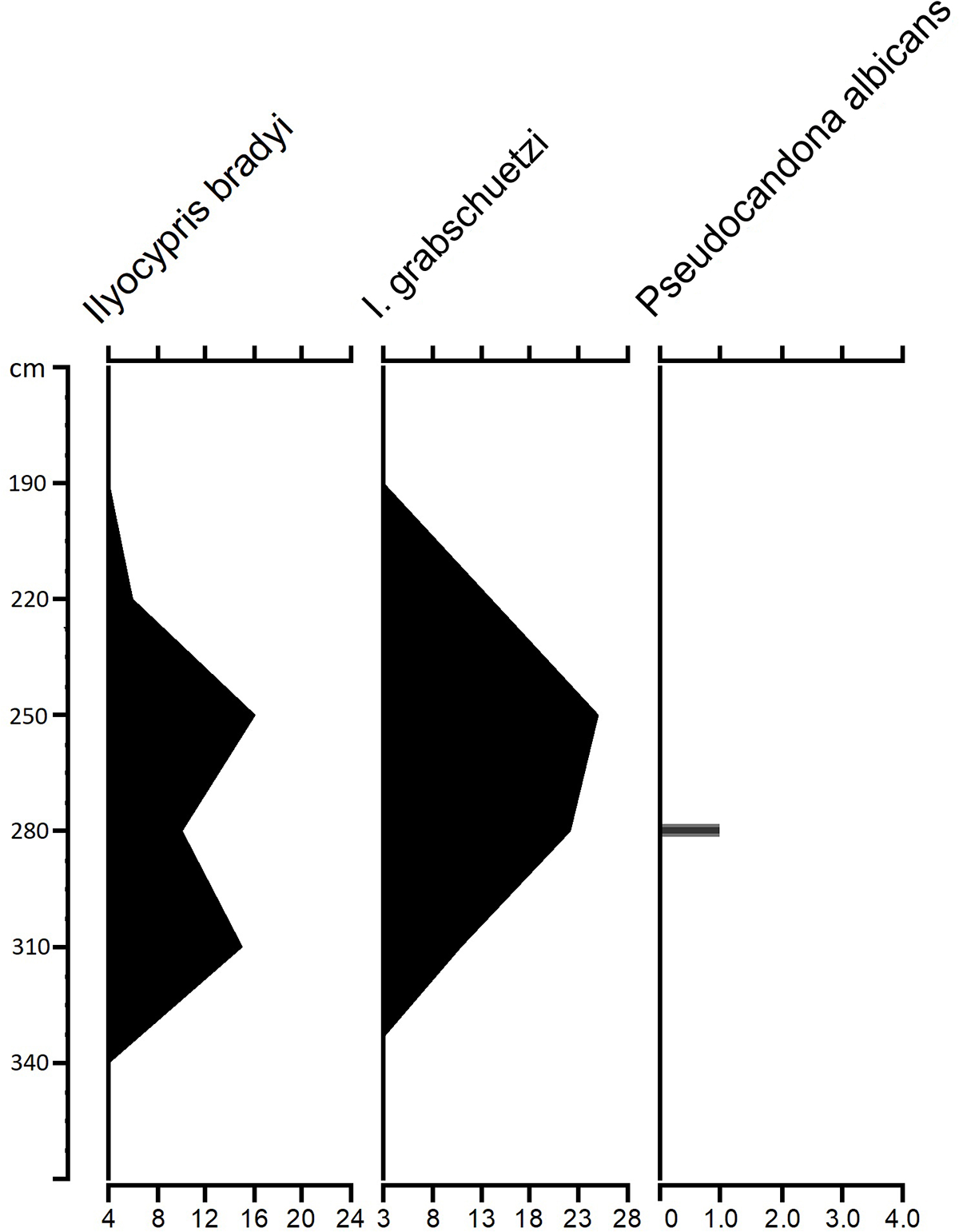
Only three species of ostracods were found together with oogonia of Characeae in low to intermediate abundance in the silty sediments between levels 190–310 cm (Figs. 4 and 6). The assemblage primarily consisted of adult of Ilyocypris bradyi and I. grabschuetzi, with the exception of a single juvenile valve of Pseudocandona albicans. The occurrence of mainly adult shells shows that this is an allochthonous population (Boomer et al., Reference Boomer2003).
Distribution of species in the MASA section.

Discussion
Chronology and Lithostratigraphy
The Jahran Basin (ASM4) section spans a period from the Early Holocene to about 3000 years BP. The Al-Masajid Village (MASA) section covers a narrower timeframe, ranging from 5500 years BP to about 3000 years BP (Figs. 8 and 9).
The lowermost part of the ASM4 section is characterized by a stratigraphic unconformity (Fig. 4). Davies (Reference Davies2006) and Parker et al. (Reference Parker, Davies and Wilkinson2006) interpreted the presence of gravels as remnants from the late-glacial period predating 10,000 cal yr BP. The overlying Holocene sediments indicate of a variety of mire, pond, and lake environments. Our lowermost radiocarbon date is ca. 7600 cal yr BP at 245 cm (Table 1). By extrapolating measured C14 ages with a consistent sedimentation rate, we estimate the age of the sample at 275 cm to be about 8950 cal yr BP, consistent with findings from other research (Lézine et al., Reference Lezine, Saliege, Robert, Wertz and Inizan1998; Davies, Reference Davies2006) and placing this sediment in the early Holocene (Fig. 9). Davies (Reference Davies2006) mentioned a “clear boundary” at this time between alluvial sands and overlying “lacustrine marl/marsh” in her nearest outcrop to ASM4 in Bayt Nahmi.
The basal sediment of the MASA section is peat dated to ca. 5660 cal yr BP (Fig. 4, Table 1). Only from ca. 190–319 cm are ostracods present, and the assemblage is species-poor and allochthonous. The following discussion is therefore focused on the Jaran Basin.
Jahran Basin (ASM4)
In ASM4, data on biodiversity and abundance of ostracod shells reveal six distinct stages. This classification aligns with the division into five units proposed by Mohammed and Keyser (Reference Mohammed, Keyser and Laith2021) (Fig. 5).
Stage 1 is notable for its absence of ostracods, with the gravelly fine sands being devoid of organic material. Given ASM4’s elevation at approximately 2300 m asl (Fig. 2) and the even higher sampling site of MASA at approximately 2600 m asl (Fig. 3), it is possible that these areas were influenced by regional glaciers and a cold climate during the Late Pleistocene, as suggested by Davies (Reference Davies2006), Parker et al. (Reference Parker, Davies and Wilkinson2006), and El-Nakhal (Reference El-Nakhal1993). With the onset of the stronger Indian monsoon in the Early Holocene (11,000 years BP), the cold and dry period at the end of the Pleistocene came to a close (Morrill et al, Reference Morrill, Overpeck and Cole2003). Seasonal conditions likely oscillated between cool, dry winters and moist, hot summers at these altitudes (El-Nakhal, Reference El-Nakhal1993). Melt from any remaining snowfields would have contributed to sandy and gravelly sediment transported by creeks and small rivers. The lack of organic material in these alluvial sands (Davies, Reference Davies2006) supports the view that the transporting water did not come from an area with abundant vegetation. At lower altitudes, however, the formation of small ponds and marsh areas may have occurred during this time interval.
Stage 2 marks an abrupt transition in ASM4’s lithology from sand and gravel to finer marls (Fig. 4), suggesting a warmer climate. As the distance to the source of coarse sediment supply grew and the current diminished, finer sediment was deposited in ASM4. The appearance of relatively few ostracods in Stage 2 (Fig. 5) suggests non-optimal conditions; possibly warming occurred slowly or was delayed at these high altitudes.
With a warming climate and stronger monsoon, available water increased, leading to the formation of ponds and small lakes. The low δ13C values (Fig. 7) suggest an increase in vegetation complexity and productivity. In the Early Holocene, possibly 9000-8000 yrs BP (extrapolated), the lowest δ18O values of Cypridopsis vidua, Heterocypris salina, and Ilyocypris bradyi occur (at about 260 cm). This phase likely represents the most humid period in the Holocene, supported by the records from Fleitmann et al. (Reference Fleitmann, Burns, Pekala, Mangini, Al-Subbary, Al-Aowah, Kramers and Matter2011) and Parker et al. (Reference Parker, Davies and Wilkinson2006). It marks the earliest evidence of wetland development in the section. While shells of I. bradyi, I. gibba, and P. albicans are reported from this depth, higher abundance and species diversity are observed in the upper part (270 cm, 265 cm), featuring ostracod assemblages including C. vidua, D. stevensoni, H. salina, H. cf. anomala, I. bradyi, I. gibba, I. cf. grabschuetzi, L. inopinata, P. albicans, and S. aculeata. These levels suggest the presence of fresh to oligohaline waters in a shallow lake or pond rich in vegetation, likely fed by streams.
Taxon abundance and stable oxygen and carbon isotope values of abundant ostracod species in section ASM4. Note scale changes on the x axis.

Stage 3 marks a significant increase in species diversity and abundance, reaching its peak at 245 cm, dating to 7594 ± 31 cal yr BP. However, diversity and species richness of ostracods decline in the uppermost part of the section at 240 cm. The pronounced diversity and abundance of ostracods in this stage suggest shallower fluvial waters and stable environmental conditions (Mischke, Reference Mischke2001). Most ostracods in this stage inhabit various habitats ranging from permanent waters to seasonally desiccated environments, but the presence of certain species such as D. stevensoni and Pseudocandona spp. is noteworthy due to their relatively long life-cycle, indicating a permanent water body (Meisch, Reference Meisch2000). The decrease in δ13C isotopic values indicates an increase in aquatic plant production, while δ18O data suggest a slight decrease in humidity, possibly due to reduced precipitation or increased evaporation. These levels likely represent a fresh to slightly brackish (low mesohaline) very shallow lake with dense vegetation.
Stage 4 saw a shift in waterbody productivity from oligotrophic to more eutrophic conditions, evidenced by a further decrease in δ13C and higher δ18O records indicating decreased humidity. Higher temperatures and a lower water table contributed to increased organic material production in the pond or lake, leading to a transition in vegetation to mire or swamp, ultimately resulting in a peat layer (Hirvus, Reference Hirvas, Kirjapaino and Vammala2006; Chambers et al., Reference Chambers, Booth, De Vleeschouwer, Lamentowicz, Le Roux, Mauquoy, Nichols and van Geel2012). Consequently, a reduction in part of the ostracod fauna occurred in this stage, as the water level dropped and the salinity increased. Furthermore, a slight increase in valves of the more salt-tolerant species C. vidua, D. stevensoni, H. salina, and P. albicans at a depth of 210 cm, indicates shallow, slightly saline, warm water with abundant submersed macrophytes (Meisch, Reference Meisch2000). Notably, species diversity decreased as species like C. boui, C. kingsleii, H. decipiens, L. inopinata, P. marchica, and S. aculeata completely disappeared. Ilyocypris spp., which also tolerate slightly oligohaline, slow-moving waters (Meisch, Reference Meisch2000), increase in richness in core depths between 250 cm to 210 cm.
The presence of high numbers of I. bradyi and I. gibba suggests fresh to oligohaline water with average pH values around or below 7.5 (Mezquita et al., Reference Mezquita, Griffiths, Sanz, Soria and Pinon1999; Mazzini et al., Reference Mazzini, Gliozzi, Rossetti and Pieri2014). The occurrence of a few shells of shallow-water species might be attributed to post-mortem transportation from littoral environments to slightly deeper waters. A gradual decrease in the number of I. bradyi and I. gibba and a noticeable increase in individuals of I. grabschuetzi at levels 225–210 cm could indicate a reduced discharge of water to the area (Fuhrmann, Reference Fuhrmann2012).
Stage 5, spanning from 205 cm to 175 cm, reflects a notable desiccation trend marked by a sharp decrease in the abundance of I. bradyi, I. cf. grabschuetzi, C. vidua, D. stevensoni, and P. albicans, and the absence of I. gibba. The scarcity of ostracod species in sediment samples at these depths suggests drier conditions. It is likely that the formation of dark soil in ASM4 and the peat layer in MASA, dating to 5657 ± 89 cal yrs BP (Fig. 8), occurred during this period. It is conceivable that the pond or lake dried up due to the weakening of the Indian monsoon at this time (Parker et al., Reference Parker, Eckersley, Smith, Goudie, Stokes, Ward, White and Hodson2004), which would have generated a more arid environment with hot summers and warm winters, high evaporation rates but less, possibly more sporadic, precipitation (Fleitmann et al., Reference Fleitmann, Burns, Mudelsee, Neff, Kramers, Mangini and Matter2003, Parker et al., Reference Parker, Eckersley, Smith, Goudie, Stokes, Ward, White and Hodson2004), resulting in nearly complete ostracod loss, with only occasional single valves of Ilyocypris found. Theses peat/soil horizons indicate terrain stability and the development of vegetated landscapes with sufficient moisture to support peat formation.
Age correlation of the studied sections. For lithological signatures see Figure 4.

Stage 6 features light marl sediment with highly weathered mollusks and distinct ostracod associations characterized by a notably high abundance of Ilyocypris spp. (I. bradyi, I. gibba, I. grabschuetzi, and I. decipiens) alongside low numbers of C. vidua, D. stevensoni, H. salina, P. albicans, and L. inopinata. At a depth of 170 cm, Ilyocypris species exhibit relatively low values, suggesting a significant increase in stream discharge into a newly formed lake in a wetter climate (Parker et al., Reference Parker, Eckersley, Smith, Goudie, Stokes, Ward, White and Hodson2004; Davies, Reference Davies2006,), which might have been connected with a strengthening of the Somali Jet (Funk et al., Reference Funk, Hoell, Shukla, Husak, Michaelsen, de Carvalho and Jones2016). A notable increase in valves of these taxa is observed in the overlying sediments (165–160 cm), indicating a steady rise in humidity. Mischke (Reference Mischke2001) interpreted the concurrent occurrence of L. inopinata with high abundance of Ilyocypris salebrosa and low ostracod diversity as indicative of a high lake level. Here, deeper lake conditions are inferred from the co-occurrence of L. inopinata and abundant Ilyocypris species, as well as the absence of complete mollusk shells. The presence of very few shallow water species is attributed to transportation from shallow environments to deeper waters. Subsequent shell reduction suggests a more arid environment, culminating in a complete absence of shells by the end of Stage 6.
Al-Masajid Village (MASA)
Although the section in MASA is relatively short it is nevertheless informative. The collected shells of two Ilyocypris species precisely match the distribution of Ilyocypris in ASM4. In ASM4 the higher concentration of Ilyocypris shells in Stage 6 ranges from 170 to 150 cm in the section, while in MASA this range is between 340 to 190 cm. The underlying peat layer in ASM4 is found between 200 and 170 cm whereas in MASA, it lies between 550 and 350 cm. These similarities in MASA samples and ASM4 (Figs. 6–8) suggest a widespread event in the northern highlands of Yemen during the last humid Mid-Holocene period, as noted by Davies (Reference Davies2006) and Parker (Reference Parker, Eckersley, Smith, Goudie, Stokes, Ward, White and Hodson2004, Reference Parker, Petraglia and Rose2009). The overlying 10-cm thick humus soil topped by thick calcrete sediments indicates long-term moisture persistence.
The ASM4 stratigraphy can be compared with previously published stratigraphies from the region by aligning dates (Fig. 9), which underscores the consistency of our findings with existing data.
Comparison of age determinations in various publications in relation to the present study.

The study has also contributed to the knowledge of Holocene freshwater ostracods in Yemen. Detailed information on ostracod taxonomy and occurrence is available in the supplementary information.
Conclusion
This study outlines a variable environment during the Holocene period within the highlands of Yemen. The detailed stratigraphic analysis of the Jahran Basin (ASM4) and Al-Masajid Village (MASA) sites provides valuable insights into the ecological dynamics, environmental, and climatic changes that occurred during the Holocene period.
Overall, these stages reflect the complex interplay between climate, water availability, and environmental changes during the Holocene in the Jahran Basin and surrounding areas. The possible late deglaciation and the early strengthening of the monsoon resulted in a series of unusual hydrological periods in the mountain basins. The presence or absence of ostracods serves as valuable indicator of these environmental shifts, providing insights into past aquatic ecosystems and climatic conditions. Additionally, the alignment of dating methods across different publications, as depicted in Figure 9, underscores the consistency of our findings with existing data while expanding upon them and providing new interpretive insights.
The geographical range of ostracod populations within Holocene water bodies in Yemen’s highlands is broad, including species known from African mountainous regions (Lindroth, Reference Lindroth1953; Löffler, Reference Löffler1968; Martens, Reference Martens1997), as well as those found in Europe and the broader Palaearctic region.
Supplementary material
The supplementary material for this article can be found at https://doi.org/10.1017/qua.2024.54.
Acknowledgements
Thanks are due to the CENAK and the Institut für Zell- und Systembiologie der Tiere (IZS) at the University of Hamburg for providing working space and facilities. Basim Al-Khirbash, dean of the Faculty of Petroleum and Natural Resources at the University of Sana’a, Yemen, deserves thanks for providing facilities for accomplishing the research in Hamburg. We owe a debt of gratitude to the University of Hamburg for providing financial support through the Scholars at Risk Program for Dr. Mohammed. We are also indebted to Ms. R. Walter, who provided the SEM photographs. Many thanks are rendered to David Horne, an anonymous reviewer, and Associate Editor Mary Edwards who gave much important advice for preparing the manuscript. For the improvement of the wording, we are indebted to OPENAI ChatGPT.3.5.