INTRODUCTION
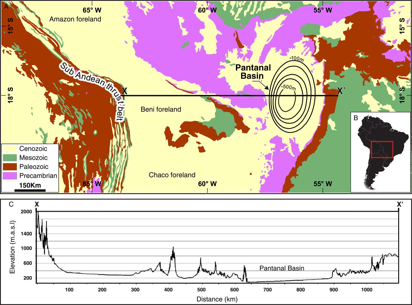
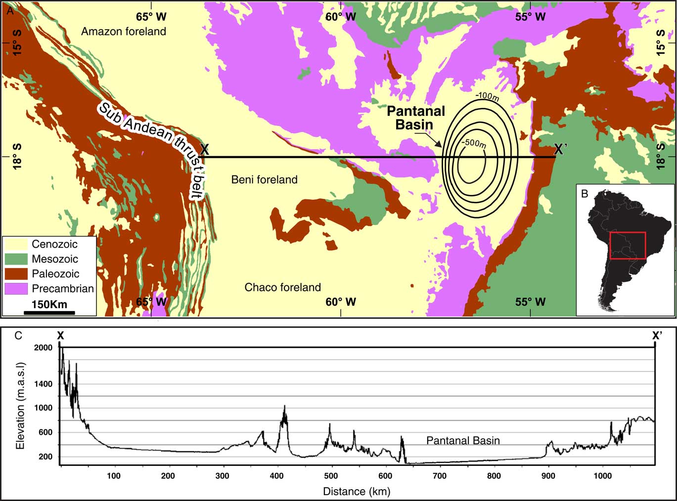
The Pantanal forms one of the most important inland wetland ecosystems in tropical South America (Costa et al., Reference Cohen, McGlue, Ellis, Zani, Swarzenski, Assine and Silva2015). Fed by monsoon rainfall and the flooding of the Upper Paraguay River and its tributaries, the Pantanal is the world’s largest freshwater wetland, covering an area of >130,000 km2 at peak inundation (Fig. 1) (Hamilton, Reference Hamilton, Sippel, Calheiros and Melack2002). Although “Pantanal” is derived from the Portuguese word for swamp (pântano), this region is far more heterogeneous than the name implies and includes habitats that are rarely or never immersed in floodwaters (Silva and Abdon, Reference Seidl and Moraes1998; Junk et al., Reference Hua, Barbetti and Rakowski2006; Rezende-Filho et al., Reference Quénol, Fort, Barbiero and Sakamoto2012). Thus, the Pantanal is best described as a wetland mosaic, which is characterized by different climatic, hydrologic, and topographic gradients. Evans and Costa (Reference Dunagan and Turner2013) put these environmental gradients forward as primary controls on floral and faunal diversity in the basin.
Overview map of the Quaternary Pantanal basin in tropical South America (modified after Assine et al., Reference Assine, Merino, Pupim, Azevedo Macedo and Santos2015b). (A) Generalized geology of central South America. The Pantanal is ~650 km from the Andean thrust front. Contours (m) reflect depth to basement, illustrating the shallow nature of the basin, which makes it susceptible to widespread flooding and wetland development. (B) Inset map of South America. Red box marks the approximate location of panel A. (C) Topographic profile (X–X’ of panel A) derived from SRTM90 (Shuttle Radar Topography Mission 90) elevation data across the Pantanal highlights the gentle east-to-west gradient that defines the lowland basin.
Modern patterns of biodiversity within the Pantanal are complicated by the presence of ancient floodplain landforms; the spatiotemporal development of many of these features remains understudied (Assine et al., Reference Assine, Merino, Pupim, Warren, Guerreiro and McGlue2015c). Sediments from the São Lourenço and Paraguay megafans provide evidence that Quaternary climate change influenced fluvial channel patterns and styles of floodplain deposition, but chronological control from these settings is somewhat limited (Fig. 2) (Assine and Silva, Reference Assine and Silva2009; Assine et al., Reference Assine, Corradini, Pupim and McGlue2014; Pupim et al., 2017). Sediment cores from floodplain lakes of the central Pantanal record profound changes in climate, vegetation, and surface processes in the late Pleistocene and Holocene (Whitney et al., Reference Ward2011; McGlue et al., Reference Mariot, Dudal, Furian, Sakamoto, Vallès, Fort and Barbiero2012), whereas the few archive records available from the drier southern Pantanal are more difficult to interpret, in part because of coarse temporal resolution and the potential for discontinuous sedimentation (Victoria et al., Reference Tripaldi and Zárate1995; Kuerten et al., Reference Klammer2013). This knowledge gap represents a challenge to fully understanding the form, function, and history of the Pantanal ecosystem and the evolution of its biodiversity.
Map of the Pantanal wetlands (modified after Assine et al., Reference Assine, Merino, Pupim, Azevedo Macedo and Santos2015b). Note the prominence of fluvial megafans within the basin (numbered at left). Nhecolândia is located south of the Taquari River on an abandoned megafan lobe. A red box marks the approximate location of the saline lakes analyzed in this study. (For interpretation of the references to color in this figure legend, the reader is referred to the web version of this article.)

One plausible archive of Quaternary environmental history resides in the deposits of more than 10,000 shallow lakes of Nhecolândia, one of the Pantanal’s most iconic and biodiverse landscapes. Nhecolândia is the southern geomorphic subunit of the Taquari River megafan, and this region’s lakes have fascinated scientists for decades (Fig. 2) (Assine, Reference Assine2005). Early geomorphological research in Nhecolândia focused on lake shape, long-axis azimuth, density, and the presence of fringing sand ridges (locally known as cordilheiras), which prompted hypotheses that linked the origins of these lentic ecosystems to deflation during glacial intervals (Klammer, Reference Kanner, Burns, Cheng, Edwards and Vuille1982; Tricart, Reference Thompson, Davis, Mosley-Thompson, Sowers, Henderson, Zagorodnov and Lin1982; Assine et al., Reference Assine, Merino, Pupim, Warren, Guerreiro and McGlue2015c). According to this hypothesis, hollows scoured into the floodplain by wind during periods of dry climate ultimately develop into lakes (pans), when a transition to humid conditions allowed for groundwater discharge to fill the shallow accommodation. In this context, the cordilheiras were hypothesized to reflect the buildup of downwind lunettes. Although not universally accepted (Wilhelmy, Reference Whitney, Mayle, Punyasena, Fitzpatrick, Burn, Guillen, Chavez, Mann, Pennington and Metcalfe1958; Ab’Saber, Reference Ab’Saber1988), this model of lake formation has been disseminated in the literature, despite an absence of sedimentary ground truth (e.g., Clapperton, Reference Buehler, Weissmann, Scuderi and Hartley1993).
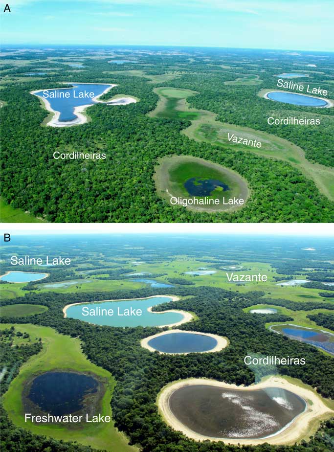
The paucity of sedimentary data from Nhecolândia’s lakes contrasts with relatively abundant water chemistry information, which shows substantial variability (Barbiéro et al., Reference Barbiéro, de Queiroz Neto, Ciornei, Sakamoto, Capellari, Fernandes and Valles2002; Bergier et al., Reference Barbiero, Rezende Filho, Furquim, Furian, Sakamoto, Valles, Graham, Fort, Ferreira and Neto2014). Freshwater (weakly alkaline), oligosaline (moderately alkaline), and saline (strongly alkaline) lakes are juxtaposed in close proximity in Nhecolândia; the distance between freshwater and saline lakes can be on the order of tens of meters (Fig. 3). Identifying a causative mechanism for this hydrochemical heterogeneity has been a key research objective in Nhecolândia. Furian et al. (Reference Freytet and Plaziat2013) discovered that with evaporation, water from the Taquari River concentrates into a similar chemical composition as the saline lakes of Nhecolândia. Those authors argued that spatial differences in lake salinity may have arisen because of variability in surface and groundwater flow paths, governed by shallow soils that act as confining layers (Barbiero et al., Reference Barbiero, Rezende Filho, Furquim, Furian, Sakamoto, Valles, Graham, Fort, Ferreira and Neto2008; Furquim et al., Reference Furquim, Graham, Barbiéro, Neto and Vidal-Torrado2010b). In other words, where floodplain depressions experience groundwater inflow during the wet season, but outflow is restricted by chemically cemented soils, saline lakes have the potential to evolve via evaporation of the restricted brines. These results have largely dispelled the notion that a saline aquifer discharges solute-laden groundwater to the pans, as had been suggested by Tricart (Reference Thompson, Davis, Mosley-Thompson, Sowers, Henderson, Zagorodnov and Lin1982).
Overflight photographs of the Nhecolândia, illustrating major landforms and close proximity of lakes of diverse hydrochemistry. Saline ponds are marked by blue-green water, white beaches, and trees on adjacent cordilheiras (low-relief sandhills). Freshwater ponds have more diffuse margins and contain abundant rooted and floating macrophytes. The freshwater lakes frequently become integrated into vazantes with the arrival of summer rainfall. (For interpretation of the references to color in this figure legend, the reader is referred to the web version of this article.)

The hydrogeologic model of Furian et al. (Reference Freytet and Plaziat2013) predicts that freshwater lakes can evolve into saline lakes via evaporation, assuming that cemented soil horizons build up to sufficient heights to maintain subsurface hydrologic closure. However, this prediction cannot be tested through modern water and soil sampling alone. In this study, we use sediment cores to clarify the timing and environmental context of saline lake development in Nhecolândia. Neither the composition nor the texture of saline lake sediments is well known, and the rates of accumulation have yet to be fully examined. We used radiocarbon and optically stimulated luminescence (OSL) dating, lithostratigraphy, particle size, and bulk geochemistry to determine the potential of Nhecolândia saline lake sediments as paleolimnological archives and provide new evidence for Holocene changes in depositional environment in the biodiverse southern Pantanal. The results also shed new light the geomorphic evolution of pans in Nhecolândia.
STUDY AREA
The Pantanal basin
The Pantanal wetlands occupy a low-altitude, spoon-shaped sedimentary basin that spans the borders of Brazil, Bolivia, and Paraguay (~16–21°S, ~55–58°W) (Fig. 1). The existence of the wetlands can be traced to Andean tectonics and the annual flooding cycle of the Upper Paraguay River (Hamilton et al., 1997). Crustal flexure associated with growth of the Andes created the shallow Pantanal basin, which is essentially filled to capacity with alluvium (Horton and DeCelles, Reference Holliday, Hovorka and Gustavson1997; Assine et al., Reference Assine, Merino, Pupim, Warren, Guerreiro and McGlue2015c). Topography and relief are minimal over large parts of the basin, rendering the Pantanal particularly susceptible to flooding with the arrival of monsoon rainfall and the rising stage of the Upper Paraguay River (Hamilton et al., Reference Hamilton, Sippel, Calheiros and Melack1997, Reference Hamilton, Sippel, Calheiros and Melack2002). The Upper Paraguay River flood pulse is the cause of widespread inundation that governs complex floodplain biogeochemical cycling and a host of ecological processes, including (a) fish spawning cycles, (b) rookery development, (c) avian migration patterns, and (d) predator-prey interactions (Por, Reference Parteli, Schwämmle, Herrmann, Monteiro and Maia1995). Seven large-scale distributive fluvial systems form prominent depositional environments in the Pantanal today (Assine et al., Reference Assine, Merino, Pupim, Azevedo Macedo and Santos2015b, Reference Assine, Merino, Pupim, Warren, Guerreiro and McGlue2015c); the best studied is the vast Taquari River megafan, which is situated near the geographic center of the basin (Assine, Reference Assine2005; Porsani et al., Reference Por2005; Buehler et al., Reference Blaauw and Christen2011; Makaske et al., Reference Luna, Parteli and Herrmann2012; Zani et al., Reference Wilhelmy2012).
Nhecolândia
Nhecolândia (~24,000 km2) is a fossil distributary lobe of the Taquari River megafan that sits ~50 km southwest of the actively meandering river (Assine and Soares, Reference Assine and Soares2004; Assine et al., Reference Assine, Merino, Pupim, Warren, Guerreiro and McGlue2015c). Nhecolândia is defined by the presence of lakes, which are individually very small (<1.0 km2) but occupy a total area of ~8000 km2 (Fig. 2). The margins of the saline lakes are surrounded by the sandy low-relief cordilheiras, which are commonly covered in wooded savanna vegetation (Fig. 3) (Pott et al., Reference Porsani, Assine and Moutinho2011). The lakes are interspersed among seasonal floodwater courses (vazantes) and permanent channels (corixos) (Fig. 3).
We focused our study on three saline lakes (Salina da Ponta, Salina Babaçu, and Salina Máscara) in northwest Nhecolândia (Fig. 4). These saline lakes are typical of the region—they are small (0.1–0.3 km2), oval to elongate in shape, and shallow (Z max 2–3 m). Green surface waters are common in the saline lakes because of cyanobacteria blooms (Bergier et al., Reference Barbiero, Rezende Filho, Furquim, Furian, Sakamoto, Valles, Graham, Fort, Ferreira and Neto2014). The pH of these lakes is high (9.4–10.0), and electrical conductivity varies from 556 to 5790 S/cm (Almeida et al., Reference Almeida, Paranhos Filho, Rocha, Souza, Sígolo and Bertolo2009; Malone et al., Reference Makaske, Maathuis, Padovani, Stolker, Mosselman and Jongman2013; Costa et al., Reference Cohen, McGlue, Ellis, Zani, Swarzenski, Assine and Silva2015). Prior research has shown that in the austral winter, complete desiccation is unusual for many of the saline lakes, though it is common for the margins to become dry, mud cracked, and bioturbated (Sakamoto, Reference Rojas, Arias, Flores-Aqueveque, Seth and Vuille1997; Barbiero et al., Reference Barbiero, Rezende Filho, Furquim, Furian, Sakamoto, Valles, Graham, Fort, Ferreira and Neto2008; Furquim et al., Reference Furquim, Barbiero, Graham, de Queiroz Neto, Ferreira and Furian2010a). The character of nearby freshwater lakes is very different. These lake basins contain dark-colored surface waters and a carpet of floating macrophytes (Bergier et al., Reference Barbiero, Rezende Filho, Furquim, Furian, Sakamoto, Valles, Graham, Fort, Ferreira and Neto2014). Many of the freshwater lakes become integrated in vazantes during the austral summer floods, but the surrounding cordilheiras limit the influence of this process on the saline lakes (Costa et al., Reference Cohen, McGlue, Ellis, Zani, Swarzenski, Assine and Silva2015).
(A) Landsat Thematic Mapper image of northwest Nhecolândia. Salina da Ponta (core NM1) is located on Fazenda Nhumirim, whereas Salinas Babaçu (core NM3) and Máscara (core NM4) are located along a 20 km transect oriented northeast–southwest. Green areas represent the irregularly shaped, vegetation-covered cordilheiras. A prominent vazante is situated to the north of Salinas da Ponta and Babaçu. (B) Simplified core logs of the upper 160 cm of NM1, NM3, and NM4, with radiocarbon and optically stimulated luminescence (OSL) chronological control points. Each lake’s shallow stratigraphy is composed of two lithostratigraphic units, which capture a transition in depositional environment. (For interpretation of the references to color in this figure legend, the reader is referred to the web version of this article.)

The climate of the Pantanal is controlled by the South American summer monsoon (SASM), which delivers moisture from the tropical Atlantic Ocean and the Amazon basin to the continental interior lowlands. Importantly, Nhecolândia is isolated from the direct influence of Upper Paraguay River flooding. Similarly, Nhecolândia does not receive water directly from the Taquari River (Assine et al., Reference Assine, Macedo, Stevaux, Bergier, Padovani and Silva2015a), and the majority of lakes in the region are isolated from the rising stage of the Negro River (Fig. 2). Rather, Nhecolândia’s hydrology is most sensitive to direct rainfall, local flooding, groundwater table elevation, and evapotranspiration. The groundwater is shallow in Nhecolândia, with seasonal variations on the order of 1–3 m. The climate of Nhecolândia is tropical semihumid, with an average annual temperature of 25°C. The majority of the annual rain (~1100 mm) falls during the austral summer months. Annual evapotranspiration estimates reported for Nhecolândia are ~1400 mm, which defines a negative water balance of ~300 mm (Furian et al., Reference Freytet and Plaziat2013). Quénol et al. (Reference Pupim, Assine and Sawakuchi2006) report that a diurnal thermal contrast develops between the saline lakes and the cordilheiras, which may generate winds that serve to increase evaporation rates locally.
METHODS
Salina da Ponta (core NM1) is located on Fazenda Nhumirim, an experimental farm operated by the Brazilian Agricultural Research Corporation (EMBRAPA) (Fig. 4). Salina Babaçu (core NM3) and Salina Máscara (core NM4) are <20 km northeast of Fazenda Nhumirim. The sediment cores were collected using a vibrocorer, sealed in the field, and transported to São Paulo State University for initial core description (ICD) and subsampling. Smear slide analyses conducted as part of the ICD were later supplemented by both random powder and oriented X-ray diffraction (XRD) techniques, in order to help assess mineralogy.
Geochronology
Twenty sediment subsamples from the three cores were sieved to separate <63 μm organic matter for radiocarbon (14C) dating (Table 1). The acid-insoluble fraction was analyzed by accelerator mass spectrometry at Beta Analytical Inc. Radiocarbon age-depth models for cores NM1 (n=9) and NM3 (n=7) were developed using Bacon software and the SHCal13 and SH3 calibration curves (Blaauw and Christen, Reference Bird, Abbott, Rodbell and Vuille2011; Hogg et al., Reference Hillyer, Valencia, Bush, Silman and Steinitz-Kannan2013; Hua et al., Reference Horton and DeCelles2013). Bacon estimates sediment accumulation rates through Monte Carlo Markov chain (MCMC) iterations. In Table 1, we report the 2σ range and median probability of calendar year ages before present (AD 1950) produced by Bacon. Core NM4 did not yield enough dated horizons to generate a viable Bacon model, so we calibrated available 14C ages using CALIB 7.1 (http://calib.qub.ac.uk/calib/) and CALIBomb (http://calib.qub.ac.uk/CALIBomb/).
Radiocarbon dates for NM1, NM3, and NM4. Calibrated ages for NM1 and NM3 were derived from the Bacon age-depth model. Dates for NM4 were calibrated using CALIB 7.1 and CALIBomb. SOM, sedimentary organic matter. pMC, percent Modern Carbon.

OSL dating was performed on two samples (one each from NM1 and NM3) using the single-aliquot regenerative dose protocol for quartz grains (Murray and Wintle, Reference Mourão, Ishii and Campos2000) at the Luminescence and Gamma Spectrometry Laboratory at the University of São Paulo (Table 2). Additional details on sample preparation and analytical protocols for OSL are found in the Supplementary Text and Supplementary Table 1.
Sediment size and composition
Cores were subsampled along their length every 5 to 10 cm for terrigenous particle size, total inorganic carbon (TIC), and total organic carbon (TOC) analysis (Supplementary Table 2). Following chemical pretreatment to remove biochemical components, the particle-size distribution of each sample was measured in triplicate on a Malvern Mastersizer laser diffraction particle-size analyzer at the University of Kentucky. Samples were dispersed, shaken, and sonicated prior to measurement. Values reported in Supplementary Table 2 reflect the average % sand (>63.5 μm), % silt (2.0–63.5 μm), and % clay (<2.0 μm) of the three measurements. Particle-size data were used to provide insight on sedimentary processes and help define depositional environment. Carbon content was determined at the Kentucky Geological Survey using a UICTM carbonate coulometer and a LECO device. TOC was calculated as the difference between total carbon and TIC. The precision of these analyses was ±0.2%. We also analyzed organic-rich samples for biogenic silica (BiSi) and total nitrogen (TN). BiSi was measured at Northern Arizona University using the method of Mortlock and Froelich (Reference Meyers and Ishiwatari1989). The standard uncertainty, based on replication of unknowns and an internal standard, was better than ±1.0%. Sedimentary TN was measured at the University of Utah using an elemental analyzer. The standard uncertainty, based on analyses of internal standards, was ±0.2%. C/N values were calculated from TOC derived from the LECO analysis and TN derived from elemental analysis; results are presented as atomic ratios. Sedimentary TOC, TIC, TN, C/N, and BiSi data were used to inform interpretations on depositional environment, paleoproduction, and the provenance of organic matter (Meyers and Ishiwatari, Reference Metcalfe, Whitney, Fitzpatrick, Mayle, Loader, Street‐Perrott and Mann1993).
RESULTS
Lithostratigraphy and particle-size trends
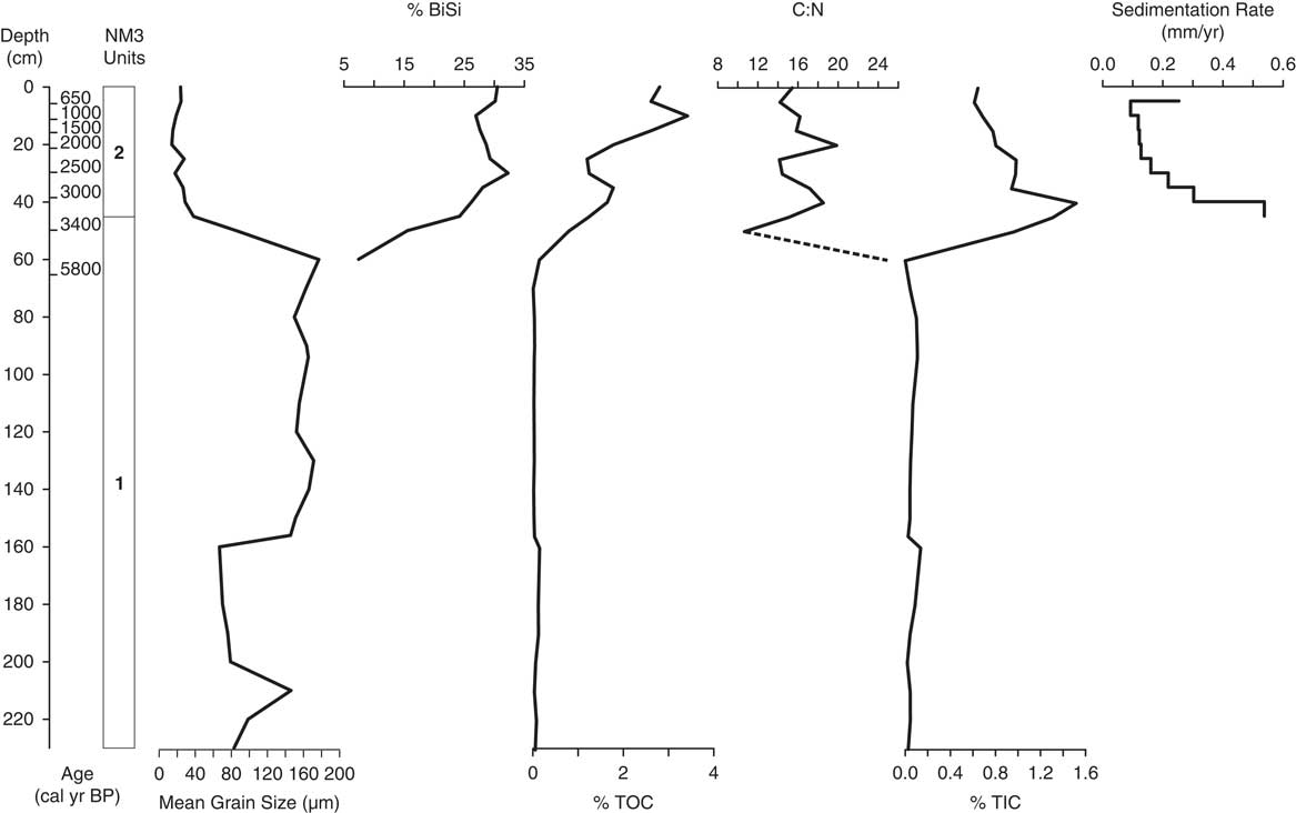
The stratigraphy of the three cores was similar and defined by two units separated by a relatively sharp contact (Fig. 4). Basal unit 1 consisted of tan, massive, very fine to fine sands with occasional indurated layers of green clayey sand. XRD data showed that the tan unit 1 sands are quartz rich and approximately monomineralic. The green indurated sands were likewise dominated by quartz but also included several clays (illite, R1-ordered mixed layer illite/smectite with approximately 20% smectite, kaolinite, and trace chlorite, in rank order of abundance) and carbonate (Fig. 5). Mean unit 1 particles sizes were ~157, 126, and 124 µm for NM1, NM3, and NM4, respectively. Unit 1 in NM1 and NM3 displayed fining upward patterns and were increasingly silt and clay rich below the unit 2 contact (Figs. 6 and 7). Unit 2 deposits consisted of dark-green to brown massive muds. Smear slides and XRD indicated that the muds consisted of quartz, K-feldspar, clays (dominantly illite with trace kaolinite), carbonates (including calcite, minor dolomite, and traces of ferroan dolomite), traces of gypsum, and abundant diatom and sponge microfossils (Fig. 5). Mean unit 2 particles sizes in NM1 and NM3 were ~34 and 29 µm, respectively, whereas unit 2 deposits in NM4 were slightly coarser (mean=~84 µm).
(color online) Whole sample powder (large traces, 5–65°2θ, at bottom) and <4 μm ethylene glycol-solvated (small traces, 2–36°2θ, at upper right) X-ray diffraction patterns from representative unit 2 muds and unit 1 sands in NM1 and NM3. Oriented air-dried (not shown) and glycolated traces were used to identify clay minerals. Bar charts reflect quantified mineralogy. A, amorphous; Ca, calcite; D, dolomite; FD, ferroan dolomite; G, gypsum; KF, potassium feldspar; P, plagioclase; Q, quartz; Tphy, total phyllosilicates. Unit 2 samples dominantly reflect a mixture of quartz, organic matter, illite, and carbonates. (A) Traces from unit 2 muds in NM1 at 5 cm. (B) Traces from unit 2 muds in NM1 at 15 cm. (C) Traces from NM3 at 160 cm. Most unit 1 sands are pure quartz; this sample illustrates the presence of minor amounts of chemical sediments (carbonates, mixed-layer illite-smectite) that may serve as cements.

Integrated stratigraphy of core NM1 (Salina da Ponta), the most complete record in the data set. Ages are median calibrated years BP rounded to the nearest decade, derived from Bacon. Mean grain-size data and sedimentation rates capture an aquatic transition across the unit 1–2 boundary, as the depositional environment changed from relatively fresh but ephemeral wetlands to more permanent lakes. BiSi, biogenic silica; TIC, total inorganic carbon; TOC, total organic carbon.

Integrated stratigraphy of core NM3. The strata from Salina Babaçu are marked by a thinner unit 2 relative to Salina da Ponta (NM1), but the overall pattern of environmental change is similar between the cores. Dashed line indicates an inferred trend, where data at the top of unit 1 were unavailable. BiSi, biogenic silica; TIC, total inorganic carbon; TOC, total organic carbon.

Geochronology and sedimentation rates
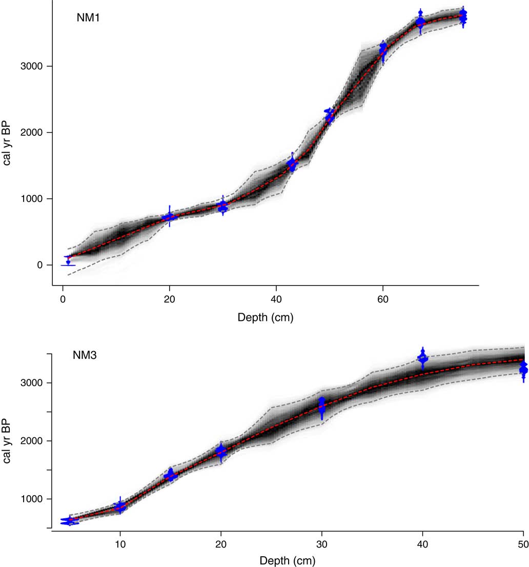
Cores NM1 and NM3 contained organic matter–bearing sands at the top of unit 1 and relatively thick, organic-rich unit 2 deposits (Figs. 6 and 7). These characteristics allowed us to 14C date nine horizons in NM1 and seven in NM3. Organic matter was less abundant in NM4, which allowed only four horizons to be dated (Supplementary Fig. 1). Core NM1 has the most comprehensive age model, with a postbomb (104.8 percent modern carbon [pMC]) age at the top of unit 2 and a median age of ~3760 cal yr BP at the deepest radiocarbon-datable horizon in unit 1 (~75 cm below lake floor [cm blf]). The upper 10 cm of NM1 appear to have been mixed, made evident by postbomb 14C ages at 1 cm and 10 cm blf; this may have been induced by the vibrocoring method. We excluded the postbomb age at 10 cm from the Bacon model and achieved a stationary distribution in the MCMC iterations and a good fit for the eight 14C ages with an accumulation rate prior modeled as a gamma distribution at a mean of 10 yr/mm (Fig. 8). The age of the unit 1–2 transition in NM1 was ~3200 cal yr BP; sedimentation rates varied from ~0.54 to 0.10 mm/yr, with mean of 0.30 mm/yr. The highest accumulation rates occurred from ~3740–3200 cal yr BP, just below the unit 1–2 transition. Sedimentation rates were low ~2710–910 cal yr BP but increase thereafter. Within the interval dated by 14C, the age-depth model shows variable temporal resolution, from several decades near the top of NM1 to several centuries moving deeper into the record. The only relatively deep unit 1 horizon in NH1 with age control is located at ~97 cm blf, which OSL estimates place at 7165±598 yr BP.
(color online) Bacon age-depth models for cores NM1 and NM3. See text for details.

Sediments from near the top of unit 2 in NM3 (~5 cm blf) returned a median age of ~650 cal yr BP, whereas sediments near the top of unit 1 had a median age of ~3400 cal yr BP. The age of the unit 1–2 transition in NM3 was ~3300 cal yr BP. The Bacon model for NM3 used an accumulation rate prior of 15 yr/mm to achieve a best-fit and stationary MCMC distribution (Fig. 8). No dates were excluded from NM3, though the 14C date at 40 cm blf is slightly older than the basal age at 50 cm blf. Sedimentation rates in NM3 varied from ~0.54 to 0.10 mm/yr, with a mean of ~0.21 mm/yr. The highest rates occurred from 3400 to 3150 cal yr BP, spanning the unit 1–2 contact. Sedimentation rates show a progressive decline from 3150 to 860 cal yr BP and a relative increase thereafter. The deepest dated horizon in NH3 was ~65 cm blf (unit 1), which OSL estimates place at 5797±507 yr BP.
Thin organic-rich deposits in NM4 yielded fewer 14C ages (n=4), with a large reversal between 20 and 13 cm blf (Table 1). However, NM4 yielded a postbomb date (106.0 pMC) at its top, and a median age of 4090 cal yr BP in muddy sands near the top of unit 1, several centimeters below the transition to unit 2. Because of the significant 14C reversal, it remains unclear if sediment accumulation was continuous across the unit 1–unit 2 contact (Supplementary Fig. 1).
Organic carbon (TOC) and carbonate (TIC)
All three lake sediment cores exhibited very low organic carbon content in unit 1. In unit 2, TOC averaged 5.0, 2.0, and 0.84 wt% in NM1, NM3, and NM4, respectively, with progressive trends to higher values in younger strata. A relative peak in TOC occurs at ~1510 cal yr BP in NM1, whereas a broad increase in TOC marks the NM3 record from ~3300 to 645 cal yr BP (Figs. 6 and 7). Carbonate concentrations increase abruptly near the unit 1–unit 2 contact in all cores. In unit 2, average TIC was 0.59, 0.93, and 0.52 wt% in cores NM1, NM3, and NM4, respectively. A peak in the % TIC chemostratigraphy lags the % TOC peak in NM1; the maximum carbonate concentration occurs at ~810 cal yr BP. At Salina Babaçu (core NM3), % TIC is relatively high throughout unit 2, but values decline after ~1800 cal yr BP.
TN and C/N
Average TN values in NM1, NM3, and NM4 were 0.35, 0.15, and 0.14 wt%. In general, TN chemostratigraphic patterns follow TOC in NM1 and NM3. Concentrations of TOC and TN are positively correlated in these cores (r=0.88, P<0.01 for NM1 and r=0.97, P<0.01 for NM3, respectively). Average C/N values were 16, 16, and 12 for NM1, NM3, and NM4, respectively, with a range of 11–21 in NM1 and NM3. A broad peak in C/N occurs at Salina da Ponta (NM1) from ~3200 to 1090 cal yr BP; C/N declines from ~910 cal yr BP to the present day (Fig. 6). In NM3, C/N is variable and lacks a well-defined trend (Fig. 7).
BiSi
Smear slides showed that sponge spicules were abundant near the base of unit 2 sediments, but they were also encountered in unit 1 for all cores. In these sediments, gemmoscleres and microscleres allowed for the identification of the genus Corvoheteromeyenia (Ezcurra Drago, 1979) in cores NM1 and NM3 (Fig. 9). Whereas spicules were absent near the tops of all our cores, diatoms were common at all stratal levels of unit 2, including the youngest sediments. These observations are consistent with measured trends in % BiSi (Figs. 6 and 7). Upper unit 1 sediments in all cores exhibit % BiSi values from 3% to 16%. Salina Babaçu (NM3) contained the highest average % BiSi in unit 2 (28%), whereas Salina da Ponta (NM1) and Salina Máscara (NM4) were less opal rich (averages of ~16% and 15% BiSi, respectively). A broad peak in BiSi occurs from ~3200 to 1510 cal yr BP in NM1, whereas peak BiSi in NM3 occurs ~2600 cal yr BP (Figs. 6 and 7). In both NM1 and NM3, % BiSi declines after reaching maximum values until ~710 and ~840 cal yr BP, respectively, after which time values stabilize and slightly rise toward the present day.
(color online) Corvoheteromeyenia spp. spicules from NM1. Siliceous remains of this sponge, which can tolerate fresh and mesohaline lentic waters, is common in the muddy units of all the cores studied from Nhecolândia. The disappearance of Corvoheteromeyenia microfossils suggests a change toward higher salinity and alkalinity in lake water. Scale bar is 25 µm. (A) Microscleres. (B) Megasclere fragments and gemmosclere. (C) Gemmosclere.

DISCUSSION
Fidelity of chronostratigraphic records from Nhecolândia’s saline lakes
A paucity of terrestrial plant macrofossils in these cores necessitated an approach to 14C geochronology that relied on dating fine-fraction bulk organic matter. Thus, the dates we report in Table 1 are conservatively considered maximum ages and provide multidecadal to centennial resolution for environmental reconstructions in those instances where stratal records are complete. The postbomb ages from the modern lake floors of Salina da Ponta (NM1) and Salina Máscara (NM4) suggest that the influence of reservoir effects and spuriously old sources of carbon may be minimal in the recent past. This is promising because the extant lakes likely experience longer residence times than more ancient ephemeral freshwater depositional environments in Nhecolândia. Other concerns related to the fidelity of these records are time averaging from bioturbation and sediment resuspension from physical processes, which may explain the 14C stratal disorder we observe in NM1, NM3, and most severely in NM4. To our knowledge, only one other study has examined sedimentation rates in lakes of the Taquari River megafan and that chronology was intact, which provides some independent evidence for continuous deposition in a different shallow saline lake from the region (Godoy et al., Reference Gierlowski-Kordesch, Finkelstein, Holland and Kallini2002). The bases of all cores were not dated in this study, and therefore, the maximum age of deposition, as well as the continuity of sedimentation in unit 1 time, remains unknown.
Cohen (Reference Cobos-Vasconcelos, García-Cruz, Franco-Morgado and González-Sánchez2003) described some of the temporal limitations associated with shallow lake sedimentary archives, which are typically short and moderate–low resolution because of a high potential for subaerial exposure. The records from Salinas da Ponta and Babaçu underscore some of these challenges but show promise for reconstructing regional hydrochemical changes over the last ~4000 cal yr from their sediments using 14C, with potential for extending the chronology using OSL dating. However, the results from Salina Máscara show that not all lakes from the region will be amenable for detailed paleoenvironmental analysis. The saline lakes of Nhecolândia are characterized by low-gradient margins and weak wave energy. Small lakes with these morphologies commonly accumulate massive carbon-rich muds that are precursors to desiccated and reworked palustrine facies (Alonso-Zarza and Wright, Reference Alonso-Zarza and Wright2010). Indeed, Nhecolândia serves as a possible analog for tropical palustrine facies development along distributary fan lobes. In the ancient geologic record, carbonate-rich lake deposits have been encountered along distal floodplains in megafan and alluvial environments, for example in the Tertiary of Europe (Freytet and Plaziat, Reference Fornace, Whitney, Galy, Hughen and Mayle1982; Sanz et al., Reference Silva and Abdon1995) and the Mesozoic of North America (Dunagan and Turner, Reference Deocampo2004). Gierlowski-Kordesch et al. (2013) attributed the development of carbonate lakes on siliciclastic floodplains to the dissolved load of large rivers draining hinterlands with abundant carbonate bedrock. Interestingly, the headwaters of the Taquari and Negro Rivers are incised in sedimentary and volcanic rocks of the Paraná basin, where carbonate outcrops are limited. However, very thin carbonate layers have been identified in the Permian Irati Formation, and therefore, some potential exists for dissolution of these rocks to influence river chemistry. More extensive carbonate outcrops exist in the headwaters of the Miranda and Aquidauana Rivers (Fig. 2), but these drainages are currently deflected to the south of Nhecolândia, and their influence on groundwater is likely minimal. Within the Pantanal, the spatial extent of recent carbonates in eastern Nhecolândia has not been extensively mapped. That region is nearly devoid of small lakes, but it could be another source of dissolved HCO3 2− to the lake-rich western Nhecolândia; more research is needed to verify this possibility. Nonetheless, our TIC data make clear that calcareous muds began to accumulate at these sites in the late Holocene, which we attribute to an important aquatic transition in the Nhecolândia.
Depositional environments
Our integrated facies and geochemical analysis provides new evidence for a marked change in depositional environment at Salinas da Ponta, Babaçu, and Máscara in the late Holocene (Figs. 6 and 7). Radiocarbon data from NM1 and NM3 indicate that the transition from unit 1 to unit 2 deposits occurred ~3300–3200 cal yr BP, whereas age data from the discontinuous NM4 place sediments near the top of unit 1 at ~4090 cal yr BP. We focus our discussion around core NM1 from Salina da Ponta, because it is our best dated and most complete record.
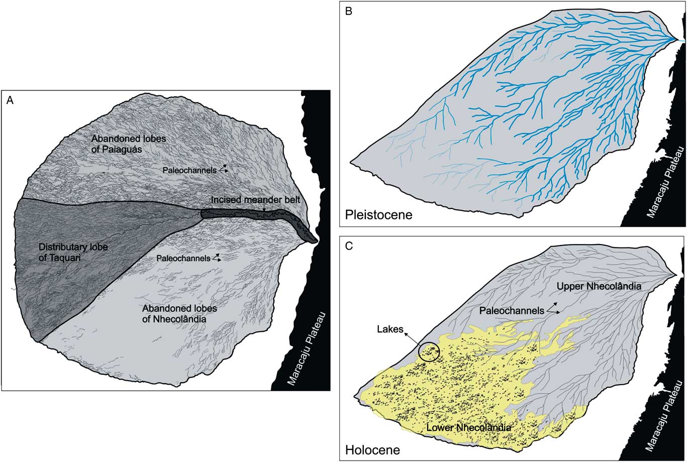
We interpret the well-sorted, massive fine to very fine sands with sponge spicules of unit 1 to reflect accumulation in ephemeral freshwater wetlands or shallow lakes. Zani et al. (Reference Wilhelmy2012) showed that Nhecolândia is an ancient distributary fan lobe of the Taquari River megafan. Unit 1 deposits are therefore interpreted as wind-reworked fluvial sands, which were periodically inundated by relatively freshwater (Fig. 10). The OSL and 14C data suggest that the upper portion of unit 1 was deposited in the middle Holocene, when the Pantanal experienced relatively dry conditions because of low insolation and a weak summer monsoon (McGlue et al., Reference Mariot, Dudal, Furian, Sakamoto, Vallès, Fort and Barbiero2012). We interpret that this period of aridity was responsible for deflating sand from the Nhecolândia fan lobe, which allowed depressions of variable depth with complex marginal sand ridges (cordilheiras) to form. The formation of these depressions allowed shallow lakes to evolve ~3300–3200 cal yr BP. This interpretation supports the findings of Assine and Soares (Reference Assine and Soares2004), who posited that the saline lakes in Nhecolândia were deflation pans. Interestingly, unit 1 particle sizes are similar to dune field sands in tropical South America, for example in the Llanos del Orinoco and the Gran Chaco (Tripaldi and Zárate, Reference Tricart2016). However, the absence of cross bedding and other eolian sedimentary structures suggests that unit 1 likely reflects a variably inundated, windswept fossil fan lobe rather than a true dune field. Sands in Nhecolândia were analyzed microscopically by Soares et al. (Reference Silva and Abdon2003), who found evidence for wind transport in particle sizes and the surface texture of quartz. However, those authors noted a complex mixture of fluvial and eolian quartz, with the possibility that pitted and abraded grains could be inherited from Mesozoic rocks in the surrounding watershed. By analogy, ephemeral freshwater lakes are common in the Lençóis Maranheses, one of the largest dune fields in Brazil (>1,500 km²) and a partial analog for unit 1. In the Lençóis Maranheses, seasonal rainfall elevates the water table, leading to temporary lakes amidst a complex field of dunes (Parteli et al., Reference Novello, Vuille, Cruz, Stríkis, de Paula, Edwards and Cheng2006; Luna et al., Reference Kuerten, Parolin, Assine and McGlue2012). Similar dunes were apparently not present in Nhecolândia, but the interdune environment of the Lençóis Maranheses shares a common trait. Where present, sponge spicules in unit 1 sands are dominated by the genus Corvoheteromeyenia (Fig. 9); this fauna has been described from the Lençóis Maranhenses, as well as other freshwater lakes in South America today (Volkmer-Ribeiro et al., Reference Victoria, Fernandes, Martinelli, de Cássia Piccolo, de Camargo and Trumbore1981; Volkmer-Ribeiro and Pauls, Reference Volkmer-Ribeiro, De Rosa-Barbosa and Mansur2000).
Paleogeographic sketch map of the evolution of lake-rich lower Nhecolândia. The region is approximately 250 km wide. (A) Extant geomorphological zonation of the Taquari River megafan, following Zani et al. (Reference Wilhelmy2012). The modern distributary fan emanates from an incised meander belt near the geographic center of the system. Abandoned fan lobes with abundant paleochannels are situated to the north (Paiaguás) and south (Nhecolândia). (B) Pleistocene development of the Nhecolândia as a distributary fluvial system. (C) The evolution of lake-rich lower Nhecolândia (yellow; Costa et al., Reference Cohen, McGlue, Ellis, Zani, Swarzenski, Assine and Silva2015) occurred in the late Holocene, following molding of the sandy substrate by wind during the arid early–middle Holocene. The study area is enclosed in a circle. (For interpretation of the references to color in this figure legend, the reader is referred to the web version of this article.)

An increase of clay, organic matter, and carbonate at the top of unit 1 suggests the transition to a more permanent lacustrine environment. Massive unit 2 muds are therefore lake deposits, which we interpret became progressively more saline and alkaline in the latest Holocene. Salinas da Ponta, Babaçu, and Máscara are characterized by low bathymetric gradients and minimal wave action, which favor the accumulation of autogenic sediments by suspension settling in the lake center, and a ring of nearshore sands and muds that are subject to desiccation when water levels recede. Within unit 2, the development of topographic closure is signaled by a reduction of sedimentation rates and sand content, and a concomitant increase in biochemical components as lakes became permanent on the fossil distributary fan lobe. We interpret the chemostratigraphic patterns of TOC and C/N to reflect aquatic productivity and the influence of runoff from ~3300 to 1510 cal yr BP, which suggests a relative increase in rainfall during the early deposition of unit 2. Bergier et al. (Reference Barbiero, Rezende Filho, Furquim, Furian, Sakamoto, Valles, Graham, Fort, Ferreira and Neto2014) noted that alkaliphilic cyanobacteria are an important component of carbon cycling in Nhecolândia’s saline lakes today, and Mariot et al. (Reference Malone, Santos and Sant’Anna2007) suggested that algae dominate the organic matter pool in these lentic ecosystems. These conclusions are partially supported by our C/N data. Lacustrine C3 algae typically have atomic C/N values of <10, whereas C/N for vascular plants are generally >20 (Meyers and Ishiwatari, Reference Metcalfe, Whitney, Fitzpatrick, Mayle, Loader, Street‐Perrott and Mann1993). In NM1, C/N values decline to <13 after ~560 cal yr BP but never attain a pure algal signal, which is consistent with our observations of terrestrial pollen from this interval. Based on the C/N data, we interpret that following initial transgression, seasonal overland flows washed minor amounts of allochthonous organic matter into the lakes, most likely derived from plants colonizing the adjacent cordilheiras.
The lack of covariation between TOC and TIC throughout unit 2 at Salina da Ponta suggests that carbonate precipitation was not solely the result of photosynthetic drawdown of CO2, although algal primary production appears to have become the most important control on % TIC chemostratigraphy after 1070 cal yr BP, if outliers are omitted. One plausible explanation for these outliers could be dissolution and recycling, which may affect carbonate accumulation patterns during intervals of intense rainfall. Nevertheless, lake morphology and late Holocene climate very likely influenced carbonate accumulation in these lakes, as the shallow bathymetry and high air temperatures combined to enhance evaporation and decrease calcite solubility (Talbot and Kelts, Reference Soares, Soares and Assine1990). In addition to evaporative concentration of lake water, photosynthesis by alkaliphilic cyanobacteria may have also influenced patterns of TOC and TIC, as this process transforms inorganic carbon into organic carbon (Cobos-Vasconcelos et al., Reference Clapperton2016). The presence of alkaliphilic cyanobacteria hinges on salinity and pH, and it appears likely that these blue-green algae took on greater importance for carbon cycling in Salina da Ponta as hydrochemistry and temperature changed in the latest Holocene, around the time that Corvoheteromeyenia spp. sponges were lost from the ecosystem. Another potentially relevant mediator of carbonate deposition in the saline lakes is sulfate-reducing bacteria. Bergier et al. (Reference Barbiero, Rezende Filho, Furquim, Furian, Sakamoto, Valles, Graham, Fort, Ferreira and Neto2014) noted that CH4 emissions from Nhecolândia’s saline lakes are low, in part because of oxidation of CH4 by sulfate-reducing bacteria, following Equation 1.
 $$CH_{\it4} {\plus}SO_{\it 4} ^{\,\,\,{\it 2{\minus}}} \to HCO_{\it 3} ^{{\it \minus}} {\plus}HS^{{\minus}} {\plus}H_{\it 2} O$$
This reaction produces HCO3 −, which is available to bond with diavalent metals in solution and precipitate authigenic carbonates from the water column. Methane emissions from the freshwater (macrophyte-dominant) lakes in Nhecolândia are high (Bergier et al., Reference Barbiero, Rezende Filho, Furquim, Furian, Sakamoto, Valles, Graham, Fort, Ferreira and Neto2014), and therefore, sulfate-reducing bacteria may be most efficient in the saline lakes.
Evaporative concentration of water has implications for sedimentation both within and along the margins of the saline lakes. Studies of soil mineralogy around saline lakes in Nhecolândia have documented the presence of chemical sediments including K-silicates, sepiolite, and saponite (Furquim et al., Reference Furquim, Barbiero, Graham, de Queiroz Neto, Ferreira and Furian2010a; Barbiero et al., 2016). Dolomite, gypsum, and Mg-silicates precipitate from concentrated brines following calcium carbonate, suggesting depletion in HCO3 2− in the saline lakes (Fig. 5). At Salina da Ponta, the % TIC curve in NM1 declines after reaching a peak at ~810 cal yr BP, which may indicate a partial drawdown of bicarbonate from the brine at that time (Fig. 6). However, all of the samples we measured via XRD contained at least trace amounts of dolomite, which suggests that bicarbonate was not fully exhausted from the evolving brines. Subsequent freshwater inflows, perhaps as the SASM strengthened in the latest Holocene, appear to have diluted the brine and allowed calcite precipitation to recommence after ~570 cal yr BP.
Barbiero et al. (Reference Barbiero, Rezende Filho, Furquim, Furian, Sakamoto, Valles, Graham, Fort, Ferreira and Neto2008) suggested that similar to Searles Lake (California) and trona pans in the Okavango Delta (Botswana), saline lakes in Nhecolândia may precipitate K-silicates from amorphous material, in association with sepiolite and saponite. In NM1 and NM3, we were unable to unequivocally detect the presence of octahedral Mg enrichment, neither by oriented XRD analyses of unit 2 clays nor on random powdered whole rock hkl reflections at high 2θ angles (Deocampo, Reference Debrot and Soest2015). However, this is may be owed to the heterogeneity inherent to Nhecolândia’s saline lakes, which vary in depth, surface area, and water volume. Furquim et al. (Reference Furquim, Graham, Barbiéro, Neto and Vidal-Torrado2010b) noted that high-pH, high-temperature brines can dissolve kaolinite, which is a source of Si that cements floodplain soils and provide a positive feedback on hydrologic restriction. Notably, only very minor amounts of kaolinite (0.0–4.4%) are present in sediments near the top of NM1 (Fig. 5). Increasing lake water pH in the late Holocene (after ~910 cal yr BP in NM1) likely caused the disappearance of Corvoheteromeyenia spp. (Fig. 6 and 9). The loss of these sponges cannot be attributed to depletion of aqueous silica; Almeida et al. (Reference Almeida, Paranhos Filho, Rocha, Souza, Sígolo and Bertolo2009) noted that saline lakes in Nhecolândia are saturated with respect to silica. Furthermore, BiSi concentrations remain elevated at the top of unit 2, and visual inspection of smear slides showed that diatoms are abundant in this interval. Many Brazilian sponges are highly sensitive to changes to alkalinity, but Corvoheteromeyenia are known to tolerate waters with a maximum pH of ~8.1, moderate electrical conductivity (2075 μS/m), and low salinity (Debrot and van Soest, Reference Debrot and Soest2001). However, the pH levels of many saline lakes in Nhecolândia exceed 9 and are restrictive to all but alkaliphilic aquatic life (Mourão et al., Reference Mortlock and Froelich1988; Santos et al., Reference Sakamoto2013; Bergier et al., Reference Barbiero, Rezende Filho, Furquim, Furian, Sakamoto, Valles, Graham, Fort, Ferreira and Neto2014). The extreme pH levels are therefore critical to biological interactions in the lake, as well chemical reactions in shallow soils adjacent to the lakes, which may provide a feedback on hydrologic closure by restricting subsurface outflows.
Holocene climate and the southern Pantanal
We interpret that Holocene depositional environment changes in Nhecolândia were likely driven by interactions among climate change, aquatic biogeochemistry, and morphological features on the fossil megafan lobe. Importantly, alkaliphilic cyanobacteria may influence sediment geochemistry and must be considered in addition to climate when interpreting saline lacustrine stratal records from Nhecolândia; these processes may vary temporally from lake to lake. In our records, unit 1 sands provide compelling evidence for reduced middle Holocene precipitation in the southern Pantanal, and the subsequent evolution of topographic closure in unit 2 (after ~3300 cal yr BP) suggests that deflation during the arid period played a role in generating accommodation on the southern fossil Taquari River megafan lobe. Paleoproductivity indicators (% BiSi, C/N, and TOC) from Salina da Ponta point toward a permanent lake sustained by greater rainfall in Nhecolândia from ~3200 to 1510 cal yr BP. As a consequence, our results are in accord with the proxy record of Bird et al. (Reference Bergier, Krusche and Guérin2011), which showed that after ~2200 cal yr BP, the SASM intensified and became more variable.
Where local controls do not obscure the stratigraphy (as observed in NH4 from Salina Máscara), our data provide support for linkages between monsoon strength and local water availability in the Pantanal. We argue that late Holocene changes in water balance were necessary background conditions for the evolution of saline-alkaline lakes in Nhecolândia. Baker and Fritz (Reference Baker and Fritz2015) explained that summer insolation and North Atlantic sea surface temperatures govern long-term precipitation variability in the South American tropics, and substantial proxy evidence now exists that supports a weakened monsoon in the early–mid Holocene (e.g., Thompson et al., Reference Thomas, Nash, Shaw and Van der Post1998; Hillyer et al., Reference Hamilton, Sippel and Melack2009; Kanner et al., Reference Junk, da Cunha, Wantzen, Petermann, Strüssmann, Marques and Adis2013). This same interval is marked by strong archaeological evidence of water stress on human settlements across wide areas of Brazil (Araujo et al., Reference Araujo, Neves, Piló and Atui2005). This pattern has been reported in southern Brazil, which shows that monsoon intensity is also linked with the position of the South Atlantic Convergence Zone through time (Cruz et al., Reference Cruz, Burns, Karmann, Sharp, Vuille, Cardoso, Ferrari, Dias and Viana2005, Reference Cruz, Burns, Karmann, Sharp, Vuille, Cardoso, Ferrari, Dias and Viana2009). The impact that reduced insolation had on the Pantanal lowlands is manifest in pollen, diatom, sediment chemistry, and biomarker records from Lagoa Gaíva sediments, which point to relatively dry conditions from ~10,000 to 3000 cal yr BP (Fig. 2) (Metcalfe et al., Reference McGlue, Silva, Zani, Corradini, Parolin, Abel and Cohen2014; Fornace et al., Reference Evans and Costa2016). Proxy records from Lagoa Gaíva are strongly influenced by the Upper Paraguay River flood pulse, which depends on the arrival of the SASM to initiate. The proxy reconstruction of flood pulse strength by McGlue et al. (Reference Mariot, Dudal, Furian, Sakamoto, Vallès, Fort and Barbiero2012) suggested that the inception of environmental conditions similar to modern occurred around the Little Ice Age. Models of SASM variability, as well as other proxy archives such as well-dated speleothems from western Brazil, also suggest higher precipitation in the region at this time (Novello et al., 2016; Rojas et al., Reference Rigonato, Kent, Alvarenga, Andreote, Beirigo, Vidal-Torrado and Fiore2016). Although counterintuitive, the evolution of salinity in Nhecolândia’s lakes reflects high latest Holocene effective precipitation as well. In spite of the region’s isolation from the flood pulse, maintaining water levels in Nhecolândia’s saline lakes requires strong rainfall to spur groundwater discharge to the deflation-molded depressions on the fossil fan lobe.
The coexistence of saline lakes and freshwater lakes in Nhecolândia has been attributed to variability in the height of a green Si-cemented sandy loam, which builds up in the shallow subsurface under alkaline conditions and serves as an impermeable barrier to water outflow (Barbiero et al., Reference Barbiero, Rezende Filho, Furquim, Furian, Sakamoto, Valles, Graham, Fort, Ferreira and Neto2008; Furian et al., Reference Freytet and Plaziat2013). The mineralogy of the loam is defined by neoformed Mg-smectites, Fe-illite, carbonate nodules, and amorphous silica (Furquim et al., Reference Furquim, Barbiero, Graham, de Queiroz Neto, Ferreira and Furian2010a). The timing of the development of this diagenetic layer may be latest Holocene, as highly alkaline conditions in the lakes are required to precipitate these minerals in adjacent soils; this hydrochemistry also favors the prevalence of cyanobacteria (Rigonato et al., Reference Rezende-Filho, Furian, Victoria, Mascré, Valles and Barbiero2013). The development of salinity is also owed to the presence of cordilheiras. These sandy vegetated ridges are commonly 2–3 m higher than the lake surface, and they act as partial barriers to erosive inflows during the rainy season and allow for evaporative concentration of brines once summer rainfall decreases (Barbiéro et al., Reference Barbiéro, de Queiroz Neto, Ciornei, Sakamoto, Capellari, Fernandes and Valles2002).
Implications for pans
The extant circular morphology coupled with the simple stratigraphy common to all of the saline lakes we have studied in Nhecolândia are consistent with pan processes described from other settings around the world. Pan development in the southern Pantanal was vital for biodiversity and the economic value of ecosystem services in the region, as the presence of standing water strongly influences rookery development, ranching activity, and agriculture (Seidl and Moraes, Reference Sanz, Zarza and Calvo2000; Pott and Pott, Reference Pott, Oliveira, Damasceno-Junior and Silva2004). Goudie and Wells (Reference Godoy, Padovani, Guimarães, Pereira, Vieira, Carvalho and Galdino1995) explained that the key control on pan formation is susceptible geomorphic surfaces, as the greatest numbers of these features form on unconsolidated sands that can be molded by wind or on weakly indurated rocks prone to weathering by salt crystallization and hydration. Abandonment of the southern distributary lobe of the Taquari megafan in the late Pleistocene (Zani et al., Reference Wilhelmy2012) provided an unconsolidated fine-grained sand substrate that was amendable to mobilization by wind during mid-Holocene aridity, which we interpret as an important step in the evolutionary history of topographic closure in Nhecolândia (Fig. 10). Pan-enclosed lakes that developed within fossil drainages have also been identified in Africa and Australia (Goudie and Wells, Reference Godoy, Padovani, Guimarães, Pereira, Vieira, Carvalho and Galdino1995), and the facies associated with these environments are commonly heavily burrowed, massive to horizontally stratified carbonates and evaporates (Ward, Reference Volkmer-Ribeiro and Pauls1988). Unit 2 muds from Salinas da Ponta, Babaçu, and Máscara share many of these traits. Massive lacustrine clays and carbonates have also been described from lunette-fringed playas on the southern High Plains (USA), and deflation is thought to be the primary mechanism in the formation of these features (Holliday et al., Reference Hogg, Hua, Blackwell, Niu, Buck, Guilderson and Heaton1996). Importantly, the nature of the underlying substrate and groundwater availability control several aspects of lacustrine deposition in pans. The potential bathymetry is determined by the thickness of the underlying substrate, which in the case of distal megafan deposits could be dekameters or more, though most subtropical South American megafan lakes formed by deflation are usually shallow (Cohen et al., Reference Cohen2015). Thomas et al. (Reference Talbot and Kelts1993) noted that the groundwater table controls the level of erosion in pans of the Kalahari Desert, and that the presence of water in the basin limits the potential of downwind lunettes forming from sediments deflated directly from the pan itself. The vegetated cordilheiras adjacent to the saline lakes studied herein consist of sand instead of desiccated lake muds, and thus the available evidence suggests that these features formed either prior to or during unit 1 time. The cordilheiras of Nhecolândia are complex landforms that do not share the leeside cuspate morphology of numerous pan-rich landscapes. The presence of the vegetated cordilheiras is interpreted to be critical for preventing erosion of saline lake deposits during annual floods, which, in addition to local biological and physical processes (reworking by bioturbation, resuspension), has implications for safeguarding the fidelity of their paleolimnological records.
CONCLUSIONS
Short sediment cores were analyzed to provide the first insights on the stratigraphy and sediment biogeochemistry of saline lakes in the Nhecolândia region of the southern Pantanal wetlands. Radiocarbon data indicate that two of three saline lakes were characterized by relatively intact stratigraphic records, which holds promise for inferring late Holocene hydroclimatic history; OSL ages extend the record into the middle Holocene, though the continuity of the records prior to ~3300 yr BP remains an open question. The dearth of paleoenvironmental records from the southern Pantanal makes this finding important, as datable geologic archives are vital for fully understanding the response of the wetlands to global change.
The saline lake sediment cores from Nhecolândia are typified by massive to very thinly bedded, tan fine-grained sands (unit 1) overlain by massive dark-green muds that contain abundant organic matter, carbonate, and BiSi (unit 2). Sponge spicules from the genus Corvoheteromeyenia suggest that ephemeral freshwater wetlands occurred during unit 1 time (middle Holocene). Unit 1 deposits reflect an abandoned fluvial megafan lobe that was reworked by wind during an arid interval in the Pantanal’s Holocene history. The evolution of topographic closure was marked by the deposition of unit 2 lacustrine facies. Sandhills (cordilheiras) surrounding the saline lakes today help to preserve their stratigraphic records by partially isolating the basins from erosive seasonal floods.
Slow sedimentation rates, high carbon content, and fine particle sizes in unit 2 revealed lacustrine depositional environments of varying hydrochemistry. Available 14C data indicate that these lakes became permanent ~3300–3200 cal yr BP. This timing is consistent with other proxy records from the Pantanal, which together suggest that the wetlands are sensitive to variability in monsoon precipitation. Our lake core data provide evidence for increasing salinity and alkalinity after ~910 cal yr BP. Development of saline and highly alkaline lakes in Nhecolândia requires strong seasonal water flow to available accommodation, restricted outflow, and evaporative enrichment. Maintaining hydrologic closure is partially a function of positive feedbacks associated with chemical cementation of floodplain soils as lake water alkalinity increases.
Equivalent doses, dose rates, and optically stimulated luminescence (OSL) ages for the studied samples from NM1 and NM3. Note that water content was estimated in laboratory, and an average value of 20±5% was applied to all samples. OD, overdispersion.

Acknowledgments
We acknowledge FAPESP for funding the “Research Program on Global Climate Change” (grant #2014/06889-2), the National Council of Technological and Scientific Development (CNPq) (447402/2014-5), and EMBRAPA for site access. MMM acknowledges the UK-VPR support grant program. RLG acknowledges CAPES for a doctoral scholarship. FNP acknowledges FAPESP for postdoctoral fellowship (grant #2014/23334-4). AS acknowledges grant support from CNPq (312386/2014-1). VO acknowledges an UK-EES Alumni Fellowship. MLA thanks CNPq for grant 308563/2013-1. M. Parolin, J. Lucas, J. Backus, and K. Schindler provided assistance with analyses. A. Sawakuchi facilitated the OSL dating. J. Talbot of K-T Geoservices completed the XRD analyses. L. Leuzinger provided the overflight photos. We thank our reviewers for their constructive comments on an earlier version of the manuscript.
Supplementary material
To view supplementary material for this article, please visit https:/doi.org/10.1017/qua.2017.57