

Introduction
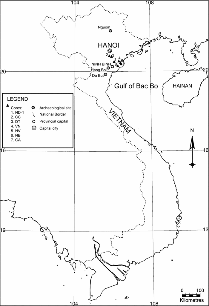
Tràng An is a Vietnamese government supported cultural and ecological park development covering 2,500 hectares that is centred on an isolated massif on the southern edge of the Song Hong delta in Ninh Bình Province, north Vietnam (Fig. 1). The archaeological investigation of Tràng An is being led jointly by the Xuan Truong Construction Corporation and the McDonald Institute for Archaeological Research, University of Cambridge, under the direction of the lead author. The Corporation is creating an ecologically sensitive development – the ‘Tràng An Tourism Resort’ – within this karstic landscape, which is also the subject of a planned application to UNESCO for World Heritage Site status. International involvement in this work has been at the behest of Nguyêń Van Truong, the General Director of Xuan Truong and at the invitation of the Ninh Bình People's Committee. The research itself is carried out under the guidance of Nguyêń Van Son, the Tràng An Tourism Resort Project Manager. The main focus of the May 2007 season was to undertake excavations at the site of Hang Boi (the ‘Fortune-Teller's Cave’).
The geographic location of Hang Boi and other key archaeological and sediment core locations mentioned in the text.

The subsistence and mobility strategies of Hoabinhian and other Late- to Post-Pleistocene cultural complexes in Southeast Asia have only rarely been the subjected to systematic investigation (Shoocongdej, Reference Shoocongdej1996b). Although detailed palaeontological studies are now being reported from Vietnamese cave contexts (e.g. Bacon et al., Reference Bacon, Demeter, Roussé, Long, Duringer, Antoine, Thuy, Mai, Huong, Dodo, Matsumura, Schuster and Anezaki2006; Long et al., Reference Long, DeVos and Ciochon1996), most archaeological reports from this region continue to focus on lithic analysis; faunal and botanical assemblages are identified to taxa, but rarely subjected to systematic study – though, see Mudar and Anderson (Reference Mudar and Anderson2007) and Shoocongdej (Reference Shoocongdej1996b) for exceptions. The Tràng An Project aims to contribute towards filling this analytical lacuna by using zooarchaeological, archaeobotanical and geoarchaeological research methods that have proven productive in other comparable Southeast Asian contexts (e.g. Barton, Reference Barton2005; Hunt et al., Reference Hunt, Gilbertson and Rushworth2007; Piper and Rabett, in review; Piper et al., Reference Piper, Rabett and Kurui2008; Rabett et al., Reference Rabett, Piper, Barker, Bacus, Glover and Piggott2006).
Tràng An is geographically very close to the known Early Holocene palaeo-coastline of northern Vietnam (see e.g. Tanabe et al., Reference Tanabe, Saito, Vu, Hanebuth, Kitamura and Ngo2006). In addition, the upland cave of Hang Boi contains cultural deposits that have been minimally disturbed by recent human activity – a source of considerable concern for archaeologists working elsewhere in the region. This location, therefore, provides an excellent opportunity for direct investigation into early human procurement and processing strategies, and should shed new light on human adaptation to the changing conditions across the Pleistocene-Holocene transition in northern Sundaland.
Palaeogeographic Context
The palaeogeographical evolution of this deltaic region that contains the Tràng An Park is now reasonably well understood through onshore and near-shore studies (Hanebuth et al., 2006; Hori et al., Reference Hori, Tanabe, Saito, Haruyama, Nguyen and Kitamura2005; Shimanski and Stattegger, Reference Schimanski and Stattegger2005; Tanabe et al., Reference Tanabe, Kazuaki, Saito, Shigeko, Vu and Kitamura2003, Reference Tanabe, Saito, Vu, Hanebuth, Kitamura and Ngo2006). Seven recently drilled onshore cores – designated ND-1, CC, DT, VN, HV, NB, and GA (Tanabe et al., Reference Tanabe, Saito, Vu, Hanebuth, Kitamura and Ngo2006) provide sedimentary sequences that cover the period from the LGM to the present (Fig. 1); with HV extending much further back to 40–45 kbp. All seven cores lie within a 50 km radius of the study area at Tràng An and collectively provide a detailed record of the Late- to Post-Pleistocene environmental changes within the delta.
Tanabe et al. (Reference Tanabe, Saito, Vu, Hanebuth, Kitamura and Ngo2006) ascribe the sedimentary facies within these cores to three units. Unit 1 has two dates, 12,6500 ± 110 uncal. yr BP (Beta-142418) (14,950 ± 580 cal. BP) and 12,470 ± 110 uncal. yr BP (Beta-142417) (14,840 ± 580 cal. BP), and contains fluvial sediments characteristic of those generated in a meandering river system. Sediments ascribed to Unit 2 date from 9,970 ± 90 uncal. yr BP (Beta-142414) (11,430 ± 200 cal. BP) to 8,220 ± 50 uncal. yr BP (Beta-164867) (9,210 ± 180 cal. BP) and were deposited under conditions influenced by tidal action. The presence of wood and plant fragments as well as molluscan shells of Potamocorbula sp. and Corbicula sp. is taken by Tanabe et al. (Reference Tanabe, Saito, Vu, Hanebuth, Kitamura and Ngo2006: 39) to suggest brackish water, indicative of an estuarine environment. The core closest to Tràng An, ND-1 (c.30 km) contains indicators of tidal flats with salt marsh elements for Unit 1. Over the course of this aggradation, regional models suggest the sea level would have risen from -50 m to -15 m below its modern value, bringing the palaeo-coastline from c.60 km to <20 km away (after Voris, Reference Voris2000). Although tectonic movement since the Last Glacial Maximum (LGM) (c.21–17 kbp) is reported to be between two and three orders of magnitude lower within the Sundaland region than it is at its edge, where active zones can experience rates of movement up to 10 mm/year (Tjia, Reference Tjia1996), the maps constructed by Voris (Reference Voris2000) remain, by that author's own estimate, approximations that will be subject to future refinements for tectonic movement. The distances presented here, therefore, must also be taken as provisional.
Unit 3 dates from as early as 8,970 ± 40 uncal. yr BP (Beta-164823) (10,090 ± 100 cal. BP) to the modern period and contains deltaic sediments. By this time, the previously marine-inundated Song Hong valley had began to infill with fluvial sediments, allowing the development of mangrove forests on inter-tidal mudflats across the tidal plains during the next millennium, including the area between the palaeo-coastline near the modern-day town of Ninh Bình and the eastern side of Tràng An. Ninh Bình itself would have been submerged c.7–6 cal. kbp and then covered by mangrove forest once again 6–4 cal. kbp (Tanabe et al., Reference Tanabe, Kazuaki, Saito, Shigeko, Vu and Kitamura2003, Reference Tanabe, Saito, Vu, Hanebuth, Kitamura and Ngo2006).
Our field reconnaissance work in the vicinity of Hang Boi suggests the following geomorphological points are relevant to understanding the cave and its human context. The local solid geology of the Tràng An area is mostly of limestone of Triassic age on the evidence of rare fragmentary Ceraititid amonoids and recycled palynomorphs in the Quaternary deposits. This limestone is reported by a local informant at the Ninh Bình Museum to be several thousand metres thick and comprises massively-bedded shallow marine lagoonal and reef limestones with occasional intraformational palaeosoils and palaeokarst features. These Vietnamese coastal ranges are mostly strongly folded sedimentary rocks, sometimes with vertical beds, but in the core of the research area, bedrock dips are low. Low-grade mineralisation is common, with veins in-filled with calcite and haematite. Small pressure-solution calcite veins and styolites are also frequent. The thermal maturity of the rocks and the evidence for mineralisation and pressure-solution suggest burial in the past to depths of several km. Unroofing most probably began with uplift during the Mesozoic.
The limestone is highly-dissected by both dissolution processes and collapse into a series of high (up to c.200 m) and precipitous karst towers separated by dolines (areas of solution and collapse, which are often the result of palaeo-cave collapse. A broad concordance of summit heights suggests that an original plateau-like landform was once present and has been dissected subsequently. The karst towers often contain caves and other smaller solutional cavities and often show highly-developed karren (gutterlike solution features) on their surfaces. Our unpublished field research suggests that the hydrology of the region may be controlled to a considerable extent by the well-developed cave and fissure systems evident in the limestone, so that a regional water-table is in the process of developing. This regional water-table appears to be controlled by base-level, essentially responding to sea-level as this area is on the edge of Vietnam's coastal plain. Sedimentary fills have accumulated in the dolines. The soils that developed on the sedimentary fills are often highly acidic in character and thus cause strong dissolution and the formation of solutional notches at the base of the karst towers. The development of deep (2–4 m) solutional notches is observed to have led to undercutting of the margins of the karst towers and thus large-scale rock-failures from their flanks. Incipient failure planes and landforms diagnostic of recent large-scale slope failure are visible in a number of localities and it is evident that the cliff-like sides of the karst towers are maintained by undercutting and collapse of the limestone. A major cliff collapse of this type would involve the fall of many thousands of tons of rock, and that such an event would produce a localised shock equivalent to a magnitude 3 to 5 earthquake. Such an event might trigger other rock-falls and cave-collapses in the area.
The caves of the area show a range of features consistent with formation under a variety of contexts. Collectively these provide additional evidence for the development of the area.
1. Phreatic caves have a characteristic circular cross-section and a path that meanders both horizontally and vertically, caused by the enlargement of initial porosity by helical flow below the water-table. Other smaller-scale features such as flutes (regular wave-form sculptural elements on cave walls) and phreatic domes (cupola-like features caused by eddies) are also characteristic. Circular cross-sections are visible in cave entrances and cross-profiles up to c. 150 m above the current regional water-level. Flutes and phreatic domes have only been seen in caves on the regional water-table and in Hang Boi, where they are well developed.
2. Vadose caves owe their morphology to processes occurring at or above the water-table and thus have a wide range of morphology. Most caves so far seen on the project show pronounced vadose morphology, including shafts, vadose canyons (caves with a pronounced canyon-like morphology caused by the down-cutting of a submarine stream) and various karren-like features most likely produced by water running down or falling on inclined surfaces. The sedimentary fills seen so far in the project also are consistent with development under vadose conditions and include rockfall deposits, fine-grained muds, middens and flowstone (stalagmitic material). Caves with vadose morphology can be seen high on the walls of the karst towers: Hang Boi itself shows a well developed shaft over 20 m high and the entrance is now c.78 m above the regional water table.
Field observation supports the interpretation that the area has evolved through millennia of weathering and erosion during the later Tertiary and Quaternary. Caves and other karst features will have started to form as soon as the limestone was unroofed by erosion. Many of the dolines in Tràng An are probably the remnants of ancient collapsed caves. As the cave systems evolved, so also would have developed a regional water-table, which will also have been controlled by a base-level that will have fallen relatively as uplift proceeded. Base-level history will; however, have been complex. During periods of low sea during Pleistocene stadials, the base level will have been up to c.120 m below modern sea-level (Voris, Reference Voris2000) and there will have been down-cutting of major valleys in the region and to some extent in the outer reaches of the research area. It is not presently evident how far this trenching will have affected the hydrology or the doline fills within the research area but, in principle, it might be expected that at least some cave systems extend well below the current water table. The effects of long term (greater than 100,000 years ago) regional uplift (e.g. Voris, Reference Voris2000) may have ensured that cave systems, which developed below or at the regional water table, will have been lifted above it. It follows that the most ancient caves are likely to be topographically the highest above sea level, but assigning ages and determining rates of uplift will have to await further field research.
Archaeological Context
The wide floodplain of the Song Hong delta and precipitous limestone uplands have been a long-standing focus of archaeological investigation and have produced five major ‘archaeological cultures’ the Ngoumian, Sonvian, Hoabinhian, Bacsonian and Dabutian. Although radiocarbon dating has made it possible to place some degree of organisation onto the chronological relationship between these complexes, different lithic forms sometimes do still appear to have existed concurrently (Nguyen Gia Doi, Reference Doi2005). This raises questions about the strength of the chronological and typological divisions of these complexes and complete consensus has yet to be reached about their relative antiquity (Reynolds, Reference Reynolds and Barnes1990). The Nguòm rock shelter, located on the north face of a limestone mountain in Bac Thai province (Fig. 1), is a useful point of reference because it contains evidence attributed to three of these archaeological cultures.
The lithic industry from the lowest level at Nguòm is assumed to date to before 23 kbp (the age ascribed to the overlying cave sediment unit) and is termed the ‘Nguòmian’. It is distinguished from later industries on account of a high frequency of small flake tools, points, scrapers and knives - as well as possible blades and blade tools and a small pebble-tool component (Reynolds, Reference Reynolds1993). This predominance of flake-tools is taken to refute the long-held notion that a core-tool based technology extended in unbroken line deep into the Pleistocene (Ha Van Tan, Reference Tan1999). Details of the faunal component are scant, but identified taxa include a mixture of terrestrial and arboreal taxa, including Sus scrofa, Cervus unicolor, Macaca sp. and Pongo pygmaeus; no molluscs were recovered here or from similarly dated sites. The suite of animal remains from this period is seen as part of the Pongo-Stegodon-Ailuropoda ‘zoological community’ identified in southern Chinese province of Yunnan from c. 50–30 kbp (Hoáng Xuân Chinh, Reference Chinh1991).
The lithic component from the middle sedimentary unit of the cave-infill is typologically assigned to the ‘Sonvian’ and contains, in addition to elements from the lowest cultural layer, a much larger number of pebble tools – some of which bear a resemblance to later Hoabinhian lithics, though there has been debate over the likely extent of that affiliation (Reynolds, Reference Reynolds1993; Ha Van Tan, Reference Tan1997). There are apparent changes in the character of the cave-sediments following the deposition of the basal component of the Nguòm assemblage and these lithological changes have been taken as evidence that the middle cave-infill unit, dated near its base by two uncalibrated radiocarbon dates – 23,000 ± 200BP (Bln-2692/I) and 23,100 ± 300BP (Bln-2692/II) – may have been deposited under different climatic conditions to those of its predecessor (Hoáng Xuân Chinh, Reference Chinh1991). Land snails (Cyclophorus dodrans and Cyclophorous speciosus) begin to appear in this unit, but quantified numbers are not reported and there is a ‘considerable’ (but unspecified) drop in frequency of two of the previous marker species: Ailuropoda and Pongo pygmaeus (though isolated teeth of the latter do occur). There is also a continued presence of other previous vertebrate taxa, such as Cervus unicolor and Macaca sp., though no details are available about whether continuity in identified species masks change in population structure, as has been found to be the case elsewhere in the region (e.g. Piper et al., Reference Piper, Rabett and Kurui2008). The vast majority of the approximately 140 Sonvian sites thus far discovered in northern Vietnam are open-sites lying along elevated river terrace surfaces above the Bac Bo plain (Ha Van Tan, Reference Tan1997). Although such sites provide an important adjunct to a regional prehistoric vista, which is otherwise dominated by cave sites, there is very limited survival of other organic materials to permit systematic study of subsistence practices. Therefore, there is no way to determine if the spectrum of taxa represented at Nguòm is typical or atypical of this complex.
The faunal remains from the upper cave sediment unit at Nguòm indicate the continued importance of cyclophorid molluscs (Cyclophorus dodrans, C.siamensis, C.fulganatus and C.specious); however, there is also an increase in the abundance of freshwater molluscs, e.g. Brotia (=Antimelania) siamensis, Brotia (=Antimelania) costula and Angulyagra sp. By this time, Ailuropoda and Pongo pygmaeus no longer occur; and all identified vertebrate remains are from extant species, and may have more terrestrial associations, with Babalus bubalis, Sus scrofa and Cervus unicolor all described (Hoáng Xuân Chinh, Reference Chinh1991). A radiocarbon date taken from the base of the upper sedimentary unit places the final deposits at Nguòm close to the end of the LGM, 18,600 ± 200BP (Bln-2691/2) uncalibrated. Notable elements of the lithic assemblage are unifacial core tools and edge-ground tools, consistent with a late Hoabinhian or Bacsonian tradition, though chronologically this is an early manifestation of either, but especially for the latter complex, which, in addition to the Hoabinhian suite of tool forms, also tends to contain protoneoliths and some ceramics. Regionally, the age-range of the Hoabinhian is yet to be firmly established (Shoocongdej, Reference Shoocongdej1996b). A key component from Vietnamese sites attributed to the Hoabinhian is the ‘sumatralith’ – a unifacially-flaked pebble tool (Ha Van Tan, Reference Tan1997). Elsewhere in the region, sites with Late Pleistocene dates ascribed to the Hoabinhian tend to exhibit a mixture of uni- and bi-facial pebble tools (e.g. Zuraina Majid, Reference Majid1994, Reference Majid1998). Most of these assemblages though, such as Spirit Cave in northern Thailand (Gorman, Reference Gorman1970), date from the end of the Pleistocene or Early Holocene.
After 8 kbp (uncal.), Hoabinhian sites in Vietnam and elsewhere begin to carry a ground stone and ceramic component in addition to their flaked pebble tool component. This has been linked to a shift in economic activity, though links to domestication have not been demonstrated (e.g. Hoáng Xuân Chinh, Reference Chinh and Bayard1984). In terms of the time-span of this industry in Vietnam, early Hoabinhian technology is reported from the site of Tham Khoung, dating to 33,150 ± 2300BP (Bln-1412) uncal. However, most sites in Vietnam are largely confined to the uplands south of the Song Hong and fall between c. 18 and 7 kbp (uncal.), a longer span of time than is seen elsewhere. Geographically, it is also separated from the Bacsonian, which appears in the region to the north of the Song Hong from c. 10 kbp (uncal.) and ends at around the same time, c. 7 kbp (uncal.) (Reynolds, Reference Reynolds and Barnes1990).
With the exception of one open-air (Mid-Holocene) site, Bau Du (Ha Van Tan, Reference Tan1997), the Vietnamese Hoabinhian does not appear to have included adaptation to coastal settlement or exploitation. Although the chances of discovering Late Pleistocene coastal sites in Southeast Asia is very remote because of subsequent marine inundation, the Mid-Holocene sea-level high-stand c.6–4 kbp (uncal.) (e.g. Tjia, Reference Tjia1996; Verstappen, Reference Verstappen1997) provides an important window into the distribution, intensity and character of coastal occupation by hunting and gathering communities. This has been particularly well demonstrated, for example by the excavations at Khok Phanom Di in south central Thailand.
The thick cultural deposits at Khok Phanom Di accumulated on top of marine clays, probably laid down 7–4 kbp (uncal.) during a series of coastal inundation events (Higham and Maloney Reference Higham, Maloney, Harris and Hillman1989). Over the five or six centuries of its occupation, starting c.3,560 ± 60BP (anu-5493) (uncal.), the site's environs changed significantly. Holocene sea-level recession transformed local mangrove swamp and estuarine habitats that had dominated the earliest phase to dry evergreen forest and swampy open woodland (Higham and Thosarat, Reference Higham and Thosarat1998, Reference Higham and Thosarat2004). These changes did not deter people though. A predominance of aquatic food sources continued through-out, and especially prior to c.3.2 kbp, while mammal fauna became more important as immediate access to marine and riverine resources was lost (Kijngam, Reference Kijngam, Higham and Bannanurag1991). Rice appears as an inclusion in potting clay from the site's basal levels and as more abundant chaff later on in the sequence, and was clearly an important part of the diet of these people obtained through independent harvesting or emerging exchange mechanisms; rice cultivation here is possible though evidence remains inconclusive. The character of the adaptive strategies employed at Khok Phanom Di suggests inhabitants were the descendants of established coastal hunter-gatherers rather than of recent arrivals from the interior (Higham and Thosarat, Reference Higham and Thosarat2004).
A similar settlement pattern appears to have existed along the coastal lowlands of the Gulf of Bac Bo, where evidence of settlement has come to light on raised beaches dated to the same period. One of the most well known is the site of Da But (type-site of the ‘Dabutian’) – first excavated in 1926–7 and most recently in 2002 (Fig. 1) (Nguyen Viet, Reference Viet2005). This site is regarded as providing some of the clearest evidence for human adaptation to the Mid-Holocene high sea stand (Nguyen Viet, Reference Viet2005). Current interpretation suggests a complex economy was practiced by the people using this open-air midden site, drawing resources from a number of different environmental niches in adjacent uplands, freshwater swamp, lake and riverine habitats, and extending out into the sea (Nguyen Viet, Reference Viet2005). Occupation at Da But lasted from c.6.5 – 5.5 kbp (uncal.), and had an economic base that included significant quantities of Corbicula sp. in its earliest layers. A greater frequency of marine molluscs appear through the course of the high-stand, and are interpreted as indicating a change in subsistence practice (Nguyen Viet, Reference Viet2005), before a return to the exploitation of freshwater resources as the sea level stabilised.
This brief summary of the archaeological cultures from the Late to Post-Pleistocene of northern Vietnam indicates the wealth of evidence available from this region. Research undertaken to date hints at a range of shifts in economy that were made by early human groups in response to the environmental changes affecting the Song Hong deltaic region from the Late Pleistocene onwards. More targeted study of these shifts in subsistence strategy will help determine the course and complexities of this adaptive process. The aim of the Tràng An Project is to contribute towards this undertaking.
Hang Boi: The Upper Cave
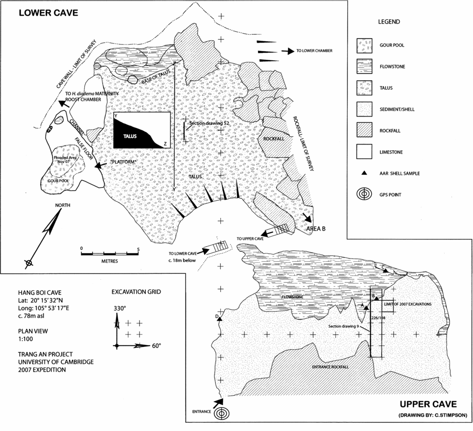
Hang Boi is a spacious cave (19.7 × 10 m) with a large interior cavern 18.23 m beneath the cave mouth (Fig. 2). Recently rediscovered (Tâń, Reference Tâń2002) the cave is located c. 78 m asl at Lat. 20° 15' 32”N; Long. 105° 53' 17”E (UTM 48Q 592 746 224 0377), 35.6 km from the present-day coastline. The cave has a SSE aspect that overlooks a small cultivated doline at 2.8 m asl.
Plan of the Upper and Lower cave at Hang Boi, including the locations of key sections and locations of cyclophorid samples taken for AAR dating.

During the May, 2007 field season geomorphological assessment was concentrated on mapping the erosional and depositional features of the cave. This provides the first step towards deducing the history and palaeoenvironments of the site. Our field reconnaissance indicates that Hang Boi has a complex morphology: originally phreatic, but overlaid by strong features of vadose origin, and shows a long history of development. Details of this development are as yet unclear, but many should be resolved by a dating programme. Relics of phreatic morphology in the ‘Upper Cave’ (the cave mouth) include well-developed flutes with a wavelength of c.1.2 m and a series of small, poorly-developed phreatic domes. The orientation of the flutes suggests a water current moving from the present valley into the cave, and their size is consistent with considerable velocities. These features demonstrate that the entrance area was once part of a large phreatic system that must have extended through the valley in front of the cave. Most of this former system has been lost through erosion, doline collapse and cliff/slope recession. The current relatively flat floor of the entrance area is the result of depositional build-up behind a boulder rampart, itself caused by collapse of the cliff outside the cave. There is evidence from remnant flowstone deposits for the collapse of a former rampart and partial collapse and loss of an earlier fill of this area. The roof of the entrance area has recently evolved by stoping (collapse of slabs from the cave roof). Much of the current entrance floor area is composed of shell midden deposits, interdigitating with and partly overlaid by flowstone deposits. These deposits are generally particle-supported, sometimes almost openwork in texture, with layers of crushed shells infrequent. This suggests that there was little foot-traffic upon the midden.
The flowstone, in places, forms substantial rounded stalagmite forms under areas where there are significant concentrations of stalactites on the cave roof. These are currently inactive: pitting in the surface of these stalagmites shows that current drip-water is acid, whereas the formation of flowstone requires calcareous, alkaline waters. Generally, most flowstone in the cave is inactive or barely active at present and even in times of heavy rain there is remarkably little drip water in the cave. This observation suggests two hypotheses: either that drainage waters have been comprehensively re-routed since deposition of the flowstone or, and more likely, the flowstone reflects periods of extremely high rainfall. Though as yet not directly dated, given the radiocarbon dates obtained from the underlying midden, the flowstone appears to have been deposited during the earlier part of the Holocene.
The flowstone cap has been breached in some places and irregular ‘robber-pits’ – from digging or the removal of root boles – have scooped out the underlying midden in two adjacent areas. Further minor damage to the deposits has been done by erosion caused by footwear in the recent past. The Early Holocene flowstone deposits associated with the main shell-midden deposits are characteristically micritic (very fine-grained) in texture and thus distinguishable from older recrystallised flowstone. Older shell-midden deposits, sometimes ashy and sometimes containing animal bones, are present around the edges of the entrance area. These older deposits are overlain by and inter-digitate with flowstones, which are crystalline in texture, with crystal size generally increasing with relative geomorphological ‘age’. The older midden and flowstone deposits are clearly erosionally truncated, suggesting that there was at least one or more episodes of collapse of the former cave fill deposits, most probably as a result of collapses of former entrance ramparts.
Preliminary Amino Acid Racemization (AAR) analysis was undertaken by Dr Kirsty Penkman at the University of York on 8 individual Cyclophorus sp. (now, identified as Cyclophorus unicus and C.theodori) shells, collected by one of us (GB) during a reconnaissance visit to Hang Boi in 2006 from 4 horizons (Table 1; Fig. 2):
Samples of Cyclophorus unicus and C.theodori obtained from Hang Boi and submitted for AAR

This pilot AAR study established that the concentration of amino acids within the bleached intra-crystalline fraction is sufficient for future analysis. As no previous work has been carried out on this species, and given that the decomposition patterns appear to be different to other species (greater racemisation in the hydrolysed fraction for given free amino acid D/L values, high levels of free amino acids), along with the unknown natural variability of the samples, definitive age attributions could not be made. However, relative age estimates were obtained indicating that the samples probably came from a range of different periods, with one sample significantly older than the others (Penkman, pers. comm.).
Upon returning in 2007, a grid was established a site grid in the Upper Cave. This was orientated utilising a calibrated Suunto MC-2 G mirror-sighting compass as follows: Site North: 330° NNW; Site East: 60° ENE. Excavation began with the removal of a loose re-deposited shell scatter lying to the (site) west of two shallow surface depressions. The origin of the latter is unclear though they may be the result of abortive treasure-hunting. A single, L-shaped 1 m wide trench (Trench 1) aligned (site) North-South was laid out from just beyond the drip-line at the front of the cave to within 4 m of the back wall – a total of 9 m. Initial excavation at the southern end of the trench quickly revealed a small sub-surface area of ashy, dark-grey sediment context (5003) (Munsell colour: 10YR 4/1 dry, 10YR 2/2 wet). Almost certainly representing the remains of a small fire, these deposits were interpreted as in likelihood the residue of a votive offering. The presence of similar, modern votive spots elsewhere in the cave makes this a credible supposition. The sediment below these layers was very disturbed by root action, clearly subject to persistent vegetation growth – that covers the entire span of the cave entrance. No further work was carried out in this location for these reasons.
Excavation was concentrated in four square metres of Trench 1 immediately to the north of this location (Fig. 2) – in grid squares 226/107–8, 226/109 and 227/109. A thin layer of red-brown sediment (10YR 4/3), context (5006), was removed in the former of these squares down to an ashy-textured brown deposit (10YR 4/3 dry and wet, context (5005). Part of this deposit on the eastern side of the 226/ trench line included a lithofacies of cemented shell with a small flowstone boss. This is likely associated with run-off from a small stalagmite just outside the trench at this location. Such localised secondary changes within the midden appear to be affecting deposits, which otherwise exhibit comparatively little lithological variation. In light of this and to ensure fine-grained recovery, the four grid-squares were excavated in 0.5 × 1 × 0.1 m context/spits with one in every four buckets being dry sieved through 2 mm mesh. This procedure was followed through the rest of the season's excavation, excepting a single deep sounding dug straight down in square 227/109 to access the depth of the midden, and during which every fifth bucket was dry-sieved.
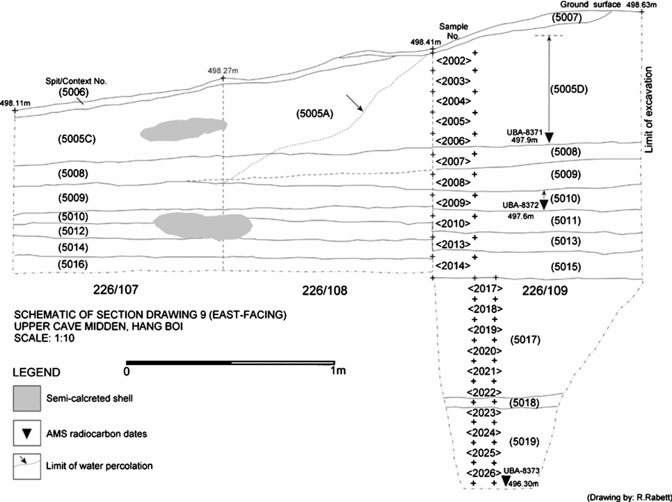
Work was halted in the deep-sounding at c. 2 m below ground level (Fig. 6), at which point shoring would have been necessary to continue. By this depth we had not yet come to the base of the midden or observed any appreciable changes in its character, leading us to conclude tentatively that this may constitute essentially a continuous phase of deposition. This contention is supported by three ranging dates from these deposits, though the periodicity of occupation (be it continual or episodic, or affected by spells of hiatus) will only be determined with a series of more closely-spaced dates through the sequence.
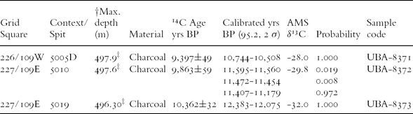
The new dates were obtained on charcoal samples (Table 2) taken out of the numerous small charred fragments (that also included seeds and parenchyma): such remains were recovered from almost every excavated context. Charred remains of seeds, and wood were recovered at the sieves and during flotation, and will provide important additional axes for subsistence and environmental reconstruction. Two radiocarbon samples were taken from near the top of the sequence from contexts (5005) 10YR 4/3 dry and (5010) 10YR 4/3 dry, 10YR 3/2 wet, in grid squares 226/109 W and 227/109E respectively. The vertical distance between can only be calculated between the maximum depth of each of these spit/contexts (0.3 m). The final sample came from the base of the deep-sounding in grid square 227/109E context (5019) dark grey brown, 10YR 4/2 dry and damp, 1.3 m below (5010) (Fig. 3). All three samples were processed by the 14CHRONO Centre, Queen's University, Belfast and returned sequential AMS dates (from top to bottom) of 9,397 ± 49BP (UBA-8371) (10,744 – 10,508 cal. BP), 9,863 ± 59 (UBA-8372) (11,407–11,179 cal. BP) and 10,362 ± 32BP (UBA-8373) (12,383–12,075 cal. BP) (Table 2). These dates indicate that the upper 2m of the midden may have accumulated over a period of approximately two thousand years (though periods of hiatus between sampled levels could potentially reduce this timescale) in late Unit 1 or early Unit 2 periods of the evolution of the Song Hong delta (Tanabe et al., Reference Tanabe, Saito, Vu, Hanebuth, Kitamura and Ngo2006). The coastline at this time was up to 60 km away and the local Song Hong was either a meandering freshwater river or else was beginning to develop estuarine characteristics. Significant occupation associated with the Upper Cave midden appears to have come to an end at the very on-set of the Holocene (though more fine-grained dating of this part of the sequence will be needed to clarify the timing). The deposits were then sealed under a flowstone cap after an undisclosed time, though likely still during the early part of the Holocene.
14C dates obtained from spit/contexts within the Upper Cave midden, Hang Boi. †depth measurements are relative to a 500mTBM. ‡UBA-8371 is only a very broad range-finding date as it is the least accurately placed within the 5005D context; additional dating in this part of the sequence will be crucial to determine accurately when accumulation ended and the midden was capped. UBA-8372 is accurate to within 10 cm of deposit. The exact depth of sample UBA-8373 was independently determined on site using a dumpy level and staff. Dates were calibrated using CALIB REV. 5.0.2 in conjunction with Reimer et al. (Reference Reimer, Baillie, Bard, Bayliss, Beck, Bertrand, Blackwell, Buck, Burr, Cutler, Damon, Edwards, Fairbanks, Friedrich, Guilderson, Hughen, Kromer, McCormac, Manning, Bronk, Reimer, Remmele, Southon, Stuiver, Talamo, Taylor, Plicht and Weyhenmeyer2004) and Stuiver and Reimer (Reference Stuiver and Reimer1993).

Schematic drawing of the east-facing Section: 9 showing the spit/contexts excavated, the locations of environmental samples (sediment and molluscan analysis), and the locations of charcoal sampled for radiocarbon dating. For the purposes of this diagram, the east-facing section of the deep sounding in square 227/109 is included, though there is a break of section between the base of sample <2014> and the top of <2017>.

Isolated pockets of cemented land snail deposits around the periphery of the walls in the Upper Cave are overlain by geologically older flowstone caps. Indeed, our current understanding is that there are several phases of flowstone accumulation represented in the upper cave, suggesting deposition and possibly human activities at this site dating well into the Upper Pleistocene – a conclusion consistent with the preliminary AAR results.
Land snails within archaeological deposits often occupy a somewhat ambiguous space, frequently being regarded as ‘self-introductions’ rather than as part of cultural subsistence practices (e.g. see Medway, Reference Medway1960). Although a well-reported feature of Hoabinhian deposits in this part of Vietnam (e.g. Hoáng Xuân Chinh, Reference Chinh1991), the status of land snails as a deliberately collected and consumed resource by humans has been rarely explored in detail. Methods for accurately distinguishing between culturally- and naturally-introduced terrestrial snails are under-developed currently, though effort is being made to address this issue (e.g. Lubell, Reference Lubell, Brugal and Desse2004a, Reference Lubell and Budja2004b; Szabó et al., Reference Szabó, Ramirez, Anderson and Bellwood2003). The case of Hang Boi is relatively straight-forward, with the land snail accumulations clearly being human-derived. This interpretation is advanced on the basis of various aspects, such as species representation – both in the cave deposits and the surrounding environs, as well as aspects of taphonomy and spatial arrangement: (i) the shape and nature of the cave, as well as the thick covering of land snails across the cave, indicate that the shells were not blown, washed or dropped into the cave; (ii) many of the shells are whole and undamaged suggesting that snail predators, such as birds or rodents, are not significant vectors of accumulation here; (iii) biogeographical ranges of modern snail taxa represented around the cave indicate that local land snail diversity is rich, with a number of families commonly present, including the Cyclophoridae (a range of genera including Leptopoma, Scabrina, Japonia, Pterocyclos and Cyclophorus), Camaenidae, Clausiliidae, Pupinidae, Zonitidae (Trochomorphinae), Subulinidae and Streptaxidae. This diversity, coupled with the relative natural abundances of individuals within these families, contrasts starkly with the composition of the deposits at Hang Boi.
A survey of live land snails immediately around the mouth of the cave recorded only a couple of species, including the streptaxid Odontartemon costulatus and an unidentified member of the Subulinidae. No live Cyclophorus spp. were recorded in the immediate environs of the cave. There are no holes in the cave roof which could facilitate the introduction of land snail shells, and wind and water do not appear to be – at least at present – agents of deposition of any note.
The vast majority of land snails observed during excavation, as well as quantified from a 20 × 20 cm environmental column in square 226/109 (Fig. 3) belong to two species: Cyclophorus theodori and C.unicus (Table 3). These ground-dwelling forest herbivores are common in vegetation around the site and on the path to the cave, but are naturally associated with a suite of smaller shells as well as the larger Camaena sp. which occur in numbers similar to those of Cyclophorus spp. in the surrounding environment. While shells of Camaena sp. do occur in the archaeological deposits, their numbers are much lower than their natural frequency around the cave today. This feature, along with the near complete lack of medium-small snails strongly points to human selection. Moreover, it implies a concerted focus on Cyclophorus spp. snails.
Identified molluscan taxa from the 226/109 20 × 20 cm upper environmental sample column, Hang Boi (samples: <2002> to <2014>). Environmental spot samples (<2015> and <2016>) were taken independently of the preliminary lower (sediment only) sample column and are included in this total. All values represent identified fragments/NISP values per 10 cm spit.

Interviews with local women, who still gather plants and molluscs in the Hang Boi locale, revealed that Cyclophorus spp. snails are still actively collected; usually in the wet season – April-October – (also see Nguyen Viet, Reference Viet and Paz2004), recognising the fact that snails are much more easily located after periods of rain. They are considered to have medicinal properties, and are given to children in particular for the relief of sinus ailments (Ngô Thi Huy and Đôʾ Thị Tuyêʾn, pers. comm. to KS). Boiling is currently the most common method of processing, and the whole and un-burnt state of most Hang Boi specimens could suggest that this was the method used in the past.
Supplementing the large numbers of land snails in the cave deposits are very low frequencies of freshwater mollusc species. These include gastropods such as Brotia sp. and Angulyagra (=Viviparus) polyzonata and bivalves including three species of freshwater mussel (Unionidae) and clam (Corbicula sp.). These taxa derive from diverse freshwater niches, with Brotia sp. generally preferring clean, running water, Angulyagra polyzonata being more silt tolerant and associated with calmer waters, and unionids being found buried in soft sediment of stream beds. Finally, excavation in the Upper Cave – within context/spit (5017) – also yielded one instance of Neritina cf. pulligera, a freshwater species that attaches to rocks in flowing streams and rivers (and is not generally found in stagnant water). This specimen is of particular interest as the posterior portion of the shell was ground flat, thinning the surface, and then perforated (punch-struck). It is tentatively identified as a ‘bead’. However, this is with the caveat that there is no indication of pronounced wear to the inner rim of the perforation. This could suggest that although clearly modified from its natural form, it may not have been strung.
The presence of these taxa within the archaeological deposits indicates that a selection of freshwater niches were present in the vicinity of Hang Boi, but for unknown reasons do not appear to have been seriously exploited for molluscs by the frequenters of the cave. The modified neritid from the Upper Cave midden and the recovery of a pigmented freshwater mussel from the Lower Cave deposits are indication that at least some of the freshwater shells at Hang Boi were collected/utilised for purposes other than immediate subsistence.
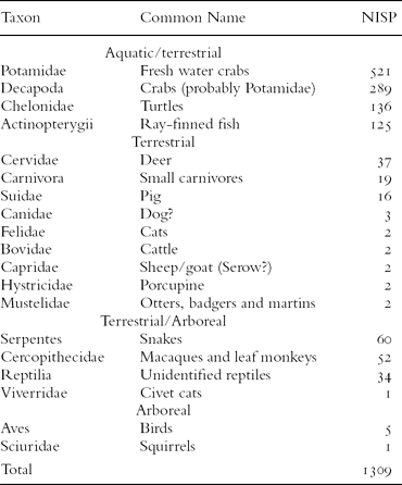
Post-excavation analysis of the fauna is on-going and preliminary statements only can be made at this early stage; however, it is already becoming apparent that a significant part of the total non-molluscan macro-invertebrate and macro–vertebrate remains will be identifiable to element and family or higher taxonomic level. This is largely due to the high proportion of decapods in the assemblage (Table 4). A sample of these has been studied by one of us (TN) with colleagues at the Raffles Museum of Biodiversity Research, University of Singapore. Initial findings suggest that the remains are of freshwater crabs from the family Potamidae. There is a possibility that lowland dwelling parathelphusids (Ng and Kosuge, Reference Ng and Kosuge1995) may also be present at Hang Boi, but none has yet been confirmed. Sampled specimens from the Upper Cave are from a single, recently defined genus Villopotamon sp. (Dang and Ho, Reference Dang and Ho2003; Yeo and Ng, Reference Yeo and Ng2007). Although it has only been possible thus far to carry out a very limited comparison to modern freshwater crab fauna living in the area around Hang Boi, the modern specimens we have identified come from a different family, Varunidae (Yeo, pers. comm.). Exploring this potential difference and its significance will be a focus of future work.
Combined NISP totals of identified non-molluscan macro-invertebrate and macro–vertebrate remains taken from a total of n = 2317 fragments analysed from all contexts: (5003) to (5013), Upper Cave midden, Hang Boi.

Among the vertebrate fauna, preliminary work by one of us (PP) on the Chelonian remains indicates the presence, among other taxa, of Cuora trifasciata (the Chinese Three-striped Box Turtle) and Cyclemys dentata (Asian Leaf Turtle) – both of which are commonly found in small water-courses in upland environments (Bonin et al., Reference Bonin, Devaux, Dupré and Pritchard2006). Fish remains appear well represented and include pectoral spines, vertebrae and cranial elements; detailed analysis of this material, though, has yet to be undertaken. Among terrestrial and arboreal mammals deer (almost certainly Cervus unicolor and Muntiacus sp.) are represented; Sus sp. is also present, as are bovids and caprids. Cranial remains from two specimens of Arctonyx collaris (Hog Badger) have been identified from within the Upper Cave midden in contexts (5005), sq.226/108 and (5013) sq.226/109W. Cercopithecidae are also present, with species of macaque currently the most well represented. None of the vertebrate taxa can be considered abundant in comparison to the molluscan remains. However, cut-marks have been identified on several elements, including a Sus sp. 5th metatarsal and cuboid, a 4th carpal from a large cervid (likely C.unicolor), the distal humerus of a Cercopithecidae and the distal femur of a chelonid, indicating that many of these bones are likely the result of human butchery activities despite their low frequency.
The ecology of these taxa offers some insight into the nature of the local environment around Hang Boi during its use. Of the cervids represented, both suggest the existence of forest in the vicinity of the cave and the strategies of acquisition geared towards game with differing forage and activity cycles. Cervus unicolor (Sambar) tend to be crepuscular and nocturnally active and browse in wooded areas. Muntiacus sp. (Muntjak) is another browser, though it prefers to feed close to the edges of forest or in abandoned clearings in upland areas. It is more active during the day than the Sambar (Lekagul and McNeely, Reference Lekagul and McNeely1988; Payne and Francis, Reference Payne and Francis1998).
Macaca arctoides (Stumptailed Macaque) is considered an upland forest species, and one which still inhabits Tràng An (Rabett, pers. observation). It is sympatric with Macaca nemestrina (Pig-tailed Macaque) and elements from both have been found at Hang Boi (comparisons made at Natural History Museum, London). Unlike M.fasiciularis, M.nemestrina is not generally known to inhabit coastal forests. If this is the sub-species M.n.leonina (the Northern Pig-tailed Macaque), as the modern distribution of the species suggests, it is likely to have been almost exclusively arboreal; a feature that will have had implications for the technologies needed to acquire it. The fact that some fragments of bone and, notably crab and turtle remains, are evidently burnt further supports the interpretation that this midden has a likely anthropogenic origin. The presence of small nodules of what appears to be burnt clay may further attest to this conclusion, but the exact origin of these finds is not known as aside from the superficial area of ash and charcoal described above, no hearth-like features or lenses of ash were encountered during work this season. Overall, the composition of the fauna from the Upper Cave midden at Hang Boi bears considerable similarity to that found at Hoabinhian sites in this and neighbouring provinces, notable for their riverine and terrestrial resource focus. The age that we can now attribute to these remains is also consistent with this interpretation, though as yet, diagnostic lithics have not been recovered.
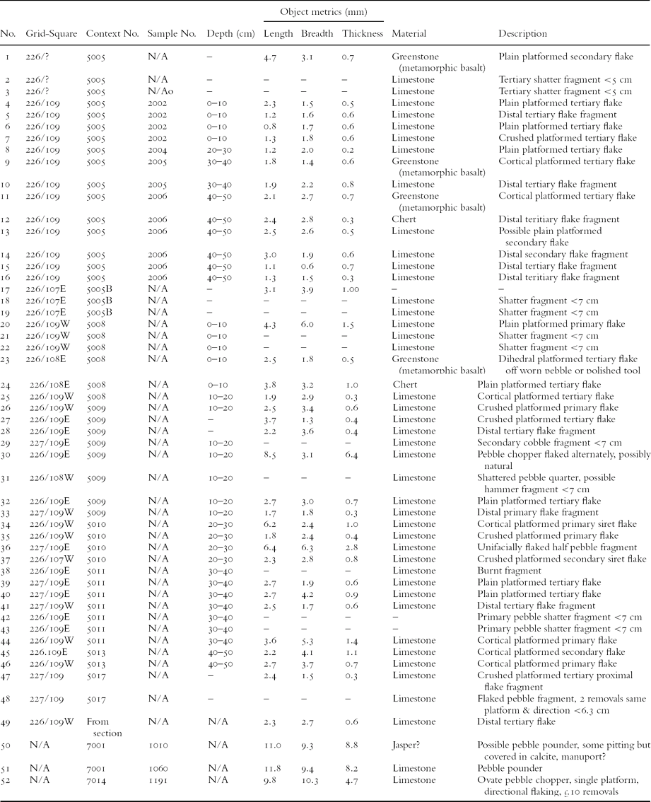
Of the lithic pieces deemed likely the products of deliberate manufacture, 49/52 came from contexts in the Upper Cave midden (Table 5). This small collection shows evidence of hard hammer reduction using local limestone and the occasional introduction of exotic materials. These exotics tend to be worked pebble tools and may have been introduced already manufactured. There is, as yet, no sign of in-situ knapping – micro-debitage has not been seen in either the bulk sample or flot (1 mm mesh) materials. The edge damage observed is consistent with slight crushing pressure being applied to the pieces when deposited. This could possibly be attributed to foot traffic in the past, but evidence from the completeness of mollusc shell remains does not seem to be consistent with any significant trampling, except in small localised patches across the site. The presence of two siret flakes might suggest use of large stone hammers for flaking. They do not refit and so represent separate flaking events. The lack of burnt worked material could suggest no pattern of retooling based around a hearth which is common in other regional contexts. The assemblage, if representative, probably reflects minor, low intensity activity in which the use of stone artefacts was occasional and situational. Curation is possible for the exotic materials, which must have been introduced, but the remaining material is un-retouched, bears no use polish and little trace of functional use wear. There is no sign of preferential blank manufacture or selection, no systematic reduction patterns or platform preparation has been identified. Alone, this small collection has limited research potential. Further excavation that recovers a larger sample may well alter this.
Lithics analysed from Upper and Lower Cave contexts, Hang Boi. Glossary: primary flake – a flake retaining cortex over the entire dorsal surface; secondary flake – a flake retaining some cortex on the dorsal surface; tertiary flake – a flake without cortex on the dorsal surface; cortex – the outer cobble surface; siret flake – a flake that has split longitudinally down the flaking axis during removal; chopper – a unifacially flaked pebble tool; pounder – a heavy pebble exhibiting patches and pits of damage from use usually producing a wear facet; hammer – as pounder but with more localized damage and single wear facets are rare.

The Lower Cave
In the NW corner of the Upper Cave are two large shafts that rise higher than 15 m above the height of the cave mouth and open out below it into the Lower Cave (Fig. 2). It is likely that they originated as sink-holes in the hill-top behind the cave, but these cannot be seen from inside the cave. Relict flowstone ledges and a remaining fragment of suspended cave floor demonstrate that the floor of the Upper Cave once continued into and beyond the area now occupied by the shafts. Both shafts evolved through a process of stoping and collapse of the Lower Cave roof. It should be possible in the future to establish the age of this collapse through dating of the relict flowstone and of newer formations which have developed subsequently. An aven is developed in the roof of the back of the Upper Cave and below it a gully-like feature is incised through ancient shell-midden deposits and drains into the first shaft. These features suggest that at some time in the past waters came through the aven and poured into the area now occupied by the shaft, perhaps contributing to its collapse. Spectacular flowstone drapes have formed on the walls of both shafts, but recent stoping is evident in a number of areas where flowstone is absent and fresh rock is exposed.
The shafts merge as they descend onto the Lower Cave 18.23 m below and provide the point of access (now via a metal stairway) from above. As Fig. 2 shows, the Lower Cave is a very large bell-shaped cavity with smaller side chambers, the more inaccessible parts of which have yet to be explored in detail. Originally, the principal cavern would have been 40–50 m high, today it is mostly infilled with talus, but the surviving roof is still c. 20 m above the top of this. Phreatic domes on a surviving area of the chamber roof suggest that the Lower Cave is of phreatic origin and gives on to at least one substantial (4–5 m diameter) phreatic tube.
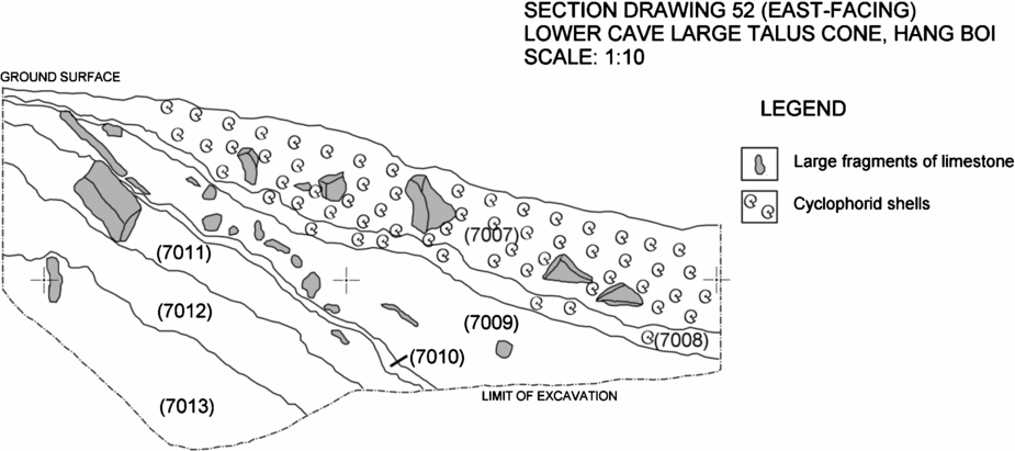
The chamber is mostly occupied by two active talus cones. The larger cone originates below the shafts in the back of the cave mouth. A small test-excavation into its deposits showed that they are stratified (Fig. 4). The surface is strewn with loose debris that includes huge blocks of angular limestone, remnant shell midden and occasional pebble tools. Scatterings of wood, bamboo and modern pottery indicate that the talus has been added to in the more recent past by people visiting the cave.
Section drawing showing stratified deposits in the large talus cone, Section 52, Lower Cave, Hang Boi.

The surface material overlies stratified thin shell-midden deposits, then brown silty-clays and then light-brown clayey silts. The silty nature of the lower layers in this excavation was identified as being loessic (wind-blown dust) in origin. Comparison with other dated loessic deposits in caves throughout Southeast Asia suggests that loess blew out of the China Plateau during stadial episodes of the last glacial period. The last loessic episode was during the Late-Glacial, which ended 11,500 calendar years ago (Gibbard and van Kolfschoten, Reference Gibbard, van Kolfschoten, Gradstein, Ogg and Smith2004). These stratified loessic deposits clearly postdate the collapse of the chamber roof, which therefore lies at the latest before the end of the Late-Glacial. The presence of false-floors (flowstone layers originally laid down on sediments, which have subsequently been eroded away) and partially-cemented and now hanging shell-midden deposits on the sides of the Lower Cave are clear evidence for pauses in the evolution of the talus cone at times in the past.
Of particular note is one, massively thick (over 1 m.), flowstone false-floor (designated the ‘Platform’ by this project) is overlain by an area where natural and archaeological materials accumulated in a gour-pool (an area of water bounded by a precipitated calcite rim). In May 2007, the pool area was dry, when the site was briefly re-visited in November, 2007 it was found to be full of water and is, therefore, part of a still-active hydrological system. Materials in the pool were partially encrusted with cauliform calcite precipitated from the water, and comprised small and moderately-sized fragments of limestone, animal bone and land and freshwater snails, and crab elements. The calcitic formations were often confined to a single surface, suggesting that many of these materials have remained in-situ since their original deposition.
The distribution of shell, stone and bone/carapace indicated that the only size-sorting evident in the accumulation had been caused by the gentle run-off of standing water from the Platform to another gour pool through a small hole in the limestone. The articulated nature of some skeletal elements and the excellent state of preservation of some of the large mammal bones suggest against accumulation here from the roof collapse. That these agents should include human activity is supported by the occurrence of cord-marked earthenware sherds (n = 15) attributed (by one of us, NCT) to the Da But culture and, therefore, c. 6.5–5.5 kbp (uncal.) in age. However, whether this material indicates a human presence in the cave at that time or was introduced at a subsequent date(s) is presently unclear. The possibility of a, now blocked, lower cave entrance remains to be investigated. The entirety of the Platform was planned, photographed and surveyed, and approximately 1/3 excavated for the retrieval of cultural materials and sedimentary and environmental samples.
Well-preserved remains of Sus sp., Cervus sp. and Cercopithecidae from the Platform are associated with cyclophorid and camaenid land snails and the large freshwater bivalve Cristaria herculea. Bones from a range of small vertebrates were also recovered. Analysis of these, and the likely agents of their accumulation in the gour-pool, is currently being conducted by one of us (CS). It has, thus far, been determined that there are at least three genera of microchiropteran bat using the cave today: Hipposideros spp. (confirmed, Hipposideros diadema), Rhinolophus sp., Miniopterus sp. This compares to Hipposideros diadema, Rhinolophus sp., Miniopterus sp. and Taphozous sp. so far identified in the archaeological assemblages. Potamid specimens from the Lower Cave may belong to more than one genus. Tiwaripotamon sp. has been identified with reasonable certainly. Little is known about its ecology, but at least one species from Vietnam (Tiwaripotamon edostilus) has been found to inhabit caves, though their adaptations to a cavernicole existence are only apparent in their long legs (Ng and Yeo, Reference Ng and Yeo2001). Other possible genera represented include, Hainanpotamon sp., Villopotamon sp., Indochinamon sp. and Larnaudia sp. (Yeo and Ng, Reference Yeo and Ng2007). Given that the gour pool is still liable to periodic filling it is possible, on these data, that some of the potamid specimens recovered from here may be part of naturally occurring cave fauna.
The second and much smaller talus cone (designated, ‘Area B’ by this project (Fig. 2) originates below a small shaft which lies below the surviving roof area of the Lower Cave adjacent to the foot of the access stairway. This shows similar loessic deposits to the main talus cone, but capped by a thin flowstone (that has been sampled for dating) and then loose shell-midden material. From the location and form of this talus it was clear that the deposits were not associated with the main roof collapse. Inspection of the area suggests that the talus is the result of material falling through a solution hollow from the Upper Cave. The excavation of a small section of these deposits indicated that though re-deposited, the deposits were stratified. The upper, loose shell layer overlaid thick mid-reddish brown sediment almost devoid of cultural remains. Underlying this was a clayey silt layer containing large numbers of land snails and from which was retrieved one well-preserved limestone ‘chopping’ tool.
Conclusions
The Xuan Truong/University of Cambridge project at Tràng An is providing an excellent opportunity to carry out a detailed landscape-use study integrating archaeological (likely Hoabinhian) remains with climatic and environmental data from the surrounding environs. This will help construct a detailed understanding of how Late Pleistocene and Early Holocene populations adapted to the challenges of the sustained and significant inundation caused by rising sea levels, and landscape and resource transformations that occurred along the edges of the northern Sunda plains.
The dating evidence suggests that occupation associated with the development of a >2 m thick midden in the Upper Cave at Hang Boi was comparatively intensive from at least c.12 cal. kbp, until the midden accumulation ceased and possibly the site was abandoned some time soon after c.10.5 cal. kbp, after which time the midden was capped by flowstone. The total depth of the midden has not yet been established, but it certainly extends into the Late Pleistocene. No evidence was found to suggest that an occupation of similar character in the Upper Cave recommenced above the level of the flowstone; however, the presence of several Da But pottery fragments in the Lower Cave does suggest low levels of human activity within the cave during the Mid-Holocene.
The terrestrial and riverine nature of exploited resources excavated from the midden, together with three AMS radiocarbon dates begin to suggest that the principal occupation took place at a time when the local stretch of the Song Hong was a meandering river and Tràng An was anything up to 60 km from the palaeo-coast. Human groups occupying the site included a significant amount of freshwater animals within their diet. However, this procurement strategy did not involve the gathering of sufficient freshwater molluscs to have provided a significant number of calories; land snails dominate the molluscan assemblage. The fact that only two species of cyclophorid make up the majority of the midden is further indication of deliberate selectivity on the part of foragers in the face of a comparatively wide variety of potential prey species. While groups visiting the site were clearly targeting a range of different local forest and river habitats, and possessed the necessary technologies to procure game from them, at least elements of their foraging appear to have been undertaken in a specifically targeted manner. The apparent cessation of any significant occupation at the very beginning of the Holocene, when the region around Tràng An was increasingly taking on the characteristics of a maritime margin, is of considerable interest. The uppermost part of the midden requires more refined dating, but on the coarse evidence of our range-finding dates, it appears to belong to a time when the local Song Hong was developing a more brackish water, estuarine, character. At this time the northern Sunda plains and the modern river delta were beginning to be inundated by the sea. Whether and how this shift in local palaeogeography can be linked to the abandonment of the cave is a matter for on-going study. However, it is apparent that the presence of a marginal marine environment in this area may not have been compatible with the persistence of pre-existing settlement or economic systems. The preliminary evidence from Hang Boi suggests that human adaptation to the environmental changes at the end of the Last Glacial were more complicated and situational than simple economic opportunism might predict. The exploitation of marine margins, widely considered amongst the richest of environments, may not have been feasible or desirable in this case, even when they lay close to the cave. Although the origins of Mid-Holocene settlement along the northern coast of Vietnam may lie with the descendents of the inland Hoabinhian, the current picture from Hang Boi, if it represents a Hoabinhian occupation, supports the position that exploitation of coastal resources by such communities was minimal. In order to help further clarify this picture, the project's research programme will include isotopic study on samples of land snails from the site to determine if a seasonal occupation signature can be confirmed. In the field, additional sites were reconnoitred in November, 2007. One of these, Hang Trõng (‘Empty Cave’), located c.1 km SSE of Hang Boi, contains abundant surface land snail scatters and material culture, and will be the focus of parallel excavation work in forth-coming field seasons.
Acknowledgements
None of the work undertaken during this field season would
have been possible without the constant support provided
by our Vietnamese sponsor: Mr Nguyen Van Truong. Members
of his staff were willing and enthusiastic assistants
on-site and looked after us extremely well. Sincerest
thanks therefore go to (among many others), Ngô Thi Huy,
Đôʾ Thị Tuyêʾn, Dào, Hà, Cuo ng, Diêʾn and Thắm. Particular
thanks must go to the British Embassy for its logistical
assistance. Discussions with distinguished figures in the
Ninh Bình People's Committee, the Ministry of Culture,
Sports and Tourism, the British Embassy and École
Française D'Extrême-Orient helped us to begin to place our
work within the wider context of development in Ninh Bình
province and Vietnam generally. We are very grateful for
the generosity and encouragement that all have shown us.
We wish to extend sincere thanks to, most notably, Vu The
Long (Institute of Archaeology of Vietnam), Darren Yeo and
Peter Ng, (University of Singapore); also Matthew Collins,
Kirsty Penkman (NEaar Laboratory, University of York); the
14CHRONO Centre, Queen's University,
Belfast; Daphne Hills (Natural History Museum, London) and
Peter Pritchard (The Chelonian Institute, Florida). Many
thanks also to David Gilbertson for reading and commenting
on earlier drafts of this paper, and to the two reviewers
for their valuable feedback. Partial funding for this
field-season was provided by the D. M. McDonald Grant
Fund, University of Cambridge, and the John Templeton
Foundation (grant no. 1104/RG45799), their assistance is
gratefully acknowledged.