NORFOLK
(1) Hockwold cum Wilton/Weeting-with-Broomhill (TL 756 872): Stage 1 of an Aerial Investigation and Mapping (AIandM) survey of Breckland.Footnote 57 The existence of an important Roman period site on the north bank of the Little Ouse has been known for many years, through the recovery of numerous finds, small-scale excavations and aerial photographs. The site has been interpreted as both a settlement and a religious or cult centre, the latter in part due to the recovery of a cache of priestly headgear (a crown and five diadems) from the site. The site is bisected by the linear earthwork known as the Fossditch (Scheduled Monument 1004040 ‘Devil’s Dyke (Fossdyke or Fendyke)’), which is thought to be a post-Roman territorial boundary. Excavation of a section of the earthwork within the Hockwold site demonstrated a post-Roman date for this segment at least.Footnote 58
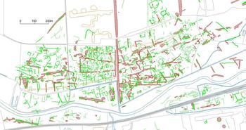
The survey used a wide range of aerial photographs together with Environment Agency LiDAR to identify, map and record the cropmarks and earthworks visible at the site. The clarity and density of features meant that it was possible to map the site in great detail. The results highlight the internal organisation of the site, and the exceptionally high number of timber buildings present. The largest building has a rounded apsidal eastern end and could possibly indicate an early church or chapel site. Others may represent barns, and could feasibly reflect a centralised agricultural role, perhaps focused on grain storage. A number of small sub-circular features, probably each comprising a structure around a sunken area, perhaps relate to corn-drying ovens, kilns or similar structures. Many are located alongside the roads dividing the site internally.
The aerial sources have also revealed extensive new evidence of roads, enclosures and boundaries surrounding the site, indicating a substantial settlement and associated landscape (fig. 27). As well as features extending westwards towards the fen edge, and eastwards towards Weeting Heath and Thetford Forest, this includes fragmentary areas of earthwork enclosures and boundaries newly identified on the Suffolk side of the Little Ouse, to the south of the site. These are associated with previously recorded Roman building material and finds. Much of this evidence for the wider landscape is undated. The features mapped by the project represent a palimpsest, which almost certainly encompasses not only several phases of Roman activity but features from earlier and later periods as well. However, the character and cohesion of the settlement and its surrounding landscape suggest a broadly contemporary, Roman period date for much of what is visible. The apparent survival of some of the features as earthworks is potentially significant, in a part of England where earthworks of any date are comparatively rare.Footnote 59
Mapping extract showing the Hockwold/Weeting site (just left of centre) within its wider landscape; banks and mounds shown in red, ditches and pits in green. Note the Fossditch running along the eastern edge of the site. (Graphics by Sarah Horlock and Sophie Tremlett. Base map © Crown copyright and database rights 2019 Ordnance Survey 100019340. Archaeological mapping © Historic England)

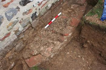
(2) Reedham, St John the Baptist church (TG 4278 0249): further to the excavations of 2016,Footnote 60 five more 2 m by 1 m trenches were excavated in 2017 and 2018, two of which produced evidence of Roman structures. The first, abutting the north face of the tower, produced a small area of coursed foundation material consisting of roughly dressed, unmortared blocks of stone, the great majority of Leziate from north-west Norfolk, and sealed by a mortar spread. The second, located on the south side of the nave towards its eastern end, revealed the lower courses of a mortared, curved wall employing Leziate stone and edged with Roman bricks faced with a mortar render (fig. 28). It was partly sealed beneath the wall of the nave. The badly robbed foundations of a second wall, aligned east–west and consisting of loosely mortared flint and Roman brick, were discovered c. 1.2 m to the south of the curved wall. A third trench at the east end of the nave on the north side produced evidence of a mortared surface which sealed charcoal giving two mid-seventh- to mid-eighth-century a.d. radiocarbon dates; the fourth trench against the south face of the tower revealed modern disturbance down to the natural.Footnote 61
Reedham, St John the Baptist church: curving Roman wall sealed by the south wall of the nave, view from south-west.

SUPPLEMENTARY MATERIAL
For Supplementary Material for this article please visit https://doi.org/10.1017/S0068113X19000400