Introduction
Loess is defined as a terrestrial sediment formed by aeolian accumulation of mainly silt-sized particles, especially during Pleistocene cold dry phases (Pye, Reference Martignier, Nussbaumer, Adatte, Gobat and Verrecchia1995; Muhs, Reference Muhs2013) and aggregated by loessification (Sprafke and Obreht, Reference Rudnick and Gao2016). Thick loess deposits can be used as an archive to decipher Quaternary climate changes and landscape development on local and regional scales (Frechen et al., Reference Finke2003; Antoine et al., Reference Antoine, Rousseau, Fuchs, Hatte, Markovic, Jovanovic, Gaudenyi, Moine and Rossignol2008; Jary, Reference Jary2009; Badura et al., Reference Badura, Jary and Smalley2013; Sprafke et al., Reference Rubinić, Galović, Husnjak and Durn2013; Sprafke et al. Reference Rubinić, Lazarević, Husnjak and Durn2014; Jary and Ciszek, Reference Jary and Ciszek2013). Thick loess covers have relatively uniform texture of silt loam throughout, with small variations of particle-size distribution, in particular of coarse/fine silt and fine sand contribution. These variations are interpreted as sedimentological changes (e.g., wind strength/activity or source areas; Mason and Jacobs, Reference Mason and Jacobs1998; Mason, Reference Kryza and Pin2001; Stanley and Schaetzl, Reference Stanley and Schaetzl2011; Újvári et al., Reference Újvári, Kok, Varga and Kovács2016) or post-depositional alternations. On the contrary, thin loess deposits or loess derivates may contain coarser or finer components that blur the original silty texture (Frolking et al., Reference Frechen, Oches and Kohfeld1983; Karathanasis and Macneal, Reference Kabala, Bekier, Bińczycki, Bogacz, Bojko, Cuske and Ćwieląg-Piasecka1994; Schaetzl, Reference Muhs and Benedict2008; Schaetzl and Luehmann, Reference Schaetzl and Luehmann2013; Schaetzl et al., Reference Norton and Franzmeier2016) or even hide the original aeolian nature of the material (Schaetzl and Loope, Reference Schaetzl and Loope2008; Stiles and Stensvold, Reference Stiles and Stensvold2008; Martignier et al., Reference Lindbo, Rhoton, Bigham, Hudnall, Jones, Smeck and Tyler2015; Munroe et al., Reference Mason2015). Thin loess and loess-derived covers (<0.5–1 m thick) are often ignored in geological maps, which may confuse many users, including soil scientists. Schaetzl and Attig (Reference Munroe, Attwood, O’Keefe and Quackenbush2013) have shown the importance of detailed mapping of thin loess covers and the influence of thin and turbated loess deposits on pedogenesis in northeastern Wisconsin.
The distinction between loess and underlying materials has special importance during the investigation and mapping of thin loess covers. In some cases, loess is clearly separated from the older materials by a sharp contact line (lithological discontinuity), whereas in other cases the thickness of loess is unclear above the diffused contact or mixed zone (Semmel and Terhorst, Reference Pye2010; Schaetzl and Leuhmann, Reference Schaetzl and Luehmann2013). The problem is particularly important and often reported in mountainous areas, where even small additions of aeolian silt can have a significant influence on soil formation and properties (Litaor, Reference Kida1987; Muhs and Benedict, Reference Muhs and Benedict2006; Munroe et al., Reference Munroe, Farrugia and Ryan2007; Kufmann, 2008; Geitner et al., Reference Geitner, Schäfer, Bertola, Bussemer, Heinrich and Waroszewski2014; Lin and Feng, Reference Kierczak, Pedziwiatr, Waroszewski and Modelska2015).
The region of Lower Silesia (southwest Poland) is largely covered with loess and loess-like sediments of a highly variable thickness (Jary, Reference Jary1999a; Kabala and Marzec, Reference Jary2010; Kabala et al., Reference Jary2015). The thicker covers, in most cases 3–5 m and maximally up to 15 m thick, occur as isolated patches (Jary and Ciszek, Reference Jary and Ciszek2013), whereas much thinner (0.3–2 m) loess-like deposits prevail in the region (Jary, Reference Jary1999a). Such thin and scattered loess-derived deposits surround Mt. Ślęża, an isolated mountain massif situated in the flat landscape of the Silesian Lowlands. The loess deposits overlie glacial outwash materials and weathering products of gabbro, serpentinite, and granite. Although the massif is surrounded by loess, the silt loam texture of soils on the slopes of Mt. Ślęża has often been explained by in situ physical and chemical weathering of the underlying bedrock, with a few authors suggesting allochthonous silt addition to soils (e.g., Weber, Reference Schaetzl, Smidt, Liu, Kincare, Walkowiak, Thorlund and Holler1982; Żurawek, 1999; Kabala and Jezierski, Reference Jary2011; Kierczak et al., Reference Kabala and Jezierski2016). The general and universal question is how to recognize the aeolian additions to mountain soils if the loess cover was eroded or mixed with underlying regoliths and formed slope cover deposits.
This paper evaluates the possible contribution of aeolian silt to the soils on the mountain slopes of Mt. Ślęża, where silt loam soil texture prevails or is very common, using geochemical and textural data. Furthermore, a set of slope covers is described as representing typical interactions of loess and underlying bedrock, and providing parent material for soil formation.
Study area
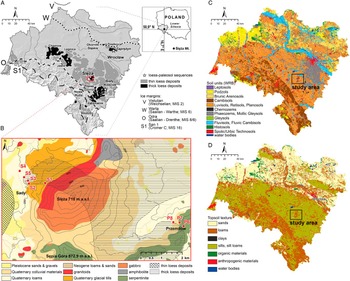
Mt. Ślęża (715.5 m asl; Fig. 1A and B) is the most northerly body of the Fore-Sudetic Block (the northernmost tectonic part of the Sudeten Mountains) that is subdivided into two geological units: (1) the Ślęża ophiolite and (2) the Strzegom-Sobótka Massif. The first unit hosts mostly ultrabasic rocks: metagabbros, serpentinized peridotites. ultramafic cumulates, diabases, and metabasalts (Kryza and Pin, 2010; Kierczak et al., Reference Kabala and Jezierski2016), while the second unit is comprised of Variscinian granitoids. Figure 1A gives an overview on the loess distribution and glacial advances in Lower Silesa. The maximum advance of the Scandinavian ice sheet probably occurred during Marine Isotope State (MIS) 16 (Polish San 1, NW-European: Cromer C; Marks Reference Labaz and Kabala2011). Additionally, during the MIS12 period (Polish, San; northwest European, Elsterian; Cohen and Gibbard, Reference Cohen and Gibbard2011), the Scandinavian ice sheet covered almost all the Silesian Lowland and the Sudeten Foreland was covered by ice, which reached a thickness of 500 m (Hall and Migoń, Reference Galović and Peh2010). The maximum ice advance during the Saalian (Polish, Odra) is attributed to MIS 8 or early-middle MIS 6 and covered the Silesian Lowland and Sudeten Foreland up to an elevation of 300 m asl (Badura and Przybylski, Reference Badura and Przybylski1998; Marks Reference Labaz and Kabala2011). The glacial deposits on the slopes of Mt. Ślęża are mainly related to the Odra glaciation (Żurawek, 1999). MIS 6 and the later glaciations did not reach the study area. Finally, the entire area was covered with aeolian silt during the last glacial period (Polish, Vistulian; Jary, 2010). The deposited loess is associated with the existence of the Great Odra Valley in front of the last glacial ice sheet (Badura et al., Reference Badura, Jary and Smalley2013). The thickest loess sediments in this area (>9 m) are reported in Księginice Małe, east of the Mt. Ślęża (Krajewska, 1994; Kida, 1999a), but the thickness of loess is most commonly less than 2 m. The age of the lowermost part of the loess-sequence in Księginice Małe was attributed to MIS 5a–b (Jary, Reference Jacobs, Mason and Hanson2007). The original vertical extent of loess accumulation on slopes of Mt. Ślęża is unknown and impossible to reconstruct due to intense erosional processes that occurred in the Pleistocene as well as in the Holocene as a result of intensive clearance for settlements and agriculture (Żurawek, 1999).
(color online) Study site location including extent of glaciations (A), geological setting (B) of Mt. Ślęża, distribution of soil types (C), and texture (D) in the Lower Silesia province.

Most of the soils developed from loess and loess-like materials in Lower Silesia (Fig. 1C and D) are characterized by subsurface clay illuviation and are classified as luvisols or related units (Kabala et al., Reference Jary2015, Kabala and Musztyfaga, Reference Kabala and Musztyfaga2016). In the central flat and moist part of the loess region, soils with thick humus horizons occur and are classified as chernozems and phaeozems (Labaz and Kabala, Reference Labaz and Kabala2014). The low- and midslope sections of Mt. Ślęża (mostly afforested) are occupied by luvisols (Kabala and Jezierski, Reference Jary2011), while cambisols and leptosols predominate on the upper slopes (Kierczak et al., Reference Kabala and Jezierski2016).
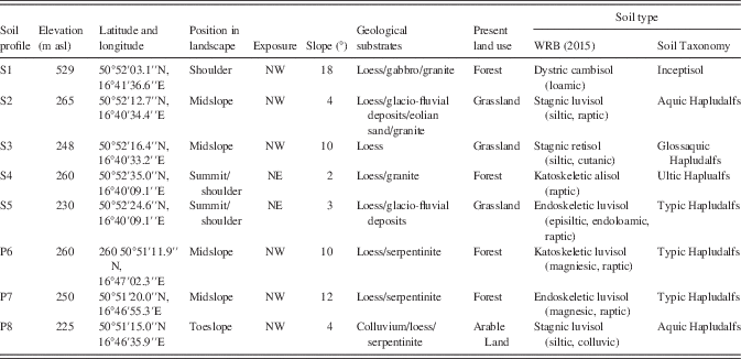
METHODS
Soil sampling and description
Eight soil pits on 2 slope catenas in the lower part of Mt. Śleża were investigated, where loess addition to soils was highly probable (Fig. 1B). The catena Sady is situated on the western slope and consists of 5 soil profiles (S1–5) on granite or gabbro bedrock or glacio-fluvial sediments. The catena Przemiłów consists of 3 soil profiles (P6–8) located on serpentinite bedrock (Fig. 1B). Each soil pit was dug until the underlying bedrock was reached or no visible changes in the lithology were observed down to the depth of 200 cm. Soil layers and genetic horizons were distinguished and described according to the Guidelines for Soil Description (FAO 2006). Soil horizons were characterized considering their depth, colour, texture, structure, type and percentage of rock fragments and presence of carbonates. We paid special attention to lithological discontinuities and the occurrence of mixed zones between loess-derived and underlying materials. Soils were classified according to FAO-WRB system (IUSS Working Group WRB, 2015) and Soil Taxonomy (Soil Survey Staff, 1999). Approximately 1–2 kg of soil material was taken from each distinguished soil horizon. Samples were air dried, gently ground, and passed through a 2 mm sieve.
Particle size distribution and geochemical analyses
Prior to the analysis of particle-size distribution, the soil material was passed through a 1 mm sieve to separate the very coarse sand fraction, composed mostly of minerals having a platy shape (serpentine, mica), which may blur the relation between the silt and sand fraction. All collected samples had low organic matter content and were free of carbonates, thus no additional pre-treatment was required. Samples were dispersed by addition of Na-hexametaphosphate and stirred for 4 h. Three replications were performed to obtain statistically reliable data (Miller and Schaetzl, Reference Miller and Schaetzl2011). Particle-size measurements were performed using a Malvern Mastersizer 2000 diffractometer with a Hydro MU dispersion unit (Malvern Instruments) by adding a small representative amount of the soil material to ensure an adequate range of obscuration (10–20%). The results from laser diffraction were deemed unsatisfactory in soil profiles having serpentine input (clayey material) as well as in other samples from argic horizons, because of a significant underestimation of clay content, even up to 30%. Therefore, we decided to use a hydrometer-sieve method (Van Reeuwijk, Reference Schaetzl and Luehmann2002) for all samples to provide more accurate and comparable results in materials with a broad textural range.
Chemical analyses of 57 bulk samples were performed using ICP-ES and ICP-MS after sample fusion with lithium borate and an alloy dissolution with nitric acid (ACME Labs). The analytical reproducibility (2-sigma), as estimated from replicate analyses of 8 randomly chosen samples ranges from 0% (Al2O3) to 15% (Zr) at 95% confidence limits. Analytical accuracy (2-sigma), as estimated from 9 measurements of reference sample SO-18 is from 0.2 (SiO2) to 7.1% (Ni) at 95% confidence limits. Further geochemical calculations based on relatively immobile elements (Ti, Hf, Zr, Nb, Ce, and Y) that have relatively high ionic potential and are considered as chemically immobile in most of the near-surface environments (Hutton, Reference Geitner, Schäfer, Bertola, Bussemer, Heinrich and Waroszewski1977; McLennan, Reference Litaor1989, Reference Lin and Feng2001; Muhs and Benedict, Reference Muhs and Benedict2006) and are considered as markers of aeolian silt contribution (Scheib et al., Reference Scheib, Birke and Dinelli2014). The ratios and bivariate plots of these elements (Ti/Zr vs. Ti/Nb, Zr/Hf, and TiO2 vs. Ni) were derived to: (1) evaluate an aeolian contribution to the soils, (2) differentiate the soil substrates, and (3) estimate the thickness and properties of mixed zones of aeolian materials with underlying substrates (Fig. 1B, Table 1).
Main characteristics of studied sites.

RESULTS
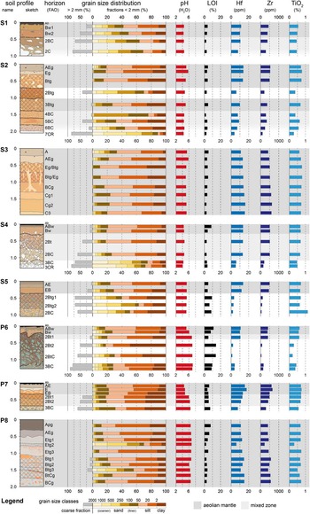
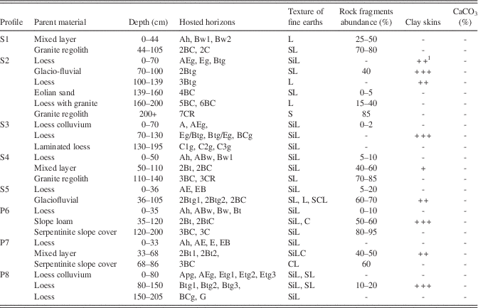
Based on morphological (Table 2), textural (Fig. 2), and geochemical data (Table 3), the studied soils were grouped into five clusters showing different soil profile development, but always with silt loam layers of a various thickness, partly mixed with the underlying material. These are: (1) thick silt loam beds; (2) multi-stratified slope beds with thick silt loam layers; (3) shallow silt loam layers, sharply separated from underlying materials; (4) shallow silt loam mantles with mixed zones to underlying material; and (5) silt enriched mixed layers over bedrock.
(color online) Depth plots of selected basic (grain size distribution, Ph, and LOI) and geochemical (Hf, Zr, and TiO2) properties in studied soil profiles.

Morphology and basic properties of soils under study.

1 Abundance of clay accumulation: none (-), weak (+), medium (++), and high (+++).
2 Both layers consist very thin sandy loam strata not highlighted as a separate bed due to their thickness.
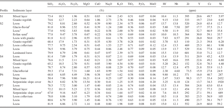
Major and trace elements in distinguished layers (mean values)

1 Data taken from individual samples only.
Case 1: thick silt loam beds
Thick silt loam layer soil profiles were identified in the slightly concave midslope in the Sady catena (profile S3) and in the toe slope of the Przemiłów transect (profile P8). At S3, three different layers of loess-related materials can be distinguished (Table 2). Despite different morphological features, all layers in the profile S3 consist of nearly uniform material (at least down to the depth of 195 cm), with a clear dominance of the silt fraction (60–75%) and a stable relation between coarse to fine silt (Fig. 2). Only the material from the C3 horizon shows significantly higher content of coarse silt; this variability is typical for the Lower Silesian loess (Jary, Reference Jary1999b). Also, the mean concentrations of SiO2 (79.9–76.6%), TiO2 (0.77–0.71%), and stable trace elements like Zr (601–469 ppm) and Hf (15.6–12.5 ppm) confirm the homogeneity of this loess profile (Table 3). The whole profile is free of coarse fragments (gravel or stones) and only in the topsoil are coarser sand fractions present in significant amounts. The topsoil material interpreted as colluvial material has features of a humus horizon throughout, whereas clay illuviation occurs between 40–100 cm, testified by the presence of a well-developed argic Bt horizon.
Profile P8 also has a homogenous texture of silt loam throughout, with silt dominating (63–79%) and fine silt dominating over coarse silt (Fig. 2). However, two thin coarser-textured (sandy loam) layers break the profile homogeneity, at a depth of 70–78 and 141–150 cm (the latter contains angular fragments of serpentine). Colluvial loess in the upper layer has clearly higher clay content and lower content of sand compared to loess trapped between the coarser strata (Fig. 2). Geochemical parameters (e.g., Ti, Zr, and Hf) confirm the similarity of the silt loam textured layers (Table 3). It should also be noted, though, that the highest concentration of Ni in the topsoil indicates colluvial loess with input from serpentinite outcrops in the upper (eroded) slope. Clay enriched lamella with sufficient thickness to qualify as an argic horizon were recognized at the depth of 105–170 cm.
Case 2: multi-stratified slope beds with thick silt loam layers
Profile S2, in a comparable position to S3 (midslope), is characterized by a clear silt loam (60–73 % of silt) mantle of ca. 70 cm thickness. Two further layers, significantly enriched in silt, can be traced down to a depth of 200 cm (Table 2). The upper two silt-enriched layers (0–70 and 110–139 cm), are separated by glacial sediments. The silt-enriched layers are free of coarse fragments and clearly contain a higher content of very fine sand. The glacial sediment hosts ca. 40% of rounded and subrounded gravels, mostly Scandinavian red granites. The layer of glacial sediments has a very firm consistency and platy structure that suggests it is of periglacial origin. Boundaries between silty layers and the glacial material are abrupt and erosional. Sandy sediments with a weak stratification separate the middle from the lowermost silty horizon, equally showing sharp boundaries. The sandy material is nearly free of coarse fragments and has two maxima in its particle-size distribution, (1) fine and very fine sand and (2) clay, while silt content is 4 times lower than in the overlying material (Table 3). The underlying layer has a texture of loam and significant coarse fraction of angular granite fragments. The high content of silt indicates an aeolian origin, as the basal granite regolith has very low content of this fraction (extremely skeletal sand texture class, Fig. 2). The different origin of particular layers and overall stratification of the profile are clearly evidenced by geochemical data. In particular, Hf and Zr are significantly higher in the silt-enriched strata (Table 3).
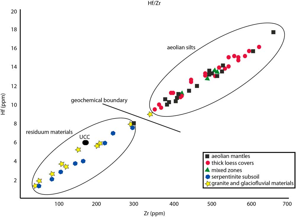
(color online) Plot of Hf vs. Zr, comparing silt loam substrates with underlying materials. Standard for Upper Continental Crust was taken from Taylor and McLennan (1985).

Clay cutans are well developed between a depth of 40 and 139 cm, creating a very thick argic diagnostic horizon; however, particular sublayers may represent different stages of clay illuviation. This is evidenced by different kinds of clay and silt-clay cutans on aggregates, as well as bleached tongues, which interfinger the sublayers with variable intensity.
Case 3: shallow silt loam layer sharply separated from underlying materials
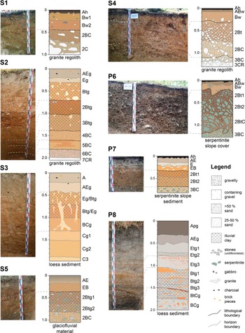
Profiles S5 and P6 are examples of silt loam mantles that directly overlie the bedrock/regolith (coarse- or fine-textured materials), without any transitional layer. An abrupt lithologic discontinuity is present at the contact of those two substrates (Fig. 4). Such surface mantles are usually thin (35–36 cm) and have a clear silty character. The content of the silt fraction ranges between 52 and 76% (Fig. 2) and the sand fraction is dominated by very fine sand. Coarse fragments are present in the surface silty cover, but their abundance is very low (5–10%, maximum 20%). Despite the different underlying materials, the lithological discontinuity is well-marked in both profiles by differences in coarse fragment content, texture class, and geochemistry.
In profile S5, subsoil layers contain 60–70% of gravel fragments, mostly rounded reddish Scandinavian granites and local serpentinites, which indicate a glacial origin for the layer (possibly short-range outwash transport). The texture of the fine earth fractions is variable and ranges between sandy loam, loam, and sandy clay loam, due to irregular changes in clay content. The silt content of the subsoil layers is much lower compared to the topsoil and ranges between 19 and 34%. In the sand fraction, coarse and medium sand dominate over the fine and very fine subfractions (Fig. 2). The underlying glacial material is clearly distinguished from the topsoil material by 3 to 6-times lower concentration of Hf, Nb, and Zr, and 2-times lower content of Ce and Y. The concentration of Ni is two times higher in underlying glacial (solifluction) material compared to the surface silt mantle, which reflects admixtures of local serpentinite bedrock. Also, the major elements (SiO2, Al2O3, and Fe2O3) point to a different origin of materials from the surface mantle and underlying layers.
In the profile P6, the content of coarse fragments abruptly rises in the subsoil to 50–60% and then to 80–95% (Table 2). The coarse fraction consists of slightly sub-rounded and angular serpentinite fragments of a local origin. Also, the texture of the fine earth fractions changes abruptly to clay and clay loam classes with clay content up to 49% (Fig. 2). The difference between the silty surface mantle and the underlying serpentinite material is easily detectable by the higher Hf and Zr contents; however, the strong impact of serpentinite bedrock is visible not only in the subsoil, but also in topsoil, as reflected by high Ni and Mg contents (attributed to periglacial mixing) throughout the soil profile (Table 3).
The surface silty mantle comprises humus-enriched and eluvial horizons, whereas clay cutans are absent (profile S5) or present only in the bottom part of the silt mantle (profile P6). However, in the underlying layers, i.e., below the lithological discontinuity, thick clay cutans are very abundant either on structural soil aggregates or on rock fragments.
Case 4: shallow silt loam mantles with mixed transitional zones to underlying sediments/regoliths
Profiles S4 and P7 illustrate the case where a silt loam mantle overlies clearly different bedrock/regolith, but the contact is transitional rather than abrupt and a sharp lithological discontinuity is absent (Fig. 2 and 4). Surface silt loam mantles have a thickness of 33–50 cm. The content of the silt fraction ranges between 53 and 73% and the sand fraction is dominated by very fine sand, as in other loess mantles (Fig. 2). Coarse fragments are absent or present in very small amount (up to 10%).
(color online) Detailed morphology of studied soil profiles including recognition of different parent materials and soil stratification.

The transitional zone in profile S4 has a thickness of ca. 60 cm and its upper boundary is indicated by a marked increase of rock fragments down profile, whereas the texture class of the fine earths remains a silt loam (Table 2). This means a similarly high content of the silt fraction (62–69%) and a lesser incorporation of sand compared to the overlying loess mantle (Fig. 2). At the bottom part (3BC horizon), the material becomes more sandy and less silty and clayey, thus the texture class of the fine earths changes to sandy loam (extremely skeletal). Hf and Zr have the highest values in the topsoil silt loam that harmonizes with the same finding in the other profiles and confirms the aeolian origin of the layer. All elements, both macro- and micro- (excluding P and Ni), have intermediate values in the transitional zone, which is an evidence of addition of loess to the native granite regolith.
The transitional (mixed) zone in profile P7 is ca. 35 cm thick and has apparently higher contents of serpentinite coarse fragments compared to the topsoil (Table 2). The texture class is silt clay loam with a low content of sand (dominated by the very fine subfraction) and a high content of the silt fraction (53–54%), retaining the silty character of the fine earth from the soil surface down to a depth of 65–70 cm. A sharp boundary separates the mixed material from the underlying compact, highly skeletal (serpentinite) slope deposits. As in the case of profile S4, maximum contents of Hf and Zr indicate the aeolian origin of the surface silty mantle. The distribution of most of the macro- and micro-elements argues for a transitional geochemistry within the mixed zone. Very high concentrations of Ni and Mg confirm the influence of serpentinite bedrock.
Clay cutans were commonly identified in the transitional (mixed) zones of both profiles that is in line with apparently higher clay content in these zones identified as Bt (argic) soil horizons. Clay cutans are absent in the surface silt loam mantles, where the transformation of color and structure, typical for a cambic horizon (Bw) is present (Table 2).
Case 5: Silt-enriched mixed layer over bedrock (no pure silt loam mantle)
Profile S1 is located on similar granite regolith to profile S2 and S4; however, profile S1 is in a slope position exposed to erosion. A pure silt loam mantle, free of rock fragments, is lacking (Table 2). The upper part of the soil profile has a texture of loam with a higher content of the silt fraction (up to 48%) and very fine sand domination (Table 3). However, the coarse fragment content reaches 25–50% of soil volume, which makes the layer similar to transitional (mixed) zones in profiles S4 and P7. Also, the Hf and Zr contents are at high level comparable with mixed materials enriched with loess in the other profiles (Table 3). The coarse fraction in the mixed zone consists of granite and gabbro fragments derived from outcrops located in the upper part of the slope, whereas the bottom part of the soil profile is developed in granite regolith. Fine earths of this extremely skeletal regolith have a texture class of sandy loam with a significantly lower proportion of silt and clay fractions compared to the overlying layers (Fig. 2). Clay translocation and/or accumulation have not been recognized in any soil horizon. However, color and structure transformations typical for cambic horizons are evident both in the mixed zone and the upper part of granite regolith.
DISCUSSION
Origin of surface silt loam textured layers
Loess materials are characterized by specific geochemical characteristics that can be verified by geochemical methods (Catt, Reference Catt1985; Taylor and McLennan, Reference Schaetzl and Attig1985; Sterckemann et al., Reference Scheib and Lee2006; Rudnick and Gao, 2003; Feng et al., 2011; Lin and Feng, Reference Kierczak, Pedziwiatr, Waroszewski and Modelska2015). Many authors have shown specific enrichments of aeolian silts with Hf and Zr (Buggle et al., Reference Buggle, Glaser, Zoeller, Hambach, Markovic, Glaser and Gerasimenko2008; Scheib and Lee, Reference Miller and Schaetzl2010). These elements have been successfully used as a proxy to detect even weak aeolian silt contributions to the soil (e.g., Muhs et al., Reference Mason and Jacobs2004; Galovic and Peh, Reference Frolking, Jackson and Knox2014; Lin and Feng, Reference Kierczak, Pedziwiatr, Waroszewski and Modelska2015). This specific feature of loess is probably related to the high resistance to weathering of zircon and baddeleyite, which are the main sources of Zr and Hf in aeolian environments (Feng et al., 2011; Ujvari et al., Reference Schaetzl and Loope2008). In general, the concentration of Hf and Zr in the Upper Continental Crust (UCC) does not exceed 6 and 190 mg kg-1, respectively (Taylor et al., 1983), whereas median concentrations of Hf and Zr in loess and loess-derivates presented by Scheib et al. (Reference Muhs2014), range from 8 to 14 mg kg-1 and from 237 to 453 mg kg-1 for Hf and Zr, respectively.
Thick silt loam materials in the profiles S3 and P8, and shallow silt loam surface mantles under investigation (Table 3), have Hf contents ranging from 9.5 to 15.6 mg kg-1 (mean 13.3 mg kg-1) and Zr contents between 371 and 602 mg kg-1 (mean 499 mg kg-1). This fits very well to the ranges typical for deep loess covers and loess derived materials (Scheib et al., Reference Muhs2014). Moreover, the silt-enriched materials in the transitional horizons, as in profiles S1, S4, and P7, have higher Hf and Zr concentrations compared to underlying regolith or glacial sediments (Table 3).
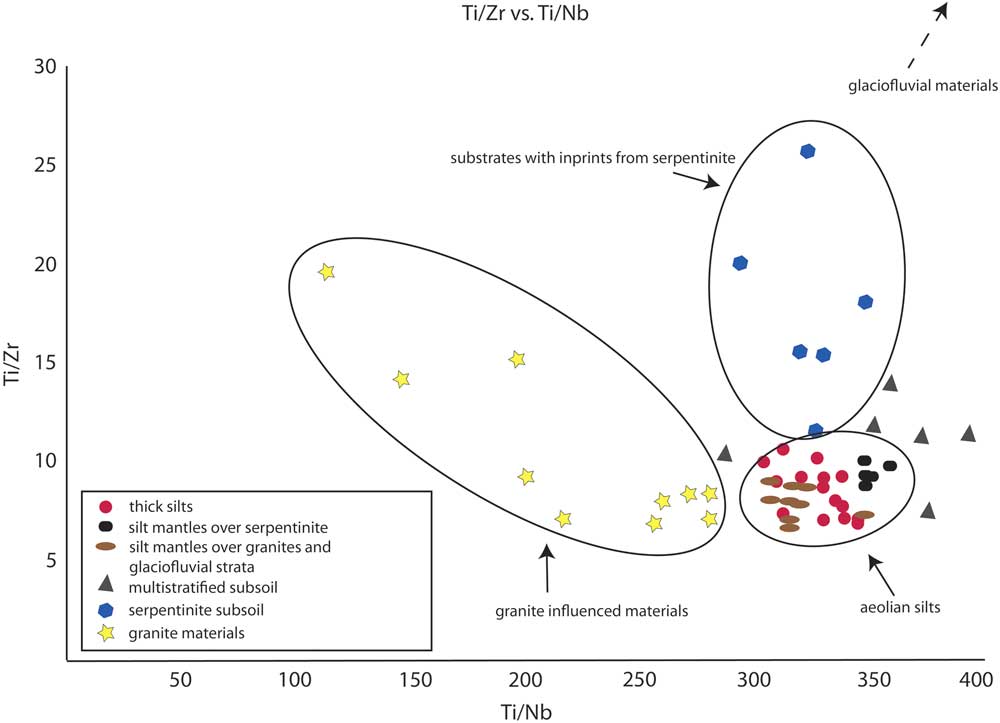
The specific nature of aeolian silt may also be illustrated by other relationships. Figure 3 shows a linear relation between Hf and Zr concentrations. Loess and loess-enriched materials are clearly aggregated in one cluster, while all other materials occur in the other cluster. The boundary between those two groups was found at ca. 9 mg kg-1 of Hf, related to ca. 320 mg kg of Zr. Particular materials, where the field characterization does not agree with geochemical data, are situated below the detected boundary (Fig. 5). This pattern may suggest that their mixed/transitional character was not clearly identified in the field. Although granite and serpentinite create different geochemical environments, their influence on the Hf and Zr indicators is negligible (Fig. 3). This confirms its value for indicating aeolian silt addition in mixed/transitional zones. Compared to serpentinite and granite, the same may also be concluded for the influence of glacial or glaciofluvial materials (Fig. 4). Based on these findings, an aeolian silt addition is also indicated for the mixed material in the surface part of profile S1, despite a strong textural impact of the granite bedrock (high content of coarse fragments and sand fractions; Table 2 and Table 3).
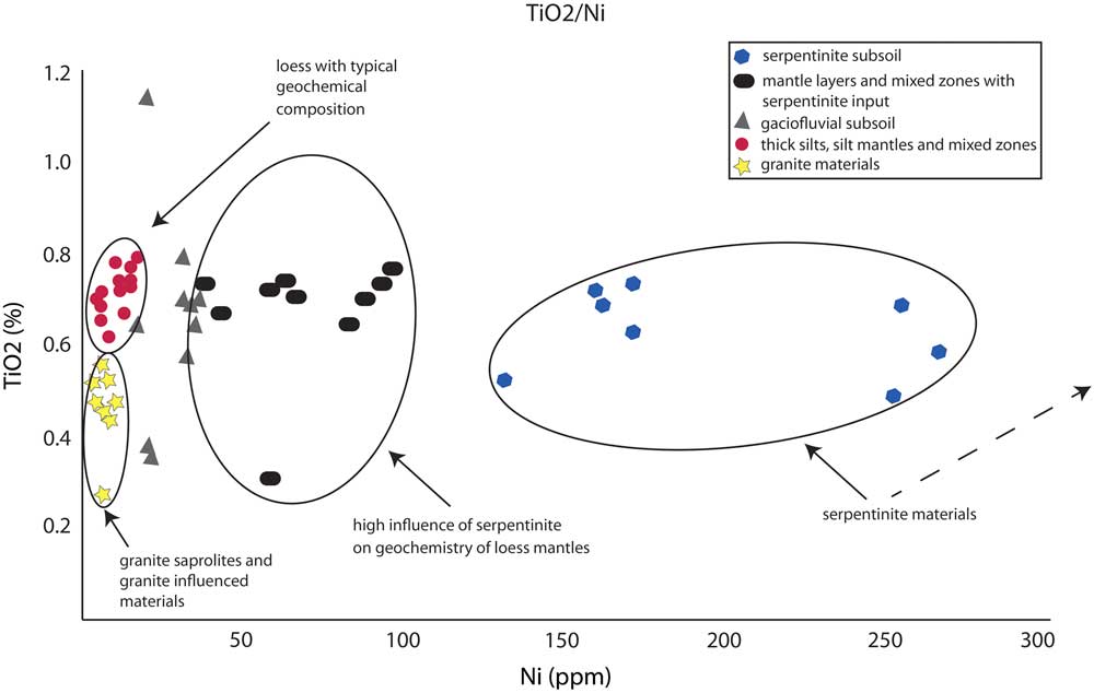
(color online) Plot of TiO2 vs. Ni (e.g., Ujvari et al., Reference Schaetzl and Loope2008), discriminating studied materials.

The other relative indices, derived in relation to the content of stable Ti content, help to distinguish the impacts of various bedrock types or underlying sediments. The bivariate plots of Ti and Ni (Fig. 5) clearly divide pure loess, granite regolith, and granite-loess mixed materials from the serpentinite materials. The transitional character of glacial and glacio-fluvial materials visible in this graph argues for a variable admixture of local serpentinite material to the glacial sediments. Also, the bivariate plot (Fig. 6) of the ratios of Ti/Zr and Ti/Nb permits separation of “pure” loess from the mixed materials, also providing information on the type of influencing bedrock.
(color online) Bivariate plot of Ti/Zr vs. Ti/Nb (Muhs and Benedict, 2006) for examined soil samples.

All the presented geochemical indices support the interpretation of an aeolian origin for the silt loam mantles and silt addition to mixed layers, thus a large impact of loess on the slope cover beds in the catenas under investigation. Some of the characteristics of the described slope covers fit very well to the Pleistocene periglacial cover beds concept, recently summarized by Kleber and Terhorst (Reference Kabala and Marzec2013).
Loess accumulation and formation of slope cover beds
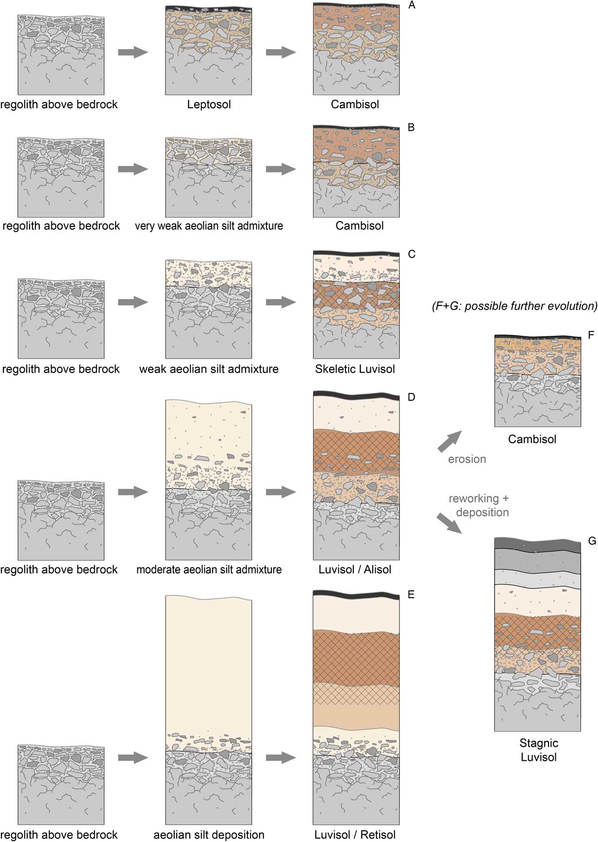
The large variability in the character of the slope cover beds (Fig. 4) results from many possible pathways for their formation (Fig. 7). Cover beds may have a combination of features developed under aeolian silt accumulation, periglacial slope mass wasting, glacial sedimentation, erosion, and colluvial accumulation (Table 2). Particular processes coexisted in the same periods that led to the development of mixing/transitional zones, or acted subsequently, which resulted in vertical stratification.
(color online) Hypothetical pathways of soil evolution resulting from variable aeolian silt admixture. No (A) or very weak (B) aeolian silt contribution result in Leptosol or Cambisol formation, while weak admixture (C) produces a loess mantle over fine sediments and Skeletic Luvisols could be developed. Moderate aeolian input (D) leads to formation of mixed zone and surficial loess mantle (Alisols/Luvisols). In deep aeolian silts (E) we observed transformation (tonging) of argic and thus Retisols present. Based on slope position further erosion (F) or colluviation (G) could result in formation of Cambisols of Stagnic Luvisols, respectively, as exemplified for pathway D.

Serpentinite, granite, and gabbro regoliths, if present at or near the soil surface during the early Pleistocene period, probably were removed by two extensive glaciations, and their remnants were mixed with Scandinavian materials transported by glaciers and reworked by slope processes (solifluction) during deglaciation or interglacial phases (Żurawek and Migoń, Reference Semmel and Terhorst1999). Therefore late-Pleistocene loess accumulation covered mixed slope loams (as in profiles P6 and P7) rather than pure regoliths (profile S1 and S2). It is, however, unclear, why relatively “pure” granite regoliths did survive through the Pleistocene, whereas the serpentinite regoliths did not. It is probable that the periglacial physical disintegration of the serpentinite produced fine-granular and relatively compacted regoliths that impeded the admixture of aeolian silt. Coarse textured granite regoliths, having a grus structure (Kajdas et al., Reference Jary and Ciszek2017), were mixed with aeolian fine materials, which raised their susceptibility to slope reworking (periglacial mass wasting). This is also connected with the unanswered question about possible early Pleistocene aeolian inputs to slope materials and regoliths, which could survive in a pure form (separate layers) or as additions to slope loams (Jary, Reference Jary1999b). Such early Pleistocene silt accumulation cannot be excluded, for example in profile S2, where the silt-enriched layers at a depth of 160–200 and 110–139 cm are covered with sediments of other origins (periglacial loams or fluvial sediments).
Another still-unresolved question is how long the original loess mantles survived in an unchanged form. Mixed/transitional zones (like in profile S1) testify to simultaneous loess accumulation and transformation due to slope processes. However, it may be supposed that some thicker mantles or loess layers that accumulated in protected landscape positions have not been reworked by slope processes and removed by erosion, but survived at least until the middle Holocene. This conclusion is based on the thick clay-illuvial (argic) horizons, present below recent colluvial mantles. The presence of silty colluvium indicates a recent phase of transformation, probably related to human impact including forest clearing and agricultural land use that accelerated erosion processes on slopes. Sharp transitions between surface dark colluvial mantles and underlying illuvial horizons testify for large-scale erosion that removed the original humus and eluvial horizons at most sites and replaced them with mixed colluvial material transported from the upper part of slope.
As a result of the aforementioned processes, five types of cover beds were identified on the slopes of Mt. Ślęża. Case 1 (profile S3) represents a thick loess cover that has no specific addition from the underlying bedrock (within the standard soil profile) due to its thickness. The loess mantle has survived relatively unchanged during the Holocene. However, late Holocene human impact resulted in erosion and colluvial accumulation. Case 2 (profile S2) documents a multi-stage accumulation of aeolian silt, starting with its mixing with granite regolith, probably contemporary to its accumulation. Silt accumulation took place here in 2–3 periods, interrupted by deposition of other materials such as slope deposits, tills, or fluvial sediments. The upper part of the profile is comprised of recent colluvial materials. This profile represents slope cover beds developed in landscape positions conducive to sediment accumulation and protected against erosion. Case 3 (profiles S5 and P6) is a cover bed consisting of a shallow silty mantle accumulated on the stable surface of eroded bedrock, regolith or mixed slope loams. The abrupt contact of the overlying loess and underlying materials indicates a lack of mixing by slope processes (e.g., periglacial mass wasting) during loess accumulation and testifies for stability of the land surface during silt accumulation. Case 4 (profiles S4 and P7) is a cover bed consisting of a shallow and relatively pure aeolian silt mantle accumulated on the unstable surface of underlying older materials. Unstable surface conditions (e.g., slope angle) result in highly active slope processes contemporary with loess accumulation, leading to mixing of loess and older slope materials. Case 5 (profile P1) was developed probably in the same way as case 4, but the surface “pure” loess mantle was completely eroded and the cover bed consists of the mixed, silt-enriched layer overlying the granite regolith. The second scenario explaining formation of the uppermost part of profile S1 is that it received minimal aeolian silt input (Fig. 7).
Loess accumulation and pedogenesis on mountain slopes
Typically, eroded regolith of various parent rocks on mountain slopes host weakly developed soils like leptosols or regosols, or cambisols in more loamy materials and more stable sites (Kabala et al., Reference Jary2015). However, loess accumulation changes the conditions for soil formation, as relatively porous and clay-rich loess provides materials susceptible for clay translocation, i.e. clay eluviation in the topsoil and illuviation in the subsoil (Norton and Fanzmeier, Reference Marks1978; Kabala and Marzec, Reference Jary2010; Szymański et al., Reference Scheib, Birke and Dinelli2011; Rubinić et al., 2015a, 2015b). Many authors provide detailed characteristics of soils with different morphological types of subsoil clay accumulation (Lindbo et al., Reference Karathanasis and Macneal1995; Szymański et al., Reference Schaetzl2012). They agree that the presence or absence of carbonates controls the first stage of soil evolution, as it plays a crucial role for the dispersion of clay particles, necessary for their further transport between horizons (Finke and Hutson, Reference Feng, Hu, Ju and Zhu2008; Finke, Reference Finke and Hutson2012; Drewnik et al., Reference Drewnik, Skiba, Szymański and Żyła2014). However, in soils having lower contributions of aeolian silt, but higher additions of bi-valent cations (e.g. magnesium) from serpentinite residuum, the clay dispersion and translocation may be hindered and may affect soil evolution pathways (Schaetzl and Leuhmann, Reference Schaetzl and Luehmann2013). Most of the soil profiles under study have horizons with well-developed illuvial clay features within the loess mantles and silt-enriched layers, even on eroded slopes. However, there is additional doubt whether the clay-illuvial (argic) horizon developed recently (as a genetic horizon of modern/surface soil) or is inherited from the older soil (previous soil formation phase). There are many arguments for multi-stage development of argic horizons, e.g., in profiles S2, P6, and P7. Even if a Holocene age is assumed for most of argic horizons, some of them are relic in the sense that, after forest clearing and land use changed to agriculture, the clay eluviation/illuviation was hampered. Presently, eluvial horizons are removed or blurred and replaced with thick humus or transitional cambic horizons (as in profiles S4 and P6). We speculate that the soils represented by case 5 (or soil profile S1) transiently had an argic horizon until the loess mantle (hosting argic) was completely eroded (Fig. 7).
As a result of aeolian silt accumulation or addition, which favors conditions for clay eluviation/illuviation processes, most of the soils on mountain slopes have to be classified as luvisols/skeletic luvisols, the most typical soil group with argic diagnostic horizon. The only exceptions are soils of the same type, but significantly more acidified (classified as alisols, profile S4) or having the features of secondary transformation/decay of argic horizon (retisols, profile S3). Based on the findings from the investigated profiles, it can be concluded that the development of luvisols as a major soil group was possible due to aeolian silt accumulation, but the pathways of soil formation and evolution are closely related to the thickness of the loess mantle (Fig. 7; Jacobs et al., Reference Hall and Migoń2012) or the extent of loess contribution to the slope cover bed.
CONCLUSIONS
Our study demonstrates that silt loam materials, which commonly occur over coarser or finer underlying sediments on Mt. Ślęża, have an aeolian origin. Geochemical data clearly distinguished material having different provenance (igneous, ultramafic rocks, glacialofluvial sediments, and aeolian deposits). The incorporated silts have a geochemical signature typical for loess-derived materials. The type of basal strata (serpentinite or granite) influences the formation and the depth of mixed zone (33–60 cm) and/or the presence of an aeolian mantle (33–70 cm). The presence of an aeolian mantle as well as the formation and depth of mixing zone is correlated with type of underlying material and is more pronounced on granite regoliths. Incorporation of aeolian silt in soils is the main agent initiating and stimulating clay translocation and formation of an argic horizon within mixed zones or just below the boundary between silt mantle and coarse/fine basal strata. Mixing loess with acid granite saprolites and further illuviation results in the formation of alisols, while contribution to serpentine strata results in development of skeletic luvisols. Stagnosols occurred on sites where former argic horizons were buried with eroded loess sediments, while in “pure” loess sediments we observed the decay of argic horizon and the formation of retisols. Soils receiving low input of aeolian silts in the Pleistocene remain as leptosols or cambisols.
ACKNOWLEDGMENTS
This research was financed by National Science Center (Poland) project nr 2014/15/D/ST10/04087 and 2014/15/B/ST10/04606. The authors are grateful to Okar Bojko, Leszek Gersztyn, Tomasz Bińczycki ,and Adam Bogacz for help during field work and to Monika Barańska for support in the laboratory. Randall Schaetzl, Nicholas Lancaster, Chase Kasmerchak, and one anonymous reviewer are appreciated for constructive comments that improved final version of the manuscript.
SUPPLEMENTARY MATERIAL
To view supplementary material for this article, please visit https://doi.org/10.1017/qua.2017.76