The history
The South Shetland Islands, lying off the Antarctic Peninsula some 900 km south of Cape Horn, were the site of the first known human habitation and exploitation of Antarctica. Their discovery in 1819 opened the way for the exploitation of the fur seals that bred there, bringing the Antarctic into the fur sealing trade which by that date was already global in scale (see Busch Reference Busch1985; Headland Reference Headland1984; Richards Reference Richards1982; Cumpston Reference Cumpston1968; Kerr Reference Kerr1976).
The first confirmed sighting of the South Shetland Islands (originally named the ‘New South Shetlands’) was made by the British mariner William Smith on 19 February 1819 while on a passage from Buenos Aires to Valparaiso in the brig Williams (Campbell Reference Campbell2000: 69–67). News of Smith's discovery was soon the subject of speculation in the ports of Valparaiso and Buenos Aires, and quickly reached New England (USA) and British ports. Even before Smith's discovery was officially confirmed, sealing captains based in Buenos Aires were in search of the new islands (see Stehberg Reference Stehberg2003; Pearson and Stehberg Reference Pearson and Stehberg2006; Zarankin and Senatore Reference Zarankín and Senatore2005; see Zarankin and Senatore Reference Zarankín and Senatore2007 for a more detailed background to sealing in the South Shetlands)
The intensity of sealing in the summers of 1819–1820 and 1820–1821 was such that the population of fur seals in the islands was dramatically reduced, and the first phase of sealing effectively ceased by 1827. In the 1822–1823 season James Weddell observed that the fur seals were becoming shy of man, and were avoiding the beaches where the massacre of seals had occurred. Weddell advocated that restrictions be placed on the taking of mothers with pups in order to make the industry sustainable, but there was no political or administrative framework within which such restrictions could be imposed (Weddell Reference Weddell1827: 140–142). By 1829 the naturalist James Eights observed of the fur seal that: ‘[t]his beautiful little animal was once most numerous here, but was almost exterminated by the sealers, at the time these islands were first discovered’ (Eights Reference Eights and Fanning1838: 209).
It has been estimated that 144 ship based sealing expeditions worked in the South Shetland Islands between 1819 and 1827, 120 of them in the first three seasons 1819–1822 (see Pearson and Stehberg Reference Pearson and Stehberg2006 for a detailed analysis). The overwhelming majority of the ships were from either New England ports or from Britain, though at least two came from the Australian colonies.
There is no ‘authorised’ figure for the total number of seal skins taken during the height of the sealing boom at the South Shetland Islands, but working from figures reported in surviving journals of ship and limited customs and shipping information, the catch for 1819–1827 was at minimum 300,000 skins, and may have been as high as 800,000 and 900,000 skins (see Pearson and Stehberg Reference Pearson and Stehberg2006 for further analysis). There is no estimate of the total amount of elephant seal oil obtained.
A handful of vessels sealed opportunistically in the South Shetlands in the 1830s and 40s while en route to other sealing or whaling grounds, and American sealers worked the islands in the early 1850s and again in the 1870s, when approximately 40,000 skins were taken. Nova Scotian sealers took advantage of the slight recovery of seal numbers by the first decade of the twentieth century (see Pearson and others Reference Pearson, Stehberg, Zarankín, Senatore and Gatica2008).
The documentation of these voyages is generally limited to a basic record of ship movements into and out of ports. Only about twenty logs or journals of the first sealing era are known to survive, and only the journals describe sealing activities in any detail, most of them in manuscript form in US and British libraries. It this context of limited historical documentation, the archaeological record adds significantly to the information base about the nineteenth century sealing activities.
The sealing sites
Because of the rugged coasts and wild seas of the South Shetland Islands safe anchorages for sailing vessels were extremely limited in number, so sealing crews were dropped ashore by boat and left for periods ranging from days to months, and on at least two occasions, by mischance, for over a winter (in the case of sealing crews from the Lord Melville in 1820–1821, and the Florence in 1876–1877). These men were, coincidentally, the first humans to winter in Antarctica, and not the explorers of turn of the century as is generally reported. Once ashore the men built shelters in caves, against cliff faces, or on open beaches, piling up dry stone walls and roofing them with beams made of timber brought ashore from the ship or whale ribs from skeletons scattered on the beaches, the beams being covered with tarpaulins or seal skins. Roofs were formed by simply laying the beams horizontally from wall to wall, with no evidence of any attempt to build frames or trusses, or to use internal posts to support a ridge. This method limited the width of the huts to the length of the available roof beams, the shelters generally having maximum spans of 3m or less, and in a few rare examples the shelters extended up to 5 m in length. In some sites there are multiple structures, presumably to house larger crews and their gear.
Over 50 sealing sites have been identified by Chilean, Argentine, British, and Australian researchers over the past 50 years, several sealer structures have been excavated, and a programme of systematic survey of the islands continues (see Pearson and Stehberg Reference Pearson and Stehberg2006; Stehberg Reference Stehberg, Pearson, Zarankín, Senatore, Gatica, Barr and Chaplin2003; Zarankin and Senatore Reference Zarankín and Senatore2005; Reference Zarankín and Senatore2007; Pearson and others Reference Pearson, Stehberg, Zarankín, Senatore and Gatica2008). Surviving sites include occupied caves. On little visited islands (such as Rugged Island) caves have been located that have been completely undisturbed by humans from the 1820s until surveyed and excavated in recent years. One located by the authors in 2005 had timber artefacts and seal skin moccasins lying on the surface, and bottles scattered around the fireplaces (Pearson and Stehburg Reference Pearson and Stehberg2006). In more frequented areas (such as at Byers Peninsula) caves are obvious to visiting parties and have been extensively disturbed, as in the case of Lima Lima cave (Zarankin and Senatore Reference Zarankín and Senatore2007). Some caves have stone walls constructed across the rear section to provide more shelter for the occupants. The stone walled structures against cliff faces and on open beaches are often largely undisturbed (but see below), the cultural deposits and collapsed roofs being buried in wind blown sand. Occasionally large objects are also found embedded in the sand, such as a wooden sledge excavated in 2007 (Pearson and others Reference Pearson, Stehberg, Zarankín, Senatore and Gatica2008). The largely undisturbed nature of the sites reflects the isolation of the islands and the very low rate of human visitation after the sealing era.
The sealing sites of the South Shetland Islands represent an unusually intact and little disturbed archaeological resource that has high research and historical significance. The sites were part of a truly global industrial enterprise, and are a part of the world's heritage. However the protection of the sites and their conservation is complex, and a range of natural and human factors threaten them and create challenges for their protection under the Antarctic Treaty system. None of the sealing camp sites in the South Shetlands are currently included in the list of Antarctic historic sites and monuments identified under the Antarctic Treaty process.
Threats to sealing sites
There are a number of threats to survival the sealing sites in the South Shetlands.
Accelerating tourism
While the South Shetland Islands and the adjacent Antarctic Peninsula experience approximately 98% of the over 46,000 tourist visits (2007–2008 figure) and over 220,000 individual landings per year in the Antarctic, visitation is limited to a relatively small number of sites that are safely approached by ships and able to be landed on easily. The vast majority of beaches containing nineteenth century sealing sites have never been visited by tourists. However, this pattern seems to be changing as overall visitor number increase, and more landing sites are needed to accommodate the demand. The 151 landing places visited in 2003–2004 grew to 202 landing places visited in 2007–2008, the highest number yet recorded.
Tourism is very carefully managed and monitored, but it seems likely that limits will need to be placed, through the mechanisms of the Antarctic Treaty Organisation (ATO) and the International Association of Antarctica Tour Operators (IAATO), on overall number of both ships and tourists within a very few years if visitor numbers keep increasing at the dramatic rate they have over the last decade (from about 10,000 in 1997–1998 to 46,000 in 2007–2008, and more than doubling since 2004–2005 (IAATO 2008).
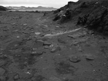
The presence of sealing era remains is known on several sites visited by tourists, but observations by the authors and others are that these remains are not being adversely impacted by tourist activities. However, a comprehensive survey or monitoring programme has not yet been carried out on all current and potential tourist landing sites. A risk is that, with increasing tourist pressure adding to the number of landing places being visited, more sealing sites will be included. As the sealing sites are almost always with 100 m of the shore and are often difficult to identify, there is the possibility that sites and artefacts will be inadvertently damaged or destroyed. However, this risk could easily be overstated. The elephant seal try works at Yankee Harbour on Greenwich Island was recorded by Pearson in late January 2008, a season in which 4,000 tourists were landed on the site from 17 ships. A total of nearly 19,000 tourists have visited the site since 2000. The situation of the try pot and try works have changed over time, being partly covered with sand in 1997 (observed by Senatore and Zarankin), and in 2008 being more exposed (observed by Pearson). While visitors can and do walk over the tryworks site if guides do not warn them of its existence, the site itself and the numerous fragments of brick and other artefacts scattered around the site survive in situ, and tourist activity does not appear as yet to have had a major impact on the site (Fig. 1).
Yankee Harbour try works site with broken try pot in the background. The site experiences high tourist visitation.

The try pot is reasonably obvious and is indicated by photograph and map in the Yankee Harbour Visitor Guide developed recently for the ATO (ATO 2008), but the tryworks is less easy for visitors to recognise and interpret and is relatively fragile. Pre-landing briefing and on site supervision by guides appears to be critical to the long term survival of this site. Visits by tourists in private sailing yachts and motor cruisers is increasing each season, and this sector of tourist visitation does not necessarily have knowledgeable guides or relevant literature aboard. Several of these vessels are self described ‘research vessels’, and have collected archaeological material from land and shipwreck sites. IAATO's report to the Antarctic Treaty Consultative Meeting in 2007 indicated that not all private vessels were authorised to land, or aware of the need to have applied for permission to their respective national authority (IATTO 2007). The location of the Yankee Harbour site adjacent to the most used landing site makes it a useful site to monitor for visitor impacts on sealing sites into the future.
As new landing places are opened up to tourism it would be advisable to have them surveyed by archaeologists, so that landing sites and recommended tourist routes are located so as not to have an impact on archaeological sites, where possible.
Disturbance by scientific researchers and national parties
By far the most intensive and extensive human presence in the South Shetland Islands is represented by the scientific parties undertaking research work within the framework of the Antarctic Treaty system, and the station staff, military personal, support crews and scientific parties maintaining national assets and territorial presence throughout the archipelago. Because the South Shetlands and the adjacent peninsula is the most accessible Antarctic region, it experiences a high proportion of the seasonal occupation by scientific parties in Antarctica. This is most intensive around the 16 permanent stations, occupied by 13 countries, many all year round, but occupation can extend during the summer to refuges, field camps or ship based landings on almost every island in the archipelago. While several of the areas with most known sealing sites are protected as Antarctic Special Protected Areas (ASPAs) (such as the Byers Peninsula and Cape Shirreff), there are as yet few guidelines to control the activities of parties in relation to cultural sites, and in many cases the presence and location of sealing sites is not identified in any documentation provided to parties, even in the management plans for the ASPAs (see discussion below).
In the 1950s and 1960s parties of geologists and naturalists identified many sealing sites, and in several cases were directed to ‘investigate’ these, informally excavating several sites on the Byers Peninsula, for example (see Lewis-Smith and Simpson Reference Lewis and Simpson1987). This work was well intentioned and resulted in the first documentation of the sites, but it effectively and extensively disturbed several of the most important sites in the area. Many of the important objects collected then were poorly recorded and documented, and can no longer be found in the collections of the relevant agencies. Sensitivity to the research and conservation potential of archaeological sites has increased in recent decades, but there are still problems in the mechanisms available to control damaging activities.
More recent archaeological work has continued to have an impact on some sites, as in a case on the Fildes Peninsula on King George Island, where a stone cairn erected to support a sign to indicate the presence of a site was recorded by a later archaeologist (after the sign had blown away) as an additional component of the original site. In another case an excavation was left open in anticipation of a following season of work that did not take place, leaving the deposit unprotected. These two cases were inadvertent, and not unique to Antarctica. There has also been a case of a binational archaeological expedition dividing the resulting historical artefacts between the two parties, with their future study and housing being on different continents, a less than ideal approach to research management.
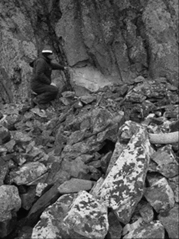
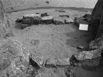
A recent example of impacts attributable to scientific field parties is the work of a geological party noted by the authors near the main field camp site on the Byers Peninsula, Livingston Island, in early 2007. The geologists, a year or two previously, appear to have levelled part of the dry stone wall of a hut built against a cliff to provide a elevated base from which to drill core samples from the cliff face above the site. The hut site (Vietor 1) was very obvious, being a square structure of 3 m × 3.5 m, with 1 m wide stone walls standing to a height of up to 800 cm, and with whale ribs (used as roof beams) within and adjacent to the structure imbedded in fallen stones. The site was also described in several journal articles in Spanish and English. The cliff, which extends on each side of the hut site, would have provided similar access for core sampling without disturbing the cultural site. The sealing sites are specifically identified as protected components of the ASPA covering this area, but this information is clearly not filtering down to those working in unrelated scientific fields. Indeed it has been observed by the authors that not all field parties are well briefed about the protected areas they are visiting, and Antarctic Treaty parties generally need to exercise their responsibility to ensure their own groups are better informed (Fig. 2).
Vietor 1 sealing shelter. Hut wall and whale bone rafter to right, and hut interior to left. The rear of the shelter appears to have been levelled to allow the drilling of core samples.

In addition to ASPA management plan requirements, all human occupation sites created before1958 are officially protected until fully researched and assessed (ATCM 2001), but guidelines to implement that blanket protection have not yet been developed in a form that can be provided as information to field parties.
On a more positive side of the presence of national parties is the evidence at the Fildes Peninsula, where the much visited shipwreck site on the beach near Uruguay's Artigas Base appears to have survived well, probably because of its proximity to the base, and the various sealing shelter sites on the northwestern coast do not seem to have been disturbed by visitors in over a decade of regular observation.
An initiative by the Programa de Gestión Ambiental of DNA Argentina sets what might be a useful precedent for scientific and work parties. The Argentine programme, for briefing research and military members going to the Antarctic, includes a mandatory course providing, among other things, information about proper behaviour at historic sites. Members of Antarctic parties need to pass the course to be allowed to go south.
Animal activity
The threat to sealing sites from animal activity is relatively minor compared with that from human activity, although several sites recorded in the 1990s on the Byers Peninsula were very hard to discern in a 2007 resurvey of the area due, in part, to elephant seal disturbance.
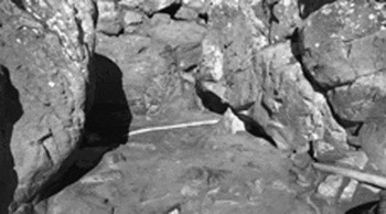
A number of sealing sites have been impacted by the actions of elephant seals and also by penguins. Elephant seals sleep and sometimes wallow in cultural sites, because they offer sharp edged stones and timber that can be scratched against to remove irritating skin during the annual moult. Elephant seals (which can be 5 m long and weigh up to 3.6 tonnes) also move across sites as they travel along the beaches or across them to melt water pools further inland, disturbing stones and artefacts as they pass (Fig. 3).
The polished stones of the collapsed front wall, and disturbed whale bone beams at Punta X shelter site, a favoured sleeping spot for elephant seals.

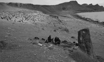
The build-up of penguin guano can bury sites, and erosion of soil destabilised by breeding birds can bury artefacts or allow soil to be washed away, sometimes impacting whole sites that are located on or near rookeries. A number of sites on Macquarie Island located on rookeries or in penguin movement corridors, for example, have been disturbed by erosion or buried in excrement (Townrow Reference Townrow1989: 143). The recent excavation of a partially buried sledge on the Byers Peninsula was deemed prudent due to erosion of the site, located on the edge of a rookery (Pearson and others Reference Pearson, Stehberg, Zarankín, Senatore and Gatica2008.). The potential also exists in rookeries and wallow areas for chemical damage of cultural materials through interaction with animal excrement and the raising of pH levels (as observed on Macquarie Island) (Fig. 4).
The sledge being excavated at Punta Diablo 2 site, where erosion related to access to the adjacent rookery has impacted on the site.

To date problems relating to penguin activity have not been observed to any great extent in the South Shetlands, as few identified sealing sites are located within rookery areas. Disturbance by penguins is much less of a threat to sites than is that by elephant seals.
Drifting sand
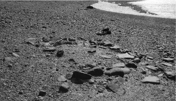
Drifting sand has partially buried much of the cultural material at most sealing sites, and thus protected it for nearly 200 years. However, in a few cases the comparison of early 1990s and 2007 survey evidence indicates that less obvious sites, with low or dispersed walls (sometimes the result of seal movement) can virtually disappear under sand drifts. This is not necessarily a conservation problem, and can in fact protect sites from some other threats, but it makes it essential that the sites are well surveyed and can be relocated for monitoring or research at a later date. Recent surveys have used GPS data to provide more accurate location information for sites, and previously identified sites are gradually being resurveyed using GPS. These locations are being placed on new editions of maps for the region being prepared by the Chilean cartographic office, and will be progressively added to the GIS driven mapping system as they are provided by future surveys (Fig. 5).
Punta Diablo 1 site, where animal movement and drifting sand have combined to make the site very hard to identify.

Climate change and coastal erosion
The major risk factors for sealing sites in the South Shetland Islands related to climate change are an acceleration of coastal erosion, and changes to microclimates encouraging growth of damaging fungi and algae and favouring increased corrosion of metal items. These conservation problems have been previously documented on the sub-Antarctic Macquarie Island and Heard Island (Lazer and McGowan Reference Lazer and McGowan1989; Townrow Reference Townrow1989) and climate change is likely to make them a conservation issue in the South Shetlands in coming years. The risks observed on the sub-Antarctic islands were:
coastal erosion, undercutting sites located close to the water's edge; a number of sites have been destroyed in this way at both Macquarie and Heard Islands,
proximity to the shore causing salt spray to soak artefacts and the ground, accelerating corrosion of metals and the breakdown of wooden artefacts,
algal growth on timber encouraged by the permanently damp conditions.
Coastal erosion can be accelerated by both sea level rise and by the reduction in the duration of sea ice formation, which protects the coastal zone seasonally from extremes of storm surge and wave action. This type of erosion, linked to warming conditions associated with climate change, is being experienced in the Arctic where, for example, Inuit and European historic sites on low lying Qikiqtaruk (Herschel Island) in the Canadian Arctic have been destroyed and others are increasingly at risk (Olynyk Reference Olynyk, Barr and Chaplin2004, Reference Olynyk and Colette2007). The degradation of permafrost as a result of increasing soil temperature is also a problem being observed in the Arctic, but the extent and likely impact of this factor in relation to the South Shetland Islands sealing sites has not yet been determined (but see Hauck and others Reference Hauck, Vieira, Gruber, Blanco and Ramos2007 for permafrost distribution). The sealer's shelters have no foundations, and so are less likely to suffer major distortion from differential ground movement, though increased instability of surface sands and ground slumping linked to permafrost degradation may become a conservation issue in the future (Fig. 6).
Playa Sur site, showing the proximity of the site to current sea level, reflected in the adjacent lagoon.

A number of recorded sealing sites in the South Shetlands are at, or only a little elevated above, sea level, and typically sit on loose sandy shorelines. These conditions make these sites extremely vulnerable to sea level rise or increased intensity of wave action. These sites are also at risk from the accelerated chemical and biological deterioration that may accompany increased salt spray, moist conditions and increased temperatures.
Challenges in the conservation of sealing sites
Antarctic management context
The unique operation of the Antarctic Treaty means that no one nation is automatically responsible for the management of particular sites in Antarctica. In the case of the heroic era huts, being the Mawson, Scott, Shackleton, Borchgrevink and Nordenskjold huts, the buildings themselves are the property of particular nations, and that largely determines who has responsibility. The same applies to later Antarctic bases and related field stations. However, in the case of the nineteenth century sealing sites, no national claims of ownership have been made for the sites or objects, and the Antarctic Treaty sets aside the overlapping claims of sovereignty over the South Shetland Islands maintained by Britain, Chile and Argentina. While archaeological research has been carried out by various countries, no serious conservation efforts have yet been initiated in the South Shetlands, and it remains to be seen if such work will be initiated by any of the treaty parties, or whether other parties might object to (and hence veto) such work as overtly strengthening sovereignty claims.
Many of the known sealing sites are within Antarctic Special Protected Areas (ASPAs), such as the Byers Peninsula and Cape Shirreff areas on Livingston Island. The management plan for ASPA 126 on the Byers Peninsula (SCAR 2003) recognises that: ‘. . .the archaeological values were described as unique in possessing the greatest concentration of historical sites in Antarctica, namely the remains of refuges, together with contemporary artifacts, and shipwrecks of early nineteenth century sealing expeditions’. Management at Byers Peninsula aims to ‘. . .allow archaeological research and measures for artefact protection, while protecting historic artefacts present within the Area from unnecessary destruction, disturbance, or removal’.
Entry into the ASPA is prohibited except in accordance with a permit issued by an appropriate national authority. Conditions for issuing a permit to enter the area include that ‘the actions permitted will not jeopardise the ecological, geological, historical or scientific values of the Area’.
The observation of the authors is that the intent of the ASPA management plan is made less effective than it could be because the locations of sealing sites, which are not always obvious to casual observers, are not specifically listed in the plan. This may have resulted in the serious disturbance of a site for geological sampling described above. It is also not apparent that every scientific party working in the area is familiar with the constraints imposed by the ASPA management plan.
We would argue that ASPA management plans that include policies to protect cultural sites (as in the case of that for the Byers Peninsula) should more clearly specify protective mechanisms that can be integrated into activities taking place on those sites. The location of cultural sites to be protected should be specifically identified in the management plans, and it needs to be clearly stated that these sites are not to be disturbed. Sites in non protected areas (that is not in ASPAs) need to be identified in other documentation accessible to all ATO parties, such as site guidelines, recently developed mainly for tourist parties, but equally valid for scientific and national parties. This form of information could include the guideline on protecting pre 1958 human occupation sites referred to above.
Options for protection of sealing sites in the South Shetlands were discussed by the authors at the first regional meeting of the international polar heritage committee of ICOMOS (International Council of Monuments and Site) representatives of the southern hemisphere at Viña del Mar, Chile, in February 2007. The meeting decided to prepare a list of the historic sites on the Fildes Peninsula on King George Island, and on the Byers Peninsula on Livingston Island. These lists, containing the basic information about the location and nature of cultural resources that need to be protected, with brief recommendations on the basic preservation actions considered necessary, were submitted by the Chilean Antarctic Institute (INACH) to the meeting of the Committee for the Environment (CEP) to the Antarctic Treaty organisation in April 2007, and the need to consider the sealing sites in the context of the Byers Peninsula ASPA management plan, and possible protective measures or site guidelines for the Fildes Peninsula was recognised (ATO 2007). These issues will be pursued and further developed by Chile (Stehberg and others 2008).
Conservation options
Considering the knowledge of conservation threats and the current shortcomings in the protection of historic sealing sites in the South Shetland Islands, we would argue that there is a need to improve the availability of information to those whose activities may disturb historic sites. This includes tourists and tour guides, and leaders and members of parties undertaking activities on behalf of national parties to the Antarctic Treaty.
To be able to provide this information across the archipelago, the archaeological survey to locate sites needs to be continued. The results of that work then need to be provided in the form of site location information and management guidelines to tourism operators and field parties.
Physical protection of sites by special signage or protective measures to counter tourist pressure or disturbance by research parties is not as yet justified at any sites known to the authors. However, should monitoring indicate further examples of disturbance of sites, approaches to physically protect sites might become necessary. Yankee Harbour is potentially one such site. Signage at sites would be understandably resisted in what are effectively wilderness areas, but may be necessary if repeated damage is done to sites near the locations of regular field camps or bases, or on landing sites frequented by tourists.
Monitoring of animal disturbance will continue, and if impacts are detected that pose severe risks to important sites, one option is to protect the sites with seal fences, such as were installed on Macquarie Island in the 1980s and 1990s. However, these are very visually intrusive, and their construction should be considered only as a last resort on the most important sites. In extreme cases, if physical protection is not considered to be environmentally or aesthetically prudent, full recording and salvage excavation may be the only alternative, leaving the sites to be destroyed by seal traffic or the impact of penguin rookeries. The erection of markers, signs, fences or other structures for scientific or management purposes is allowed within the Byers Peninsula ASPA management plan, but these management actions should be reserved for the most significant cases of impending loss of important cultural sites.
The monitoring of climate change impacts on sealing sites should be part of the wider monitoring of the environment of the South Shetlands. It is important that impacts on historic sites are included in the monitoring and its analysis and development of responses. The options in the face of sea level rise or storm action are very limited, as is shown by the Canadian experience (see references above). Salvage may be the only realistic option for many, if not all, sites impacted by such erosion.
Conclusions
Based on our observations of the issues described in this paper, our key suggestions are summarised as follows.
Information of historic sites, their value and protection, and guidelines on appropriate behaviour at such sites, needs to be made more widely available to tourist groups and particularly to the members of national scientific and work parties. An Antarctic Treaty consultative meeting (ACTM) could require the development of such information, in the same way that the development of a tourist visitor guide series proceeded recently. Such guidelines should refer also to the blanket protection of pre-1958 cultural material (ATCM 2001).
The ATO should require greater detail about the location, sensitivity and protection of historic sites in management plans for ASPAs that contain such sites.
Pre-trip training or briefings for national parties going to Antarctica should include information and awareness training about the presence, significance and protection of historic sites. The ATO could consider making such briefings mandatory.
Programmes developed by national bodies or the ATO to monitor the impacts of climate change in Antarctica should include monitoring the impacts on cultural sites.
National parties involved in the survey and study of cultural sites in the South Shetlands (Chile, Argentina, Britain and the USA in particular) should be encouraged to continue that work, and provide feedback to improve guidance for the informed visits by tourist and national parties, and to improve management planning for APSAs.
Action to protect cultural sites through signage or fences should be carefully considered, given the wilderness qualities of the region, and only proceeded with as a last resort on the most important sites. Other forms of information, site protection and salvage should be considered as the preferable approach.