INTRODUCTION
In her first publication on the archaeology of central Mexico, Elizabeth Brumfiel provided a critique of archaeological perspectives on agriculture and the state (Brumfiel Reference Brumfiel and Flannery1976). She tested the cultural ecological idea that political complexity developed following an increase in population pressure. Using data Parsons (Reference Parsons1971) collected from the Texcoco region in the Basin of Mexico, she compared settlements between the Late Formative period, when a two-tiered settlement hierarchy suggested the presence of chiefdoms (ca. a.d. 550), and the Terminal Formative period, when a state system centered at Teotihuacan developed (ca. a.d. 100). She calculated population sizes and densities as well as the agricultural productivity of catchments to understand links between population pressure and political change. Her findings were simple but insightful (and characteristically re-testable; cf. Steponaitis Reference Steponaitis1981): population pressure did not occur until the Terminal Formative period—after, not before, the emergence of the state. In other words, she argued that the formation of inequality fostered population growth, which provided the labor, goods, and followers necessary to underwrite a political economy. As she wrote, “population pressure in the eastern Valley of Mexico during the Terminal Formative period…would normally attend the inception of a state-like political organization” (Brumfiel Reference Brumfiel and Flannery1976:247).
At the time, cultural ecological models of social evolution dominated historical reconstructions of the past in central Mexico (e.g., Logan and Sanders Reference Logan, Sanders and Wolf1976; Sanders and Price Reference Sanders and Price1968; Sanders et al. Reference Sanders, Parsons and Santley1979). The Basin of Mexico became the testing ground for a particular neo-evolutionary theory that integrated the works of Service, Steward, Boserup, Wittfogel, Malthus, and even Durkheim. This perspective on the adaptive links between demography, ecology, complexity, and societal integration is well known. As populations grew, they spread into new areas or intensified local environments to support more people. Specialization occurred as groups settled the mosaic distribution of resources. Sociopolitical complexity emerged via two trajectories, which often overlapped. Incipient leaders could facilitate the exchange of surplus goods between specialized communities, creating what Sanders (Reference Sanders and Willey1956) referred to as the Central Mexican Symbiotic Region. Or they developed as managers to administer either the organizational requirements of new agricultural technologies, particularly irrigation (e.g., Palerm Reference Palerm1973; Sanders and Price Reference Sanders and Price1968; Sanders et al. Reference Sanders, Parsons and Santley1979), or (as Brumfiel rejected) increased population densities.
In the 1970s, Brumfiel was part of a Marxian-influenced movement among politically conscious archaeologists who sought (1) to explain complexity as inequality, (2) to do so in political rather than ecological terms in order (3) to facilitate comparative analyses of the (often parasitic) nature of political economy (see also Blanton Reference Blanton and Wolf1976; Brumfiel Reference Brumfiel1980; Brumfiel and Earle Reference Brumfiel and Earle1987; Earle Reference Earle, Earle and Ericson1977; Feinman Reference Feinman and Earle1991; Gilman Reference Gilman1981; Hirth Reference Hirth1996; Paynter Reference Paynter1989). This work complicated simple correlations between demographic growth and agricultural production. It also criticized both the Malthusian notion that populations grow naturally and the Boserupian notion that decisions are demographically determined (Brumfiel Reference Brumfiel and Flannery1976; Cowgill Reference Cowgill1975; Morrison Reference Morrison1994, Reference Morrison1996). Their findings suggested complex relationships at local and regional levels between farming, political economic development, and population pressure.
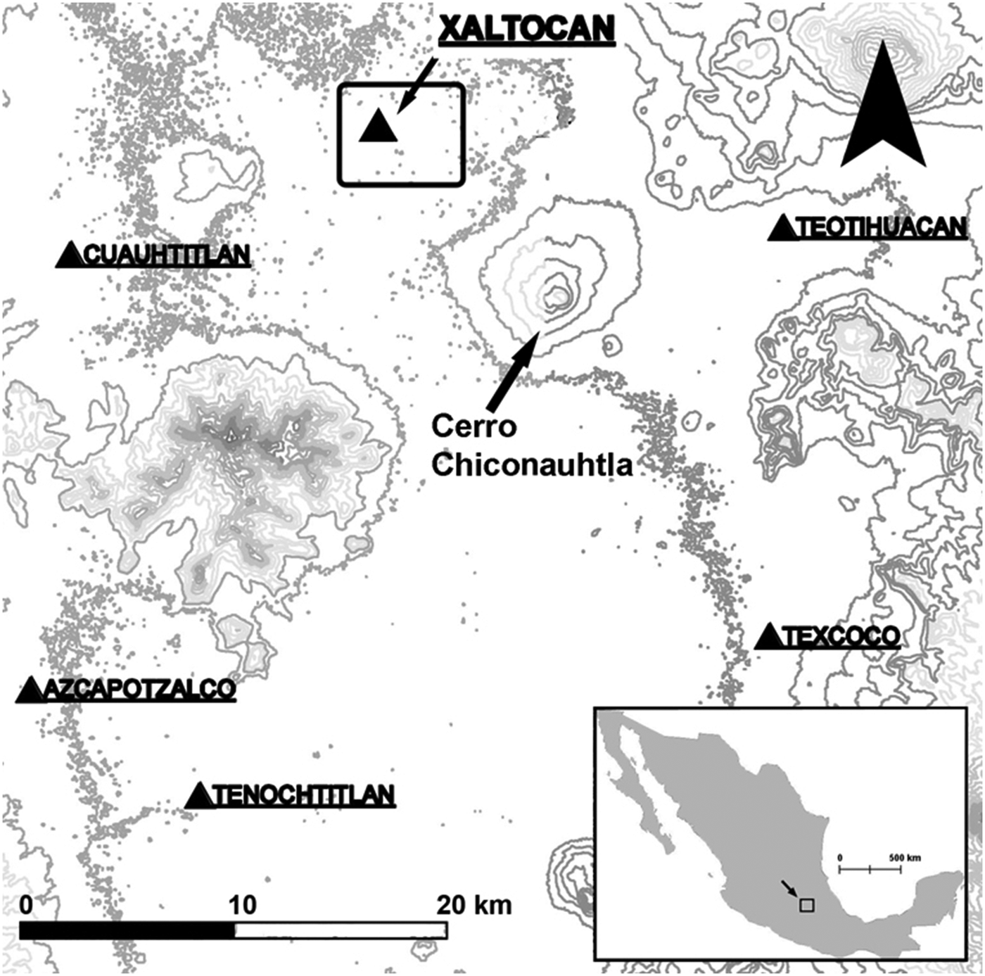
Brumfiel's pioneering publication is 40 years old. But it remains relevant. Archaeologists continue to debate the relationship between agricultural intensification and political power (e.g., Marcus and Stanish Reference Marcus, Stanish, Marcus and Stanish2006; Thurston and Fisher Reference Thurston and Fisher2007). I examine these persisting anthropological issues by presenting an overview of an archaeological study of an agricultural system built around the ancient kingdom of Xaltocan, a site where Brumfiel worked for over 20 years (Brumfiel Reference Brumfiel, Claessen and van de Velde1991a, Reference Brumfiel and Brumfiel2005a). As several contributions to this volume discuss in detail, Xaltocan was a political center founded on an (anthropogenic) island in Lake Xaltocan in the northern Basin of Mexico. It was one of several Middle Postclassic city-states that existed prior to the formation of the Aztec empire in a.d. 1428 (Figure 1). Settlement began by the tenth century a.d., if not earlier. Within two centuries it influenced much of the northern Basin of Mexico (Brumfiel Reference Brumfiel, Claessen and van de Velde1991a; Carrasco Reference Carrasco Pizana1950). Xaltocan's political economy was based on marital alliances, local production, market trade, and tribute (Brumfiel Reference Brumfiel and Brumfiel2005a; De Lucia Reference De Lucia2013; Overholtzer Reference Overholtzer2013). Historical annals describe the polity as the center of the Otomi nation, though it probably grew to be a multi-ethnic community (Brumfiel et al. Reference Brumfiel, Salcedo, Schafer, Hodge and Smith1994). By the mid-fourteenth century Xaltocan was embroiled in warfare with several neighboring ethnic groups and kingdoms, such as the Tepaneca of Azcapotzalco and Cuauhtitlan, the Alcohua of Acolhuacan, and the Mexica of Tenochtitlan (Morehart Reference Morehart2012a). This conflict lasted almost 100 years, but these polities eventually defeated Xaltocan by the end of the fourteenth century. Historic texts state that Xaltocan's population fled and that the community remained abandoned until it was incorporated into the expanding Aztec state during the Late Postclassic (Hicks Reference Hicks, Marcus and Zeitlan1994, Reference Hicks and Brumfiel2005). Every location where historic records state the population fled has a Xaltocan or a Jaltocan today (i.e., Tlaxcala, Hidalgo, Puebla, and Xochimilco) (Morehart and Frederick Reference Morehart and Frederick2014:532). Archaeological data also suggest that some households remained (Miller Reference Miller2007; Overholtzer Reference Overholtzer2013), and the town has been occupied continuously from the Aztec period to today. However, several lines of independent data indicate that Xaltocan's pre-Aztec conquest led to dramatic political, economic, social, and ecological changes. In addition to historical records, systematic changes after Xaltocan's conquest is supported by archaeological evidence of (1) reduced size and wealth in the community; (2) increased economic dependence on Tenochtitlan, the Aztec capital city (Brumfiel Reference Brumfiel and Brumfiel2005a; Hodge and Neff Reference Hodge, Neff and Brumfiel2005; Nichols et al. Reference Nichols, Brumfiel, Neff, Charlton and Glascock2002); (3) a reduction in Otomi ethnic markers in the Late Postclassic (Brumfiel et al. Reference Brumfiel, Salcedo, Schafer, Hodge and Smith1994); (4) genetic discontinuity after conquest (Mata-Míquez et al. Reference Mata-Míguez, Overholtzer, Rodríguez-Alegría, Kemp and Bolnick2012); and (4) the abandonment of the kingdom's agricultural landscape (Morehart Reference Morehart2012b; Morehart and Frederick Reference Morehart and Frederick2014).
Map of Basin of Mexico showing location of Xaltocan in relation to other key sites.

This article examines the role agricultural production played in Xaltocan's political history. Surrounded by a brackish lagoon fed by a series of freshwater springs and influx from the Cuauhtitlan River, Xaltocan existed in a resource rich area (Frederick et al. Reference Frederick, Winsborough, Popper and Brumfiel2005). Its geographical location together with strong ties to the southern Basin of Mexico may have contributed to the growth of the polity when other political centers, such as Tula, were waning in power in the Early Postclassic period. The Middle Postclassic period (ca. a.d. 1200–1350) was the time of Xaltocan's maximum size and power. By this period residents had constructed an expansive and integrated raised field farming system, a form of agriculture locally named chinampas. Articulating the productivity of this landscape with Xaltocan's political economy is the focus of this article. To do so, I estimate the system's output, an exercise that reveals a sizeable caloric surplus. This surplus, I argue, was produced in conjunction with the developing power of the Xaltocan state as farmers adapted their strategies to meet multiple institutional requirements, such as tribute, the market, household needs, and ritual events. Through these overlapping institutional demands producers possibly become integrated into the political economy and, indeed, the body politic as both subjects and active participants.
SURPLUS AND POLITICAL ECONOMY
Quantifying surplus production has a controversial history in anthropology, both theoretically and methodologically (e.g., Barrier Reference Barrier2011; Dalton Reference Dalton1960; Harris Reference Harris1959; Morehart and De Lucia Reference Morehart and De Lucia2015; Orans Reference Orans1966; Pearson Reference Pearson, Polanyi, Arensberg and Pearson1957; Rotstein Reference Rotstein1961; Webster Reference Webster1985). To estimate surplus archaeologists must determine some basic minimum beyond which production can be considered as excess. Theoretically, substantivists in economic anthropology criticized the notion of “absolute surplus” because it failed to recognize the institutional framework within which production occurs (Pearson Reference Pearson, Polanyi, Arensberg and Pearson1957). Dalton argued that a “deliberately contrived surplus (excess) would not make sense. It would be a contradiction in terms because the extra output would be deliberately sought only if it were, so to speak, earmarked prenatally” (Dalton Reference Dalton1960:485). Archaeologists and anthropologists, thus, are forced to rank phenomena as either primary or secondary (i.e., surplus) and, in the process create “a fictional world where the producer has natural rights outside of society” (Rotstein Reference Rotstein1961:562). Instead, substantivists asserted that scholars consider surplus in relative terms. Surplus exists only to the extent that it is recognized as such given a society's cultural and institutional milieu (Pearson Reference Pearson, Polanyi, Arensberg and Pearson1957).
However, estimations of absolute surplus can offer insight into the politics of production and, hence, the institutional mechanisms by which it exists. Orans (Reference Orans1966) argued that despite differing institutional contexts, all groups of people require a basic subsistence, which he labeled sub-minimal surplus (see Harris Reference Harris1959). Brookfield (Reference Brookfield1972) asserted that demographic subsistence requirements set a baseline. Any production beyond this surface constitutes a surplus that can be explained in terms of socially established needs or goals. “Inputs may be wildly uneconomic when measured by caloric returns, yet wholly reasonable when measured against social returns” (Brookfield Reference Brookfield1972:38).
Political models of historical change focus on how surplus production, mobilization, and consumption finance the political economy (e.g., Brumfiel and Earle Reference Brumfiel and Earle1987; D'Altroy and Earle Reference D'Atroy and Earle1985; Earle Reference Earle, Earle and Ericson1977; Hirth Reference Hirth1996). Political models of historical change recognized that production above a household's requirements reflects unequal relations. Childe noted that the “peasant is thereby obliged to exert himself to produce more than he retains himself, for his new ‘masters’” (Childe Reference Childe1951:107). Sahlins (Reference Sahlins1972) argued that any surplus produced above that necessary for household reproduction is a measure of the effect of a social system on an economic system, specifically inequality. Carneiro insisted that “agriculture does not automatically create a food surplus” (Carneiro Reference Carneiro1970:734). Hirth (Reference Hirth1996:226) observed that the “political economy is organized to generate surplus above that required for normal household subsistence purposes.” As Costin and Earle (Reference Costin and Earle1989:692) noted, “control over finance translates into control over the political process.”
Producers’ relationship to the state is multifaceted. Even from the top-down, D'Altroy and Earle (Reference D'Atroy and Earle1985) observed different, overlapping routes by which surplus was appropriated by the state: staple finance and wealth finance. Staple finance involved the payment of foodstuffs as tribute from community or, more often, state lands, which was used to compensate political functionaries. Wealth finance, in contrast, centered on the administration of prestige goods’ production to use as payment for state services and as gifts to promote political alliances.
A dichotomy between absolute and relative surplus is misrepresentative because societies are divisible and comprised of differentially positioned people and institutions. Brumfiel (Reference Brumfiel1992:555) observed that “because the vast majority of production in agrarian societies is household-based, political change almost always involves restructuring of household labor.” This local restructuring occurs not only due to obligations to the state but is also due to multiple institutional demands that households and communities face. Brookfield (Reference Brookfield1972) discussed three kinds of production related to a community's demographic, economic, and social goals: subsistence production, trade production, and social production. Subsistence production is defined at the community or the household level. Trade production involves how agriculturalists produce a surplus to participate in exchange or market systems. Social production conveys how farmers produce a surplus or develop strategies to reproduce the social, political, and economic relationships in their communities. Wolf (Reference Wolf1966) proposed comparable views regarding the social surpluses of peasant economies. Beyond subsistence and the basic surpluses necessary for the reproduction of the means of production, a “replacement fund,” peasants also produce a surplus to participate in the social and religious life of the community, a “ceremonial fund” (Wolf Reference Wolf1966:6–7). They also may have to produce enough to pay tribute or rent to local or regional power holders, a “fund of rent” (Wolf Reference Wolf1966:9–10)—what Sahlins (Reference Sahlins1963:292) labeled a “fund of power.” Sheets (Reference Sheets2000) made a similar observation for the household, community, and state economy at Cerén, El Salvador. Production for inter- and intrahousehold needs produced a horizontal economy within the village. However, by exchanging local goods with centers, village households were able to participate in the regional, vertical economy. Through this relationship, commoners retained a flexible degree of autonomy and strategic control over their productive and exchange decisions.
These works stress the strategies of people to meet multiple institutional demands, many of which are organized differently and reflect heterogeneity and fluidity in society. Different modes of production, that is, co-occur, and people organize their economic behavior according to and are often pulled between the logic and burden of each (Saitta Reference Saitta, Wills and Leonard1994). The demands and costs of market production, for example, can differ physically and subjectively from setting aside goods or scheduling labor to pay tribute or from pooling resources to host a ritual. Even in highly stratified societies, class, kin, and community relations co-exist and condition how surplus is produced, mobilized, and conceived. However, in order to assess these various forms of production, funds, or surpluses from an archaeological (and agricultural) perspective, it is necessary to analytically “cut the Gordian knot of Pearson's substantivist approach to surplus” (Halstead Reference Halstead, Halstead and O'Shea1989:70) and calculate it.
CHINAMPA AGRICULTURE AND POLITICAL ECONOMY
Derived from the Nahuatl word chinamitl, which denotes an area enclosed by canes or hedges (Molina Reference Molina1944:21), the term chinampa describes highly productive wetland agriculture in the Basin of Mexico in which long, narrow fields were built above water and separated by canals (e.g., Armillas Reference Armillas1971; Avila López Reference Avila López1991; Coe Reference Coe1964; Crossley Reference Crossley1999; Frederick Reference Frederick, Thurston and Fisher2007; Gomez Pompa and Jiménez Osornio Reference Gomez Pompa, Osornio, Truman and Gladwin1989; Morehart Reference Morehart2009, Reference Morehart2010, Reference Morehart2012b; Nichols and Frederick Reference Nichols, Frederick, Scarborough and Isaac1993; Palerm Reference Palerm1973; Parsons Reference Parsons and Cleland1976; Parsons et al. Reference Parsons, Parsons, Popper, Taft and Farrington1985; Rojas Rabiela Reference Rojas Rabiela and Harvey1991; Sanders Reference Sanders1957; Santamaría Reference Santamaría1912; West and Armillas Reference West and Armillas1950). As such, chinampas are a form of raised field agriculture common throughout the New World (see Morehart and Frederick Reference Morehart and Frederick2014:532). Although incredible diversity existed in this technology during the Postclassic and Colonial periods in the basin (Avila López Reference Avila López1991; Calnek Reference Calnek1972; Frederick Reference Frederick, Thurston and Fisher2007), chinampas have generated much discussion on agricultural production and political development. After the Aztec Triple Alliance formed (ca. a.d. 1428), the conquest of southern basin city-states, such as Xochmilco, was one of the first strategies of imperial expansion (Berdan and Anawalt Reference Berdan and Patricia R1992:19). Prior to this time, farmers maintained small-scale chinampas adjacent to their households and communities in the freshwater lakes of Xochimilco and Chalco (Luna Reference Luna Golya2014; Parsons Reference Parsons and Cleland1976:241; Parsons et al. Reference Parsons, Brumfiel and Wilson1982:229–230). Chinampa farming expanded and intensified following incorporation into the Aztec state, eventually covering over 12,000 km2 (Armillas Reference Armillas1971:660). Given the highly standardized nature of this landscape, Armillas argued that its organization was the product of state hydrological engineering, a widespread infrastructural strategy of the Aztec empire in the Basin of Mexico (Palerm Reference Palerm1973; Rojas Rabiela Reference Rojas Rabiela1974; Sanders and Price Reference Sanders and Price1968).
Information on Aztec political demands on chinampa farmers is sketchy. A letter written in 1544 to Carlos, King of Spain, by encomendero Jerónimo López describes that during the time of Mocteczuma “all the towns and provinces of his kingdom were forced to plant and there were overseers in his time to see if they were planted” (Paso y Troncoso Reference Paso y Troncoso1939:169). However, records on tribute paid at the imperial level and the provincial level in non-chinampa areas suggest farmers had relatively light tributary burdens (Morehart and Eisenberg Reference Morehart and Eisenberg2010:96; Offner Reference Offner1981). The role of other tribute items, such as prestige goods, and the effect of an integrated market system created a complex economic mosaic that cannot be characterized via single models of commodity production and flow (Berdan et al. Reference Berdan, Berdan, Blanton, Boone, Hodge, Smith and Umberger1996; Brumfiel Reference Brumfiel, Brumfiel and Earle1987; Smith Reference Smith, Smith and Berdan2003), such as Wolf's (Reference Wolf1982) notion of a tributary mode of production. That said, the Codex Mendoza records that Chalco, located in the heart of the chinampa lakes zone, paid higher taxes in maize to the Aztec state than other subject towns (Morehart and Eisenberg Reference Morehart and Eisenberg2010:95), reflecting regional diversity in state demands over local production.
The role of the Aztec state was multifaceted. Chinampa production articulated with multiple local and non-local institutions. Parsons (Reference Parsons and Cleland1976, Reference Parsons and Harvey1991) noted that chinampa produce met various institutional demands. Farmers produced enough for their households. Members of local communities paid produce to their indigenous lords or calpolli leaders, who had to pay imperial taxes and finance their own political ambitions. Non-calpolli, tenant farmers working lands owned by imperial nobles, however, paid rent. Many agricultural items flowed directly to the market at Tenochtitlan (Parsons Reference Parsons and Cleland1976). Meeting the needs of these local and non-local political economies may have increased the burden on farmers. However, Brumfiel (Reference Brumfiel and Harvey1991b) found chinamperos maintained a high degree of economic autonomy and flexibility, suggesting little direct control. Chinampa farming offered a means to support local and urban populations and also offered an imperial strategy to indirectly shape the lives of subjects by manipulating the flow of goods and the distribution of land.
CHINAMPA SURPLUS AT XALTOCAN
Methodologically, calculating agricultural surplus is similar to catchment analysis (e.g., Brumfiel Reference Brumfiel and Flannery1976; Earle Reference Earle1978; Evans Reference Evans1990; Feinman Reference Feinman and Earle1991; Flannery Reference Flannery and Flannery1976; Hirth 1984; Kolata Reference Kolata1991; Morehart Reference Morehart2010; Parsons Reference Parsons and Cleland1976; Steponaitis Reference Steponaitis1981; Wilkinson Reference Wilkinson1994; Whitmore and Williams Reference Whitmore and Williams1998; Zarky Reference Zarky and Flannery1976). It requires several simplifying assumptions and estimations regarding population size, dietary requirements, climatological conditions, land-use chronology, and land productivity. Unless more detailed social, demographic, edaphic, climatological, and property data are known, such as in Whitmore and William's (Reference Whitmore and Williams1998) study, these variables are open to criticism. However, when limitations in parameters are understood and made explicit, productivity and surplus estimates offer informative and interpretively useful data. Here I present an analysis estimating the productivity of Xaltocan's chinampa system. I offer data descriptions and methods for each step I employ, which involves estimates of spatial characteristics, chronology, population, dietary and labor requirements, types of crops cultivated, and productive potential.
1,000 ha of Arable Land: Spatial Characteristics
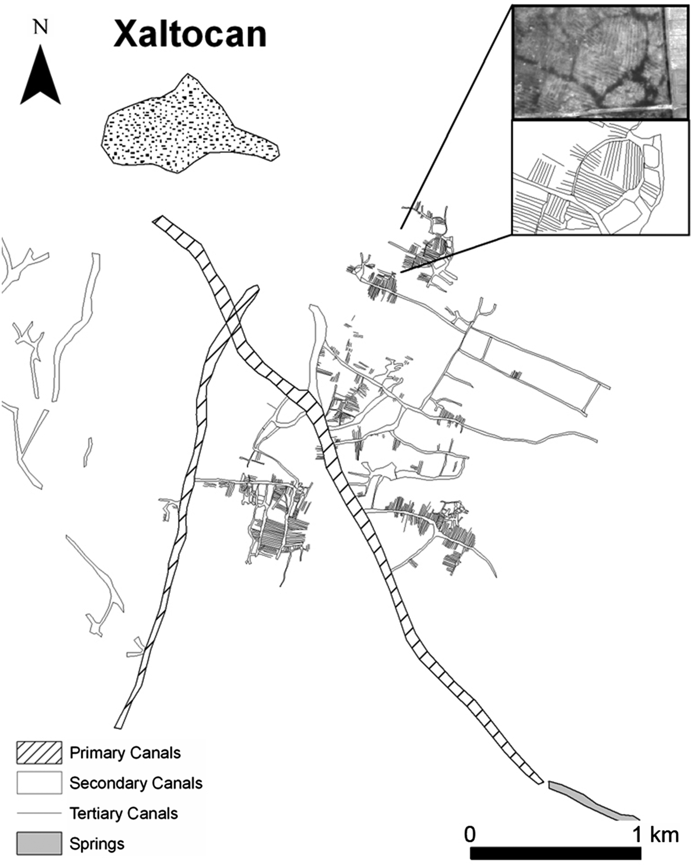
Xaltocan's farming landscape consisted of a system of chinampas in the surrounding lake. Lake Xaltocan is now drained and the chinampas are buried, making them virtually invisible on the surface. Nevertheless, building on the earlier research of Charles Frederick (Frederick Reference Frederick, Thurston and Fisher2007; Frederick et al. Reference Frederick, Winsborough, Popper and Brumfiel2005; Nichols and Frederick Reference Nichols, Frederick, Scarborough and Isaac1993), I mapped it using aerial photos and satellite imagery in ArcGIS (Morehart Reference Morehart2009, Reference Morehart2010, Reference Morehart2012b; Morehart and Frederick Reference Morehart and Frederick2014) (Figures 2 and 3).
GIS map of Xaltocan's chinampa system made using Very High Resolution Quickbird satellite data. Tonanitla is shown in Figure 3.
The chinampa system consisted of a network of fields and canals covering between 1,500 and 2,000 hectares (Morehart Reference Morehart2012b). I classified canals into a three type hierarchy reflecting their hydrological role. The two primary canals were the largest and most central arteries. One, approximately 3 km long, connected Xaltocan to the community of Tonanitla to the south. Tonanitla may have been one of Xaltocan's tributaries (Morehart Reference Morehart2012a). This canal likely also served as a transportation route. The other primary canal, between 5 and 6 km long, transported freshwater from springs at the foot of Cerro Chiconautla, a key integrating resource. Both canals were straight and wide, between 50 and 60 m, the only features still partially visible on the surface today. The springs were drained to provide water for Mexico City several decades ago (Morehart Reference Morehart2013), and it was not possible to measure the volume of output. Secondary canals typically emerged from the sides of the primary ones and transported water to the core of the system. Tertiary canals existed as off-shoots of both primary and, more commonly, secondary canals. These canals were about 1 m wide but many meters long. They separated individual fields and were the most immediate source of water for farmers, giving the system its characteristic chinampa appearance (Figures 2 and 3).
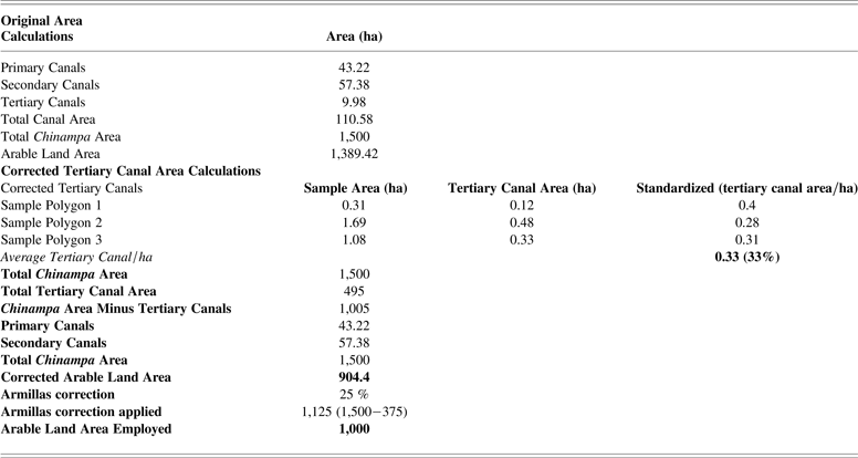
The system may have been much larger than the 1,500 to 2,000 ha estimate given the nature of remote sensing data (Morehart Reference Morehart2012b). Thus, 1,500 ha is a conservative figure. However, the area of canals must be subtracted from this estimate to obtain a figure of arable land, which I calculated using ArcGIS with stratigraphic data on field and canal sizes (Morehart Reference Morehart2010:193) (Table 1). This procedure was relatively simple for secondary and primary canals because they were mapped as polygon features. The total area encompassed by the two primary canals is 43.22 ha. The area of secondary canals consists of 57.38 ha. This procedure was more difficult for tertiary canals because they were mapped as vector lines, features with no width. To estimate the area encompassed by tertiary canals, I approximated their general width as 2 m. This figure is within the range documented by excavations and conforms to width measurements made using satellite data. This figure was multiplied by the length of each canal feature. The result is the approximate areas for each tertiary canal in square meters, which I converted into hectares. The total area for the mapped tertiary canals was 9.98 ha. Using these figures, the total canal area was 110.58 ha, leaving 1389.42 ha of arable land.
Area calculations for Xaltocan's chinampa system.
This figure is problematic. Although the area of primary canals is reliable, it was not possible to accurately map all tertiary canals given the incomplete visibility in satellite data. Their areas likely are underrepresented. To solve this problem, I selected three sample areas in ArcGIS by creating polygon features in places with high densities of mapped tertiary canals. One sample area was 0.31 ha, another 1.69 ha, and the final sample was 1.08 ha (Table 1). I used ArcGIS's clip tool to extract canal features falling within each polygon. The area of tertiary canals within each sample was then recalculated as ArcGIS does not automatically adjust the new distance and area values in the attribute table. I then standardized the tertiary canal areas in each sample by the area of the sample polygon to accommodate for their size differences and to produce a per hectare figure for each sample polygon. Finally, the three values were averaged. This final figure, 0.33 ha, represents an approximate area for tertiary canals per hectare. In other words, when extrapolated beyond the sample areas, this technique suggests that around one-third, or 495 ha, of the overall area was tertiary canals. The larger overall area of tertiary canals compared to primary and secondary canals makes sense due to their hydrological position separating individual fields (a tree-like hydrological structure with tertiary canals being the more numerous branches). When subtracted from the overall size estimate, this procedure leaves 1,005 ha of arable land. Of course, some of this area also was encompassed by the primary and secondary canals, which have a combined area of 100.6 ha. Thus, when this additional figure is subtracted, basically 900 ha of arable land are left.
This technique, while innovative, might inflate the overall area of canals, though it helps put the estimations in an appropriate range. Armillas (Reference Armillas1971:660) reduced the 12,000 ha estimate for the southern basin chinampa zone by 25 percent to accommodate for canals, leaving 9,000 ha of arable land (Parsons [Reference Parsons and Cleland1976:245] changed this figure to 9,500 ha). Armillas did not specify the specific reasons behind this percentage, but I suspect it was an informed, subjective assessment. In comparison with the methodology just employed, which gave a 33 percent figure, he was not far off. Subtracting 25 percent from Xaltocan's total chinampa area results in 1,125 ha of arable land (Table 1). Given limitations in the available data, I employ a figure of 1,000 ha of arable land for Xaltocan's chinampa system. This value is more conservative than Armillas’, though higher than the 900 ha figure. On the other hand, given that 1,500 ha overall is itself a conservative estimate, I am satisfied that 1,000 ha is an acceptable figure.
Middle Postclassic Maximum: Chinampa Chronology
These size estimates would be misleading if the chinampa system was not in use at the same time. Xaltocan's chinampas had a complex, complicated layout that could suggest an accretionary pattern of growth unlike the systematic standardization of the later Aztec system (Figures 2 and 3) (Armillas Reference Armillas1971; Frederick Reference Frederick, Thurston and Fisher2007; see also Doolittle Reference Doolittle1984 and Woodbury Reference Woodbury1961). Agricultural systems are notoriously difficult to date directly. However, two lines of data overwhelmingly suggest that it was in use at the same time, at least during the height of Xaltocan's Middle Postclassic power.
Ceramic data were obtained from excavations and from over 1,000 systematic surface survey collections (Morehart and Frederick Reference Morehart and Frederick2014). An examination of the distribution of Black on Orange pottery types, perhaps the most temporally sensitive artifacts of Postclassic central Mexico, reveals an interesting chronology. Aztec I and II pottery are dominant both in terms of their percentage (Az I: 23 percent; Az II: 57 percent) and in terms of their ubiquity (Az I: 31 percent; Az II: 65 percent;). These pottery types date to the Early and Middle Postclassic, during Xaltocan's development and apogee. Aztec III and IV pottery are rare (Percentage: Az III: 5 percent; Az IV: 1 percent; Ubiquity: Az III: 7 percent; Az IV: 2 percent). These types date to the later Aztec empire and early colonial periods after Xaltocan's conquest. The higher ubiquity values of Middle Postclassic ceramics also reflect their greater spatial distribution across the field system, suggesting more widespread, intensive use during this time. Ceramic data from excavations mirror the results from the survey. Again, the distribution of Black on Orange pottery shows an overwhelming pattern. Seventy-eight percent is Aztec II and 18 percent is Aztec I. Few Aztec III or IV sherds were found.
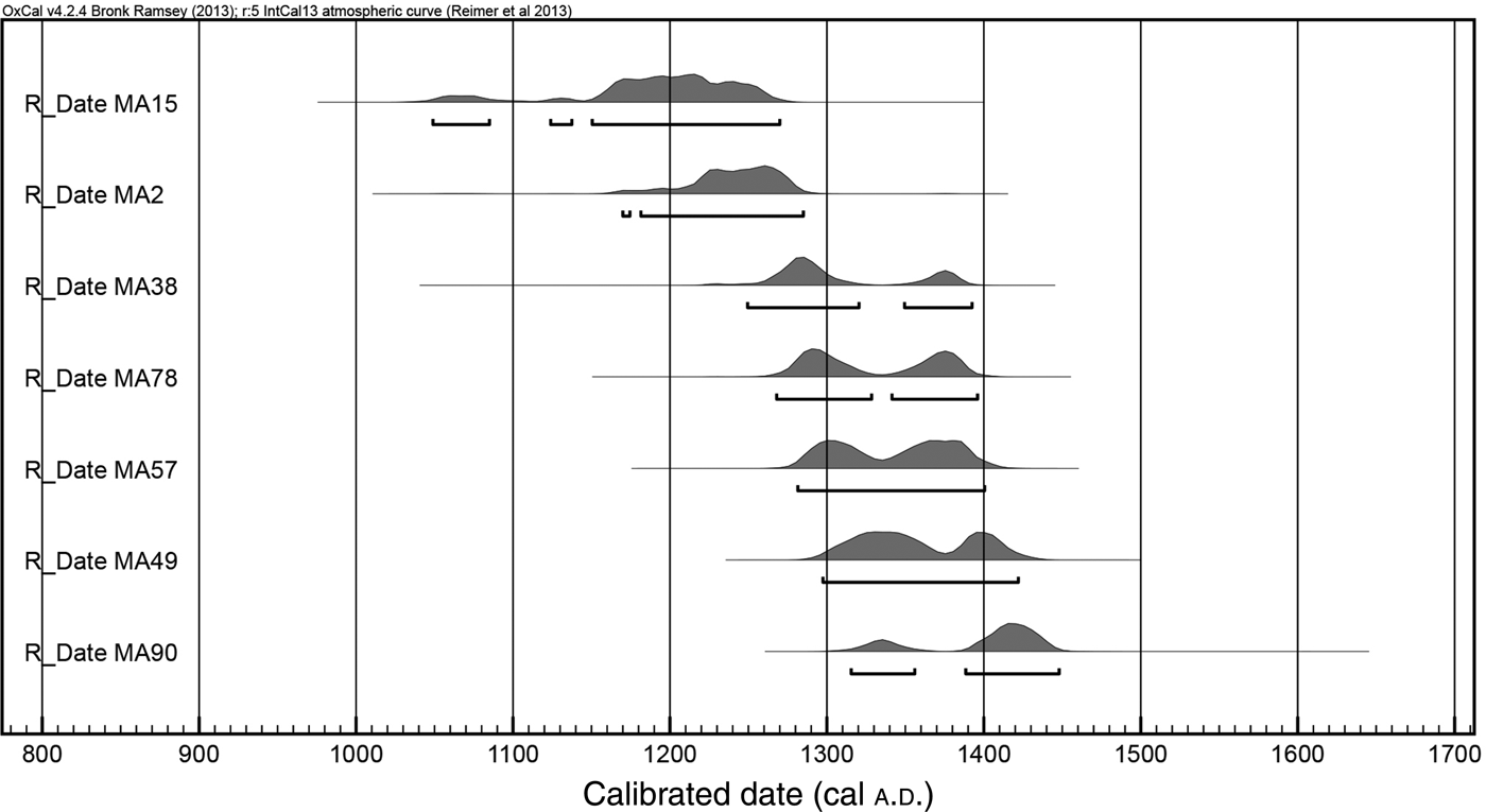
AMS dates on pine charcoal and maize cobs from excavations support this chronology. Although they suggest chinampa farming began when Xaltocan was first emerging as a political center during the Early Postclassic, they date prior to Xaltocan's mid-fifteenth century incorporation into the Aztec empire (Figure 4). Two dates are very early and could be anomalous or redeposited (see Morehart and Frederick Reference Morehart and Frederick2014). Most cluster from the Middle Postclassic to the early Late Postclassic, during the polity's apogee and before the area's incorporation into the Aztec Empire. Together with the ceramics, these dates support the conclusion that chinampa production was at its maximum intensity during Xaltocan's major period of influence and power. The possibility that some lands were in fallow at different periods of time exists. Ethnographic data indicate that fallowing is infrequent and is for very short periods of time when it does occur (Sanders Reference Sanders1957:91). Given the intrinsic productivity and renewable fertility of chinampa soils (Morehart Reference Morehart2010:122) and possible influences stemming from increased political economic requirements during the Middle Postclassic, I maintain full system production in my calculations of surplus below.
AMS date ranges (2 sigma calibration) for samples recovered during excavations of Xaltocan's chinampas. MA2, MA57, MA78, and MA90 were from carbonized maize (Zea mays) cobs recovered from deposits of water laid sediment in canal cuts; MA49 was from a maize cob recovered at the base of a canal cut; MA38 was from a maize cob recovered at the edge of a canal cut, where the canal joined a field surface; MA15 was a sample of pine (Pinus sp.) charcoal recovered from an artificially constructed area built up under a field surface.
5,000: Population Reconstruction
Archaeologists do not know the size of Xaltocan's pre-Hispanic population. The first archaeological population estimate of Xaltocan follows from the Basin of Mexico regional survey directed by Parsons (see Parsons Reference Parsons2008; Parsons et al. Reference Parsons, Kintigh and Gregg1983; Sanders et al. Reference Sanders, Parsons and Santley1979). Sites were classified for each major occupation based on their size and the density of artifact remains, as well as the presence and type of standing architecture. Xaltocan was classified a local center of 68 ha. To be conservative, low and high ranges were provided. Surveyors estimated Xaltocan's population between 1,750, at the lowest, and 3,400, at the highest.
Subsequent research at Xaltocan revealed greater time depth than the survey's original estimate and indicated its influence was more regional than local (Brumfiel Reference Brumfiel and Brumfiel2005a). But the population reconstruction remains unclear. Brumfiel (Reference Brumfiel and Brumfiel2005a:349) offers a maximum population of 4,200 for the first settlement phase (Phase 1) but not for subsequent phases. Chimonas (Reference Chimonas and Brumfiel2005) examined changes in population over time but only proportionally (based on ceramic densities) without absolute population estimates. In Sanders et al.'s (Reference Sanders, Parsons and Santley1979:151) synthesis of the Basin of Mexico surveys, Xaltocan is included in a general statement about small centers with populations up to 5,000. I feel it this figure is more acceptable than the other twoFootnote 1. In fact, it might itself be too low. Up to the Late Postclassic period, Xaltocan was a key, regional center until it was conquered. Its major Tepaneca and Alcohua competitors, however, had populations between 10,000 and 25,000 (Sanders et al. Reference Sanders, Parsons and Santley1979:151; Smith Reference Smith2008:39). Xaltocan's island condition likely did not limit population growth and density entirely. Tenochtitlan after all was an island city with a population that reached over 100,000 (see Rojas Reference Rojas2012:50–52). Finally, if we re-examine the original survey methodology, Xaltocan's low and high population ranges were calculated using figures for moderate density occupation, 25–50 persons per ha (Parsons et al. Reference Parsons, Kintigh and Gregg1983; Sanders et al. Reference Sanders, Parsons and Santley1979:39). If we instead employ the low and high ranges for a moderate-to-heavy or heavy occupation, which is 50–100 persons per ha, the low and high ranges for Xaltocan become 3,400, at the lowest, and 6,800, at the highest. Thus, a 5,000 estimate is within the population ranges available using the Basin of Mexico regional survey methodology. It also increases the population to make it more realistically comparable to other centers while retaining the conservatism that Sanders et al. (Reference Sanders, Parsons and Santley1979:151) urged.
1,000,000 kg of Maize a Year: Dietary Requirements and Crop Types
Various caloric estimates exist in the literature to gauge biological, sub-minimal requirements. Most analyses employ maize in kg or kcal to pinpoint caloric needs (e.g., Cook and Borah Reference Cook and Borah1979; Feinman Reference Feinman and Earle1991; Kowalewski Reference Kowalewski, Blanton, Kowalewski, Feinman and Appel1982; Parsons Reference Parsons and Cleland1976; Sanders Reference Sanders1957; Santley and Rose Reference Santley and Rose1979; Whitmore and Williams Reference Whitmore and Williams1998; Williams Reference Williams1989). I follow others in employing maize, but this decision requires justification. Ethnographically, the range of crops that chinampa farmers cultivate includes a mosaic of plants beyond maize (Sanders Reference Sanders1957; Santamaría Reference Santamaría1912). Archaeobotanical research of chinampa agriculture in the southern basin supports this assessment (Avila López Reference Avila López1991, Reference Avila López2006; Parsons et al. Reference Parsons, Parsons, Popper, Taft and Farrington1985; Popper Reference Popper1995). Historic texts indicate that Xaltocan's chinampa farmers also followed this practice (Tezozómoc Reference Tezozómoc1975:38). Archaeobotanical data from Xaltocan's chinampas suggest that maize was not the only crop (Frederick et al. Reference Frederick, Winsborough, Popper and Brumfiel2005; McClung de Tapia and Martínez Yrizar Reference McClung de Tapia, Yrizar and Brumfiel2005; Morehart Reference Morehart2010:262). Yet maize was clearly dominant when considering both macrofloral and microfloral remains from both the community and the fields (Brumfiel Reference Brumfiel and Brumfiel2005a:353; Morehart Reference Morehart2010:258). In fact, the reliance on maize from the chinampas may have increased as the polity developed and became embroiled in war (Morehart and Eisenberg Reference Morehart and Eisenberg2010; see below). Thus, while problematic, an empirical basis exists for this simplifying assumption (see Hunt [Reference Hunt2000:266] for an analytical justification for centering on one crop).
The next step is to multiply individual caloric needs by the estimated population. Whitmore and Williams (Reference Whitmore and Williams1998:86–87) specify a range between 850 to 2,475 kcal a day depending on the individuals age, sex, and life cycle, equaling 310,250 and 903,375 kcal/year, respectively. They further calculate 3,500 kcal from one kg of maize. In other words, between 88.64 kg and 258.10 of maize would be necessary to support their ranges. Kowalewski (Reference Kowalewski, Blanton, Kowalewski, Feinman and Appel1982:158; see also Nichols Reference Nichols1987:606) suggests maize consumption between 160 and 290 kg per person per year. In a study specifically on twentieth century chinampa farming in the southern Basin of Mexico, Sanders (cited in Parsons Reference Parsons and Cleland1976:242–243) estimated that an individual requires at least 160 kg of maize per year, which serves as his per capita subsistence baseline. Parsons (Reference Parsons and Cleland1976:243) recognized the need for other nutritional components not provided by maize. Thus, he increased Sanders’ value to 200 kg of maize per year to accommodate these additional requirements. I employ this figure. Because it lies at neither extreme of other investigators’ estimations it offers a possible median value of aggregate caloric requirements to characterize the community as a whole. Using these figures, an estimated population of 5,000 at Xaltocan would require 1,000,000 kg of maize each year.
3,000,000 kg of Maize a Year: Productivity and Labor Requirements
Next, the estimated productivity of Xaltocan's chinampa system must be established. Sanders (Reference Sanders1957:83–85) concluded that chinampas in the southern Basin of Mexico can produce between 3,000 and 4,000 kg of maize grain per year per hectare (see also Santamaría Reference Santamaría1912), and I rely on the more conservative estimate. In Sanders’ case, he was estimating productivity for at least two maize harvests a year. The application of this productivity estimate to Xaltocan's system requires discussion given that the northern Basin of Mexico differs from the south in terms of annual precipitation, water quality, and temperature. Although Lake Xaltocan is often considered a saline lake, its salinity was connected to anthropogenic processes from the Late Postclassic to the Colonial periods (Morehart Reference Morehart2010). Salinity was not an obstacle to agricultural production during Xaltocan's independence. Based on soil chemistry and microfloral analyses, the influx of freshwater sources appear to have created an environment hydrologically similar to the southern lakes (Frederick et al. Reference Frederick, Winsborough, Popper and Brumfiel2005:107; Morehart Reference Morehart2010:199). Nichols (Reference Nichols1987:601), writing on agriculture in the northern basin, observed differences in yield depending on the hydrological nature of farming and the topographic location of farms. Rain-based systems are significantly less productive than systems based on either floodwater or permanent irrigation. Permanent irrigation systems along the lakeshore of Texcoco, a saline lake, had maximum ranges exceeding the 3,000 figure. Similar data provided by Charlton (Reference Charlton, Sanders, Kovar, Charlton and Diehl1970:288) support Nichols’ work. Given the circumstances of her research she was not able to consider chinampa systems. Sanders, however, observed that the “chinampa” system near Teotihuacan was capable of “probably the highest maize yields in the Teotihuacan Valley” (Sanders Reference Sanders1965:45; see also Charlton Reference Charlton, Sanders, Kovar, Charlton and Diehl1970:271). Given the high productivity of chinampa farming 3,000 kg/ha/year is an acceptable figure.
This estimate and the agricultural cycle can be considered in light of data from Xaltocan and nearby areas. Today at Xaltocan, ejido parcels are irrigated, and there are generally two treatments each year. Most of these are in preparation for the planting season. One occurs between December and January, and another occurs between March and April and sometimes into May. Ejido farmers have two annual crops, maize and barley, though some plant nopal cacti (Opuntia sp.). Maize is planted from May to June and harvested between August and September. Barley is harvested around November and December, between one to two months before the first annual irrigation treatment. If farmers can afford it, a third treatment of water sometimes is applied between the maize and barley cycles. Parcels are between 1 and 1.5 ha, and most farmers own between one and three. The typical pattern is three, usually two measuring 1.5 ha and another measuring 1 ha. Significantly, parcels are not fallowed. All parcels owned by a family are cultivated simultaneously year after year, though farmers might shift between the two primary crops. In terms of maize yield, farmers with whom I spoke gave varying figures. Several respondents, however, said that 1 ha can produce as much as 5,000 kg of maize. This high yield is due to irrigation. Also, some farmers hinted at the application of chemical fertilizers (i.e., phosphorus and nitrate), which also could explain these high figures. Prior to these practices, farmers estimated that the annual yield of grains was less, between 2,000 and 3,000 kg.
Historic documents provide some support for the agricultural cycles for this area. The Suma de Visitas, written in the mid-sixteenth century, records that Nextlalpan, located just to the north, had two harvests a year for both wheat and maize (Paso y Troncoso Reference Paso y Troncoso1905:166). One harvest was on irrigated land and the other on dry land. For wheat, residents produced 34 fanegas a year from irrigated parcels and 150 from dry land. For maize, they produced 213 fanegas, but the document does not distinguish between irrigated and dry land yields. A fanega represented around 1.5 bushels of maize, which can be converted to between 35 and 38 kg of dried maize (Gibson Reference Gibson1964:309; Offner Reference Offner1981:51; Williams Reference Williams1989:718). Thus, in terms of maize, either 7,455 or 8,094 kg were produced. This document, however, does not specify the area of land under cultivation. Moreover, this is an absolute tribute assessment “all of which went to Mexico” (Paso y Troncoso Reference Paso y Troncoso1905:166). Thus, the additional yield used for subsistence and local surplus is not recorded. The vague population figures in this record indicate that annual tribute was only a fraction of the amount necessary for local needs. Nevertheless, this information reinforces the possibility of multiple yearly harvests of maize in Xaltocan's chinampa system.
Using this 3,000 kg/ha figure to estimate the productivity of Xaltocan's chinampas results in 3,000,000 kg of maize per year (3,000 kg x 1,000 ha). If this amount is calculated on a per capita level based on the 200 kg/person/year figure presented above then Xaltocan's chinampa system could have supported 15,000 individuals, 10,000 more individuals than the 5,000 figure, a sizeable surplus. Stated differently, a population of 5,000 would require approximately 33 percent of the total yield, leaving 67 percent, or 2,000,000 kg, as surplus.
The productivity of the chinampa system can be related to the labor capacity and subsistence requirements of agriculturalists themselves. Parsons (Reference Parsons and Cleland1976:246) calculated that a single farmer can cultivate only about 0.75 ha of chinampa land a year given the intensity of chinampa agriculture. When applied to the Xaltocan case, about 1,333.33 individuals would have been necessary to maintain the chinampa system at its maximum productivity. In terms of Xaltocan's population of 5,000, thus, 27 percent could have been necessary farmers. Considering the system's overall productivity, each farmer's per capita labor constitutes 9 percent of the total amount required to achieve maximum yields (i.e., to produce enough to support 15,000 people). Moreover, 1,333.33 cultivators would have required 266,666.67 kg of maize a year. This would leave a per capita surplus of 2,050 kg and a total surplus of 2,733,333.33 kg for the system as a whole. In other words, when farmer's subsistence needs are subtracted, as much as 91 percent of the total product of the chinampa system constituted a surplus from a primary producer standpoint. This value is significantly greater than the 67 percent figure that does not distinguish the work and biological needs of farmers from other consumers in the population.
SURPLUS AND INSTITUTIONAL INTEGRATION
The Spanish friar Bernardino de Sahagún wrote that the good farmer is “bound to the soil” (Sahagún Reference Sahagún, Anderson and Dibble1961:41). This situation seems more than metaphorical for chinampa farmers. Chinampas are able to continually absorb labor in progressively more microscalar ways, a process Clifford Geertz (Reference Geertz1963) called agricultural involution. With greater intensification and capital input, farmers become socially, economically, and politically tethered to their investments, which can increase agriculturalists’ susceptibility to control by those seeking to finance a political economy (e.g., Earle Reference Earle1997; Erickson Reference Erickson, Scarborough and Isaac1993; Gilman Reference Gilman1981). This interpretation elucidates the surplus produced in Xaltocan's chinampas. Production was greater than the town's maximum population requirements. Surplus production was connected to meeting the demands of the Xaltocan state. Chinampa farmers likely paid a set amount of their produce to finance political institutions, especially local nobility (Morehart and Eisenberg Reference Morehart and Eisenberg2010). Xaltocan's rulers possibly also drew on the surplus to pay non-agricultural officials (cf. Berdan Reference Berdan1975; Brumfiel Reference Brumfiel1980; Calnek Reference Calnek, Hardoy and Schaedel1975). They also probably mobilized the flow of surplus to host events that fostered local and extra-local alliances.
These practices could reinforce and cross-cut ethnic divisions (Brumfiel Reference Brumfiel, Brumfiel and Fox1994). For instance, Xaltocan maintained strong alliances with Nahua kingdoms in central Mexico as the polity developed, especially in the southern Basin (Brumfiel Reference Brumfiel and Brumfiel2005a). Carrasco (Reference Carrasco Pizana1950:137–138) argued that Xaltocan and the Otomi center of Metztitlan participated in a cult of the moon goddess and worshipped Otonteuctli, deity of fire and death (see also Sahagún Reference Sahagún1997). Tzompantzin, Xaltocan's last ruler, was born in Metztitlan (Alva Ixtlilxochitl Reference Alva Ixtlilxochitl and Chavero1891, 1:137). Mobilizing surplus for rituals could have promoted both political and ethnic ties across wide regions, particularly as Tzompantzin's regime engaged in warfare during the fourteenth century. In fact, Tzompantzin and his followers possibly fled to Metztitlan when Xaltocan was conquered, a haven likely made possible by his continued connections.
War possibly increased the burden on farmers as increased food was needed to support warriors and to maintain distant alliances (Morehart and Eisenberg Reference Morehart and Eisenberg2010). The development of chinampa agriculture during the Middle Postclassic may have been partly the result of political circumscription. The Anales de Cuauhtitlan records that residents of Xaltocan risked attack if they wandered too far from town (Bierhorst Reference Bierhorst1992:57). The rough dietary estimates also do not consider the additional energy requirements of warriors engaged in sporadic battles or prolonged conflict (e.g., Rappaport Reference Rappaport1968).
Other institutional spheres, dominated by different relationships and practices but essential to social life, also required financing: ceremonial events, market exchange, and the reproduction of the household and field (e.g., Brookfield Reference Brookfield1972; Monaghan Reference Monaghan1995; Morehart Reference Morehart2010; Sheets Reference Sheets2000; Spielman Reference Spielman2002; Wells Reference Wells2006; Wolf Reference Wolf1966). These overlapping demands can cause a degree of heterogeneity in production. Genetic and ecological factors created a diverse landscape of central Mexican maize (Benz Reference Benz1986). Farmers often cultivated several types to meet the requirements of dissimilar institutional spheres. Different maize varieties and different parts of the maize plants, especially stalks and tassels, were necessary (Sahagún Reference Sahagún, Anderson and Dibble1963:279–280). Deities had different preferences, and feasts called for specific kinds of maize. Maize was offered to gods as ears and in processed states (Durán Reference Durán, Horcasitas and Heyden1971; Ruiz de Alarcón Reference Ruiz de Alarcón1984; Sahagún Reference Sahagún, Anderson and Dibble1951). Local production could be augmented via the market, allowing people to acquire produce to meet variable institutional domains of consumption (Sahagún Reference Sahagún, Anderson and Dibble1961:65–71).
If residents were producing or acquiring agricultural products to maintain many different kinds of institutions, we should expect to see this strategy reflected in the diversity of crops. In a previous study on maize from the community and the chinampas, Morehart and Eisenberg (Reference Morehart and Eisenberg2010) documented temporal shifts in diversity. Maize diversity from the chinampas was relatively low, and diversity in the community was lowest as Xaltocan attained its maximum political power (during Phases 2 and 3) (Figure 5). In fact, the range of variation in chinampa maize and in community maize from Phase 3 deposits occupies the same dimensional space, suggesting that residents consumed chinampa maize almost exclusively during the kingdom's height.
Representation of changing maize diversity at Xaltocan in relation to chinampa maize. Diversity value (H’) based on the Shannon Diversity Index (see Morehart and Eisenberg Reference Morehart and Eisenberg2010).
Despite its reduced diversity, maize consumption increased. Brumfiel (Reference Brumfiel and Brumfiel2005a:353) calculated a significant increase in maize ubiquity in the town (from 45 to 68 percent) as Xaltocan developed in political power. As maize diversity decreased, the overall diversity of crops in the community also diminished (Morehart Reference Morehart2010:300). These patterns suggest the progressive standardization of and dependence on maize when consumption was highest and the increasing reliance on local chinampas, rather than the market, especially as the community became enmeshed in warfare.
The standardization of and increasing reliance on maize at Xaltocan might suggest transformations in the institutional structures of production, consumption, and exchange. The reduced diversity indicates that farmers became reliant on similar kinds of maize both to pay tribute and to meet the institutions necessary for social reproduction and everyday life. I do not suggest direct state control over non-state institutions. Instead, this change may have stemmed from the overlapping nature of social, economic, and political institutions. Institutional overlap could become progressively isomorphic, leading to highly politicized relationships, patterns of behavior, and institutional integration.
Other data from Xaltocan support this observation, which suggest a political transformation in the institutions necessary for social reproduction. For example, in a separate study of Middle Postclassic pottery from Xaltocan, Brumfiel argued that the iconography of vessels associated with community and feasting depict motifs associated with the sun, sacrifice, and cosmic warfare. She argued Xaltocan's persistent conflict may have helped to engender an ideology that supported and legitimized war (Brumfiel Reference Brumfiel, DeMarrais, Gosden and Renfrew2005b:234). Overholtzer (Reference Overholtzer2009) documented an increase in the frequencies of warrior figurines from households during the late Middle Postclassic when Xaltocan had already been embroiled in regional conflict for several decades (Figure 6), suggesting the reproduction of this ideology within the domestic sphere. When combined with the homogeneity in maize, these data might suggest increased participation, economically and ideologically, in warfare stemming from the integration of institutions necessary for the household, the community, and the state.
Eroded Postclassic warrior figurine from Xaltocan's chinampa system. Scale increments in cm.
A level of dependency possibly resulted as local residents adapted their strategies and social relationships to participate in the body politic. The way in which surplus production and flow met overlapping institutional requirements likely contributed to this process. When Xaltocan was conquered, the integration of institutions fractured and patterns of land use became unsustainable (Morehart Reference Morehart2010). With a collapse in the institutional means to bring surplus to life (Pearson Reference Pearson, Polanyi, Arensberg and Pearson1957:334), farmers abandoned their chinampas. Residents living under the Aztec empire paid taxes in cloth and labor to nobles or state imperial bureaucrats (Brumfiel and Hodge Reference Brumfiel, Hodge, Mastache, Parsons, Santley and Puche1996). Yet their economic and agricultural strategies were dynamic. For example, maize diversity in the community increased as people either began to cultivate in more variable ecological zones or participate in the market (Morehart and Eisenberg Reference Morehart and Eisenberg2010). These shifts suggest not only flexibility in peoples’ economic strategies. In contrast to earlier periods, they also might indicate the relative autonomy of local institutions from state institutions and, hence, limitations in Aztec imperial power (Brumfiel Reference Brumfiel1998).
CONCLUSION
This paper suggests a linkage between agricultural production in Xaltocan's chinampa system and the history of the Xaltocan state. To calculate surplus, I presented data on the spatial structure of the farming system to quantify arable land, the chronology of agriculture, the population of the community and its caloric requirements, the potential productivity of the chinampas, and the labor limitations and dietary needs of workers. I employed multiple lines of data: remote sensing in a GIS, artifacts, radiometric dates, historic and ethnographic information, and comparative ecological and biological studies. Unavoidably, such an endeavor requires gross and often crude estimations and assumptions. But the findings are informative. At its maximum size and intensity, the chinampa landscape was capable of supporting far more than the estimated population of the kingdom and the dietary requirements of actual producers (i.e., farmers). I attempted to go beyond simple reconstructions of agriculture and state finance to suggest that farmers were not simply political pawns. Although surplus no doubt financed political institutions in direct ways to some degree, surplus production would have also allowed residents to invest in multiple social institutions, institutions that overlapped and intersected in complex ways. This study only scratches the surface of this dynamic, presenting information on farming, surplus, warfare, and changing crop diversity and standardization. Although more data are needed to fully explore this process, an examination of how social and political institutions became progressively more integrated and isomorphic can move archaeologists beyond simplistic notions of top-down versus bottom-up agricultural trajectories. In the process, such inquiries offer novel insight into the relationship between political change and transformations in the fabric of everyday life.
RESUMEN
Este artículo examina la productividad de la agricultura en el sitio Xaltocan, México, una ciudad-estado posclásica en la cuenca de México. Este estudio da seguimiento a las investigaciones de la Dra. Elizabeth Brumfiel que durarían más de 20 años en Xaltocan; se enfoca en estudiar la relación entre la política, la producción y las transformaciones en la naturaleza de la vida cotidiana. Durante el desarrollo de Xaltocan, los residentes constuyeron un paisaje de chinampas, un sistema integrado de camellones y canales. Para entender la relación entre la producción agrícola y la economía política del Estado local, este artículo estima la productividad y el rendimiento del sistema utilizando diversas líneas de datos, como la estructura del paisaje, los artefactos, los datos cronológicos, las estimaciones demográficas e información comparativa histórica, etnográfica, y ecológica. Se estima que el tamaño del sistema en cuestión era aproximademente 1,500 ha con 1,000 ha de terreno cultivable. Usando los datos sobre el tamaño y la densidad del sitio arqueológico, calculo una población local de 5,000 personas, que requierían 1,000,000 kg de maíz por año. Se calcula que las chinampas podrían haber producida 3,000 kg por ha y 3,000,000 por año. En otras palabras, este artículo sugiere un excedente de 2,000,000 kg de maíz de la poblacón entera. Sin embargo, si consideramos las necesidades de los agricultores, un excedente aún mayor hubiera sido posible. Aunque este estudio tiene algunas limitaciones proporciona información importante sobre la dimensión política de la agricultura intensiva. El excedente de la producción probablemente financió la economía política. Sin embargo, los residentes de la comunidad podrían haber usado los productos agrícolas para invertir en múltiples instituciones. Sobre todo cuando Xaltocan se vió envuelto en la guerra, la produccion de las chinampas aumentó, los tipos de maíz fueron estandarizados y se redujo la diversidad de cultivos en el sitio. Además, una ideología bélica se desarrolló en la comunidad. Las prácticas y productos económicos y agrícolas necesarios para mantener las instituciones del Estado, la comunidad y el hogar tuvieron que integrarse. Esta integración posiblemente fomentó la incorporación de los residentes al cuerpo politico y proporcionó las mecanismos para financiar la economía política, una configuración histórica que finalmente se fracturó cuando Xaltocan fue conquistado.
ACKNOWLEDGMENTS
I would like to thank Deborah Nichols and Enrique Rodríguez-Alegría for the invitation to include a paper in the special issue in honor of Liz Brumfiel. Liz's support, encouragement, and inspiration were unremitting and her enthusiasm for archaeology, anthropology, and her students was powerful. She also encouraged me and her other students to benefit from the knowledge and experience of many excellent scholars whose guidance, advice, and suggestions helped me with my research, such as Jeffrey Parsons, Deborah Nichols, George Cowgill, Charles Frederick, and Emily McClung de Tapia. Input from Cynthia Robin and Tim Earle strengthened aspects of this work. I recognize also the support of other archaeologists who have worked in Xaltocan, such as Enrique Rodríguez-Alegría, Kristin De Lucia, John Millhauser, and Lisa Overholtzer. This research was approved by the Instituto Nacional de Antropología e Historia. Community members from Xaltocan made this work possible, especially members and leaders of the common lands and ejido organization, the cultural center and museum, and the civil association of the Great Kingdom of Xaltocan. I am also grateful for the comments of William Doolittle and anonymous reviewers.