





Introduction
Adélie penguins (Pygoscelis adeliae) rapidly reoccupied the Ross Sea during the Holocene warming, with colonies appearing sequentially southward as the West Antarctic Ice Sheet began retreating to its current position after ~13 000 bp (Baroni & Orombelli Reference Baroni and Orombelli1994, Conway et al. Reference Conway, Hall, Denton, Gades and Waddington1999, Emslie et al. Reference Emslie, Coats and Licht2007). Cape Royds, on the south-west coast of Ross Island, currently has the most southern active penguin colony in Antarctica at 77°33’16" south latitude. The colony was first discovered during Robert Falcon Scott’s Discovery expedition (a.k.a. British National Antarctic Expedition) in 1901–1904 and was named after Lieutenant Charles Royds, the expedition’s meteorologist. The Cape Royds penguin colony, though, was not described until 1909 when James Murray with Shackleton’s Nimrod expedition completed the first studies there (Murray Reference Murray and Shackleton1909, Ainley et al. Reference Ainley, Morandini, Barton, Lyver, Elrod, LaRue and Pennycook2024). Continuous monitoring of this colony by biologists began in 1955, and a series of studies has been conducted there since that time (Taylor Reference Taylor1962, Spellerberg Reference Spellerberg1970, Taylor & Wilson Reference Taylor and Wilson1990, Blackburn et al. Reference Blackburn, Taylor and Wilson1991, Ainley et al. Reference Ainley, Morandini, Barton, Lyver, Elrod, LaRue and Pennycook2024). Over the past 6 decades, the colony has varied in size due to a number of factors, including disturbance from visitors, changes in climate and wind conditions and overhunting of whales that provided more krill to the penguins, allowing for a population increase in the 1980s that ended with the recovery of whale populations (see the recent review in Ainley et al. Reference Ainley, Morandini, Barton, Lyver, Elrod, LaRue and Pennycook2024). The purpose of this paper is to report on the age and distribution of small, abandoned penguin breeding sites in the Cape Royds vicinity, thereby extending the known timeline of penguin occupation there into the past 4 millennia. These data indicate the dynamic nature of the Cape Royds and Cape Barne colonies with past environmental change and the Adélie penguin occupation history on the south-west coast of Ross Island.
Abandoned colonies at Cape Royds
There are a number of locations at the Cape Royds peninsula, including Cape Barne, at which penguins periodically nested. Today, these sites are recognized by surface pebble concentrations from previous nests and ornithogenic soils containing preserved tissues (bones, feathers, eggshell) of Adélie penguins. Most of these abandoned breeding sites are small concentrations 3–4 m in diameter and either are isolated from other concentrations or appear in clusters near beach access points on the coast. Because the age of each one is unknown and could represent separate occupation periods, they are each referred to here as an abandoned breeding site.
Some of these abandoned sites are located on the ridgetop just north of the current colony at Cape Royds, and some appear to have been occupied recently (possibly in the 1980s), but other, older occupation sites are located on ridges 0.6 km north of the active colony along the coast and up to 0.3 km north of Coast and Clear lakes (see later). One abandoned area just west of Clear Lake and another at Cape Barne to the south of Cape Royds were first identified and mapped by Frank Debenham (Reference Debenham1923, map IX, each labelled as ‘old penguin rookery’) in 1912 on Scott’s Terra Nova expedition (1910–1913). His map thus provides the earliest reference to abandoned penguin breeding sites in the Ross Sea region and is reproduced here (Fig. 1). It closely matches modern maps of the area, although Debenham’s journal notes, accessed at the Scott Polar Research Institute, Cambridge, do not describe these abandoned sites or how he recognized them. Later, in the summers of 1963–1964 and 1965–1966, Spellerberg (Reference Spellerberg1970) visited these sites to verify their presence and to collect the first samples of penguin bones for radiocarbon dating. He also completed descriptions of soil profiles and a chemical analysis of the guano deposits. He noted during his visits that there were two active nests of Adélie penguins at Debenham’s Clear Lake locality and newly built nests with pairs standing near them at Cape Barne, probably young adults that arrive late in the summer to colonies to ‘practice’ breeding. His radiocarbon dates, and one other published by Stonehouse (Reference Stonehouse1970) that same year, indicated that the colony at Clear Lake was occupied at 600 ± 100 14C years bp (one date) and that at Cape Barne was occupied from 116 to 374 14C years bp (four dates). These dates were corrected by the New Zealand Institute of Nuclear Science for an ‘Antarctic flesh standard’. However, at the time of these publications, the impact of the marine carbon reservoir effect on radiocarbon dates of penguins and seals in Antarctica was not fully known, and this was not analysed until the late 1970s and 1980s (see Stuiver & Polach Reference Stuiver and Polach1977, Whitehouse et al. Reference Whitehouse, Chinn, von Hofle and McSaveney1988). It is now well understood that, due to upwelling of old carbon depleted in 14C in the marine environment, marine consumers are hundreds of years older than their actual age, and a ΔR correction is necessary to account for this discrepancy.
Map of Antarctica (top left) showing the location of Ross Island (inset) and map of Ross Island (top right) showing the coastline where abandoned penguin sites are located. Partial map (bottom) of the south-western coastline of Ross Island, from Horseshoe Bay in the north to Cape Barne in the south, reproduced from Debenham (Reference Debenham1923; scale bar added here). Note the designation of ‘old penguin rookeries’ mapped by Frank Debenham using a plane table (centre, top) in 1912 near Clear Lake and at Cape Barne. Photograph of F. Debenham is from the Herbert Ponting collection, National Library of New Zealand Reference Number: PA1-f-067-045-2 Public Domain.

Cape Royds saw an expansion of penguin numbers in the 1980s that spread southward to Cape Barne by 1988/1989, when five occupied nests of breeding adults were observed there (Taylor & Wilson Reference Taylor and Wilson1990), and when the population at Cape Royds had reached its modern-day peak (~4200 breeding pairs; Ainley et al. Reference Ainley, Morandini, Barton, Lyver, Elrod, LaRue and Pennycook2024). These authors speculated that the nesting began several years before this date as the breeding pairs were well established and not young birds on their first nesting attempts. This southward expansion was further attributed to a warming trend in the Ross Sea during that decade, allowing breeding penguins to eventually reoccupy Cape Barne (Blackburn et al. Reference Blackburn, Taylor and Wilson1991), presumably as sea ice broke out earlier each spring, providing open water access to the beach at Cape Barne. On the other hand, this southward expansion of Adélie penguins coincided with increasing winds (facilitating expansion of the McMurdo Sound polynya; Ainley et al. Reference Ainley, Clarke, Arrigo, Fraser, Kato, Barton and Wilson2005), as well as the severe depletion of trophically competing Antarctic minke whales (Balaenoptera bonaerensis; Ainley et al. Reference Ainley, Ballard and Dugger2006, Reference Ainley, Morandini, Barton, Lyver, Elrod, LaRue and Pennycook2024, Ainley Reference Ainley2010). After the 1980s recolonization, Cape Barne was subsequently abandoned again by the late 1990s when the Cape Royds colony halved in size. Consistent with the lack of growth at Cape Royds, Cape Barne remains abandoned today. Old and distinct pebble nest sites surrounded with guano stains were observed in December 2024 at the north end of the abandoned colony on the pebble beach (Fig. 2), and these may be remnants of the 1980s–1990s expansion.
Intact pebble nests surrounded with guano at Cape Barne left by Adélie penguins, possibly during a brief occupation of breeding birds in 1988/1989.

No other work on the abandoned colonies was completed in this area until January 2001, when additional surveys by the author located abandoned sites on the ridgetops just to the north of the active Adélie penguin colony at Cape Royds. Excavations were completed at one pebble concentration within the active colony and at one abandoned site on the ridgetop, as well as at Cape Barne. Radiocarbon dates of the lower deposits within the Cape Royds colony produced a calibrated age of 947–653 cal. yrs bp (Polito et al. 2002; date now recalibrated here to 1113–510 cal. yrs bp; Table I), indicating occupation of this site by ~800 cal. yrs bp. Occasional visits and limited surveys and sampling of other abandoned sites by the author occurred to the north of Cape Royds in 2004/2005, 2009/2010, 2010/2011, 2023/2024 and 2024/2025. These surveys indicated many more abandoned sites than before, with most concentrated near Coast, Clear and Blue lakes and on ridgetops on the seaward side to the north (Fig. 3). Several of these pebbled areas were sampled through excavations, but most were quite shallow (10–15 cm depth) and had limited amounts of eggshell, feather and some bone preserved within them. Cape Barne was also revisited and sampled more extensively in 2024/2025 and continues to produce abundant remains of penguins, including intact mummies, as also found by Spellerberg (Reference Spellerberg1970) and Stonehouse (Reference Stonehouse1970). The abundance of mummies at Cape Barne may be related to the relatively small area of flat beach where carcasses could accumulate and concentrate more so than at other larger colonies in the Ross Sea.
Abandoned penguin breeding sites with previously published or new radiocarbon dates reported here (with citation or sampling year) ranked in location from 1–6 (north to south) in the Cape Royds and Cape Barne region.

Table I. Long description
The table contains four columns: Site, Location (coordinates), North to south rank, and Citations or sampling year.
Footnote abbreviations: C B = Cape Barne; C L = Coast Lake; C L N = Clear Lake North; C R = Cape Royds; W C L = West Coast Lake.
C B = Cape Barne; C L = Coast Lake; C L N = Clear Lake North; C R = Cape Royds; W C L = West Coast Lake.
Extracted maps of Cape Royds north to Horseshoe Bay (top) and Cape Barne (bottom) from Fig. 1, showing the location of abandoned penguin breeding sites and their radiocarbon-dated ranges (see Table I) located during ground surveys, 2001–2025. Scale: see Fig. 1.

Figure 3 Long description
A black and white topographic map featuring contour lines and locations of abandoned penguin breeding sites.
* In the Northwest, a cluster of three sites is labeled C B 2, C B 4, and C B 1. These are located near a cross-hatched coastal area and a horizontally striped inland feature.
* Below this cluster, text indicates a radiocarbon-dated range of approximately 225 to 483 cal. yrs B.P.
* Moving South along the coastline, a single point is labeled C B 3.
Here, all previously published and new radiocarbon dates from Cape Royds and Cape Barne and the surrounding region on the south-west coast of Ross Island are summarized to assess the occupation history of this most southerly location of breeding Adélie penguins with known events of past environmental and climate change. These data provide a timeline for this occupation with climate change and sea-ice conditions, allowing predictions regarding future use of this region by breeding penguins.
Methods
Surveys and sampling of abandoned penguin sites at Cape Royds and Barne have been conducted over several decades by various individuals, including the author, who has visited these locations multiple times since 2001. These visits have resulted in a number of different site designations for pebble concentrations that represent locations of former breeding by Adélie penguins. These surveys include the two areas of ‘old penguin rookeries’ that were first mapped by Debenham in 1912 at Clear Lake that now correspond with sites CLN1–3 here, and the other at Cape Barne that corresponds with site CB1 here (Table I).
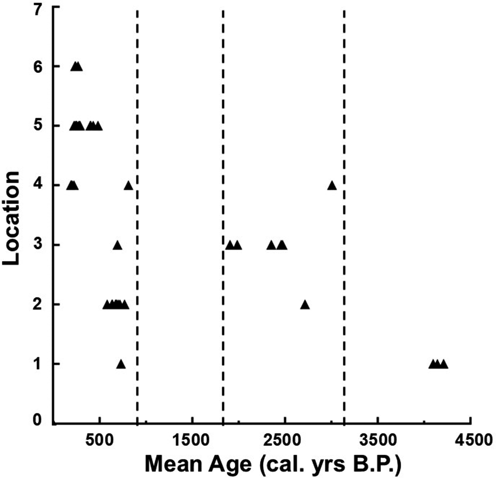
Radiocarbon dates here were completed on Adélie penguin tissues recovered from excavations of abandoned breeding sites that were located and sampled in the Clear Lake, Cape Royds and Cape Barne areas of Ross Island. All dates were completed at the University of Georgia Center for Isotopic Studies Accelerator Mass Spectrometry (AMS) facility (UGAMS), Beta Analytic, Miami, Florida (BETA), the University of California, Irvine AMS facility (UCIAMS) or Woods Hole Oceanographic Institution, National Ocean Sciences AMS facility (NOSAMS). All tissues that were dated except eggshell and eggshell membrane were from chicks, including bone, feathers and skin from mummies. The uncorrected radiocarbon dates reported by Spellerberg (Reference Spellerberg1970) and Stonehouse (Reference Stonehouse1970) at Clear Lake (NZ 1045) and Cape Barne (NZ 677, 1042–1044) were obtained from the Rafter Radiocarbon Laboratory, Institute of Geological and Nuclear Sciences, New Zealand, with their laboratory (NZ) numbers (Table I). All radiocarbon dates, including these, were corrected and calibrated for the marine carbon reservoir effect using the Calib 8.2 program (Stuiver & Reimer Reference Stuiver and Reimer1993) and a ΔR of 609 ± 137 following the new calculations for the Ross Sea by Gao et al. (Reference Gao, Cristina Salvatore, Xu, Yang, Sun, Xie and Baroni2022). The dates are reported here in calendar years (cal. yrs) bp with a 2σ range (Table II). The mean point of these ranges was used to plot the calibrated dates of abandoned sites in three areas: those located in the vicinity of Coast and Clear lakes and northward, those at Cape Royds and north to Coast Lake and those at Cape Barne. To further assess any patterns in the occupation history of penguins in these regions, sites with radiocarbon dates were ranked by their location from north to south from 1 to 6, respectively. Sites clustered in one area were given the same rank.
Radiocarbon dates on Adélie penguin tissues recovered from abandoned breeding sites listed in Table I in the Cape Royds and Cape Barne region. All dates were calibrated for the marine carbon reservoir effect with Calib 8.2 with ΔR = 609 ± 137 years to yield a 2σ range in calendar years bp. The mean of each range was used to plot each date by its rank (Table I) in Fig. 4.

Table II. Long description
A table with six columns: Laboratory number, Site, Material, 14 C age yrs B P, Mean calibrated age (cal. yrs B P), and 2 sigma range.
The table documents a wide range of samples including bone fragments, eggshells, feathers, and mummy tissues, with uncorrected 14 C ages ranging from approximately 1060 to 4890 yrs B P.
Results
A total of 49 radiocarbon dates have been completed on penguin tissues from the Cape Royds and Cape Barne regions, including 31 newly reported here (Tables I & II). Two of these new dates are from the same chick mummy recovered from Cape Barne dated by Emslie et al. (Reference Emslie, Berkman, Ainley, Coats and Polito2003) at 2187 ± 70 14C yrs bp (NZA 13371). The two new dates (UGAMS 69031 and NOSAMS 192400) completed at two separate laboratories indicate that this original date is incorrect and that the mean age of this specimen is much younger, at 1540–1640 14C yrs bp or ~400 cal. yrs bp, which is more in line with other dated tissues from this site (Table II). Thus, the incorrect date in Emslie et al. (Reference Emslie, Berkman, Ainley, Coats and Polito2003) is not included in the analyses here, and the two new dates are averaged and plotted as one date for this mummy at 400 cal. yrs bp in Fig. 4.
Plot of mean calibrated radiocarbon dates from abandoned penguin breeding sites ranked 1–6 from the farthest northern site to the most southern, respectively. Vertical dashed lines highlight the three occupation periods represented by these dates: ~4100 cal. yrs bp at the most northern site (CLN4), ~1900–3000 cal. yrs bp at sites north of Cape Royds and ~225–800 cal. yrs bp at Cape Barne and Cape Royds to Clear Lake.

Figure 4 Long description
A scatter plot with the X axis labeled Mean Age (cal. yrs B. P.) ranging from 0 to 4500 and the Y axis labeled Location ranging from 0 to 7. Data points are represented by black triangles. Three vertical dashed lines divide the plot into chronological zones.
* The first zone (left), from 0 to approximately 900 cal. yrs B. P., contains a high density of points at locations 2, 3, 4, 5, and 6, with one point at location 1.
* The second zone (middle), between approximately 1800 and 3100 cal. yrs B. P., shows a sparse distribution of points at locations 2, 3, and 4.
* The third zone (right), centered around 4100 cal. yrs B. P., contains a small cluster of points exclusively at location 1.
When dated sites are plotted from north to south (Fig. 4), at least three distinct occupation periods are revealed, with the youngest dates split between the most northern (north of Clear Lake) and southern locations at Cape Barne, with a few other sites south of Coast Lake included. The vast majority of radiocarbon dates (38 of 49) fall within the past 800 years, with short and tightly dated occupation of sites occurring north of Clear Lake at ~600–800 bp, and at Cape Barne at ~225–483 bp. The occupation at Cape Barne appears to have been a large concentration of birds over many decades given the size of the pebble concentration at ~100 m north-south and 70–75 m east-west and the extent of the ornithogenic soils that are up to 20 cm deep with relatively abundant penguin remains, including numerous chick mummies. All other abandoned pebble areas sampled here are much smaller and shallower, including those at Coast and Clear lakes and to the north. These sites consist of pebble concentrations that are typically only 3–4 m in diameter with shallow ornithogenic soils that are only 5–10 cm deep, suggesting a shorter occupation period than that at Cape Royds or Cape Barne. All of the sites north of Clear Lake and those at Cape Barne have remained unoccupied since they were abandoned except for occasional small numbers of nesting pairs that were recorded by Spellerberg (Reference Spellerberg1970) in the summers of 1963–1964 and 1965–1966 and by Taylor & Wilson (Reference Taylor and Wilson1990) in 1988–1989. In addition, a small number of nesting pairs were noted at the edge of Horseshoe Bay and at Cape Barne in the late 1990s (D. Ainley, personal communication, Reference Wood, Zhou, Cole, Coleman, Anderson and Lyver2025). No nesting pairs were observed at Cape Barne by the author during a sampling visit there in January 2001, and none have been reported since then.
A second occupation period falls between ~1900 and 3000 cal. yrs bp at Cape Royds and sites to the north, mostly near Clear Lake, but with one further to the north (CLN4) that dated to 4097–4209 cal. yrs bp. The former date range may not have been continuous, as it is based on only seven widely dispersed radiocarbon dates (Fig. 4), but it indicates that there were at least one or two early occupations of this area. These dates also indicate that Adélie penguins were breeding in the area during the ‘penguin optimum’ at ~2000–4000 cal. yrs bp when a warming period allowed occupation of the Scott Coast across McMurdo Sound and opposite to the south-west coast of Ross Island (Baroni & Orombelli 1992, Emslie et al. Reference Emslie, Berkman, Ainley, Coats and Polito2003, Reference Emslie, Coats and Licht2007). Marble Point, the most southern occupation on the Scott Coast, is directly across McMurdo Sound from Cape Royds and was occupied periodically from ~2000 to 4000 cal. yrs bp (Baroni & Orombelli Reference Baroni and Orombelli1994, Emslie et al. Reference Emslie, Berkman, Ainley, Coats and Polito2003, Wood et al. Reference Wood, Zhou, Cole, Coleman, Anderson and Lyver2025). The three similar radiocarbon dates at the most northern abandoned colony north of Clear Lake sampled here, CLN4, indicate an even earlier but brief occupation of this area at ~4100 cal. yrs bp.
Discussion
The data presented here still indicate that the active colony of Adélie penguins at Cape Royds has been occupied for at least the past 800 years, although the size of the colony probably varied over the centuries, as it has historically. Since 1955, the colony has ranged from less than 1000 to over 4000 breeding pairs, with this variation affected by a number of both anthropogenic and environmental variables (Ainley et al. Reference Ainley, Morandini, Barton, Lyver, Elrod, LaRue and Pennycook2024). A synthesis of the historical data using multivariate analysis by Ainley et al. (Reference Ainley, Morandini, Barton, Lyver, Elrod, LaRue and Pennycook2024) sought to determine those variables that most influenced population changes at the Cape Royds colony over the past 6 decades. These same variables (gyre speed, wind speed, ice cover), except for direct anthropogenic disturbances (human visitor disturbance, fishing), are assumed to have affected population expansion and contraction in the Cape Royds and Cape Barne regions over the past 3–4 millennia as well. Central to this variation has been persistence and seasonality of the McMurdo Sound polynya, with its southern boundary at the fast-ice edge typically at Cape Royds (Kim et al. Reference Kim, Saenz, Scanniello, Daly and Ainley2018, Ainley et al. Reference Ainley, Morandini, Barton, Lyver, Elrod, LaRue and Pennycook2024).
Given that areas near beach access points to the north of Cape Royds, at Coast Lake and northward, were occupied by breeding penguins from ~600 to 800 cal. yrs bp, this supports the conclusion that Cape Royds was continuously occupied throughout this period as well. However, so far, there is no evidence for the occupation of the Cape Royds colony during the ‘penguin optimum’ (~2000–4000 cal. yrs bp; Baroni & Orombelli Reference Baroni and Orombelli1994, Emslie et al. Reference Emslie, Coats and Licht2007), despite the fact that the most northern colonies (CL3 and CLN4) were at least sporadically occupied at that time. A cooling period following this ‘optimum’ is probably when fast ice began blocking the Scott Coast, as it still does today, preventing reoccupation of this coast by breeding penguins since ~2000 cal. yrs bp. This period of cooling could also explain the ~1000 year gap in penguin occupation on the south-western coast of Ross Island from ~1900 to 800 cal. yrs bp (Fig. 4).
Farther south, at Cape Barne, environmental factors have been important in the occupation of that site, which was probably quite variable in relation to fast-ice conditions and beach accessibility over the past ~400 years. Open water access to the beach at Cape Barne by early summer would be necessary for that site to be occupied, and its heavy use by breeding penguins from ~225 to 483 cal. yrs bp suggests that this was the case during this period. The tight correspondence of radiocarbon dates from this site (19 dates on 18 specimens; Table I) indicates a relatively brief but continuous occupation that ended ~225 cal. yrs bp. The periodic 1–2 year occupations of Cape Barne documented in the 1960s and late 1980s were probably facilitated by the early breakout of fast ice in the spring/summer, allowing penguins access to the beach there.
This period of occupation at Cape Barne also corresponds in timing to the Little Ice Age (LIA; 1300–1850 ce), when Antarctica experienced ~2°C cooler conditions than at present (Bertler et al. Reference Bertler, Mayewski and Carter2011). A southward expansion of breeding penguins in the Ross Sea seems at odds with this global climatic event. However, studies indicate that increased katabatic winds during the LIA created an enlarged Ross Sea polynya with higher productivity than today and less ice in the eastern Ross Sea (Rhodes et al. Reference Rhodes, Bertler, Baker, Steen-Larsen, Sneed, Morgenstern and Johnsen2012). Moreover, ice-core data from Roosevelt Island in the eastern Ross Sea have shown opposite climatic effects from ice cores in the western Ross Sea, with warmer conditions in the east, referred to as the Ross Sea dipole (Bertler et al. Reference Bertler, Conway, Dahl-Jensen, Emanuelsson, Winstrup and Vallelonga2018). Although their data restrict the eastern Ross Sea to Roosevelt Island and Siple Dome, it appears that the warmer conditions and presence of an enlarged McMurdo Sound polynya extended to the south-western side of Ross Island, as is also evinced by the penguin occupation at Cape Barne. Finally, sediment records at Cape Bird on the north-west coast of Ross Island also indicate occupation by breeding penguins there by ~700 cal. yrs bp, with peak numbers occurring during the LIA (Hu et al. Reference Hu, Sun, Xie, Emslie and Liu2013) and with some movement occurring within the colony to higher-elevation breeding sites (Nie et al. Reference Nie, Sun, Liu and Emslie2015). Once the LIA ended, increased sea and fast ice ended the occupation of Cape Barne by breeding penguins.
Given current warming trends in the Ross Sea, with summer temperatures rising by 0.5°C per decade since the 1980s (Ainley et al. Reference Ainley, Clarke, Arrigo, Fraser, Kato, Barton and Wilson2005, LaRue et al. Reference LaRue, Ainley, Swanson, Dugger, Lyver, Barton and Ballard2013), it is probable that nesting by Adélie penguins will once again be possible at Cape Barne and other localities north of Cape Royds, as well as along the Scott Coast, if fast ice begins to break out early enough each summer. If so, the McMurdo Sound polynya will become increasingly important as a future foraging ground for increasing numbers of Adélie penguins in the southern Ross Sea.
Acknowledgements
I thank Rodger Sparks of the Rafter Radiocarbon Laboratory, New Zealand, for providing additional information on radiocarbon dates completed in their laboratory in the 1960s. Colin Monteath kindly provided an original copy of Frank Debenham’s map of Cape Royds and Cape Barne that was reproduced here by Melissa Smith, UNCW Center for Marine Science. Fieldwork at Cape Royds and Cape Barne was completed with the assistance of L. Coats, Dave and Seb Hayman, V. Munoz, M. Polito, K. Sutherland and J. Zuluaga, with logistical support from McMurdo Station and the US Antarctic Program, as well as from Heritage Expeditions, New Zealand, and the staff and crew of the tour ship Heritage Adventurer. D. Ainley provided useful comments on an earlier draft of this paper, as did two anonymous reviewers.
Financial support
This research was funded by NSF Grant OPP-2135695.
Competing interests
The author declares none.



 Open access

