INTRODUCTION
In the Mexican highlands, where geography conspires against the fluidity of exchange, Mesoamerican societies have been able to create technical responses adapted to their needs. At a time when transport of goods and merchandise was mainly carried out on peoples’ backs, some civilizations turned to a watery environment. Here starts the adventure of Tenochtitlan, in the fourteenth century, amidst the inhospitable swamps of Lake Texcoco. Founded on a natural islet that the tribal god Huitzilopochtli is said to have designated, within 200 years it had become the center of the Aztec Empire. The construction and urbanism of the largest lacustrine city in the New World required colossal construction work and a great deal of imagination, coupled with unparalleled ingenuity (Castillo Farreras Reference Castillo Farreras1969).
The Basin of Mexico, at an altitude of more than 2,000 m, is surrounded by high volcanic mountain ranges, punctuated by summits that dominate the landscape, such as the Popocatépetl (5,452 m) and the Iztaccíhuatl (5,230 m). From these mountains flowed numerous streams and rivers that fed, according to the rhythm of the seasons, five shallow lakes, established at different altitudes: to the north, the lakes of Zumpango and Xaltocan; in the center, the lowest, the great lake of Texcoco; and to the south, the lakes of Xochimilco and Chalco. These bodies of water occupied an area of between 8,000 and 10,000 km2, one-seventh of the total surface area of the Basin. The lakes are interconnected, but the entire system of lakes is isolated, so that excess rainwater has no natural way to run off. This caused frequent flooding episodes in the rainy season, some of which often devasted the great city of Tenochtitlan. Another particularity of this lake area was that it contained both fresh and brackish water. The northern lakes were slightly saline; Lake Texcoco, where the Aztec capital was founded, was loaded with a high concentration of salt; and only the southern lakes were composed of fresh water.
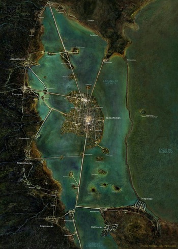
Topography, geology, and hydrography were therefore fundamental factors in the anthropization and urbanism of the lacustrine cultural landscape of the Basin of Mexico. At the beginning of the sixteenth century, all the major hydraulic works in the lagoon around Tenochtitlan belonged to the Aztec authority, although some of these works were built before their hegemony over the entire Basin of Mexico (Carballal Staedtler and Flores Hernández Reference Carballal Staedtler and Flores Hernández2004:31). The insular situation of Tenochtitlan soon gave rise to large-scale works to develop the lacustrine area of Lake Texcoco. The extensive hydraulic works carried out mainly by the Aztecs (although their allies and predecessors began as early as the fifteenth century) were direct responses to environmental problems (Sanders et al. Reference Sanders, Parsons and Santley1979:Map 19): reducing the risk of flooding during the rainy season; attempting to reduce the salinity of the waters surrounding Tenochtitlan; connecting the capital to the shores by causeways; and supplying the island capital with drinking water (Figure 1).
Tenochtitlan, its causeways, and the Nezahualcoyotl dike. Map by Tomás Filsinger.

When Cortés arrived in a.d. 1519, the capital of the Aztec Empire was a lacustrine city covering 13.5 km2, with a population of slightly more than 250,000 inhabitants. In comparison, Venice had only half as many inhabitants at that time. It was from the island of Tenochtitlan that the last Aztec emperor, Moctezuma II, controlled a territory of approximately 200,000 km2, where about four hundred cities were organized in 38 provinces subject to tribute. The island of Tenochtitlan had become the heart of the largest empire in Mesoamerica in less than two hundred years by mastering and exploiting water transport as a continuation of land routes. The city was divided into four distinct districts, called Atzacualco, Cuepopan, Moyotlan, and Teopan, which represented the four cardinal points of the universe. Their distribution was materialized by four large causeways, interspersed with removable bridges, which guaranteed the only access to the metropolis by land. At its center was the sacred enclosure (recinto sagrado), which comprised an area estimated at about 12 hectares, at the heart of which stood numerous temples, including the famous Templo Mayor discovered in 1978. This nucleus was the religious, political, and economic center, symbolizing the absolute, centralized power of the Aztec Empire. This ideological urban planning of Tenochtitlan represented the quintessence of the Aztec conception of the world, where aquatic roads played a major but thus far underestimated role.
To achieve an understanding of Tenochtitlan, we have to adopt an aquatic point of view because the Aztecs were a lacustrine culture (Biar Reference Biar2020). Godelier (Reference Godelier1978:172) stated that the idéel (mental) “is thought in all these functions, present and acting in all the activities of man, who exists only in society.” An aquatic point of view could explain how the perception and exploitation of the lacustrine environment of the Basin of Mexico was an idéelle reality for pre-Hispanic navigators that allowed them to make the lacustrine cultural landscape visible and intelligible—that is, that lakes are an element of centrality and continuity. To understand more accurately the mental reality of these water-based societies for whom these vast expanses do not isolate but connect (Guiot et al. Reference Guiot2013), it was essential for me to shift my reasoning from lakes to shores and beyond (Pétrequin Reference Pétrequin1994:133) where the aquatic environment was considered as a displacement surface. The island nature of Tenochtitlan is made up of a body of knowledge, both personal and collective, which can, in part, be grouped under the term navigation. For this reason, the navigators of the Mexican Central High Plateau crisscrossed the island of Tenochtitlan in three dimensions and for multiple functions, creating a layer of social geography. Their dugout canoes then became mobile places at the origin of social, political, administrative, and economic interactions (Bérard Reference Bérard2018) associated with specific installations. These anthropic markers thus revealed to the Europeans, who were uninitiated, the presence of a complex communication network, based on the continuity of aquatic and terrestrial routes (Lugo and Gershenson Reference Lugo, Gershenson, Glass, Colbaugh, Ormerod and Tsao2012).
But how can these lacustrine installations be identified and located when the lacustrine cultural landscape has disappeared, buried under what is now Mexico City? Using a multidisciplinary methodology based on archaeological data and on ethnohistorical, pictographic, and iconographic documents from the sixteenth to the twenty-first century, I propose to group these data according to the specific functional needs of the inhabitants. I have chosen not to integrate the work related to paleoenvironmental (Manzanilla and Serra Puche Reference Manzanilla and Serra Puche2013; Musset Reference Musset1992; Niederberger Reference Niederberger1976, Reference Niederberger1987; Rabiela Rojas et al. Reference Rabiela Rojas, Strauss and Lamerias1998; Sanders et al. Reference Sanders, Parsons and Santley1979) and geoarchaeological (Mundy and Miller Reference Mundy and Miller1998, Reference Mundy, Miller, Raaflaub and Talbert2010; Palerm Reference Palerm1973; Parsons Reference Parsons2013; Sanders and Price Reference Sanders and Price1984) studies here, in order to maintain focus on the installations.
ANTHROPIC MARKERS: TRANSITION AND COORDINATION BETWEEN WATER AND LAND
On the basis of Westerdahl's (Reference Westerdahl2006) work in maritime archaeology, which I adapt to the lacustrine environment of Tenochtitlan, I distinguish two types of anthropic markers related to aquatic transport activities: those associated with a transition dynamic and those associated with a coordination dynamic. Each of them should be conceived as the materialization of connections between two environments—a connection that is aimed at the continuity and fluidity of interactions and exchanges.
Transition Area
A transition area is a natural or artificial space that organizationally materializes the continuity that exists between lacustrine and land routes. According to Westerdahl (Reference Westerdahl2007:101), a transition area can also be considered as belonging to a “transport zone.” It is possible to observe the markers of successive land use planning that aim to facilitate the transfer between different transport technologies to help the traffic become more fluid. In accordance with this definition and both archaeological and ethnohistorical data, I distinguish two types of transition areas within the urban context of Tenochtitlan: landing stages and wharfs.
Landing Stage
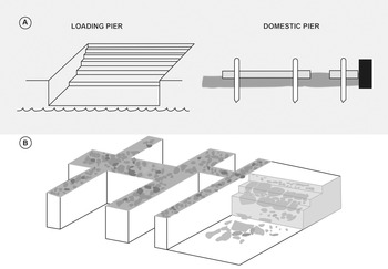
A landing stage is defined here as a flat structure to take goods or passengers on or off watercraft. In other words, it is an artificial area that requires the construction of a site that is essential for the transition from an aquatic to a terrestrial environment. Archaeologically, in Tenochtitlan, González Rúl (Reference González Rúl1998:35) distinguishes two types of landing stage: loading stages and domestic piers (Figure 2). The first type was a masonry structure designed to support heavy daily commercial activity involving the transfer of large volumes of goods. Easily identifiable, these loading stages were composed of a few steps that provided a stable transition between lacustrine and land environments. The second type was an inexpensive structure that resembled a wharf. According to González Rúl et al. (Reference Rúl, Francisco, Palacios and Hernández1996:20; González Rúl Reference González Rúl1998:34), domestic piers are platforms supported by piles or pilings, intended for the docking and mooring of boats to facilitate loading and unloading. Loading piers were found in Mexico City during rescue excavations precipitated by the urbanization of the megalopolis's historic center. These domestic loading piers were unearthed in two different archaeological contexts, one communal, connected to commercial uses, the other private, associated with an imperial residential building and mainly associated with a formal route, or acequia.
(a) A loading pier characterized by a masonry staircase, and a domestic pier likely to be made of wood to give greater flexibility to the structure (González Rúl et al. Reference Rúl, Francisco, Palacios and Hernández1996). (b) Communal loading pier at Atlixco identified as a masonry staircase, built from local basalt stones (Sánchez Nava Reference Sánchez Nava1984).

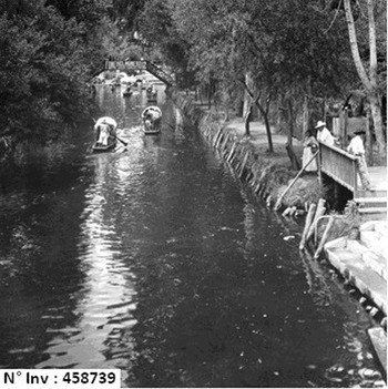
In a communal context, Hernández Pons (Reference Hernández Pons2002:79) points out the presence of a loading pier on the current Avenida Corregidora, which follows the route of the Acequia Real. This structure consists of a few masonry steps (Figure 3) built next to another structure identified as a bridge. Its location, at the foot of a land road, implies, in my opinion, a use reserved for the transit of goods or people, accessible by anyone. The nature of this community pier leads me to hypothesize that there must have been a number of such piers near a number of bridges to facilitate transit and trade. However, although they are real structures that can be identified at the archaeological level, these piers must have been rather crude, sometimes even invisible above the water surface, making the banks around the footbridges into elementary transition zones.
Loading dock on the banks of one of Xochimilco's shipping canals in the 1900s. Image by Sylvie Elies based on the Casassola collection, Sistema Nacional de Fototecas.

The most documented structure is the communal pier located at Atlixco, a site within the Teopan District of ancient Tenochtitlan, in the southeastern part of the island (Sánchez Nava Reference Sánchez Nava1984:71). The very location of this site suggests a use linked to interregional exchange—that is, in connection with the riparian communities of Lake Texcoco. The archaeological data obtained have made it possible to identify Atlixco as a site of artisanal and food production. All the material, especially the ceramics, indicates that this site was permanently occupied from the end of the Early Postclassic to the early years of the Colonial period (Sánchez Nava Reference Sánchez Nava1984:95). As a redistribution point for consumer goods, it has a loading pier, in the form of a masonry staircase, built from local basalt stones. The structure extended 2.10 m from north to south and 3.80 m from east to west (Sánchez Nava Reference Sánchez Nava1984:71). It had two steps measuring 40 cm high and 40 cm deep. More interestingly, at the foot of this structure, 205 artifacts were discovered, including complete vessels and anthropomorphic figures (Sánchez Nava Reference Sánchez Nava1984:84). The archaeologists concluded that the majority of the vases must have been an offering dedicated to the structure itself and to the commercial activities it supported (Sánchez Nava Reference Sánchez Nava1984:85). The uncovering of such an offering is exceptional, and no comparable offering has been excavated to date. However, it seems possible that other offerings of this type were made. In this context, I note the existence of a deposit of complete ceramics discovered during the excavations of the Acequia Real. In future research, I plan to compare them to see if their functions are similar. The publication by González Rúl (Reference González Rúl1998:34) is, to my knowledge, the most recent to mention the excavation of a loading pier as part of the rescue excavations carried out during the construction of Line 4 of the Mexico City metro. Thanks to iconographic data, such as photographs from the first half of the twentieth century, it is possible to illustrate structures similar to those found in archaeological contexts, but the lack of information about their precise location and period of construction precludes any historical or archaeological interpretation. In addition, there is no archaeological equivalent for the pre-Hispanic period along other parts of the ancient shores of the lacustrine system of the Basin of Mexico that might be used for comparison.
Private loading piers in domestic contexts were discovered during excavations carried out along the Acequia Real route in the 1980s (González Aparicio Reference González Aparicio1980). One of them is a small loading pier formed by a small masonry staircase at the entrance of one of the Casa Nuevas of the Emperor Moctezuma II, now buried under the Palacio Nacional (Corona Reference Corona1994; Hernández Pons Reference Hernández Pons2002:65). Similar structures have been identified in the different stretches of the Calle Venezuela, which in pre-Hispanic times was located near the Recinto Sagrado, where the Templo Mayor stood. Today, buried under the Sindicato Nacional de Maestros (SNTE) building, this small loading dock belonged to a house of the Mexican elite (Hernández Pons Reference Hernández Pons2002:65). These two archaeological examples, due to their geographical location in the heart of the capital, tend to prove the existence of private landing stages located in the houses of the Mexican elite, and even in the heart of the houses of the emperor. I hope in the future that new discoveries will reveal unknown facilities to the increase the sample size of this form.
Two other types of landing stage in a domestic context could be identified from archaeological data. The first type, according to González Rúl (Reference González Rúl1998), is a more rustic domestic loading pier, comprising a platform constructed from wooden planks with holes at their ends so that they could be supported on stilts. This technique would have given greater flexibility to the structure and allowed it to adapt to the constant fluctuations of the water level in the Tenochtitlan lagoon. To my knowledge, there is only one mention of such a pier in the urban context of Tenochtitlan, identified by González Rúl (Reference González Rúl1998:34) during the excavations of the Conjunto Bancen, between 1985 and 1987 (Lefèbvre Reference Lefèbvre2004:101). The lack of new archaeological discoveries of such unsophisticated structures must be associated, on the one hand, with the difficulty of access to the remains in the historic center of the capital and, on the other hand, with the difficulty of identifying such structures due to the nature of the building materials and their preservation. The second type was identified during my research in Mexico City in 2011, with the help of Instituto Nacional de Antropología e Historia (INAH) archaeologist Eladio Terreros Espinosa, in the form of a pre-Hispanic house that could be considered a domestic loading pier in itself. The very architecture of the Casa Talavera, a colonial building dating from the seventeenth century built on an ancient pre-Hispanic construction located in the old district of Temazcaltitlán, provided direct access to one of the capital's formal navigation waterways. Following the restoration of this building, the Maestra Graciela Sánchez (personal communication 2012) identified in the rear part of it a direct access point to the Acequia de Roldán. A similar observation was made by Calnek (Reference Calnek1972:106) and Hernández Pons (Reference Hernández Pons2002:37), who state that the rear of the pre-Hispanic and later colonial houses in Tenochtitlan had direct access to a navigation canal to facilitate the delivery of supplies. Ethnohistoric accounts confirm this access in the descriptions of the ancient Aztec city by Conquistadors such as Díaz del Castillo (Reference Díaz del Castillo and Denis2009:chap. XCII, p. 345) and Torquemada (Hernández Pons Reference Hernández Pons2002:37). My hypothesis is that this transition zone, between the canal and the domestic space, should be considered as forming part of the type of domestic piers (Biar Reference Biar2018:225–226). Indeed, the latter seems to have been arranged in such a way as to facilitate the exchange of goods from the canal by the presence of a system of sliding doors leading toward the interior of the house where there is a small platform to make the transition. I anticipate that further archaeological excavations on this type of dwelling will reveal that other domestic buildings located along the waterways within the urban context were also equipped with this type of layout during the pre-Hispanic period. There seem to be many variations on the landing stage, whether in a communal or a domestic context, and this variation reveals the ability of the Aztecs to convert the lacustrine environment by exploiting every available space. Designed to facilitate the circulation and access of millions of watercraft in the heart of Tenochtitlan, these transition areas were structures that favored the passage from one environment to another in complete continuity.
Wharf
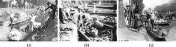
A wharf is defined here as a structure built in a port or on a shore (river, lake), used for mooring ships, embarking and disembarking passengers, and loading and unloading cargo. It is therefore an artificial zone that seems to have had a dual purpose: protecting the shoreline and functioning as a transition area. Applying this definition, we can identify some wharfs in the heart of the Aztec capital. We have already seen that the dikes and causeways built on the lakes of the Basin of Mexico protected the island of Tenochtitlan from flooding, especially during the rainy season, to the extent that this was possible. Within the city, they also functioned as a transition zone, as a wharf to facilitate trade. I did not find any descriptions in the sixteenth-century ethnohistorical sources. Yet the sources I did find—namely, some photographs from the early twentieth century—seem to me relevant enough to be considered in my argument. These pictures illustrate uses of the banks along shipping waterways (Figure 4). According to the photos, it would seem that not all the goods transported by water to the capital were destined to supply the main markets, such as Tlatelolco or La Merced. In fact, some texts from the twentieth century mention the practice of an itinerant and opportunistic trade that traveled in search of its clientele (Marroquí Reference Marroquí1900:vol. 2, p. 60). Elsewhere, I have proposed that such transactions were carried out on the wharfs (Biar Reference Biar2018:209). It is possible to imagine the use of such spaces in pre-Hispanic times because of their utility. Indeed, the use of these wharfs would be a satisfying solution to the limited commercial spaces accessible by water transport in Tenochtitlan. Unfortunately, as facilities suitable for the practice of navigation, wharfs have not been the subject of archaeological excavations or specific scientific work in the Basin of Mexico.
Three uses of the banks along shipping waterways in the 1900s. (a) Flower trade along the Canal de la Viga banks; (b) transport and trade of vegetables from the Chinampera production in the lake area; (c) flower trade on the banks of a canal during the Viernes de Dolores festival. Images by Sylvie Elies based on the Casassola collection, Sistema Nacional de Fototecas.

In conclusion, the development of artificial transition zones (landing stages, quays), generally located on the banks, would provide an organizational response to the need to switch from one means of transport to another. These areas would then materialize the ephemeral passage, or transit, that exists between lake roads and land-based roads. Westerdahl (Reference Westerdahl2006:101) considers that these intermediary spaces can also be referred to as a “transport zone,” due to their intermediary role. However, due to a permanent need for maintenance of transport systems, whether lake- or land-based, they cannot operate without the support of facilities dedicated to the control and storage of the means of transport, passengers, and goods.
Coordination Area
Whereas transition zones, with their restricted spaces, are characterized by the rapid transfer of merchandise to avoid hindering foot traffic, coordination zones are mainly characterized by the need to control and store the means of transport and their cargoes. These areas will therefore be identifiable through the presence of specific infrastructure in relation to the practice of navigation. Again, relying on Westerdahl (Reference Westerdahl2007), I have identified five types in the urban context of Tenochtitlan: ports, customs facilities, warehouses, bridges, and dockyards, which may be superimposed on the same site. Each of these facilities is dependent on the others to crystallize either an economic or a military center indispensable to the proper functioning of the local political authority.
Ports
A port is defined as a natural or artificial shelter designed to receive boats and to ensure their loading and unloading as well as their maintenance.
Customs facilities
Customs facilities are understood as points implemented in a geographical or artificial border between land and aquatic routes, administrated by a central power that collects taxes paid on goods coming in and out of the urban Tenochtitlan or the Basin of Mexico itself, for the purpose of regulating the market economy.
Warehouses
A warehouse is a large building to stock goods before they are sold, used, or sent out to market places or elite houses and palaces.
Bridges
They are artificial structures built over waterways to allow people and canoes to cross and circulate continuously from one environment to another.
Dockyards
This is a place administrated by a local or central power where canoes are stored, equipped, decorated and repaired.
ARCHAEOLOGICAL REMAINS OF ACTIVITIES CONNECTED TO LACUSTRINE WATERWAYS
The study of the political and economic exploitation of the insularity of Tenochtitlan through the identification of its anthropic markers is only a small part of the logistics and administration infrastructure that was much more complex than it appeared. Where were ports located? What is known about the customs system? Where were the imperial warehouses located? What was the role of bridges? What was the purpose of a dockyard for the imperial or military naval force? Resorting again to a multidisciplinary approach, I address these questions, which have been neglected to date due to the scarcity of archaeological, rather than ethnographic, data.
Ports
A port is not only a place of anchorage or exchange, as the transition zones are, but a developed area that concentrates the physical infrastructure necessary for loading and unloading operations, tax control and assessment, storage of goods, and the organization of the redistribution of goods (Nieto Reference Nieto and Pomey1997:154). According to Nieto (Reference Nieto1988, Reference Nieto and Pomey1997) and Arnaud (Reference Arnaud, Delestre and Marchesi2010, Reference Arnaud, Wilson and Robinson2011), for the Mediterranean Basin it is possible to differentiate between two types of ports: main and secondary. A main port is an area with administrative, technical, and economic infrastructure adapted to long-distance trade. There are spaces designed to facilitate the transit and storage of cargoes characterized by a very large volume. A secondary port, on the other hand, is placed directly under the influence of the nearest main port. These two facilities are therefore differentiated by the volume of trade that takes place there (Arnaud Reference Arnaud, Delestre and Marchesi2010:110). Whatever their rank, the image of ports as urban façades is perfectly planned to reflect the power of the city that administers them (Arnaud Reference Arnaud, Delestre and Marchesi2010:110).
These ideas about ports from Nieto and Arnaud can be applied to the lacustrine environment of the Basin of Mexico. Although the scale is smaller and the very nature of the lake environment and its extent are less restrictive, the navigation needs are more or less the same. Through the reading of ethnohistorical sources from the sixteenth century, such as Cortés (Reference Cortés and Charnay1982) and Sahagún (Reference Sahagún, Jourdanet and Siméon1981), to scientific works from the nineteenth and twentieth centuries, such as the ones from Orozco y Berra (Reference Orozco y Berra1864) and Marroquí (Reference Marroquí1900), I have identified three types of ports: main, secondary, and auxiliary. The first two fit in perfectly with the definitions given by Nieto (Reference Nieto1988, Reference Nieto and Pomey1997) and Arnaud (Reference Arnaud, Delestre and Marchesi2010, Reference Arnaud, Wilson and Robinson2011), although we have to consider that in the colonial sources of the sixteenth and seventeenth centuries, the concept of the port was not as precise. It was used in the same way as the words pier or landing stage, simply to designate a place where important exchanges took place between the lake and land environments. Because in ethnohistoric sources the word port is used to designate a place where key exchanges took place, it is necessary to define, in a scientific way, what such a place would look like archaeologically, in order to be able to accurately identify it during excavation and not confuse it with another type of installation. Although archaeological evidence is almost non-existent, the descriptions provided by the Conquistadors, together with current scientific data, are, I argue, sufficiently precise to support my identification of port areas (Ciudad Real et al. Reference Ciudad Real, Quintana, Castillo Farreras and Gurría Lacroix1976:vol. 1, p. 121; Clavijero Reference Clavijero1974:298; Cortés Reference Cortés and Charnay1982:128; Gibson Reference Gibson1964:364; Archivo General de la Nación in Hassig Reference Hassig1985:293).
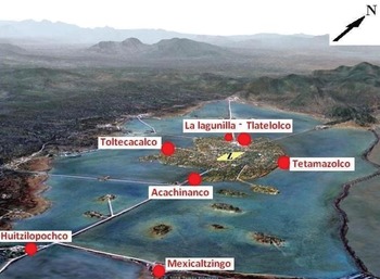
Each of the five main ports (Figure 5) I identified (Biar Reference Biar2018:216–220) is located at the four cardinal points that structure the entire urban layout of the island: Tlatelolco and La Lagunilla to the north, Acachinanco to the south, Tetamazolco to the east, and Toltecacalco to the west (González Aparicio Reference González Aparicio1980; González Rúl Reference González Rúl1998:34; Hernández Pons Reference Hernández Pons2002:243; Lombardo de Ruíz Reference Lombardo de Ruíz1973:137–138; Marquina Reference Marquina1960). By observing their locations, one can better understand how these facilities played a coordinating role. Each of these ports is located on a causeway, a land road that connects the island of Tenochtitlan to the shores of the Mexico lagoon. The goods transported by lake road and those transported by land road converged there, although varying in amount. Even though these ports were considered to be the main ones, they were less extensive than those located in the southern lakes due to the limited space available. However, their control over the flow of goods entering the Core Area on a daily basis was very significant. Moreover, their location suggests a use, and certainly an administration, attached to the parcialidad in which they were located. The port of La Lagunilla would be attached to the teocalli of Cuepopan, that of Toltecacalco to the teocalli of Moyotlan, that of Acachinanco to the teocalli Teopan, and that of Tetamazolco to teocalli Atzacualco. These port developments are at the origin of all the axes of communication and exchange, both lacustrine and land-based. They are true strategic points, both economically and religiously. Consequently, the division of the navigable space between these two entities leads to a specialization of the coordination areas according to the area of land activity to which it is attached.
The main ports, located at the four cardinal points, surrounding Tenochtitlan. The ports structured the entire urban layout of the island to coordinate land routes and waterways outside the urban center and control and smooth traffic flow (Biar Reference Biar2018:217).

Secondary ports are locations that are under the economic influence of the main ports because of the differences in the volume of transactions carried out there (Nieto Reference Nieto and Pomey1997:154–155). These ports are used primarily for coordinating the redistribution of goods from the main ports. Logic dictates that these would have been located close to the more residential areas, which would delimit a space of influence related to the daily needs of residents. I suggest seeking the location of such facilities by tracing informal waterways, which, in the context of Tenochtitlan, would have been associated with redistribution routes. In this urban context, I propose that cargo piers can also be considered as secondary ports because of their operation (Biar Reference Biar2018:225). Because the city was an island, the development of Tenochtitlan led to a hierarchy of port areas, which I interpret as a response to a strong anthropization of the lake landscape, placing insularity at the center of power. These areas of coordination appear to me to embody a fragmented management of the lacustrine space, modulated by its storage and control capacity, which in turn depends on its geographical position in relation to the capital. The closer ports are to the island, the more its storage capacity will decrease in favor of a more marked control, aiming at fluidifying the entire lake traffic, from the urban center toward the rest of the lake system (Biar Reference Biar2018:227–228). These coordination areas bring together trade routes, lake, and land, to meet political and economic needs and interests in the face of the need to provide subsistence income (Arnaud Reference Arnaud, Wilson and Robinson2011:65). This is why the ports define spaces linked to specific businesses that embodied a strong desire of central power, in order to claim the lacustrine exchange areas for itself. The presence of political authority that administers these coordination areas is manifested by the setting up of customs posts and other infrastructure that implies activities linked to water transport.
Customs Facilities
I hypothesize that in the Basin of Mexico, Tenochtitlan, with the help of its allies, played a leading role in the development of a port hierarchy between main ports, secondary ports, and auxiliary/transition areas—that is, landing stages and wharfs. The location and the study of the spatial distribution of port coordination zones are major elements in the process of appropriation of the shores and the construction of nautical boundaries in their military, administrative, and fiscal dimensions (Arnaud Reference Arnaud, Delestre and Marchesi2010:110). I suggest that evidence for this hierarchy can be found in Cortés's description (Reference Cortés and Charnay1982:132), however minimalist, of customs practices:
At all the entrances to the city, where the canoes are unloaded and where the various products used to feed the inhabitants accumulate, there are huts where the guards stay to collect a contribution for each product. I do not know whether this tax is for the benefit of the emperor or the city, I have not been told, but I believe it is for the benefit of the emperor, because in the markets of other provinces the tax was paid to the lord of the place.
While Cortés may have been ignorant about how customs procedures worked, and hence we are too, we can be confident that these procedures were a determining factor in the organization of trade in the lagoon around Tenochtitlan. Customs posts seem to be located, according to Cortés's description, close to coordination zones where there is sufficient space to accumulate perishable goods. According to Arnaud (Reference Arnaud, Delestre and Marchesi2010:111), customs in the Roman world structured both coastal space and trade practices, as they were at the origin of maritime routes and port systems. I would argue that they performed the same function in the heart of the Basin of Mexico. The fact that, of the 11 different types of tax among the Aztecs, three were levied for the benefit of the empire and eight were paid to the “city-state” (Smith Reference Smith2014:20) validates the hypothesis put forward and supported by Hicks (Reference Hicks, Claessen and Velde1987), Blanton and Fargher (Reference Blanton and Fargher2007), and Smith (Reference Smith2014), among others, that the levying of taxes on goods destined for the capital was a major source of revenue. Nantet (Reference Nantet2016:104), writing about the ancient Mediterranean world, distinguishes two types of taxes or duties, both levied at the heart of the port system: customs duties and port dues. Customs duties are fees calculated on the basis of the actual cargo carried by a vessel. Port dues, on the other hand, include all the fees that must be paid by the carrier for the use of the services offered by the port structure (pilotage, anchorage, unloading, and so on). Thus, the fees mentioned by Cortés seem to be customs duties rather than port fees.
Can we confirm that this type of tax existed in Tenochtitlan and the Basin of Mexico? Nantet (Reference Nantet2016:103–106) states that all of these taxes were assessed and levied according to the size of the vessel—that is, its carrying capacity. In the ancient Mediterranean, taxes were calculated according to the quantity of goods transported and according to the sale price set by the authorities (Arnaud Reference Arnaud, Wilson and Robinson2011:67). Cortés (Reference Cortés and Charnay1982:129) describes similar practices when describing the Tlatelolco market. The sale of goods was not by weight but by measure—that is, in batches (Hassig Reference Hassig1985:67). An evaluation of the vessel's loading capacity and of both the volume and the dimensions of the packaging of the goods transported would provide Aztec customs officers with a quick and efficient way to estimate the amount of tax that the merchant must pay. The high degree of organization of the lacustrine transport system was largely preserved after the fall of Tenochtitlan in 1521. The new colonial government simply replaced the pre-Hispanic administration and continued to levy taxes on the traffic of goods by canoe (Hassig Reference Hassig1985:211). Indigenous people retained a monopoly on all water transport traffic itself, whereas the Spaniards took control of the flow of goods throughout the Basin by augmenting the number of customs points (Hassig Reference Hassig1985:209). These coordination areas were referred to as garitas until the end of the nineteenth century. Although the available data are imprecise, it would appear that the Garita de San Lazaro was located at the main port site of Tetamazolco and that the Garita de la Viga was located at the main port site of Acachinanco (Biar Reference Biar2018:232). The research conducted on the ancient Garita de la Viga by Moreno Cabrera (Reference Moreno Cabrera1995) suggests that we may find pre-Hispanic archaeological remains of customs facilities along the ancient shoreline of Tenochtitlan island by taking into consideration that such sites may have been reused for a similar purpose during the colonial period.
To summarize, the location of both pre-Hispanic customs facilities and colonial garitas in the lagoon around Mexico-Tenochtitlan responded to commercial and political issues linked to the nature of the island capital. The levying of taxes and the authorization to enter or leave the capital were effective means of administering both lake and land transport, and of regulating traffic. However, although all goods were sold directly in the capital's markets, some of them had to be stored and then eventually redistributed. Buildings intended for storage then functioned as intermediate structures in the transportation of goods to their final destination. They had to be close to the banks or quays to facilitate the transition from one environment to another (Nantet Reference Nantet2016:337).
Warehouses and Dockyards
Coordination areas related to the storage of goods or merchandise are sites from which economic traffic routes are defined (De Rojas Reference De Rojas1986, Reference De Rojas and Mummet1987, Reference De Rojas, Michelet, Bortot and Darras2012, Reference De Rojas, Manzanilla and Rothman2016; Hassig Reference Hassig1985; Smith Reference Smith1996). Although archaeology has provided many confirmations of the relevance of these areas, little research has been done to study the architectural and organizational structure of these warehouses (Rovira Morgado Reference Rovira Morgado2014). In the Basin of Mexico, numerous studies that have been carried out on the economic structure of the Mexican Empire mention warehouses as a primary coordination area (Berdan Reference Berdan1980, Reference Berdan, Broda and Carrasco1982, Reference Berdan and Plattner1985, Reference Berdan1987, Reference Berdan and Sanderson1995, Reference Berdan2005; Berdan and Isaac Reference Berdan, Isaac and Isaac1986; Bueno Bravo Reference Bueno Bravo2012; Calnek Reference Calnek and Wolf1976, Reference Calnek, Schaedel, Hardoy and Scott-Kinzer1978, Reference Calnek, Sanders, Mastache de Escobar and Cobean2003; Carrasco Reference Carrasco, Carrasco and Broda1978, Reference Carrasco1996; Castillo Farreras Reference Castillo Farreras1996; Castillo Farreras et al. Reference Castillo Farreras and Teresa1991; De Rojas Reference De Rojas1983, Reference De Rojas, Ruíz, de León and Carmen Martínez Martínez2001, Reference De Rojas, Michelet, Bortot and Darras2012, Reference De Rojas, Manzanilla and Rothman2016; Gibson Reference Gibson1964; Hassig Reference Hassig1985; Hicks Reference Hicks and Bricker1986, Reference Hicks, Claessen and Velde1987; Hirth Reference Hirth2016; Hodges and Smith Reference Hodges and Smith1994; Lombardo de Ruíz Reference Lombardo de Ruíz1973; Mazzetto Reference Mazzetto2014; Rovira Morgado Reference Rovira Morgado2009; Sánchez et al. Reference Sánchez, Sánchez, Cedillo and López Wario2007; Sanders Reference Sanders and Meggers1968; Santley Reference Santley and Trombold1991; Smith Reference Smith1996). According to De Rojas (Reference De Rojas, Michelet, Bortot and Darras2012:109), the movement of goods required a network of temporary and permanent warehouses, which have to work simultaneously. The location of these sites in the heart of Tenochtitlan has not been exploited to its full potential. According to Rovira Morgado (Reference Rovira Morgado2014:182), the annual cereal and legume (maize, frijol, and chian) tribute paid to the island capital would have been approximately 9,200 tons. A certain proportion of these foodstuffs, estimated at a minimum of 16 percent (Rovira Morgado Reference Rovira Morgado2014:182), was destined to supply the garrisons on the borders of the Empire (Carrasco Reference Carrasco1996:531; De Rojas Reference De Rojas and Mummet1987:30). The question then arises: Where and how was the rest of this massive production stored within the Basin of Mexico? Rovira Morgado (Reference Rovira Morgado2014:183) estimates that only 56 percent of the grain from the annual tribute, or 5,100 tons, was stored in the warehouses of Tenochtitlan. It has been shown, as it has with building materials, that a large proportion of this food was produced in the vicinity of the Basin, within a radius of about 100 km (Hassig Reference Hassig1985:64–66; Santley Reference Santley and Trombold1991:118–210). As with building materials, this geographical proximity was related to access to suitable means of transport. The transportation of such a volume and weight of grain can be included in the category of heavy-duty transportation—that is, involving the use of canoes. To the east of Tenochtitlan, Rovira Morgado (Reference Rovira Morgado2014) indicates the presence of warehouses at the sites of Coyonacazco in the north, Acachinanco in the south, Tetamazolco in the east, and Atenchicalcan in the west.
Following the archaeological rescue operations carried out in the 1960s near the site of Tlatelolco, González Rúl (Reference González Rúl1998) referred to the presence of architectural remains to the north of the ceremonial center of Tlatelolco, which he associates with a large-scale storage area. This area is located in a zone annexed to the site of Coyonacazco, which was the main entrance on the Tepeyac causeway and provided access to the ceremonial center and the market of Tlatelolco. According to Caso (Reference Caso1956:43), this site is located under the intersection of the Paseo de la Reforma and the Calzada de Guadalupe, at the Glorieta de Peralvillo. That this site was associated with the main port of Tlatelolco, and therefore with the lake roads, was confirmed by Prado Núñez (Reference Prado Núñez2004:45), when he reported the development of spaces for unloading goods near this site.
The existence of warehouses in the main port of Acachinanco, suggested in Lombardo de Ruíz's (Reference Lombardo de Ruíz1973) translation of the Cuezcontitlan tlaxilacalli (in which the port is located) as “place of the cuezcomates”—that is, the place of the granaries—validates my hypothesis that the port site, too, had significant storage space. Once again, the warehouses intended for the storage of cereals as heavy goods are located on a site accessible by lake. As a result of salvage excavations carried out over the last twenty years, we know that archaeologists have identified in the vicinity of this site, associated with the current Calzada de San Antonio Abad, the existence of administrative facilities run by the Mexican elite for the Teopan and Moyotlan parcialidades (Sánchez et al. Reference Sánchez, Sánchez, Cedillo and López Wario2007:159).
To the west of Tenochtitlan, the main port of Tetamazolco, largely reused and refurbished after the fall of Tenochtitlan, had two administrative buildings potentially identifiable as warehouses, according to a study of the Uppsala Map by Evans (Reference Evans, Kepecs and Alexander2005:25). This author states that these buildings were in operation until 1550, when the site was transformed and designated as Las Atarazanas (the arsenal of Cortés). The presence of such facilities to store heavy goods is not surprising considering the intense religious and commercial activity that took place there in the late Postclassic period.
Finally, the presence of warehouses at the site of Atenchicalcan, in the Chichimecapan tlaxilacalli, is related to the layout of the Tlacopan road and the Acequia de los Toltecas (Rovira Morgado Reference Rovira Morgado2014:186–187). Sahagún (Reference Sahagún, Jourdanet and Siméon1981:bk. XII, chap. XXIV) mentions the presence of a canal near the entrance to the Tlacopan causeway, which he refers to as petlacalco, one translation of which would be “in the warehouse” (Rovira Morgado Reference Rovira Morgado2014:187). In addition, Durán (Reference Durán and Garibay Kintana1967:chap. XX, pp. 282–283) mentions the presence of a petlacalli in the same area, which he defines as a prison. Thus, the ethnohistorical data agree on the existence and location of buildings related to storage at the entrance to Tenochtitlan, by the Tlacopan causeway.
All the information collected on the warehouses directly linked to the administration of the Mexican capital suggested that they were located close to the port sites I identified. Each of these sites is located at the confluence of the lake and land routes entering the city. Rovira Morgado (Reference Rovira Morgado2014:188) provides valuable information on the identification of a chain of warehouses directly associated with the elite. What chroniclers such as Sahagún (in Hirth Reference Hirth2016:180) call petlacalco would be in reality, a storage building, as well as the institution responsible for collecting and storing the income-in-kind (salt, maize, frijol, chía, and other cereals) from the rural estate properties of the Mexican elite for their own needs. In 1969, Lombardo de Ruíz (Reference Lombardo de Ruíz1973:157–158) identified a series of rooms near the palace of Moctezuma II that could be warehouses for his personal use. Thus, all of the sites mentioned here as storage spaces operated in a network directly linked to the ruling elite and its administrators. These spaces were accessible to all during the celebrations of the twenties of Toxcatl (April 23–May 12) and Huey tacuilhuitl (June 22–July 11), during which the authorities redistributed free food (Rovira Morgado Reference Rovira Morgado2014:189).
In this way, and regardless of the nature of the storage sites, they are coordination areas linked to port facilities or loading bays, all of which concentrate, albeit to different degrees, economic, political, and administrative qualities. The control and management of coordination areas, such as ports, customs facilities, and warehouses, are closely linked to what I call the official economy. But what about the lake economy, operating more on the smuggling system, which is not included in the accounts of the Conquest? It may be possible to answer this question by looking at another, more modest area of coordination: bridges.
Bridges
A bridge is defined here as a construction allowing the crossing of an obstacle (in this case, a watercourse) by connecting the two margins. Bridges are therefore physical responses to the limits imposed by an environment. They materialize a need for interaction between different territories as they define a movement of traffic and exchange (Backouche Reference Backouche and Fourcaut1996:49). In the urban context of Tenochtitlan, bridges act as mediators between water and land routes. However, considering these elements as mere connecting tools would be extremely simplistic, especially in the case of the island capital. The interactions that exist between the capital and the lake environment seem to be particularly complex, as they materialize a differentiation and division of space related to the modes of transport and the entire road network. Cortés (Reference Cortés and Charnay1982:127), as soon as he entered Tenochtitlan, provided a precise description of these facilities. Although his words derived from a military point of view, they reflect the strategic importance of bridges in urban interaction. Pre-Hispanic bridges were made of wood, wide, removable, numerous, and regularly spaced. But above all, they ensured the continuity of traffic whatever the nature of the road. The bridge is therefore clearly identified as an indispensable element of movement and communication. Other descriptions provide further insight into the nature of the bridge as a movable and strategic structure intimately linked to movement (Aguilar Reference Aguilar1980:80; Cortés Reference Cortés and Charnay1982:107). The pre-Hispanic bridges were part of Tenochtitlan's urban identity. They were not only removable, but could be raised, as recorded in the term puentes de madera levadizas, which can be found in Aguilar (Reference Aguilar1980). This type of bridge is composed of a deck that was mobile in height and had to be operated to facilitate lake traffic. Other descriptions, such as that of Díaz del Castillo (Reference Díaz del Castillo and Denis2009:345), refer to other types of removable bridges, which are called bascule bridges. Whether the bridges were lifts or tilts, because of their size, they would have required the presence of personnel capable of managing and operating them to ensure the smooth flow of all traffic. These bridges, because of their size and location, can be considered as main bridges, unlike the more modest ones that allowed a more domestic passage between the different islands, or chinampas, surrounding the capital. A chinampa is an artificial meadow or garden reclaimed from the lake by piling soil dredged from the lake bottom onto a mat of twigs to create an island used for growing crops. As with ports, there seems to be a hierarchy of coordination zones when they involve a predominant control in the regulation of lake and land traffic. This is why the main bridges mentioned in the ethnohistorical sources are located on the main causeways linking the island to the shores of the lagoon. They must therefore be associated with the economic and political expansion that resulted in the development of the large hydraulic installations during the Postclassic period. The strategic and military function of the main bridges in the conquest of Tenochtitlan is obvious. The destruction of the bridges by the Aztecs reflects the supremacy of their fleet over their land forces. In contrast, the Spaniards were trying to regain control of the land routes, trying to reconnect them, to ensure victory.
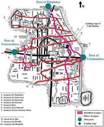
In addition to having a defensive aspect, bridges had uses and implications in the daily life of the islanders in peacetime. The Cabrerra Stampa map (Figure 6) allows me to highlight many bridges within the capital, all located on the route of the main roadways and the crossing of the main lake traffic channels. The land roads were less numerous than the lake roads. The location and distribution of the main bridges are therefore particularly important, as they autonomously fragment the urban space. According to Backouche (Reference Backouche and Fourcaut1996:53–55), bridges have more than just an economic function because they are the only structures that can generate new distribution areas outside a centralized administrative framework, unlike ports and marketplaces.
Transition and coordination areas of Tenochtitlan highlighting the omnipresence of waterways whose location and distribution materialized the fragmentation of the urban space from the island's shores to its center. (Biar Reference Biar2018:180).

Historical works from the beginning of the twentieth century, such as those of Marroquí (Reference Marroquí1900), indicate that the names of the bridges or the streets are associated either with a type of merchandise or with a more complex coordination area. The names given to the bridges and streets support Backouche's (Reference Backouche and Fourcaut1996:53) hypothesis that, due to the lack of space within the city, bridges are the materialization of specific distribution areas for the coexistence of different types of goods in the same port. This hypothesis seems plausible since all the main and secondary ports of Tenochtitlan were located on the banks outside the city and the transit zones inside were under great pressure. Modern examples are the Calle del Puente de la Aduana Vieja (Marroquí Reference Marroquí1900:vol. 1, p. 186), the Calle del Puente and the Calzada de San Antonio Abad (Marroquí Reference Marroquí1900:vol. 1, p. 428), and the Calle del Puente de la Leña (Marroquí Reference Marroquí1900:vol. 3, p. 108). It seems plausible that in pre-Hispanic times bridges would have been also named for their commercial function, either in relation to a type of merchandise or in relation to a religious or political administration.
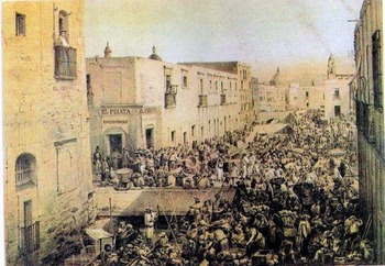
Bridges were therefore landmarks in the organization of lake traffic and created a specialized consumption or transaction area that articulated the exchanges in their zone of influence, thus ensuring the connection between several territories on a large scale. As Marroquí (Reference Marroquí1900) points out directly and Sierra (Reference Sierra1984) points out indirectly, the drying up of navigation channels since the eighteenth century has led to the disappearance of bridges, leading to a transformation in the organization of the surrounding areas of influence toward a redesign of traffic networks to ensure the best possible connection with the new trade routes. Bridges are essential in the organization of the urban grid as unsuspected coordination areas. These facilities deserve to be the subject of future research. Bridges were an identity element of the island nature of the pre-Hispanic capital that continued into colonial times and up to today. The Alhóndiga Bridge, located a few meters from Mexico City's Zócalo, on the old route of the Canal de la Viga and accessible from the Acequia Real (now Corregidora), bears witness to the past links to the final landing stage of Roldán street (Figure 7).
Loading pier of the Calle Roldán, showing the intensity and continuity of traffic between land and water. Boats in the foreground represent lake transport, and a bridge at the back represents land transport. Image from Casimiro Castro and J. Campillo 1864.

WATERWAYS HIERARCHY
Roads, whether aquatic or land-based, are the only tangible evidence of a structural organization of the lacustrine area in the Basin of Mexico (Trombold Reference Trombold1991:1). They reflect insularity, from a material point of view, determined by a transport system that has both advantages and limitations (Hassig Reference Hassig and Trombold1991:18). The summary presented above of previous identifications of different lacustrine facilities in Tenochtitlan reveals that the waterways the Aztecs designed were real structural elements, at the heart of the city's spatial organization. From these results, we can define two major types of waterways: formal and informal.
Formal roads are those that reflect spatial planning in a territory conditioned by particular geographical characteristics and whose construction intention comes from a central power. They have three characteristics in the terrestrial environment. First, a marked alignment that overcomes minor topographical obstacles such as hills or watercourses, reflecting land use planning on the part of a centralized and hierarchical power. Second, a definable width with little variation in dimensions. This can be measured by analyzing architectural remains, such as pavements, embankments, ditches, gutters, or retaining walls. Third, a lack of deviation or random branching which favors control of the nature of the transport (economic, military, religious) and the intensity of the traffic it carries. These characteristics have been widely documented on such archaeological sites as Teotihuacan (Charlton Reference Charlton1978; Millon Reference Millon1973, Reference Millon and Berlo1992; Sanders Reference Sanders1965) and Xochicalco (Hirth Reference Hirth1978, Reference Hirth1982, Reference Hirth and Trombold1991, Reference Hirth1998). The implementation of a land or water transport system entails the execution of numerous engineering works that involve the entire social hierarchy, as well as all available resources. The operation of such projects depends on the ability of a political apparatus to gather, supply, and maintain a large supply of labor and construction materials.
Informal roads are roads of necessity. They do not present any particular type of planning or maintenance, as their primary function is to link together different sites. These roads are designed according to the needs of their users, who, through their repeated passages, end up marking the landscape. This would imply that the changing needs of the societies that use them could lead them either to disappear, without leaving any archaeologically visible traces on the territory, or to be reused or even partially transformed into a formal road. From a linear point of view, an informal road adapts completely to the topography of the territory it crosses. It will constantly bypass rugged natural areas and systematically bend to geographical constraints. All these characteristics can sometimes make these roads dangerous, even impassable, depending on the season. Very often, they are passable in only one direction at a time. If informal roads exist in a lacustrine environment, the hazards related to topography will be of a completely different nature.
Formal Routes: Acequias
Adapted to the urban area of the Aztec capital, two types of waterways will be identified: the acequias as formal routes and the canals as informal routes (Calnek Reference Calnek1972:109; González Aragón Reference González Aragón1993:44; Lombardo de Ruíz Reference Lombardo de Ruíz1973:115). The former are wide and easily accessible by water and land which used to support an intense shipping traffic linked to port facilities, various loading piers, and at least one of the four main causeways. The latter are auxiliary waterways of varying width that connected inner residential units or suburban residential chinampas (Morehart and Frederick Reference Morehart and Frederick2014) associated with communal piers or domestic landing stages. These two types of routes formed a dense and complex, harmonious network within the capital to meet the needs of both the elites and the non-elite residents by interconnecting the imperial economy to the city economy.
The acequias, identified here as major axes, structured the urban space in the same way as the pedestrian causeways did. They are clearly mentioned by many authors (eg., Cuevas Aguirre et al. [Reference Cuevas Aguirre y Espinosa and de Huemez y Horcasitas1905], Favila Vásquez [Reference Favila Vásquez2011], González Rúl et al. [Reference Rúl, Francisco, Palacios and Hernández1996], Hernández Pons [Reference Hernández Pons2002], Lombardo de Ruíz [Reference Lombardo de Ruíz1973], Marroquí [Reference Marroquí1900], Sierra [Reference Sierra1984]). They are also mentioned in archival documents, mainly from the Ríos y Acequias branch of the General Archives of the Nation (AGN) and the General Historical Archives of the Federal District (AHGDF) of Mexico City. Through my research, I have identified ten of them, of which seven are oriented east–west and three are oriented north–south (Figure 7). Due to the disappearance of their pre-Hispanic names, I will use their colonial names for convenience, including excerpts from the works of González Rúl et al. (Reference Rúl, Francisco, Palacios and Hernández1996), Hernández Pons (Reference Hernández Pons2002), Lombardo de Ruíz (Reference Lombardo de Ruíz1973), Marroquí (Reference Marroquí1900), and Sierra (Reference Sierra1984). It should be remembered, however, that the names of the acequias, until their destruction in the nineteenth century, will have evolved according to the evolution of the urban fabric of the capital. During the colonial period, they were named after a building (church, bridge, palace, square, market) or after a real person or a saint (Monzón, San Antonio Abad, etc.). In addition, the same acequia could have several names because it was divided into different sections—between two bridges, for example. The present work will focus on their urban importance in pre-Hispanic times rather than on their evolution and naming. The majority of the acequias were reused under Spanish rule, not only to maintain part of the lake traffic linked to the supply of the city, but to facilitate the desagüe, referring to the drainage projects of the lakes of the Basin since the seventeenth century (Hernández Pons Reference Hernández Pons2002:93). Indeed, the primary function of these formal aquatic roads was to protect Tenochtitlan from flooding, since they channeled the lake currents and, in coordination with the dikes and roadways, made it possible to control the fluctuation of the water level (Lugo Ramírez Reference Lugo Ramírez2007:39). Seven of these acequias, still in use in 1637, were documented by Manuel Payno in his work on the Desagüe de México (in Sierra Reference Sierra1984:22), which helps us to evaluate their dimensions. To date, only two of them have been the subject of archaeological excavations that are able to provide us with scientific and material data. These are the Acequia Real (Hernández Pons Reference Hernández Pons2002; Jiménez Vaca Reference Jiménez Vaca2013; Siller and Rodríguez Díez Reference Siller and Rodríguez Díez1983) and the Acequia de la Merced (Lugo Ramírez Reference Lugo Ramírez2007).
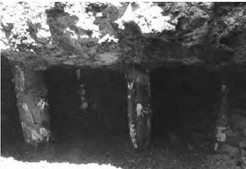
Acequia de La Merced, showing its construction on stilts (Lugo Ramírez Reference Lugo Ramírez2007).

The Acequia Real
The Acequia Real was one of the most critical shipping routes that crossed the capital from east to west. It was the only waterway that gave a direct access to the heart of the island of Tenochtitlan's navigation, allowing access to the Recinto Sagrado and the houses of the Emperor Moctezuma. It was excavated on a 260 m long route that started at the foot of the current Palacio Nacional (formerly the Palace of Cortés), located northeast of the current Plaza del Zócalo. It followed the present Corregidora Street until it crossed with Roldán and Alhóndiga Streets. It has all the characteristics of a formal road. First of all, it presents a marked alignment and has a substantially constant width. This is estimated by Jiménez Vaca (Reference Jiménez Vaca2013:5) at six meters. Hernández Pons (Reference Hernández Pons2002:78) estimates the portion dedicated to navigation at three meters. Its depth varies between 2.60 m and 3.80 m. In some places (Cala 7), the construction system of the walls of the acequia involved the use of piles, some inside the walls, others outside. According to Hernández Pons (Reference Hernández Pons2002:73), the latter were intended to protect the walls from repeated impacts by boats and to facilitate their mooring. The excavations also uncovered evidence of a shipwreck (Hernández Pons Reference Hernández Pons2002:63–74), numerous deposits of artifacts (mainly ceramics) probably having a ritual function (Hernández Pons Reference Hernández Pons2002:75), and a structure identified as a private pier associated with the emperor's palace (Corona Reference Corona1994; Hernández Pons Reference Hernández Pons2002:65). In addition to this are a number of corollary discoveries related to navigation on this acequia, among which are the carved monoliths, such as the Piedra del Sol, and the Coatlicue (Mateos Higuera Reference Mateos Higuera and Matos Moctezuma1979:274–275). According to my hypothesis on the lake transport of these monoliths (Biar Reference Biar2018:161), the Acequia Real was the road used to transport them to the Recinto Sagrado. If we assume that other sculpted monoliths, such as the Coyolxauhqui disc or the Tlaltecuhtli monolith, both found at the Templo Mayor site (López Austin and López Luján Reference López Austin and Luján2010:36; Matos Moctezuma and López Luján Reference Matos Moctezuma and Luján2012), were also transported along the Acequia Real (something that cannot be proven), the width of the acequia can be defined, for the pre-Hispanic period, from the dimensions of these monumental sculptures. In this case, the width estimate given by Jiménez Vaca (Reference Jiménez Vaca2013) seems more probable than that of Hernández Pons (Reference Hernández Pons2002). This hypothesis is also supported by González Rúl (Reference González Rúl1998:40), who estimates that the main canals of Tenochtitlan must have been between three and seven meters wide and between two and three meters deep. Thus, in addition to its proximity to the buildings of power, this formal route would support the traffic in prestigious goods for the elite.
The Acequia de La Merced
The Acequia de La Merced, one of the longest formal waterways in the Aztec capital, is one of the best documented from an ethnohistorical point of view (Cuevas Aguirre Reference Cuevas Aguirre1979; Marroquí Reference Marroquí1900; Sierra Reference Sierra1984) and can be considered the food artery of Tenochtitlan. According to Lugo Ramírez (Reference Lugo Ramírez2007:37), it could be that this lacustrine route dates at least from the end of the reign of Huitzilihuitl (r. 1396–1417) and the beginning of the reign of Chimalpopoca (r. 1417–1426). At that time, the majority of the islands and islets in the lagoon were populated by Aztec communities that began to expand through the chinampas system (González Rúl Reference González Rúl1998:17–18). The design of its trajectory, from east to west, would have corresponded to one of the currents of the lake that circulated between the different islets, which would have allowed it to be channeled and thus avoid flooding. Archaeologically, this design is manifested in pre-Hispanic containment walls formed by a palisade of wooden piles, very well preserved, slightly inclined in order to retain the soil of the artificial islet (Lugo Ramírez Reference Lugo Ramírez2007). For the colonial period, the archaeologist Lugo Ramírez (Reference Lugo Ramírez2007:40) identified a masonry wall resting on the piles driven into the lake bottom (Figure 8). Lugo Ramírez notes that the lower part of these piles was pointed for better insertion into the lake floor, while the upper part was rounded; each of them had a maximum thickness of between 7 and 10 cm; and between the pre-Hispanic pilings and the colonial-era masonry wall, the width of the acequia was slightly more than 4 m (Lugo Ramírez Reference Lugo Ramírez2007:40). Its location to the south of the Acequia Real and its connection with two other “economic poles”—namely, the Canal de la Viga and the market of La Merced—suggests that this acequia was used for a local economy, an economy of redistribution, whereby merchants probably moved from house to house using watercrafts (Biar Reference Biar2018:190). As for the ethnohistorical data, they inform us that the course of at least these two formal waterways would correspond to the trajectory of natural currents that have been channeled (Lugo Ramírez Reference Lugo Ramírez2007).
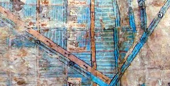
Pictographic representation of the hierarchy of the waterways in a chinampera area, where three types of canals can be identified by the stylistic design. Image by Sylvie Elies based on a detail of the Plano en Papel de Maguey. Fototeca INAH.

Informal Routes: Canals
Meanwhile, the canals were transport waterways of less hierarchical importance because their operation would be intimately linked to their connections with the acequias. Based on the work of Earle (Reference Earle and Trombold1991) and on iconographic documents, such as the Plano en Papel de Maguey or the Codex Reese, the functioning of these canals can be understood in the absence of archaeological data. These waterways should be studied according to the level of social organization of those using them, as it is this social level that will define their physical characteristics. A family canal was to be used by a small number of people for a small volume of transport, having no other function than to link together family units. A community canal would be the product of intensive use and not of real planning work; it would connect family units to central waterways to gain access to local economic (market), religious (temple), and political (administration) centers. Thus, the central or seigneurial canals would be directly linked to the formal roads and be the responsibility of the local elite. All three types of canals would play a role in the transition of passengers, goods, and merchandise from the family level to the capital. Their distribution and articulation would reflect a geographical reality of the lacustrine cultural landscape of Tenochtitlan (Biar Reference Biar2020) in its urban context (Castañeda de la Paz Reference Castañeda de la Paz2011).
The Plano en Papel de Maguey is a register of properties dated 1558, representing a residential area of Tenochtitlan. More than 400 residential sites, delimited by chinampas, are reported, the majority of which are accessible only by water (Calnek Reference Calnek1973:109). The number of canals represented is relevant and allowed González Aragón (Reference González Aragón1993:44) to differentiate the canals by their size and the conventions of pictographic representation. The central canal can be identified by its width and its turquoise blue color on which the water glyph is represented in black (Figure 10). Wave patterns emanating from this canal suggest a certain movement of the water, perhaps that of a current. Parallel to the canal, the causeway, identified as that of Tepeyacac, is represented by footprints that leave no doubt as to its land use. These two roads are framed by a black line that both delimits and combines them, allowing direct access to the center of Tenochtitlan: the roadway by land and the canal by water. From this pictographic convention, I deduce that these two types of roadways have equal importance, especially when they are of the same width. However, I do not believe that this is relevant in assessing the actual width of these communication routes. Note that this road is at the center of the cartographic design and that it provides access to the majority of community and then family channels. The community canals are narrower, always painted blue, with a simplified water glyph, and framed by a black outline with a less dynamic wave representation. This difference in representation may be a translation of the traffic intensity. Noted above is that one of the characteristics of informal routes could be non-alignment, in order to adapt to environmental constraints. In this particular case, the informal roads or secondary canals all present a perfect alignment. This may relate to the implementation of the chinampas, which is specific to the urban context of Tenochtitlan. Organized on a particularly precise alignment, these artificial islands form straight informal roads.
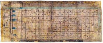
An official colonial document from Codex Reese, showing the importance of a formal canal in the upper part as a structural element of the cadaster. Image by Sylvie Elies based on the Digital Collections at the Beinecke Library collection, brbl-dl.library.yale.edu/collections/highlights/codex-reese.

This alignment can also be seen in the Reese Codex. Also known as the Beinecke Map, this codex was probably made in the aftermath of the Conquest, in the 1560s. Identified as a cadaster of agricultural properties under colonial jurisdiction, it is argued to represent an area of the island town, formed by 121 plots of land on which the names of their owners are mentioned (Mundy and Miller Reference Mundy and Miller2012:9). This peculiarity is due to its use as a legal support in claims of landownership, opposing indigenous and Spanish people (Mundy and Miller Reference Mundy and Miller2012:3). However, without a toponym, it is difficult to pinpoint its exact geographical location. The interest of this document lies in the representation of a lacustrine road shown in the upper part of the map. Referring to the pictographic representations of the lake routes defined by González Aragón (Reference González Aragón1993) in his study of the Plano en Papel de Maguey, I argue that there would seem to be a similarity with those represented here. The lake road shown here could be identified as a central canal because of its width and turquoise blue color on which the water glyph is represented in black (Biar Reference Biar2018:195). This lake road structures and frames half of the map, again giving it a prominent role in the perception of the lacustrine cultural landscape.
DISCUSSION
Each of these waterways has particular characteristics that can be observed both archaeologically and ethnohistorically. Fueled by new discoveries, this reflection will help to understand them with more accuracy.
The anthropic markers that mark the water and land routes of Tenochtitlan appear as significant elements in the design of its lakeside cultural landscape. Being true markers of continuity, they materialize in a more or less elaborate way the main axes of communication and exchange. By creating a fluidity of circulation, they determine the nature of this island territory and participate in its reality. I hope that the systematic identification of landing stages, ports, customs facilities, warehouses, and bridges will help researchers to materialize the Mexica spatial conception within the Basin of Mexico as a social process of appropriation of this lacustrine space and thereby make it easier for archaeologists to know what to look for and where to look for it.
All these facilities seem to be very hierarchical to ensure the control of traffic and goods entering and leaving the island capital. Extending this reflection beyond the urban context of Tenochtitlan would allow us to deepen our knowledge of the design and operation of lakeside traffic set up by the Aztecs throughout the Basin of Mexico.
Excavation techniques adapted to wetlands can identify these structures, allowing them to be preserved and analyzed. Artifacts made of perishable materials, such as wood, are sometimes preserved, as has been shown by Parsons and Morett (Reference Parsons and Morett2004), following the discovery of a smaller lake infrastructure in 2003 at the northeastern end of a small, existing lagoon that belonged to Texcoco Lake. They identified this site, which they named Localidad 210, as a place of ritual offering. They discovered numerous traces of wooden poles, some of which were still embedded in the lake floor, on a north–south alignment. This lacustrine structure measured approximately 1.5 × 1.3 meters (Parsons and Morett Reference Parsons and Morett2004:42). In the vicinity of this structure, the archaeologists unearthed many pre-Hispanic artifacts: censers, an anthropomorphic green stone figurine, and lithic material in basalt and obsidian. The presence of palafitte ceramics belonging to the Aztec III type allowed them to date these remains to the second half of the fifteenth century. According to Parsons and Morett (Reference Parsons and Morett2004:41), this offering must have been located close to some kind of seasonal camp and was linked to the riparian communities that would exploit the lake's resources.
Another example was found in 2015, as part of the construction of a new Mexico City airport (a project eventually abandoned in 2018), by the team from Salvamento Arqueológico of the Institute of Anthropology and Mexican History, led by archaeologist Rodríguez Barrera (Reference Rodríguez Barrera2016). They discovered and explored an area located in the immediate vicinity of the city's historic center and made up of 30 “floating gardens” (chinampas), which were used in Aztec times. This discovery is fundamental in that it marks a transition from the study of historical descriptions to the study, in situ, of archaeological developments related to the lakeside life of ancient Tenochtitlan. Located in one of Tenochtitlan's former marshy areas, this 4.5 ha open-air site is now in the Transito (colonia) district, 2 km south of the Templo Mayor archaeological site. According to historical sources, mainly from the sixteenth century, this site, now identified as Ateponazco, belonged to the extreme southwestern district of ancient Mexico–Tenochtitlan, described as a farming area with numerous chinampas. Archaeologists have identified about 30 of these artificial plots of land, approximately 30 meters long and 2 to 8 m wide. It would appear that all except for one plot, which had a residential wall, were used for production aimed at the self-sufficiency of the inhabitants of the neighborhood. These chinampas were partly bounded by one of the great waterways that linked the south of the Basin to the metropolis, as far as the edge of the sacred enclosure (Recinto Sagrado). They were separated by small canals mainly used for irrigation. In addition to this exceptional discovery, 16 offerings dedicated to agrarian deities, the god of the wind, Ehecatl-Quetzalcoatl, and the god of corn, Chicomecoatl, have been unearthed, involving more than six hundred intact objects, such as figurines and Aztec ceramics, perfectly preserved. This practice of domestic rituals is considered by its discoverer to be associated with the blessing of the chinampas before their cultivation to ensure the protection of the gods. However, it would seem that this site was abandoned rather quickly, less than fifty years after the fall of Tenochtitlan, mainly due to the urban reorganization imposed by the Conquistadors (Sánchez Nava Reference Sánchez Nava1984).
Even though the Basin of Mexico, and more specifically Mexico City, are highly urbanized both above ground and below, some archaeological material traces remain. Coordination zones, particularly those corresponding to loading docks, will be the most numerous and the most readily identifiable due to their reuse by early colonial urbanization, as has already been demonstrated by previous excavations (González Rúl Reference González Rúl1998; González Rúl et al. Reference Rúl, Francisco, Palacios and Hernández1996; Hernández Pons Reference Hernández Pons2002; Sánchez Nava Reference Sánchez Nava1984). Precisely defining the layout of the various circulation channels, or acequias, would increase the chances of discovering other material remains of the nautical past of Tenochtitlan, including the precise location of the port facilities, as defined here. Finally, a systematic archaeological survey of the lacustrine area that survives to this day in Xochimilco, combined with an ethnographic study of the few people who still live on these canals, could clarify both the hierarchy of transport waterways and the social organization of a lacustrine territory.
CONCLUSION
Through this article, I hope to have demonstrated that the urban territory of Tenochtitlan is the result of a collective socialization of the lacustrine space, where the territory, marked by specific nautical installations, becomes a support for identity and cultural formation that contributed to the specific character of this lacustrine culture.
The insular location of this capital city resulted in two identifiable types of lake routes, channeled by the urban grid and imperial, community, and family economic needs. These roads, identifiable through anthropic markers, attest to a continuity of the road network between two environments, aquatic and terrestrial. The navigation and facilities of Tenochtitlan were designed to support, above all, an economy based on intense and voluminous transport, administered mainly by means of waterways, in which navigation routes and facilities were designed for optimum use of the boats and their carrying capacity.
I hope that these novel reflections have disrupted the predominantly terrestrial vision that we have of the Mexican economy, inviting us to rethink the dynamics of distribution within the lagoon of Tenonchtitlan and the entire lake system of the Basin of Mexico.
RESUMEN
La naturaleza insular de la capital azteca, Tenochtitlan, es un aspecto poco estudiado en nuestra comprensión de este espacio urbano único, situado en las tierras altas mexicanas de Mesoamérica. La ubicación de la isla induce a cruzar los caminos acuáticos y terrestres para crear conectividad y continuidad dentro del paisaje cultural lacustre de la Cuenca de México durante el período Posclásico (900–1521 d.C.). Aunque Cortés describió esta ciudad como la “Venecia del Nuevo Mundo,” no se ha realizado ninguna investigación específica y sistemática de las instalaciones relacionadas con el transporte de agua. En el presente artículo colmo esta laguna mediante el estudio de las rutas de navegación que fueron concebidas para facilitar el continuo movimiento de personas y mercancías a través de los numerosos canales que atraviesan la capital azteca, y que son identificables por medio de marcadores antrópicos que responden a necesidades funcionales. Las zonas de transición (embarcaderos, muelles, zonas costeras), las zonas de coordinación (puertos) y las zonas de actividad (instalaciones aduaneras, almacenes, puentes, lugares sagrados) están todas ellas relacionadas con la práctica del transporte por agua e íntimamente ligadas a los caminos terrestres. Identifico y localizo esas zonas utilizando una metodología multidisciplinaria basada en datos arqueológicos, testimonios etnohistóricos y documentos pictográficos e iconográficos.
ACKNOWLEDGMENTS
I would like to thank the ArchAm laboratory for its academic and economic support throughout my Ph.D., the Mexican External Relations Service for its financial support at the beginning of my thesis, and all my Mexican colleagues at the Instituto Nacional de Antropología e Historia for their precious advice during my research stays in Mexico City.