


The metropolis of London grew in population rapidly during the early modern period so that by 1700, it was the largest city in Europe.Footnote 1 During this period, the city's water was increasingly supplied by a number of private companies. Among these, the London Bridge Waterworks (LBWW) was the oldest and one of the most important. It existed from 1581 until 1822, when the medieval London Bridge was finally replaced and the company was bought out by the New River Company. The LBWW was the largest company from its foundation until the New River Company overtook it some time in the seventeenth century. From that point, it remained the second largest until the metropolis’ growth allowed other companies with access to the expanding suburbs to pass it early in the nineteenth century.Footnote 2 The LBWW was, therefore, one of the pre-eminent companies operating within the city. The largest businesses located in the city, such as the East India Company, were in sectors such as finance, insurance, manufacturing and trade. The water companies, however, were some of the largest companies to focus exclusively on the city itself. By the eighteenth century, they served tens of thousands of houses, meaning they were deeply involved within the domestic and commercial life of London's inhabitants. From the point of view of the number of customers, they were as extensive as other large business, such as the fire insurance companies of the eighteenth century.Footnote 3
This article provides a history of the LBWW with a particular focus on the mid-eighteenth century. It has two main aims. The first is to show that the LBWW's history as a water company was especially linked to London Bridge where it was located. Indeed, the bridge's very existence made the LBWW possible because it provided the best vantage point to harness the Thames’ flow to supply water to London. The size of the bridge made the LBWW's expansion over time possible, but also placed limits on that expansion. Ultimately, the LBWW's demise followed necessarily from the bridge's own deterioration and replacement. It was not, however, only in terms of physical access to water and London that the LBWW's history was shaped by its position on the bridge. Because the bridge was the property of the City of London, this meant that the company was particularly dependent on the City Corporation during its entire history, and especially when changes required the City Corporation's approval. The City of London was the central part of the metropolis, located largely within the old medieval walls, and was governed by a municipal corporation. Fortunately for the LBWW, the City Corporation proved to be quite generous towards it, originally leasing space on the bridge for nominal sums and even providing loans. These easy terms were maintained throughout the LBWW's history. There were further consequences of the LBWW's place on the bridge. Namely, most of the LBWW's customers were in the City itself, with very few beyond its boundaries in the ever expanding suburbs. However much the LBWW may have wanted to take on more customers, it simply could not expand its pumping capacity beyond the limits the bridge imposed. This limitation of its customer base to the City meant that the LBWW's history mirrored some of the dynamics of the City within the broader metropolis. The growth of the New River and other companies such as the Chelsea came with the expansion of the suburbs, while the LBWW was locked to the City. As the City became more commercial and less residential towards the end of the eighteenth century, it marked the decline of the LBWW itself as it simply could not find the customers to keep up with the other companies. The LBWW, more than any other water company in the metropolis, was closely tied to the City because of its place on London Bridge.
The article's second aim is to describe the LBWW's technology in the mid-eighteenth century when it was at its peak in order to show how the LBWW ran a significant part of London's water supply. The LBWW's technology was important because together with the New River, the LBWW was at the forefront of the development of water supply infrastructure in Europe in the eighteenth century. When the LBWW was first founded, London's water infrastructure of conduits and wells was similar to that found in other cities.Footnote 4 The LBWW itself was made possible by new waterwheels and pumping mechanisms that originated in Germany.Footnote 5 By the eighteenth century, however, the London water companies developed an ability to supply thousands of houses, a feat that far surpassed continental infrastructure. In the nineteenth century, this achievement was explicitly used as a model for water infrastructure built in other cities.Footnote 6 Understanding how the LBWW was built and maintained in the eighteenth century, therefore, provides an insight into the broader evolution of large-scale water supply networks. A great deal of information is available about the LBWW because in 1745 its surveyor and secretary, Samuel Hearne, wrote an extensive engineering report for the company's directors that described the state of its works in extensive detail, from its great waterwheels down to the location of all its valves in the city's streets. This description is unique in the archives of the London water companies before 1800 for its scope. While substantial material from water companies exists from before 1800, none provides such a sense of how a water company operated in the eighteenth century. Even the records of the New River Company, about which a great deal more has been published, do not contain a technical description of such detail from this time.
The origins of the London Bridge Waterworks
The LBWW was the first of London's water companies. Before the LBWW, London's water supply came from wells, rivers and conduits, which were public fountains fed through lead aqueducts. The LBWW introduced a commercial element to water supply, and new companies were formed soon thereafter, the most important of which was the New River Company. It received a royal charter in 1619, about 10 years after it was formed. The New River drew water from sources to the north of the City to reservoirs near Islington via an aqueduct. It distributed water into the western reaches of the City, and to the areas to the west of the City into Westminster. The third largest company in the eighteenth century was the Chelsea Waterworks, incorporated in 1722. The Chelsea supplied Westminster and other areas to the west of the City. All these companies signed contracts with customers and supplied water directly to buildings through pipes. The water was delivered to a given house for a few hours per day on a few days per week. Despite the availability of piped water, many buildings continued to rely on wells and other sources well into the nineteenth century.
The LBWW was built on the medieval London Bridge, which was situated near the east end of the City (Figure 1). The bridge was a central part of the life of the city from the time it was built in the twelfth century, replacing an older structure. It was the sole road link to the south side of the Thames until the opening of Putney Bridge in 1729. Like other medieval bridges, many shops and houses were located along its length until most were cleared away after 1760 to make more room for traffic.Footnote 7 The waterworks buildings were first constructed on the bridge in 1582 by Peter Morris. Not much is known about Morris, but he was an engineer of either Dutch or German background who had arrived from the Continent some time before 1572. Morris brought with him knowledge of the waterwheels that had been erected in German cities, such as Hamburg, to provide municipal water supplies.Footnote 8 In 1578, Morris secured a patent from Elizabeth I for an improved water pump, provided he should implement it within three years.Footnote 9 As a result, in 1581 he agreed with the City, which was keen to improve water supply, to install a mechanism.Footnote 10 At the time, London was experiencing rapid growth, and its existing infrastructure of wells and conduits was proving inadequate. Morris leased the first arch of London Bridge from the City so that he could build a water-driven pump mechanism. The City's interest in the project was reflected in the generosity of the lease: it ran for 500 years at 10s per year, with Morris keeping all profits from selling water. Construction began in 1582, and he soon leased on the same terms the second arch of the bridge where the stronger water current provided more force for driving a waterwheel.Footnote 11
A view of London Bridge in 1720. The waterworks are on the left. From J. Stow and J. Strype, A Survey of the Cities of London and Westminster: Containing the Original, Antiquity, Increase, Modern Estate and Government of those Cities, 2 vols. (London, 1720). Courtesy of London Metropolitan Archives, City of London.

The LBWW struggled initially and survived only with further largess from the City. It gave Morris financial support in the form of various loans amounting to around £1,400.Footnote 12 After this shaky start, the business found sufficiently solid footing that it did not require further monetary support from the City. Morris’ family inherited the company, eventually restructuring it into a trust in 1659.Footnote 13 Despite the LBWW's works on the bridge burning down in a fire in 1633,Footnote 14 the company was generating over £1,000 in profit per year for the Morris clan by the 1660s.Footnote 15 The works were destroyed once again in the Great Fire of London in 1666, an event that led to acrimonious divisions within the Morris family. On one hand, Mary Morris, the widow of one of Peter's grandchildren, wanted to rebuild the works quickly. On the other, Thomas, her brother-in-law, opposed it in an attempt to deprive her of the income for unknown reasons. The matter ended before the courts and the works were finally rebuilt in 1668.Footnote 16 In the meantime, the LBWW's chief competitor, the New River, was not harmed by the conflagration, and opportunistically poached many of the LBWW's customers in the fire's aftermath. In response, the owners of the LBWW unsuccessfully petitioned the privy council to have a royal decree issued forcing the New River back to its original area.Footnote 17
A major reorganization of the LBWW took place after 1700 that enabled the company's works to grow supported by new investment. It also saw the company leave the Morris family's control, prompted in part by important developments in the City's financial industry. From 1685, a joint-stock boom was driving the creation and incorporation of many new companies, with investors seeking new opportunities.Footnote 18 The LBWW proved a tempting target because the pressure that the New River was putting on it had not relented, and the family decided to sell out.Footnote 19 They partnered with a group of investors headed by Richard Soame, who had approached them about buying the works for £36,000.Footnote 20 Rather than selling immediately, however, Soame and his backers convinced the head of the Morris family at that time, Thomas Morris, to join with them in a complicated scheme. It involved persuading the City of London to lease yet another arch to the LBWW (the fourth from the north end) to allow for greater water pumping capacity.Footnote 21 As part of the deal, Morris had agreed to lower the annual charge for water to 20s per house, and not to allow the lease to fall into the hands of the New River Company.Footnote 22 The deal was complicated by two further transactions. In one, a small waterworks at Broken Wharf that supplied water via horse pumps was purchased and merged with the LBWW.Footnote 23 In the other, some of Soame's group contracted to lease a number of the City's other water sources, notably some conduit springs. The City agreed to the two transactions it was party to (the new arch and the conduits) on the understanding that they were effectively one, and so when the Soame group tried to back out of the conduit lease, the City stalled signing the bridge lease. The matter ended in lawsuits between the City, the new water partners and Thomas Morris, before finally ending in the bankruptcy of some of the partners.Footnote 24 The LBWW itself became an unincorporated joint-stock company with 1,500 shares worth £100 each.Footnote 25 The conduits portion of the company was cast aside. Being an unincorporated company at this time was not unusual, and it meant that there was no explicit recognition of the legal personality of the business.Footnote 26
The change of ownership led to new investment that proved to be important for the further elaboration of the LBWW's technology. Up to this point, the capital available to improve its works was limited to the Morris family’s. Following the reorganization, the LBWW's new shareholders were more willing to put money into it to capitalize on demand. At first, they hired George Sorcold, a well-known English water engineer, to build a new pumping mechanism under the fourth arch in 1702.Footnote 27 At this time, the LBWW was approximately a third the size of the New River, based on the number of employees it needed to maintain its works and to collect fees.Footnote 28 Even this new capacity proved to be inadequate to meet demand, and the LBWW in 1731 asked the City to lease the third arch of the bridge between ones where it already had waterwheels. The City, however, declined.Footnote 29 Evidently, the support the City was willing to provide in the 1580s, and even in 1700 through generous leases, had evaporated, probably because so many more water companies had been formed. For its part, the LBWW consolidated its position in 1738 when it came to an understanding with the New River Company whereby the two agreed not take customers from one another.Footnote 30
The LBWW in 1745
It was in this situation that Samuel Hearne described the LBWW in 1745. Hearne had originally come to the LBWW perhaps as a collector, but later became the secretary. In 1739, he was appointed the surveyor, a post he felt a reluctance to take because of ‘the little knowledge I was sensible I had in the mechanics both in theory and practice’.Footnote 31 Likely due to this sense of unease, he set himself the task of describing the entirety of the works. With his other duties still pressing, it took him until 1745 to produce the report. The report was roughly divided into four parts each describing one aspect of the works: the pumping mechanisms; the water tower; the pipe network; and the employees and operations.
The engines
The pumping mechanisms raised the water that allowed the LBWW to serve its thousands of customers, and their combined capacity had been greatly enhanced between 1700 and 1740 with additions and reconstructions. They were located within the three arches, and consisted of 5 waterwheels driving 16 pumps. The wheels turned in the flow, but since the tides affected the river flow strongly, their speed varied according to the time of day, and even stopped for 45 minutes when the tides were turning, shutting the water supply completely. It was at these still moments that the company's employees cleaned and repaired the wheels. Originally, these periods were accepted as simply part of the nature of the waterworks. When competition with other companies arose, however, they became a limitation imposed on the company by the bridge and the tidal Thames. The mechanisms under the first two arches had been made of wood from their first construction in 1582 up to 1700. It was this pumping technology that Morris had introduced from the Continent. After the reorganization, more money was put into rebuilding the mechanism, and more components such as the cranks and cylinders were made of cast iron.Footnote 32 This allowed their motion to be more regular. The slow increase in the manufacture of iron goods through the late seventeenth and eighteenth centuries had made these sorts of components more readily available.Footnote 33
The waterwheel in the first arch (called the ‘two ring wheel’) was rebuilt in 1728, when the channel through it was deepened to try to increase the flow. Unfortunately, there was a sewer emptying into the Thames immediately above the bridge, sending foul water through the wheel and into the pumps. At low tide, the water was so ‘muddy’ that the wheel was not used lest the filth jam the valves and pistons. The pistons did not draw water directly under this arch. Rather, a well was dug into the starling (arch pier). Water from the second arch was passed into this well through a pipe, and the suction pipes inserted into it. The functioning of this wheel and pump mechanism was described by Henry Beighton in 1731 (Figure 2).Footnote 34
The waterwheel in the first arch. H. Beighton, ‘A description of the water-works at London-Bridge, explaining the draught of tab. I.’, Philosophical Transactions of the Royal Society of London, 37 (1731), 5–12.

The waterwheel (the ‘three ring wheel’) within the second arch had been rebuilt in 1732, replacing one installed in 1717 to increase the water pumped from this arch. In 1717, the lock had been widened and deepened, and one large wheel had replaced two much smaller ones. These used to drive only three pumping engines between them at a slow rate, while the newer wheel drove four. The current through this arch was much greater than the first, and the lock deeper and wider, so that the quantity of water it pumped was proportionately greater.Footnote 35
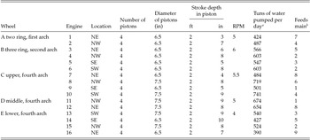
The fourth arch, added to the LBWW after 1700, had the largest mechanism within it, including three waterwheels and ten pistons. The addition of this mechanism at that time had represented a significant step up in capacity. In 1745, the fourth arch wheels pumped 64 per cent of the LBWW's water (Table 1). The first wheel in the water current (the ‘upper wheel’), was located on the bridge's west side and was the largest of all. It had been rebuilt in 1742. At that time, the number of cogs on the wallow wheel (see below) were cut from 25 to 20 as in other wheels at the works in order to reduce the pumping frequency but increase the force. This had decreased the friction in the pistons as well. The LBWW used to receive complaints of poor supply from their turncocks in Fleet Street, which was supplied from this wheel, but since the alterations these had diminished notably.Footnote 36
Summary of the waterwheels taken from Hearne's 1745 report

a 1 tun is about 955 litres.
b See Table 2.
Source: London Metropolitan Archives ACC/2558/MW/C/15/102.
The second wheel in the arch (‘middle wheel’) was rebuilt in 1726 and drove two engines. Unlike the other wheels described so far, this one had been designed to rise and fall with the tides to ensure smoother functioning. It was, however, a case of technological innovation not paying off. Hearne observed that, unfortunately, the mechanism required vigilance to work well, but ‘the watchman is liable to sleep in the nights’ and did his duty poorly. The mechanism was costly to construct and required many repairs to fix defects stemming from the irregular motion of the wheel. Hearne judged that the mechanism brought little benefit.Footnote 37
The final wheel (‘lower wheel’) was the last in the fourth arch. It was large, but less effective than the two upstream wheels. It had been rebuilt in 1734, but was too large, sitting too deep in the water. It was meant to rise with the tide as well, but did so too slowly. The result was that it threw water back into itself, slowing the mechanism as well as the current through the arch, thereby hindering the other two upstream wheels. At low tide, the suction heads were too high in the water, and often drew air into the pipes. This air was then forced into the pipe network, causing serious obstructions and even bursting mains. It cost £400 per year to repair.Footnote 38
Hearne estimated the total volume pumped per day was 8,884 tuns (8.5 megalitres), of which one sixth was lost to wastage in the engines, making the effective net volume delivered to the pipe network in the city to be 7,404 tuns per day (7.1 megalitres), or about a tun per customer (see Table 1). A tun is an antiquated unit of volume, equal to 210 imperial gallons, or about 955 litres. Customers received nowhere near this amount of water because much was wasted, either by the ‘fountaine of water running over the top of thee waterhouse tower into the Thames again’ or by ‘the rivers of water constantly running in the streets occasiond by the overflowing of the inhabitants cesterns where they have noe ball cocks’. In addition, many of the pipes in the streets leaked into sewers and drains.Footnote 39 Hearne thought there were 20–30 leaks in the mains at any given time, either from decay or damage, or human error.Footnote 40 The total loss to waste was no more than one eighth of what was pumped. Despite all this, the supply was generally good. There had been no complaints received in the three months previous to the report.Footnote 41
The basic functioning of the pumping mechanisms in use at the LBWW was that each waterwheel turned a large gear (the spur or cog wheel) attached to its end through a common axis. The spur wheel in turn drove another gear with fewer teeth (the wallow wheel), meaning it rotated more slowly. The wallow wheel then turned a crankshaft, which transformed the rotational motion of the wheels into the up-and-down vertical motion of four rods. The rods drove the pistons in the pumping engine through levers. The pumps were vacuum piston pumps, meaning they raised water on upward stroke through one-way valves. The valves then shut on the downward stroke of the piston, forcing the water out into the pipes leading to the water tower. The piston heads were connected to the cylinders by leather hoses to prevent the water from rushing out in the space between the head and the cylinder. These leather components wore out quickly and needed frequent replacement.Footnote 42
Valves were attached to the pipes leading to the mains, and these allowed the company to drain all the mains slowly during cold weather just when the machines sat idle at low tides. This kept water moving in the pipes and prevented them from freezing. The pipes went both to the mains and to the water tower.Footnote 43
The water tower and the mains
The pipes coming out of the engines led directly to the mains, with all but one main supplied by two different engines to improve reliability. Vent pipes linked to the mains as they passed under the water tower. These vents relieved the pressure in the main if water was not moving along them fast enough, thereby preventing them from bursting in the streets. The vent pipes fed two lead cisterns, one atop the other, at the summit of the water tower, each with a two tun capacity. Further pipes drained these cisterns back into the mains, with the ones that usually had greater problems meeting demand receiving water first. This system in effect transferred water from mains that had too much supply from the engines to those that required more. If the cisterns overflowed, the extra water ran back into the Thames.Footnote 44
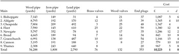
There were nine mains in all. Of these, the Aldgate, Bishopgate, Cheapside, Bread Street, Newgate Street and the Fleet Street linked to the upper cistern. The Gracechurch Street, Cannon Street and Thames Street were in the lower (Table 2). Hearne had reorganized the cistern system in 1741 because the Cheapside main was suffering supply problems stemming from the Fish Street hill, up which the pumps had to drive the water to reach the supply zone. Many customers were leaving to go to the New River Company.
Main statistics from Hearne's report

Source: London Metropolitan Archives ACC/2558/MW/C/15/102.
Despite the increased pumping capacity, there were still difficulties in getting water to customers. Among these, air in the mains was a serious problem because bubbles caught in corners could hamper or even block flow.Footnote 45 Air could enter the pipes via the engines, which could suck it in at low tide. This happened if there were holes at the end of the suction pipes above the water line. Air could also enter the mains by other means, such as when repairs were done on the pipes. The company's usual method for draining the air out was to force it by water, trusting that enough customers had left their service pipes open waiting for water to let the air vent. Failing this, the pipes could burst. Hearne was planning on adding stopcocks to the mains near the engine to prevent them from draining during engine repairs.Footnote 46
Maintaining a good supply throughout all the mains to thousands of customers, especially in extraordinary circumstances, was an active process involving all the turncocks. The turncocks took care of two or three mains each, and were responsible for opening and shutting valves along the mains to distribute water according to a schedule throughout their supply district. Should there be a fire, they would rush to the appropriate valves to send all the water possible to serve the fire engines. Moreover, turncocks on other mains would be alerted and would redirect some of their own supply into the affected main. To increase the robustness of supply, there was a series of pipes with valves linking each of the adjacent mains spread throughout the city. These links meant that even if all the pumps serving a main were not functioning, it could still be filled with water from the other engines.Footnote 47
Although Hearne judged ‘these works may justly claim the preheminence of any other water works in the world from their scituation, power, constant performance, and extensive usefullness’, he recommended three major improvements. First, he thought that the devices that floated wheels D and E in the fourth arch were too expensive to maintain, and gave too little benefit. Second, he suggested replacing one of the six inch pumps in the second arch with one of seven inch bore to help supply the Cheapside main at low tides. Third, he thought that seven inches was too small a diameter for the mains coming from the engines, and created too much friction against the flow. Eight or nine inches would greatly improve the situation, and be less liable to burst under the force created by the engines. This change, however, would cost in the order of £2,000, significantly more than any of the mains in their entirety had cost to build (Table 2). Given that the tenants were generally well served with water, he doubted the directors would agree to this until they leased the third arch of the bridge from the City, at which point the new mains could be of nine inch bore. Fourth, Hearne recommended that new valves be put on the mains to allow the water to be shared between them more easily, and to facilitate repairs.Footnote 48
Finally, Hearne had a couple of recommendations about how to decrease the friction in the main network. He suggested replacing all the square elbows with curved ones. Secondly, the way in which the mains contracted along their length also caused avoidable friction. He thought it would bring ‘infinite advantage’ if they were to remain the same seven inch diameter from the engines up to the very last service pipes. The service pipes were the ones that connected to customers’ houses, while the mains were the primary distribution pipes. Currently, the ‘highest tenants would have a greater and more lasting supply of water which at present in many places is very precarious espicially in neap tides and dry seasons’. The mains diminished from seven to three or even two inch bores in some cases. These contractions had the same effect as valves in causing friction and hindering ‘the water from dispersing among the services with that velocity as it is raised’. The mains should have diameters larger than their service pipes, particularly if as was almost always the case, a large consumer of water drew from it.Footnote 49
The largest part of the report was a complete account of the LBWW's pipe network. Hearne described each of the nine mains down to the location of every valve and minor service pipe. The company itself had not known the locations of all its pipes before this work. It had been building and modifying the system for a century and a half by the time Hearne got to work. He admitted that he almost gave up the task for its difficulty and the frustration of finding the course of pipes under the streets in heavy street traffic. He was finally able to succeed by waking very early on summer mornings to do his surveys before the traffic became too thick.Footnote 50
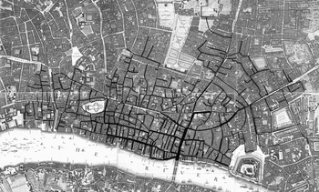
The LBWW did not know its own network in detail because it had grown organically, without any predetermined plan. The water was supplied simply as far as the flow could reach. The turncocks were certainly aware of the locations of all the valves as they would turn them on a daily basis, but this was evidently a job learned by apprenticeship. One turncock would train the next so that he would know the order and timing of the turnings. Pipes needed to be replaced constantly, but their location was determined only when work was required. The LBWW served water over an area extending to Chancery Lane in the west, half the length of Whitechapel Road in the east and almost to Shoreditch in the north. Some streets had many LBWW mains running through them. Fish Street Hill to Gracecurch Street had five mains from the bridge up to Fenchurch, and many others, such as Leadenhall and Thames Street, had three for some distance. Although the mains each had their own supply zones, these overlapped, and interconnections between the supply sub-networks allow water to be transferred from one to another should there be breakages or interruptions to supply caused by repairs.Footnote 51 The entire network has been reconstructed from Hearne's description and is shown on Figure 3.
All the London Bridge Waterworks’ mains and pipes as reconstructed from Hearne's report. Hearne specified the location of all mains and pipe in the streets. Overlaid on John Rocque's Map of London, 1746.

This supply area overlapped extensively with the New River’s. By the 1740s, the New River was able to reach everywhere that the LBWW supplied. The two companies did not, however, compete as they had in the years from the Great Fire through 1700. In 1738, they signed an understanding whereby they agreed not to use ‘false pretences or clandestine means to be used to gain or perswade any to become tenants for the water, by underletting or otherwise’. Nor would they take on the other's customers if they were in arrears.Footnote 52 Despite the attempts at peaceable co-existence, the LBWW's great disadvantage vis-à-vis the New River stemmed from its dependence on waterwheels on London Bridge: its supply was irregular. The LBWW was at the mercy of the tides, whereas the New River had water available in its reservoir at all times. The City of London itself used the New River's water, not the LBWW’s, to fight fires for this reason.Footnote 53 Despite the LBWW's expansion, therefore, it was running into serious limitations. Unless it could find water supplies other than from the bridge, these limits would become more serious.
The mains in the streets were 58,965 yards total length, or just over 33.5 miles (53.6 km). About 92 per cent of this was of wood, with the rest of lead and iron. The cost of the pipes at current rates was £10,378, with another £5,921 for the waterwheels and pumps, for a full total cost of the machinery of £16,300 (see Table 2).Footnote 54
The employees and operations
Keeping the LBWW functioning required many employees. The company employed 19 people, although it contracted for others regularly to lay pipes and pave the streets. A secretary kept the books and communicated with the company's directors, while the surveyor was responsible for the works. He kept them in good repair, and supervised the paviours, who were responsible for repairing and lay new pipes in the streets. The surveyor also managed the turncocks, as well as the millwrights at the company's works who manufactured new parts as needed. A storekeeper kept the inventory of all parts.Footnote 55
There were also four collectors who dealt with the LBWW's customers, or tenants as they were known. They tried to sign up new ones if possible, and kept the logbooks of who should be making payments. They collected these payments on a quarterly basis. They also verified vacant houses to ensure that no water was drawn there by thieves. Finally, they also checked that the turncocks were keeping to the established schedule and that the customers were properly served with water. Should there be a problem, they would try to find the turncocks somewhere in their areas (or walks) and work with paviours to remedy defects in the pipes. In total, the LBWW had 7,320 tenants. Since some of these were landlords who owned a number of houses, it served over 8,000 houses in all.Footnote 56 Some of the larger tenants were brewers and sugar refiners. The LBWW and the other water companies were important suppliers to London's 200 or 300 breweries.Footnote 57
The five turncocks were assigned an area of the city through which they walked opening and shutting valves so as to distribute water to houses. Houses were not constantly supplied, but typically received water for a few hours for three days a week. They reported back to the main office at high and low water when the wheels were not turning to check the complaints books. Tenants who had complaints would go to the main office on London Bridge to speak to the doorkeeper. The turncocks were to try to determine what substance there was to the complaint and fix it if possible. They were also supposed to report back on all faults that had been fixed.
In addition to these, there was a ‘supernumerary man’ who had no set task, although he mostly acted as a replacement turncock. A doorkeeper and housekeeper both worked at the main office, as did a watchman at night. Finally, there were three millwrights who worked from 6 am to 6 pm and kept the waterwheels and engines. At every low tide, they would descend down to the water line to the suction pipes to check for problems and keep the intakes clear. They also had to work on alternate Sundays to take care of the works, and had to be ready to come in to work at night at any time of year for repairs if needed.Footnote 58
After 1745
Perhaps because Hearne died in 1748, no significant changes were made to the work until the early 1760s. In an attempt to address one of its crucial competitive disadvantages with the New River, the LBWW for the first time built a steam engine at large expense on the north shore of the river at Broken Wharf to supply water at low tide when the waterwheels were stopped.Footnote 59 The horse pumps there had been abandoned in the 1730s.Footnote 60 A steam engine offered the possibility of escaping the limitations of the bridge and tidal power. The engine proved weak, however, and the engineer John Smeaton was soon called in to try to improve it.Footnote 61 A second important change came in 1761 when the LBWW leased the third arch of the bridge, an empty one situated between the two it already occupied. It also started to supply Southwark by laying a pipe from its waterwheels on the north end of the bridge along its length to the south side, and there supplied a zone in the immediate vicinity of the bridge. The third arch had been empty since 1718, and the LBWW had tried twice unsuccessfully shortly thereafter to lease it. The bridge itself was dramatically altered in 1760 when all the old medieval buildings were removed to ease traffic, leaving the LBWW as the sole occupant. Despite the new waterwheel, the LBWW by 1765 was running short of supply capacity. Part of the problem was that the main arch of the bridge had been widened from 1759 by merging two arches to improve the flow. To the extent this succeeded, it also decreased the flow through all of the LBWW's waterwheels. Two other arches (the Long Entry and the Chapel locks) had been closed to compensate, but this only made the current through the main arch even stronger, creating a powerful eddy downriver that threatened the ships passing through the arch. The supply problem was made evident at a fire on Bishopsgate Street, when ‘notwithstanding [the LBWW] have had the assistance and advice of most experienced and able artists in mechanics’, it had taken over two hours to heat the steam engine sufficiently to raise water to the fire.Footnote 62
To gain more capacity, the LBWW petitioned the City of London to lease yet another arch, this time the fifth arch of the bridge. Ship owners, however, counter-petitioned because they feared the eddy through the main arch would become even more dangerous. The City council for its part was divided. Some councillors were willing to grant another lease, but others raised issues with the main running along the bridge to the south shore. It was leaking and the water was clearly causing deterioration of the bridge at some points, especially at the main arch in the centre of the river.Footnote 63 The City finally decided to commission a number of surveyors (engineers) to report and make recommendations on the best way to deal with the matter. One idea they were to consider was that of leasing yet another arch, this time the second from the south shore, and blocking the southernmost arch to increase the current to the second one. This would allow the pipe along the length of the bridge to be removed. The questions were passed to a number of prominent civil engineers. They were Smeaton, Thomas Yeoman (surveyor of many canals), Robert Mylne (the New River's chief engineer and bridge designer) and James Brindley (renowned canal engineer). With the exception of Mylne, who objected to new leases on the grounds that, expiring in 2082, they were too long, all the other surveyors recommended the plan for two new waterwheels.Footnote 64 Ship owners, however, still raised concerns about the speed of the current being dangerous for navigation and liable to undermine their piers around the bridge, and so the matter was sent back to the surveyors for their consideration, this time Smeaton, Yeoman, Mylne and John Wooler (an engineer who designed bridges).Footnote 65 In response, Smeaton and Yeoman reiterated their original opinions, and recommended approval for the two waterwheels, while Mylne was joined by Wooler in arguing for keeping the flow more open and less powerful so as to diminish the wear of the bridge. The City council voted to approve the two leases, with the sole proviso that they could be cancelled by the City at any time should the condition of the bridge require it.Footnote 66 It was to be Smeaton himself who designed and built the wheel for the southern arch.Footnote 67 The end result of all these alternations and additions to the bridge was that by 1780, the LBWW was the last significant tenant on the bridge, and now occupied 6 of the 19 arches. When it was first built, the LBWW was a small element in one arch of the bridge, but by the late eighteenth century, it had in effect become one of the bridge's pre-eminent features.
In 1779, a fire that started in a building adjacent to the bridge destroyed the water tower but did not reach the waterwheels or pumps. Almost all the archives of the LBWW went up in flames but the 1745 report escaped unscathed. The company managers considered whether to rebuild the tower or not, and discovered by experimentation that they could pump water directly into the mains without a reservoir and still give a satisfactory supply. They connected the steam engine to the mains as well, although it had normally only been used at low tides. The new arrangement was made possible because their engineer at the time, John Foulds, designed a cylinder into which the pumps forced water, and to which all the mains were connected (Figure 4).Footnote 68
Foulds’ cylinder used to share water between all the mains, situated at the base of London Bridge. Engraving from 1779. Courtesy London Metropolitan Archives, City of London.

Although the LBWW recovered, the company came under pressure from various sources from 1780, most especially the deterioration of its vast pumping infrastructure. At this time, it was paying 50s per year per share in dividends, with a total income from water rents of £9,686.Footnote 69 The managers had to embark on an extensive set of repairs that saw them rebuild every waterwheel they had except the one in the fourth arch. In addition, they agreed with Boulton & Watt in 1784 to replace the steam engine at Broken Wharf with one of Watt's patented engines for £600 plus £50 per year thereafter.Footnote 70 The LBWW only managed to do this by exhausting all their capital and borrowing £7,000 from James Wood, their own treasurer. Most of these works were completed by 1794, and although the new engines were more efficient than the ones they had replaced, the total income from water rents was only £1,000 over what it had been in 1780. Another source of pressure on the company was the changing face of the City of London itself, which was its primary area of supply. Its character was changing, as many houses were being cleared away for commercial buildings.Footnote 71 The new Bank of England building lost the company tens of houses, as did the removal of most houses along the Thames to make way for wharves and warehouses. The East India Company was also clearing away houses to make way for its entrepôts. A final headwind for the LBWW was the New River Company. Although the agreement was still in place between the two companies, the LBWW consistently lost customers to the New River when it tried to increase its rates, effectively locking in prices over decades. The only opportunity for growth came in Southwark where the population was growing and competition was less.Footnote 72 The result of all these pressures was that the managers were forced to lower the dividend to 40s per share in 1794, and then 20s after that, before finally rising to 30s in 1798 when the whole debt was finally repaid.Footnote 73
The new century witnessed the demise of the LBWW and even old London Bridge. Many new water companies were incorporated in London from 1806, destroying the agreement between the LBWW and the New River. They also introduced iron pipes on a large scale, imposing heavy capital costs on all existing companies as they replaced their entire wood networks with iron. The LBWW, however, did not rebuild its network of pipes in iron. Furthermore, it did not supply the higher-pressure water that other companies were offering, and its water was of poorer quality as the Thames became ever more polluted. The result was that by 1820 it was on its last legs. The City of London's decision to replace London Bridge to ease navigation on the Thames in 1822 ended the 240-year history of the LBWW. Its base of operation had never left the bridge in a significant way during that entire time.
Conclusion
Two features defined the LBWW throughout its entire history: its situation on London Bridge, and its links to the City of London. In regard to the first point, the LBWW's range of operations were circumscribed to what was possible given its physical situation on the bridge. While the New River Company in particular was supplied by sources located at a higher elevation than the metropolis, the LBWW had to pump water up out of the river, and could only produce as much as its current-driven waterwheels allowed. Furthermore, the LBWW's evolution was intertwined with the bridge’s, and, with time, the LBWW was an increasingly dominant feature of the bridge. Originally, the LBWW was one of many buildings on the bridge, and occupied only two arches. As the reorganized LBWW grew after 1700, it had to seek more capacity constantly, both by leasing more arches from the City, and by repeatedly rebuilding its machines. By 1770, around a third of the bridge's arches were taken by the LBWW, and all the other buildings had been cleared away. Changes to the bridge could also affect the LBWW negatively. When arches were opened up to increase the flow through the bridge, it decreased the current on the LBWW's wheels. Over the long term, however, the metropolis outgrew the bridge which had been adequate for hundreds of years. As it deteriorated, the City finally decided to remove it, and the LBWW went with it.
The second defining feature of the LBWW was its link to the City of London. This was first of all a physical link. The limitation of waterwheel pumping meant that the area the LBWW supplied was largely confined to the City of London rather than the metropolis as a whole. Even as the new owners of the LBWW invested lots of capital over the course of the eighteenth century by rebuilding all the waterwheels and adding new ones, the LBWW's geographic reach was still limited largely to the City. This was despite the expansion of London suburbs where other water companies found growth. Its restriction to the City meant that LBWW suffered as the City itself become more commercial and less residential. Furthermore, because the City controlled the bridge, the LBWW was also politically linked to the City, relying on its good graces especially when it wanted to expand. The City's generosity towards it, manifested through low rents and even loans, allowed the LBWW to be established. Moreover, over the course of the eighteenth century, the City did not clear the LBWW off the bridge even as other buildings were removed because the City relied on LBWW water.
Finally, the LBWW's history was also one of evolving water technology within a broader European and British context. Technological influence at first came from the Continent. Waterwheel technology was imported from Germany in the sixteenth century where it had developed. Once in London, this formed the base of a company that elaborated water supply technology to an impressive scale. Over its history, the LBWW went on to provide water to over 10,000 of the buildings in the rapidly expanding city, and supported a number of industries, particularly brewing and sugar refining. The London context was important: it was especially the City's wealth and size that allowed the LBWW to find a willing market for its piped water. The growth of the LBWW was particularly strong after 1700 when the company was acquired by new owners who invested large sums. It was after this period of expansion that Hearne described the works in his report of 1745. The report revealed that the LBWW's evolution had been slow and haphazard, to the degree that no one even knew where many of its pipes were. Nevertheless, it also revealed the many strategies the company relied on to provide an adequate water supply, such as the water tower, and interconnections between mains. London came to be admired for its water supply in the eighteenth century, and the LBWW's technological achievement was a noteworthy part of it. Finally, the network water supply technology that had evolved in London served as an exemplar for other cities after 1800, even as LBWW, which had been the foundation of this industry and central to its history, declined and disappeared.