Introduction
Lapland, an indeterminately bounded region in the far north of Europe with a population of various ethnic groups speaking a variety of languages, became an object of unprecedented national and international attention during the 18th century. This land bordering on the Arctic Ocean had been attracting European explorers and the Swedish crown since the 1500s (Lähteenmäki and Ferrand Reference Lähteenmäki and Ferrand2011; Lähteenmäki Reference Lähteenmäki2006b: 10–29), but it was only in the utilitarian age of the 18th century with its rapid developments in science, mercantilist economic policies and emerging nationalist ideals that was opened a new era in the history of Lapland. The region was beginning in earnest to find a place on the economic and political map. The research carried out by Swedish-Finnish scholars and a stream of dissertations in the field of regional history created the foundation for a new internal awareness of Lapland, which was then exploited in the course of the economic developments and closed border politics that were typical of that century.
The aim of this paper is to describe and analyse the status of the northeastern region of Swedish Lapland, called Kemi Lapland, which bordered on Russia, in the light of the investigations, descriptions and guides for regional histories published by Swedish-Finnish scholars during the 18th century. How did these scholars confront the local peculiarities of the north, and in what form was information gathered to contribute to the new picture book of the realm?
Although a number of studies of the expeditions made by 18th century scholars to the north have been published in recent years (Pihlaja Reference Pihlaja2009; Sörlin and Bravo Reference Sörlin and Bravo2002; Barton Reference Barton1998), academic research has so far paid little attention to the grass roots issues of the local features of the north and their significance for the kingdom as a whole. The main emphasis in earlier work was on the scholars themselves and the tightening of the centralised administrative grip of the crown. Another characteristic of this work is that it was concentrated geographically in one area, the Torne river valley and the Gulf of Bothnia coast, which is quite natural, as these were the areas that the 18th century scholars visited. The result has nevertheless been a distortion of the impression provided of Lapland as a whole, and we are prompted to ask what the situation was like in the northeastern part of Swedish Lapland, the Kemi Lapland region, on the Russian border. How did it differ from conditions elsewhere in Lapland, and was the border location of the region taken into account in any way in the 18th century?
An attempt will be made in this paper to view the newly constructed and disseminated local character of the north in the context of the country's overall economic and regional policies on the one hand and in the context of the newly introduced academic practices on the other. The concrete manifestations of these reforms in academic practices that will be considered here are contemporary documents dealing with Kemi Lapland and a detailed guide to the writing of local histories published in 1782.
A new regional panorama of Sweden built on the ruins of the former superpower
The interest in regional history that arose in Sweden towards the end of the 17th century was inspired above all by the interpretations of history put forward by Olaus Rudbeck the elder, who set out in grandiose fashion in his Atlantica (Rudbeck Reference Rudbeck1679–1699) to link this northern world power, the birthplaces of its population and the origins of its language with classical antiquity, the cradle of civilisation. The number of attempts to trace and investigate the history of specific regions began to increase as scholars searched for evidence of past greatness in the rank and file of the realm. This devotion to the security of one's home district and in this way to the history of the whole country was to some extent a product of the long years of crisis through which the people had lived. The traumatic experiences of the early decades of the 18th century, the ignominy of the Great Northern War, the violent occupations of the ‘eastern province’, that is Finland, by the Russians in 1713–1721 and 1742–1743, the economic problems and the loss of the status of a world power had left the Swedish kingdom in a state of shock. As a means of recovering from these upheavals, the educated sector of the population had set out determinedly on a programme of recuperation. Both the leadership and the ordinary citizens needed to have their self esteem restored, and the means chosen for doing this was the study of the country's common history. A similar view of the situation has been put forward by Päiviö Tommila, who maintains that it became a matter of importance in Sweden-Finland on the termination of the Russian occupation in 1743 to lay emphasis on internal reconstruction and the seeking of compensation for the territorial losses in terms of improved internal welfare: ‘It was in this spirit that new attention came to be paid to local conditions (Tommila Reference Tommila and Jokipii1996: 10–11). The therapeutic effect of history was based on the opportunities that it provided for the comforting exercise of looking in detail at the surroundings in which one lived, defining their boundaries rather more specifically than before and recording their past and present cultural features in the form of a written history: an intact, reinvigorating national narrative.
As the historical bibliographies show (Suomen historiallinen bibliografia 1986–1990), the work of reconstructing a picture book of the Swedish regions was undertaken throughout the country, in the countryside as well as in the towns and cities and in the north as well as the south, but it was not only the dispelling of former traumas that attracted the gaze of many people towards the north; at least as important were the economic and patriotic interests of the new utilitarian age, as many authors have emphasised (Eliasson Reference Eliasson1999: 35; Korpijaakko Reference Korpijaakko1989: 467–491). The revised laws of the kingdom of Sweden (1734) tell us much of the more determined grasp that the central authorities aimed to establish over the country, and as far as Lapland was concerned, it was above all the settlement decree of 1749, offering exemptions from tax and conscription to attract settlers to the far north, that proved to be an efficient key to the inclusion of Lapland within the sphere of the kingdom's regional policies. Under the new national economic programme, crown officials were required to gather information on the climate, physical conditions, minerals and commercial prospects of this northern region as well as on its population and their tax paying potential, and this operation placed the north on the agenda for the country's decision makers as never before. The more precisely defined policy of Sweden towards the northern parts of the realm nevertheless suffered a serious setback in 1751, when negotiations over the boundary with Denmark-Norway in the north ended in Sweden being cut off from the Arctic Ocean coast, which it had so coveted in the early part of the previous century (Ingman Reference Ingman1884–1895).
In a broader European context the collecting of detailed information during the 18th century was a matter of the interest shown not only by politicians but also by scholars in the country's still uncharted margins and of a desire to control and supervise them, in effect to exercise the power of the centres over the peripheral areas (Foucault Reference Foucault1995: 191–193). It was in this sense, too, that the polar regions and the northern circumpolar zone (to which Lapland belonged) became an object of unprecedented curiosity, so that the number of expeditions to the Arctic Circle and beyond increased greatly as a result of the investments made in such undertakings by governments and by the scientific societies founded all over Europe during the 18th century. The preferred destination for such expeditions, for climatic reasons, was the European north, that is an area that included Swedish Lapland, northern Norway and the Kola Peninsula in Russia. This area was readily accessible by ship, as the Gulf Stream kept the Arctic Ocean coast navigable all the year round, and a second route was also possible which involved sailing from Stockholm to Tornio. The new research methods available in the 18th century sent the scientists out to make observations and conduct experiments in the field, and Lapland rapidly became a natural, air conditioned laboratory in which first hand observations could be made on weather conditions, the flora and fauna and the population of the region (Pihlaja Reference Pihlaja, Lähteenmäki and Pihlaja2005: 26–29, Reference Pihlaja2009: 271–282).
Reaching out for the last wilderness
Perhaps the simplest definition of a region is a part of the earth's surface which can be distinguished from its surroundings by virtue of a certain characteristic or set of characteristics (Kytömäki and others Reference Kytömäki, Ervasti, Paananen and Toivonen2007). Swedish Lapland fits this definition extremely well, as it was from the outset something ‘different’ and ‘original’ on account of its multicultural ethnic composition, a blend of the Sámi, Finns, and Swedes, and the exceptional regulations that governed it, which partly resulted from this. Lapland had a taxation system of its own for Sámi people, for instance, and its own elementary schools, known as ‘catechist schools’. On the other hand, its post and communications networks were less well developed than elsewhere in the country, which meant that the region was somewhat isolated, distant and distinctly different.
The defining of a region also implies the defining of its boundaries. The French sociologist Didier Bigo, for instance, has pointed out that a boundary is never natural but is always an institution created by a political process that defines what lies within that boundary and what lies outside and imposes a measure of conformity on the population living inside the boundary and their ways of thinking (Bigo Reference Bigo, Anderson and Bort1998: 149). This is what it was hoped would happen in Lapland. The drawing of boundaries is not an easy task, however. All the time one is dealing with administrative or negotiated political boundaries the situation is fairly straightforward, but when it comes to defining cultural or social boundaries the process is far more complicated (Massey Reference Massey1991: 24–29).
The difficulty of defining regions and places and the problems attached to the drawing of boundaries were well known to those studying culture from early times. The Finnish folklorist Seppo Knuuttila has observed, for instance, that while places have their physical, geographical locations, they acquire their cultural meanings from life, mediated by people's experiences and narratives (Knuuttila Reference Knuuttila, Knuuttila, Laaksonen and Piela2006: 7). Meanwhile the British geographer Doreen Massey has emphasised that every place has its own sense of place but not a single, seamless, identity (Massey Reference Massey1991: 24–29; see also Ashworth and Graham Reference Ashworth and Brian2005) and the geographer Yi-Fu Tuan, in his deliberations on place and home, has noted aptly that a sense of place can be an emotion that readily evaporates, but it can equally well be a deep-seated, lasting emotion, as in the case of a person's relation to his home as a place (Yi-Fu Reference Yi-Fu and Mels2004: 45–46; see also Yi-Fu Reference Yi-Fu2003). The question of who defines the images of regions and places is subject to a constant power struggle. The images we have in our minds are guided not only by our perceptions but also by our actions (Karvonen Reference Karvonen1999). The success of an attempt at governing an area is dependent on the credibility of the competing images that people form of that area and whether these images manage to achieve hegemonic status so that they are adopted as self-evident facts.
The two main groups of actors who set themselves up as the creators of the new images of Swedish Lapland and more specific profiles of northern localities in the 18th century were the local ministers of religion and the young men from Lapland who had qualified as students. In the terminology of H.K. Bhabha, these may be referred to as the ‘mimic men’ (Bhabha Reference Bhabha1995: 85–92) who transferred the values, norms and practices espoused by the central powers to the area that was to be colonised, at the same time as they were engaged in assigning values to that area's own culture and everyday life. They were operating in the middle ground between three cultures, Swedish, Finnish, and Sámi, on behalf of the power machinery of the Swedish state. The power wielded by the ministers working in the Lapland region and the students who went on to publish dissertations was manifested in written form through authorised publications that were to serve as a basis for the whole image of Lapland that was to be projected, and later on for the exploitation of the region's natural resources, that is the felling of the forests, harnessing of the rivers for hydroelectric power and construction of reservoirs during the 19th and 20th centuries. As Michel Foucault has suggested, knowledge and the exercise of power are inseparably linked, and there can be no knowledge without discursive practices (Foucault Reference Foucault2007: 203–206). Thus we must acknowledge that the images of Lapland and the writings that shaped the reality of the places did not arise of their own accord but were an integral part of the political, economic and cultural power struggle that was being waged at the time. University professors fulfilled an equally important role to that of the local ministers and young students with respect to the production of more accurate local information on the northern areas and its communication to the general public of the time and its inclusion in political agendas, for, as was the custom, it was they who chose the topics for the students’ dissertations and supervised their work, even taking part in it on occasions (Laine and Laine Reference Laine, Laine and Laine1997: 14–24). Meanwhile, the role of the ministers was important in the collecting and direct communication of local material.
The 18th century was also crucial for the governance of these border areas in the sense that it was then that a deliberate campaign began to instruct people interested in conducting research, making observations and describing their home districts with regard to what facts should be included in the character or identity of a particular area in order to construct as convincing a picture of the regions of the country as possible. The opening up of the borders of Lapland to settlers in the late 17th century had led to the production of a few maps, but now, during the 18th century, an entirely new databank based on field observations was being superimposed on top of that old knowledge. The National Library of Finland's continuing electronic database of 19th century newspapers contains 441 references to descriptions of areas and parishes located in what is now Finnish Lapland (Finland, National Library 2011; see also Varpio Reference Varpio1997; Lähteenmäki Reference Lähteenmäki2006a).
Many Laplands – many localities
A region, place or local community can be analysed on at least three levels. The clearest way of looking at it is with the eye of the cartographer, as a physical surface, region or place that it is not necessary actually to visit in order to gain a good impression of what it is like. The second way is to treat the region or place as a social space, and the third is to evaluate it as a mental or emotional state. In the latter case the object will manifest itself to the historian through reconstruction of its social networks and practices, which are bound in terms of time and place. The reconstruction of a sense of place in this context requires that the source material should include locally produced texts, documents or information preserved as a matter of tradition.
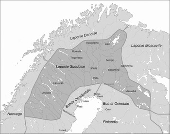
In view of the fact that the northern regions were not very well known in the early 18th century, the scientists and cartographers from Europe created surprisingly consistent maps of Swedish Lapland (The Carta marina of 1539 was the first map that provided a fairly realistic impression of northern Europe (Magnus 1539)). For example, the Carte des courones du nord, published in 1706 by the French geographer and cartographer Guillaume De L'Isle, also known as the ‘First Geographer to the French King’, depicted (De L'Isle Reference De L'Isle1706) the northern parts of Scandinavia and showed Lapland as an area extending from the uplands outside Umeå as far as Kiruna and from Inari to the environs of Kuusamo. The region bordered on Laponie Moscovite (Moscow Lapland) in the east, Laponie Danoise (Danish Lapland) in the north, Bothnie Orientale (Ostrobothnia, Österbotten) and Bothnie Occidentale (Western Bothnia, Västerbotten) in the south and Norvege (Norway) in the west. The indeterminate nature of the northern boundary of Lapland is reflected in the fact that Utsjoki and a part of Kilpisjärvi were not located in Swedish Lapland according to De L'Isle's map (Fig. 1), which indeed conformed to the actual state of affairs, as the boundary between Sweden and Norway was not defined until 1751. It is also interesting that the area around Tornio and Aavasaksa, which was the furthest north that the majority of expeditions reached, was similarly not marked on the map as belonging to Lapland.
Swedish Lapland in 1706. Source: Carte des Courones du Nord by Guillaume De L'Isle.

De L'Isle's map gives the impression that Lapland at that time was a compact regional entity that would be relatively easy to govern, but a more profound look at conditions in the region soon indicates that this is an illusion. It was not, in fact, an integral region in any other sense than when looked at from the south, that is administratively it formed part of the Swedish province of Västerbotten. As early as the 13th century it had been divided for trade and taxation purposes into six parts, or ‘Laplands’ in the parlance of the time, the most extensive of which, and commercially the most productive, were Tornio Lapland, centred around the Tornio River, and the easternmost division, the vast territory of Kemi Lapland that bordered on Russia. (Of these, Kemi Lapland and half of Tornio Lapland were located with the area of the present day Finland and the remainder, the other half of Tornio Lapland together with Piteå Lapland, Luleå Lapland, Åsele Lapland and Lycksele Lapland, lay in the present day Sweden). These were in turn divided into Sámi villages, or siida, each of which had a character of its own. By the beginning of the 18th century, however, the ethnic make up of the various parts of Lapland was somewhat variable, comprising members of the various Finnish tribes, the Karelians, Ostrobothnians and the people of the other parts of Finland, Häme, and Savo, who had settled along the major rivers in the north, principally the Tornio, Kemi and Muonio Rivers, Swedes who had established themselves at the mouths of the rivers Skellefteå, Umeå, Luleå, and Piteå and various Sámi groups inhabiting the fjeld uplands, the upper reaches of the rivers and the lake shores. The Sámi people in themselves formed a highly heterogeneous group, representing numerous languages and cultures, so that the Sámi of Swedish Lapland, northern Norway, and the Kola Peninsula alone were divided into at least nine linguistic families (the Southern Sámi, Umeå Sámi, Piteå Sámi, Luleå Sámi, Northern Sámi, Skolt Sámi, Inari Sámi, Kildin Sámi, and Ter Sámi). Indeed, the same could also have been said of the occupation structure of the population, as the people made their living by trading, transporting goods, working newly cleared farms, fishing, hunting, or leading a nomadic life as reindeer herders. Likewise, the landscape of Lapland was broken up in a geological and vegetational sense into numerous smaller areas characterised by particular soil types or surficial deposits and a series of vegetational zones: the fjeld uplands and screes of the northern and western areas, the forests of the central area, the expanses of open mires, the tundra, and areas of natural meadows and the low lying areas on the sea coasts (De l'Isle Reference De L'Isle1706).
The eastern border area comes into the security policy agenda
The most interesting of the above areas as far as the 18th century was concerned was the northeast region of Swedish Lapland, known as Kemi Lapland, as this area attracted particular attention from officials and scholars, being one of the most extensive distinct parts of the region and one that was still largely unknown on account of its poor accessibility and sparse settlement. Its riches in terms of furs and fish were known of old (Enbuske Reference Enbuske2008: 154–170), but it was still uncertain whether the area could also provide minerals and other natural resources for the benefit of a kingdom that was striving to improve its economic image. It says something for natural conditions in Kemi Lapland that foreign expeditions still did not dare to enter the area at all in the 18th century, and it also says something for the ethnic transformation of the area that Kemi Lapland became the principal target for Finnish settlement in the 18th and 19th centuries, a ‘promised land’ for new farmers (Lähteenmäki Reference Lähteenmäki2006a: 187–188).
The importance of Kemi Lapland in terms of security policy arose from the fact that it formed a northern borderland and interface between Sweden and Russia on the one hand and Sweden and Denmark-Norway on the other. Since the information produced by various expeditions, both Swedish and foreign, had been concentrated on Tornio Lapland up to that time and had been incorporated more or less unchanged into descriptions of the whole Lapland region, this role of Kemi Lapland as a sentinel in the east had scarcely been noticed earlier. Now, however, it began to attract attention as an important borderland. This was a century during which war broke out between Sweden and Russia on numerous occasions, and during which Russia twice occupied the Duchy of Finland, which bordered onto Kemi Lapland, first in 1713–1721 and again in 1742–1743. Kemi Lapland itself was never occupied, as it did not belong to the Duchy of Finland until 1809, but at times of war the Swedish authorities were apt to look on Lapland as a source of additional living space. Settlers in Finland were relieved to flee over the border into Kemi Lapland to escape the Russian atrocities. The wildness would protect them even when their villages in the south were threatened with Russian attacks.
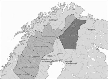
Isolation and exceptionality as a buffer zone and outpost were the defining features of Kemi Lapland in the 18th century. As a borderland area it stood out from its neighbours, Tornio Lapland, northern Norway, and the Kola Peninsula, at least on linguistic, economic, and ethnic grounds. An illustrative example of the exceptional physical conditions in the area may be gained from the Charta öfver Wästerbottn och Svenske Lappmarcken published by S.G. Hermelin in 1797 (Hermelin Reference Hermelin1797; Fig. 2). This map drawn by Anton Swab and Clas Wallman is very much more detailed than the earlier 18th century maps, in addition to which Kiemi Lappmark is depicted with a greenish colour, as if to stress its special nature and set it apart from the rest of the region. (For 18th-century maps of Lapland, see the collection of the old maps of the north Calotte in the library of Lapland, Rovaniemi (Rovaniemi Library 2011). The north Calotte is the region of the northernmost Europe, Finnish Lapland, north of Sweden, north of Norway, and the Kola Peninsula in Russia. The transnational concept of the ‘North Calotte’ was constructed in the 1940s–1950s by politicians who wanted to activate economic and cultural co-operation in the north).
Kemi Lapland in northeast Sweden in 1797. Source: Charta öfver Wästerbottn och Svenske Lappmarcken by Anton Swab and Clas Wallman.

Those mapping the special characteristics of Lapland in the 18th century did not base the picture they traced of the region solely on a few results they had gained in their research, but rather had a relatively good, if sparse, collection of earlier descriptions available to help them. Quite reliable published works on Lapland can be found from the mid-16th century onwards (Magnus 1995, originally 1539; Magnus Reference Magnus1973, originally 1555), and although they mainly concerned Tornio Lapland, there were a few printed accounts of Kemi Lapland, too (Alanus Reference Alanus1639; Tornaeus 1672; Regnard 1681; Tresk Reference Tresk1928, originally 1642–1643; Itkonen Reference Itkonen and Schefferus1963: 5–8; Boldt Reference Boldt1899–1900; Chydenius Reference Chydenius1754).
Unfortunately for future generations, Gabriel Tuderus, curate of the parish of Inari, finished his own account so late that it could not be included in the Lapponia collection edited by the German-Swedish historian Johannes Schefferus in 1673, but some indirect information on Kemi Lapland was contained in that classic volume, as Schefferus’ assistant and informant in the project, Olaus Sirma, was a Sámi from Sodankylä, in the same area (Schefferus Reference Schefferus1979). It was no coincidence that Schefferus’ review of conditions in Lapland came out at almost the same time as the boundaries of the region were being thrown open to settlers. Once again the interests of scientific investigation seem to have accorded with those of the national exercise of power. The Lapponia volume was indeed commissioned by the government, but all in all it was seen later to have marked a substantial step forward in general knowledge of Lapland throughout Europe and was translated into both English and German within the year, and into many other European languages soon afterwards.
Numerous other accounts of conditions in Lapland were produced in the universities of Sweden from the late 17th century onwards, some of which were similarly commissioned works, but perhaps the best known of all the expeditions to Tornio Lapland were those of the botanist Carl von Linné (Linné Reference Linné1737) and the physicist Anders Celsius (Celsius Reference Celsius1743) and of the churchmen Ericus Brunnius and Anders Hellant. The latter, who had both been born in the north, acted as interpreters and guides on various expeditions carried out by foreign scientists. Brunnius was a minister in Ylitornio and Hellant had been born in Pello, the son of a merchant. Brunnius’ dissertation, presented in 1731, was concerned with the town of Tornio and Hellant's equivalent publication of 1738 with salmon fishing in the Tornio River (Brunnius Reference Brunnius1731; Hellant 1740; Hellant Reference Hellant1749). Hellant was also an adviser to the most famous of all the 18th century expeditions to the region, that led by Pierre-Louis Moreau de Maupertuis (Maupertuis Reference Maupertuis1738) with the aim of measuring an arc of the meridian in the Tornio valley and financed by the King of France in 1736–1737. Many other descriptions of Tornio Lapland, mostly of a more general and popular nature, similarly arose from journeys made to the region during that century, such as the tour undertaken by the Frenchman Aubry de la Motraye in 1718, that of the Englishman Matthew Consett in 1789 (Motraye Reference Motraye1723; Consett Reference Consett1789), and a positive flood of visitors in 1799 that included the Italian Giuseppe Acerbi, the Swedish colonel A. F. Skjöldebrand who belonged to his party and the Englishman Edward Clarke (Acerbi Reference Acerbi1802; Clarke Reference Clarke1819; Skjöldebrand Reference Skjöldebrand1801–1802).
A local image of Kemi Lapland
The picture of Lapland that the Swedish and foreign scholars and travellers had created by the beginning of the 18th century was a highly generalised one that was apt to give the impression of fairly uniform conditions existing throughout the region. Although the visitors had for the most part concentrated their attention on the Torne valley, which had become a veritable ‘destination’ by that time, their descriptions were intended to apply to the whole of Lapland. However, there are also some fairly detailed accounts of life in Kemi Lapland that emphasise some features of that region.
The printed works of the ministers sent to Lapland by the Lutheran Church allow us to see how the generalised regional perspective can be focused more precisely to yield more detailed, local accounts. One example of this would be the dissertation of Johan Wegelius, son of the vicar of Sodankylä in Kemi Lapland, that was published in 1758 under the title Tanke-Försök om Hushållningens Hinder och Hjelp i Kimi Lappmark [Attempts of thoughts on the economic obstacles and help in Kemi Lapland].
Dissertations of this kind that reveal a new desire to capture grass-roots local information were to create the basis for a new drive to publicise Lapland throughout the country. One extremely significant step forward as far as the dissemination of local and regional information was concerned was the fact that from 1752 onwards dissertations could be published in Swedish rather than in Latin if they dealt with topics in history, topolography, natural history, mathematics or physics that were of particular relevance to Sweden (Laine and Laine Reference Laine, Laine and Laine1997: 19). In the dedication of his work to his father, Wegelius notes how this now grey haired man had spent his days enduring all manner of difficulties and hardships in the vast wildernesses of Kemi Lapland, far away from his friends and peers in the course of discharging his unselfish life's work (Wegelius J. Reference Wegelius1758: preface). This dedication indicates just how exhausting daily life in Lapland could be for ministers belonging to the educated classes, and at the same time highlights the distinction between the way of life of the ministers and that of their parishioners. Although they lived in the same localities, they were parts of different communities. Information of this kind on internal hierarchies and networks within the community is especially valuable for tracing the sense of place.
Johan Wegelius had been born in Sodankylä, so that he was familiar with conditions in the area beyond the Arctic Circle, and like Brunnius and Hellant, he devoted much of his dissertation to possible means for improving economic conditions in his home district. Similarly his brother, Henrik Henriksson Wegelius, who was a minister in Utsjoki, published a study of his home district, dealing with dredging of the Kemi River in order to improve access to Kemi Lapland (Wegelius H.H. Reference Wegelius1755). Johan Wegelius had been inspired by his brother's example to write about his home district, but another important influence in this direction had been the supervisor of dissertations at Uppsala, the Finnish-born natural historian Pehr Kalm, who had been a pupil of Carl von Linné and was a member of the Royal Swedish Academy of Sciences and the Uppsala Scientific Society. He also became the first professor of economics at the Royal Academy in Turku (Abo) and subsequently its rector and was famous for his books on his travels in America including En Resa till Norra Amerika [Travels into North America] 1747–1751 (Kalm Reference Kalm1756).
A new paradigm came into research in economics and the natural sciences around the mid-18th century and was reflected in an increase in regional studies, to which new value had begun to be attached. Contemporaries report that up to that time Lapland had been regarded by scholars as ‘a mongrel of nature and nest of horrors’, but now the time had come to dispel that misconception, and what was more, to do so with the help of people who had grown up there. The mission was an obvious one: to create a new image of Lapland as a land of fertile fields and park like meadows (Wegelius, J. Reference Wegelius1758: preface).
Johan Wegelius describes the point of departure for this as having been an unprepossessing one. No one really believed that Lapland could be developed or that agriculture could take place there, and it was claimed that the whole region was just a barren cap on the north of Europe, a land of mountains and fells that rose up to meet the sky, of pine bogs, mires and remote forests. Prominent among its defining features were the long, cold winters and short summers and the risks attached to farming. Another drawback in the summer was the myriads of mosquitoes that made it impossible even to keep one's eyes open. It was against prejudices such as this that Wegelius set out to do battle in his dissertation. He maintained that the fells of Lapland were to be found only on the northern margins of the region, that the mires, where they existed, could be drained, and that grain, rye, barley and oats, and turnips would ripen in Lapland just as well as in areas further south, as had been demonstrated by Pehr Högström, a vicar in northern Sweden, in his Beskrifning öfver de till Sveriges krona lydande Lappmarker [Description of Lapland which belongs to the Swedish Crown] (Högström Reference Högström1747).
According to Wegelius it was ignorance that had caused Lapland to be misrepresented and vilified. Illustrative of the change in the attitude of the crown to the peripheries was Wegelius’ observation that where previously ‘the powers that be’ had themselves decided that the region was useless and good for nothing, so that little was known about its natural beauty and for this reason nothing had been done to improve conditions there, it could now be noted with a measure of gratitude that at last ‘our enlightened times’ and the gracious monarch had drawn attention to the extreme corners of the realm and in this way had done something to promote ‘development’ in Lapland (Wegelius, J. Reference Wegelius1758: 1–2).
What, then, were the arguments put forward in their writings by the scholars who had grown up in Lapland and were acting as ‘mimic men’ of the crown? The new policy of introducing farming was to be encouraged, Johan Wegelius maintained, if only for the practical reason that the local inhabitants, in their great diligence, would soon have hunted all the game available in the forests and emptied the lakes and rivers of fish. Even the reindeer, which had been the real riches of the people of Lapland, had declined in numbers in latter years. Thus the need for reforming the economy of the region was something that was arising from below, although the inhabitants themselves had not realised this until they were faced with an emergency and had only been willing to take on the role of farmer when all else had failed. Hunting and fishing were so firmly ingrained in their minds that the idea of seeking a livelihood in some other way had never occurred to them, especially since farming required a degree of long term commitment that the ordinary people of Lapland would find it hard to muster. The people wanted to go on living in their own way, a fact that Wegelius in his capacity as an intermediary deplored. Although he, too, hailed from Lapland, he regarded himself, being from a clerical family, as representing a superior and more mature way of thinking and acting. This discourse was a built in feature of the society of four estates that prevailed at the time, in which the common people represented the lowest and least developed group that had to be looked after by the others, bearing in mind, of course, that these people who were to be looked after included both the Sámi and the Finnish settlers: that is the dividing line within society was not a matter of ethnic origin but of social class (Lähteenmäki Reference Lähteenmäki2006a: 303–305).
Another major problem that Wegelius believed argued in favour of a changeover to farming was the sparse population of Kemi Lapland. If the authorities wanted crops to be cultivated in the region they would have to offer tax concessions and other benefits to attract people to move there. The existing population was so small that the people would not have the resources to undertake large scale draining and tilling of the land (Wegelius, J. Reference Wegelius1758: 3–5). If Lapland were to flourish, he claimed, all the men to be appointed as ministers there should have not only training in theology but also a thorough knowledge of household economics and natural history (Wegelius. J. Reference Wegelius1758: 12). It was also clear that the settlement issue had a security policy dimension as well, the aim being to commit a certain population to living in the less hospitable marginal areas, as an inhabited borderland was always more secure than an uninhabited one.
Wegelius emphasised that the measures he was advocating would not be of help to the whole of Kemi Lapland but would for the most part benefit his own home district, Sodankylä and its surroundings. Thus the concept of ‘Kemi Lapland’ was seen as being further subdivided, for the more detailed the information that could be gathered, the more grounds there were for recognising distinct parts of the area, for example the low lying lands of Sodankylä, the lakeside area of Inari and the fjeld uplands of the northernmost areas. As the choice of livelihood depended on natural conditions, this also meant that each community had its own distinctive cultural and social features as well. One consequence of this approach was, of course, that the regional characteristics that the writer had set out to identify were progressively reduced to local ones as he delved into his topic in greater detail. This is a problem that has been experienced by many other scholars in the course of time, leading Massey to consider in the case of her own home district how she could give expression to the particular familiar sense of place that it had for her. She knew that it was there somewhere, but it was extremely difficult to put it into words or pictures (Massey Reference Massey1991: 24–29).
The few studies that were made of Kemi Lapland (Enckel Reference Enckel1790; Fellman Reference Fellman1910–1914; Castrén Reference Castrén1800) were insufficient to break down the exclusive myth of an ‘exotic frozen area in the north’, but some help was received from certain newspapers that came out towards the end of the century. The interest shown nationally in matters of borderland policy was reflected in the fact that extensive articles about the northeast of Swedish Lapland, that is Sodankylä and Utsjoki, appeared in the academic journals edited by Henrik Gabriel Porthan, Tidningar Utgifne Af et Sällskap i Åbo and Åbo Tidningar. Although only a few places were honoured with such coverage at the time when these papers came out, it is no surprise that Porthan should have shown this degree of interest in the north, as he had only recently published a study of writings by King Alfred dealing with ‘the north of Europe’ (Henrik Gabriel Porthanin tutkimuksia 1904; Porthan Reference Porthan2007).
Altogether four articles on Utsjoki appeared in Porthan's journals, a two part account in 1772 and again in 1791, while a two part article on Sodankylä was published in 1784. If we wish to examine what picture was given of the region, at least we can say that the source-critical background augured well: the writers were in all cases the local ministers.
The first articles were from the pen of the curate, Anders Hellander, and had been written in 1751, at a time when the northern boundary with Norway was being negotiated, a procedure that altered the status of Utsjoki somewhat, since the region was left on the Swedish side. Thus in this case, too, the regional description was directly connected with the interests of the state. The journal's editor explained that the article on Utsjoki was being reproduced for readers in full because the area concerned was ‘so distant’ and ‘so unknown’ and hoped that the reader would be entertained by it on account of its novelty (Porthan Reference Porthan1772a): that is even in the earliest connections writings about Lapland had begun to take on a certain entertainment value. The main purpose behind Hellander's article, as in the case of Wegelius' dissertation, had been to evaluate the suitability of the region for this new source of livelihood sponsored by the crown.
The common title of the second articles on Utsjoki, ‘Anmärkningar om Utsjoki Socken i Kemi Lappmark’ (Porthan Reference Porthan1791a, Reference Porthan1791b), indicates that not even the author, with his local origins, knew whether Utsjoki belonged administratively to Kemi Lapland or Tornio Lapland. In fact it belonged to the latter. In accordance with the general view of science that prevailed at the time, the article notes that life in the region was dominated by the climate, but here, as in Sodankylä, the change in means of livelihood from hunting and fishing to agriculture was looked on as a matter of economic necessity. The Sámi who had lost all their reindeer and ended up destitute had settled along the Teno valley and taken to sheep rearing and small-scale cultivation of the land.
The articles on Utsjoki published in January 1791 were based on an account submitted by the vicar at the time, M. Sund, and drew attention to the ethnic composition of the population living at latitude 69°N. 65% of the households in the area lived off nomadic reindeer herding and regularly moved across the border to Norway for the summer months and also paid taxes there, while the remaining 35% were engaged in the new occupation of animal husbandry. A comparison was also made with the people of Inari, who were said to make a living by fishing and a little livestock rearing. The strictly local viewpoint had been expanded in this article, however, to consider the situation over the whole region, as the reader was treated to a description of the whole economic region of the Arctic Ocean coast, with its markets, shipping and grain trade with places as far away as Arkhangelsk and Copenhagen (Porthan Reference Porthan1791a, Reference Porthan1791b). Thus Swedish Lapland, which appeared in the earliest descriptions fashioned in the south as an isolated peripheral conjunction of six Laplands, was now emerging as an open, international economic zone on the Arctic Ocean coast with its own interaction network. In other words, the vertical line of communication between Stockholm and Lapland was matched by a horizontal functional network covering the whole of the northern cap of Scandinavia (Lähteenmäki Reference Lähteenmäki2006a: 305–308).
In the light of this account, we may well ask whether such an image of Lapland that combined the local and the regional in a new way was detectable in the description of Sodankylä published in 1784. Following the spirit of the times, Sodankylä was approached first by outlining the administrative framework and only after that by considering the population of settlers. The ancient Sámi culture of Kemi Lapland was in decline and only one in ten of the households during the 1780s had members who understood the Sámi language. A second interesting detail is the trend for the population to move south, as most accounts at that time spoke only of the northward migrations associated with settlement. The new means of living, agriculture, was proving unreliable, and those who fared badly were already drifting back to the south, to Kemi, Tornio and Oulu. Thus this article makes no secret of the poverty that could follow a change of livelihood (Tegengren Reference Tegengren1952). Alongside all this a feature of the old way of life evidently still survived, in that it was noted that people in the easternmost villages of Sodankylä still paid their taxes to Russia, as did some of those in Inari (Porthan Reference Porthan1784a, Reference Porthan1784b)
Gathering data for valid comparisons
If we are to consider how the writings referred to above were related to the general development of research methods during the period concerned we must first of all note that the descriptions that the various ministers gave of their home districts and the dissertations of students from Lapland produced on this basis marked a major step forward in 18th century research into regional and local history. That trend culminated in the expeditions arranged by the regionally based university student associations in the following century for the purpose of gathering material on the local history and folklore of their home districts. It has been calculated, for instance, that about 50 dissertations on local history were produced at the Royal Academy in Turku [Abo] between 1730 and 1800 and between 25 and 40 in Lund. The most active centre, however, was the University of Uppsala, where more than 90 local descriptions were published between 1717 and 1792 (Tommila Reference Tommila and Kuusanmäki1974: 7). Official schemes for collecting such material gained momentum following a decree issued to the universities by the Swedish Chancellery Committee in 1731 encouraging the publication of such dissertations on local topics. Later, in 1752, parish clergy were ordered to draw up descriptions of their parishes, and government surveyors began to make more systematic tours of the borderlands (Juva Reference Juva1940: 74; Anttila Reference Anttila1964). These surveys may be seen as attempts to find appropriate means for producing and categorising information on the outlying districts of the realm.
The inspiration behind regional studies in Finland at the end of the 18th century was, of course, H.G. Porthan, mentioned above, whose interest in history, folklore, folk poetry and the Finnish language led him to travel a great deal within the country. In his De scepticismo historico [Historical scepticism], the first textbook of historical methodology to be produced in Finnish, he called for source criticism, practical fieldwork and the use of statistical documents for the purposes of historical research. Statistics were to be kept and classifications drawn up of all possible phenomena, such as plants, animals, the population, natural resources, farms and trends in migration (Porthan Reference Porthan1792: 25–28). As Foucault has aptly noted, no detail is inconsequential for the disciplined observer, not because of the significance of the details as such but because it is through details that power takes a grasp over individuals (Foucault 2000: 191–193, 202).
The overwhelming interest in details during that period is well reflected in the dissertations presented at the Royal Academy in Turku [Abo]. Porthan's guide to writing and classification plan, ‘Plan, Til en Sockne-Beskrifning [Plan for the decsription of a parish]’ was published in the journal Tidningar Utgifne Af et Sällskap i Åbo in January 1782 to act as a model for the classification of regional and local data (Porthan Reference Porthan1782), and even before that, in 1741, the country's surveyors had received instructions for the gathering of similar information from the director of the Swedish Land Survey, Jacob Faggot, in the form of his booklet Tankar om Fäderneslandets känning och beskrifwande [Thoughts on the fatherland's familiarity and description] (Juva Reference Juva1940: 71–72).
Porthan was of the opinion that every account of a parish should have its detailed information arranged in four categories, the first of which, as for all local and regional histories, should be ‘Politica’, for the purpose of placing the area or region on the administrative map, that is in the appropriate province, diocese and assize court district. Data should be provided on the size of the area or region and its boundaries, and once these external details had been dealt with, attention should be turned to the buildings in the area, its villages, churches, farms and cottages, after which a description should be provided of the population, marital status and variations in numbers. All in all, there was a long list of material to be compiled under this heading before the scholar could proceed to the next category, ‘Physica’, a detailed description of the natural conditions prevailing in the area, its climate, weather, forest resources, harbours and waterways. The next section in an 18th century local database was to be ‘Oeconomica’, details of the sources of livelihood in the area concerned. It was important here to record all relevant aspects, such as the extent of agriculture, mining products, and stumpage prices paid for timber, manufacturing, trade, cottage industries and an estimate of the extent of poverty in the area. It was essential simply for taxation purposes to know how people made their living. As far as the final category, ‘Historica’, was concerned the main object of attention was church history. The investigator was expected to find out the ages of the churches in the area, the seats of bishops, the locations of graves and the existence of obituaries. This reflects the deep sense of social order that prevailed at the time. The central point of each parish was its church, which was usually situated physically in the centre of the community even in the northern villages, as a manifestation of both divine and secular power. Note was also to be made, however, of all ancient monuments, king's stones, sacrificial sites, sites of buried coins and old, historical ballads, followed by a list of significant people and families and last of all information on the common people, features of their character, their customs and freedoms, their beliefs, their preferences in terms of food and drink, their manner of dress and their building styles (Porthan Reference Porthan1782: 25–28).
This was Porthan's model for collecting increasingly accurate data on Lapland that could be used for drawing up new economic and political maps of the region. It would not be easy for scholars to collect these data, however, as a great deal of detail was called for, and thus it was not surprising that the task was to be entrusted to people who had at least the level of education of a minister of religion. The idea behind Porthan's methodological guidelines was to create order by dividing the information into progressively more detailed categories, so as to ensure that comparable data were gathered for all parts of the country, and also to provide the monarch with the means for controlling his territories and the people who lived there. In this sense it would appear that the classic classificational approach used by Carl von Linné in his Systema naturae (Reference Linné1735) may well have influenced the early models for studying regional and local history as set out by Porthan. Thus these apparently innocent guidelines for writing were ultimately intended to strengthen the power of the central government. The fact that the data to be acquired scarcely included anything related to the culture of the local people was part of the ideology of the times. As Foucault has observed, science in the 17th and 18th centuries had little to do with people, for it was only in the 19th century that the human sciences came onto the agenda (Foucault Reference Foucault1973: 344–345).
The climax of Swedish rule in Kemi Lapland and the culmination of the interest shown in the region was reached in summer 1802, when the Swedish scholar Göran Wahlenberg spent several months roaming around the area gathering material for his Geografisk och Ekonomisk Beskrifning om Kemi Lappmark i Vesterbottens Höfdingedöme [Geographical and economic description of Kemi Lapland in Vesterbotten jurisdiction].
The authorities were no longer content with accounts provided by local clergy but had sent Wahlenberg, who was amanuensis in the Department of Natural Sciences at the Royal Academy in Uppsala, to produce a thoroughly professional document with notes and comments on the sources consulted. In addition to his own fieldwork, Wahlenberg nevertheless made extensive use of earlier writings by ministers and cartographers and of the articles in journals that have been mentioned above. The very fact that it was possible to live so close to the polar regions at all was an amazing thing and a credit to Sweden. The preface to his work also serves well to reveal the security aspects of the authorities’ interest in the region: this sparsely populated multicultural area close to borders with Russia and Norway could not be left to its own devices (Wahlenberg Reference Wahlenberg1804: 3–8). This view of Wahlenberg's, if nothing else, suffices to show how important a border region Kemi Lapland had become in terms of security policy by the late 18th century, reflecting the shift of emphasis towards the borders of the kingdom that had arisen partly as a consequence of King Gustav III's war against Russia in 1788–1790.
An entirely different political message is conveyed by a later study of Kemi Lapland, that produced by the Finnish scholar A.J. Sjögren in 1828, entitled Anteckningar om församlingarne i Kemi-Lappmark [Notes of the parishes in the Kemi Lapland]. As the date of publication shows, the region had by that time been incorporated into the Russian Empire as part of the Grand Duchy of Finland, as of 1809, and this was reflected in the manner in which the region was presented. Sjögren's work was again a fully annotated professional study, but it differed from its predecessors in that it opened the region up in an interesting manner in the direction of Russia, the Kola Peninsula and the White Sea part of Karelia, a dimension that had been lacking entirely from the earlier Swedish and Finnish research. The frame of reference for narratives regarding Finnish Lapland, as Kemi Lapland and part of Tornio Lapland had now come to be called in 19th century writings, was now connected with Russian Lapland and Karelia, partly for the simple reason that the route travelled by Sjögren took him through Kemi Lapland to Arkhangelsk, the capital of the White Sea region (Sjögren Reference Sjögren1828).
Sjögren's study earned its author a place in the research network based in St. Petersburg and it was not long before he was elected to membership of the Russian Academy of Sciences. The significance of his work was also reflected in the fact that Jacob Fellman, the celebrated vicar of Utsjoki, published an extensive review of it in the magazine Suomi in 1846 (Fellman Reference Fellman1846). Thus Lapland drifted further east both physically and mentally to become part of the Finnic ethnic community, and the meaning and images attached to its areas and places came to be seen in a new light, in the context of a new state and its regional policies.
From mental images to empirical data
The above is an account and analysis of the economic and political interest shown in the localities of the far north of Europe in the 18th century, illustrated with examples from individual writings. At the beginning of that century Swedish Lapland still aroused wild fantasies of a land where the inhabitants were at a lower cultural level than elsewhere (Pihlaja Reference Pihlaja2009: 119–123), whereas by the end, the work of the academies of science, universities and government officials had led to a more realistic set of images and body of knowledge, although admittedly only partially so. The essential thing to ask at this point is what kind of information the central authorities wanted to ask for and collect. As we have seen from the categorisations used in Porthan's guidelines for writers, all the information was designed to be of use to the central power, the crown, and its economic and security interests. This may be appreciated from the young students’ dissertations and the contemporary articles in journals. In the spirit of the times, the cultures of the ordinary people of the Lapland region merited no more than a few marginal notes. As far as the composition of the available historical sources is concerned, this marks an exceedingly important strategic turning point, as it was during the 18th century that a substantial databank on Lapland was initiated and constructed employing a peephole from the south that emphasised the features that were of greatest importance from the perspective of governance of the region. The dissertations and parish descriptions have gained their power from the fact that future generations of historians regarded them as genuine, reliable sources, and took them for granted as true evidence of conditions in Lapland as they had been in the past. To some extent they are indeed just that, but the picture that they create of life in Lapland in the 18th century is distorted and incomplete, because of the approach that was adopted. Considered from a source-critical viewpoint, the documents concerned represent information that lays stress on the new economic policies of the time and the drive for political conformity. Rather than enabling us to reconstruct the state of society in 18th century Lapland, these contemporary writings provide a more convincing account of the interests that Stockholm had in the north.
At the same time the new local and regional historical data provide concrete evidence of the revised academic practices adopted by scientists at that time for compiling, writing, publishing and making visible the local features of given parts of the realm. Although the regions and localities were of value to those in power and to scientists only as territories subordinated to the central government, the process of gathering information, the public demand for local data and the curiosity shown by visiting travellers created a new enthusiasm for history and a local consciousness within the various localities, especially among the educated sector of the population. In that way what was ‘local’ came to acquire a new significance both locally and nationally. In the case of the history of Kemi Lapland it may be said that governance over the last wilderness areas came to be established in connection with this process, by which they became a recognised part of the realm. Viewed on a broader scale, the increased interest in local descriptions and the compilation of historical and social data during the 18th century also created a basis for the adoption of the nationalist ideology that had arisen in the Nordic countries, as elsewhere, towards the end of that century and for an awakening of interest in ordinary people and their culture. When new students or experienced scholars, such as Elias Lönnrot, who compiled the national epic poem, Kalevala, arrived in the villages of the borderlands with their notebooks to record examples of the cultural heritage, their informants were ready and waiting for them.