Introduction
In September 1912, Douglas Mawson, leader of the Australasian Antarctic Expedition (AAE) 1911–1914, was at Commonwealth Bay, Antarctica, making preparations for his far eastern sledging journey on which he would be accompanied by Lieutenant Belgrave Ninnis and Dr Xavier Mertz. The expedition's ship S.Y. Aurora was in dry dock at the Williamstown government dockyard in Melbourne, for repairs and refitting. The ship's captain, John King Davis, was about to embark on a voyage from Melbourne to Eden (37° 04′ S, 149° 54′ E), in New South Wales with Harald Dannevig, Director of Commonwealth Fisheries, who was then engaged in researching fish stocks in the seas off southeastern Australia.
Oceanography was recognised as a science by the beginning of the twentieth century. From early observations (Maury Reference Maury1859), to the celebrated voyage of H.M.S. Challenger (Mill Reference Mill1895; Murray Reference Murray1885), data relating to ocean depths, water temperatures, currents, sea floor deposits and biological specimens were gradually accumulated. Practitioners continually refined the design of equipment to improve reliability and accuracy in sounding, trawling and dredging operations (McConnell Reference McConnell1982; Jones and Jones Reference Jones and Jones1992; Carpine Reference Carpine2002). Limited work had been done in the Southern Ocean, but an oceanographic programme was a major focus of Mawson's expedition planning as outlined in his address to the Royal Geographical Society in London (Mawson Reference Mawson1911b). He had been further inspired by a visit to an oceanographic research laboratory in Paris, established by Prince Albert I of Monaco. ‘It is magnificent’ he wrote to Professor Edgeworth David at the University of Sydney. ‘To see it makes me want to push deep sea work’ (Mawson Reference Mawson1911a). In his brief to Davis in January 1912, prior to Aurora returning to Australia, he instructed as follows.
VII On arrival in Hobart after taking on board all materials belonging to the expedition the ship is to proceed to Sydney to be docked and repaired. It is hoped that free docking facilities will be afforded at the Government Docks. The deep sea gear is to be fitted without delay and a programme of oceanographic survey to be undertaken in the deeper waters off the Australian coast – special attention being given to that south of Australia. In Melbourne, Mr Dannevig of the Fisheries Department will be able to co-operate with or assist you. Professor David and Professor Masson should be connected with the oceanographic programme (Mawson Reference Mawson1912).
Professor T.W. Edgeworth David, University of Sydney, and Professor David Orme Masson, University of Melbourne, were members of the Australasian Association for the Advancement of Science. An Antarctic sub-committee, with David as chairman, was to oversee preparations for Mawson's AAE and to monitor subsequent developments, making decisions as necessary.
After the purchase of Aurora in England, oceanographic equipment for the AAE was assembled from various sources. Davis had applied unsuccessfully to the British Admiralty and to Sir John Murray, who had sailed on the Challenger and Michael Sars expeditions, for the loan of a Lucas sounding machine (Davis Reference Davis1911). The AAE's manager in London, Alfred Reid, later bought one with a 5000 fathom capacity and it was shipped to Hobart on S.S. Turakina (Reid Reference Reid1911). The Admiralty offered a Kelvin mark IV sounding machine, a set of Australian and Antarctic charts, chronometers, sextants, deep sea thermometers and associated equipment (Thomas Reference Thomas1911). Other polar explorers supplied the AAE with additional oceanographic instruments. Dr Jean Baptiste Charcot (Pourqois Pas?) sent Richter thermometers, J.Y. Buchanan (Challenger) lent the expedition a hygrometer, a reflecting circle and two deep sea thermometers. Ernest Shackleton (Nimrod) presented deep sea thermometers, a reversible water bottle and assorted equipment. Before sailing from London in July 1911, Davis travelled to Edinburgh to meet William Speirs Bruce, who instructed him in the use of equipment, lent the AAE a dynamometer, a reel of 7 ply wire to a depth of 2500 fathoms and the greatly appreciated steam driven winding engine (Davis Reference Davis1913). This engine had been designed for the sounding machine on Bruce's Scotia, for the Scottish National Antarctic Expedition 1902–1904 (Mossman and others Reference Mossman, Harvey Pirie and Rudmose Brown1978). He also supplied Davis with a double headed Monegasque trawl and had a 10 ft beam specially made for it in Granton, Scotland (Bruce Reference Bruce1912). Bruce was closely associated with Prince Albert I of Monaco, a keen oceanographer, who was generous in his support of expeditions undertaken by his contemporaries (Carpine-Lancre Reference Carpine-Lancre and Barr2008). The prince, via his chief collaborator, Dr Jules Richard, Director of the Oceanographic Museum in Monaco, approved the loan of several items to the AAE including water sampling bottles, trawl nets with clamps, finer nets and sounding equipment (Richard Reference Richard1911b). Mertz, prior to joining S.Y. Aurora in London, travelled from his home in Switzerland to spend several days at L'Institute Océanographique in Monaco, where he was given elementary instruction in the use of some equipment aboard L'Eider, the Institute's training vessel (Richard Reference Richard1911a).
Despite the careful preparation, Davis initially experienced problems when trawling and sounding in the Southern Ocean in January and February 1912 and again on a sub-Antarctic cruise to the Auckland Islands and Macquarie Island from May to July 1912. To Masson he wrote: ‘Our recent dredging cruise has been, as far as dredging goes, an absolute failure, but while this is disappointing, it has had this advantage – we have been able to try the gear and train the men to some extent’ (Davis Reference Davis1912a). Bruce continued to be supportive, sending written advice on the use of weights and toggles to overcome those problems. He added extracts from Challenger reports and hand drawn diagrams of operations (Bruce, Reference Bruce1912).
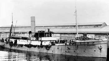
Oceanographic practice in Australia, at that time, was limited. The purpose-built trawler Endeavour (Fig. 1) had been built in the New South Wales (NSW) government dockyard in 1908 to a slightly modified design of the Norwegian research vessel Michael Sars (Hjort Reference Hjort, Murray and Hjort1912; Court of Marine Inquiry 1915). Dannevig was conducting an extensive survey of fish populations and oceanographic observations (Dannevig Reference Dannevig1913; McCulloch Reference McCulloch1915). Born in Norway in 1871, Dannevig had worked with the Fisheries Board of Scotland before arriving in Australia in 1902 at the invitation of the Agent-General for NSW. Mawson had arranged for Frank Wild, leader of the Western Base of the AAE, and another seaman, boatswain Duncan Peers, to spend time training with Dannevig on board Endeavour, prior to S.Y. Aurora leaving for Antarctica (Mawson Reference Mawson1911c). The Department of Trade and Customs gave permission for Davis to accompany Dannevig in 1912, on a return trip from Melbourne to the fishing town of Eden on the south coast of NSW (Lockyer, Reference Lockyer1912). Master Mariner George Pim, who captained Endeavour, was from a family well known (as Pym) in British nautical history. He had been in the lighthouse service in the Torres Strait and had also been associated with scientific research in New Guinea and nearby islands, charting and describing the region (Etheridge Reference Etheridge1915).
Endeavour at Hobart. The After Gallows, trawling wires and sounding machine can be seen on deck. The monkey island from where bearings were taken is above the bridge. Photo: Baily. Reproduced with permission of the Maritime Museum Tasmania.

During his career, Davis was burdened with enormous responsibility in the Southern Ocean and was, inevitably, the recipient of harsh criticism. Many referred to Davis by the name ‘Gloomy’. The second officer on Aurora described his captain as ‘complex’ and his diary is sprinkled with insubordinate mutterings about Davis (Gray Reference Gray1914). The AAE's administrator in Hobart quarrelled with him and attempted to dismiss him from command of Aurora (Eitel Reference Eitel1912). While much of that can be attributed to reluctant recognition of his authority as captain and as second in charge of the AAE, serious conflict with Mawson on the first British, Australian and New Zealand Antarctic Research Expedition (BANZARE) voyage (1929–1930) was also later revealed (Grenfell Price Reference Grenfell Price1962; Jacka and Jacka Reference Jacka and Jacka1988). A lack of understanding triggered severe criticism of Davis in Mawson's diaries and went undefended for many years, allowing the image of a stubborn, unreasonable and gloomy character to be perpetuated. It was not until an embargo imposed by Davis on his own diaries was lifted twenty years after his death that the opportunity arose to present a more impartial assessment of the clashes between these two strong personalities and of the consequences (Crossley Reference Crossley1997). Davis had loyal supporters including Ernest Shackleton, with whom he had sailed on board Nimrod (1907–1909) and Aurora (1916–1917). R.N. Rudmose Brown, who had experienced Antarctic conditions with Bruce on board Scotia (1902–1904) described Davis as ‘a brilliant ice master’. In a review of the AAE, he wrote:
Much of the success of the Mawson Expedition was due to Davis’ able handling of the exploring vessel and his splendid ice navigation. It was Davis also who was responsible for the valuable oceanographical work done between Australia and Antarctica – researches carried out in comparatively unknown seas and under adverse weather conditions (Rudmose Brown Reference Rudmose Brown1915).
The Antarctic diaries of Davis have been published (Crossley Reference Crossley1997) and his own books (Davis Reference Davis1919, Reference Davis1962) offer additional thoughts in retrospect, but this paper presents previously unpublished raw notes he made of operations aboard Endeavour, his impressions of Eden, references to photographs he took of both the vessel and the district, and subsequent correspondence. Images in a photo album, separately archived within the collection, were identified through visual research in Eden as those mentioned in the notebook. The notes, which on one level acquaint us with new settlements, industry and hopeful ventures, on another convey the attitude of the young Davis to his work and to the world around him. The men worked long hours during the week but Sunday excursions resulted in a supplementary layer of social commentary. More importantly, these notes inform the reader of an event which was a significant episode in preparation for the AAE's oceanographic work. This cruise of Endeavour is only briefly mentioned in some publications and not at all in other accounts of the AAE. We intersperse Davis's 1912 notes with brief explanatory comments placing them in context. Comments in square brackets are those of the authors of this paper. With minor editing (punctuation and spelling) his original notes are reproduced verbatim below with some of the photographs to which he refers.
Extracts from handwritten notes made by J.K. Davis during the voyage of F.I.S. Endeavour in September-October 1912
Federal Investigation Ship Endeavour
HC Dannevig, Director.
Capt Pym [Pim].
Built in Sydney Govt Yard 1908.
Melbourne Harbours and Ports.
Left Melbourne at 2:30 Sept 26th
Passed out of heads at 4:20. Considerable sea on rip, although none outside last quarter off ebb.
Cost £17,000 to build.
To run cost £400 per month.
Forward Trawl Board Endeavour to left on board vessel.
Saturday [28 September 1912]
All day steaming eastward in beautiful calm sea towards Gabo Island. During the afternoon a moderate breeze from SE. Sunset very fine and clear. Vessel making about 10 knots.
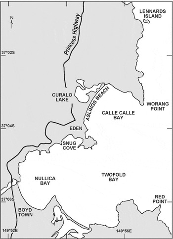
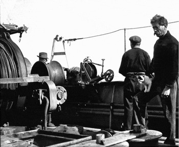
The Director tells me that we are to spend Sunday in Twofold Bay (Fig. 2) which is close to our trawling ground. This will be a good chance of seeing a little of the surrounding country. I took some photos showing the arrangement of the trawling winches sounding machines etc., which appear to be well arranged and powerful (Fig. 3). I feel very pleased to have an opportunity of seeing trawling work carried out in a vessel which has been designed and fitted for this work.
Map of Twofold Bay, Eden, NSW, marking sites referred to in Davis's notes. Modified, with permission, from Australian Hydrographic Service Chart AUS 192 Twofold Bay. Not to be used for navigation.

Trawling wires and Lucas sounding machine on the deck of Endeavour. Dannevig, here with ship's cat, supervised operations on board. Photo: J.K. Davis. Reproduced with permission of the State Library of Victoria.

Sunday Sept 29th
We arrived after a very fine passage in Twofold Bay this morning, anchoring in Snug Cove at 6 a.m.
When I got up it was after seven and the sun well up – a beautiful fine morning.
The bay is a wide one and is sheltered everywhere except to the eastward. On the northern side of it a fairly good wharf was to be seen, alongside of which the steamer Sydney was lying there. Boats call fortnightly on their journeys round the coast. Our first visitor was an itinerant fisherman who was anxious if we could supply him with bait, preferably shark, for his lobster pots four of which he carried in the stern of his boat (photo).
During the morning we remained on board and found it very pleasant sitting about in the bright sunshine. The Endeavour gig was put over and the men amused themselves sailing around the bay in her (photo). After lunch the Director and myself went ashore and landing at the wharf, climbed a fairly steep hill towards the small township of Eden (500 people). It was hot and very few people were to be seen and generally things appeared very quiet.
The Director decided to inquire for letters at the post office, which we found with some difficulty. Not being able to gain admittance to the office, it being Sunday, we made our way to the Postmaster's House which was close by. Here, we were received by the Postmaster and his family who welcomed Mr D as an old friend and invited us both in to take tea. It was very pleasant to sit down in a comfortable room and drink tea to which our host and hostess welcomed us in so hospitable a manner. On my expressing curiosity as to what there was to see our host offered to show us round. We set off along a good road which runs through partially cleared country, the gum and wattle trees still being plentiful on each side of the road. A few houses are scattered about near the main road, the photo being of a typical one which was named ‘The Hollies’ and is the residence of a Mr Boyd. After going some distance we retraced our steps and while passing a piece of cleared land our friend pointed out a very fine cow nearly all black which he informed us was a cross between an Alderney and Shorthorn and supplied its owner with 2 lbs of butter and 5 gallons of milk per day. It was named ‘The Dove’ but from an account of its conduct to two people who annoyed it, this was apparently entirely uncharacteristic of its behaviour.
Leaving the road we struck through a cleared patch of country towards the beach. On our way we passed a brick kiln (photo). The way that a house is built is typical of the resourcefulness of the Australians. A saw mill (worked with an oil engine) is started close to the scene of the building operations. If much is to be done the timber is cut from the bush, the bricks are made out of the clay and sand close by and the workmen live in tents close by until the building is completed. Only the parts which they cannot make here are ‘imported.’ We soon came to the beach which is of coarse sand formed apparently of granite crystals and very smooth and clear. The cliffs are apparently of sedimentary formation and are much folded and form a striking sight (photo). From the beach we returned to our host's house who insisted on our remaining with them for supper where we had a splendid meal, including homemade bread, butter and jam. Locally, a belief exists in the future of Twofold Bay as a great port and it would seem probable that this place will before long become much more widely known than at present. It used at one time to be a great whaling station but at present this is not as lucrative as formerly (Davis Reference Davis1912b).
[Twofold Bay, a natural harbour, approximately 3300 hectares and 36 metres deep (Harris and O'Brien Reference Harris and O'Brien1998), consists of Calle Calle Bay to the north of Eden and Nullica Bay to the south. Steep grades lead from the wharf at Snug Cove to the town. Davis, with his notes and photographs, has provided first hand historical accounts of Eden and some of the residents. The 1912 post office with attached residence now has the status of an historic building, while the operational post office has relocated to the centre of town. The Hollies, built in 1900, still stands on the Bega Road, now the Princes Highway. An image of a brick kiln near Lake Curalo, circa1930, appears in a collation of early photographs of the area (Davidson Reference Davidson1988). From there it is only a short walk to Asling's Beach, at one end of which is the ‘striking sight’ of the colourful, much-folded cliffs on which Davis commented.]
Monday Sept 30th 12
Light SW airs, smooth sea.
Left Twofold Bay at 6 a.m. steamed West [sic] about 1 hour and shot in 44 fathoms over mud, 6 miles from Red Point which hove S65 W True. This operation is an interesting one to watch. The net which stretches along the bulwark for 80 feet is attached to the trawl boards and is put over, the cod end first. When the net has sunk beneath the surface the vessel steams ahead at full speed and the wire is slacked out slowly from the two winches until 200 fathoms was out on each warp (usually 3 times the depth) Care should be exercised to keep an even strain on the wires. When the wires are out, the vessel steams ahead at 2 ½ to 3 knots with the trawl drawing over the bottom, the boards dragging over it on their edges. At 9 a.m. the trawl was hove in and found to contain a large variety of fish among them being flat head, gurnard, rays, dogfish a curious sea horse, John Dory, sword fish, also a large number of shells most of which were the home of a curious kind of crab which having a soft shell takes possession of any empty shell and uses it as a protection and a house. The net is hove up and the cod end emptied into a kind of bath fish pond formed with boards on the deck. The whole is then sorted. Flat head and other edible fish are put into a division and gutted, the others are thrown back into the sea. This would be worth £1 a ton as manure if landed, which would probably be done by a commercial trawler.
Fish in first haul:
Flathead prime 335 weighing 304 lbs.
10 Skate and Boar fish.
(Bullock talk)
Posted negatives.
2nd Haul
Depth: [no entry]
Position: [no entry]
Time: Towed 2 hours.
Result: A good quantity of fish, but mostly unmarketable. Considerable variety.
We arrived in Snug Cove, Twofold Bay at 6:30 p.m. and anchored off the pier. A boat came off to us with the pilot Capt. Davies who was evidently anxious to have a yarn with someone as he insisted on our coming ashore and entertained us the whole evening with the history of Twofold Bay, its grievances and its possibilities. This gentleman is pilot, custom house officer, Wharfinger and in charge of the lighthouse, but is not apparently overworked.
It was very pleasant to listen to all he had to tell of this country. He had been 12 years at Eden during which things had not gone ahead as they ought to have done. This he attributed to the fact that the settlement is on the wrong side of the bay and lack of railway communication. He also gave us information about the whaling here which seems to be a very small business, the average yearly catch being only 8 to 10 whales. The killers chase the whales into the bay between July and November. One of these killers is supposed to return every year and is recognized by its broken fin and called Humpy. The killers attack the whales, and drive them into the shallow water where they try to tear out the tongue which they appear to like. He told us that one right whale (called a black whale) had been caught in the bay and the bone from this animal fetched £1500. Out of each of the ordinary whales about 4 to 5 tons of oil is extracted which fetches up to £20 a ton (Davis, Reference Davis1912b).
[The harbour entrance is bounded by Worang Point (North Head) and Red Point (South Head), where an outcrop of heavily folded red rock juts into the sea. The depth of colour is the result of heavily oxidised irons in the exposed mud laid down in ancient river plains (K. Crook, personal communication, 15 June 2009; Steiner Reference Steiner1975). Davis recorded fish found in the area in October, 1912. The original wharf at Snug Cove has been extended and two other wharves added to accommodate the fishing industry in Eden. Fish taken in commercial quantities now in October include the flathead, gurnard, squid, perch, snapper, dogfish, john dory, sword fish, shark, skate and boar fish mentioned by Davis, as well as grenadier, gemfish, ling, whiting, trevally, flounder, tuna, and mackerel (NSW Department of Primary Industries 2009). Protected species in the area include the Weedy Sea Dragon, Phyllopteryx taeniolatus, which may be the ‘curious sea horse’ to which he referred.
Back in port, Davis enjoyed a long conversation with the harbourmaster. His concise record of their meeting indicates, as does his record of the excursion with the postmaster (29 September), his willingness to engage with local people and his interest in local issues. Whaling was a dominant topic. Accounts of packs of killer whales, Orcinus orca, herding various species of migrating whales into the bay where they were harpooned by men in open boats, are well documented in the history of Eden, with some individual killer whales achieving legendary status (Mead Reference Mead2002). This herding behaviour has been recorded elsewhere, for example operating as a coordinated pack, killer whales have been observed hunting crabeater seal, Lobodon carcinaphagus (Smith and others Reference Smith, Siniff, Reichle and Stone1981). Davis noted that the whale's tongue was the target of some attacks. Charles Wilkes recorded the sighting of a similar attack in Antarctic waters in 1840, where a large whale was unable to extricate itself from the hold that a killer whale persistently maintained on its jaw (Wilkes Reference Wilkes1845: 135). Whaling activity around Eden, already in decline in 1912, continued until the 1920s but is now replaced with whale watching, a major seasonal tourist attraction. The brief ‘bullock talk’ note could refer to a discussion about the teams of bullocks used to transport building materials and stores into the area and to the wharves for export (McKenzie Reference McKenzie1991).]
Tuesday Oct 1st [1912]
Started out at 6 a.m. light airs freshening to moderate NE breeze sea moderate commenced running a line of sounding and temperatures from Green Cape to ESE ward.
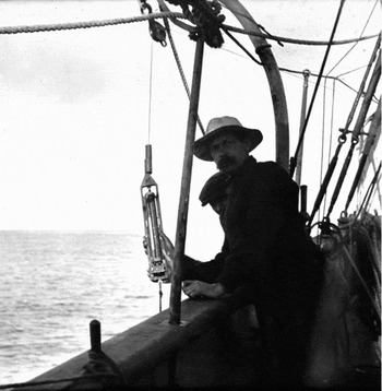
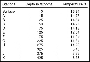
Stations are made every three miles and following is a list of temperatures, water samples (Fig. 4) being obtained at the same time (Table 1).
Dannevig with a seawater sampling bottle. Photo: J.K. Davis. Reproduced with permission of the State Library of Victoria.

Early morning observations of temperatures of sea water samples at increasing depth, ESE of Green Cape, NSW, Australia, recorded by JK Davis on Endeavour on 1 October 1912. Correlation co-efficient: r = −0.968749 indicates a high correlation between depth and temperature.

At noon anchored vessel in 470 fathoms with 1270 fathoms and a 3 ½ cwt kedge.
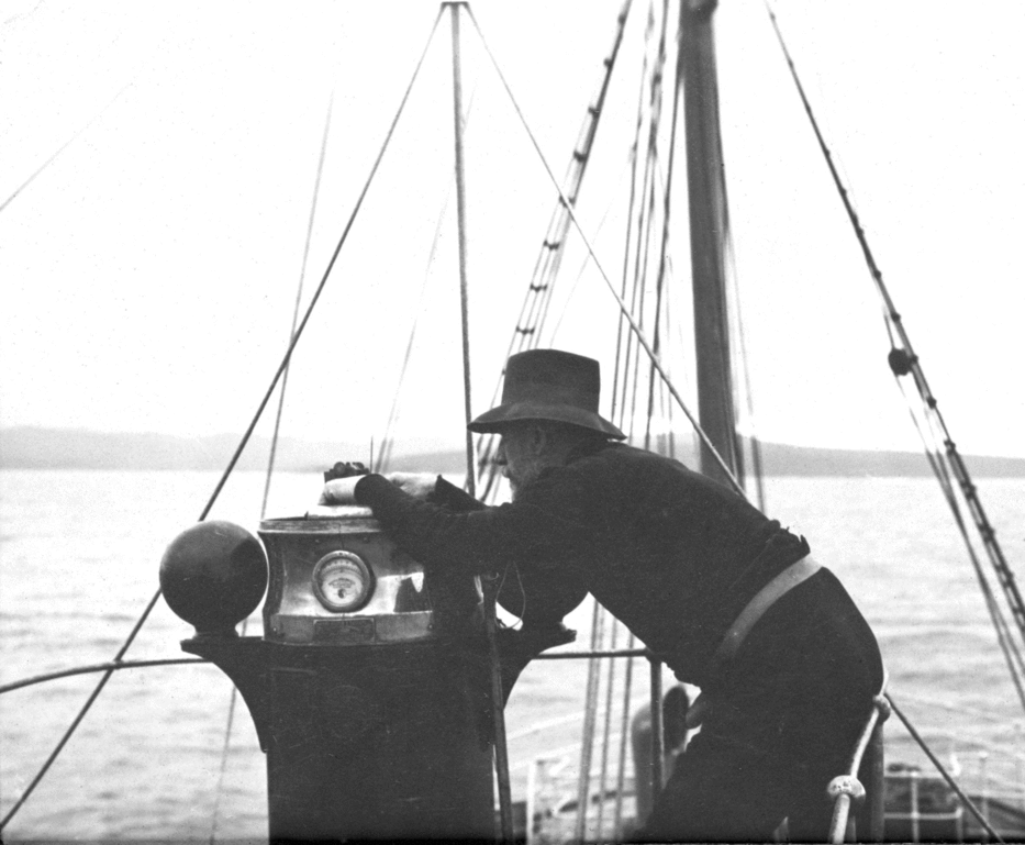
S72E true 17 miles off Green Cape (Fig. 5).
Taking a terrestrial bearing with the magnetic compass. This was mounted on the monkey island above the bridge. Note the iron compensating balls on either side of the binnacle. Photo: J.K. Davis. Reproduced with permission of the State Library of Victoria.

Light northerly wind and sea
Vessel not shifting her position at all.
At 6pm started to work Ekman Current Indicator.
This worked well.
Vessel lying steadily. Readings of it gave surface current setting S13E true approximate at 120 fathoms NNW true approximate. Work was carried on after dark and rendered possible by the vessel being fitted with electric light, two large clusters being placed in close proximity to the sounding station.
8 p.m. weather very clear and fine. Writing up these notes while current indicator is at a depth of 170 fathoms where it remains 35 minutes before hauling up to read.
Finished work at 11 p.m.
Wednesday Oct 2nd
Commenced work at 6 a.m. hove in wire and kedge which came up clear and took about an hour to heave up. This had held the ship without dragging throughout, the weather being fine.
Preparations were now made to use the Agassiz Trawl which I had brought with me.
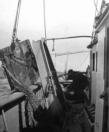
The Director decided to use the After Gallows (Fig. 6) and with the vessel steaming ahead and a 50 lb weight attached to the cod end, the net was shot. At 7:45 we were then in 470 fathoms and when 800 fathoms of wire had been paid out the net was found to be on the bottom. Speed was increased a little and trawl towed for two hours on muddy bottom.
The After Gallows with otter boards, chains and net, towards stern of Endeavour. Photo: J.K. Davis. Reproduced with permission of the State Library of Victoria.

The weight 70 lbs a fire bar was attached so that it would break away when dragging over the bottom. This it did.
L 37 21 S
Long 150 24 E
17.5 miles N 70 ½ W of Green Point
Depth 503 fathoms
Time 9:50 commenced to heave in
10:30 Trawl on board.
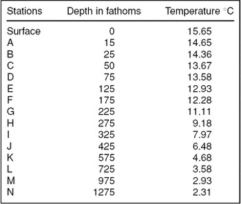
The trawl came up with good load 3 to 4 cwt of thick dark mud, containing many shells some protozoa shells (small) and also many small organisms. It was a difficult job to wash out the mud everyone getting plastered with it during the process. At noon attempted to sound with Lucas Machine (Fig. 3) but as there are not drivers on board the thirty pound lead on the end of the wire was insufficient to indicate when bottom had been reached. 2800 fathoms ran out and the wire parted on the first attempt to heave in. (Wire weighs 15 lbs to 1000 fathoms app.) We then proceeded to obtain serial temperatures (Table 2). These were obtained on a stranded line (wire) led through two lead blocks from the winch with the Ekman Water Bottle fitted with 1 Richter Thermometer and 14 lbs lead attached below thermometer with a line. Finished a second series of temperatures 15 miles further out than above at 12 midnight.
Afternoon observations of temperatures of sea water samples at increasing depth, using the Ekman Water Bottle fitted with a Richter Thermometer, near Green Point, NSW, Australia, recorded by JK Davis on Endeavour on 2 October 1912. Correlation co-efficient: r = −0.935081 indicates a high correlation between depth and temperature.

[There are no details of the second series of observations that day in his notebook.]
Oct 3rd
At midnight last we finished work and steamed towards the Green Cape light anchoring in 69 fathoms with kedge with 350 fathoms of wire. Work commenced again at 6 a.m.
Light NE winds and smooth.
A series of current observations were taken at this station which indicated a moderate current to North increasing in depth.
11:30 Commenced to heave up anchor as the bottom was rocky this was a very heavy heave, the vessel at times being hove right over on her side. The anchor came up eventually badly twisted. The big heavy trawling winch was frequently stopped by the strain on this wire which had a breaking stress of 19 tons.
12:30 pm Shot trawl in 48 fathoms with 150 to 175 fathoms of wire.
2.9 S 33E true off Green Point Light.
2:45 Knocked out fairly good bag. flathead, gurnard, squid, shells, black perch, etc.
3:15 Shot trawl again steaming about in Disaster Bay. At 6 p.m. knocked out and found we had made the biggest bag so far, about 8 cwt of flathead and about 1 ton of other fish (not marketable rubbish as it is called). We then steamed right up the head of Disaster Bay and anchored about a cable from the shore for the night. Everyone busy by the fish pond gutting and sorting the bag, the electric light making this possible.
Finished work at 9 p.m.
Glass falling rapidly.
Weather indicating a probable change.
Oct 4th
Got under weigh at 6 a.m.
Shot trawl in Disaster Bay at 7 a.m.
Glass low.
Weather still fine, mod NE wind but looking dirty.
Hauled the trawl at 11 a.m.
Good bag, though not as large as the one of yesterday evening.
11:30 Shot trawl again.
Weather unsettled, turning to rain and southerly wind at noon.
We knocked out at about 3:30 and as wind was freshening and weather looking dirty steamed towards Eden and anchored in Nullica Bay, which is well sheltered from all except easterly winds.
It was squally after we anchored, but otherwise fine. By the appearance of the sky, it looked as if there had been a hard blow to the southward of Gabo but that along this coast the high land had deflected the strong air currents upwards. I shall be interested to hear what weather they have had in Melbourne today.
Vessel steams 2 ½ to 3 knots an hour when trawling.
Oct 5th
Moderate and cold southerly winds.
Sea smooth, mountains very distinct.
Shot trawl closer in shore just north of Twofold Bay at 9:15.
Knocked out and found we had made the best haul of the cruise, nearly 12 cwt of prime fish, some very fine snapper and a great quantity of flathead. This was in 32 fathoms, about 1 ½ miles east of Bullara I. [now Lennards Island, Latitude 37° 01′, Longitude 149° 56′] Shot trawl again standing and knocked out at 2:30 p.m. to the eastward. The catch in this case was a poor one, the fish apparently being inshore. Several whales were seen.
At 3 p.m. we anchored in Snug Cove again and are to remain here till tomorrow night (Davis, Reference Davis1912b).
[The type of trawl which Davis brought on this voyage had been developed by scientist and engineer Alexander Agassiz (1835–1910) working in the Atlantic, in the Gulf of Panama and the deep waters of the Caribbean (Murray Reference Murray1911). As Davis mentions later in his notes (7 October), Dannevig was interested in the effect of tides on currents and the use of the Ekman current indicator was an integral part of Endeavour's operations. V.W. Ekman, a Norwegian scientist working with Fridtjof Nansen, developed this model in the early twentieth century, testing it on the Michael Sars (McConnell Reference McConnell1982: 144–146). Davis was disappointed that no drivers for the Lucas sounding machine were on board Endeavour. Drivers were attached to the wire to be lowered when ocean depths were being assessed. When the driver struck the seabed, a portion of the substrate could be collected and retained in a hollow compartment, which closed by means of a valve, allowing the sample to be brought to the surface (Davis Reference Davis1939). A Lucas sounding machine was also installed on Aurora and Davis would have appreciated an opportunity to observe this aspect of the equipment in action on Endeavour. Many models of water sampling bottles and thermometers were available to oceanographers. In this case an Ekman water bottle was used with a Richter thermometer and the results recorded by Davis are reproduced in Tables 1 and 2. Analysis of his two data sets found a high correlation (r-value) between water depth and temperature for each set. The use of electric light extended working hours and productivity. As a relatively recent addition to facilities available on board, it was worth noting.]
Oct 6th
Sunday. At anchor Snug Cove 8 a.m. Light airs, fine clear weather, bright sunshine.
After breakfast the Director and myself with one of the sailors, an Irishman named Paddy, left the ship in the dinghy and sailed over to Nullica Bay which is the SWern portion of Twofold Bay.
This part is well sheltered and formed the early settlement. We went chiefly to look at a large white stone house which had been the hotel but is now a ruin. It is close to the beach, which makes it a conspicuous object for some distance, and was erected by a Mr Boyd who was one of the early settlers and tried to found a township.
Over the door a stone informs you that Boyd Town was commenced in 1843 and apparently did pretty well at first but then for some reason gradually declined and only the ruins of various buildings, including an old church, remain at present. The country round here is very pretty and the beach clean and of fine golden sand. We spent the morning here and returned to the Endeavour at 2 p.m. During the afternoon Mr Litchfield, the postmaster, and his wife and daughters visited the ship (Davis, Reference Davis1912b).
[Again the men relaxed on Sunday, exploring the surrounding area and buildings which, a century later, are considered to have significant historic value. The ‘large white stone house’ visible from the bay was Boyd Town's Seahorse Hotel, abandoned when Ben Boyd's financial status was close to bankruptcy a few years after the hotel was built. The history of the area and the decline of Boyd's operations is summarised in The Twofold Bay Story (McKenzie Reference McKenzie1991). A severe bushfire in December 1926 destroyed many of the remaining buildings in Boyd Town and claimed the timber shingles on the roof of the old church. The abandoned hotel was not in the path of the fire and the original building has since been restored and extended, opening its doors for business again as the Seahorse Inn. The fenced ruins of the church stand on a nearby hill, shrubbery sprouting in the exposed interior. It is likely that the harbourmaster or the postmaster had mentioned the ruins as points of interest which Davis and Dannevig could visit during their time in Eden. Captain Thomas Jones Davies, from Launceston, Tasmania, but originally from the south of Wales, was harbourmaster, pilot and customs officer at Eden from 1903 to 1918. His logbook confirms Davis's account of Endeavour's movements (Davies Reference Davies1912).]
Oct 7th [1912]
Left anchorage at midnight and steamed North, experiencing a strong set to SSE. Arrived off Moruya at 7 a.m. and shot trawl.
9:30 knocked out clean bag of good fish consisting chiefly of flathead. This haul was in 68 fathoms over fine sand.
The two following hauls were not as good as this one. At 5 p.m. anchored in 70 fathoms with 350 fathoms of wire.
18.2 S 27W True.
Montague Island Light.
After tea we commenced Current Observations with the Ekman Current Meter taking records at the surface and at 25 and 50 fathoms, also a series of water temperatures at this depth. Mr D wished to ascertain whether he could trace the tidal influence on the current. Observations were taken every three hours. I went to bed at midnight.
Oct 8th
Started and hove up anchor at 6am then steamed Eastward towards a sounding marked on chart as 
[305 (fathoms) over S, where S = sand]
At 8:30 arrived in this vicinity as the horizon was hazey, land comparatively indistinct. Sounded with Lucas Machine 600 fathoms and no bottom. Lack of wire caused us to stop [at] this depth. Two soundings were then taken with stranded Water Bottle wire. Over 1000 fathoms paid out, but bottom not reached.
The deep sea gear would stand some improvement.
2:15 shot trawl in 65 fathoms.
5:15 knocked out very poor bag.
5:30 course set for Gabo Island.
Homeward bound.
Oct 9th
Passed Green Cape 2 a.m.
Moderate westerly wind and fine weather. Passed Cape Everard at 10:30.
Stiff westerly wind and head sea.
Passed Otranto (outward) (Davis, Reference Davis1912b).
[Montague Island (36° 25′S, 150° 23′E) is north of Eden. The lighthouse, built in 1881, stands 21m high and 80m above sea level. The light was converted to solar power in 1986 and has a range of 37 km (Ibbotson Reference Ibbotson2001). The steamer Otranto was, in 1912, a new P&O passenger liner that travelled between England and Australia.]
Oct 10th
Off Wilson's Promontory met strong NWly gale and high sea at 8 a.m. off Cape Liptrap making about 40 knots against wind and sea. Wind and sea increasing during afternoon, so sought shelter in Western Port off Flinders.
Good anchorage for a small vessel.
6:15 left anchorage.
9:30 passed rip flood making no sea to speak of.
Arrived Melbourne 2 p.m. (Davis, Reference Davis1912b).
Discovery of the South Tasman Rise
After he arrived in Melbourne, Davis wrote to the Department of Trade and Customs to acknowledge the loan of a Richter reversing thermometer with reading glass and a case of water sample bottles, adding ‘I should further like to express my gratitude to your department for the opportunity you afforded me of accompanying the Endeavour on her last cruise during which I gained much useful experience in the handling of our deep sea trawl’ (Davis Reference Davis1912c). A month after his Eden cruise, Davis sailed from Hobart with Aurora to conduct an oceanographic survey south of Tasmania, from 12 November to 14 December. Soundings revealed an underwater ridge rising ‘at least 11,000 feet above the general level of the neighbouring sea floor’ and ‘at least 100 miles in width’ (David Reference David1913).
Davis informed his father as follows.
We have just returned from a very unpleasant cruise, a good deal of bad weather . . .
However, as we made an important discovery I suppose we ought to be satisfied, a ridge [in] 500 fathoms of water, 200 miles south of Hobart, and also a lot of other good sounding work (Davis Reference Davis1912d).
Mawson later noted in the scientific reports of the AAE:
This sub-Antarctic cruise had succeeded in securing a large number of soundings in a region of the ocean hitherto devoid of such data. An outstanding feature of this part of the programme was the discovery of a deep-sea rise of considerable extent lying to the south of Tasmania and separated from the latter by deep water. This we have distinguished by the title of ‘Mill Rise’ in honour of Dr Hugh Robert Mill, the able historian of Antarctic exploration (Mawson Reference Mawson1942).
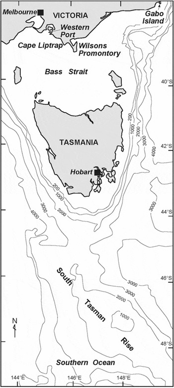
Mill Rise, a north-west/south-east feature, (approximately 44–48°S and 146–151°E) is now referred to as the South Tasman Rise with variations of ridge or plateau in some publications (Fig. 7). Part of this area (45–46°S, 147–150°E), as described in the Commonwealth of Australia Environment Protection and Biodiversity Conservation Act 1999, is now the South Tasman Rise Commonwealth Marine Reserve and has been assigned the IUCN category of managed resource protected area for the purpose of protecting and maintaining biological diversity (Bashir Reference Bashir2007). For decades, waste jarosite from the zinc factory on the River Derwent, Hobart, was shipped just beyond the continental shelf and dumped. The practice ceased when Australia ratified the London Dumping Convention (Zann and Sutton Reference Zann and Sutton1996).
Map of southeastern Australia, marking sites referred to in Davis’ notes and the South Tasman Rise discovered by Davis. Modified, with permission, from Australian Hydrographic Service Chart AUS 4601 Tasman Sea – New Zealand to South Eastern Australia. Not to be used for navigation.

On 26 December 1912, Davis left for Antarctica intending to collect Mawson and his men at Commonwealth Bay, then Frank Wild and his Western Party on the Shackleton Ice Shelf, before returning to Australia. Mawson had not yet returned to base from his far eastern sledging journey that claimed the lives of Ninnis and Mertz (Mawson Reference Mawson1915). With most of the men aboard, Davis left to get Wild and his group at the Western Base before the seasonal formation of sea ice hampered that operation. Mawson returned alone. A message requesting its return was sent to the ship, but weather conditions forced Davis to leave Commonwealth Bay. Mawson, with a small group who had remained at the hut to wait for him, was consequently obliged to endure a second winter there. They were rescued after Davis secured extra funding for the relief voyage the following southern summer.
Davis published the results of oceanographic observations conducted on Aurora (Davis Reference Davis1913, Reference Davis1939) and sent a copy to Richard in Monaco, from where several items of necessary equipment had been sourced. In The Home of the Blizzard he outlined the equipment and methodology used during the 1911–1914 expedition, with a brief reference to his voyage on Endeavour.
Endeavour had continuing links with the AAE. After the declaration of World War I, it was sent to Macquarie Island (54° 30′S, 158° 50′E) to effect the changeover of meteorological officers. Dannevig went too, taking the opportunity to extend his range of observations. After leaving the island on 3 December 1914, in fog so thick that the shore party could not observe the departure, Endeavour and all aboard, including a member of the AAE, Tasmanian biologist C.T. (Charles) Harrisson, disappeared. Since their arrival in North-east Bay on 29 November 1914, they had experienced rough weather (Cumpston Reference Cumpston1968). Meteorological reports record a heavy gale in the vicinity on 5 December. When Endeavour had not returned to Hobart by 15 December, search vessels were despatched. Werribee left Melbourne on 17 December and continued to search until February 1915. Grantala searched from 29 December until the following February and a New Zealand ship, Tutaneki, searched the seas around Stewart Island and the Auckland Islands with no sighting (Court of Marine Inquiry 1915).
Kenneth Harrisson later claimed that his brother Charles, having undertaken previous voyages on Endeavour, worried about the vessel's seaworthiness and that he had taken out a life insurance policy the day before leaving Hobart on that last fatal trip, something he had not done when travelling south with the AAE on Aurora (Harrisson Reference Harrisson1915). Charles Harrisson's daughter wrote that the ship may had struck a submerged rock which has since been charted (Harrisson Reference Harrisson1972). Recent charts reveal numerous rocky threats, some protruding, others submerged, in the previously unsurveyed seas around Macquarie Island. These were presumed responsible for many shipwrecks. An inquiry into the disappearance of Endeavour found that the ship had left Melbourne in seaworthy condition, well manned and with sufficient supplies, life saving appliances and equipment (Court of Marine Inquiry 1915).
Davis volunteered for active service during World War I and in December 1914, when Endeavour disappeared, was taking Australian troops and horses to Egypt on Boonah or Transport A36 (Davis Reference Davis1962). After learning of the tragedy, he wrote to his father: ‘It is a great pity they attempted this trip as the Endeavour was a very small vessel for the seas one gets down south of Tasmania’ (Davis Reference Davis1915).
Conclusion
The centenary of the AAE 1911–1914 will prompt a series of publications, re-examining relevant events and personalities. John King Davis (1884–1967) earned his place in Antarctic history. He was a young captain in 1911–1914, keen to adopt new technology and to contribute to the AAE's oceanographic programme. His discovery of the South Tasman Rise was to represent an important delineation of Australia's maritime area and ultimately its Exclusive Economic Zone. An excellent representation of this is given in the Australian submission to the Commission on the Limits of the Continental Shelf for Exclusive Economic Zone delimitation (Australia 2010).
His priorities were the safety of the ship and the safety of the men aboard. When confronted with dangerous situations, he was decisive, and men owed their lives to unpopular decisions he made. Following his Antarctic voyages and his wartime service, Davis was Commonwealth Director of Navigation from 1920 until his official retirement in February 1949, after which he kept in contact with his network of Antarctic associates, including Mawson, and maintained an active interest in Antarctic matters with Australian National Antarctic Research Expeditions (ANARE). Biased comments, selectively reproduced, have perpetuated an unflattering image of Aurora's captain, but a comprehensive reassessment, to which these personal notes can contribute a little additional insight, would indicate that he deserves greater understanding and greater acknowledgment for the significant contribution that he made to the success of the AAE.
Acknowledgements
The correspondence, notebooks and photographs, from which much of this paper is derived, are held in the John King Davis Collection at the State Library of Victoria, Australia. Research was also conducted at the Mawson Collection, South Australian Museum; the Mitchell Library at the State Library of NSW; the Australian Antarctic Division in Kingston, Tasmania and the Killer Whale Museum in Eden, NSW. We gratefully acknowledge the generous assistance given by many librarians, archivists and curators at these institutions.
Additional information was supplied by the NSW Department of Primary Industries (Far South Coast Fisheries), the National Archives of Australia (Canberra), the Eden Access Centre, the Map Library in the Hargrave Andrew Library at Monash University (Melbourne) and the Musée Océanographique, Monaco. We are very grateful to all staff in these institutions who supplied valuable information.
We thank the Australian Hydrographic Office for giving permission to reproduce modified versions of the maps of Twofold Bay and the South Tasman Rise and Ms June Pongratz for the final result. We also thank our referees for their very helpful comments and Mr John Williamson for the initial proof reading. Special thanks go to the copyright holders of the estate of John King Davies who gave permission to publish the text of his notebook, and to staff at the State Library of Victoria for facilitating the process that enabled publication of the notebook and photographs of John King Davis.