



Dedicated to my friend Lodewijk Hulsman (1950–2016)
The loss of Brazil to the Portuguese in 1654 favoured the resettlement of Dutch merchants along the Wild Coast and in the Antilles and the formation of new colonies. One such colony was Cayenne, which the Dutch settled in 1655, as it had been completely abandoned by the French in December 1653.Footnote 1 The so-called Ile de Cayenne, or Cayenne Island, was first occupied by Jan Claes Langedijck at Cépérou (Cayenne) and somewhat later by David Nassy, who settled eventually at the opposite part of the island at Armire (Rémire). Although these two Amsterdam-based WIC colonies did not get along very well in the beginning, they probably depended on each other, until the two short-lived enterprises were taken by the French in May 1664.
The French interest in the Dutch twin-colony was most certainly due to the Jewish presence in Armire, where a Sephardic community had constructed sugar works and brought African slaves to produce sugarcane and sugar. From the late 1630s onward the French government had been sidelined from the Antillean sugar boom by the seigneurs-propriétaires of the French Antilles and was unable to fully profit from the development of this valuable product.Footnote 2 Meanwhile Dutch merchants, most of whom had been working in Brazil, had obtained land in Guadeloupe from its French governor, Charles Houël. They brought investors, sugar works, and African slaves to the island, creating prosperity after a number of failed sugar attempts.Footnote 3 It is advocated here that the French interest in Cayenne was mainly guided by an interest in acquiring the sugar works of the young but prosperous Sephardic colony in Armire and, to a far lesser extent, by the geopolitical importance of the conflict between France and the Dutch Republic, which eventually exploded during la Guerre d'Hollande (1672–1678).
This paper presents first a general description of the first decade of the second half of the seventeenth century, followed by a detailed description of the two Dutch colonies based on fresh archival research in Amsterdam and The Hague, as well as documents presenting Jan Claes Langedijck and David Nassy as key figures of these colonies. A few French documents, such as those written by Jean Goupy and Jean-François Artur, only refer to the Jewish colony of Rémire,Footnote 4 but reveal the importance of the Sephardic presence for the embryonic French colony.Footnote 5
The French West India Company
The French West India Company was founded to oppose the English and Dutch naval and commercial dominance in the Lesser Antilles. The English under Cromwell had passed the Navigation Act of 1651 to protect their colonies from Dutch merchants by restricting shipping. King Louis XIV and Jean-Baptist Colbert decided to nationalise their colonies in order gain more political control, but also to obtain more economic profit from the colonies and notably the sugar trade, which was booming in the Antilles in the second half of the seventeenth century.Footnote 6
The Dutch traders had to be rooted out as they damaged the national interest and hampered the economic growth of French traders and ports.Footnote 7 The situation however was ambiguous: the Dutch success was also instructive for the French, as shown by a memoire of the Secrétariat d’État à la Marine found among the papers of Adrien Dyel Vaudroque, the governor of Martinique.Footnote 8 This document, dated 1661, detailed how the French had analysed the Dutch commerce in the Antilles and along the Wild Coast and showed why it was better for the French state to occupy the French islands instead of establishing colonies on the mainland, notwithstanding the costs of the freight and the purchase of slaves.Footnote 9 In spite of this good advice, the French continued to prepare a new company for the Cap du Nord, as they called the coast between the mouth of the Amazon and Suriname Rivers.Footnote 10 This company had two objectives: the first was to conquer or built a fortress on the mainland; the second, to control the commerce in that area. In order to do so, both a large military force and privileges in growing tobacco and sugar production were needed. It was believed that the planters preferred to sell their products to the Dutch because French “taxes on tobacco and sugar were so high that nearly all French merchants sold their sugar to the Dutch, hereby ignoring Dieppe and ruining their own refineries in Rouen.”Footnote 11
In early 1663, parallel to the preparations of the Cap du Nord and the Compagnie des Indes occidentales (French West India Company), Joseph-Antoine Reference LefèbvreLefèbvre, sieur de La Barre, Bouchardeau, who had been several times in the Americas, and Charles-Jean Colbert du Terron, cousin of Jean-Baptist Colbert, started a company called La Nouvelle Compagnie de la France Equinoxiale en Terre Ferme de l'Amérique.Footnote 12 When they presented their plans to Jean-Baptist Colbert, however, they discovered that the king would not allow private colonies anymore. Instead they could join Lord de Tracy on his maiden voyage to Cayenne and subsequently to the Antilles to take over all French possessions for the king.Footnote 13 That same year the Comte d'Estrades, the new viceroy of the Americas and the former French ambassador in the Dutch Republic, urged the French king to act quickly.Footnote 14 Finally, the fleet left France 26 February 1664.Footnote 15
The Dutch were aware of the plans for the French West India Company (eventually founded 28 May 1664), but only got wind of an attack on Cayenne in January 1664, about a month before the French fleet left Le Havre de Grace.Footnote 16 The Dutch ambassador in Paris, Jacob Boreel, got hold of intelligence about a “large French fleet” heading for Cayenne. The States-General were worried about this large fleet as they were not able to send out supporting forces to help the Cayenne population to fight the French if they would attack “against right and reason.”Footnote 17 In this matter the States-General asked the king of France to spare the Dutch settlers and to leave the WIC plantations undisturbed. However, the king replied that he wanted to gain control of Cayenne, as was discussed in the States-General one month later. In fact, France claimed Cayenne as their prime colony on the Wild Coast despite the failure of their previous attempts (see below). This argument apparently raised some eyebrows as the States-General concluded that (1) the island was not occupied by Christians when Langedijck arrived, (2) the French were not welcomed by the Amerindians as they had lured them onto their ships and sold them as slaves in the Antilles, and (3), that there was no effort to reoccupy the colony with Antillean settlers. In the end, the States-General noted that the WIC would accept cohabitation at Cayenne and concluded the meeting.Footnote 18 In fact, this is what happened and probably what the French had hoped for. The surrender of Cayenne went smoothly without any gunfire or casualties, as explained by Jean-Christophe Chalon, notary on board the French fleet taking over Cayenne.Footnote 19 The Dutch and the French signed a treaty on 15 May 1664 consisting of various articles and conditions regarding both colonies on the island.Footnote 20 Everybody was allowed to stay in Cayenne or surroundings, or to sell their property and leave without constraints.Footnote 21 Many left, while others who stayed were chased out or deported by the English three years later, in 1667.
Cayenne Island
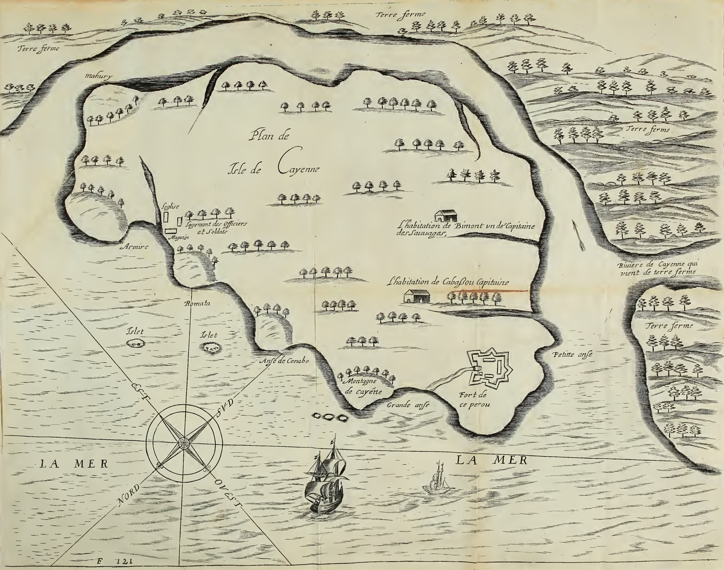
The French had left Cayenne by the end of 1653, and the Dutch merchant Jan Claes Langedijck received a patroonschap Footnote 22 (patronship) in 1655 from the Amsterdam chamber of the WIC to start a colony in Cayenne (figure 1). He became governor for the WIC and was replaced in June 1663 by Quirijn Spranger, the governor who eventually handed over the colony to the French.Footnote 23 This colony was situated at the northwestern tip of Cayenne Island at the mouth of the Cayenne River. This island is marked by large table mountains in the hinterland and along its coast, of which the Mahury is the most prominent mountain in the east, marking the mouth of the Wia or Mahury River. These mountains attracted numerous voyagers, notably Hollanders, Zealanders, and Normands, in the first decades of the seventeenth century. The fort there was probably built by Norman traders in the early 1630s on a small hillock, most often called Cépérou by the French. Normands and Zealanders, of whom Jacob Bontemps and Jan de Moor are probably the best-known merchants, maintained rather small plantations in the vicinity of Amerindian villages for victuals and trade in hammocks (cotton), dye wood, annatto, and tobacco.
Map of Dutch Cayenne Island

In 1652 the Normand traders led by Jacob Bontemps received heavy competition from a Parisian-based trading company who wanted to take over Cayenne under the command of Father Marivault and Etienne Roux, sieur de Royville. Unfortunately, the former managed to kill himself before departure and the latter was killed during the Atlantic crossing.Footnote 24 The remaining personalities, including Sieurs Bragelonne, Duplessis, Vertaumon, and Le Vendangeur, probably all with double agendas, settled separately at Cayenne. Bragelonne and Duplessis settled in the bay of Armire at the foot of the Mahury mountain, whereas Vertaumon settled at Fort Ceperou (figure 2). Disputes and starvation among the settlers (more than four hundred men were taken to Cayenne) and continuous warfare with the local Caribs (or Galibi) made the French eventually leave in December 1653.
Detail of an anonymous map of Cayenne Island, ca. 1652. It shows the French hamlet of the 1652 expedition founded by Duplessis and Bragelonne, where Nassy and company eventually settled in 1660. Published in Reference LaonLaon, Relation du Voyage, 120.
Langedijck took advantage of this departure as he probably heard of their departure when French posse arrived at Barbados. He had traded with the Amerindians of Cayenne long before the French 1652 expeditions as a factor on Barbados.Footnote 25 He settled at the foot of the Ceperou hillock and received his patronship in 1655, as the WIC was desperately looking for new opportunities in the Americas after the loss of Dutch Brazil. Four years later, the WIC granted a second patronship at Cayenne to David Nassy. After heavy quarrelling with Langedijck, Nassy settled in the hamlet of Armire, where the French had abandoned their settlement and plantations in 1653.
When Joseph-Antoine Lefèbvre, sieur de La Barre, and Alexandre de Prouville de Tracy arrived at Fort Ceperou (baptised Fort Nassau by the Dutch) in May 1664, it was occupied by a few hundred Dutch and Jewish settlers and African slaves managing a few sugar estates and trading with the Amerindians. The working population was barely armed and there were no military forces or soldiers on the island who could properly defend the colony. Indeed, there was little Dutch resistance, and after five days of negotiations a treaty was signed between Quirijn Spranger and de La Barre. This treaty stipulated that all settlers, Jews included, were allowed to stay on Cayenne Island to continue their business or leave and sell their belongings, as suggested to the French king by the States-General. Many Dutch sold their plantations to the French Company and left Cayenne. This is well documented in the case of Governor Spranger as he sold Langedijck's belongings to the new French governor de La Barre.Footnote 26 It is believed that Nassy left too and sold his plantation (with watermill)Footnote 27 to the French West India Company, but the majority of the Jews apparently stayed and continued to produce sugar under French rule. Unfortunately, in 1667 the Jews were all taken away by the English and shipped to Suriname.Footnote 28 This English attack is regarded as retaliation for the combined Dutch and French pillaging raids in the Lesser Antilles during the Second Anglo–Dutch War and drained the young French colony of its most important assets.
Despite this loss the French were cordial regarding the ruined Jewish and Dutch planters who were now deprived of their plantations, recalling the stipulations in the 1664 treaty. In 1668, French governor de La Barre went to Surinam to visit the new Zealander governor Crijnssen. de La Barre had granted some Dutch permission to leave Cayenne but, more importantly, he went to Suriname to buy the abandoned Dutch plantations caused by the English attack. These plantations were taken over by French planters, most notably the fine, large plantation of Abraham Drago, which was taken by the newly installed Jesuits, who baptised it Loyola.Footnote 29 It can be noted that, under Jesuit rule, this former Jewish plantation became the most important plantation of modern French Guiana.Footnote 30
Jan Claes Langedijck
The Langedijck brotherhood represented merchants in Amsterdam.Footnote 31 In 1643, Jan Claes traded with Nieuw Nederland (now New York) and about ten years later he was a factor on the island of Barbados,Footnote 32 from which he visited the Wild Coast, notably Cayenne, to procure wood for the booming sugar industry.Footnote 33 For this matter, Langedijck asked for a patronship on the Island of Cayenne, which was granted by the chamber of Amsterdam in 1655.Footnote 34 Langedijck himself declared he had received this patronship on 30 August 1655, as well as a commission on 27 April 1656, both from the Amsterdam chamber.Footnote 35
In 1656, Langedijck boarded the Witte Fortuin, commanded by Pieter Visscher Sijbrandtsz d'Enkhuizen, to sail for Cayenne and start his colony. He took thirty to forty colonists but no military men. In fact, Langedijck had apparently established a healthy relationship with the local Amerindians who, as Langedijck was told, had been lured into the ships of the French to be transported to the Antilles and sold there as slaves.Footnote 36 In 1657, Nicolaes Langedijck, the brother of Jan Claes, accused Visscher (who had returned to Amsterdam) of not having executed correctly the contract he had signed with Jan Claes Langedijck, because he had to stay in Cayenne.Footnote 37 Visscher, however, asked his shipmates to defend him and recorded several declarations revealing he had loaded the ship with wood in three weeks and that the Indians helped with building a house and clearing some forest to make gardens for the colonists, for which the Indians received a few knives and axes. The shipmates also added that at the time of departure Langedijck kept “a batch of this ironware of the pilot,” which provoked a misunderstanding.Footnote 38
In 1658, Langedijck returned to Amsterdam, where the Lords XIX renewed his patronship.Footnote 39 He signed another contract for Cayenne in 1659 with Jean Vignon to transport forty colonists in the Vergulde Vos, commanded by Hendrick Andriesz Backer.Footnote 40 That same year, actually two days after he had signed the former contract, the chamber of Amsterdam signed two other contracts. The first was with Langedijck, who ceded his patronship to the chamber of Amsterdam; in exchange, the latter would pay Vignon as well as the entire expedition.Footnote 41 The other act is very similar but also contains a listing of the titles obtained by Langedijck and his patent.Footnote 42 This act acknowledged the private property of Langedijck as well as that of the colonists, situated at the foot of the small hillock called Cépérou where the French had built their fortress, now transferred to the WIC.Footnote 43
The contract between Vignon and Langedijck also stated that the latter would not only assure colonists for the colony, but also that he would pay Vignon in advance for the Atlantic voyage. The Dutch historian Van Grol suggests that Langedijck was forced to transfer his titles to the WIC of Amsterdam because he had not managed to raise sufficient finances and colonists.Footnote 44 The financial problems are confirmed by a letter Langedijck wrote to the Amsterdam chamber of the WIC in which he explained that he was not able to convince the private investors and that his personal financial status was insufficient to carry out the voyage; hence, he was obliged to ask for WIC aid.Footnote 45 The established contract showed that Langedijck would pay for the expenses of the voyage and it is highly possible that the WIC would have helped him by mobilising orphans, evidence of whom appears in Cayenne later on.Footnote 46 Eventually, Langedijck continued his project in Cayenne, but now in the service of the directors of the WIC in Amsterdam.
As a director, or commandeur, Langedijck had to supervise the contracts between the colonists and the WIC. For instance, in the contracts between the WIC and David Nassy as well as the Nieuwe Guiaansche Compagnie (NGC) is a condition stipulating that the African slaves must stay at Cayenne and that they cannot be transported or sold.Footnote 47 One may believe that the WIC was now convinced, after the loss of Brazil, that her principal interest was the African slave commerce and that she had decided to defend her monopoly. It is remarkable that there are no documents mentioning the presence of land surveyors to delimit terrain or solicitors to register properties. These services were among Langedijck's responsibilities when he had obtained the right of property at Cayenne.
The Vos transported Langedijck and his colonists to Cayenne in 1659.Footnote 48 Later declarations show that the situation was rather problematic at Cayenne, because two other Dutch expeditions were organised in the same period. The first expedition travelled aboard the St Jean Evangelist, armed by Balthasar Gerbier, which arrived in January 1660, just after Langedijck's arrival. Gerbier brought a large number of colonists with him, but also a few NGC miners to verify the existence of silver mines to the east of Cayenne. In fact, Gerbier and the NGC both signed an agreement with the Amsterdam WIC to explore silver mines between the Oyapock and Approuague Rivers at what is called today Montagne d'Argent.Footnote 49 A second expedition was led by David Nassy, who had also received a patent and arrived that same month on the Land van Belofte and Abrahams Offerande, also bringing with him many colonists (see below).Footnote 50
In 1663, the directors of the WIC in Amsterdam replaced Langedijck with Quirijn Spranger to direct the colony.Footnote 51 French and Dutch literature seldom speak of Jan Claes Langedijck and refer principally to Quirijn Spranger as founder of the Dutch colony in Cayenne.Footnote 52 This is the case among many historians such as Hartsinck and Father Labat, but also more recent studies such as Panhuys.Footnote 53 Nonetheless, Langedijck was the founder of Cayenne and Spranger only arrived in 1663.
Spranger was the son of Michiel and Elisabeth Spranger.Footnote 54 This solid Amsterdam-based family had important ties with cities such as Antwerp and Prague. Spranger was the secretary of Johan Maurits of Nassau in Dutch Brazil, and after his return to Holland in 1644, Spranger continued to trade in Brazil.Footnote 55 He continued trading there until the Dutch surrender of Recife to the Portuguese.Footnote 56 In 1656, Quirijn Spranger went back to Amsterdam.Footnote 57 He continued in business with the well-known Sweers brothers, whom he knew from Brazil,Footnote 58 but also with Abraham Cohen, one of the investors of David Nassy. Unfortunately, the deliberations of the directors of the Amsterdam chamber are missing for this period and there is no information available about the replacement of Langedijck by Spranger. It is suspected however that it would have been a rather delicate case because of the tensions and perhaps rivalry between Langedijck and Nassy in Cayenne. Spranger probably suited the directors better because he had good relationships with Abraham Cohen.
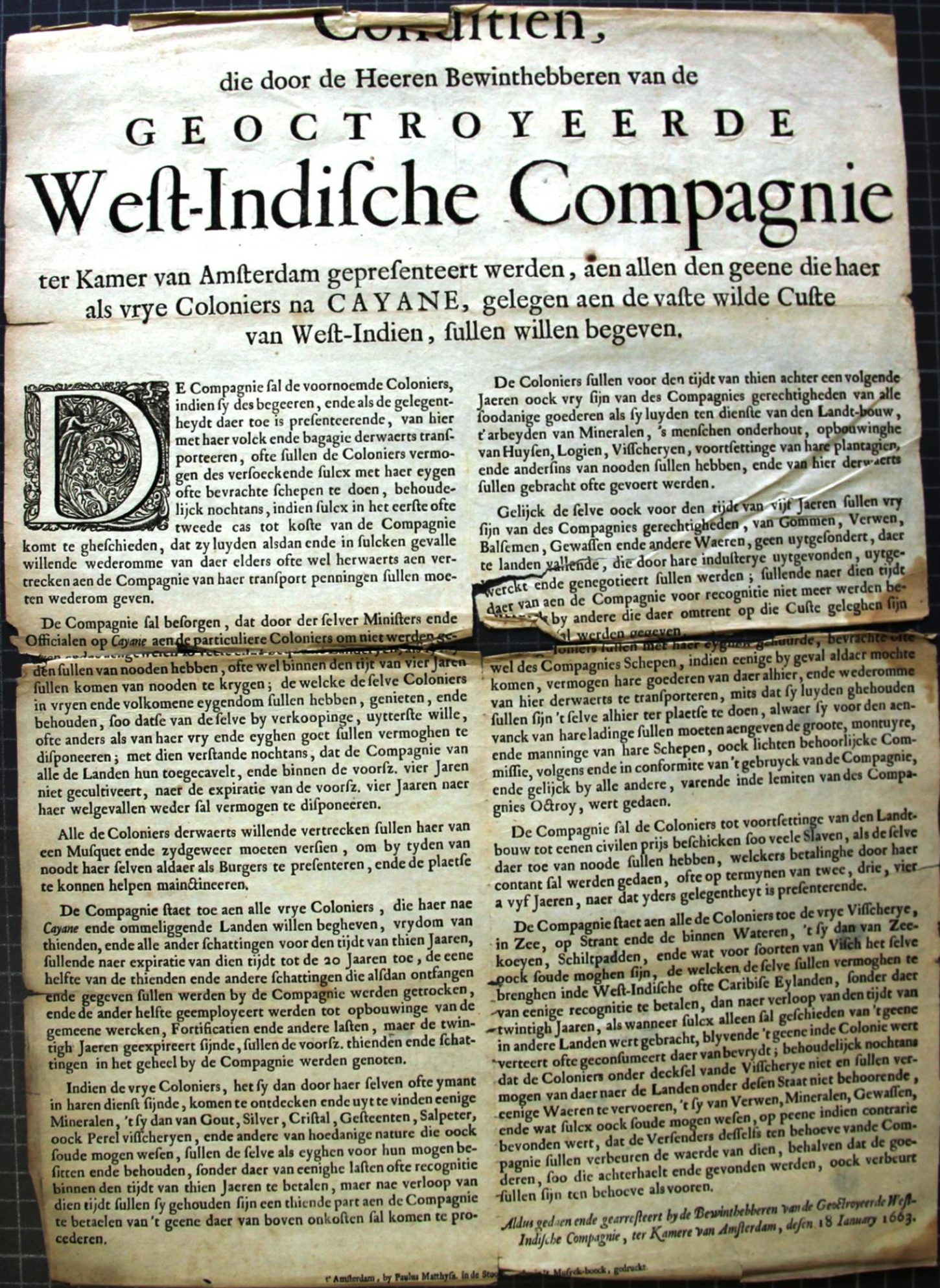
In 1663, the directors of the WIC launched a new effort to stimulate the prosperity of their Cayenne colony by exempting the colonists from taxes for ten years (figure 3).Footnote 59 This seems to have proven fruitful because Spranger, the incoming commandeur of Cayenne, brought about 190 colonists with him.Footnote 60 Among them was one Goossen van Vreeswijck, a specialist in mining matters.Footnote 61 The Vos arrived in Cayenne in June or July 1663 and once the passengers had debarked, Langedijck boarded and travelled to the Antilles and Nieuw Nederland before arriving in Holland.Footnote 62
Edict (plakkaat) published 18 January 1663 by the directors of the WIC chamber of Amsterdam to invite colonists to settle in Cayenne (NL-HaNA 1.11.03 39, document 4).
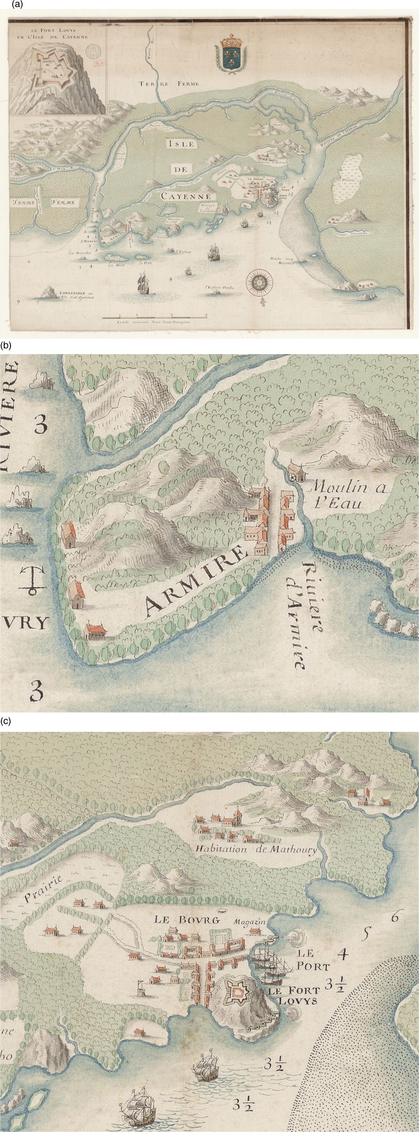
Langedijck and Spranger were embroiled in a sad affaire because the latter, as director of the colony, had sold most of Langedijck's property to the French when they had taken Cayenne. Spranger solicited three witnesses to show he had appropriated Langedijck's terrain legally, including the movables and slaves (figure 4). According to the declaration made by Bastiaen Miljou from Paris, who was the interpreter during the negotiations between Spranger and French governor de La Barre, Spranger had taken (1) a double-floored house standing at the foot of the fort, (2) a few plantations situated around the same fort, (3) a plantation at “Matterij” [Matoury or Macouria ?] situated in the savannahs near the mouth of a creek marked by a Green rock (Groene klip),Footnote 63 and (4) all utensils belonging to the plantations. Spranger would also have employed the African slaves for his own use until the arrival of the French in May 1664 and the surrender of the fort. French documents showed that Spranger had sold a beautiful plantation, situated in Matoury, comprising ten buildings and thirty-two slaves, to de La Barre for 14,000 florins.Footnote 64 It is suspected that Langedijck went back to Amsterdam against his will, and his hard feelings can be felt when reading the above mentioned declarations.Footnote 65 He lost the case, and Jan Claes Langedijck evaporated from Dutch colonial history.Footnote 66
(a) Map of Cayenne Island drawn by M. Mel in 1665, published in de La Barre's 1666 Description de la France equinoctiale, 10 (see also FR-BnF DCP GE SH 18 PF 164 DIV 5 P 4). (b) Detail of the town of Armire and (c) detail of Cayenne. This map roughly reflects the two Dutch colonies after the take-over.
The Sephardic Enterprise
David Nassy, or Nassi, who received his patronship from the Amsterdam chamber of the WIC on 12 September 1659, was without doubt the main character of the second Amsterdam enterprise.Footnote 67 David Cohen Nassy was born in 1612 and used various pseudonyms, such as Cristovão de Távora (his Christian name) and José Nunes da Fonseca (his commercial name). Nassy fled the Inquisition in Portugal and went to Amsterdam. He married Ribca, or Rebecca Maria Drago, who gave birth to twelve children. Nassy lived in northeastern Brazil during the Dutch occupation (1630–1654) where he conducted commerce for the WICFootnote 68
The failure of the WIC in Brazil forced Nassy, as well as many other merchants, to look for new opportunities. From 1650 onwards, he was already active as an entrepreneur in various commercial enterprises in the Antilles. For instance, he had obtained concessions for starting a sugar plantation in a new colony called Nova Zelandia to be founded at the Pomeroon River, situated to the north of the existing Essequibo colony of the WIC. His prosperous business along the Guiana Coast and the Antilles is in fact a good example of the commercial activities that developed in these parts of the Americas, to which Cayenne can certainly be included.Footnote 69 Nassy's activities can also be ascribed to the general reorientation of the commercial politics of the Sephardic community during the second half of the seventeenth century, notably after the failure of the Dutch colony in Brazil.Footnote 70 Two of Nassy's main investors were Abraham Cohen and Antonio Luis Cohen, both from Amsterdam.
Abraham was also active in various enterprises in Dutch Brazil, in Nieuw Nederland, and in the Lesser Antilles.Footnote 71 This rich merchant from Pernambuco claimed compensation for his former property in Brazil from the Portuguese government for an amount of 137,871 florins.Footnote 72 As mentioned above, Abraham Cohen was also acquainted with Quirijn Spranger, as indicated by a 1655 declaration showing he had taken merchandise from Spranger coming from Recife in 1651.Footnote 73
Antonio Luis, Nassy's other main investor, is the only one who had never been to the Americas. He was born in Paris in 1624 and had settled with his parents in Bayonne.Footnote 74 Before 1641, Luis conducted large-scale commerce in Porto, Portugal. After the rupture between Portugal and Spain he returned to Paris, where he lived a few more years before moving to the Dutch Republic in 1648. He participated in various enterprises involving the Atlantic region.Footnote 75 He established important ties, notably with Bento Osorio, one of the most important Jewish merchants in the Netherlands, who vouched for him during a process at the Court of Holland.Footnote 76 Antonio and Abraham were both involved in the slave trade.Footnote 77 It is interesting to note that Luis hoped to found a colony at the Sinnamary River, but this project never was realised.Footnote 78
However, David Nassy's most important commercial partner must have been Abraham Drago. It is certainly possible that Abraham was a cousin of Isaac Drago, who had married Nassy's daughter Sara. Drago was born in Lisbon in 1628 and had arrived in Recife in 1648, probably passing through Amsterdam first. He was also one of the first Jews to settle in Curaçao in 1651, although he went back to Amsterdam in 1655, where he died in 1697.Footnote 79 It seems evident that the Nassy and Drago families were intimately connected and that they played a central role in the history of the Jewish colony at Cayenne Island and, more generally, in the Jewish migration to the Antilles during this period.Footnote 80
The WIC, facing bankruptcy, was eager to induce the Jewish merchants to invest their money in the foundation of colonies in Guiana along the Wild Coast, where they were offered the monopoly on the trade of African slaves. Nassy and his investors received exceptional privileges for their colony, as stated in the patent of David Nassy, issued on 12 September 1659 by the directors of the WIC. It included for example jurisdiction over the bays and rivers of Cayenne as well as the hereditary possession of the cultivated territory during the first four years.Footnote 81 This patent can be compared to a feudal property.Footnote 82
This concession stipulated that the Jews would have the right to exercise their religion in a synagogue and that they could instruct their children at school.Footnote 83 They benefitted furthermore from a tenth tax exemption for twenty years, the right to keep discovered minerals, and the exemption of taxes to transport necessities by sea. The exportation of natural products, such as gums and dyes, was exempted from export taxes for a period of five years. Nassy was allowed to charter ships, but was obliged to use the WIC for shipment and pay all licences necessary; however, he had no right to export his products to Europe.
Nassy's enterprise was a company divided in six parts of 3,000 florins each. The known stakeholders were David Nassy, Abraham Cohen, Antonio Luis, Abraham Henriques Flores, David Dias Anthonis, and Abraham Rodrigues Prado.Footnote 84 In May 1660, Cohen transferred his sixth part of the colony of Rémire to Luis, showing that his WIC patent and company stakes were transferable.Footnote 85 Nassy and Luis bought Prado's sixth part and acquitted in this manner the debt of 1,200 florins from Prado, Cohen, and Luis. Subsequently, Luis and Nassy signed a contract with Abraham Nuñes d'Espinosa, son of Abraham Rodrigues Prado. In this manner, Espinosa could settle in Cayenne and collaborate with Flores, Antunes [sic], and Isacque Drago, the other proprietors; they were allowed to cultivate the soil altogether with twelve slaves each.Footnote 86
After transferring his part in the Rémire colony, Cohen centred his activities in Essequibo. His will suggests that he might have found himself in a delicate situation regarding both health and commerce.Footnote 87 Apparently, Isaque Drago, son-in-law of Nassy, also became a stakeholder of the colony, but we did not find any traces of this particular transaction in the Amsterdam city archives. Prado's transportation act is interesting because it shows that the stakeholders had established a treaty to delimit their property. The WIC patent also stated that the patrons should cultivate the soil in the new colony for a period of three years.Footnote 88 The distribution of the land in various terrains in Rémire was determined by the cultivated surface realised by the stakeholders; the surface apparently being limited by the number of slaves to be employed.
In September 1659, Nassy signed a contract for the delivery of 114 African slaves by the WIC. Another document, however, suggests that fifty-two slaves were paid for previously by Abraham Cohen.Footnote 89 In the 1659 contract, Nassy was authorised by the WIC to buy horses and cows at Curaçao for his colony, which was accepted without problem following his patent.
In 1663, he signed another contract with Joris Govertsz from Rotterdam, captain of the Viscorff, who was sailing to the Antilles, calling at Cabo Verde and Cayenne. Once he arrived at the latter colony, the ship had to be equipped for catching manatees, whose meat would be sold again in Surinam and the Lesser Antilles. Eventually, the ship would return to Amsterdam by either calling at Cayenne (again) or Bonaire.Footnote 90
In 1659, many Jewish settlers from Portugal and the Dutch Republic left for Cayenne with the vessels Het landt van Beloften and Abrahams Offerande, commanded by Nassy.Footnote 91 They arrived in January 1660.Footnote 92 Two other ships, the Stad Hamburg and the frigate Abrahams Offerande, arrived a bit later with more settlers.Footnote 93 This massive arrival provoked much conflict with Jan Claes Langedijck, who refused them access to Cayenne in order to protect the interests of his own colonists.
On 10 May 1660, shortly after his return to Amsterdam, Cornelis Fransen, captain of the Abrahams Offerande, declared that Langedijck had indeed refused permission to the passengers to set foot at Cayenne. He also stated that the colonists of the Balthasar Gerbier expedition, who had left the Approuague River, had damaged various sugarcane fields at Cayenne, for which Langedijck held the Jews responsible.Footnote 94 In the meantime, Langedijck had also issued a rule that nobody could leave Cayenne before new orders were given by the directors of the WIC under penalty of a fine of 2,000 florins. Accordingly, Langedijck had ordered to unload the cargo of a Jewish ship, which was already loaded for the return voyage to the Netherlands.Footnote 95
The declaration of Francisco van Dalen provides additional and more precise information on the arrival. He stated on 4 May 1660 that Langedijck had asked Gerbier for 2,000 florins for the damage inflicted to the sugarcane fields by Gerbier's colonists, who had been at sea for at least three months. Van Dalen also stated that Nassy's colonists had shown Langedijck the contract in which the WIC directors attributed terrain to them on Cayenne Island. Nonetheless, he continued, Langedijck had refused to give them land because, according to the latter, it was against the interests of his own colonists. Nassy's colonists were thus obliged to seek retreat on the mainland, but they found the soil there rather bad. Van Dalen also stated that Cayenne Island measured six leagues in circumference and that Langedijck only had thirty to thirty-five people on site, the majority being boys, and not more than twelve craftsmen. This point revealed that Langedijck's colony consisted mainly of indentured labourers and orphans. Whether Langedijck produced sugar with African slaves is unknown but, according to French sources, there was at “Jambon” near the town of Cayenne a Jew called “Vermeille,” being the first to make sugar in Cayenne.Footnote 96
Van Dalen also said that Langedijck had barely planted anything with the exception of a place situated at a quarter league from the fort, which was dedicated to the cultivation of victuals. He continued by underscoring that the settlers demanded Langedijck refuse access to the Jews and that they threatened to leave him or even to kill him if he did not do so. Finally, Van Dalen declared that the Amerindians had a very good relationship with the Jews and with Langedijck.Footnote 97 He explained that the latter had dispatched four to five Amerindians to the surrounding forests in order to prepare more gardens for cultivation. Apparently this was ordered in secret by Langedijck to justify his presence on Cayenne Island, but also to obstruct Jewish settlement.Footnote 98
In July 1660, the ship St Mattheus arrived, probably with new orders from the WIC directors corresponding to the complaints lodged by the Jews in Amsterdam. Langedijck was overruled and forced to provide land on Cayenne Island to Nassy's settlers,Footnote 99 mainly distributed in the vicinity of Rémire.Footnote 100 It seems clear now that Nassy's colony at Rémire functioned independently from the colony directed by Langedijck, situated in the surroundings of Fort Nassau; however, after this difficult start, both colonies certainly had legal and illegal contact and exchange with each other, despite the lack of information to sustain this hypothesis.
The French Take-Over
Little information is available concerning the period between 1660 and 1663, but it is believed that numerous voyages were destined for Cayenne.Footnote 101 For instance, Captain Paul Languillet visited Cayenne multiple times and brought slaves there.Footnote 102 He stated that there were about “15 to 20 jewish families at Hermire working the land”Footnote 103 (figure 4). The Amsterdam city archives contain a contract dated 1660 between the Drago family (Abraham Drago) and Gabriel Lavella (Level) to cultivate land with slave labour at Cayenne. The presence of Lavella at Cayenne is indirectly attested by a declaration, dated 1664 in Amsterdam, concerning the behaviour of the minister Coningxvelt.Footnote 104
Dutch sources attributed to the French occupation of Cayenne after May 1664 are also limited, but first of all we can point out the accusation made by Abraham Drago against the captain of ‘t Wapen van Hoorn who refused to enter the bay of Cayenne when he heard of the French take-over of the Dutch colony. According to Drago, the captain carried important documents with him to be handed over to David Nassy. In November 1664, Drago called on the witness Isacque Velho who was contracted by Lavella to work in Cayenne.Footnote 105 Although the latter was more likely to be in service for Drago, he declared that the ship had made anchorage at large of the mouth of the Approuague River and that two inhabitants there had informed the captain about the changed situation in Cayenne.
In October 1665, Drago also called upon Isaac van Mildert, codirector of the NGC, and Samuel Janseris, both inhabitants of the Approuague River.Footnote 106 They were back in Amsterdam for business and made declarations in front of the NGC board of directors. They declared that they were on the Approuague River in June 1664 when they learned from the captain that the French had taken the port of Cayenne, but that the French let in Dutch ships without problems. Despite this information and the fact that he was carrying letters for David Nassy, the captain still preferred to avoid Cayenne and to continue his voyage to Curaçao.Footnote 107 Finally, Drago also called upon an inhabitant of Cayenne to confirm the existence of a letter written by David Nassy, dated 12 July 1664, as well as a letter written by Samuel Nassy, dated 6 June 1664.Footnote 108 The latter document clearly showed Drago's worries about maintaining the Jewish colony after the French take-over.
A number of Dutch historians such as De Boer, Zwarts, and Oudschans Dentz are affirmative on this matter, considering that in 1664 the Jewish colony had been abandoned and that the Jews had left for La Rochelle after the French conquest.Footnote 109 They all rely upon a short note in the Dutch journal Hollantse Mercurius from June 1664, which stated that Jews and Christians had been transported to this French port.Footnote 110 But Zwarts's affirmations, simply copied by other historians,Footnote 111 must be questioned here, as Loker did more recently: English sources mention that fifty to sixty Jewish inhabitants were still present at Cayenne when the English fleet of captain John Harman and Henri Willoughby attacked the fresh French colony in September 1667.Footnote 112 The English deported the Jews to Surinam, “with tools for about ten mills,” where they joined the Jewish colony already existing since 1661.Footnote 113
In 1664, the Dutch archives also mention a cargo of Angolan slaves aboard the ship of master Carloff, who were sold to Nassy in exchange for land at Cayenne.Footnote 114 Jean Prignon, who was probably the commandeur at the plantations of Nassy and Carloff, sold these slaves to the French governor de La Barre for 5,000 florins. This transaction, as well as many others concerning the sale of Dutch belongings to de La Barre, was coordinated by the Amsterdam-based notary and merchant Jean de La Planche.Footnote 115 Interestingly, one Jean Planchard also signed the contract in which Spranger sold the above mentioned Matoury plantation to de La Barre by means of an exchange letter.Footnote 116 The link between Planchard and de La Barre still remains unclear, but seems to be related somehow to Hendrick Carloff.Footnote 117 The latter was a poor Rostock planter who had served the Swedish African Company and the WIC in Africa.Footnote 118
The Curaçao Papers mention the arrival of Sieur d'Elbée on the St Anthonie at Curaçao in July 1664, coming from Cayenne.Footnote 119 This Frenchmen was in the fleet of de La Barre and de Tracy when they took over Cayenne and had wanted to take the inhabitants to Tobago, but arrived at Curaçao instead. He explained that the States-General had already been informed by the ambassador of France about the French motives (being the first occupant) to take over Cayenne. He also said that the director of Cayenne (Spranger) had left Cayenne in the ship Oranjenboom for Tobago eight days before he left.
The correspondence of Abraham Crijnssen, the governor of Suriname, reveals the existence of negotiations in June 1668 between Crijnssen and de La Barre, who visited Suriname concerning the remaining Dutchmen at Cayenne.Footnote 120 For this matter, a transfer was organised because John Tressry (Crijnssen being too sick) wrote that the French showed their good intentions by giving permission to the wife of one “Monsr Vermeulen” to leave Cayenne accompanied by a few slaves.Footnote 121 The Jewish case was also a point of negotiation between Crijnssen and de La Barre because in the same letter Tressy wrote that the Jews, who had been deported to Suriname by the English, had received a financial compensation for their Cayenne plantations which was ordered by the king of France himself. Tressy however esteemed this compensation to be nothing but a small sum or misery and that the whole affair was the result of “mechanisations” orchestrated by the Jesuits whom he considered masters in deceit and treason.Footnote 122 Finally, we must note the presence of a few, perhaps the last, Jews at Cayenne in June 1668, because Crijnssen evoked the arrival in Paramaribo of a ship from Cayenne with a few Jews aboard.Footnote 123 It is believed that all Jews had left Cayenne by this date; Nassy and Drago continued their family business in Suriname.Footnote 124
Conclusion
The States-General discussed the smooth take-over of Cayenne by the French in October 1664. They affirmed that they took without hesitation the entire island and the States-General deplored the fact that France never advised them of their attack, claiming that the French had simply “ripped off” two Dutch colonies to be added to their empire. The States-General continued by stating that they had lost “hundred thousands” [florins] worth of expenses, which had been usurped in “full awareness” by the French. They were also hoping that the latter would keep their word, considering the first article signed between Spranger and de La Barre, and restitute their investments quickly. The French boldly took over Cayenne as part of their new mercantilist strategy, known today as Colbertism. They paid off the Dutch and Jews for their belongings, as was demanded in February 1664 by the States-General, who were unable to defend this colony along the Wild Coast.Footnote 125
From the French point of view it was a well-prepared and successful operation to root out the Dutch in the Americas. Next to recuperating their former colony to occupy a strategic stronghold along the Wild Coast, the presence of working sugar plantations in combination with the know-how of the Jews to produce good quality sugar must certainly have been an important goal of their voyage, and a real cherry on the French pie, despite the pitiful description of the Dutch colony by de La Barre in his book.Footnote 126 The colony was easy prey and wholly left intact, ready to continue its production. The sugar industry was booming and the French were definitely lagging in this new economic branch. By nationalising the French Antilles, where the Dutch had founded many sugar plantations, and occupying Cayenne, they hoped to gain a bigger part in the sugar industry, and notably the production of sugar in the Americas. This point is clearly illuminated by the English attack in 1667, taking all tools, slaves, and Jews to Suriname, thus depriving the French of any sugar production.
The private interest of de La Barre in Cayenne and his wish to found a special enterprise to serve his interests deserves more attention. Having prepared his company for several years, he probably wished to rule Cayenne, albeit under the flag of the French West India Company (as the design slightly changed) as a family business by installing his brother Cyprien Lefebvre, Chevalier de Lézy, as governor. The private properties of De Poincy (St. Christophers), Houël (Guadeloupe), and Du Parquet (Martinique) must have served as examples during the preparations. Furthermore, a Dutch–French commercial network was already established throughout the Antilles in which the Dutch provided the French with commodities, financial investment, slaves, and transportation. By maintaining the Dutch in Cayenne, de La Barre was also hoping to maintain the commercial liaisons despite the newly founded WIC.Footnote 127 This point is illustrated by his visit to Suriname, revealing ambiguity between personal and national interests.
It should also be pointed out that de La Barre paid Spranger through notaries in Amsterdam, revealing possible commercial liaisons which need to be checked. In fact, his personal affinities with the Dutch have also been attested in the last quarter of the seventeenth century. In 1681, de La Barre founded a company in collaboration with Theodore le Roux, member of the French WIC in Nantes, and Nicolaas van Hoorn, a Dutch pirate who married the daughter of le Roux. De La Barre invested 21,000 francs in this company in order to transport slaves to Cayenne.Footnote 128
The short-lived Dutch colonies of Cayenne Island were part of a reorientation and reorganisation of the Dutch WIC in the Guianas after the loss of Brazil. Just like the colonies of Essequibo, Berbice, and Pomeroon, the two Cayenne colonies represented rather modest WIC strongholds along the Wild Coast. The apparent carelessness of the States-General regarding these two colonies once they received information of the coming French attack is staggering. Despite the appointment of a new governor and propaganda soliciting more colonists, for some reason the Cayenne colony was left entirely defenseless, perhaps out of negliance and financial problems, leaving an evident and welcome prey for the French, only to be spoiled a few years later by the English.



