1. Introduction
The Waipounamu Erosion Surface (LeMasurier & Landis, Reference Lemasurier and Landis1996), a planar surface of Cretaceous to Early Miocene age, is recognized widely in New Zealand and beneath the surrounding sea-bed. In many areas it comprises a diachronous unconformity at the base of Cretaceous–Tertiary transgressive marine sequences; elsewhere it is conspicuous in many modern landscapes where it constitutes an exhumed surface. It is superficially similar to the feature commonly referred to as the ‘Otago peneplain’ and ‘Cretaceous peneplain’ (e.g. Cotton, Reference Cotton1938, Reference Cotton1949; Benson, Reference Benson1935, Reference Benson1940); however, as interpreted by LeMasurier & Landis (Reference Lemasurier and Landis1996), the Waipounamu Erosion Surface owes its planar nature to marine planation. Peneplains, in contrast, are regarded as the extreme end-products of terrestrial erosion by sub-aerial weathering, mass wasting and long-continued fluvial processes (Davis, Reference Davis1899; Press & Siever, Reference Press and Siever1974; Boggs, Reference Boggs1987). The peneplain is in fact a hypothetical geomorphic surface, one that has never been demonstrated to form under natural conditions (Thornbury, Reference Thornbury1969); it is a geological construct, lacking both a formative process mechanism and actualistic examples. In this respect it is analogous to ‘geosyncline’, another purely hypothetical geological construct. LeMasurier & Landis (Reference Lemasurier and Landis1996) argued that the Waipounamu Erosion Surface covered most of the New Zealand ‘continental region’, including much of the surrounding sea-floor, and extended over some 1000000 km2.
Unlike the ‘Cretaceous peneplain’, the Waipounamu Erosion Surface is interpreted as a time-transgressive surface, forming initially as the New Zealand margin (of Zealandia: Luyendyk, Reference Luyendyk1995) was submerged and extending gradually inland during the period 85–22 Ma. This began in the Cretaceous on Zealandia (the New Zealand subcontinent), an isolated continental fragment drifting away from Gondwanaland, and continued into the Cenozoic. The separation of the modern continents of Australia and Antarctica completed the break-up of the supercontinent. As shorelines gradually migrated across Zealandia during crustal extension and thermal subsidence, wave erosion and other shallow marine processes along the encroaching shoreline flattened areas of ‘mature’ subaerial relief and, locally, more high-relief landforms as well. Intervening river valleys were flooded. Because of tectonic and epeirogenic movements as well as eustatic fluctuations, the Waipounamu Erosion Surface must be regarded as being diachronous, a composite formed during successive sea-level encroachments and planation episodes. Comparable diachroneity has been demonstrated at very local scales during Late Cretaceous onset of transgression/planation by Crampton, Schiøler & Roncaglia (Reference Crampton, Schiøler and Roncaglia2006).
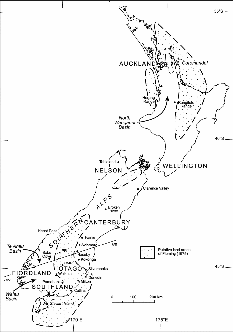
New Zealand's biota is regarded as having evolved largely from plants and animals sequestered on a drifting fragment of the Gondwanaland supercontinent. In isolation for more than 80 million years, a distinctive New Zealand biota is envisaged as evolving, to a greater or lesser extent, from archaic Gondwanan stock (Fleming, Reference Fleming1962, Reference Fleming1979; Mildenhall, Reference Mildenhall1980; Stevens, Reference Stevens1985; Cooper & Millener, Reference Cooper and Millener1993). This hypothesis has been popularly referred to as ‘Moa's Ark’ (Bellamy, Spingett & Hayden, Reference Bellamy, Spingett and Hayden1990). In contrast, an important corollary to the wave-planation hypothesis is that the amount of landmass shrank dramatically from Late Cretaceous to Early Miocene time (85 to 22 million years) at which time most, if not all, of the New Zealand region was inundated (LeMasurier & Landis, Reference Lemasurier and Landis1996). During this time, we suggest that the original Moa's Ark (Zealandia) probably sank beneath the sea and lost its precious cargo. Although previous workers, treating the surface as a peneplain, recognized that Palaeogene transgression reduced the area of land in the New Zealand region (e.g. Wellman, Reference Wellman1953; Fleming, Reference Fleming1962; Suggate, Stevens & Te Punga, Reference Suggate, Stevens and Te Punga1978; Stevens, Reference Stevens1985; Cooper & Cooper, Reference Cooper and Cooper1995; King et al. Reference King, Naish, Browne, Field and Edbrooke1999), they nevertheless portray the region as one of substantial land even at the time of maximum transgression (Fig. 1). The main arguments supporting the existence of sizeable remaining land areas during Oligocene–Early Miocene time are not clear and have never been properly discussed. They appear to depend substantially, but tacitly, on three factors: (1) the nature and diversity of the modern New Zealand flora and fauna, (2) the fossil record and (3) the absence today of middle Cenozoic marine sedimentary rocks from inland portions of North and South islands as well as from central Fiordland and Stewart Island. Interpretations drawn from these starting points may not be soundly based and, most worryingly, probably suffer from circular reasoning (Waters & Craw, Reference Waters and Craw2006).
Map showing localities referred to in text and extent of land during maximum transgression as proposed by Fleming (Reference Fleming1962). We propose that all the land areas shown by Fleming, as well as other authors such as Stevens (Reference Stevens1974, Reference Stevens1985), Kamp (Reference Kamp1986) and King (Reference King, Cooper and Jones1998, Reference King2000), may have been completely submerged during the Oligocene. HR – Hawkdun Range, PR – Pisa Range, ML – Mt Luxmore, OMR – Old Man Range. The NE–SW line refers to the cross-section shown in Figure 5.

We maintain that the modern landscape combined with the Cenozoic sedimentary record provide evidence which is incompatible with the existence of substantial land areas of Late Oligocene–earliest Miocene age. Furthermore, we argue that available data are compatible with complete inundation of the New Zealand region during middle Cenozoic time. This, in turn, implies that most, if not all, of the present-day terrestrial fauna and flora of New Zealand may be of geologically recent origin, having evolved from colonization by water-borne and air-borne waifs, strays and pioneers that arrived during the past 22 million years. This view will represent a paradigm shift for many biologists who have previously laboured under an appealing hypothesis founded on limited evidence. Here we review and consider the geological evidence underlying this prevailing hypothesis of an enduring landmass.
In this paper we discuss the Waipounamu Erosion Surface concept, the merit of the term ‘peneplain’, and whether one exists in the New Zealand region. We then discuss the evidence for location of palaeo-shorelines, and the significance of unconformities of Oligocene age. After discussing inland occurrences of Oligocene marine rocks, we discuss the clastic component of Oligocene sediments and the distribution of shallow marine, estuarine and terrestrial deposits of Oligocene age, as recorded in the fossil record (that is, the Fossil Record File, a national database of all known fossil localities within New Zealand). Following discussion of specific areas that have previously been interpreted as possible Oligocene terrestrial deposits, we discuss examples of long-range dispersal of terrestrial biota.
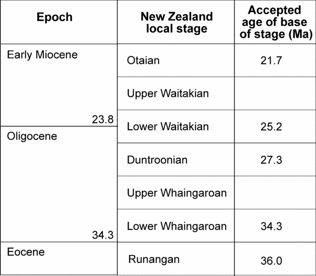
The period during which marine transgression reached its peak in the New Zealand region ranges from the Early Oligocene to Early Miocene. The period is well represented onshore by marine deposits which have been subdivided into three local biostratigraphic stages, the Whaingaroan, Duntroonian and Waitakian (Cooper, Reference Cooper2004). The Whaingaroan and Waitakian are readily divisible into lower and upper subunits. The currently accepted ages for the boundaries between the stages are shown in Figure 2.
The local New Zealand biostratigraphic subdivision for latest Eocene, Oligocene and earliest Miocene time is based on marine faunas found widely across onshore New Zealand. Local stages are based on first occurrences of particular species, and thus the top of a stage is defined by the base of the following stage. Age values are those of Cooper (Reference Cooper2004).

Thus, age control of marine deposits for the period of marine transgressive significance is reasonable. In contrast, onshore non-marine deposits are rare for this time interval, and palynological age control is poor (see Section 3.h). Constraint on the age of the few deposits of non-marine origin is generally achieved using the ages of marine units underlying and/or overlying them.
The timing of maximum marine transgression probably varies across the country according to proximity to structures generated or exploited by the resurgence of tectonic activity along the plate margin. As a general rule, we adopt herein a Waitakian Stage timing (latest Oligocene to earliest Miocene; c. 25–22 Ma) for maximum marine transgression, this being substantiated by a search of 4602 localities recorded in the New Zealand fossil record system (see Section 3.h).
2. Waipounamu Erosion Surface and/or Cretaceous Peneplain?
Historically, New Zealand's regional erosion surfaces have been considered as ‘peneplains’, senescent landscapes formed during prolonged tectonic quiescence by subaerial erosion. In contrast, the Waipounamu Erosion Surface can be shown to have formed as a result of coastal and shallow marine erosion. In this section we discuss evidence for existence of the New Zealand peneplain, suggesting that this geomorphic feature is mostly attributable to the Waipounamu Erosion Surface.
It is important to distinguish between the Waipounamu Erosion Surface and the ‘Cretaceous Peneplain’. The ‘Cretaceous Peneplain’ (also referred to as Otago Peneplain) refers to a widespread unconformity of terrestrial origin. It is characterized by an unconformity with weakly indurated Late Cretaceous sand, gravel and coal measures resting upon indurated and deformed Palaeozoic–Mesozoic igneous, sedimentary and metamorphic basement. A non-marine origin is inferred from fluvial and paludal features of the overlying sedimentary cover. In contrast, the Waipounamu Erosion Surface is of marine origin. It too is extensively developed directly onto the Palaeozoic–Mesozoic basement, while elsewhere it constitutes a disconformity developed upon the scoured top of the non-marine strata covering the ‘Cretaceous Peneplain’. In areas where the Waipounamu Erosion Surface is developed directly on older basement, the ‘Cretaceous Peneplain’ is absent. Formation by marine and littoral processes is inferred from marine fossils, glauconite and sedimentary features in the basal sedimentary cover. Thus the two unconformities are sub-parallel surfaces. In many localities, the Waipounamu Erosion Surface truncates the ‘Cretaceous Peneplain’. Where both surfaces are present locally, the Waipounamu Erosion Surface is always the younger. Where preserved, the non-marine sequences separating the two erosion surfaces range from a few metres to more than 500 m thick (LeMasurier & Landis, Reference Lemasurier and Landis1996; Harrington, Reference Harrington1958).
Despite their superficial similarity, both lying at or near the base of the Kaikoura Sequence (Carter, Reference Carter1988), conceptually these two surfaces are profoundly different. The ‘Cretaceous Peneplain’ is envisaged as the end-product of long-continued subaerial weathering and fluvial erosion of the New Zealand region, initially as a portion of Gondwanaland and continuing after separation of Zealandia from Gondwanaland about 85 Ma (Sutherland, Reference Sutherland1999). The Waipounamu Erosion Surface entirely post-dates separation of Zealandia and represents marine planation of the gradually submerging, tectonically stable, Zealandia continent.
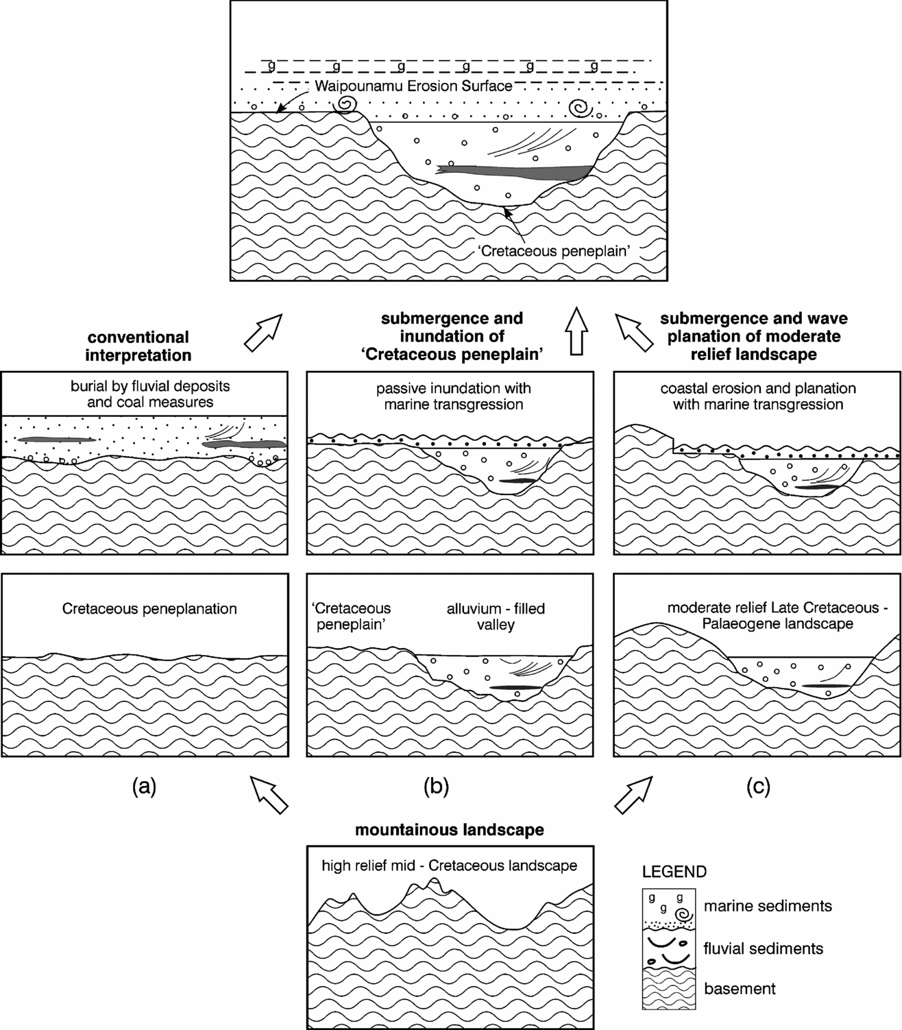
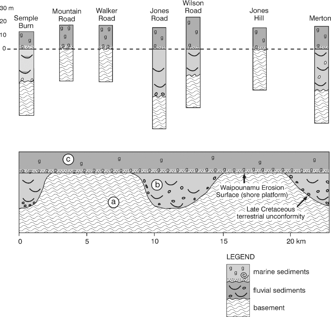
In theory, the ‘Cretaceous Peneplain’ formed when prolonged subaerial erosion had proceeded to the point where relief of the land surface had become negligible. The point at which such a surface becomes sufficiently flat to be termed a peneplain remains a semantic issue since the maximum relief permitted on a peneplain has never been rigorously defined (Flemal, Reference Flemal1971; Summerfield, Reference Summerfield1991). The original description of the term peneplain (Davis, Reference Davis1889a, Reference Davis1899), as well as modern usage (Skinner & Porter, Reference Skinner and Porter1987; Press & Siever, Reference Press and Siever1974), accept that peneplains are low-relief terrestrially eroded surfaces of regional extent, graded to sea-level, which owe their minimal relief to prolonged subaerial weathering, mass-wasting and fluvial erosion. The relationships between the ‘Cretaceous Peneplain’ and the Waipounamu Erosion Surface are shown in Figure 3.
Spatial relationships between the ‘Cretaceous Peneplain’ and the Waipounamu Erosion Surface. Assuming an original high-relief mountainous landscape in Zealandia dating from middle Cretaceous break-up (at bottom), three scenarios are presented: (a) the conventional interpretation, showing peneplanation by terrestrial processes followed by deposition of a mantle of fluvial and coal-measure sediments. During subsequent subsidence, transgressive marine strata accumulated around the coastal periphery of Zealandia; (b) Cretaceous peneplanation of Zealandia is accompanied by deposition of non-marine sediment in erosional valleys draining the interior; marine transgression gradually inundates the subdued and deeply weathered continental margin; and (c) (the option preferred here) channel-fill fluvial and swamp sediments are deposited in erosional valleys within the moderate-relief Zealandia continent. Coastal erosion accompanying thermal subsidence forms extensive surfaces of marine planation upon which re-worked clastics plus fresh first-cycle basement-derived sediment is deposited. Subsidence and coastal erosion continued for at least 40 million years, the resulting transgression eventually covering Zealandia. Thus, along the present-day coast, shallow marine coarse clastic sediments of Late Cretaceous age fine upward to marl, greensand and eventually Oligocene limestone. (On diagram: g – greensand).

A further problem remains: does the so-called ‘Cretaceous Peneplain’ unconformity really represent a peneplain? Davis' (Reference Davis1889a, Reference Davis1899) original use of the term is inextricably linked to his concept of a ‘geographical cycle’ in which peneplain constitutes the (extreme or penultimate) end-product of the erosion cycle beginning with abrupt formation of mountains and followed by their gradual wearing away through stages known as youth, maturity and old age. The peneplain represented the theoretical culmination of the erosion cycle, a ‘base-level/lowland’ (Davis, Reference Davis1889b, Reference Davis1899) landscape senility. Since Davis' concept of cyclic landscape evolution is no longer regarded as valid (e.g. Flemal, Reference Flemal1971; Thornbury, Reference Thornbury1969; Summerfield, Reference Summerfield1991; Skinner & Porter, Reference Skinner and Porter1987; Morisawa, Reference Morisawa1989), it may be necessary to reject the very existence of peneplains as well. Many workers (e.g. Thornbury, Reference Thornbury1969; Flemal, Reference Flemal1971) have emphasized that no modern-day peneplain has been described. All peneplains (including New Zealand's ‘Cretaceous Peneplain’) are fossil surfaces.
The classical erosion surfaces on which the peneplain concept is based (Davis, Reference Davis1889a) are dissected ancient surfaces. For example, the well-known Appalachian surfaces (e.g. Harrisburg and Schooley peneplains) were regarded as late Mesozoic and early Cenozoic in age. Their recognition was based on concordant ridge crest elevations but their origin as remnants of old age landscapes of regional extent is no longer accepted by geomorphologists. Hack (Reference Hack1960) described the Davisian peneplain as ‘an imaginary landscape which is never actually attained’. Hack (Reference Hack1960) maintains that the Davisian surfaces are founded on existing features but that their origins have been misinterpreted.
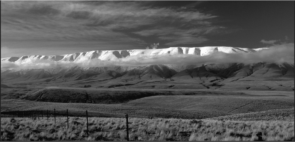
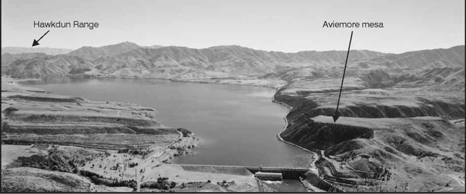
Despite the absence of documented examples of peneplains formed on Earth today, it remains possible that one might have formed during the Cretaceous in New Zealand. We will now consider evidence bearing on the ‘Cretaceous Peneplain’ hypothesis. Visually, the most impressive feature cited as evidence lies in the remarkably flat nature of upland surfaces in southern South Island (Fig. 4). In Central Otago, undissected summit plateaux at 1000–1500 m characterize many Neogene mountain ranges. These surfaces clearly pre-date Late Miocene–Recent folding and faulting that created the ranges. The upland surfaces are underlain by highly deformed Palaeozoic–Mesozoic greywacke and schist basement, with local lenses of quartzose gravel and sand resting unconformably on the ‘peneplained’ basement. Ages of these lenses of cover strata are unknown, but correlation with similar sequences exposed in adjacent basins and on lower ranges indicates that they are Cenozoic fluvial deposits occupying channels cut into the deformed basement prior to Neogene folding and faulting (Youngson, Reference Youngson2005).
Hawkdun Range viewed from the south showing the distinctive planar summit at 1500 m (location in Fig. 1). This high-level plateau is a remnant of the Waipounamu Erosion Surface, eroded into Palaeozoic–Mesozoic greywacke during Cretaceous–Oligocene marine transgression. The range has been uplifted during the last five million years. Inferred Palaeogene marine cover has been removed by Neogene fluvial and periglacial erosion processes. However, a well-developed marine transgressive Palaeogene sequence culminating in limestone and greensand rests on greywacke basement where it is preserved in a fault angle depression at Aviemore to the northeast (see Fig. 7). Photo: Arno Gasteiger.

Similar quartzose sediments of well-constrained Late Cretaceous age rest unconformably on metamorphic basement in coastal Otago (Harrington, Reference Harrington1958; LeMasurier & Landis, Reference Landis and Youngson1996; Landis & Youngson, Reference Landis and Youngson1996). These strata are of fluvial origin, predominantly coarse sand and gravel, and commonly contain coal seams. They underlie the transgressive marine sequence, forming discontinuous lenses resting on the ‘Cretaceous Peneplain’.
Several aspects of these cover strata pose problems for the peneplain hypothesis. First, there is no evidence in Central Otago for Cretaceous (or Paleocene) terrestrial planation or sedimentation. Second, Cretaceous non-marine sediments in coastal Otago are coarse-grained deposits of gravel-bed rivers. They contain little of the fine-grained mud that would be expected in the old age, very low-gradient rivers meandering across a deeply weathered landscape of regional extent. However, such a scenario is essential to the peneplain hypothesis. Third, there are no data demonstrating the presence of a nearly planar fluvial surface underlying the Cretaceous–Cenozoic non-marine cover sequence. Fourth, the presence of intensely altered basement underlying the cover strata, although compatible with deep weathering of a peneplain surface, has never been demonstrated to have formed by surface processes prior to deposition of the cover strata. For example, in Central Otago, Craw (Reference Craw1994) has shown that intense alteration of schist basement conventionally ascribed to deep weathering of the peneplain surface actually occurred after deposition of non-marine Miocene cover-strata. At Mountain Road in the Silver Peaks of East Otago (Figs 5, 6), where schist basement is also intensely altered, Landis & Youngson (Reference Landis and Youngson1996) have reported the presence of intensely altered schist boulders and cobbles within basal cover-strata resting unconformably on basement. Alteration of these schist clasts is identical to alteration of underlying bedrock schist. They are surrounded by well-sorted marine sands, and their soft and friable condition indicates that they could not have been transported any distance by erosion processes. In some places it is possible to confuse schist boulders with schist basement. Since their alteration is clearly post-depositional, it follows that identical alteration of the identical underlying schist also post-dates formation of the erosion surface.
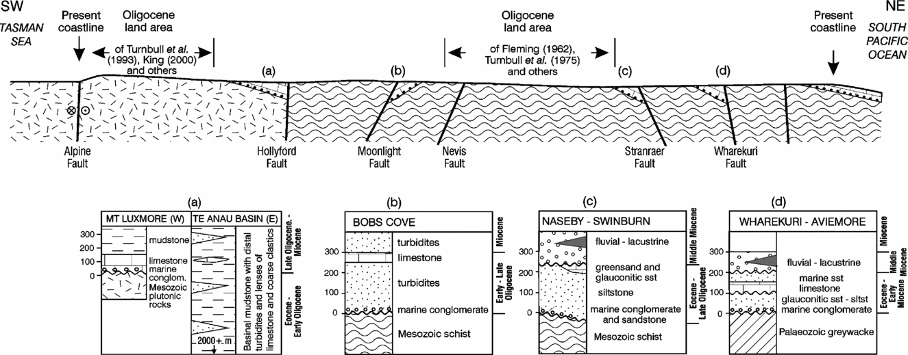
Cross-section of South Island showing Cenozoic sequences at key localities. The Oligocene land as interpreted by earlier workers is based on absence of Oligocene sediment in these areas. We suggest that the entire region was submerged during the Late Oligocene on the basis of planated schist mountain topography and transgressive sequences exposed around the periphery of the proposed landmass. The line of section is shown in Figure 1.

Stratigraphic relations between basement and cover strata as exposed along the eastern side of the Silver Peaks region, East Otago. An undulating Late Cretaceous terrestrial unconformity (‘peneplain’) developed on Mesozoic schist (a) is overlain by discontinuous lenses of fluvial sands and gravels (b). Both of these units are in turn cut by a latest Cretaceous–Palaeogene shallow marine erosion surface (Waipounamu Erosion Surface) which has planed off residual topographic relief on schist basement. Overlying transgressive marine sediments (c) comprise sands and silts containing first-cycle schist clasts and re-worked fluvial sediment (basal) overlain by silts containing glauconite (g) and occasional molluscan fossils. Photographs of this area are presented by LeMasurier & Landis (Reference Lemasurier and Landis1996, p. 1457, fig. 5).

In our experience, unlike the Waipounamu Erosion Surface, the ‘Cretaceous peneplain’ does not define a planar geomorphic feature. Surfaces we refer to as ‘Cretaceous peneplain’ are unconformable contacts separating basement from non-marine Cretaceous–Palaeogene cover strata. They are sediment-filled palaeo-valleys. Most of the ‘iconic’ erosion surfaces of inland Otago and Canterbury lack Cretaceous–Palaeogene sedimentary cover. Where these are prominent and planar landscape features, we interpret them as remnants of the Waipounamu Erosion Surface rather than the ‘Cretaceous peneplain’, in view of the preceding discussion.
If we accept that the relict planar erosion surface in Canterbury and Otago (or even a large portion of it) represents the Waipounamu Erosion Surface and is of marine origin, then the landmass proposed by Fleming (Reference Fleming1962), Stevens (Reference Stevens1985) and others is at least one-third smaller than proposed, and in our view may have been absent entirely.
3. Cenozoic palaeo-shorelines
Published palaeogeographic maps show Oligocene–Early Miocene New Zealand as a low relief archipelago (Fig. 1). The area of land at the time of maximum transgression is generally shown as being less than today but still substantial.
Although detailed evidence for placement of shorelines has not been discussed by previous workers (e.g. Fleming, Reference Fleming1979; Hornibrook, Reference Hornibrook, Tuschi and Ingle1992; King et al. Reference King, Naish, Browne, Field and Edbrooke1999), different combinations of eight factors appear to have influenced palaeogeographic map reconstructions:
(a) The interpretation of Oligocene submarine unconformities as surfaces of subaerial erosion.
(b) The interpretation of the most inland outcrops of Oligocene–Early Miocene marine sedimentary rock as near proxies for palaeo-shoreline positions.
(c) Interpretation of planated pre-Cenozoic basement rock as an exhumed Cretaceous peneplain surface of subaerial origin.
(d) Interpretation of siliciclastic detritus in Oligocene and Early Miocene sedimentary rocks as first-cycle sediment derived from adjacent landmasses.
(e) The assumption that thin and locally developed middle Cenozoic shallow marine and littoral deposits represent substantial periods of time.
(f) Interpretation of evidence which is permissive of emergence as evidence supporting the existence of emergent areas.
(g) Commitment to the view that New Zealand's modern terrestrial biota has evolved in isolation, following Cretaceous break-up of Gondwanaland and continuing to the present day.
(h) Assumptions about the fossil record and its completeness.
These points are discussed below.
3.a. Unconformities of Oligocene age
Unconformities of Oligocene age are widespread in sedimentary rocks throughout New Zealand (e.g. Carter, Reference Carter1988; Field & Browne, Reference Field and Browne1989; Turnbull & Uruski, Reference Turnbull and Uruski1990; Turnbull et al. Reference Turnbull, Uruski, Anderson, Lindqvist, Scott, Morgans, Hoskins, Raine, Mildenhall, Pocknall, Beu, Maxwell, Smale, Watters and Field1993; King et al. Reference King, Naish, Browne, Field and Edbrooke1999). One distinctive break, the Marshall Paraconformity, is recognized in sections throughout New Zealand and underlying the surrounding sea-floor (Carter & Landis, Reference Carter and Landis1972; Fulthorpe et al. Reference Fulthorpe, Carter, Miller and Wilson1996). Now recognized as having formed during Oligocene erosion of the sea-floor in association with initiation of the circumpolar current and sediment starvation during maximum transgression (e.g. Carter, Reference Carter1985), this unconformity was ascribed by early workers to emergence and subaerial erosion. For example, the pioneering palaeogeographic maps of Fleming (Reference Fleming1962, Reference Fleming1979) showed the East Otago area as land during the Oligocene (see Silverpeaks to Catlins on Fig. 1). At most localities, the Marshall Paraconformity and related Oligocene paraconformities mark abrupt breaks separating fully marine sequences above and below. Although mainly intra-Oligocene with duration of 2 to 4 Ma, in some areas (e.g. Dunedin and the Canterbury Shelf) the Marshall Paraconformity separates slope–bathyal Late Eocene mudstone from Miocene outer shelf or deeper greensand and represents a gap exceeding 10 million years (Fulthorpe et al. Reference Fulthorpe, Carter, Miller and Wilson1996). In most of North Otago and South Canterbury, Oligocene and earliest Miocene sequences are extremely condensed, the paraconformity itself representing missing Oligocene time of 2 to 3 million years (e.g. Carter, Reference Carter1985; Loutit et al. Reference Loutit, Hardenbol, Vail, Baum, Wilson, Hastings, Kendall, Posamentier, Ross and Van Wagoner1988). Although the possibility of occasional local terrestrial conditions cannot be totally eliminated (e.g. Lewis & Bellis, Reference Lewis and Bellis1984), the presence of offshore marine strata directly above and below an unconformity cannot be construed as supporting the hypothesis of continuous emergence during the intervening period. Recognition of the Marshall Paraconformity within marine sequences beneath the deep sea-floor around New Zealand (Carter & Landis, Reference Carter and Landis1972; Carter, Reference Carter2003) provides additional support for a submarine origin of this same unconformity exposed so widely in on-land New Zealand.
3.b. Inland occurrences
The most-inland occurrences of marine strata in East Otago and South Canterbury coincide approximately with the position of the Oligocene shoreline as portrayed on maps by Wellman (Reference Wellman1953), Fleming (Reference Fleming1962, Reference Fleming1979), Stevens (Reference Stevens1974), Kamp (Reference Kamp1986) and many others. These workers have drawn the shorelines at, or only a short distance inland from, outcropping marine strata. However, evidence inferred from sedimentary facies sequences (e.g. Walther's Law: Middleton, Reference Middleton1973) at these inland-most localities requires that Oligocene–Early Miocene transgression must have advanced further inland, beyond those outcrops. For example, consider the area around Lake Aviemore (Waitaki Valley, South Island; Fig. 7), just inland of which the Oligocene shoreline is shown on numerous palaeogeographic maps. This region, 45–50 km inland from the present coast, is well known for its rich Cenozoic marine molluscan faunas (Marwick, Reference Marwick1935; see also stratigraphic summary in Field & Browne, Reference Field and Browne1989). Correlative marine strata occur from Aviemore to the east coast at Oamaru and beneath the adjoining continental shelf. The Cenozoic sequence exposed north of Aviemore Dam commences with fossiliferous and pebbly glauconitic sands of Eocene age resting unconformably upon planated Permian–Triassic greywacke basement (the Waipounamu Erosion Surface). These basal Cenozoic strata, ravinement deposits, are overlain by a sequence of increasingly offshore transgressive marine units, culminating in 60 m of Oligocene greensand of outer shelf depth and 20 m of richly fossiliferous outer shelf limestone of Late Oligocene to earliest Miocene age (Marwick, Reference Marwick1935; Gage, Reference Gage1957; T. S. Loutit, unpub. report, 1973; Field & Browne, Reference Field and Browne1989; I. McDermid, unpub. report, 1998). Age and thickness of this transgressive sequence imply that submarine accommodation space was available from Middle Eocene through all of Oligocene time, a period of at least 15 million years. Contemporaneous Oligocene terrestrial or clastic shoreline facies are not recognized in this area, and if any actually existed they must have lain far to the west. Comparing the sediment facies characteristic of maximum transgression at Aviemore and inland Canterbury (greensand, marl, foraminiferal limestone) with facies on present-day passive continental margins elsewhere in the world, a depositional setting of at least tens and probably hundreds of kilometres from shore is suggested. It can be concluded that there is no sedimentological evidence for the presence of Late Oligocene–earliest Miocene terrestrial environments being situated anywhere near the Aviemore locality. Similar relations are recognized widely in the foothills of the Southern Alps (e.g. Gage, Reference Gage1970), along the margin of Fiordland (Turnbull et al. Reference Turnbull, Uruski, Anderson, Lindqvist, Scott, Morgans, Hoskins, Raine, Mildenhall, Pocknall, Beu, Maxwell, Smale, Watters and Field1993), in the NW South Island (Grindley, Reference Grindley1961) and elsewhere. These will be discussed later.
Aviemore, a mesa-like remnant of the stripped Waipounamu Erosion Surface; to immediate right of the Lake Aviemore Dam (see Fig. 1 for location). Aviemore is the most inland remnant of preserved Cenozoic marine sequence. Gravelly Eocene marine sediments rest directly on greywacke basement. These are overlain by a transgressive marine sequence including Oligocene limestone and greensand. The crest of the Hawkdun Range (Fig. 4; see HR on Fig. 1) is visible in the far distance about 40 kilometres away. Pleistocene alluvial terraces are conspicuous along the southern (left) side of the valley. View looking NW up the Waitaki River valley. Photo: Lloyd Homer, GNS Science.

3.c. Aviemore and Silverpeaks
Also at Aviemore (see Section 3.b above), a distinctive planar erosion surface is well exposed on a table-like hill (mesa) that is underlain by Permian greywacke, one kilometre north of the Aviemore Dam (Fig. 7). We infer that this conspicuous surface is not a peneplain (the traditional interpretation); rather, it is the Waipounamu Erosion Surface that has been cut by Eocene wave planation. The conspicuously flat top of the mesa is an exhumed angular unconformity from which transgressive Palaeogene marine sediments have been largely stripped by late Neogene erosion. However, remnant lenses of cover sediment rest directly on the unconformity and they consist of fossiliferous and glauconitic pebbly marine sands of Paleocene–Eocene age. Similarly planar, but commonly much higher, ridges are well exposed elsewhere in the Waitaki Valley and to the south and west in Central Otago. For example, the Rock and Pillar, Dunstan, Hawkdun, Old Man and Pisa ranges (Figs 1, 4) are all late Cenozoic fold and fault-bounded ranges that are characterized by planar summits. Although stripped of a postulated earlier Cenozoic marine sediment cover, the morphological similarity of these high ranges to the Aviemore mesa is striking, and correlation of these surfaces is confidently proposed.
Planar ridge crests are also conspicuous in East Otago. For example, in the Mountain Road area of the Silver Peaks (Figs 5, 6), a conspicuously flat surface is cut into biotite schist. Previously regarded as forming part of the exhumed Cretaceous peneplain (Benson, Reference Benson1935; Mortimer, Reference Mortimer1993; Bishop, Reference Bishop1994), much of the ridge is thinly veneered by 1–3 m of latest Cretaceous–Paleocene marine sediment (LeMasurier & Landis, Reference Lemasurier and Landis1996; Landis & Youngson, Reference Landis and Youngson1996) and is now interpreted as having been planated by wave processes, not by fluvial erosion. This surface is identified as an early-formed portion of the Waipounamu Erosion Surface.
Wave planation is the only surficial erosional process capable of forming regional surfaces on bedrock as flat as those that characterize the planar landscapes in the Aviemore region, the Silver Peaks tableland (LeMasurier & Landis, Reference Lemasurier and Landis1996, Fig. 6), and similar planated basement in East Otago. Despite being degraded by Pleistocene periglacial processes (Wood, Reference Wood1969; Stirling, Reference Stirling1990), the characteristic flat crests of the Central Otago mountain ranges (1000–1500 m) are strikingly similar to their lower-elevation correlatives at Aviemore, Silver Peaks and elsewhere. They are all regarded as uplifted portions of the Waipounamu Erosion Surface. The absence of marine sediment from these more highly uplifted exhumed planar erosion surfaces is attributed to late Cenozoic uplift and associated terrestrial erosion. Not only that, but the absence of erosion surfaces further to the west can itself be attributed to ongoing Neogene uplift and erosion. Reduced erosion at lower elevations has permitted the outlying marine remnants to be preserved.
3.d. Siliciclastic sands
The presence of siliciclastic sands in Late Oligocene–Early Miocene sediments may also be used to argue for proximity of contemporaneously eroding land areas consisting of basement rock (King et al. Reference King, Naish, Browne, Field and Edbrooke1999). For example, terrigenous sands within the Late Oligocene–Early Miocene Milburn Limestone of East Otago might be taken to imply derivation from outcrops of schist basement proximal to the area of outcrop. Thus, maps of Fleming (Reference Fleming1962), Kamp (Reference Kamp1986) and others place the Oligocene shoreline on Haast Schist basement only a few kilometres inland from Milburn (Fig. 1). Petrographic study of the non-carbonate fraction of the Milburn Limestone is instructive in this respect. Samples collected from a 22 m section exposed in the old Milburn Lime Quarry were dissolved in dilute hydrochloric acid and analysed in 12 grain-mount thin-sections (CAL and S. Wilson). Insoluble residues ranged from 2–3% near the base to 20–40% high in the section. Quartz is the dominant mineral with glaucony pellets also common, especially in fine sand fractions where they may form up to 50%. Both quartz and glaucony tend to be well rounded and polished. The glaucony is interpreted to be a transported intrabasinal constituent and is excluded from the terrigenous siliciclastic fraction.
On a calcite- and glaucony-free basis, feldspar is the only other abundant constituent, accounting for 13–21%. Heavy minerals (hornblende, garnet, opaques) combined with altered rock fragments range from trace amounts to 5%. Potassic feldspars (orthoclase and microcline) comprise 13–19% with Na–Ca plagioclase up to 3.5%. Significantly, potassic feldspar and hornblende are absent from the Haast Schist basement throughout Otago, where end-member albite is the sole feldspar mineral. The terrigenous sand component of the Milburn Limestone is thus arkosic in composition and granitic provenance is implied. The nearest compatible crystalline basement exposed today is in Fiordland and Stewart Island (Fig. 1). However, the high degree of rounding strongly suggests a re-worked sediment source. Eocene shelf sediments in East Otago (e.g. Green Island Sandstone) and correlative units in the offshore Great South Basin (Beggs, Reference Beggs1978) are rich in potassic feldspar and may suggest contemporaneous erosion of a distant siliciclastic source area. Regardless, there is no evidence that adjacent schist basement contributed detritus to the Milburn Limestone. Potassic feldspar and hornblende are found widely in basal marine Cenozoic sediments around the margins of the schist. We conclude that schist basement in East and Central Otago was already fully inundated by the transgressive Oligocene sea.
3.e. Local occurrences of shallow marine and estuarine sediments
Local occurrences of shallow marine and estuarine sediments have also been taken to provide evidence for the location of palaeo-shorelines in previous palaeogeographic maps. In itself, this may be a sound interpretation. However, it is not valid to assume that exposed sediments actually represent sustained or precisely dated periods of sediment accumulation or that these sediments did not extend further inland.
A good example is found in the region of Pomahaka in West Otago (Fig. 1) where estuarine beds, comprising mainly shelly mudstone, rest unconformably on late Palaeozoic–Mesozoic basement (Wood, Reference Wood1956; Isaac & Lindqvist, Reference Isaac and Lindqvist1990). A general Oligocene age is widely accepted. It is likely that they represent a depositional interval occurring at the beginning of a prolonged regional transgressive marine episode. Locally, Oligocene marine strata (Chatton Marine Beds; Wood, Reference Wood1956) are present above the Pomahaka Beds but these late Palaeogene strata are rarely exposed, the area being dominated by low-relief deeply eroded Mesozoic basement mantled by Neogene fluvial gravel. Fluvial gravel rests unconformably upon localized erosion remnants of the earlier marine and estuarine strata. Thus the absence of more widespread middle Cenozoic marine deposits overlying these basal transgressive strata cannot be taken as evidence that marine conditions never extended into the more uplifted and deeply eroded areas adjoining Pomahaka.
To the contrary, the nature and thickness of (about 90 m) of the Pomahaka and Chatton formations imply gradual regional subsidence with middle Cenozoic estuarine and marine strata originally extending inland from Pomahaka. No mechanism that would permit the Oligocene–Miocene shoreline to have remained in the Pomahaka area during deposition of the documented estuarine marine sequences (90 m thick) can be envisaged. For example, any basin formed by flexure of the Otago continental crust at this locality must have been on a scale requiring subsidence (and complimentary marginal uplift) to have extended further inland by at least tens of kilometres. Thus sediments at Pomahaka, while recording transgression along the margin of an Oligocene marine basin, also imply that the basin margin must have migrated further inland to permit accommodation of the exposed sequence. Late Oligocene and Early Miocene limestone and greensand, while not exposed at Pomahaka or directly to the north, do occur at all but one of the named South Island locations surrounding Pomahaka as shown on Figure 1. It can be confidently inferred that marine conditions covered the entire area.
3.f. Evidence that is permissive but not compelling
Evidence that is permissive but not compelling also appears to have played a major but tacit role in postulating substantial Oligocene–Early Miocene land areas in New Zealand. Examples can be cited from the Southern Alps, Fiordland, Catlins and central and western North Island.
For example, a middle Cenozoic land area in the region of the present Southern Alps is shown on all published palaeogeographic maps. While extent and location of this land varies from map to map it is invariably shown to be present but not accompanied by evidence or explanation. For instance, the area around Haast Pass (Fig. 1) is shown as lying above sea-level continuously from the Cretaceous to the present day (e.g. Fleming, Reference Fleming1962; Stevens, Reference Stevens1985; Kamp, Reference Kamp1986; King et al. Reference King, Naish, Browne, Field and Edbrooke1999). Since no pre-Pleistocene sediments are present in this area, the inferred landmass can neither be proved nor disproved. However, this area of postulated Oligocene land is also a region of maximum Neogene uplift and deep erosion along the modern plate boundary (Koons, Reference Koons1990). Metamorphic basement is exposed throughout the region and any Cenozoic cover has been eroded away. Marine sequences are documented from areas of lesser uplift (and lesser Neogene erosion) on all sides of the Haast Pass area. Typically these are transgressive sequences showing increasingly offshore character from Early Cenozoic to Oligocene–Early Miocene, culminating with limestone sequences. We can therefore confidently assume that transgression proceeded well beyond all of these limiting outcrops. It probably covered the Haast Pass region as well. Thus, whereas there is no geological evidence to suggest a persistent early–middle Cenozoic landmass anywhere in the Haast Pass area, all available geological data are compatible with middle Cenozoic submergence.
3.g. The Moa's Ark heritage
The history of New Zealand's biota has been presented from the viewpoint of evolution of plants and animals stranded on an isolated emergent ‘raft’ for millions of years. This raft, a fragment of the Gondwanaland supercontinent, has been surrounded by oceans since Late Cretaceous time. It is seen as an isolated natural laboratory carrying a precious cargo of Mesozoic plants and animals. In this view, evolution in response to changing environmental pressures operating on the descendants of the original (Mesozoic) plants and animals has resulted in creation of the modern New Zealand biota.
This concept, popularized recently as ‘Moa's Ark’ (Bellamy, Spingett & Hayden, Reference Bellamy, Spingett and Hayden1990) has great public appeal and has become deeply rooted in New Zealand's national identity. It has been backed by many proponents for more than forty years (e.g. Fleming, Reference Fleming1962; Wardle, Reference Wardle1963) and is found widely in modern popular science literature (e.g. Wilson, Reference Wilson2004; Stevens, McGlone & McCulloch, Reference Stevens, McGlone and McCulloch1988; Flannery, Reference Flannery1994). Although a small degree of long-distance dispersal following Gondwanaland break-up is widely accepted (Fleming, Reference Fleming1979; Mildenhall, Reference Mildenhall1980; Wardle, Reference Wardle1984; Stevens, McGlone & McCulloch, Reference Stevens, McGlone and McCulloch1988), the distinctiveness and lack of mobility of the modern terrestrial biota has resulted in a prevailing understanding that assumes that substantial terrestrial habitats must have existed continuously since Cretaceous break-up, and that the unique biota of New Zealand is a product of ancient isolation.
However, accumulating biological evidence contradicts this view of the biogeographic history in New Zealand. Pole (Reference Pole1993) argued, using fossil data, that a significant proportion of New Zealand plants have evolved from Cenozoic colonists. In a later paper, he suggested (Pole, Reference Pole1994; see also Pole, Reference Pole2001) that the entire flora may have developed since the Oligocene. Most molecular studies have suggested that groups found in New Zealand, rather than being remnants from Gondwanan times, are actually much more recent in origin and have colonized across the significant water gaps around New Zealand. Examples include southern beeches (Swenson et al. Reference Swenson, Backlund, McLoughlin and Hill2001; Knapp et al. Reference Knapp, Stöckler, Havell, Delsuc, Sebastiani and Lockhart2005), spiders (Griffiths, Paterson & Vink, Reference Griffiths, Paterson and Vink2005), moths (Brown, Emberson & Paterson, Reference Brown, Emberson and Paterson1999), kiwis (Cooper et al. Reference Cooper, Mourer-Chauvire, Chambers, Haeseler, Wilson and Paabo1992) and various flightless insects (Trewick, Reference Trewick2000). Only a few species have levels of molecular variation that are compatible with a Gondwanan origin, such as tuatara (Rest et al. Reference Rest, Ast, Austin, Waddell, Tibbets, Hay and Mindell2003), leiopelmatid frogs (Roelants & Bossuyt, Reference Roelants and Bossuyt2005), kauri (Stöckler, Daniel & Lockhart, Reference Stöckler, Daniel and Lockhart2002) and terrestrial gastropods (McDowall, Reference McDowall2004). However, ancient lineages, on their own, say very little about the palaeobiogeographic distribution of their ancestors; there is no easy way to tell if such a lineage has not colonized relatively recently before going extinct at the source. Evidence is also accumulating that overseas dispersal is generally an important factor among Southern Hemisphere biota (Sanmartin & Ronquist, Reference Sanmartin and Ronquist2004) and that asymmetrical colonization rates between areas will often mimic geological rifting scenarios (Cook & Crisp, Reference Cook and Crisp2005). In this case, westerly wind-flows and currents that make the colonization of New Zealand from Australia more likely than movement in the other direction provide a similar pattern to that expected from a ‘Gondwana ark’. This has led McGlone (Reference McGlone2005) to comment that rather than ‘the land that time forgot’, New Zealand is the ‘flypaper of the Pacific’. Recently, Campbell & Landis (Reference Campbell and Landis2001) have suggested that the entire New Zealand terrestrial biota actually became established by accidental colonists since the Oligocene and this view has been echoed by Waters & Craw (Reference Waters and Craw2006).
3.h. New Zealand fossil record
New Zealand has a remarkably comprehensive and well-documented marine fossil record spanning the last 70 million years. Crampton et al. (Reference Crampton, Foote, Beu, Cooper, Matcham, Jones, Maxwell and Marshall2006) have established that the fossil record for post-Eocene molluscs is representative of 40–45% of the original total molluscan fauna. In contrast, the terrestrial fossil record is sparse and incomplete. Terrestrial animal fossils older than Pleistocene are particularly scarce, and fossil plants, with noted exceptions from Miocene time, are known mainly from pollen studies. Only the last 22 million years of terrestrial life are known with any modicum of detail.
In spite of the incomplete record, there remains a widely held belief that a substantial proportion of the extant biota has evolved from plants and animals that were present when New Zealand separated from Gondwanaland about 85 million years ago. Modern workers have generally maintained the continuous existence of a diverse Gondwanan terrestrial biota (Stevens, McGlone & McCulloch, Reference Stevens, McGlone and McCulloch1988; Cooper & Cooper, Reference Cooper and Cooper1995; Lee, Lee & Mortimer, Reference Lee, Lee and Mortimer2001) and reference to ‘Gondwanan biota’ is commonplace. A biotic ‘bottleneck’ within the Oligocene was proposed by Cooper & Cooper (Reference Cooper and Cooper1995), and Pole (Reference Pole2001) considered the case that the New Zealand flora represents a complete biotic turnover from the original Gondwanan biota. Both of these papers have assumed the continuous existence of a landmass, though with reduced area in the Oligocene.
Lee, Lee & Mortimer (Reference Lee, Lee and Mortimer2001) argued for a continuous Cenozoic terrestrial flora record in New Zealand. They recognize only one unit that spans the critical Oligocene to earliest Miocene period: the Gore Lignite Measures. These strata are portrayed by Lee, Lee & Mortimer (Reference Lee, Lee and Mortimer2001) to have accumulated during the interval between 16 and 31 million years ago; no breaks in this sequence are discussed. Although palynological evidence for sedimentation of the Gore Lignite Measures during this period is well documented (Pocknall, Reference Pocknall, Isaac and Lindqvist1990), no case has been made for continuous terrestrial sedimentation (e.g. Isaac & Lindqvist, Reference Isaac and Lindqvist1990) and middle Cenozoic marine beds are well known in the area (Cooper, Reference Cooper2004; see also Section 3.e above). Rather enigmatically, the palaeogeographic maps of Lee, Lee & Mortimer (Reference Lee, Lee and Mortimer2001) show the Gore area lying 100–200 km offshore at both 20 and 30 million years ago.
New Zealand palynologists have long been aware of a terrestrial floral turnover in the vicinity of the Oliogcene/Miocene boundary. The spore/pollen range chart of Couper (Reference Couper1960) shows this clearly, even within the limits of accurate dating at the time. Immediately after the demise of many Palaeogene taxa there was a sudden and dramatic influx of new Neogene taxa, ancestral to the present New Zealand flora. There was also a rapid increase in diversity as new ecological niches opened up. McGlone, Mildenhall & Pole (Reference McGlone, Mildenhall, Pole, Veblen, Hill and Read1996) looked in detail at the distribution of fossil Nothofagus pollen in the New Zealand Cenozoic. They show a sudden change in the types of Nothofagus pollen in the vicinity of the Oligocene/Miocene boundary, specifically the demise of Nothofagidites matauraensis, N. flemingii and N. waipawaensis and the rise of N. cranwelliae, N. falcatus and N. spinosus.
Recent morphological (Parrish et al. Reference Parrish, Daniel, Kennedy and Spicer1998) and DNA (Stöckler, Daniel & Lockhart, Reference Stöckler, Daniel and Lockhart2002) studies have provided evidence consistent with the conifer genus Agathis being continuously present in New Zealand since the Cretaceous (I. L. Daniel, unpub. Ph.D. thesis, Univ. Canterbury, 1989; Daniel, Reference Daniel2004). Although a case is clearly presented, it hinges on the absence of any extant Australian species that could have shared a common ancestor with living New Zealand kauri, Agathis australis. As mentioned above, it is also possible that suitable ancestral Agathis may have once lived in Australia but are now extinct. Furthermore, according to Pole (Reference Pole2001) there are no pre-Pleistocene fossil records of Agathis in New Zealand and no records of similar Cenozoic araucarian fossils younger than Early Miocene.
The available Cenozoic floral record for New Zealand reflects constant change (Mildenhall, Reference Mildenhall1980; Macphail, Reference Macphail1997) with continuous arrival of immigrant species, particularly from Australia. Most significant is a dramatic change in flora from Oligocene to Miocene time with almost total turnover bar a few exceptions (Couper, Reference Couper1960; Mildenhall, Reference Mildenhall1980; Macphail, Reference Macphail1997).
For the purposes of this research, one of us (JGB) has interrogated the New Zealand Fossil Record File. This is a unique national electronic database of all documented fossil localities in the New Zealand region. It has been operating since the 1950s and is administered by GNS Science and the Geological Society of New Zealand. All data entered for 4602 fossil localities (as at June 2006) of Oligocene to Early Miocene age (the local New Zealand Landon Series comprising Whaingaroan, Duntroonian and Waitakian stages; Fig. 2) have been examined and plotted.
On the basis of this exercise we can confidently conclude that we have not overlooked any known and available palaeontological evidence of terrestrial conditions on Zealandia during the time interval relevant to this study, namely Late Oligocene to Early Miocene time. As expected, this exercise established the status quo: it revealed the palaeontological basis (and bias) for interpretation of continuous land from Oligocene to Miocene time. On close scrutiny, only 84 fossil localities of Late Oligocene to Early Miocene age are interpreted as terrestrial sediments (as opposed to marine) and in all cases the age interpretation is expressed in terms of a large age range spanning much of Oligocene to Early Miocene time. On the basis of this result, we conclude that the age control afforded by known fossil evidence for continuous terrestrial conditions in Zealandia (or New Zealand) from Late Oligocene to Early Miocene time is too imprecise to permit any definitive confidence. If the 84 fossil localities mentioned above are indeed indicative of terrestrial conditions, they could all be of later Early Miocene age and relate to uplift of New Zealand, post-dating maximum flooding of Zealandia. The ages of these fossil biotas, mainly palynomorphs, are just too imprecise.
In the last few decades, two very exciting fossil biotas of Early to Middle Miocene age have been discovered in New Zealand (Lee, Lee & Mortimer, Reference Lee, Lee and Mortimer2001; Worthy et al. Reference Worthy, Hand, Archer, Tennyson, Trewick and Phillips2006a, Reference Worthy, Tennyson, Archer, Musser, Hand, Jones, Douglas, McNamara and Beckb). Both are within lacustrine sequences in Otago, South Island, and have produced diverse terrestrial and freshwater vertebrate fossils (fish, lizard, bird, crocodile and mammal) and also plant fossils (terrestrial and freshwater). Both localities are poorly constrained in terms of age but they are likely to be between 20 and 15 million years old. Research on these sequences and biotas is underway. However, it is unlikely that their interpretation will relate to our understanding of the terrestrial history of Zealandia. These fossil discoveries do not in themselves constitute evidence of continuous land or any direct relationship between Gondwanaland and New Zealand terrestrial biotas.
4. Oceanic plateau analogy
Uplift of the New Zealand landmass and eventual formation of the Southern Alps has occurred in association with oblique convergence and crustal thickening during the last 5–22 million years. Prior to that, the continental crust was thinner (e.g. Koons, Reference Koons1990) and undergoing subsidence and local rifting from Late Cretaceous through to Oligocene time. During that time the New Zealand portion of Zealandia resembled the present Chatham Rise, Lord Howe Rise, Challenger Plateau and Campbell Plateau, characterized by low-relief, current-swept submarine plateaux disrupted locally by fault scarps. These are submerged regions of continental crust contiguous with present-day New Zealand but which have not been strongly affected by late Cenozoic convergent tectonics. They lie at depths generally ranging between 400 m and 2000 m and are underlain by basement terranes of greywacke, schist and crystalline rocks that are similar to those exposed in present-day rising New Zealand mountain ranges. Small islands, emergent portions of these rises and platforms, are largely Cenozoic volcanic rock, but several include older basement veneered with sedimentary sequences very similar to the Late Cretaceous–Miocene transgressive sequences that cover the Waipounamu Erosion Surface as exposed widely within mainland New Zealand. In addition, extensive offshore drilling has revealed Late Cretaceous–earliest Miocene transgressive sequences consisting of sedimentary units and unconformities that can be correlated with on-land successions (e.g. King & Thrasher, Reference King and Thrasher1996). These record gradual deepening and reduction of terrigenous sediment input, culminating with extensive Oligocene limestone, greensand and paraconformities.
Prior to the advent of Early Miocene oblique convergence along the modern plate boundary, we can envisage the whole of Zealandia as one submerged complex of thin continental crust. Occasional ephemeral islands appeared with Palaeogene rifting and shed coarse clastic detritus onto the adjoining sea-floor. Islands may also have formed in association with Oligocene submarine volcanism. However, no permanent or persistent land areas can be identified.
Following the onset of Miocene transpression (c. 22 Ma), a fault zone developed obliquely through Zealandia, cutting across pre-Cenozoic basement terranes, to form the present Pacific–Australian plate boundary. Thinned continental crust underlying the submerged plateau adjacent to the plate boundary was thickened by thrusting and uplifted, eventually rising above sea-level to form the Southern Alps (Norris, Koons & Cooper, Reference Norris, Koons and Cooper1990). With uplift, much of the Cretaceous–Cenozoic transgressive marine sequence was progressively stripped, exposing the older basement terranes while floods of terrigenous clastic sediment were being shed from these growing mountains from Early Miocene time to the present day.
5. Miocene regression, erosion and sedimentation
One implication of the ‘complete inundation’ hypothesis is that large areas covered by the Palaeogene sea were subsequently uplifted and stripped of their marine cover strata. Although Pliocene–Pleistocene erosion is responsible for removing considerable Palaeogene sediment, earlier Neogene erosion was probably equally significant.
Incipient uplift of the Southern Alps–Central Otago region is implied by the Early Miocene change from transgressive and highstand sedimentation to regressive sedimentation recorded in eastern South Island. This was accompanied by voluminous deposition of clastic sediment eroded from uplifted low-grade metamorphic rocks along the plate boundary. In coastal Otago, regression began early in the Miocene (c. 21 Ma) with construction of a shallow marine sand wedge, the Otakou Group (Carter, Reference Carter1988). As uplift continued, this sand wedge was itself uplifted and dissected prior to the onset of Middle Miocene volcanism in the Dunedin area (c. 13 Ma). This regional unconformity was recognized by Benson (Reference Benson1942), who referred to it as the ‘Miocene Peneplain’. Later work by Coombs, White & Hamilton (Reference Coombs, White and Hamilton1960) demonstrated that this Miocene erosion surface has considerable relief and cannot be regarded as a peneplain.
In Central Otago, Miocene lacustrine sedimentation (Manuherikia Group; Douglas, Reference Douglas1986) was widespread from about 18 to 13 Ma (Mildenhall & Pocknall, Reference Mildenhall and Pocknall1989). A large lake complex, extending from northern Southland to middle Canterbury formed in a coast-parallel zone separated from both the Pacific Ocean and the newly forming mountains to the west. Whether accommodation space for the lacustrine sediments was created primarily by crustal warping or by construction of shoreface barriers of regressive sand blocking drainage from Central Otago to the sea is unclear. It does appear that landscapes flanking the Lake Manuherikia complex were of low relief and that eastward-flowing streams formed deltas extending into the lake (Douglas, Reference Douglas1986). Manuherikia Group sediments rest unconformably on schist basement, and it has generally been considered that marine transgression did not extend into Central Otago (Wellman, Reference Wellman1953; Fleming, Reference Fleming1979; Kamp, Reference Kamp1986; Turnbull et al. Reference Turnbull, Barry, Carter and Norris1975). However, stratigraphic relations in areas surrounding the inferred lake (discussed above), coupled with spectacular examples of the exhumed planar Waipounamu Erosion Surface on the summits of uplifted blocks within and surrounding the lake complex (Fig. 4) argue for total marine inundation prior to formation of the Miocene lacustrine complex. In addition, detrital sand grains of orthoclase, microcline and glauconite are present in Manuherikia Group sediments (CAL, pers. obs.) but absent from the underlying and surrounding schist. These minerals are common in the transgressive marine sediments and are interpreted to be reworked from adjoining Cenozoic marine cover strata during erosion of land around the lake margins.
In summary, following the Late Oligocene–earliest Miocene marine transgression that crossed the South Island, the sea withdrew from Central Otago and inland Canterbury early in the Miocene (c. 20 Ma) as a result of regional warping associated with plate boundary deformation. East- and southeast-flowing stream systems eroded the thin blanket of slightly older, calcareous marine sediment (20–30 Ma), re-exposing and locally entrenching marine planated schist basement directly underlying the Waipounamu Erosion Surface. Voluminous shoreline sedimentation resulted in formation of lake and swamp complexes (Manuherikia Group) where east- and south-flowing streams reached base level between the newly forming mountains and the coast (15–20 Ma). Continued compression resulted in growing basement folds with anticlinal ridges gradually disrupting the lacustrine complex. This folding and associated thrusting continues to the present day (Norris, Koons & Cooper, Reference Norris, Koons and Cooper1990; Bennett et al. Reference Bennett, Youngson, Jackson, Norris, Raisbeck and Yiou2006), with further removal of Cenozoic sediments and entrenchment of rivers into the Waipounamu Erosion Surface.
6. Critical evaluation of specific areas of inferred middle Cenozoic land
We will now discuss specific areas where middle Cenozoic land is commonly believed to have existed: (a) Otago and inland Canterbury, (b) Fiordland, (c) Northwest Nelson, (d) Southeast Nelson–North Canterbury, (e) North Island peninsulas and islands, (f) the Auckland–Coromandel region of the North Island, (g) putative landmasses north of New Zealand, and (h) volcanic islands.
6.a. Otago and inland Canterbury
This is the area that is most widely regarded as enduring land throughout the Cenozoic, from the break-up of Gondwanaland to the present day (Fig. 1). Portrayal as a substantial Oligocene landmass is based mainly on four factors: widely preserved remnants of the ‘peneplain’ surface, absence of Cenozoic marine strata, an Oligocene unconformity around the periphery of the area, and the perceived need for Oligocene land to support New Zealand's ‘Gondwanan’ biota. These and other factors are discussed in Section 3 (above). In brief, we maintain that (1) the visible ‘peneplain’ remnants were actually created by marine processes, (2) middle Cenozoic marine strata formerly extended into this area but were removed by Neogene terrestrial erosion, (3) the Oligocene unconformity is a submarine feature and (4) there is no biological necessity for a continuously present ‘Gondwanan’ biota.
6.b. The Fiordland island
A middle Cenozoic island is postulated in the Fiordland area (Turnbull & Uruski, Reference Turnbull and Uruski1990; King, Reference King, Cooper and Jones1998). Fiordland (Fig. 1) consists of a Palaeozoic–Mesozoic crystalline massif flanked to the east and south by Cenozoic sedimentary basins and truncated to the west by the Alpine Fault. It is a region of rapid Neogene uplift (Ward, Reference Ward1988) from which Cenozoic cover strata have been stripped by Pleistocene glacial erosion. Thick Cenozoic sedimentary sequences of the Te Anau and Waiau basins (Carter, Lindqvist & Norris, Reference Carter, Lindqvist and Norris1982; Turnbull & Uruski, Reference Turnbull and Uruski1990) lie east of the massif (Fig. 5). They commence with Eocene coal measures and shallow marine sands, passing rapidly upward into Oligocene turbidites and deep-sea mudstone, followed by Late Oligocene–Early Miocene limestone including calc-turbidites and re-deposited sandstone. Along the western side of the basin, thinner sequences lap onto the Fiordland margin. These consist mainly of shelf sandstone and limestone (Carter, Lindqvist & Norris, Reference Carter, Lindqvist and Norris1982). Thick-bedded Oligocene limestone is particularly well developed and conspicuous. Although usually resting on earlier Oligocene sandstone, the limestone unit locally rests directly upon Fiordland crystalline basement. For example, near the summit of Mt Luxmore at 1310 m, a thin fossiliferous conglomerate resting on ultramafic basement grades up into thick bioclastic limestone (Lee et al. Reference Lee, Carter, King and Cooper1983).
We interpret the basal Cenozoic contact at Mt Luxmore as an Oligocene surface of marine planation, the Waipounamu Erosion Surface. The same Oligocene bioclastic limestone, 10–25 m thick, is present elsewhere along the east side of Fiordland. There is no evidence that the present extent of outcrop relates to maximum extent of the sea. We conclude that a carbonate-floored sea must have extended much further west, covering most (if not all) of the Fiordland massif.
What then, is the evidence for a landmass in this region during the Oligocene? Although not discussed by previous workers, the case would appear to depend on the following: (1) absence of any Cenozoic strata in central Fiordland, an area of concordant summit elevations interpreted as a dissected peneplain by Andrew (Reference Andrew1906), Park (Reference Park1921), Benson (Reference Benson1935) and other early workers; (2) the presence of terrigenous clastic sediment within the Oligocene limestone and presence of clastic sediment overlying the limestone and in correlative strata to the east (Turnbull & Uruski, Reference Turnbull and Uruski1990); and (3) recognition of Oligocene shoreline facies along the margin of the Fiordland massif (Lee et al. Reference Lee, Carter, King and Cooper1983).
We will discuss these three points below.
(1) Absence of sedimentary rocks from central Fiordland is consistent with documented late Neogene uplift and erosion. It does not necessarily have any bearing on earlier Neogene or Palaeogene palaeogeography. Previous interpretations of the area as a dissected Cenozoic peneplain were based on the belief that prolonged subaerial and fluvial erosion was the most likely means to produce summit concordance.
(2) Terrigenous clastic sediment in limestone flanking the Fiordland massif, while compatible with terrestrial erosion from a residual landmass, can also be produced by wave erosion of shoals and by wave and current re-working of pre-existing sands on submarine highs. Thus, terrigenous sand in limestone, as well as terrigenous hemipelagic mud in adjacent basinal deposits, while permissible as evidence for the existence of a persistent residual land area, is not conclusive. A compelling argument would require evidence for first-cycle origin of the sand from a non-marine source and for continuous supply from that source throughout the period of limestone deposition.
(3) The recognition of Oligocene shoreline deposits on Mt Luxmore only tells us when the transgressive sea advanced inland from that point. The thick overlying limestones attest to transgression proceeding much further into Fiordland.
Thus the available data do not permit a compelling case for continuous existence of an island in the Fiordland area throughout middle Cenozoic time. Conversely it is clear that Oligocene wave planation occurred along the Fiordland margin and that transgression proceeded well beyond the present outcrops of Oligocene marine sedimentary rocks.
Widespread Pleistocene submarine planation of an older sedimentary sequence is well documented offshore southwestern Fiordland (Sutherland, Barnes & Uruski, Reference Sutherland, Barnes and Uruski2006). Here, on the Puysegur Banks (100–150 m water depth), the modern flat sea-floor truncates a gently dipping Eocene–Pliocene marine clastic sequence. Sediment eroded from the flat banks during eustatic lowstands was re-deposited in deep basins, Puysegur Trench and Solander Trough, flanking the banks on the west and east.
6.c. Structural high in Northwest Nelson
The Tableland of Northwest Nelson forms a remarkable planar upland surface surrounded by rugged mountains. It is cut onto deformed Palaeozoic–Mesozoic basement and is widely regarded as a remnant of stripped peneplain created by long-continued sub-aerial erosion during Late Cretaceous–Early Cenozoic time (e.g. Cotton, Reference Cotton1916; Benson, Reference Benson1935; Suggate, Stevens & Te Punga, Reference Suggate, Stevens and Te Punga1978; Grindley, Reference Grindley1961; Nathan et al. Reference Nathan, Anderson, Cook, Herzer, Hoskins, Raine and Smale1986). The intra-montane Tableland erosion surface, with an elevation of 1100 m, is adjoined by high-relief mountain lands at 1300–1800 m. The two are separated by reverse faults of late Cenozoic age. Extensive areas of planated basement are also well known elsewhere in Northwest Nelson (e.g. Bishop, Reference Bishop1968).
In most areas the Tableland erosion surface is overlain directly by a veneer of Late Oligocene–Early Miocene limestone (Takaka Limestone). These cover strata are richly fossiliferous, deficient in terrigenous clastic detritus and contain large-scale cross-stratification. They were deposited in an offshore marine shelf environment (Grindley, Reference Grindley1980) and although mostly resting directly on basement rock, are locally underlain by thin marine sand and mud. To the south and west, Oligocene marine mudstone underlies the Takaka Limestone. Although Fleming (Reference Fleming1979) regarded the area as being fully submerged by mid-Oligocene time, both Nathan et al. (Reference Nathan, Anderson, Cook, Herzer, Hoskins, Raine and Smale1986) and Kamp (Reference Kamp1986) interpreted the Tableland region as an emergent basement high, persisting as an island until Middle to Late Oligocene submergence.
Nathan et al. (Reference Nathan, Anderson, Cook, Herzer, Hoskins, Raine and Smale1986) interpreted the West Coast region (including Northwest Nelson) as having been ‘emergent and undergoing peneplanation’ throughout Paleocene and Eocene time with the result being a regionally extensive flat to gently undulating erosion surface. In most of the area, this was followed by deposition of coal measures and eventual submergence. However, Nathan et al. (Reference Nathan, Anderson, Cook, Herzer, Hoskins, Raine and Smale1986) noted that coal measures are not present in the Tableland, an area which they regard as having been an island experiencing intense weathering and fluvial erosion until Late Oligocene time, being the last part of Northwest Nelson to become submerged (Nathan et al. Reference Nathan, Anderson, Cook, Herzer, Hoskins, Raine and Smale1986). Similarly, Kamp (Reference Kamp1986) portrayed the area as an Oligocene island within the sea covering his Challenger Rift System.
Our interpretation is in broad agreement with the above workers but differs in that we see no compelling evidence to indicate that the erosion that produced regional flattening of the basement rock surface in the West Coast–Northwest Nelson area was caused by fluvial or other subaerial processes. We note that in areas south of the Tableland (e.g. Buller region), where the unconformity is overlain by non-marine strata, no planar Cenozoic erosion surface has been documented. In fact, Nathan (Reference Nathan1996, p. 28) recorded a ‘local relief of up to 50 m beneath the Buller Coalfield’. Alteration of basement rock underlying the erosion surface in the Northwest Nelson–Buller region has been interpreted as being due to chemical weathering and cited as evidence supporting peneplanation (Nathan et al. Reference Nathan, Anderson, Cook, Herzer, Hoskins, Raine and Smale1986). Elsewhere in the South Island, similar alteration effects have formed along the Waipounamu Erosion Surface unconformity by groundwater alteration following deposition of the Cenozoic cover strata. In contrast, in areas such as the Tableland where the unconformity surface is of conspicuously planar nature, the basal sediments are marine. We conclude that while a ‘mature’ regional landscape formed by Cretaceous–Eocene subaerial processes, the planar surface of the Tablelands was formed by marine erosion bevelling an earlier landscape.
6.d. The Southeast Nelson–North Canterbury island
An Oligocene–Early Miocene landmass approximately 150 × 150 km (Fig. 1) is portrayed in the Southeast Nelson–North Canterbury area on maps of Fleming (Reference Fleming1962), Stevens (Reference Stevens1985) and others. Lying along the southeastern side of the Alpine Fault and within the Marlborough fault zone, this is an area of rapid tectonic uplift and erosion (Wellman, Reference Wellman1979). We are not aware of any evidence to suggest Oligocene land existed in this region, nor are there any published discussions justifying its existence. The only rocks exposed within the area of the putative island are Mesozoic greywacke and schist; any Oligocene cover strata or any remnant erosion surfaces that may have once been present have been removed by erosion during the past 10 million years.
The closest areas of middle Cenozoic strata are found in fault angle depressions along the Clarence Valley (Fig. 1), 20 km southeast of the proposed landmass. Here marine limestone and marl of Late Eocene, Oligocene and Early Miocene age are well exposed. Detailed stratigraphic and palaeontological studies (Reay, Reference Reay1993) indicate that these strata were deposited at outer shelf or greater depths. No correlative shallow-marine or non-marine rocks are recognized. Thus, whereas we cannot eliminate the possibility that land may have been continuously present, there is no evidence to suggest an Oligocene landmass anywhere within this area.
Why then has this island become part of the established New Zealand palaeogeographic surface? Perhaps it is because the Marshall Paraconformity, a sea-floor erosion surface (Carter & Landis, Reference Carter and Landis1972) that is present in the Clarence section, had apparently been interpreted as evidence for subaerial erosion by Fleming (Reference Fleming1962; see also Section 3.a above), combined with a perceived need for land at this time (see Section 3 above, especially points a, b and g). This ‘absence of evidence’ for Oligocene marine conditions in this area cannot be construed as ‘evidence of absence’.
6.e. North Island peninsulas and islands
Two North Island Oligocene land areas, bounding the North Wanganui Basin (Fig. 1) to the east and west have long been postulated. Although shown as islands by Fleming (Reference Fleming1962, Reference Fleming1979), McQuillan (Reference McQuillan1977), Stevens (Reference Stevens1985) and Nelson (Reference Nelson1978), more recent workers have tended to attach these ridges to a larger landmass to the south (Kamp, Reference Kamp1986; King, Reference King2000). Thus two northward-pointing peninsulas are postulated (King et al. Reference King, Naish, Browne, Field and Edbrooke1999; Lee, Lee & Mortimer, Reference Lee, Lee and Mortimer2001) for the period 20–30 Ma. In contrast, an early summary by Suggate, Stevens & Te Punga (Reference Suggate, Stevens and Te Punga1978) states: ‘Land had probably disappeared by Late Oligocene (Waitakian), and flaggy argillaceous limestone of that age is widespread’. Thus Suggate, Stevens & Te Punga (Reference Suggate, Stevens and Te Punga1978) show eastern and western ridges in the Whaingaroan Stage but complete immersion for the latest Oligocene Duntroonian Stage. Morgans et al. (Reference Morgans, Edwards, Scott, Graham, Kamp, Mumme, Wilson and Wilson1999), for the Waitakian Stage, show only two small islands lying east of the Wanganui Basin with no land to the west.
The case for Oligocene landmasses in central and western North Island rests mainly on two factors: (1) isopach maps showing thinning of Wanganui Basin strata toward the west and east and (2) presence of terrigenous sediment of Oligocene age in basinal sequences. In addition, a perceived need for middle Cenozoic terrestrial habitat (‘Moa's Ark’) may be an unacknowledged factor. Oligocene isopachs constructed by McQuillan (Reference McQuillan1977), Nelson (Reference Nelson1978), Suggate, Stevens & Te Punga (Reference Suggate, Stevens and Te Punga1978) and others clearly demonstrate the existence of a N–S-trending trough (North Wanganui Basin) thinning toward structural highs on either side. However, inferred thinning to zero thickness and the presence of persistent land areas is based on extrapolation. Although areas of emergence might have been argued from sequences of contemporaneous non-marine sediment or even persistent supply of local first-cycle terrigenous sediment to the Wanganui Basin, neither of these has been recognized.
Emergence of land to the west (the Herangi High, Fig. 1) is implied by terrigenous conglomerate lenses within Oligocene limestone along the west side of the North Wanganui Basin (Nelson, Reference Nelson1978). These conglomerates, derived from Mesozoic source rocks, comprise minor (<1%) but distinctive beds scattered through a predominantly limestone sequence. The Oligocene limestone is biogenic and inferred to have been deposited under shelf conditions (Nelson, Reference Nelson1978). Westernmost outcrops of the limestone sequence are commonly more than 100 m thick, characterized by shelf fossils, and lacking in evidence for a continuously present adjacent landmass (e.g. terrigenous sand dominated sequences, terrestrial plant detritus). Furthermore, at many localities the marine sequence, including limestone, rests directly on eroded Mesozoic basement. Apart from a small area at the southeastern end of this putative Oligocene island, the proposed landmass lies off the west coast of the present North Island (Fig. 1). Although the location and extent of the island have not been discussed, we note that it coincides approximately with a chain of seamounts lying parallel to the coastline. Recent work (e.g. King & Thrasher, Reference King and Thrasher1996; Hayward et al. Reference Hayward, Black, Smith and Balance2001) indicates that these are Miocene sea-floor volcanoes.
An equally likely scenario would suggest a much smaller Oligocene submarine ridge (Herangi High) flanked by carbonate seas. Brief episodes of sea-level fall or tectonic uplift probably created shoals or small islands from which conglomerates may have been derived. However, there is no evidence to indicate a substantial Herangi land area that persisted continuously throughout Late Oligocene and into Early Miocene time.
Despite the great predominance of carbonate-rich sediments in Late Oligocene–earliest Miocene strata of the North Wanganui Basin, most of these limestones also contain significant terrigenous mud and silt (Nelson, Reference Nelson1977, Reference Nelson1978). Terrigenous mud is particularly abundant in limestones in the central part of the basin. The cleanest limestone formation of the Te Kuiti Group is also the youngest: the earliest Miocene (Waitakian) Otorohanga Limestone. Nelson (Reference Nelson1977) described the Otorohanga as a pure limestone in which terrigenous sediment seldom exceeds 10% suspension deposit, so there appears to be no evidence for an adjacent landmass at the time of its deposition.
Thus a source of fine-grained terrigenous sediment was available during much of Oligocene time in the Waikato area. Less clear, however, is whether this source was proximal to the basin, whether it was of terrestrial (subaerial) origin, and whether it existed continuously into Early Miocene time. Reworking of marine mud by waves, bottom cements, and turbidity currents is well known, as is long-distance re-distribution. Origin of the Te Kuiti Group muddy terrigenous sediment remains unclear.
An Oligocene–Early Miocene landmass east of the Wanganui Basin in the region of present central North Island has also been postulated by many workers. It is shown variously as an Oligocene island approximately 400 km long and 150 km wide flanking the east side of the Wanganui Basin (Fleming, Reference Fleming1979) and as a 150 km wide portion of a large landmass extending continuously from Auckland to southern South Island (Kamp, Reference Kamp1986). More recently, King (Reference King2000) and Lee, Lee & Mortimer (Reference Lee, Lee and Mortimer2001) have portrayed a somewhat reduced Oligocene New Zealand land area with a peninsula about 150 km long and 50 km wide along the east side of the North Wanganui Basin.
Recognition of this Late Oligocene–earliest Miocene landmass is not based on firm evidence. The area east of the Wanganui Basin presently consists of pre-Cenozoic basement with Pleistocene volcanic rocks and cover-strata; no middle Cenozoic strata are known here. Along the western side of the Rangitoto Range (Fig. 1), Oligocene coal measures (Edbrooke, Sykes & Pocknall, Reference Edbrooke, Sykes and Pocknall1994) rest unconformably on Mesozoic greywacke basement. They are overlain by later Oligocene and Early Miocene marine mudstone and sandstone. No evidence has been presented to show that these younger strata represent the margin of a marine basin or that land existed continuously anywhere in the central North Island. It is entirely possible that the sea covered this entire area during Late Oligocene and Early Miocene time when limestone was widely deposited throughout large areas of the North Island. Indeed, Suggate, Stevens & Te Punga (Reference Suggate, Stevens and Te Punga1978) interpreted the area as inundated by Oligocene seas.
Thus the case for continuous existence of a central North Island Cenozoic land area is not established. Certainly a source for siliciclastic sediment in the Te Kuiti Group limestone is required, but there is no reason to suggest that this source existed continuously as flanking subaerial landmasses throughout the middle Cenozoic.
6.f. The Auckland–Coromandel region of the North Island
In the Auckland–Coromandel Peninsula region (Fig. 1), Neogene erosion and volcanism have removed or buried much of an inferred widespread earlier Cenozoic cover sequence. However, isolated remnants record a regional transgression beginning in the Eocene and peaking in the earliest Miocene (Nelson, Reference Nelson1978; Dix & Nelson, Reference Dix and Nelson2004).
Originally shown as part of a large Oligocene island (Fleming, Reference Fleming1962; Fig. 1), the region around Auckland has been more recently interpreted as the distal end of a northward-pointing peninsula (Kamp, Reference Kamp1986; King, Reference King, Cooper and Jones1998; see Section 6.d) and as a smaller island or group of island ridges (Isaac et al. Reference Isaac, Herzer, Brook and Hayward1994). Here, Early to middle Oligocene marine sediments were deposited on eroded greywacke basement within erosional lows and local graben. Youngest Oligocene and basal Miocene sediments are not recognized in this area but at some localities, basement is unconformably overlain by freshwater to shallow marine sediments of basal Waitemata Group (Early Miocene; 22–21 Ma). Locally, the greywacke basement shows some 50 m of topographic relief (B. W. Hayward, pers. comm. 2007). These relations, plus the absence of Late Oligocene sediments (both marine and non-marine) from the same area, may be evidence for land at this time (e.g. Isaac et al. Reference Isaac, Herzer, Brook and Hayward1994).
However, it is also possible that marine conditions existed during Late Oligocene time (Duntroonian–Waitakian) but did not leave any preserved record. Evidence for bottom-scouring currents at this time is widespread elsewhere in the New Zealand area (Carter & Landis, Reference Carter and Landis1972; Fulthorpe et al. Reference Fulthorpe, Carter, Miller and Wilson1996), and there are good examples of regions being submerged throughout the Oligocene and Early Miocene but leaving little or no surviving sedimentary record. Overlying the basal Waitemata Group, younger Waitemata sediments are bathyal–abyssal turbidites that imply rapid subsidence of the area between 22 and 19 Ma (Isaac et al. Reference Isaac, Herzer, Brook and Hayward1994). Thus any original Late Oligocene–Early Miocene (27–22 Ma) marine sequence may be represented by a non-depositional hiatus (paraconformity) or have been eroded away prior to deposition of the basal Waitemata Group beds (22–21 Ma).
Study of remnant outliers of Oligocene strata in the Coromandel Peninsula (directly east of Auckland; Fig. 1) shows a basal unconformity overlain by fan-delta sediments of Early to middle Oligocene age that are in turn overlain by younger Oligocene shallow marine limestone (Dix & Nelson, Reference Dix and Nelson2004). A prominent intra-formational erosion surface separates the lower shelf clastic sediment and limestone from overlying deep-water Oligocene–Early Miocene limestone (Dix & Nelson, Reference Dix and Nelson2004). This surface, interpreted as a sequence boundary by Dix & Nelson (Reference Dix and Nelson2004), separates a highly variable, carbonate-dominated, transgressive basal marine sequence from overlying more uniform, and slightly less steeply dipping, deep sea carbonate sequence. Limestone-forming conditions persisted from Late Oligocene (24 Ma) to Early Miocene time (21 Ma).
6.g. Putative landmasses north of New Zealand
Herzer (Reference Herzer, Cooper and Jones1998, Reference Herzer and Thomas2003) and Lee, Lee & Mortimer (Reference Lee, Lee and Mortimer2001) have proposed that land bridges and stepping-stone islands existed north of New Zealand during the Oligocene and Early Miocene. Herzer (Reference Herzer, Cooper and Jones1998, p. 47) maintains that successive uplifts of the sea-floor favoured ‘one-way north-to-south’ migration pathways enabling species to colonize New Zealand from the New Caledonia region. In contrast, Lee, Lee & Mortimer (Reference Lee, Lee and Mortimer2001, p. 349) argued that the ‘emergent Norfolk Ridge provided a near-continuous land connection between New Zealand and New Caledonia’, permitting species migration south to north during this same time.
Evidence for middle Cenozoic land areas to the north of New Zealand includes firstly the recognition of rounded pebbles and a shoal fauna collected in dredge hauls from submarine highs, and secondly in the recognition of extinct volcanic arcs which were active at that time (Mortimer et al. Reference Mortimer, Herzer, Gans, Parkinson and Sewart1998; Herzer & Mascle, Reference Herzer and Mascle1996; Herzer, Reference Herzer and Thomas2003; Meffre, Crawford & Quilty, Reference Meffre, Crawford and Quilty2006). Thus Lee, Lee & Mortimer (Reference Lee, Lee and Mortimer2001) showed several ‘probable to possible’ islands and one ‘certain to probable’ large island (600 × 300 km) south of New Caledonia, while Herzer (Reference Herzer, Cooper and Jones1998; see also King, Reference King, Cooper and Jones1998) showed islands hundreds of kilometres long and up to 80 km wide during the Oligocene. Meffre, Crawford & Quilty (Reference Meffre, Crawford and Quilty2006) have provided further evidence of an island located in the south Norfolk Basin. All of these papers regard these islands as being largely submerged by Late Miocene time.
We agree that shallow marine conditions existed locally along the Norfolk Ridge during the middle Cenozoic and that some volcanic islands were probably present. However, in the papers referred to above, we find no compelling evidence requiring persistent large islands (land bridges or stepping-stones) for significant periods of time. New Caledonia was totally submerged in the Eocene but may have become emergent in the Late Oligocene. The evidence for this is the presence of inferred laterite-derived soil detritus in Oligocene marine sediments (Paris, Reference Paris1981; P. Maurizot, pers. comm. 2005). Nevertheless, the existence of a substantive and continuous middle Cenozoic landmass at New Caledonia, the postulated source and sink for New Zealand biota, must be questioned. There are neither offshore nor on-land data (e.g. Aitchison et al. Reference Aitchison, Clark, Meffre and Cluzel1995) to suggest the existence of an island at New Caledonia prior to Late Oligocene time. Like New Zealand itself, the existence of Oligocene land areas to the north appears to be rooted in the perceived need for biological sources and sinks rather than firm geological evidence.
6.h. Volcanic islands
Several occurrences of Oligocene volcanic rocks are recognized in the South Island (Suggate, Stevens & Te Punga, Reference Suggate, Stevens and Te Punga1978). All described pyroclastic and effusive rocks of Oligocene age are submarine in origin. However, it is possible that some of these volcanoes created hitherto unrecognized islands that may have provided short-lived refugia for terrestrial organisms.
7. Long distance dispersal: lessons from Lord Howe Island and the Chatham Islands
Lord Howe Island is the eroded remnant of an oceanic volcano (area 16 km2; high point 875 m) within the central Tasman Sea. The age of volcanism is Late Miocene, 6.3–6.9 Ma (Jones & McDougall, Reference Jones and McDougall1973). The island is the emergent top of a basaltic seamount surrounded on all sides by deep sea-floor (1800+ m) and there can be no doubt that it has always been in a fully oceanic setting (McDougall, Embleton & Stone, Reference McDougall, Embleton and Stone1981). Closest land areas are Australia (580 km to the west), Norfolk Island (900 km to the east) and North Island, New Zealand (1000 km to the SE).
In spite of its geologically recent origin, oceanic isolation and small size, Lord Howe has a remarkably rich flora, including 241 species of indigenous vascular plants, 105 of which are endemic (Green, Reference Green and Wilson1994). Of the plant genera, 120 are shared with Australia, 102 with New Caledonia, 75 with New Zealand and 66 with Norfolk Island (Morris & Ballance, Reference Morris and Ballance2003). Lord Howe Island is less than 1% as large as New Zealand, and its land surface at least 10 million years younger. The Lord Howe Island biota is remarkably diverse with 8.6 genera of endemic angiosperms per km2, whereas New Zealand has 0.001 genera per km2 (Lee, Lee & Mortimer, Reference Lee, Lee and Mortimer2001). The Lord Howe fauna includes a bat, gecko, skink and an abundance of freshwater and land invertebrates. Native birds, now depleted by introduced predators, included a flightless rail. Extinct land animals included a giant horned turtle (Morris & Ballance, Reference Morris and Ballance2003).
There can be no doubt that the Lord Howe endemic fauna and flora have descended from ancestors that arrived by long-distance dispersal from neighbouring lands during the last 6.5 million years. Similar situations exist in many other Cenozoic volcanic islands, such as Norfolk Island (Green, Reference Green and Wilson1994), Fiji (Ryan, Reference Ryan2000) and Hawaii (Craddock, Reference Craddock2000). Sanmartin & Ronquist (Reference Sanmartin and Ronquist2004) have summarized the relative dispersal rates of species on islands in the Southern Hemisphere while De Queiroz (Reference De Queiroz2005) has emphasized the ‘resurrection’ of oceanic dispersal as a mechanism in the biological literature. We regard New Zealand's biota as similarly oceanic, arriving spasmodically by long-distance dispersal from Early Miocene time to the present day (Campbell & Landis, Reference Campbell and Landis2001; Trewick, Paterson & Campbell, Reference Trewick, Paterson and Campbell2007).
The Chatham Islands, located about 800 kilometres east of mainland New Zealand, are an example of an even younger oceanic island. Geological and biological evidence indicates emergence of land about two million years ago (Campbell et al. Reference Campbell, Begg, Beu, Carter, Davies, Holt, Landis and Wallace2006; Paterson, et al. Reference Paterson, Trewick, Armstrong, Goldberg and Mitchell2006). In this instance, there is certainty that the entire Chatham Islands biota (prior to the arrival of people) is derived from long-distance dispersal, all within the last two million years. The Chatham Islands share some similarities with the Galapagos Islands that are located about 800 kilometres from the coast of South America and have been islands for less than three million years. However, the biodiversity of the Galapagos is greater.
8. Implications for New Zealand biota
In view of the preceding discussion, it is appropriate and timely to consider implications regarding the origin of the modern mainland New Zealand biota. New Zealand, or more correctly Zealandia, has been an isolated large block of thinned continental crust adrift within the southwest Pacific since Late Cretaceous time and for this reason has been regarded as a great natural laboratory for studying evolution of Gondwanaland-derived organisms.
However, this approach is based on a presumption that a landmass persisted since Zealandia rifted from Gondwanaland. This premise has been critically assessed above. The status quo argues that, until proven otherwise, there has always been land on Zealandia. Here we explore the opposite of this approach and argue that, until proven otherwise, Zealandia was totally submerged in latest Oligocene time. The geological record of New Zealand supports, at least as compellingly, the possibility that Zealandia was totally submerged. Notwithstanding the imperfections and irregularities of nature, it is not possible to totally exclude the existence of a few small islands.
In certain respects, the modern biota of New Zealand demands this perspective: the idea of total submergence and hence wholesale destruction of terrestrial life. Total submergence may explain the lack of native terrestrial mammals in New Zealand's biota. On the other hand, if one accepts a persistent land throughout Cenozoic time, the lack of mammals in the New Zealand biota creates a conundrum that is inconsistent with the Moa's Ark scenario. Indeed an absence of mammals makes the biota of New Zealand more similar to that of emergent oceanic islands than a continental landmass (Trewick, Paterson & Campbell, Reference Trewick, Paterson and Campbell2007).
In this context, the discovery of a terrestrial mammal fossil in Early Miocene lacustrine sediments near St Bathans, Central Otago (Worthy et al. Reference Worthy, Hand, Archer, Tennyson, Trewick and Phillips2006a, Reference Worthy, Tennyson, Archer, Musser, Hand, Jones, Douglas, McNamara and Beckb) is very significant. Worthy et al. (Reference Worthy, Tennyson, Archer, Musser, Hand, Jones, Douglas, McNamara and Beck2006b) record three fragmental bones, all tiny (<5.0 mm in length), that they interpret as possibly relating to a single non-volant species of primitive rodent-like mammal. The age of this fauna is imprecisely determined but is considered to be between 16 and 19 Ma and therefore post-dates maximum flooding of Zealandia. Its presence in its own right is consistent with either the Moa's Ark interpretation or colonization of a newly emergent New Zealand. It is noteworthy, however, that mammals obviously became extinct at some point during the last 16 Ma, demonstrating a natural turnover of New Zealand's flora and fauna.
The existence of mammals on Zealandia cannot be confirmed without additional fossil evidence. However, it is certain that Zealandia had dinosaurs (Molnar, Reference Molnar, Cresswell and Vella1981; Wiffen & Molnar, Reference Wiffen and Molnar1989; Molnar & Wiffen, Reference Molnar and Wiffen1994; Molnar, Wiffen & Hayes, Reference Molnar, Wiffen and Hayes1998; Stilwell et al. Reference Stilwell, Consoli, Sutherland, Salisbury, Rich, Vickers-Rich, Currie and Wilson2006; Fordyce, Reference Fordyce2006). It is clearly established that elsewhere in the world, dinosaurs and mammals coexisted and were widely distributed. Globally, they were the dominant terrestrial animal groups. It might reasonably be expected that a continent as large as Zealandia must have had mammals along with representatives of all other forms of Cretaceous terrestrial biota. This biota would perforce be Gondwanan until Zealandia rifted away from Gondwanaland. It must then have evolved over time as Zealandia became more remote and distant from the (remnant Gondwanaland) Australian–Antarctic continental mass (and also smaller as it sank), forming a distinctive ‘Zealandian’ biota in its own right.
Using this line of thought, the question arises: what happened to this putative ‘Zealandian’ biota? We might expect to be able to recognize it, and yet it has not been recognized. There are two obvious reasons for non-recognition. First, it has always been assumed that there has been land continuously in Zealandia, so there has not been any expectation of finding a unique biota. Second, if a ‘Zealandian’ biota did exist as suggested above, it would have been substantially or totally destroyed by marine inundation in latest Oligocene time.
This raises a difficulty or paradox for the ‘Moa's Ark hypothesis’ with respect to the ancestry of modern biota on small landmasses (especially oceanic islands) that are remote to large fragments of dispersed Gondwanaland. Just how easy is it to distinguish between ‘Gondwanan’ biota that existed on Gondwanaland in the Late Cretaceous as opposed to biota that existed on dispersed fragments of Gondwanaland in the middle Cenozoic? After all, if a new land area emerged in the SW Pacific in the middle Cenozoic, it would be colonized by biota from the nearest persistent landmasses which would have a large component of biota that is directly descended from Gondwanan stock. Herein lies the paradox: the ‘new colonizers’ would appear to be Gondwanan. This potential effect would lead to a conclusion that the biota under consideration is Gondwanan. It is only by consideration of the timing of divergence obtained from fossils and DNA that we can distinguish between these scenarios. An attendant constraint on recognition of a ‘Zealandian’ biota is the fossil record. Scientific methodology, for all its robustness, will only consider and argue on the basis of positive evidence; it is very uncomfortable and understandably quiet when forced to consider negative evidence. The absence of fossils, for whatever reasons, is therefore problematic. It is nevertheless significant to note that New Zealand lacks fossil records for many of its iconic native terrestrial animal biota, and for those that do have a fossil record such as the tuatara, the moas and a variety of other birds, it is surprisingly short: less than 1.5 million years.
We consider it likely that most and perhaps all, terrestrial organisms have arrived here in geologically ‘recent’ times, that is, post-Oligocene. Such chance dispersal is a readily accepted explanation for colonization by small birds, spiders, ferns, etc. It has been recently proposed as a dominant mechanism for establishment of the New Zealand flora (Pole, Reference Pole2001). Substantive evidence for a total ‘long-distance’ dispersal hypothesis is minimal but should not be dismissed out of hand. Recently, McGlone (Reference McGlone2005) has argued strongly for transoceanic dispersal as the dominant factor in establishing the modern Australasian biota, and Sanmartin & Ronquist (Reference Sanmartin and Ronquist2004), Cook & Crisp (Reference Cook and Crisp2005) and De Quieroz (Reference Cook and Crisp2005) have argued for transoceanic dispersal in a broader context.
If we accept that the Waipounamu Erosion Surface (cf. ‘Cretaceous Peneplain’) was formed by marine processes and that by earliest Miocene time it had developed over (or that sea covered) all (or even most) of the New Zealand region, then there must be a case for Neogene dispersal of terrestrial biota to discuss. For example, the most spectacularly preserved remnants of the Waipounamu Erosion Surface occur on the mountain tops of Central Otago. This is also where a major area of Oligocene land has been inferred. Absence of Oligocene marine sediments in this area does not mean that they never existed; marine sediments may have been deposited on the Waipounamu Erosion Surface in Oligocene and earliest Miocene time and then subsequently stripped off between later Early Miocene time and the present day.
It may be argued that there should be some evidence that the sea was there. Actually, the ‘peneplain remnants’ themselves (Waipounamu Erosion Surface) are the evidence of marine transgression. We would also argue that well-developed transgressive sequences culminating in outer shelf (or deeper) limestone, mudstone and greensand, which occur at many inland South Island localities such as Castle Hill, Fairlie, Aviemore, Kokonga and Naseby, require that any shoreline that may have existed must have lain a considerable distance further inland at the time of maximum transgression and it is likely that the sea covered the future site of the present-day Alps. Furthermore, the widespread occurrence of Oligocene–Early Miocene limestones in many parts of New Zealand provides evidence that a voluminous terrigenous sediment supply was simply not available. New Zealand was substantially inundated. If we accept this hypothesis, then we are forced to consider the possibility that the entire terrestrial and freshwater fauna and flora arrived by chance dispersal events during the last 22 million years. This would have to include southern beech species, Peripatus, earthworms, land snails, frogs, freshwater crustaceans, tuatara and moa.
There are many examples indicating that such extreme colonization events do indeed occur. Volcanic oceanic islands, like Lord Howe and most islands of the Pacific, have received their large and diverse biotas through long-distance dispersal. Life gets around. The terrestrial snail genus Balea has been shown to have moved around islands in the Atlantic and Pacific presumably via birds (Gittenberger et al. Reference Gittenberger, Groenenberg, Kokshoorn and Preece2006). Lizards have been recorded from numerous islands all over the world, and the only likely way that they could have got there is by rafting (Censky, Hodge & Dudley, Reference Censky, Hodge and Dudley1998). Viable populations of poor-flying birds such as rails are also common on islands globally (Trewick, Reference Trewick1997).
The Hawaiian biota must ultimately have originated from distant islands and continental areas. Fiji first appeared as an oceanic arc volcano in the middle Cenozoic (Stratford & Rodda, Reference Stratford and Rodda2000) and now hosts a very large indigenous fauna including amphibians, lizards, snakes and mammals that can only have arrived by crossing the sea. Crocodiles have arrived in Fiji at least twice in historic times but have not become established (Ryan, Reference Ryan2000). Another example is the Chatham Islands (Campbell et al. Reference Campbell, Andrews, Beu, Maxwell, Edwards, Laird, Hornibrook, Mildenhall, Watters, Buckeridge, Lee, Strong, Wilson and Hayward1994), where ongoing studies by the authors indicate that the region was submerged from Late Cretaceous to Late Pliocene or Pleistocene time with occasional small volcanoes possibly breaking the surface. With Pleistocene uplift and emergence, the modern Chatham Island terrestrial biota has become established by colonization through long-distance dispersal processes (Campbell et al. Reference Campbell, Begg, Beu, Carter, Davies, Holt, Landis and Wallace2006; Paterson et al. Reference Paterson, Trewick, Armstrong, Goldberg and Mitchell2006; Trewick, Reference Trewick2000). Mainly of New Zealand origin (some 800 km to the west of the Chatham Islands), these organisms have evolved to new species forming a distinctive island biota within the last two million years.
9. Conclusions
In conclusion, although we cannot disprove the contention that land existed continuously in the New Zealand region throughout the Cenozoic, neither can we find evidence to support that hypothesis. Conversely, we do recognize evidence that the New Zealand region was reduced to a wave-planed submarine plateau that would have resembled the Campbell Plateau or Chatham Rise of today. It is true that there are islands rising above the Chatham Rise and Campbell Plateau, but there is evidence that for times during the Oligocene–Early Miocene each of these areas was fully submerged. The same may well apply to mainland New Zealand. Late Cenozoic compression associated with propagation of the Pacific–Australian plate margin through Zealandia thickened the crust, resulting in emergence and eventually creating mountains. Even one day of submergence would be too long for the ancestors of the bellbird, kiwi, southern beech and tuatara.
In the absence of compelling evidence for marine conditions, or marine strata, the default position has been to assume that land existed until proven otherwise. In our view, it is now equally valid to assume that the entire region was covered by the sea until proven otherwise.
Acknowledgements
We are grateful to many friends and colleagues at Otago University, GNS Science and Massey University in particular, for discussing the ideas presented here: Alison Ballance, Alan Beu, Bob Carter, Dave Craw, Peter King, Carolyn Landis, W. E. LeMasurier, Daphne Lee, Rod Morris, Cam Nelson, Ian Raine and several generations of students. Although not always in agreement, they sharpened our observations and reasoning. Doug Coombs and Dave Craw commented on early drafts of the manuscript and James Crampton and Rupert Sutherland read the final version. We thank Bruce Hayward and one other anonymous referee for their incisive and constructive comments. For laboratory, clerical and drafting assistance, we thank Steve Wilson, Adrien Drever, Stephen Read and Caroline Hume. We acknowledge use of information contained in the New Zealand Fossil Record File, a research database that is administered jointly by the Geological Society of New Zealand (GSNZ) and GNS Science. The research presented here has been largely supported by a three-year Marsden Fund project exploring the antiquity of the land surface in the Chatham Islands.